DESIGN MANUAL. Department of Public Works January 1, 2002 RevisedJune1, 2004 Revised September 27, 2005 Revised May 16, 2011
|
|
|
- Robyn Harriet Alexander
- 6 years ago
- Views:
Transcription
 501-4393 www.co.henrico.va.")
1 DESIGN MANUAL Department of Public Works January 1, 2002 RevisedJune1, 2004 Revised September 27, 2005 Revised May 16, 2011 County of Henrico, Virginia P.O. Box Richmond, Virginia (804)
2 Table of Contents PAGE Section 1 General Purpose Definitions and Acronyms Effect of Legislation Discretionary Authority and Appeal Procedure 13 Section 2 Roadways Continuity of the Public Road System Establishing a Public Right-of-Way Road Functional Classification Major Road Policy Road Improvements for Double Frontage Lots Orphan Roads Right-of-Way Right-of-Way Monuments GIS Requirements Encroachments and Extrinsic Structures on the Right-of-Way Spite Strips Typical Road Section Requirements Design Speed Sight Distance Horizontal Curves Vertical Curves Tapers Points of Access Intersection Design 27 January 1,
3 2-20 Turn Lanes Raised Median Design Cul-de-Sac Roadway Shoulder Design Curb and Gutter Sidewalk Pavement Design Vertical Clearances Guardrail Alleys Bikeways and Bike Paths Street Lighting Speed Bumps/Speed Humps Railroad Crossings Pavement Markings Parking on the Public Right-of-Way Private Access Design at the Intersection of a Public Road Traffic Signals Street Name Signs Traffic Control Signs Road Extension Sign End of Road Barricade Unmaintained Road Sign 45 Section 3 Drainage General Drainage Ordinances and Legal Requirements Offsite Drainage Flooding and Storm Water Detention Adequate Outfall 48 June 1,
4 3-6 Open Channels Paved Invert Flood Plain Water Quality Wetlands Site Grading Underdrains Bridge and Culvert Design Criteria Dams Roadway Drainage Drop Inlets Storm Sewers Erosion and Sediment Control Lot Grading and Drainage 57 Section 4 Construction and Inspections Materials Drainage Roads and Streets Final Inspections 59 Section 5 Agreements, Declarations, Bonds and Letters of Credit General Information for Submitting Agreements, 60 Declarations, and Letters of Credit 5-2 Declarations of Covenants for Inspection Maintenance 61 of Runoff Control Measures 5-3 Erosion and Sediment Control Agreement and Bond Performance Bonds for Roads Roadway Defect Bond Agreement for Use of the Public Right-of-Way 64 June 1,
5 Section 6 Permit to Work in the County Right-of-Way 65 Appendix A A-1 Roads in Henrico County that are Maintained by VDOT A-2 Storm Water Detention Areas A-3 Appendix B B-1 Typical Road Section Classification I B-2 Typical Road Section Classification II B-3 Typical Road Section Classification III B-4 Typical Road Section Classification IV B-5 Typical Road Section Classification V B-6 Typical Road Section Classification VI B-7 Typical Road Section Classification VII B-8 Typical Road Section Classification VIII B-9 Typical Road Section Classification IX B-10 Typical Road Section Commercial /Industrial Development B-11 Appendix C C-1 Curb and Gutter C-2 Independent Curb C-2.1 Roll Face Curb and Gutter C-3 Pavement Dimensions for Roll Face Curb and Gutter C-3.1 Roll Face Curb Transitions C-4 Standard Entrance Apron Roll Face Curb and Gutter C-5 Standard Entrance Apron - Residential Use C-6 Residential Curb Cut for Driveways C-7 June 1,
6 Sidewalk Detail C-8 Combination Curb Cut and Ramp C-9 Curb Return C-10 Edge of Pavement Return C-11 Guardrail Detail with Curb and Gutter C-12 Guardrail Detail without Curb and Gutter C-13 Raised 14 Foot Median with Left Turn Lane Detail C-14 Right Turn Lane C-15 Temporary Cul-de-Sac Permanent Cul-de-Sac C-16 C-17 Permanent Cul-de-Sac Design Criteria C-18 Modified Cul-de-Sac C-19 Road Extension Sign C-20 Unmaintained Road Signs C-20.1 End of Road Barricade C-21 Pavement Replacement for Pipe Trench C-22 Installation of Entrance Pipe C-23 Pipe Bedding and Backfill C-23.1 Right-of-Way Monument C-24 GPS Control Network Monument C-25 Appendix D D-1 Information for Submitting Agreements, Declarations, D-2 And Letters of Credit Assignment for Subdivision Defect Bond D-3 Assignment for Erosion Control Measures D-6 Assignment for Unimproved Drive Aprons D-9 Declaration of Covenants Inspection/Maintenance of D-12 Runoff Control Measures Defect Bond D-16 June 1,
7 Erosion and Sediment Control Agreement D-19 Letter of Credit Sample Letter D-22 Maintenance Agreement for Improvements in the D-23 Public Right-of-Way Appendix E E-1 Permit to Work in the Right-of-Way E-2 Special Provisions for Working in the County E-3 Right-of-Way Agreement for Use of the Public Right-of-Way E-7 Schedule for Calculating Financial Guarantees for E-12 Work in County Right-of-Way Insurance Specifications E-13 Appendix F F-1 Department of Public Works Organizational F-2 Chart Frequently Called Phone Numbers F-3 June 1,
8 SECTION 1 - GENERAL 1-1 Purpose This Manual has been prepared to promote uniform design procedures for designers and technicians in the development of property and roads in the County of Henrico, Virginia. The Manual is intended to serve as a procedural design guide which is to be used in conjunction with specifications, standards and policy directives from other County agencies as well as design manuals published by the American Association of State Highway and Transportation Officials (AASHTO), and the Virginia Department of Transportation (VDOT). Public roadways within the County are either maintained by the VDOT or Henrico County. Roadways which are designated as Interstate Routes (I-64, I-95, I-295, I-895, etc.), U.S. Highways (U.S. 250, W. Broad Street; U.S. 60, Williamsburg Road; etc.) and Virginia Primary Routes (Rt. 6, Patterson Avenue: Rt. 5, New Market Road; etc.) are maintained by the VDOT. A map identifying public roads which are maintained by the VDOT is included in Appendix A. The Sandston Residency Office of the VDOT should be contacted regarding issues relating to these roads. All other public roads within the County are maintained by Henrico County. The design and construction of all public roads intended to be included in the Henrico County System of Maintained Roadways shall conform to the details included in this Manual and to the VDOT requirements where this Manual is silent. Roads that are intended to be included in the VDOT system of maintained roadways must meet the standards and specifications prescribed by the VDOT. 1-2 Definitions and Acronyms The following terms, definitions and acronyms are utilized in this Manual. See Chapters 18 and 19 of the Henrico County Code for additional definitions of terms described herein. AASHTO means American Association of State Highway and Transportation Officials. ADT means average daily traffic. January 1,
9 Arterial Road is a road that connects major activity centers, carries high volumes of traffic longer distances and has access to abutting development/land as a small part of its function. The concept of service to abutting land is secondary to the provision of mobility for major traffic movements on arterial roads. Normally, arterial roads carry significantly higher traffic volumes and a variety of traffic types at higher speeds than collector roads or residential roads. ASTM means American Society of Testing Materials. BMP means Best Management Practice. A BMP is a practice or combination of practices that is determined to be the most practicable means of preventing or reducing the amount of pollution generated by non-point sources to a level compatible with water quality goals. Board of Supervisors means the Henrico County, Virginia, Board of Supervisors. Building Official means the Henrico County Building Official. CBLAD means Chesapeake Bay Local Assistance Department. CBR means California Bearing Ratio. This is a testing procedure to determine the strength of soils. Clerk means the Clerk of the Henrico County Circuit Court. Collector Road is a road that provides both access and service for local traffic movements within a neighborhood, commercial or industrial area. Access and traffic service are of approximate equal importance on collector roads. Normally, collector roads carry higher volumes of traffic at higher speeds than residential roads. County means Henrico County. County Attorney means the Henrico County Attorney. County Code means the Henrico County Code. County Engineer means the Henrico County Director of Public Works. Cul-de-Sac means a road with only one outlet that connects to the balance of the public road system at only one point. At the end opposite this outlet is an appropriate turnaround for the safe and convenient reversal of traffic movement. DCR means Virginia Department of Conservation and Recreation. Dam means an embankment or structure intended or used to impound, retain, or store water either as a permanent pond or as a temporary storage facility. January 1,
10 Dead End Road means a road that connects to the balance of the public road system at only one point and has no turnaround at the end. Design Speed means a speed selected for purposes of design and correlation of those features of a road such as curvature, superelevation, and sight distance, upon which the safe operation of vehicles is dependent. Developer means an individual, corporation or registered partnership engaged in the subdivision of land, development or redevelopment of a property. Director of Planning means the Henrico County Director of Planning. Director of Public Works means Henrico County Director of Public Works. Easement means a grant of a right to use property of an owner for a defined specific limited use or purpose. Expressway means a public way designed to handle heavy volumes of vehicular traffic with limited access. An expressway is a divided highway for through traffic, with full or partial control of access. Extrinsic Structure means any structure whose primary mission is not essential for the operation of a public road (i.e. subdivision identification signing, landscaping, wall, etc.). FEMA means Federal Emergency Management Agency. FHWA means Federal Highway Administration. Functional Classification means the process by which roads and streets are grouped into classes, or systems according to the character of service they provide or are intended to provide. GCN means Geodetic Control Network. GIS means Geographic Information System. ITE means Institute of Transportation Engineers. ITE Trip Generation means the current edition of Trip Generation, an informational report of the Institute of Transportation Engineers. Intersection means the juncture of two or more roads or streets at which point there are three or more legs. January 1,
11 Level of Service means a qualitative measure describing operational conditions within a traffic stream. The latest edition of the Highway Capacity Manual shall serve as the basis for determining level of service. Major Street A major street is a road (four or more lanes), which typically falls within the functional classification range of arterial to collector road. The road may be a multilane facility or proposed to be such and will normally carry a large percentage of through trips while at the same time providing for a certain amount of access to abutting property. Major Thoroughfare Plan is the transportation element of the County s Comprehensive Plan. The Major Thoroughfare Plan identifies the existing roadways and future roadway corridors (controlled access roads, arterial roads, collector roads and major access roads) that are planned to serve the County. Manual means the Department of Public Works Design Manual. May means that the condition is permissive. The design or condition is optional when may is referenced. Minor Street means a street providing access to abutting property without large volumes of through traffic. A minor road is a road which typically falls within the functional classification range of collector to local street. The road is not normally a multi-lane facility nor is it proposed to be. The road normally carries a large percentage of local, short distance trips and provides for access to adjacent land. Must means that the specified criteria are mandatory. MUTCD means the Manual of Uniform Traffic Control Devices (Federal Highway Administration). NEC means National Electrical Code. Non-Through Street means a street or road that connects to the balance of the public road system at only one point. NPDES means National Pollution Discharge Elimination System. Planning Office means the Henrico County Planning Office Private Road means a road or street that has not been or is not intended to be accepted into the Henrico County or the VDOT system of maintained roadways. Projected Traffic means the number of vehicles forecast to travel over the segment of road involved. January 1,
12 POD means Plan of Development as defined by Section 24-2 of the Henrico County Code. Professional Engineer means an engineer registered and licensed to practice in the Commonwealth of Virginia. Public Road means a road or street that has been constructed in a public right-ofway to accepted standards of the responsible jurisdiction (VDOT or Henrico County) and/or has been formally accepted into the jurisdiction s system of maintained roads. Residential Road is a road whose primary purpose is to serve abutting development/land and carry low traffic volumes over short distances. R/W means right-of-way. Right-of-Way is land, property or interest therein, usually in a strip, acquired for or devoted to a public road designated to become part of the County system of maintained roadways or the VDOT system of maintained roadways. Shall means that the specified criteria is mandatory. Should means that the condition is advisory or recommended. Where should is used it is considered to be advisable usage, recommended but not mandatory. Through Street means a street or road which connects to and provides access between at least two other public streets or roads. Traffic Engineer means the Henrico County Traffic Engineer. Traffic Impact is the effect that traffic generated by a development has on nearby roads, intersections and/or interchanges. Impact is normally determined by an analysis of existing and future traffic flows, with site generated/distributed traffic included, which in turn is used to establish needed improvements to correct deficiencies brought about by the development. Unmaintained Right-of-Way is land, or property, usually in a strip, acquired for or devoted to a public street designated to become part of the County system of maintained roadways or the VDOT system of maintained roadways but is not currently maintained in any way by the County. VDOT means the Virginia Department of Transportation. VPD means vehicles per day January 1,
13 1-3 Effect of Legislation If subsequent legislation is enacted that conflicts with any provision of this Manual, the legislation provisions shall govern. As of its effective date, such legislation shall take precedence over any conflicting interpretations or decisions rendered by the Department of Public Works personnel prior to the enactment of the legislation. However, such action shall not affect the validity of these requirements as a whole, or any part thereof, other than the specific provision involved. 1-4 Discretionary Authority and Appeal Procedure The Director of Public Works may utilize discretionary authority, as it relates to the provisions of this Manual, in the application of geometric standards relative to the alignment and grade of roads and streets. Such judgements will take into consideration the individual situation, but in no instance will safety features or structural integrity prescribed by the standards be sacrificed. The Director of Public Works will consider and render a ruling on unresolved differences of opinion between a developer and a Public Works staff member that pertain to the interpretation and application of the requirements specified herein. To obtain this review, the developer shall submit a written request to the Director identifying the conflict and describing the unresolved issue. After reviewing all pertinent information, the Director will advise the developer of his decision relative to the appeal. The request for an exception or more liberal interpretation, may be considered provided that the request is not based exclusively on financial considerations. The exception must also not be detrimental to public safety or injurious to surrounding property. January 1,
14 SECTION 2 - ROADWAYS 2-1 Continuity of the Public Road System The continuity of a publicly maintained system is a prerequisite to the addition of any street into the County road system. A road or street may only be accepted for maintenance into the system if it is the continuation of the network of public streets whose maintenance has been officially accepted by the County or, if appropriate the Virginia Department of Transportation. A street may only be accepted into the County road system if it renders sufficient public service to justify the expenditure of public funds for its subsequent maintenance. For the purpose of these requirements, public service may include, but is not necessarily limited to, one or more of the following situations: Provides an extension of a road to the subdivision boundary or parcel to facilitate the continuity of possible adjacent development. Serves as access to a public school, a County owned public recreational facility or other similar facility open to public use. Provides access to single family lots in a platted subdivision. Is identified on the County Major Thoroughfare Plan. Provides widening of existing streets and roads where necessary. 2-2 Establishing a Public Right-of-Way Public roadways that are constructed for ultimate acceptance into the County road system can be established through one of two methods: Hearing of Necessity before the Board of Supervisors Dedication of Right-of-Way with a Subdivision Plat Hearing of Necessity before the Board of Supervisors The establishment of a roadway with the Hearing of Necessity process is one that is normally utilized by the County in the furtherance of its Capital Improvement Program. January 1,
15 The Board of Supervisors initiates the process by requesting the Director of Public Works to prepare a report (i.e. Letter) describing the need (Necessity) for a specific project. This Letter of Necessity is filed with the Board and the Board holds a Public Hearing on the Letter and the project. The Board of Supervisors, after receiving the Letter, and hearing the public, makes a decision on the merits of the project (See Code of Virginia et seq. for additional details). While the above indicates the normal process when non-federal funds are used for the construction of roadways in the County, it should be noted that as allowed under of the Code of Virginia, the County is permitted to fully comply with rules and regulations which may be in conflict with the Letter of Necessity process, when federal-aid funds and contracts are involved. Use of such funds requires a process for public involvement much greater than that provided by the Letter of Necessity. Dedication of Right-of-Way with a Subdivision Plat The establishment of a roadway through right-of-way dedication with a subdivision plat is the process that is used by developers. The development of the plat shall be in accordance with Chapter 19 of the County Code. Construction plans for the proposed roadway shall be developed in accordance with this Manual and Chapter 19, Article II of the County Code. The development and submittal of construction plans for the road may take place at any time after the approval of the preliminary plat by the Henrico County Planning Commission. The construction plans will be reviewed by the Department of Public Works. If the plans are determined to be in compliance with the standards, the Director of Public Works will authorize the construction of the road through the approval of the plans. After the plans are approved by the Planning Office and the Department of Public Utilities, a preconstruction meeting must be scheduled by the Environmental Division prior to the beginning of any construction. The roads must be inspected by the Department of Public Works throughout the construction process. The developer may request a final inspection at such time that he believes he has completed the construction of the roads. See Section 4 of this Manual for additional information concerning the inspection process and the acceptance of the roads into the County System. 2-3 Road Functional Classification Roadway functional classification is one of the tools utilized in the determination of the road design for a County road or road project. The function of a road is determined by January 1,
16 the volume of traffic, length of vehicle trips using the road and whether the road provides service primarily for vehicular movement or access to abutting land uses. Normally the arterial roadways will carry significantly higher traffic volumes and a variety of traffic types at greater speeds than on collector roads. Similarly collector roads will carry higher traffic volumes at higher speeds than local roads. All roadways within the County are classified as to their function. The Department of Public Works utilizes the functional classification of a road along with the existing and projected traffic volumes that are anticipated to be using the road to determine the design features and requirements of the road. 2-4 Major Road Policy Any development or land being developed which is dissected by a major roadway with a planned ultimate cross section of four or more lanes, shall be required to dedicate the right-of-way for the entire cross section of the road (or all of that portion of the planned right-of-way that is located on the land). The developer is not required to construct any portion of the roadway as long as the road is not required for access to the development. The developer shall be required to build one half of the roadway cross section, including one half of the median, if applicable, and any related drainage facilities for the ultimate road section if the road is required to provide access to development on one side of the roadway. The Director of Public Works may authorize the cost of the median work or drainage work to be escrowed if the installation of the facilities are impractical at the time. The developer shall be required to build the entire ultimate roadway cross section, including the median if applicable, and any related drainage facilities if the road is required to provide access to development on both sides of the roadway. Roads intersecting with the unimproved right-of-way shall include the ultimate drainage, pavement design, grade, and traffic control considerations in the design. Right-of-way dedication, based on the ultimate road right-of-way width, shall be provided along those sides of the lots where road improvements are not to be made as a part of the development. Preliminary construction plans for the major road shall be prepared for the above grading, to allow the lot layout, dwelling location and orientation of the development to January 1,
17 take the ultimate road into consideration and to determine if slope easements need to be dedicated as a part of the development. 2-5 Road Improvements for Double Frontage Lots Double-frontage lots shall be permitted only in those areas as defined in Section of the County Code or by exception as otherwise permitted in the County Code. Where double-frontage lots are permitted to back up to an expressway, toll road or major street and an easement is provided to prohibit access to or from the lots, the responsibility for the completion of road improvements shall be along those sides of the lots where access is permitted. Road improvements will not be required on the major road except on those lots whose side yard abuts the major road. In such cases, road improvements shall extend along the side yard of the lot as well as along those sides of the lot where access is permitted. Right-of-way dedication, based on the ultimate road right-of-way width, shall be provided along those sides of the lots where road improvements are not to be made as a part of the development. The unimproved right-of-way shall be cleared, grubbed, rough graded and seeded as a part of the development. Preliminary construction plans for the road shall be prepared for the above grading, to allow the lot layout, dwelling location and orientation of the development to take the ultimate road into consideration and to determine if slope easements need to be dedicated as a part of the development The developer shall be responsible for the completion of all road improvements adjacent to the lot, including the road where an easement is provided to prohibit access, if the use of a double frontage lot is granted to make practical use of the land or for any other reason if the adjacent road is not classified as an expressway, toll road or major road. 2-6 Orphan Roads Orphan road projects involve the improvement of an existing unmaintained right-of-way to provide a roadway that meets County standards which is accepted into the County road system. January 1,
18 Numerous unmaintained County public rights-of-way exist, however; orphan road projects are considered only to serve existing residential development. An orphan road project will not be considered to serve new development. A minimum right-of-way of 50 feet must exist along the corridor for a right-of-way to be considered for orphan road funding. If less than 50 feet of right-of-way exists, the adjacent property owners must dedicate the necessary additional land to the County to provide the minimum width. Funding must be available for the orphan road project and all orphan road projects must be approved by the Board of Supervisors. 2-7 Right-of-Way A clear and unencumbered right-of-way shall be dedicated for public use for all proposed roadway additions to the County roadway system. Related easements for drainage, water quality, traffic devices and all others necessary to support the proposed roadway are required to be dedicated for public use in a form acceptable to the County Attorney and the Department of Public Works. Right-of-Way Radius Right-of-way radii are required at the beginning of all roadway curves and shall end at the tangent point on all roadways. Property/Right-of-Way Lines at Street Intersections Property/right-of-way lines at roadway intersections shall be rounded. The radius shall have a dimension that is 5 feet less than the radius on the face of curb or edge of pavement on the adjacent roadway. A typical detail of this relationship is identified in Appendix C. A right-of-way chord may be required, rather than a radius, when in the opinion of the Traffic Engineer, a right-of-way chord (30 minimum) is necessary. Rightof-way chords, where required by the Traffic Engineer at intersections of public roadways, shall extend from point of curve to tangent point for the corner of the intersection. Standard Cul-de-Sac Cul-de-sacs are required at the end of all dead end streets. Cul-de-sac streets shall terminate in a circular right-of-way. The size of the cul-de-sac is based on the road classification and width of the road that is terminated. Details January 1,
19 regarding size of cul-de-sac that is to be used are identified in Section 2-22 and in Appendix C. Temporary Turnaround Easements Construction of a temporary turnaround area is required whenever a stub street extends more than one lot width from a corner or more than one lot fronts on the stub street on either side of the road. All temporary turnarounds or temporary cul-de-sacs shall include a temporary turnaround easement. Details and additional information for temporary cul-de-sacs are provided Section 2-24 in Appendix C. When a temporary cul-de-sac is no longer required because of a road extension, the developer of the road being extended shall be responsible for removing the temporary cul-de-sac and extending the road and property components ( curb and gutter, gravel driveways, paved driveways, sidewalks, mailboxes, etc.) to the new road section and regrading areas to finished contours acceptable to the adjacent property owners and the County. Widths of Right-of-Way The minimum right-of-way for streets to be accepted into the County Road System is based on functional classification. Typical Roadway Sections for these rights-of-way are shown on the Typical Section Details, in Appendix B. 2-8 Right-of-Way Monuments Right-of-way monuments shall be installed in conformance with Section of the County Code. Monuments must be installed at all breaks in the right-of-way line including angle points, radial points and at the beginning (PC) and end (PT) of curves. In addition, monuments must be installed at intervals on tangents so as to be visible from each monument, but not more than 2,400 feet apart. Monuments are to be set in accordance with the County standard detail located in Appendix C, with an accuracy of 1:20,000 (2 nd order, class 2). The replacement of any monuments removed or destroyed during the development of the subdivision shall be the responsibility of the subdivider. September 27,
20 2-9 GIS Requirements All plans and plats which are submitted for review and approval must include four coordinate points derived from the County Geodetic Control Network (GCN). The plan or plat must identify the location of any GCN monuments that are located on the site. All measurements on the plan must be tied to the four coordinate reference points. Monuments shall conform to the County standard detail located in Appendix C in this Manual. Specifications for installation and accuracy required for the placement of GPS monuments can be found in the latest edition of the Henrico County GPS Control Network Book Encroachments and Extrinsic Structures on the Right-of-Way Posts, Walls, Signs, Structures Posts, walls, and signs as permitted in Chapter 24, Section 104 of the Henrico County Code or similar ornamental structures that do not interfere with roadway capacity, traffic safety or sight distance may be permitted within the right-of-way. Specific authorization by a permit, issued by the Department of Public Works, is a requisite for these devices or any other encroachment to be located within the right of way. A Maintenance Agreement must be entered into with the Department of Public Works before work takes place on the right-of-way. No permanent or semi-permanent structure will be permitted to be constructed over or directly adjacent to a storm water drainage pipe or structure. An approved sign permit for the specific sign in question will satisfy this authorization requirement for placement of a sign on the right-of-way. A written request, providing all necessary details, must be made to the Director of Public Works for all other planned or proposed encroachments. The maintenance of an approved sign, structure or facility shall be the responsibility of the developer or the permit applicant. The sign or structure will be removed from the right-of-way if it is not maintained in a manner that is satisfactory to the Director of Public Works. Landscaping and Irrigation Landscaping on the right-of-way may be permitted provided the landscaping does not create sight distance problems, introduce safety hazards, and does not introduce January 1,
21 potential damage to the road and drainage system infrastructure. Plantings which bear fruit, nuts or seeds that, when dropped, will interfere with or impede storm water drainage flow shall not be permitted. Irrigation systems may be permitted to be installed on the right-of-way provided that underdrains are installed to keep water from ponding or becoming trapped near or under the roadway. Plans and specific details outlining the proposed landscaping, irrigation system and/or underdrains that are to be installed shall be approved by the Department of Public Works. Specific written authorization by the Director of Public Works shall be obtained and a Maintenance Agreement must be entered into with the Department of Public Works before work takes place on the right-of-way. The review and approval of landscaping plans that are part of an overall landscape plans for a development shall be coordinated with the Planning Office Spite Strips Plans that include a reserved strip or spite strip which prohibits otherwise lawful vehicular access to a road from adjacent properties shall be prohibited. Planting strip easements that are required as a part of a development to control access to a major street shall not be considered spite strips provided that alternate access is permitted to the parcel or lot in question (see also Section of the County Code) Typical Road Section Requirements All construction will be in accordance with the most recent edition of: (1) Virginia Department of Transportation Road and Bridge Specifications; (2) Virginia Department of Transportation Road Designs and Standards, except as noted in this Manual. See Appendix B of this Manual for typical road section requirements. January 1,
22 2-13 Design Speed Design Speed is the maximum safe speed that can be maintained over a specified section of roadway. For all roads with an anticipated posted speed limit of 30 miles per hour (mph) or less, the design speed shall be 5 mph over the posted speed limit. For roads with an anticipated posted speed of 35 mph or greater, the design speed should be 10 mph over the posted speed limit Sight Distance Two types of sight distance exist for the design of roads: Stopping Sight Distance Intersection Sight Distance Stopping Sight Distance Stopping sight distance is the sum of two distances: the brake reaction distance and the braking distance. The brake reaction distance is the distance a vehicle travels from the time a driver sees an object requiring a stop to the moment the brakes are applied. The braking distance is the distance a vehicle travels from the moment the brakes are applied, until it comes to a stop condition. Stopping sight distance is used for the design of vertical curves. In computing and measuring the stopping sight distance, the 3.5-foot eye height and 2.0 foot object height criteria are used. The following table shows the stopping sight distance for various speed limits. June 1,
23 Stopping Sight Distance DESIGN SPEED 30 mph 35 mph 40 mph 45 mph 50 mph 55 mph 60 mph Stopping Sight Distance 200' From A Policy On Geometric Design Of Highways And Streets, 2001, Exhibit 5-2, page 385, Design Controls for Stopping Sight Distance and for Crest and Sag Vertical Curves. Note: Assumes wet pavement Intersection Sight Distance Intersection sight distance allows for the safe maneuver of a vehicle from the stopped position at an intersection even though an approaching vehicle comes into view on the intersecting road as the stopped vehicle begins its departure. In computing and measuring the intersection sight distance, the 3.5 foot eye height and 3.5 foot object height criteria are used. The following table shows the minimum intersection sight distance for various posted speed limits. Intersection Sight Distance ROAD WIDTH (FEET) POSTED SPEED LIMIT ' 335' 390' 445' 500' 555' 610' 665' ' 335' 391' 446' 502' 558' 614' 669' ' 338' 395' 451' 508' 564' 620' 677' ' 346' 403' 461' 519' 576' 634' 691' ' ' 471' 530' 588' 647' 706' ' 375' 438' 500' 563' 625' 688' 750' From - A Policy on Geometric Design of Highways and Streets, 2001, page 665, Design Intersection Sight Distance, Case B1, Left Turn From Stop June 1,
24 2-15 Horizontal Curves When tangent centerlines deflect from each other more than one degree (1 ) and are not forming an intersection, they shall be connected by a curve with a minimum centerline radius of 300 feet and a minimum centerline length of curve of 100 feet for local residential roads. Residential roads are not required to have superelevation. Residential roads intersecting any road shall have a tangent section of centerline at least 50 feet in length measured from the right-of-way line of the intersecting road. When tangent centerlines on arterial and collector streets deflect from each other more than one degree (1 ) and are not forming an intersection, they shall be connected by a curve with a minimum centerline length of curve based in the data in the following curve table. Prior to initiating the design of a road, the engineer should contact the Department of Public Works regarding the degree of superelevation that will be permitted on the specific road. The determination as to whether superelevation will be permitted will be based on the functional classification of the road as well as drainage characteristics and considerations. The maximum superelevation allowable is 0.04 foot/foot. January 1,
25 Degree of Curve and Minimum Radius for Roads Normal Crown Section Degree of Curve DESIGN SPEED 30 mph 35 mph 40 mph 45 mph 50 mph 55 mph 60 mph 1 55' 1 26' 1 09' ' 0 34' 0 34' Radius 3,000' 4,000' 5,000' 6,000 8,000' 10,000' 10,000 From A Policy On Geometric Design Of Highways And Streets, 2001, Page 157, Exhibit 3-21, Values for Design Elements Related to Design Speed and Horizontal Curvature. At Maximum Superelevation (e max = 0.04) Degree of Curve DESIGN SPEED 30 mph 35 mph 40 mph 45 mph 50 mph 55 mph 60 mph 19 06' 13 39' 10 08' 7 51' 6 10' 4 49' 3 48' Radius 300' 420' 565' 730' 930' 1,190' 1,505 From A Policy On Geometric Design Of Highways And Streets, 2001, Page 157, Exhibit 3-21, Values for Design Elements Related to Design Speed and Horizontal Curvature. A tangent is not required between reverse curves on local residential streets. On all roads with superelevation, a minimum tangent of 200 feet will be required Vertical Curves Vertical curves may be either crest or sag. The maximum vertical grade permitted on a designated arterial or major collector road is 5 percent. On all other roads the maximum grade is 8 percent. The minimum grade for all streets shall be 0.50%. See section 2-24 of this Manual for minimum grades on curb and gutter within cul-de-sacs. The following table provides vertical curve data for each design speed. June 1,
26 DESIGN CONTROLS FOR VERTICAL CURVES Sag Vertical Curves DESIGN SPEED 30 mph 35 mph 40 mph 45 mph 50 mph 55 mph 60 mph K From A Policy On Geometric Design Of Highways And Streets, 2001, Exhibit 5-2, Page 385, Design Controls for Stopping Sight Distance and for Crest and Sag Vertical Curves. Crest Vertical Curves DESIGN SPEED 30 mph 35 mph 40 mph 45 mph 50 mph 55 mph 60 mph K From A Policy On Geometric Design Of Highways And Streets, 2001, Exhibit 5-2, Page 385, Design Controls for Stopping Sight Distance and for Crest and Sag Vertical Curves. Notes: K = Rate of Vertical Curvature K factor based on minimum sight distance Sag Vertical Curves sight distance based on headlight sight distance Tapers A taper is required to move traffic into a different travel path to provide for a turn lane or when a lane merge is required. The following table specifies minimum taper lengths required on a roadway. June 1,
27 MINIMUM TAPER LENGTHS POSTED SPEED LIMIT (MPH) WIDTH OF OFFSET OF THROUGH LANES 6 FT 7 FT 8 FT 9 FT 10 FT 11 FT 12 FT 25 63' 73' 83' 94' 104' 115' 125' 30 90' 105' 120' 135' 150' 165' 180' ' 143' 163' 184' 204' 225' 250' ' 280' 320' 360' 267' 293' 320' ' 315' 360' 405' 450' 500' 550' ' 350' 400' 450' 500' 550' 600' ' 385' 440' 495' 550' 605' 660' 2-18 Points of Access Any subdivision with 51 or more single family lots (total of the proposed and any existing lots) shall have a minimum of two separate permanent points of access onto public roads. If the construction of a subdivision is to be phased, approval by the Department of Public Works will not be given to any section in which the cumulative number of lots on one point of access exceeds 50, until such time an additional point of access is provided Intersection Design All roads intersecting another road shall do so at an angle of 90 degrees unless otherwise approved by the Traffic Engineer. The minimum offset between centerlines of intersecting roads shall be not less than 150 feet on local residential and minor collector roads (Section of the County Code). For major collector and arterial roads, offsets shall be not less than 250 feet. On local roads, a vertical curve equivalent to the superelevation or crown of the intersecting road shall be provided for a distance of 50 feet. For residential streets internal to a subdivision, a vertical curve equivalent to the superelevation or crown of the intersecting road shall be provided for a distance of 25 feet for a street with curb and gutter, and 35 feet for a street without curb and gutter January 1,
28 The curb radius or radius on the edge of pavement on all public roads intersecting other public roads designated as collector or arterial roads shall be a minimum of 35 feet. The curb radius or radius on the edge of pavement at all intersections of two public roads designated as residential roads shall be a minimum of 25 feet. Sight distance easements shall be identified and shown at all street intersections and noted on the subdivision plat, if deemed necessary to provide adequate sight distance at an intersection. These easements will remain free of all structures, trees, shrubbery, and signs, except utility poles, fire hydrants, and traffic control signs Turn Lanes Left and right turn lanes are required at all entrances and public roads on four or more lane divided roadways. Turn lanes may be required on all other roads as determined on a case-by-case basis by the Traffic Engineer. This will be based on type of development, location, classification of roads, and other factors. Pavement design of the turn lane shall be the same as the through lanes of the roadway. Left-turn lanes shall have a minimum width of 10 feet if constructed in the median of a divided roadway, and 12 feet at all other locations. Right-turn lanes shall have a width of 12 feet. See Appendix B and C for additional information concerning turn lane design. The minimum turn lane size is as follows: Left turn lane: 150 feet of full storage; 150 feet of taper Right turn lane: 150 feet of full storage; 100 feet of taper Longer turn lanes may be required if determined to be needed by the Traffic Engineer Raised Median Design Raised medians may be placed at subdivision entrances or can be used to create a divided roadway through a subdivision. All medians greater than 6 feet in width shall have a grass median and may have additional landscaping if approved by the Department of Public Works, and a Maintenance Agreement from a homeowners association or other group is provided. Any median less than 6 feet shall be constructed of concrete. All sight lines must meet the minimum criteria as stated in Section 2-14 of this Manual. January 1,
29 Raised medians at subdivision entrances designed for the expressed purpose of identifying and/or beautifying a subdivision entrance will be permitted only on a leg of the intersection that is/will be controlled by a stop condition. The minimum crossover spacing on a road with a continuous median is 800 feet Cul-de-Sac Cul-de-sacs are required at the end of all dead end streets. The size of the cul-de-sac is based on the road classification and width of the road that is being terminated. Details regarding the right-of-way and pavement radius that are to be used are identified in Appendix C. A shoulder width of 4 feet shall be provided around the cul-de-sac to insure that the roadside ditch remains with the right-of-way where the right-of-way of the cul-de-sac has a 50-foot radius and a roadway with no curb and gutter is proposed. A modified cul-de-sac may be used if desired on residential streets with a road section identified as classification IV or less. Any deviation from the standard cul-de-sac as stated above must meet the minimum design criteria of the modified design cul-de-sac as shown in Appendix C. Other alternative cul-de-sac designs will be considered on a case-by-case basis. A Maintenance Agreement acceptable to the Department of Public Works must be provided between the developer or the homeowner s association and the Department of Public Works for landscaping and maintenance of the island within the modified cul-de-sacs. If adjacent property is undeveloped and the future continuation of the proposed street is necessary for convenient movement of traffic representing the best overall traffic pattern, then a temporary cul-de-sac shall be provided. See Section 2-7 of this Manual for additional information concerning Temporary Turnaround Easements Roadway Shoulder Design Shoulders for roads shall be graded to drain. Slopes and widths shall be in accordance with roadway typical cross-section details for the road classification contained in this Manual. See Appendix B for additional details relating to road shoulders. January 1,
30 Grassed Shoulders Topsoil shall be provided on grassed shoulders to a minimum depth of 2 inches. Shoulders shall be seeded and fertilized in accordance with VDOT Road & Bridge Specifications and Standards. Gravel Shoulders Gravel shoulders may be approved for industrial access roads and on special exception on other roads by the Department of Public Works. Construction shall be in accordance with Road Section Design Standards in this Manual and the design requirements specified at the time of approval. Side Slopes on Roads Side slopes in cut or fill sections shall be 2:1 or flatter. Steeper slopes may be approved by the Director of Public Works Curb and Gutter General All curb and gutter shall be constructed in accordance with the County of Henrico standard details located in Appendix C in this Manual. Accessibility Requirements All roadway construction shall incorporate a means of access for persons with mobility impairments. Curb cuts shall be provided at all intersections. A combination curb cut and curb ramp shall be provided where sidewalks exist or are to be provided. One curb cut or combination curb cut and curb ramp is to be provided at each pedestrian crossing at the intersection, where feasible. Curb cuts and combination curb cuts and curb ramps are to be installed at a location that is perpendicular to the street that is to be crossed. The bottom of the ramp run, exclusive of the flared sides, shall be located within the existing or planned crosswalk or at the point where pedestrian crossings are expected to occur. January 1,
31 Diagonal curb cuts or combination curb cuts and curb ramps are not permitted for new construction. Curb cuts and combination curb cuts and curb ramps shall conform to VDOT Road and Bridge Standard CG-12B and Section 502 and 504 of the VDOT Road and Bridge Specifications. Matching curb ramps shall be provided at all corners of an intersection. A typical detail of curb ramp locations is included in Appendix C. New Development Curb and gutter shall be installed on both sides of each street in the subdivision in accordance with Section of the County Code and with County design standards and specifications. Curb and gutter shall be installed on both sides of each road in the subdivision if: any block of any road is constructed with a grade of 0.5% or less within the block 25% of the roads within a subdivision have a grade of 1.0% or less 25% of the lots in the subdivision have a street frontage of less than 80 feet. Either standard barrier type curb and gutter or roll face curb and gutter may be used on residential roadways (Typical Road Sections I, II, III, IV, V). The type of curb and gutter that is used must remain the same for the entire length of the road. Standard barrier type curb and gutter shall be installed on collector and arterial roadways where curb and gutter is required. When curb and gutter is required on a street, curb and gutter shall also be provided around the perimeter of any temporary cul-de-sacs, unless definitive plans exist to extend the street within the next twelve months. Construction Staking Curb and gutter, storm sewer and related drainage structures installed on existing County maintained roads shall be staked by the Department of Public Works upon request. Curb and gutter will not be staked until all conflicts are resolved within the right-of-way. Utility poles must not be located in conflict with existing or future sidewalk shelf areas or sidewalk locations. Curb and gutter and related drainage facilities on new subdivision roads will not be staked by the County. The developer shall be responsible for staking the curb and gutter for the new road in conformance with the approved plans. The Department of Public Works will perform inspections of the curb and gutter and road construction as the staking and construction proceeds. September 27,
32 The minimum allowable grade for County roadways is 0.5 % on continuous grade. The minimum allowable grade on curb and gutter within a cul-de-sac is 1.0%. Curb and gutter, storm sewer and related improvements installed on VDOT maintained roads will not be staked by the County. There will be a restaking fee for any stakeout that is destroyed by persons other than County forces. Pavement Widening with Curb and Gutter Installation on Existing Roadways If a property owner wishes to install curb and gutter along the road frontage, the installation location must be approved based on the road functional classification. The County will provide the necessary pavement widening to tie the new curb and gutter to the existing roadway. The County will not provide pavement widening to the new curb and gutter for Plans of Development, subdivisions or building permits. The minimum pavement design shall be based on the classification of that roadway as defined by the Department of Public Works and the County Code. The new pavement shall be equal to or better than the existing pavement Sidewalk A sidewalk shall be installed on at least one side of all collector and arterial roadways located within a 1 mile radius of an existing school, park or other public facility. The sidewalk will be placed on the side of the road which is most beneficial to pedestrians. This will be determined by the Department of Public Works. All sidewalks should be constructed of concrete and have a minimum width of 4 feet. A 2-foot utility strip shall be provided between the back of curb and the sidewalk. A pedestrian passing area, conforming to VDOT guidelines, must be provided at minimum intervals of 200 feet. Entrances and street intersections may substitute for and satisfy the requirement for passing areas along a sidewalk section. Appendix B and C provide additional details regarding sidewalk design. Sidewalks shall have a minimum width of 5 feet when pedestrian passing areas are not provided or when an exception is granted to eliminate the 2-foot utility strip and install the sidewalk flush with the back of curb. Additional right-of-way shall be dedicated to encompass the entire sidewalk should insufficient right-of-way exist. See Section 2-24 of this Manual for information regarding accessibility requirements for pedestrians at intersections. September 27,
33 2-26 Pavement Design The pavement design for all streets and commercial / industrial access roads shall be in accordance with the appropriate road classifications shown in the Typical Sections. Pavement Design Standards included in Appendix B of this Manual. The pavement designs are based on a minimum CBR value of 10 and set forth the minimum pavement design requirements for each road classification. The pavement designs shall be considered preliminary designs, not approved for construction, until substantiated by acceptable test results of the actual subgrade soil. Approval of the final design shall be obtained prior to the construction of the pavement. Field sampling of the subgrade soil shall be required to determine the actual CBR value, resiliency factor and other characteristics to verify the adequacy of the pavement design in relationship to the existing soil. If the test results reveal that the pavement design is less than adequate, adjustments to the pavement design shall be required. Adjustments to the minimum required pavement designs shall be made in accordance with the latest edition of the VDOT Manual Pavement Design Guide for Subdivision and Secondary Roads in Virginia. The maximum vehicles per day, as shown for the appropriate road classification, shall be used as the Design ADT in the nomograph to determine the Thickness Index for the pavement and for any adjustments to the minimum pavement design requirements. Reductions to the minimum required pavement designs will not be considered. All CBR values are to be determined in accordance with The Virginia Test Method for Conducting California Bearing Ratio Tests (Designation VTM-8). Upon request from the developer, the Department of Public Works will obtain field samples and perform the required CBR tests at no cost to the developer; or the developer may obtain the services of an independent testing firm to perform the tests and submit certified results and pavement recommendations to the County for review. Soil samples should be taken when the earthwork is within 0.1 from finished subgrade. The developer s construction schedule should take into account that the test results are normally available in approximately 10 days. The pavement design determination process assumes that the properly compacted subgrade soil will produce a stable platform for pavement construction. If an unsuitable subgrade (wet, soft, unstable or unsuitable material) is encountered, it must be undercut to a firm foundation and replaced with adequately compacted material of suitable quality. Prior to the placement of the subbase / base layer, the subgrade must be inspected by the Department of Public Works for grade, compaction and proof-rolled. Additional inspections shall be required on each subsequent pavement course. The use of soil stabilization fabrics in County roadways must be approved by the Director of Public Works. The soil stabilization fabric will not be considered as a substitute for undercut needs, nor will it be considered as added structural value in the pavement design. June 1,
34 In the preliminary design phase of development, the engineer shall take into consideration all possible road extensions, Growth Rates, where applicable, and the percent of Heavy Commercial Vehicles to determine appropriate adjustments in the design ADT to calculate the road design as required in the VDOT Manual. In addition to the underdrains that are required in the road construction as detailed in Section 3-12 of this Manual, standard UD-2 underdrains with outlets are required in all raised grass medians to prevent water infiltration through or under the pavement structure. Longitudinal pavement edge drains, Standard UD-4 with outlets to provide for lateral drainage, are also required in all road classifications with a design ADT of 1,000 vehicles per day or greater Vertical Clearances All overhead lines within the public rights-of-way shall be in accordance with latest edition of the National Electrical Code Guardrail General Guardrail shall be provided and installed by the developer where necessary for the safety of the traveling public, as well as protection for adjacent properties. The need for guardrail should be determined at the early stages of design to ensure that road sections are designed with enough width to facilitate the guardrail installation and that drainage pipes have sufficient cover for the installation of posts and are extended to accommodate the necessary adjustments in the embankments and slopes. Warrants A traversable recovery area for vehicles should be provided beyond the traveled way (edge of pavement) whenever possible. Ideally, this recovery area or clear zone should be free of obstacles such as non-traversable drainage structures, steep slopes, and unyielding fixed objects that can cause accidents and result in injuries to motorists. In locations where it is not feasible to remove these obstacles from the clear zone, guardrail may be required in order to adequately protect motorists. The following minimum guidelines for guardrail installation are based on AASHTO Roadside Design Guide and VDOT Road Design Manual. However, it should be noted that guardrail may be required in some locations that do not necessarily meet these June 1,
35 criteria based on the judgement of the Traffic Engineer. Such factors as traffic volumes, speed of traffic, accident history, road curvature, slopes of recovery area, presence of curb and gutter, location of trees, utility poles, etc. must all be taken in consideration when determining if guardrail is warranted in a particular location. Guardrail is typically required on sections of roadway when any of the following conditions exist within the clear zone: A roadside parallel embankment (fill slope) of 3:1 or steeper and a depth of 4 feet or more. A water hazard with a depth of 2 feet or more (as measured from the near edge of pavement). A ditch section with a depth of 3 feet or more (as measured from the near edge of pavement). A fixed object (such as a culvert, pipe, headwall, retaining wall, bridge pier, or abutment). Other hazards as determined by the Traffic Engineer. The clear zone is measured from either the face of curb or the near edge of pavement (on a road with shoulders). For a Class I IV road with a design speed of 30 miles per hour, the minimum desirable clear zone is 7.5 feet. The width of the clear zone increases as the design speed of the road increases. The width of the clear zone for Class V IX and for Commercial Industrial Development Roads shall be determined by the Traffic Engineer. The Traffic Engineer shall make the final determination as to whether guardrail is warranted along a section of roadway based on a review of the plans, a field inspection after rough grading has been completed and/or prior to final acceptance. To avoid untimely adjustments to roadway features to facilitate guardrail, it shall be the responsibility of the developer to notify the Traffic Engineer of potential guardrail needs at the earliest possible stage of construction and prior to the installation of guardrail to ensure that the limits of the potential hazards are adequately protected. Acceptable Types Except as noted herein, all guardrail materials, types and installation requirements shall be in accordance with the latest edition of the VDOT Road and Bridge Specifications and Standards. Non-standard guardrail will not be permitted in the County right-of-way. Guardrail shall be the strong post system, standard GR-2. Although VDOT Standards offer alternative types of posts and offset blocks, the County shall specify the type of guardrail and posts used, based on aesthetics, future maintenance and the types of existing guardrail in the area. When circumstances dictate that the guardrail blend in with the surrounding environment, as well as other aesthetic considerations, Corten or June 1,
36 weathering steel rail and accessories with wood posts and wood offset blocks will be required. The type of new guardrail installed at a given location should normally match the existing guardrail type in the immediate area. Prior to any installation, contact the Department of Public Works for approval of the type of guardrail to be installed. Guardrail terminal treatments (standard GR-6 or GR-7) are required on both the run-on and run-off ends of guardrail, except on roadways with raised or inverted median strips that physically divide opposing lanes of traffic. At locations where raised or inverted medians exist, a guardrail terminal treatment will only be required on the run-on end of the guardrail installation. The preferred treatment should be the standard GR-6 with the end buried into a cut slope, even if the guardrail must be extended a short distance to tie into a cut slope. If this installation is not practical, the standard GR-7 Breakaway Cable Terminal must be used. The minimum offsets from the edge of pavement or face of curb to the face of the guardrail are shown in the following table. Additional information is shown on the typical road section details in Appendix B. Guardrail Offsets Minimum Offset (In Feet) Road Classification from Edge of Pavement or Face of Curb to Face of Rail Shoulders 4.0 Class I IV Curb & Gutter without Sidewalk 4.0 Curb & Gutter with Sidewalk 6.5 Shoulders 6.0 Class V IX Curb & Gutter without Sidewalk 6.5 Curb & Gutter with Sidewalk 6.5* * Or Face of Rail same as back of sidewalk if more than 6.5 feet In order to obtain the above offsets and the 4-foot splays required for standard GR-7, it may be necessary to widen road sections and other engineering features. In addition, it may be necessary to dedicate additional right-of-way or dedicate permanent guardrail easements to encompass all of the guardrail installation, if sufficient right-of-way does not exist for the placement and maintenance of the facility Alleys The use of public alleys as a part of developments or subdivisions shall be minimized as much as possible. The construction of public alleys will be discouraged in all cases and June 1,
37 will be approved only when a practical alternative, as determined by the Director of Public Works, is not available for the proposed construction. The design of any alleys shall be stipulated by the Director of Public Works at the time of the approval for the use of the alley. Alleys shall not be constructed with the intent of meeting minimum standards for public roads. As a result, the County shall not maintain any alley. The individual interested in improving the alley or adjacent property owner must enter into a Maintenance Agreement that is acceptable to the Director of Public Works and the County Attorney for the improved portions of the alley. Improvements (clearing, grading, and/or paving) to existing alleys or alley easements may be completed by an adjacent property owner or interested party. Such improvements must be approved and authorized by the Director of Public Works. Authorization will not be issued to allow improvements to take place on an existing alley without written concurrence supporting the specific improvements from all adjacent property owners Bikeways and Bike Paths Bikeways and bike paths are not required to be provided as a part of County road construction. Road cross-sections do not include provisions for bikeways or bike paths. Bikeways and bike paths should not be placed on or directly adjacent to the road section. The construction of bikeways and bike paths may be considered for approval, however; they must be physically separated from the road travel lanes and road shoulders. The bikeways and bike paths must be designed in such a manner that the cyclists are encouraged to cross roads at established intersections (or other locations acceptable to the Traffic Engineer) where bikeways intersect public roads. The County will not maintain bikeways or bike paths. The developer must enter into a Maintenance Agreement acceptable to the Director of Public Works and the County Attorney if bikeways or bike paths are placed on the right-of-way. All signing of and for the bikeway or bike path shall be in accordance with the MUTCD Street Lighting Street lighting is not required to be provided on County public roads except as a part of the installation of a new traffic signal. See the Traffic Signal Section of this Manual for June 1,
38 additional information. On existing roadways, street lighting is installed by the County upon request within some existing sanitary districts. Street light installation requests within sanitary districts should be directed to and coordinated with the Department of Public Utilities. A permit must be obtained from the Department of Public Works for any proposed lighting which will be on or overhanging the right-of-way prior to the installation of the lighting. The lighting shall be designed in a manner that is acceptable to the Director of Public Works and be compatible with the surrounding environment and intended use. Any street lighting, poles or fixtures which create a hazard to pedestrian or motor vehicle traffic using the right-of-way will not be permitted. Street lighting shall only be installed in accordance with an approved permit. Applications for street lighting permits shall include plans and/or a sketch indicating the exact location of poles with reference to the right-of-way and the edge of pavement, spacing of poles, width of right-of-way, width of pavement, all photometric data, location of electric service, existing facilities (drainage structures, utilities, etc.) in the right-ofway and any other pertinent data. The permit applicant should provide a written acknowledgement from the adjacent property owners that indicates they have no objection or are in favor of the street lighting proposal as a part of the application information provided. Street lighting will be considered as a part of the development of new neighborhoods or subdivisions. A comprehensive plan for the entire area or subdivision shall be developed and submitted as a part of the development plans for review by both the Department of Public Works and the Planning Office. Any proposed street lighting shall be included with the road construction plan package for approval consideration. Landscaping plan approval does not constitute approval of the placement of street lightning on the right-of-way. Street lighting will only be considered for approval if all costs associated with the street lighting, including energy costs, are not borne by the County. A Maintenance Agreement acceptable to the Director of Public Works and the County Attorney for the street lighting will be required prior to the approval of the street lighting plan. Street lighting that is proposed along the outside of a roadway shall be placed either behind the curb and gutter and sidewalk shelf area or behind the roadway should and roadside ditch. Street lighting that is proposed to be placed in a roadway median or island will be reviewed and considered on a case by case basis considering the type of lighting proposed and its location, the median or island dimensions, traffic safety and lighting needs. Installation of the street lighting shall be in conformance with the approved plans, the National Electrical Code, and all other applicable standards. June 1,
39 2-32 Speed Bumps/Speed Humps The installation of bumps in a public road to attempt to control vehicle speeds, the volume of vehicles using the road, drainage or for any other purpose shall not be permitted. The installation of speed humps may only be installed as a part of a traffic calming measure implemented in conjunction with an approved traffic calming program for a specific street or streets. All installations must follow the established guidelines of the traffic calming program and must be approved by the Department of Public Works Railroad Crossings Full grade crossing protection including short-arm gates with flashing signals shall be provided at all new highway-railroad grade crossings. Design of the grade crossing protection shall be in accordance ]with Federal Highway Administration specifications. The latest edition of the manual titled Railroad Highway Grade Crossing Handbook provides details concerning grade crossing protection requirements. A crossing, comprised of rubber decking or better quality material, shall be provided and installed in conformance with the standards and requirements of the specific railroad and the Department of Public Works. The cost of the installation of the grade crossing and grade crossing protection, including maintenance of rail traffic and vehicular traffic during the construction, shall be borne by the developer. The cost of future maintenance of the grade crossing and grade crossing protection shall be borne by the County and the railroad as specified in the Maintenance Agreement between the County and the railroad Pavement Markings Longitudinal and transverse pavement markings will be installed by the Department of Public Works on County public roads unless otherwise specified at the time of the approval of the road construction plans. The removal of any existing longitudinal and transverse pavement markings will also be by the Department of Public Works on County public roads unless otherwise specified at the time of the approval of the road construction plans. June 1,
40 The method of pavement marking removal and/or installation, including type of pavement marking material used, will be determined by the Traffic Engineer. All pavement markings shall be in accordance with the MUTCD Parking on the Public Right-of-Way The availability of on street parking shall not be considered or counted as a part of meeting the minimum parking space requirements of any development. Parking may be permitted to take place on the right-of-way. Such on street parking shall be in accordance with Chapter 22, Article IV of the Henrico County Code. Parking may be removed from the right-of-way at any time, by the Traffic Engineer, if it is determined that such parking is creating a traffic safety problem, is impeding normal traffic flow or if the area being used for parking is needed for another purpose Private Access Design at the Intersection of a Public Road The connection of a private driveway or road to a public road must provide a safe and efficient intersection for motorists and must comply with applicable standards. Numerous factors affect the standards which are applicable to a specific driveway. Some of these factors include: The type and size of development the access serves The location of the access with respect to other public roads and private access points Existing topographic, physical conditions and sight distance Geometrics of the adjacent public road Number, type and location of other access points serving the development As a result, each proposed driveway shall be evaluated individually to determine the exact requirements of the specific driveway. The following criteria shall be used as a general guide for private access design at the intersection of a County public road. June 1,
41 Nonresidential and Multi-family Dwelling Access The access point location should be as far as possible from a public road intersection. All access points will be reviewed on a case-by-case basis to determine the exact location of the access point. All access points should intersect with the public road at 90 degrees. No access point should be located closer than 50 feet from the point of radius of a public road intersection (as measured between the point of radius and the near edge of pavement). A minimum separation of 30 feet shall be provided between adjacent access points (as measured between the near edge of pavement of the driveway access points). No access point should be located within 12.5 feet of a property line (as measured between the property line and the near edge of pavement of the driveway). On undivided roadways, the centerline of an access point should align with the centerline of a driveway or road located across the street if the driveways are planned to be within 150 feet of one another (centerline to centerline). Access points intended for two way traffic flow should have a minimum width of 24 feet and a maximum width of 40 feet. A wider driveway may be required if additional width is needed to provide proper lane alignment, a raised median is provided to separate opposing traffic flows or if additional lanes are needed to satisfy recommendations of the Traffic Engineer. A median may be permitted to separate opposing traffic flows on two-way access points. The design of the median should be such that the motorist interprets the access point as two (2), one-way driveways and not two (2), two-way driveways. Medians which are provided should have a minimum width of 4 feet and a maximum width of 16 feet. Access points intended for one-way traffic flow should have a minimum width of 18 feet and a maximum width of 22 feet. A minimum radius of 15 feet shall be provided at the intersection of the access point and the roadway. Larger radii may be permitted depending on the use, design and location of the driveway. The radius that is utilized should be one that is designed to accommodate the types of vehicles that are anticipated to use the access. The maximum radius that will be permitted is 35 feet. Adequate sight distance, as specified in Section 2-14 of this Manual, shall be provided at all access points. June 1,
42 Left turn and/or right turn lanes on the public road at the access point may be required. Refer to Section 2-20 of this Manual for additional information. All access points must be constructed so as to not impair drainage flow in the right-ofway. Access to parcels that are considered out parcels to other developments (such as shopping centers, office complexes, etc.) shall be internal to the overall development. Separate and/or exclusive access points will not be provided for the out parcels. Right in/right out T-bone directional islands shall not be permitted on driveway access points located on undivided roadways. Single Family Dwelling Driveways The width of the access point at the right-of-way line shall be 12 feet minimum. Wider access points will be considered on a case-by-case basis considering need, physical conditions of the area and safety. No access point shall be permitted to be placed within the radius of a public road intersection. All access points should intersect with the public road at 90 degrees. All access points must be constructed so as to not impair drainage flow in the right of way. Access design at the intersection of a roadway maintained by VDOT should be based on criteria provided by VDOT Minimum Standards of Entrances to State Highways Manual Traffic Signals The developers shall pay for the design and installation of any new traffic signals or modification to an existing traffic signal, if warranted by their development. If no traffic signal exists, but one is anticipated at the subdivision street in the future, the developer will be required to install all underground infrastructure (i.e. junction boxes and conduit), as determined by the Traffic Engineer, at the time of construction of the new subdivision street. The installation of street lighting on the traffic signal mast arm poles, as determined by the Traffic Engineer, is considered a part of the traffic signal installation. June 1,
43 The Director of Public Works must approve any street lighting at the subdivision entrance, or along the roadways in the subdivision Street Name Signs Roads within the Public Rights-of-Way Street name signs for all roads located within public rights-of-way shall be fabricated using # extruded aluminum with a width of 9 inches. The signs shall be fully reflective, double faced and covered with prismatic lens sheeting (3M Brand VIP or approved equivalent). The signs shall display a green background with white upper and lower case C-stroke letters. The name of the street shall consist of 5-inch upper case letters and 3 ¾ lower case letters. The suffix shall be 2 ½ inch upper case letters. Street name signs located within public right-of-way should be installed on a 4-inch by 4 inch by 12-foot pressure treated wood post. The street name blades should be attached to the post in a cantilever fashion using aluminum brackets. The minimum mounting height of the street name signs shall be 7 ½ feet as measured from the surrounding finished grade to the bottom of the lowest blade. The cost of all street name signs shall be bonded by the developer, as a part of the subdivision performance bond, and all street name signs for roads located within public rights-of-way shall be installed by Henrico County, unless otherwise approved by the Traffic Engineer. Private Roads The same standards for the fabrication and installation listed above for street name signs for roads located within public rights-of-way apply to street name signs for private roads with the exception of color. The signs for private roads shall display a white background with black letters. Street name signs for private roads shall have a width of 9 inches unless it is to be installed at the intersection of two private roads (internal to the development), in which case the signs may have a width of 6 inches. When a 6-inch sign is used, the name of the street shall consist of 4-inch upper case letters and 3-inch lower case letters. The suffix shall be 2-inch upper case letters. The developer may install street name signs for private roads. Installation of Signs in New Subdivisions June 1,
44 Street name signs will be installed by Henrico County in a new subdivision after either of the following criteria is met: The developer has paid for the street name signs and the roads have formally been accepted into the County road system by the Board of Supervisors or; The developer has paid for the street name signs and the developer provides the Department of Public Works with a letter indicating that he will bear the cost of any maintenance which is needed to the street name signs until such time the roads in the subdivision have formally been accepted into the County road system by the Board of Supervisors.2-39 Traffic Control Signs 2-39 Traffic Control Signs Prior to acceptance of the roads, the developer shall be responsible for providing and maintaining all necessary traffic control signs within the subdivision. The developer shall coordinate the installation of any traffic control signs that are installed on future public roads with the Traffic Engineer to insure correct and proper signing will be used in terms of sign type, location and sign size, shape and color. All traffic control signs within the subdivision shall be installed by the Department of Public Works after the roads have been formally accepted into the County road system by the Board of Supervisors Road Extension Sign Signs indicating that a stub roadway, within a subdivision, will be extended in the future shall be installed at the end of stub roads as a part of the subdivision development. The sign shall have a message that indicates the following: This Road is to be Extended with Future Development. For More Information Contact the County of Henrico Planning Office at A detail for the design of the road extension sign is identified in Appendix C. The sign is to be provided by the developer and fabricated using a inch gauge aluminum sign blank and fully reflective (minimum engineering grade material) sheeting. An alternate sign message may be utilized if it is determined by the Traffic Engineer that the alternate message conveys a clear indication that the road will be extended in the future. June 1,
45 The cost of all road extension signs shall be bonded by the developer, as a part of the subdivision performance bond. Road extension signs shall be installed prior to the issuance of the first building permit in the subdivision. The developer shall bear the cost of any maintenance which is needed to the road extension signs until such time the roads in the subdivision have formally been accepted into County road system by the Board of Supervisors End of Road Barricade A wooden barricade shall be provided at the end of all stub streets that have a length greater than the depth of one lot, unless otherwise determined by the Traffic Engineer. The barricade shall conform to the standards shown in Appendix C. If access to the adjacent property is needed from the end of the stub street, an alternative design may be approved by the Traffic Engineer Unmaintained Road Sign When collector and arterial roadways are constructed as a part of a subdivision or other development by a private developer, it sometimes becomes necessary to permit public traffic to use the road prior to the acceptance of the road into the County road system. In such instances, or when determined by the Traffic Engineer, signs with the following message shall be installed. This Roadway Not Maintained by the County The above sign shall be installed at the locations noted on the plan. A detail for the design of the unmaintained road sign is identified in Appendix C. The sign is to be provided by the developer and fabricated using a inch gauge aluminum sign blank and fully reflective (minimum engineering grade material) sheeting. The cost of all unmaintained road signs shall be bonded by the developer, as a part of the subdivision performance bond. The developer shall bear the cost of any maintenance that is needed to the unmaintained road signs until such time the road has formally been accepted into the County road system by the Board of Supervisors. June 1,
46 SECTION 3 DRAINAGE 3-1 General All Drainage plans for proposed development shall be prepared by a Professional Engineer registered in Virginia, except as noted below. Further, their seal and signature shall be placed on the plans. A Land Surveyor, registered under Section (formally (3b)) of the Code of Virginia, may prepare construction plans for surface drainage, sanitary sewer, water lines and detailed site grading, for subdivisions only, provided such work does not involve design of closed storm drainage systems, bridges or other structures requiring detailed stress analysis, or design of sewage or water treatment plants, pump stations or other work requiring mechanical or electrical equipment. 3-2 Drainage Ordinances and Legal Requirements All design and construction of site grading and drainage, both surface and subsurface systems, shall comply with all applicable drainage laws, ordinances and standards. Storm sewers carrying drainage from adjacent properties through the property to be developed shall be installed in easements. Storm sewers carrying drainage from public facilities or right-of-ways through the property to be developed shall be installed in an easement dedicated to the County of Henrico. A Maintenance Agreement (see sample in the Appendix of the Henrico County Environmental Program Manual) is required for stormwater management facilities for water quality and or quantity, which accommodate drainage from public rights-of-way. A drainage easement shall be recorded through all stormwater management facilities and shown on the plan of development. Offsite drainage easements must be recorded prior to plan approval. Easement plats must be prepared by the developer and submitted to the Department of Public Works for approval. The approved plat shall be forwarded to the Real Property Agent for preparation of the Deed of Easement, and processing of the documentation to the Clerk of the Circuit Court. June 1,
47 3-3 Offsite Drainage The Department of Public Works shall review all subdivision plans, PODs and building permits to insure there are provisions by the developer for adequate drainage off the site. Such drainage improvements shall be adequate for a minimum 10-year design frequency, unless a 100-year flood study is required of the developer. A 100-year flood plain study shall be required when the offsite drainage area onto the site is greater than 100 acres in accordance with County Code. In the event that a FEMA flood plain is shown to exist on the FEMA panel for the area being developed, or the drainage area is sufficient to justify a FEMA flood plain, the study shall meet the requirements for development within a FEMA flood plain in addition to any County requirements. Required flood studies and flood plain amendments shall be approved prior to approval of site development plans. Offsite drainage easements necessary for the project completion must be recorded and the corresponding deed book and page number shown on the construction plans prior to approval. Flood plains for the 100-year flood event shall be shown on recorded plats for all land development in accordance with Section 3.8 of this Manual. Drainage easements for flood plains shall be dedicated to the County of Henrico and recorded in the Office of the Clerk of the Circuit Court by the developer with a copy of the recorded plat sent to the Real Property Agent. 3-4 Flooding and Storm Water Detention Storm water detention facility needs were initially identified during the late 1970 s as a part of a comprehensive countywide stormwater drainage study. Stormwater detention facilities are required to be provided as a part of commercial development in those watersheds where downstream flooding problems are known to occur or if existing homes are located within the 50-year flood plain. The design of these detention facilities shall be such that the post-developed peak flow from the site for a 50-year storm event does not exceed the pre-developed peak flow rate for a 10-year storm event. A summary of the pre and post developed peak flow rates shall be shown on the construction plan. Storm water detention facilities intended to alleviate downstream channels or system adequacy issues are not permitted in subdivisions unless specifically approved by the Director of Public Works. This restriction also applies to areas designated by the County Comprehensive Drainage Study as 50/10 detention areas. June 1,
48 Public road projects that are constructed by the Virginia Department of Transportation, the Henrico County Department of Public Works, or their subcontractors are not required to control post-developed stormwater runoff for flooding. A map which identifies those watersheds where storm water detention is required is included in Appendix A. Storm water detention basins should be designed for future ease of maintenance. The developer shall be responsible for all required maintenance of the storm water detention facility. All storm water maintenance facilities must have a maintenance agreement on file with the Department of Public Works. 3-5 Adequate Outfall Adequate channel means a watercourse that will convey the designated frequency storm event without overtopping its banks or causing erosive damage to the bed, banks and overbank sections of the same. Adequacy of all channels and pipes shall be verified in the following manner with supporting calculations and cross-sections shown on the construction plans: 1. The applicant shall demonstrate that the total drainage area to the point of analysis within the channel is one hundred times greater than the contributing drainage area of the project in question; or 2. The channels and pipes will be analyzed as follows; a. Natural channels shall be analyzed by the use of a two-year storm to verify that stormwater will not overtop channel banks nor cause erosion of channel bed or banks; and b. All previously constructed man-made channels shall be analyzed by the use of a ten-year storm to verify that stormwater will not overtop its banks or cause roadway flooding and by the use of a two-year storm to demonstrate that stormwater will not cause erosion of channel bed or banks; and c. Pipes and storm sewer systems shall be analyzed by the use of a tenyear storm to verify that stormwater will be contained within the pipe or system. Concentrated stormwater runoff leaving a development site must be discharged directly into a well-defined, natural or man-made offsite receiving channel or pipe. If an adequate outfall does not exist, one must be constructed to convey stormwater to the June 1,
49 nearest adequate channel and all necessary easements for the outfall must be obtained/acquired by the developer. Where an increase in runoff due to development is likely to cause damage to existing private and/or public facilities downstream, the developer shall be required to make the necessary improvements to obtain an adequate outfall. The improvements shall be to a point where the drainageway can adequately handle the runoff. Improvements may include one or more of the following: The developer shall provide facilities within the limits of his property to drain onsite runoff and estimated future upstream runoff based on the current County Land Use Plan. Where it becomes necessary to alter the outfall condition from the development to an offsite point by lowering the existing grade or improving the existing drainageway, the offsite improvement required shall be considered necessary for onsite development. Offsite drainage outfall improvements must be provided to a point where an adequate outfall can be obtained and all necessary easements for the outfall must be obtained/acquired. 3-6 Open Channels Open channels, except for roadside ditches are not permitted with development unless this requirement is otherwise superceded by State and/or Federal requirements. 3-7 Paved Invert Where open ditches or channels are permitted, the minimum design shall be based on a 10-year design storm. Where open ditches or channels are to be paved, paving shall be concrete reinforced with welded wire fabric when required in accordance with VDOT specifications unless otherwise approved by the Department of Public Works. 3-8 Flood Plain The 100-year flood plain is used to delineate areas subject to inundation and to restrict construction of buildings within an area subject to flooding as a result of major storms. Flood plain requirements for land development shall be in accordance with Chapter 24 June 1,
50 of the County Code. The flood plain shall be determined by a qualified professional engineer whenever there is a possibility of buildings or roadways being flooded, without regard to drainage area. Evidence of FEMA approval must be obtained for all regulated development within FEMA flood plains. Flood plains shall be determined for all major drainage areas, which have a contributing watershed in excess of 100 acres. However, where conditions so dictate, smaller drainage areas may require flood plain calculations. All flood plains shall be calculated based on a 100-year design flood unless a higher flood frequency is advisable or if required by the Director of Public Works. Whenever a FEMA flood plain exists on a site proposed for development, the required amendments and revisions to the FEMA flood plain must be approved prior to approval of the site development construction plans. The developer s engineer shall use the backwater analysis for flood plain engineering design to determine flood flows and calculate cross sections for determining flood plain limits. Cross sections, stream bed profiles, water surface profiles, topographic maps and any other related data shall be prepared by the developer s engineer and be submitted to the Department of Public Works, in order to verify and record flood plains for future reference. If a revision to a FEMA flood plain is proposed, the flood study and the amendment to the flood plain must be approved by FEMA. Finished floors of all structures adjacent to a flood plain shall be a minimum of 1 foot above the 100-year flood plain elevation. Flood Plain Improvements The engineer or developer shall consult the Department of Public Works prior to planning any project adjacent to rivers, streams, watercourses, lakes and drainageways to verify general requirements, restrictions and improvements that may apply to a particular property. In no way shall the 100-year flood flow be restricted or impeded. Filling operations shall not take place within the 100-year flood plain unless a compensating channel is provided. Although compensation is permitted by the County in the 100-year flood plain, FEMA and the Corps of Engineers may also have jurisdiction over filling operations and impacts to wetlands. The flood plain may be cleared of all debris, scrub growth and improved to be consistent with the type of development using accepted design principles to minimize maintenance problems. The Henrico County Landscape Ordinance, Erosion and Sediment Control Ordinance, and Controlled Density Ordinance will take precedence over this standard. January 1,
51 3-9 Water Quality Water quality requirements (Chesapeake Bay Act and NPDES) are as stated in the Henrico County Environmental Program Manual, chapters 2 and 3, latest revision and as mandated by Chapter 10 of the County Code Wetlands Wetlands requirements are as stated in the Henrico County Environmental Program Manual, chapter 7, latest revision Site Grading Site grading shall constitute any construction causing changes in elevation of existing ground surfaces or alteration of existing surfaces in any way that would affect surface or subsurface drainage flow. No change in elevation of a site shall be permitted if it will restrict the normal surface flow onto the property unless appropriate drainage is provided. All grading shall be performed in such a manner as not to cause erosion and shall be in keeping with the Erosion and Sedimentation Control Ordinance Underdrains As a minimum requirement, VDOT Standard UD-1 underdrains shall be installed at all drop inlet locations in curb and gutter sections to intercept subsurface drainage; 25 feet in each direction of sag inlets and 25 feet on the upside of on-grade inlets. These requirements may be waived on Road Classifications V through IX, since Standard UD- 4 underdrains are required for positive lateral drainage on all roadways with a design ADT of more than 1,000 vehicles per day. In addition, Standard CD-1 underdrains shall be installed under all vertical sags including roads without curb and gutter. Standard UD-2 underdrains shall be installed in June 1,
52 all raised grass medians and/or islands to prevent water infiltration through or under the pavement structure. If approval is obtained to install an irrigation system in or adjacent to the right-of-way, a condition of approval shall be the installation of an approved underdrain system. All underdrains shall be installed in accordance with VDOT requirements. The outlet end of all underdrains shall terminate in drainage structures or daylight out of fill slopes with a Standard EW-12 endwall placed at the outlet end of the underdrain Bridge and Culvert Design Criteria All bridges and culverts shall be of concrete construction and shall be HS loading or alternate military loading, or both, in accordance with the VDOT requirements and with the current AASHTO bridge design specifications. All supporting design calculations for the structure shall be submitted with the bridge plan for approval. The construction plans, design calculations and specifications shall be signed and sealed by a professional engineer responsible for the structural design. The engineer shall be responsible for geotechnical and associated engineering during construction and shall perform independent inspections to insure compliance of the plans and specifications. Prior to acceptance, the engineer shall submit a signed and sealed certification that the structure was built in accordance with the plans and specifications. Travel lanes, clear of all obstructions, shall be in accordance with the road cross-section details for the road classification. All drainage facilities for bridges shall be in accordance with current VDOT requirements and this Manual Dams Any newly constructed or existing dam which is regulated under the Virginia Dam Safety Act shall obtain approval under the Virginia Dam Safety Regulations and the Department of Conservation And Recreation, as well as the Department of Public Works. Dams which are not regulated under the Virginia Dam Safety Regulations shall comply with the latest edition of the Virginia Storm Water Management Program Manual. The project engineer shall be responsible for associated geotechnical and civil engineering during construction and shall perform independent inspections to ensure compliance of the design. A signed and sealed certification of compliance shall be submitted to the Department of Public Works upon completion and prior to acceptance. June 1,
53 Analysis A professional engineer shall certify that the dam s hydraulic and structural design is in accordance with current national, state and local practice. All required permits shall be secured prior to plan approval. When requested by the Department of Public Works, a dam break analysis will be required for any impoundment structure. Stormwater Management Facilities When Stormwater Management Facilities (water quality and water quantity) are proposed utilizing an earthen embankment height in excess of 3 feet, the design and construction shall be in compliance with the general requirements for dams in the Virginia Storm Water Management Program Manual. A geotechnical engineer shall certify that construction compaction requirements have been achieved. Facilities for subdivisions will not be accepted for County maintenance until the geotechnical certificate is provided and accepted by the Department of Public Works. Roadways on Dams If a roadway is proposed on a dam, an agreement acceptable to the Director of Public Works, the County Attorney s Office and the Real Property Office shall be provided prior to plan approval. Other requirements and conditions particular to the proposed dam may apply in addition to the requirements of this Manual. The use of the roadway, as an emergency spillway shall not be allowed Roadway Drainage Inlets shall be located at the low point of all sag vertical curves and on continuous grades where the spread exceeds the following (maximum gutter flow spread, 2 year design storm): Major and Minor Arterial Roads Collector Roads Local Roads 8 feet 10 feet 12 feet Vertical Street Grades (sag condition) Where the actual curb and gutter grade is less than 0.3 percent, flanking inlets shall be provided. June 1,
54 3-16 Drop Inlets All inlets, junction boxes and manholes for storm sewer shall be constructed in accordance with the VDOT Bridge Standards and Specifications unless otherwise specified in this Manual. Inlets shall not be permitted in the curb radius of an intersection. Inlet throat lengths in excess of 6 feet shall not be allowed in any cul-de-sac. Yard Drainage Drainage inlets are required to intercept yard drainage in lieu of open pipe. Front yard drainage structures shall be limited to VDOT Standard DI-1, DI-5, DI-7, and DI-12 structures. All yard inlets and grate inlets must be located at an elevation to drain, with appropriate grading limits shown on the construction plan. When DI-5 and DI-7 structures are utilized, Grate Type III shall be installed in pedestrian areas and Grate Type I shall be installed in wooded areas. Load carrying grates (Grate B) shall be used in areas subject to vehicular traffic. All grates and angle iron shall be hot-dipped galvanized. Structural Design All drainage structures shall be of concrete and/or reinforced concrete construction (poured in place or precast) and shall be designed in accordance with the VDOT standards and requirements. Smooth dowels (#4 x 8 inches) shall be provided at approximately 12 inches, on center, in all areas adjacent to abutting concrete to prevent settlement. Precast drop inlets shall not be permitted at locations where the grade on the adjacent curb and gutter is less than 1.5 percent. Precast drop inlets having throats with flat inverts shall not be permitted in sag locations when the total length of the required throat opening exceeds 6 feet. Hydraulic Design All inlets shall be designed to intercept drainage based on a 10-year storm Storm Sewers All storm sewers shall be installed and constructed in accordance with VDOT Road and Bridge Specifications and Standards unless otherwise specified in this Manual. June 1,
55 All storm sewers shall discharge into an adequate outfall channel, or pipe system, which has positive gravity flow to a natural outfall. If such an outfall is not available, it shall be the responsibility of the developer to obtain the outfall easements to construct the outfall system. Minimum Class of Concrete Pipe The minimum class of concrete pipe used in the right-of-way shall be ASTM, C-76 Class III pipe. This pipe shall be used in road right-of-way, parking areas, driveways, and all other areas subject to vehicular traffic. Concrete pipe ASTM, C-76 Class II for sizes up to 24 diameter may be used in easements and areas outside the right-of-way not subject to vehicular traffic. Abandoned Storm Sewer Abandoned storm sewers and drainage pipe shall be removed when no longer needed. If removal is not practical, as deemed by the Department of Public Works, the pipes are to be plugged and filled with flowable fill in accordance with VDOT requirements. Design Requirements for Storm Sewers The minimum design frequency for storm sewer shall be a 10-year storm. The minimum pipe size within road right-of-way and public easements will be 15 inches in diameter. The minimum design velocity in storm sewers shall be two feet per second based on a two-year storm. In no instance, shall the storm sewer design be less than a 0.3% slope. When velocity exceeds five feet per second, based on a 10-year storm, at the storm sewer discharge, energy dissipation methods are required. Radial pipe and/or special bends may be used where the design permits or dictates and on approval of the Director of Public Works. Hydraulic grade lines are required with all proposed storm sewer. Installation All drainage pipes and structures shall be installed on a firm foundation as required by the VDOT Road and Bridge Specifications and Standards. A minimum of 4 inches of pipe bedding shall be required under all storm sewer pipes, paved ditches and drainage structures. June 1,
56 Excavation & Backfill Trench width shall not be less than the outside diameter of the pipe plus 18 inches on each side unless, otherwise approved. The minimum cover for Class III concrete pipe in roadside ditch sections shall be 9 inches from the top of pipe to finished grade. Storm sewer pipe must be installed at depths that will accommodate minimum height requirements for drop inlets. Unless otherwise approved, all pipe under public travel ways shall be backfilled with an approved crushed aggregate to a minimum elevation of 12 inches over top of the pipe or to finished subgrade where there is an overlap in elevations for the subsequent layer of pavement structure (provided that the total cover over the pipe is at least 12 inches when the subgrade depth is considered). Pipes in easements or right-of-way not subject to vehicular traffic must be backfilled with an approved crushed aggregate to the top of the pipe. The remainder of backfill shall be placed and compacted in accordance with the latest edition of the VDOT Road and Bridge Specifications to prevent settlement. All pipes must be installed to grade as specified on an approved plan. When required by the Department of Public Works, as-built profiles shall be submitted for review. Roof Drains Design and inspection of storm sewer relative to connecting roof drains shall be under the jurisdiction of the County Building Official. All connections to the public storm sewer must be submitted to the Department of Public Works for approval and inspection. Cross Gutter, Valley Gutters Cross gutters, valley gutters are not permitted Erosion and Sediment Control Erosion and sediment controls shall be designed and installed in accordance with the Henrico County Environmental Program Manual, chapter 5, latest revision June 1,
57 3-19 Lot Grading and Drainage 1. Construction Plan Requirements - An overall lot drainage map shall be included in all subdivision construction plans at a minimum scale of 1 =200, and include the following: a. Flow direction arrows b. Minimum finished floor (MFF) elevation for each lot based on required grading to ensure proper drainage. House locations to be shown as determined necessary by the project engineer. c. Necessary grading and drainage improvements serving multiple lots including fill for low-lying areas and wetlands, and drainage swales. 2. Building Permit Special Requirements Lots which have special building permit requirements shall be identified on the construction plans as follows: NBP1, NBP2, NBP3. a. NBP1 All lots requiring grading and drainage improvements as defined above. Submittal of a certification of construction compliance is required by the engineer of record prior to issuance of permit. b. NBP2 All lots that include storm sewer outfalls. Submittal of a certified plat identifying the location of the storm sewer easement and installed drainage improvements is required by the engineer of record prior to issuance of permit. c. NBP3 All lots identified as having permit restrictions related to sediment basin/trap locations. June 1,
58 SECTION 4 - CONSTRUCTION AND INSPECTIONS All construction within the existing or proposed County right-of-way shall be inspected and approved by the Department of Public Works or the VDOT, when in right-of-way maintained by VDOT. Unless otherwise specified on the approved construction plans or road permits, all materials, construction methods, installations, specifications, and standards shall conform to the latest edition of the VDOT Road and Bridge Specifications and Standards. A minimum of 24 hours in advance notice shall be required on all construction inspection requests. Depending on the scope of work, additional advance notification may be required. 4-1 Materials All materials shall be in accordance with the VDOT Road and Bridge Specifications and Standards. Concrete, asphalt concrete and aggregate shall be obtained from VDOT approved plants and quarries and shall be produced in accordance with VDOT approved mix designs. When ordering materials, specify material approved by VDOT. 4-2 Drainage All storm drainage facilities installed in right-of-way and/or easements, must be inspected and approved by the Department of Public Works. No backfilling is permitted on any pipe installation until it has been inspected and approved by the Department of Public Works. Vertical and horizontal alignment shall be verified visually or with the aid of mirrors to insure that the alignment is true and no pipe is misplaced. All storm sewer pipes shall be flushed and thoroughly cleaned prior to a final inspection. Any field revisions affecting the drainage design, location, and type of construction of structures shall be approved, in writing, by the Department of Public Works Design June 1,
59 Division, and sent to the field as a plan revision. No drainage work of any kind shall be allowed without approved construction plans. 4-3 Roads and Streets All roads and streets shall be constructed in accordance with the approved construction plans. The Department of Public Works shall inspect the subgrade prior to any stone installation to evaluate the existing conditions as set forth in the Pavement Design Section of this Manual. The Department of Public Works will perform all soils work necessary to verify pavement sections as approved. Soil test results are available in approximately 10 days. It is the owner s responsibility to schedule work based on this time frame. Should a revision be required to the pavement design because of the soil conditions, the Department of Public Works will determine the appropriate adjustments to the minimum pavement design requirements or the owner's engineer may submit a revised pavement design for review and approval. The Department of Public Works will work with the owner and engineer to determine a suitable solution and any appeals will be handled as stated in Section 1-4 of this Manual. Prior to paving, stone grade and density checks will be performed by the Department of Public Works. The results of these checks must meet VDOT requirements. 4-4 Final Inspections All final inspections will be scheduled at least 48 hours in advance. It is the responsibility of the owner to have all necessary persons in attendance at the final inspection. When the final inspection is complete, a written punch list will be sent to the owner and the contractor. Once all punch list items are complete and the necessary defect bond posted, the Department of Public Works will prepare the required documentation to recommend acceptance of the road into the County road system. June 1,
60 SECTION 5 AGREEMENTS, DECLARATIONS, BONDS AND LETTERS OF CREDIT Depending on the development activity, various legal agreements and/or permits must be executed by the applicant, approved by the Department of Public Works, and in some instances the County Attorney s office and the Clerk s Office. This section of the Manual includes descriptions of the use and requirements for each of these documents. Refer to Appendix D for examples of the forms. 5-1 General Information for Submitting Agreements, Declarations and Letters of Credit Because of various legal requirements, all Erosion and Sediment Control Agreements, Letters of Credit, Assignments, and Declaration of Covenants are reviewed by the County Attorney s Office for proper signatures and form. In addition, the Clerk s Office also reviews all Declaration of Covenants submitted for recordation in the Records Room. The following has been prepared as a guide for document submittal: If there is a need to erase, cross out, or add any information to a preprinted form, the persons who sign the document must also initial each change. To prevent fraud, the document shall not be modified by anyone other than the persons signing it. Changes shall be on an original document, in order to be sure that there are not multiple versions of the document. If a church is a contracting party, all trustees for the church must sign. If the document requires notarization, all signatures must be notarized. The notary s acknowledgement should state that each person signing is a Trustee of. There must be at least one document with original signatures and, on forms which require notary signatures, original notary signatures. The name of the applicant on the first sheet of the Erosion and Sediment Control Agreement must match the applicant s name on the signature page. For example, if the applicant listed on the first page is an individual, the individual, not a company office, must sign on the signature page. June 1,
61 The applicant listed in the Letter of Credit or Assignment must be the same as the applicant in the Erosion Control Agreement. The date of the Erosion and Sediment Control Agreement referenced in the Letter of Credit must be the date of the Erosion and Sediment Control Agreement. If a corporation is the contracting party, an officer authorized to sign for the corporation must sign as officer of the corporation and the signature should be notarized as such, e.g., XYS Corporation, by John Smith, President. If a partnership is the contracting party, a partner or officer of the partnership authorized to sign must sign for the partnership and have the signature notarized as such. Letters of Credit may be issued on out-of-area banks but must list a draw address at a bank in the City of Richmond, Chesterfield County, or Henrico County, Virginia. 5-2 Declaration of Covenants for Inspection Maintenance of Runoff Control Measures This document is utilized in conjunction with stormwater management facilities (BMPs and detention) to assure that the County has proper authority to enter the property for inspection and maintenance purposes. A Declaration of Covenants is required for all Stormwater Management facilities prior to construction plan approval. 5-3 Erosion and Sediment Control Agreement and Bond In accordance with Chapter 10 of the County Code, an Erosion Control Bond and Agreement is required for land disturbance activity in excess of 2,500 square feet. Exceptions to this requirement are stated in Chapter 10 of the County Code. Submittals of the required documents for processing are to be directed to the Design Division in Public Works. The developer or his consultant shall be responsible for delivering the executed agreement and bond in an acceptable form. The construction plans will not be approved until these documents have been forwarded to the County Attorney. June 1,
62 Agreements Two copies of the completed Erosion and Sediment Control Agreement are required for each project. Agreements are reviewed and approved by the County Attorney s Office and the Department of Public Works. Upon approval of the agreements, one copy will be returned to the developer and the other will be retained by the Department of Public Works. Financial Guarantee For purposes of erosion control, the term Bond shall mean cash, letter of credit (on a local bank), or Assignment of a Certificate of Deposit. All Erosion and Sediment Control Bonds will be based on the cost of implementing the approved Erosion Control plan. The minimum amount of any bond for erosion and control measures shall be $ Unit prices based on the County s Annual Contract will be utilized in determining the amount of the bond. The consultant submitting the plan for approval shall provide a detailed listing on the construction plans of the erosion control devices and their quantities as approved on the Erosion and Sediment Control plan. Release At the completion of the project, the developer may request the release of the financial guarantee. This request shall be made in writing to the attention of the Department of Public Works. An inspection will be conducted by the Environmental Inspector responsible for the project. The Department of Public Works will notify the developer of the inspection results. Special Conditions Requiring Individual Bond In the event that there is no existing agreement on a subdivision, which includes buildable lots, an individual agreement and financial guarantee shall be obtained from the builder/owner prior to approval of the building permit. 5-4 Performance Bonds for Roads A Performance Bond is required for all roadway construction approved under the subdivision process. The bond may be submitted as cash, Letter of Credit or Surety Bond. The submittal shall be to the Planning Office where approval by the Director of Planning and the County Attorney s Office is required. The bond amount will be based on the approved construction plans and includes all roadways, storm sewer, stormwater management, potable water and sanitary sewer utilities, and other improvements necessary to the project completion. June 1,
63 The Department of Public Works will provide the Planning Office with the amount of Public Works related improvements shown on the plans for inclusion in the bond figure total. The Planning Office will compile a total for the project and advise the developer of that amount upon his request. The developer or his consultant shall be responsible for delivering the bond to the Planning Office for approval. Upon approval, the Planning Office will authorize the recording of the subdivision plats thus allowing the project to go to record. Bond Reduction The developer may request a bond reduction through the Planning Office as the project progresses toward completion. The Planning Office will advise the Department of Public Works of the request. An inspection will be made by the Construction Division resulting in an approval or denial of the reduction request. A bond shall not be reduced to less than 10 percent of its original value. Release of Bond The bond will be released by the Planning Office upon notification by the Department of Public Works and any other departments with bonded improvements that the work has been inspected and found to be acceptable. The developer must furnish the Department of Public Works with a Defect Bond prior to release of the Performance Bond. 5-5 Roadway Defect Bond The Construction Division will perform a final inspection of a road or roads, when requested to do so by the developer. If the construction is found acceptable, the developer will be notified in writing. Prior to acceptance of the streets into the County system for maintenance, the developer shall submit a Defect Bond to the Department of Public Works and the County Attorney s Office. The purpose of this bond is to insure correction of any unknown defects in the road, curb and gutter, drainage entrances, storm sewer, shoulders, roadside ditches or other improvements that may occur in public right-of-way or public drainage easements for a period of one year. The Defect Bond may be cash, letter of credit or surety bond acceptable to the County Attorney s Office and the Director of Public Works. The Defect Bond is held by the Department of Public Works for the period of one year. Prior to returning the Defect Bond to the developer, the roadways are re-inspected and any defects are identified. If defects are found, a letter will be sent to the developer identifying the defects. The developer will have until the bond expires to correct the defects. If the defects are not June 1,
64 corrected in this time frame, the County will utilize the bond to make the corrections and/or repairs. The following schedule should be used to calculate Defect Bond amounts: 2 Lane Road Financial Guarantee Minimum (up to 0.25 miles) $3,750 From 0.25 to 0.50 miles $7,500 Over 0.50 miles $7,500 + $150/each additional hundredth mile (or fraction thereof) 4 lane Road Financial Guarantee Minimum (up to 0.25 miles) $7,500 From 0.25 to 0.50 miles $15,000 Over 0.50 miles $15,000 + $300/each additional hundredth mile (or fraction thereof) 6 lane Road Financial Guarantee Minimum (up to 0.25 miles) $11,250 From 0.25 to 0.50 miles $22,500 Over 0.50 miles $22,500 + $450/each additional hundredth mile (or fraction thereof) 5-6 Agreement for Use of Public Right-of-Way The installation of any private facility in the County right-of-way, in which the County will not ultimately become the owner of the facility, shall not be installed in the County rightof-way unless an Agreement for Use of the Public Rights-of Way has been executed between the Applicant and the County. A copy of this agreement is included in Appendix E of this Manual. June 1,
65 SECTION 6 - PERMIT TO WORK IN COUNTY RIGHT-OF-WAY All work in the County right-of-way, alleys and permanent easements shall have prior approval from the Department of Public Works before any work is performed. Unless otherwise noted hereinafter, a permit (Appendix E) shall be obtained from and submitted to the Department Public Works for review and approval. The original permit application and four copies of the plan or drawing shall be submitted in sufficient time to allow the Department to review the proposed work and comment. A permit fee and a financial guarantee that are commensurate to the amount of work shall be required with each permit application. The financial guarantee in the amount agreeable to the Department of Public Works shall be cash or an approved irrevocable letter of credit. The Applicant shall be responsible for the work authorized under the permit for a period of one year from the date of completion. Should there be any defects or failures in the work, such as, but not limited to, settlement of trenches in the roadway/shoulders or graded areas, pipe, curb & gutter, driveways, sidewalks, vegetation, etc., corrective work shall be performed immediately upon notification from the County. Failure to respond in a reasonable time frame, as determined by the County based on public need or safety, shall be just cause for the County to take the necessary action to have the defect corrected and to bill the Applicant or draw on the financial guarantee for the cost to correct the defect. Attached to each approved permit will be a list of Special Provisions, which shall govern the work and set forth-minimum requirements for working in the County right-of-way. Because each permit is different with respect to the scope of work and location, additional requirements may be added to address specific concerns relative to the proposed work. Should the Applicant disagree with any of the terms or conditions required with the permit, the Applicant shall not proceed with any portion of the work until the issue is resolved. Once the work has started, the terms and conditions shall be deemed acceptable and final. The Applicant shall be responsible for notifying the Department of Public Works Construction Division and Traffic Engineering Division at least 24 hours prior to any work. Depending on the scope of work, traffic control requirements and public notification requirements, additional notification time may be necessary. The Applicant shall be responsible for providing all traffic control in accordance with the latest edition of the Virginia Work Area Protection Manual and/or as required by the Traffic Engineer. All work shall be inspected and approved by the Department of Public Works Construction Division. All materials and construction methods shall be in accordance with the latest edition of the Virginia Department of Transportation Road and Bridge Specifications, unless otherwise approved. The Permit can be revoked at any time for unsatisfactory work or failure to comply with the requirements of the permit. June 1,
66 The open cutting of roads shall not be permitted, unless substantial justification is submitted and approved. If approval is granted, restoration of the pavement shall be as specified in the permit, or as directed by the Department of Public Works. Pavement restoration requirements are subject to change if the amount of actual disturbance is more than what was anticipated when the permit was approved. The installation of any private facility in the County right-of-way, in which the County will not ultimately become the owner of the facility, cannot be installed in the County rightof-way unless an Agreement for Use of Public Rights-of-Way (Appendix E) has been executed between the Applicant and the County. Residential Driveways Individual requests to construct or modify a residential entrance will not be subject to the requirements above, as long as the request is specifically from the homeowner who will accept full responsibility for the work. Once it has been determined that the location of the entrance or modification of an entrance meets County requirements, a letter will be sent to the homeowner, which will serve as a permit to perform the work. The letter will address inspection requirements, time limits, responsibility and workmanship and will include specifications and standards that are applicable to the work. No permit fee or financial guarantee will be required for this form of a permit. June 1,
67 Appendix A Page Roads in Henrico County that are maintained by VDOT A-2 Storm Water Detention Areas A-3 January 1, 2002 A-1
68
69
70 Appendix B Page Typical Road Section Classification I B-2 Typical Road Section Classification II B-3 Typical Road Section Classification III B-4 Typical Road Section Classification IV B-5 Typical Road Section Classification V B-6 Typical Road Section Classification VI B-7 Typical Road Section Classification VII B-8 Typical Road Section Classification VIII B-9 Typical Road Section Classification IX B-10 Typical Road Section Commercial/Industrial Development B-11 January 1, 2002 B-1
71 I N 0 0 N T *rl >

72 Y a 0 : z i
73 r P W.. - N 4
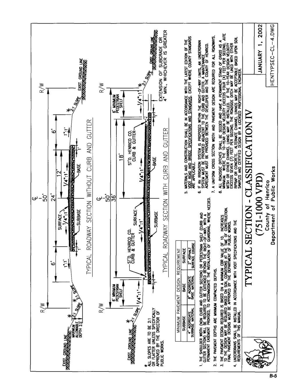
74 i!-!.

75 Q 3- n Id e o r ; w : : z? z 0 E Y 4 0 B-
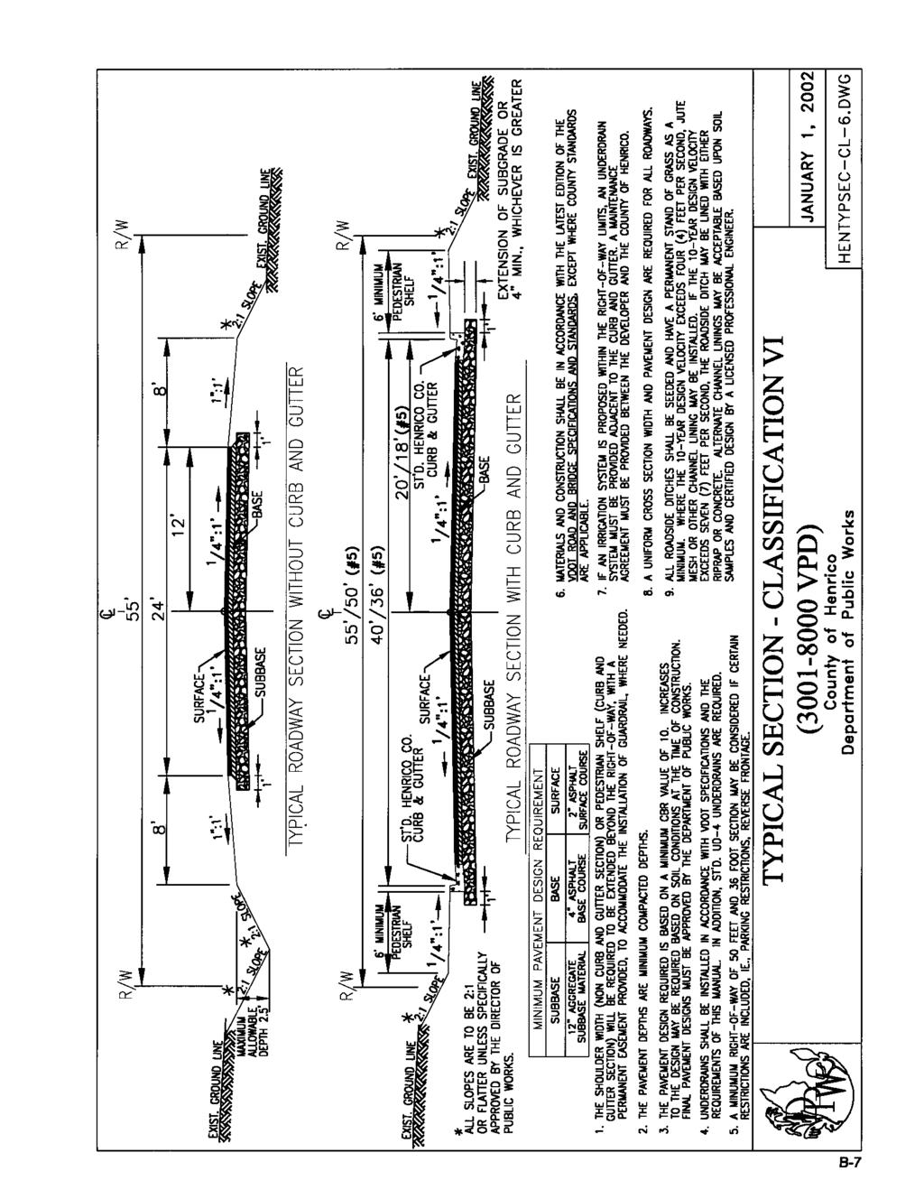
76 #' C U

77 1 ti N 0 N.

78 L i vi d rim d g : z i I

79 CY W c + 3 c3 n z 4 1 LL W rv N L
80 VI Y "i Id G W d d x : z i
81 Appendix C Page Curb and Gutter C-2 Independent Curb C-2.1 Roll Face Curb and Gutter C-3 Pavement Dimensions for Roll Face Curb and Gutter C-3.1 Roll Face Curb Transitions C-4 Standard Entrance Apron Roll Face Curb and Gutter C-5 Standard Entrance Apron - Residential Use C-6 Residential Curb Cut for Driveways C-7 Sidewalk Detail C-8 Combination Curb Cut and Ramp C-9 Curb Returns C-10 Edge of Pavement Return C-11 Guardrail Detail with Curb and Gutter C-12 Guardrail Detail without Curb and Gutter C-13 Raised 14 Foot Median with Left Turn Lane Detail C-14 Right Turn Lane C-15 Temporary Cul-de-Sac C-16 Permanent Cul-de-Sac C-17 Permanent Cul-de-Sac Design Criteria C-18 Modified Cul-de-Sac C-19 Road Extension Sign C-20 Unmaintained Road Sign C-20.1 End of Road Barricade C-21 Pavement Replacement for Pipe Trench C-22 June 1, 2004 C-1
82 Installation of Entrance Pipe C-23 Pipe Bedding and Backfill C-23.1 Right-of-Way Monument C-24 GPS Control Network Monument C-25 June 1, 2004 C-1.1
83 L M 1 6 cn 3 0 W m 1 J 6 I cn w + W L11 0 Z 0 0
84
85
86
87
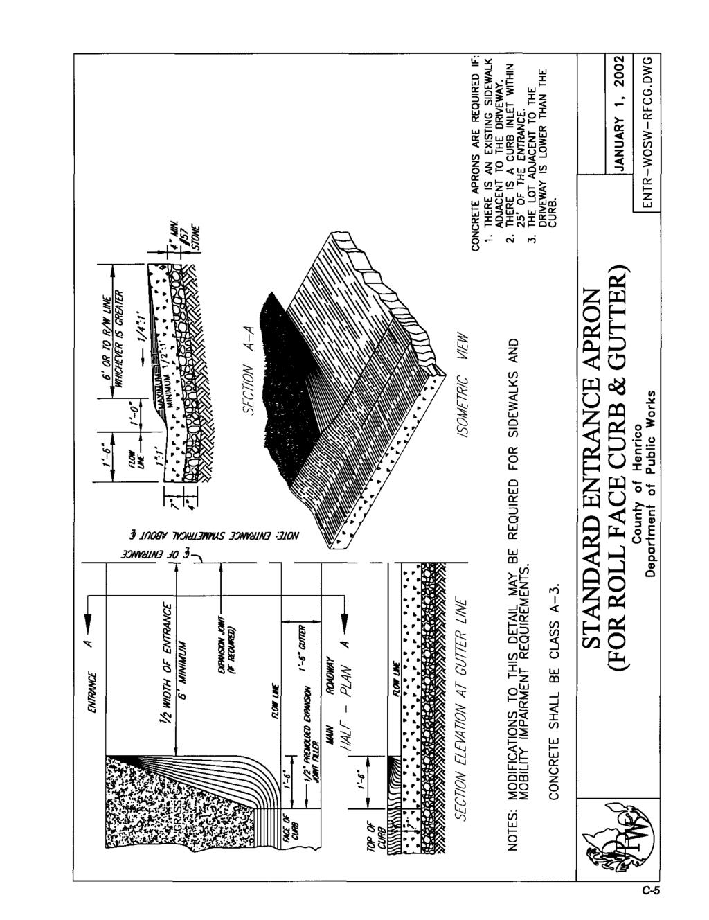
88
89
90 .. L --c1 L- m I m Z 0 - I- o W v, a a I Z 0 - I- o W v, c-7
91 .. W k 0 z - t
92 1 C
93
94 C-'
95 I
96 t- cn 0 a n Z a J - Q CY n Q CY 3 c3 Z W n J J a W K 0 m I W CY a Y w 0 Q LL ly 3 cn n Q 0 C K
97 0 ' c I U T L r c I C-14
98
99
100
101 C-f i
102
103
104
105
106 t -r L 1 1 oa CL.. (I] w I- O z C-21

107
108 \ \ \ L
109
110
111 F- c-2
112 Appendix D Page Information for Submitting Agreements, Declarations, D-2 and Letters of Credit Assignment for Subdivision Defect Bond D-3 Assignment for Erosion Control Measures D-6 Assignment for Unimproved Drive Aprons D-9 Declaration of Covenants Inspection/Maintenance of D-12 Runoff Control Measures Defect Bond D-16 Erosion and Sediment Control Agreement D-19 Letter of Credit Sample Letter D-22 Maintenance Agreement for Improvements in the D-23 Public Right-of-Way January 1, 2002 D-1

113 Henrico County Department of Public Works Information for Submitting Agreements, Declarations and Letters of Credit Because of various legal requirements, all Erosion and Sediment Control Agreements, Letters of Credit, Assignments, and Declaration of Covenants are reviewed by the County Attorney s Office for proper signatures and form. In addition, the Clerk s Office also reviews all Declaration of Covenants submitted for recordation in the Records Room. In order to help you submit documents which can be approved, the County Attorney s Office has prepared the following information. Any documents that do not comply will be rejected. 1. If there is a need to erase, cross out, or add any information to a preprinted form, the persons who sign the document must also initial each change. To prevent fraud, the document may not be modified by anyone other than the persons signing it. Changes must be on an original document, not a copy, in order to be sure that there are not multiple versions of the document. 2. If a church is a contracting party, all trustees for the church must sign. If the document requires notarization, all signatures must be notarized. The notary s acknowledgement should state that each person signing is Trustee of. 3. There must me at least one document with original signatures and, on forms which require notary signatures, original notary signatures. 4. The name of the applicant on the first sheet of the Erosion and Sediment Control Agreement must match the applicant s name on the signature page. For example, if the applicant listed on the first page is an individual, the individual, not a company office, must sign on the signature page. 5. The applicant listed in the Letter of Credit or Assignment must be the same as the applicant in the Erosion Control Agreement. 6. The date of the Erosion and Sediment Control Agreement listed in the Letter of Credit must match the date of the Erosion and Sediment Control Agreement. 7. If a corporation is the contracting party, an officer authorized to sign for the corporation must sign as officer of the corporation and the signature should be notarized as such, e.g., XYS Corporation, by John Smith, President. If a partnership is the contracting party, a partner or officer of the partnership authorized to sign must sign for the partnership and have the signature notarized as such. 8. Letters of Credit may be issued on out-of-area banks but must list a draw address at a bank in the City of Richmond, Chesterfield County, or Henrico County, Virginia. Should you have any questions, please call Ms. Dawn Morris at (804) POST OFFICE BOX / RICHMOND, VIRGINIA FAX (804) ASSIGNMENT FOR SUBDIVISION DEFECT BOND January 1, 2002 D-2
114 ASSIGNMENT FOR SUBDIVISION DEFECT BOND This Assignment made and entered into by and among ("Developer"), the County of Henrico, Virginia, a political subdivision of the Commonwealth of Virginia ("County"), and ("Bank") provides as follows: 1. The Developer owns a certain parcel of real estate located in Henrico County, Virginia, described as Exhibit A attached hereto, which real estate is contemplated to be further developed as a single family residential subdivision ("Property"), known as. 2. The Developer has entered into a contract ("Contract") with certain Subcontractors ("Subcontractors") by which the Subcontractors will construct the Improvements in accordance with requirements of the Code of Henrico County, Virginia, Henrico County Department of Public Works, and conditions imposed hereunder by the Planning Commission (all of which are collectively referred to herein as the "Requirements"). 3. In connection with its approval of development of the Property, the County desires to obtain security, through the assignment of certain funds evidenced by a Certificate of Deposit held at the Bank, against all loss, cost, damage or expense incurred in the repair and/or replacement of roadway pavement, underlying base material and structures, curb and gutter, driveway entrances, storm sewers, roadway shoulders, and side ditches ("Improvements") from damage or deterioration which occurs within the boundaries of the public right of way and/or public drainage easement, or for damage to such Improvements occurring, appearing or manifesting itself within the one (1) year period described herein. follows: NOW, THEREFORE, in consideration of the mutual covenants contained herein, the parties agree as 1. Assignment of Certificates of Deposit. The Developer hereby irrevocably assigns to the County January 1, 2002 D-3
115 all of its right, title, and interest in and to funds represented by a Certificate of Deposit in the face amount of $ issued by the Bank, copies of which are attached hereto as Exhibit B ("Certificate"), as security for the maintenance of the Improvements. The Certificate shall be held by the Bank as escrow agent for the County. The Bank shall hold the Certificate and its principal amount for the benefit of the County. The Bank shall not release the Certificate to the Developer or other third party unless directed by the official of the County charged with the enforcement of the Requirements pursuant to the terms and conditions set forth in this Assignment. 2. Payment of Assigned Proceeds. If the Developer does not complete, construct, repair and maintain the Improvements in accordance with the Requirements within one (1) year of the date of this assignment, then the funds evidenced by the Certificate shall be paid directly by the Bank to the County. As a condition precedent to receiving the funds assigned hereunder, the County shall provide the Bank with a certified statement, signed by an official charged with the enforcement of Requirements, stating that the Developer has failed to satisfactorily repair and maintain the Improvements in accordance with the Requirements. Upon receipt of such certified statement, the Bank will be unconditionally obligated to release the funds to the County. Upon receipt of such funds from the Bank, the County shall forthwith apply same for the sole and exclusive purpose of maintenance of the Improvements, and upon completion of such Improvements, shall promptly return all unused amounts thereof to the Developer. 3. Termination. This Assignment shall terminate and be of no further force and effect on the date upon which maintenance of all Improvements has been completed and accepted in accordance with the Requirements, as evidenced by a certified statement signed by an official charged with the enforcement of the Requirements stating that the Developer has satisfactorily repaired and maintained all Improvements required by this Agreement and authorizing all funds assigned hereunder to be returned to the Developer. 4. Warranties. The Bank warrants that there are no legal or equitable defenses currently available to the Bank that might affect the County's ability to use proceeds of the Certificate for the purpose of completing January 1, 2002 D-4
116 repair or maintenance of the Improvements. The Developer warrants that there are no defects or prior liens incumbent on the properties. 5. Effect of Assignment. Nothing herein shall be construed to relieve the Developer of its independent legal obligation to complete and maintain the Improvements. 6. Interpretations. This Assignment shall be governed by and construed in accordance with the laws of Commonwealth of Virginia and shall be binding on the parties, their successors and assigns. WITNESS the following signatures and seals all as of this day of. (Bank) By Title (Developer) By Title COUNTY OF HENRICO, VIRGINIA Approved as to form: By Director of Public Works/County Engineer Assistant County Attorney 11/98 Rev. January 1, 2002 D-5
117 ASSIGNMENT FOR EROSION CONTROL MEASURES This Assignment made and entered into by and among ("Developer"), the County of Henrico, Virginia, a political subdivision of the Commonwealth of Virginia ("County"), and ("Bank") provides as follows: 1. The Developer owns a certain parcel of real estate located in Henrico County, Virginia, described as Exhibit A attached hereto, which real estate has been developed as a single family residential subdivision or plan of development ("Property"), known as. 2. The Developer has entered into a contract ("Contract") with certain Subcontractors ("Subcontractors") by which the Subcontractors will construct the Erosion Control Measures in accordance with requirements of the Code of Henrico County, Virginia, and conditions imposed hereunder by the Department of Public Works (all of which are collectively referred to herein as the "Requirements"); and 3. In connection with its approval of development of the Property, the County desires to obtain security, through the assignment of certain funds evidenced by a Certificate of Deposit held at the Bank, for the installation and maintenance of Erosion Control Measures in accordance with the Requirements. NOW, THEREFORE, in consideration of the mutual covenants contained herein, the parties agree as follows: 1. Assignment of Certificates of Deposit. The Developer hereby irrevocably assigns to the County all of its right, title, and interest in and to funds represented by a Certificate of Deposit in the face amount of issued by the Bank, copies of which are attached hereto as Exhibit B ("Certificate"), January 1, 2002 D-6
118 as security for construction, completion, and the maintenance of the Erosion Control Measures. The Certificate shall be held by the Bank as escrow agent for the County. The Bank shall hold the Certificate and its principal amount for the benefit of the County. The Bank shall not release the Certificate to the Developer or other third party unless directed by the official of the County charged with the enforcement of the Requirements pursuant to the terms and conditions set forth in this Assignment. 2. Payment of Assigned Proceeds. If the Developer does not complete, construct, and maintain the Erosion Control Measures in accordance with the Requirements of Henrico County Department of Public Works, then the funds evidenced by the Certificate shall be paid directly by the Bank to the County. As a condition precedent to receiving the funds assigned hereunder, the County shall provide the Bank with a certified statement, signed by an official charged with the enforcement of the Requirements, stating that the Developer has failed to satisfactorily construct, complete, and maintain the Erosion Control Measures in accordance with the Requirements. Upon receipt of such certified statement, the Bank will be unconditionally obligated to release the funds to the County. Upon receipt of such funds from the Bank, the County shall forthwith apply same for the sole and exclusive purpose of construction, completion and maintenance of the Improvements, and upon completion of such Erosion Control Measures, shall promptly return all unused amounts to the Developer. 3. Termination. This Assignment shall terminate and be of no further force and effect on the date that completion of the land-disturbing activity and achievement of adequate stabilization of the land has occurred, as evidenced by a certified statement signed by the Director of the Department of Public Works verifying that the Developer has satisfactorily constructed, completed and maintained all Erosion Control Measures and adequately stabilized the disturbed area(s) required by this Agreement and authorizing all funds assigned hereunder to be returned to the Developer. If the improvements are not completed at the end of the term of the Certificate, the Certificate shall be renewed. 4. Warranties. The Bank warrants that there are no legal or equitable defenses currently available to the Bank that might affect the County's ability to use proceeds of the Certificate for the January 1, 2002 D-7
119 purpose of completing maintenance of the Erosion Control Measures. The Developer warrants that there are no defects or prior liens incumbent on the properties. 5. Effect of Assignment. Nothing herein shall be construed to relieve the Developer of its independent legal obligation to complete and maintain the Erosion Control Measures. 6. Interpretations. This Assignment shall be governed by and construed in accordance with the laws of Commonwealth of Virginia and shall be binding on the parties, their successors and assigns. WITNESS the following signatures and seals all as of this day of, 20. (Bank) By Title (Developer) By Title COUNTY OF HENRICO, VIRGINIA Approved as to form: By Director of Public Works/County Engineer Assistant County Attorney 02/01 Rev. January 1, 2002 D-8
120 ASSIGNMENT FOR UNIMPROVED DRIVE APRONS This Assignment made and entered into by and among ("Developer"), the County of Henrico, Virginia, a political subdivision of the Commonwealth of Virginia ("County"), and ("Bank") provides as follows: 1. The Developer owns a certain parcel of real estate located in Henrico County, Virginia, described as Exhibit A attached hereto, which real estate is contemplated to be further developed as a single family residential subdivision ("Property"), known as. 2. The Developer has entered into a contract ("Contract") with certain Subcontractors ("Subcontractors") by which the Subcontractors will construct the Improvements (Driveway Aprons) in accordance with requirements of the Code of Henrico County, Virginia, the Virginia Department of Transportation, Henrico County Department of Public Works, and conditions imposed hereunder by the Planning Commission (all of which are collectively referred to herein as the "Requirements"); and 3. In connection with its approval of development of the Property, the County desires to obtain security, through the assignment of certain funds evidenced by a Certificate of Deposit held at the Bank, for the installation and maintenance of Improvements (Driveway Aprons) remaining to be completed at the execution of this Agreement in accordance with the Requirements. NOW, THEREFORE, in consideration of the mutual covenants contained herein, the parties agree as follows: 1. Assignment of Certificates of Deposit. The Developer hereby irrevocably assigns to the County all of its right, title, and interest in and to funds represented by a Certificate of Deposit in the face amount of issued by the Bank, copies of which are attached hereto as Exhibit B ("Certificate"), as security for construction, completion, and the maintenance of the Improvements (Driveway Aprons). The Certificate shall be held by the Bank as escrow agent for the County. The Bank shall hold the Certificate and its principal amount for the benefit of the County. The Bank shall not January 1, 2002 D-9
121 release the Certificate to the Developer or other third party unless directed by the official of the County charged with the enforcement of the Requirements pursuant to the terms and conditions set forth in this Assignment. 2. Payment of Assigned Proceeds. If the Developer does not complete, construct, and maintain the Improvements (Driveway Aprons) in accordance with the Requirements of Henrico County Department of Public Works within one (1) year of the date of this assignment, then the funds evidenced by the Certificate shall be paid directly by the Bank to the County. As a condition precedent to receiving the funds assigned hereunder, the County shall provide the Bank with a certified statement, signed by an official charged with the enforcement of the Requirements, stating that the Developer has failed to satisfactorily construct, complete, and maintain the improvements in accordance with the Requirements. Upon receipt of such certified statement, the Bank will be unconditionally obligated to release the funds to the County. Upon receipt of such funds from the Bank, the County shall forthwith apply same for the sole and exclusive purpose of construction, completion and maintenance of the Improvements, and upon completion of such Improvements, shall promptly return all unused amounts to the Developer. 3. Termination. This Assignment shall terminate and be of no further force and effect on the date upon which construction and maintenance of all Improvements has been completed and accepted in accordance with the Requirements, as evidenced by a certified statement signed by an official charged with the enforcement of the Requirements stating that the Developer has satisfactorily constructed, completed and maintained all Improvements required by this Agreement and authorizing all funds assigned hereunder to be returned to the Developer. 4. Warranties. The Bank warrants that there are no legal or equitable defenses currently available to the Bank that might affect the County's ability to use proceeds of the Certificate for the purpose of completing the Improvements. The Developer warrants that there are no defects or prior liens incumbent on the properties. January 1, 2002 D-10
122 5. Effect of Assignment. Nothing herein shall be construed to relieve the Developer of its independent legal obligation to complete and maintain the Improvements. 6. Interpretations. This Assignment shall be governed by and construed in accordance with the laws of Commonwealth of Virginia and shall be binding on the parties, their successors and assigns. WITNESS the following signatures and seals all as of this day of. (Bank) By Title (Developer) By Title COUNTY OF HENRICO, VIRGINIA Approved as to form: By Title Assistant County Attorney 11/98 Rev. January 1, 2002 D-11
123 DECLARATION OF COVENANTS INSPECTION/MAINTENANCE OF RUNOFF CONTROL MEASURES THIS DECLARATION, made this day of,20, between, and all successors and assigns in title and interest, hereinafter referred to as the "COVENANTOR(S)," owner(s) of the following property: on which best management practices, hereinafter referred to as "BMPs", or stormwater management facilities, hereinafter referred to as SWM Facilities, to control stormwater runoff have been constructed, and County of Henrico, Virginia, hereinafter referred to as the "COUNTY." WITNESSETH: We, the COVENANTOR(S), with full authority to execute deeds, mortgages, other covenants, and all rights, titles and interests in the property described above, do hereby covenant with the COUNTY as follows: 1. The COVENANTOR(S) shall provide maintenance for the BMPs and/or SWM Facilities located on and serving the above-described property to ensure that the BMPs and/or SWM Facilities are and remain in proper working condition in accordance with approved design standards and with applicable legal requirements. 2. If necessary, the COVENANTOR(S) shall levy regular or special assessments against all present or subsequent owners of property served by the BMPs January 1, 2002 D-12
124 and/or SWM Facilities to ensure that the BMPs and/or SWM Facilities are properly maintained. 3. The COVENANTOR(S) shall provide and maintain perpetual access from public rights-of-way to the BMPs and/or SWM Facilities for the COUNTY, its officers, agents, employees, and contractors. 4. The COVENANTOR(S) shall grant the COUNTY, its officers, agents, employees and contractors, a right of entry to the BMPs and/or SWM Facilities for the purpose of inspecting, operating, installing, constructing, reconstructing, maintaining or repairing the BMPs and/or SWM Facilities, as necessary. 5. If, after reasonable notice by the COUNTY, the COVENANTOR(S) shall fail to maintain the BMPs and/or SWM Facilities to control stormwater runoff in accordance with the requirements of Section of the County Code in effect at the date of these covenants, the COUNTY may perform all necessary repair or maintenance work, and the COUNTY may assess the COVENANTOR(S) and/or all property served by the BMPs and/or SWM Facilities for the cost of the work and any applicable penalties. 6. The COVENANTOR(S) shall indemnify and save the COUNTY its officers, agents, employees and contractors harmless from any and all claims for damages and injuries to persons or property arising from the installation, construction, maintenance, repair, operation or use of the BMPs and/or SWM Facilities. January 1, 2002 D-13
125 7. The COVENANTOR(S) shall promptly notify the COUNTY when the COVENANTOR(S) legally transfer or assign any of the COVENANTOR(S)' responsibilities for the BMPs and/or SWM Facilities. The COVENANTOR(S) shall supply the COUNTY with a copy of any document of transfer, executed by both parties. 8. The covenants contained herein shall run with the land and shall bind the COVENANTOR(S) and the COVENANTOR(S)' heirs, executors, administrators, successors and assignees, and shall bind all present and subsequent owners of property served by the BMPs and/or SWM Facilities as long as they own an interest in the property. 9. This COVENANT shall be recorded in the Circuit Court of Henrico County. IN WITNESS WHEREOF, the COVENANTOR(S) have executed this DECLARATION OF COVENANTS as of this day of, 20. COVENANTOR(S) ATTEST: COVENANTOR(S) ATTEST: January 1, 2002 D-14
126 STATE OF VIRGINIA CITY/COUNTY OF I hereby certify that on the day of, 20, before the subscribed, a Notary Public of the State of Virginia, and for the City/County of, aforesaid personally appeared before me, Name of COVENANTOR(S) and did acknowledge the aforegoing instrument to be their Act. IN WITNESS WHEREOF, I have hereunto set my hand and official seal this day of, 20. Notary Public My Commission expires: Approved as to form: REV. 8/01 2/06 January 1, 2002 D-15
127 DEFECT BOND KNOW ALL MEN BY THESE PRESENTS, that we,, (Principal) and, a corporation duly incorporated under the laws of the State of, (Surety) are held firmly bound unto the County of Henrico, Virginia, (County) in the full and just sum of Dollars ($ ), current money of the United States, to be paid to the County, to payment whereof we hereby bind ourselves and each of us and each of our heirs, executors, administrators, successors and assigns, jointly and severally, this day of, WHEREAS, Principal has constructed and County has accepted or will in the near future determine whether or not to accept into the County system of roads, the street, road and drainage improvements described below together with adjacent street or roadway pavement, underlying base material, surface and subsurface structures, curb and gutter, driveway entrances, storm sewers, roadway shoulders and side and public drainage improvements lying within the boundaries of the right-of-way and/or any public drainage easement described as follows: NOW, THEREFORE, the condition of this obligation is such that if Principal shall, according to the terms of the defect bond, indemnify and save harmless the County for a period of one (1) year from the date of acceptance of the above-described improvements by the County from all loss, cost, damage or expense incurred in the repair and/or replacement of roadway pavement, underlying base material and structures, curb and gutter, driveway entrances, storm sewers, roadway shoulders, and side ditches, which damage or deterioration occurs within the boundaries of the public right-of-way and/or any public drainage easement, and damage to other work or improvements resulting therefrom and occurring, appearing or manifesting itself within the one (1) year period described herein, then this obligation shall be void; otherwise, it shall remain in full force and effect. It is expressly understood that this bond shall not be cancelled by Surety and nothing herein shall operate to relieve, release or discharge Surety from liability on this bond. January 1, 2002 D-16
128 Whenever Principal shall fail, and be declared by County to have failed, to repair or replace the above-described improvements or correct such damage or deterioration: Surety, upon demand by County, shall promptly remedy or cause to be remedied such failure; or, County, after five (5) days written notice to Surety may perform or arrange for performance of Principal s obligations and Surety shall promptly reimburse County for the actual cost of such performance; provided, however, that in no event shall the liability of Surety exceed the face amount of this bond. The expiration of this bond shall not relieve Surety from any liability previously accrued pursuant to this bond. IN WITNESS WHEREOF, Principal and Surety have caused these presents to be executed and their seals affixed on the day and during the year above written. Principal Name Address Surety Countersigned: By Resident Virginia Agent Attorney In Fact January 1, 2002 D-17
129 ACKNOWLEDGEMENT FOR PRINCIPAL State of County/City of, to wit: I,, a Notary Public in and for the County/City and State aforesaid, do certify that, whose name is signed to the foregoing bond, personally appeared before me in my County/City and State aforesaid and acknowledged the same to be his act and deed. My commission expires. Given under my hand and seal this day of, 20. Notary Public ACKNOWLEDGEMENT FOR SURETY State of County/City of, to wit: I,, a Notary Public in and for the County/City and State aforesaid, do certify that, whose name is signed to the foregoing bond, personally appeared before me in my County/City and State aforesaid and acknowledged the same to be his act and deed. My commission expires. Given under my hand and seal this day of, 20. Notary Public (REV. 02/01) January 1, 2002 D-18
130 Erosion and Sediment Control Agreement THIS AGREEMENT, made this day of,, by and, hereinafter called "Developer", party of the first part, and the County of Henrico, Virginia, hereinafter called "County", party of the second part. W I T N E S S E T H WHEREAS, Developer desires approval of plans for, which include provisions for erosion and sediment control measures as required by Chapter 10 of the Code of the County of Henrico, Virginia, and WHEREAS, County desires to insure the installation, maintenance, and adequate performance of such control measures. NOW, THEREFORE, in consideration of the foregoing premises and the following terms and conditions, as well as approval of the aforesaid plans by the County and the issuance of permits for the work, the parties hereto agree as follows: 1. Developer has provided the County financial security for the performance of its obligations in the amount of by cash, irrevocable letter of credit or an assignment for erosion control measures ( assignment ), the terms and conditions of which are acceptable in substance and in form to the County Attorney. The cash deposit, letter of credit or assignment is designed to insure full and complete reimbursement to the County in the event that it performs work or causes work to be performed pursuant to paragraphs 2, 3, and 4 of this agreement. 2. In the event developer has not conducted measures for the control of sedimentation and erosion as provided by the plans, or on any approved revision, prior to the occurrence of any rainstorm or other event actually causing any sedimentation or erosion, County shall have the right to enter upon Developer's property and construct such measures or do such other work as may be necessary to prevent further erosion or sedimentation, provided that County shall first give notice in writing to Developer. January 1, 2002 D-19
131 3. In the event Developer has constructed measures for the control of sedimentation and erosion but through overload or inadequate maintenance, they fail to perform the function for which they were intended, County may enter upon Developer s property to perform such reconstruction or maintenance as may be necessary to restore performance in accord with the plans, or approved revisions thereof, upon giving notice in writing to Developer. 4. In the event sedimentation or erosion from the property covered by the plans occurs in sufficient quantity to adversely affect downstream drainage, or travel on any street, road, highway, or other public way, then County may take all necessary steps to restore functions to the affected drainage area or travel way without prior written notice. 5. In the event County performs or causes to be performed work under the provisions of paragraphs 2, 3, and 4 above, either by County forces or private contractor, the County may draw upon Developer's cash deposit, letter of credit or assignment in the amount necessary for complete reimbursement of County for such work. The County will deliver or mail to Developer a copy of an invoice for work performed. 6. In the event County draws upon the Developer s financial security, Developer agrees within ten (10) calendar days of such disbursement either: a. to deposit an amount sufficient to restore the cash amount to its original balance; or b. to furnish an additional letter of credit or assignment in the amount necessary to restore the amount of the initial letter of credit or assignment. 7. In addition to paragraph 6 above, where the cost to the County for work performed pursuant to the provisions of paragraphs 2, 3, and 4 above exceeds the amount of the cash deposit, letter of credit or assignment held by the County, Developer shall pay in full to the County the cost incurred by the County in excess of the cash deposit, letter of credit or assignment within ten (10) calendar days of the time the County incurred such cost. 8. The parties agree that the purpose of this agreement is to insure the installation, maintenance, and performance of measures for the control of erosion and sedimentation and to provide January 1, 2002 D-20
132 for the restoration of facilities for drainage or vehicular travel if such facilities are adversely affected by sedimentation or erosion from the Developer s property. 9. The parties agree that the cash deposit, letter of credit or assignment shall be held by the County until utilized in accordance with paragraph 5 or released in writing by the County s Director of Public Works. WHEREFORE, the parties have executed this agreement by their signatures below. Developer Attest By: (Seal) Its County of Henrico, Virginia By: Director of Public Works/County Engineer Rev. 2/01 January 1, 2002 D-21
133 BANK LETTERHEAD Date County of Henrico, Virginia Department of Public Works P.O. Box Richmond, Virginia Attention: County Engineer Gentlemen: We hereby open our Irrevocable Letter of Credit No. ( ) in your favor for the account of ( Name of Developer ), ( Address ) for a sum not exceeding (Gross sum required on Erosion and Sediment Control Agreement) available by your sight drafts on the (Name of Bank) at (address), Richmond, Virginia, and accompanied by documents specified below: A certified statement signed by an official of Henrico County, Virginia stating that the ( Name of Developer ) has not satisfactorily provided for the control of sedimentation and/or erosion as required by Chapter 10 of the Code of the County of Henrico, Virginia, as stated in the Erosion and Sediment Control agreement dated (Date) and as provided by the approved plans for (Name of Project). A statement signed by an official of Henrico County to the effect that the drawing is for the explicit purpose of providing for the control of sedimentation and/or erosion pursuant to the terms of the Code of the County of Henrico, Virginia (and any amendment thereto) and as provided on the approved construction plans for (Name of Project). All drafts must bear the clause "Drawn under the (Name of Bank) Letter of Credit No. ( ) dated ( )." We hereby engage with drawers, endorsers, and bona fide holders that all drafts drawn in compliance with the terms of this credit shall be duly honored upon presentation and delivery of the documents. This Irrevocable Letter of Credit shall remain in full force and effect for a period of three (3) years from the date hereof. While this Letter of Credit is in effect, the County may draw up to the full amount of the sum at (must be a Richmond location). This credit shall be terminated upon the County of Henrico s County Engineer (or his appointed agent) giving written release to ( Name of Developer ) stating that he has well and truly performed and fulfilled the obligations of the required improvements for (Name of Project ).This Irrevocable Letter of Credit shall be construed in accordance with the "Uniform Customs and Practices for Commercial Documentary Credits" promulgated by the XIII Congress of the International Chamber of Commerce (International Chamber of Commerce Brochure No. 500, 1993 revision) and the provisions of the Uniform Commercial Code - Letters of Credit - Title 8.5 of the Code of Virginia, 1950, as amended. Very truly yours, (Corporate Seal) Rev. 7/98 (Name of Bank) (Authorized Bank Officer) January 1, 2002 D-22
134 MAINTENANCE AGREEMENT FOR IMPROVEMENTS IN THE PUBLIC RIGHT OF WAY HENRICO COUNTY DEPARTMENT OF PUBLIC WORKS THIS AGREEMENT ( Agreement ) is entered into this day of, 20, by and between a ( Owner ), and COUNTY OF HENRICO, VIRGINIA, a political subdivision of the Commonwealth of Virginia ( County ). Recitals WITNESSETH: Owner is the owner and developer of certain real property in the District of Henrico County, Virginia, known as. Pursuant to the development of, Owner wishes to place improvements in the public right-of-way. In accordance with plans prepared by ( Engineer ) dated, ( Plans ), Owner will install a within the rightof-way of ( Road ). Owner and County enter into this agreement to provide for the installation and maintenance of such. Agreement In consideration of the mutual promises, benefits and covenants contained herein, the receipt and sufficiency of which are acknowledged by each of the parties hereto, the parties hereto agree as follows: 1. Plans. Owner has caused Engineer to prepare Plans, which have been approved by County. All changes and revisions to the Plans shall, as they are prepared and prior to construction, be submitted to and subject to the written approval of the County Engineer. 2. Improvements. Owner shall have the right to install the contemplated by the Plans in accordance with the Plans. Owner shall be responsible for the operation and maintenance of the. County shall have no responsibility whatsoever in connection with the operation and maintenance of such, and Owner shall indemnify and hold County harmless from any liability that may result from the operation or deterioration of the. Any damage to the roadbed or other public structures resulting from installation or maintenance of the shall be the responsibility of Owner. 3. Maintenance. If at any time the County Engineer determines that any maintenance is required of Owner within the right-of-way of the Road, the County Engineer will give Owner written notice stating in reasonable detail the required January 1, 2002 D-23
135 maintenance work. Thereafter, Owner shall, at its own expense, promptly perform such maintenance work. If such maintenance work is not completed within sixty (60) days from receipt of such notice, or if within such sixty (60) day time period the work is not, in the sole opinion of the County Engineer, being diligently pursued and continues not to be diligently pursued to completion (unless prevented or delayed because of adverse or unfavorable weather conditions), or in the event of an emergency requiring that maintenance work be performed immediately in the sole opinion of the County Engineer, then the County may but is not required to perform maintenance work, and the County Engineer or his designee shall notify Owner of the amount of all costs incurred in performing such work. Owner hereby agrees to fully reimburse the County for the cost of such maintenance work. The foregoing shall not be deemed to prevent Owner from disputing whether such work is the responsibility of Owner under the terms of this Agreement. 4. Miscellaneous. a. Owner shall have the right to assign its rights and obligations hereunder to an owner s association ( Association ), organized to maintain the within the right-of-way of the Road in which event the obligations of Owner hereunder shall terminate. This Agreement shall be binding upon successors and assigns of the rights and obligations of Owner or Association as provided herein, but it is not intended to and shall not be a covenant running with any real estate now or hereafter owned by Owner or the Association, or either of their respective successors and/or assigns. No obligations imposed on Owner or the Association, or either of their successors and assigns, by this Agreement shall constitute a lien or otherwise encumber the title to any such real estate, it being intended that all obligations of Owner and the Association provided herein are personal to Owner or the Association, as the case may be, and the successors and assigns of their respective rights and obligations contained herein. Owner shall, at its expense, cause this Agreement to be recorded in the Clerk s Office of the Henrico County Circuit Court and indexed in the name of Owner as grantor and the County as grantee. b. Nothing herein shall be construed to limit the right of Owner or the Association to sell, lease or otherwise dispose of or transfer title to all or any part of any land owned by either of them. 5. Termination. This Agreement shall terminate and be of no further force or effect upon the discontinuance and abandonment of the with the right-of-way of the Road in accordance with procedures approved by the County, which approval shall not be unreasonably withheld. 6. Notices. All notices required, permitted or given pursuant to or in connection with this Agreement shall be sufficient if in writing and delivered in person or mailed by certified mail, return receipt requested, to the following persons at the following addresses: January 1, 2002 D-24
136 Owner: County: (Name ) (Title) The County of Henrico, Virginia P.O. Box Richmond, Virginia Attention: County Engineer or to such other addresses of which notice shall have been pursuant to this paragraph. Notices shall be deemed given upon mailing. The obligations of Owner shall neither be assigned nor transferred to any successor or assign of Owner until such time as Owner and such successor or assign shall have each notified the County Engineer, in writing, of the name and address or a person duly authorized to receive notice on behalf of the successor or assign pursuant to this Agreement. If the name or address of any person authorized to receive notification pursuant to this Agreement changes, each party to this Agreement covenants that such party shall immediately notify, in writing, by the above-described procedure, each other party to this Agreement of such change. 7. Complete Agreement. This Agreement contains the entire understanding of the parties, and no amendment or modification shall be binding unless in writing and signed by all parties hereto. 8. Waiver. The failure of the County, the Association or Owner, their successors and assigns, to exercise, or to delay in exercising any right under this Agreement in the event of default, shall not be deemed to be and shall not constitute a waiver with respect to any subsequent default. 9. Paragraph Headings. The paragraph headings contained in this Agreement are intended for convenient reference only, and shall not be construed to affect the meaning or construction of any provisions of this Agreement. 10. Successors and Assigns. Whenever used in this Agreement, successors and assigns means the successors and assigns of Owner to its rights and obligations under this Agreement, or the successors and assigns of the Association to its rights and obligations under this Agreement, as the case may be, and does not refer to any other successors and assigns of Owner or the Association. 11. Jurisdiction. This agreement shall be governed by the laws of the Commonwealth of Virginia, and all disputes shall be resolved in the Circuit Court of the County of Henrico. January 1, 2002 D-25
137 WHEREFORE, the parties hereto have caused this Agreement to be executed by their respective duly authorized representatives:, a By: Title: ATTEST: COUNTY OF HENRICO, VIRGINIA A political subdivision of the Commonwealth of Virginia By: Title: Clerk APPROVED AS TO FORM: (Assistant) County Attorney STATE OF, CITY/COUNTY OF, to wit: The foregoing instrument was acknowledged before me this day of, 20, by,, a, on behalf of the. My commission expires: Notary Public January 1, 2002 D-26
138 COMMONWEALTH OF VIRGINIA CITY/COUNTY OF, to wit: The foregoing instrument was acknowledged before me this day of, 20, by,, of the County of Henrico, a political subdivision of the Commonwealth of Virginia. My commission expires: Notary Public REV..7/01 January 1, 2002 D-27
139 Appendix E Page Permit to Work in the Right-of-Way E-2 Special Provisions for Working in the County E-3 Right-of-Way Agreement for Use of the Public Right-of-Way E-7 and Insurance Specifications Schedule for Calculating Financial Guarantees for Work E-12 In County Right-of-Way Insurance Specifications E-13 January 1, 2002 E-1
140 DEPARTMENT OF PUBLIC WORKS COUNTY OF HENRICO P.O. BOX HENRICO, VIRGINIA PERMIT NO. One (1) copy of application and four (4) copies of plans are hereby made to the Director of Public Works at Henrico County, Richmond, Virginia, for a permit to perform the work shown on the accompanying plans and further described as follows: DESCRIPTION OF WORK: The work is to be done under and in accordance with the rules and regulations of the County of Henrico, Virginia on the Road, between and Road, and to be completed within days from date of approval. Attached is a check or cash for $ to cover the inspection fee and a guaranty of $ to save the County harmless for any damage done. If a Bond is furnished as guaranty, give the amount of bond and the name and address of Bonding Company. Bond $ Name: Address: It is understood that the County may use any or all of the guaranty to repair any damage resulting from the work and that the balance, if any, will be refunded to the applicant. Work must be inspected during construction by the Department of Public Works, County of Henrico. Dated this day of 20. Company Name Address By Phone No. Name of contact person and phone number to call in case of emergency: Permission is hereby given to (Name) by the County of Henrico, under the powers granted to it by Act of Assembly-1942 to perform the work described at the locations given as set forth above as shown on the plan or sketch submitted in conformance with the attached Special Provisions Approved Time limit expires on: County of Henrico, Virginia By: Please attach plans/sketches to this application
141 COUNTY OF HENRICO DEPARTMENT OF PUBLIC WORKS Special Provisions For Work In County Right-Of-Way This permit is issued with the full understanding that all work shall be performed in a manner acceptable to the Department of Public Works (DPW) at all times. It shall be further understood that this permit can be revoked for unsatisfactory work or failure to comply with the below list of governing conditions for work in the County right-of-way. Unless otherwise noted herein, all materials and construction methods shall be in accordance with the Virginia Department Of Transportation (VDOT) Road & Bridge Specifications And Standards. Special Provisions: 1. The applicant shall be responsible for any and all defects resulting from the work in County right-of-way for a period of 12 months from the date all work is completed. Defects shall include but not limited to pavement, trenches, shoulders, ditches, lawns, pipes, driveways, sidewalks, curb and gutter, etc. 2. Prior to any work, notify the DPW construction inspector. 3. Traffic control shall be in accordance with the Virginia Work Area Protection Manual. Additional signs, barricades, flaggers, electronic arrows and other traffic control devices may be required by the Traffic Engineer, depending on the nature and location of the work. Unless approved by the Traffic Engineer, all lanes of traffic shall be open at the close of each day. 4. The Traffic Engineer shall be notified 24 hours in advance of lane closures or traffic restrictions on arterial or collector roads. Depending on the scope of work, traffic control requirements and public notification requirements, additional notification time may be necessary. Unless otherwise approved, lane closures on arterial and collector roads will be permitted only between 9:00 a.m. and 3:30 p.m. 5. All road closures shall have prior approval of the Traffic Engineer. Sufficient notification of the anticipated road closure is essential to allow for required detour signing and appropriate notifications to the general public, schools, public transportation and emergency services. 6. Unless specifically approved, no open excavation shall be allowed after the close of the workday.
142 7. Unless otherwise approved, no equipment or materials are to be left in the County right-of-way after work hours. Should permission be given to allow equipment and materials in the right-of-way after work hours, group II channelizing devices (plastic barrels with prismatic sheeting) shall be used to delineate the obstacles. Equipment and materials shall be placed in areas that would have no adverse impact to the property owners and shall not obstruct any sight distances. 8. Dust shall be controlled by watering or applying calcium chloride whenever necessary. 9. All dirt, mud and debris tracked onto roadways shall be immediately removed and the road cleaned. 10. The applicant shall comply with all state and federal environmental regulations as well as the County of Henrico Environmental Ordinance (Chapter 10) requirements. All erosion control should be performed in a manner consistent with the Virginia Erosion And Sediment Control Handbook and the Henrico Erosion Control Program. 11. Prior to any work in or adjacent to streams and/or wetlands, contact DPW s Environmental Inspector at Access to adjacent properties shall be maintained at all times. 13. When it appears that the permitted work may have some impact to adjacent private or commercial properties, the applicant shall inform the owners of the proposed work and keep them apprised of time schedules, delays, impacts, changes in pedestrian and vehicle access or traffic patterns and final restoration plans. 14. Restoration of road and earth disturbances shall be on going as work progresses. 15. All disturbances shall be restored to pre-construction condition and be acceptable to DPW. 16. Install cable, manholes and/or boxes as close to the right-of-way line as possible. If utility easements are available, the facilities shall be installed beyond the right of way in the easements. Navigating may be required on backside of ditches in wooded areas. 17. The applicant shall coordinate utility installations with developer/owner in areas of on-going development.
143 18. Unless otherwise approved, utility installations shall maintain 24 horizontal and 12 vertical minimum clearances from the outside diameter of storm sewers and structures. 19. All road crossings shall be bored/navigated. If test holes are required for a bore, approval shall be obtained from DPW prior to excavation. Pavement restoration shall be in accordance with the attached sketch for flush patches. 20. Utility installations across paved driveways, sidewalks, landscaped areas, irrigation systems or sodded lawns shall be bored/ navigated. 21. Disturbed shoulders, ditches and slopes shall be restored to the original typical sections with regards to widths, slopes and elevations and vegetated in a timely manner. 22. Disturbed mailboxes and roadway signs shall be reset immediately after backfill and no later than the close of each workday. 23. When open cutting of driveways and sidewalks is permitted, replacement shall be from the back edge of the trench to the edge of pavement or curb and gutter. Prior to excavation, trench limits shall be sawcut, so as to avoid damage to sections to remain. 24. Disturbances to gravel driveways shall be restored with the same type of stone. 25. Damage to storm sewers and/or drainpipes shall be repaired or replaced, prior to the end of each workday as directed by DPW. 26. Trenches in roadway shall be backfilled with # 21B stone in compacted lifts. Asphalt pavement shall be restored in accordance with the attached sketches. Flush patching will be permitted for a single transverse cut in the pavement. Multiple transverse cuts or longitudinal cuts in the pavement will require full width asphalt overlays throughout the length of disturbances. Unless otherwise approved, temporary or permanent asphalt shall be placed in trenches at the close of each workday. Prior to asphalt overlays, all manhole frame and covers and valve boxes shall be adjusted to proposed finished grade. In shoulder sections, a 12:1 wedge of # 21B stone or topsoil, to match the surface of the existing shoulder, shall be placed along overlay to tie-in the shoulder to the finished grade of the overlay. 27. In curb and gutter sections, it will be necessary to mill the curb lanes, throughout the length of disturbance, to a depth of 2 inches prior to the full width road overlay. Temporary wedges shall be placed for a transition onto uneven pavement. The repaving of milled areas shall be performed within 3 days of the milling operation.
144 28. The applicant shall be responsible for replacing all disturbed pavement markings and messages, within 48 hours of pavement restoration, as directed by the Traffic Engineer. VDOT approved pavement marking contractors shall perform the work. 29. Prior to any work adjacent to a signalized intersection, the applicant shall contact the Traffic Engineer. The applicant shall be responsible for all costs associated with damage to loop detectors, underground conduit, junction boxes, cables, etc. 30. Trenches outside of the pavement shall be backfilled with suitable material in compacted lifts. If the material taken from the trench is deemed unsuitable for backfill by DPW, the material shall be properly disposed of off the right of way by the applicant. Trenches within 1 foot of the pavement shall have 9 of #21b stone placed between the earth backfill and finished grade. In addition, 2 of topsoil should be placed over disturbances in areas where grass shoulders previously existed. 31. When required by the Traffic Engineer, off-duty police shall be used for traffic control. 32. The restoration of concrete items within the County right-of-way and easements shall be made with Class A3 Concrete in accordance with VDOT specifications. 33. For future identification purposes, hand holes, manholes and/or junction boxes shall have the name of the company owning the facility, permanently marked on all access covers. 34. Approval of this permit does not guarantee that sufficient space exists within the County right-of-way for the placement of any portion of this facility. Changes in the routing of the cable and/or easements may have to be obtained by the applicant to facilitate the installation. 35. Other: Contact numbers: Construction Division Inspector Traffic Engineer Environmental Inspector Permit with Provisions Rev. 11/24/09
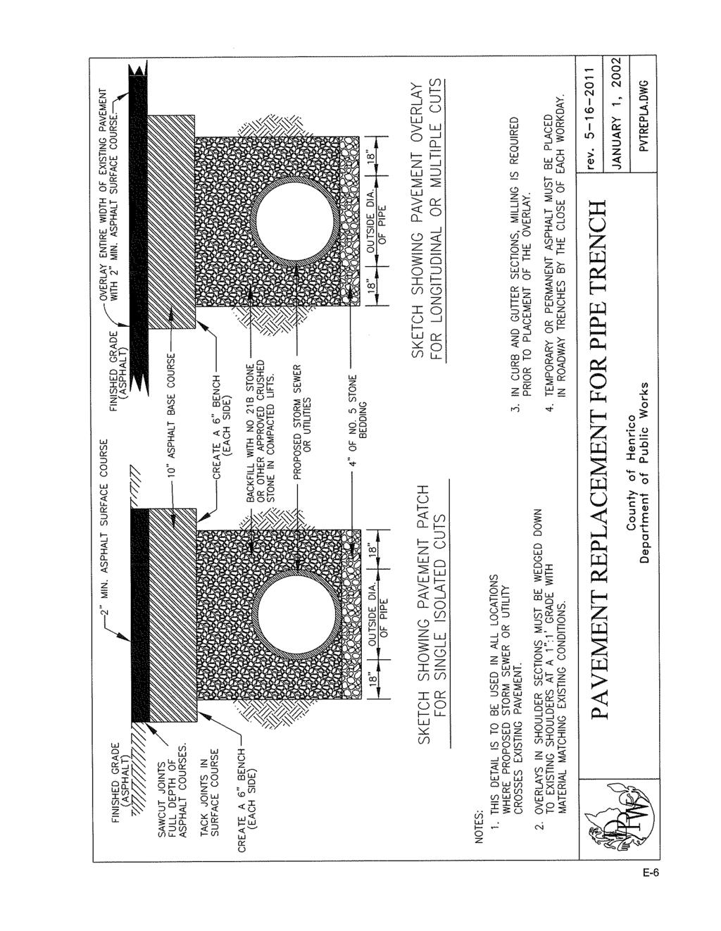
145
M-43 CORRIDOR OVERLAY ZONE
 ARTICLE 26.00 M-43 CORRIDOR OVERLAY ZONE Section 26.01 Findings A primary function of the M-43 state highway is to move traffic through the Township and to points beyond. As the primary east-west arterial
SECTION 7000 LAND DEVELOPMENT REQUIREMENTS
 SECTION 7000 LAND DEVELOPMENT REQUIREMENTS 7000 LAND DEVELOPMENT REQUIREMENTS... 1 7001 LEGISLATIVE AUTHORITY... 1 7001.1 LAND DEVELOPMENT... 1 7001.1.1 Title 40, Idaho Code... 1 7001.1.2 Idaho Code 40-1415
ARTICLE 24 PRIVATE ROAD, SHARED PRIVATE DRIVEWAY AND ACCESS EASEMENT STANDARDS
 ARTICLE 24 PRIVATE ROAD, SHARED PRIVATE DRIVEWAY AND ACCESS EASEMENT STANDARDS SECTION 24.00 INTENT AND PURPOSE The standards of this Article provide for the design, construction and maintenance of private
a. provide for the continuation of collector streets and thoroughfare streets between adjacent subdivisions;
 Section 7.07. Intent The requirements of this Section are intended to provide for the orderly growth of the Town of Holly Springs and its extra-territorial jurisdiction by establishing guidelines for:
ARTICLE 15. RULES, REGULATIONS AND DEFINITIONS
 ARTICLE 15. RULES, REGULATIONS AND DEFINITIONS Section 1. Interpretation and Construction: The following rules and regulations regarding interpretation and construction of the Ulysses-Grant County, Kansas,
Secondary Street Acceptance Requirements Virginia Administrative Code
 Secondary Street Acceptance Requirements Virginia Administrative Code 24VAC30-92-10. Definitions. The following words and terms when used in these regulations shall have the following meanings unless the
DIVISION 2 - CONSTRUCTION PLAN AND MISCELLANEOUS REQUIREMENTS
 DIVISION 2 - CONSTRUCTION PLAN AND MISCELLANEOUS REQUIREMENTS 2.1 Required Plan Sheets 2.2 Drawing Requirements 2.3 Graphic Standards 2.4 Easements 2.5 Utility Locations 2.6 Private Facility Locations
ENGINEERING CODE FOR SUBDIVISION DEVELOPMENT OF MEDINA COUNTY, OHIO BOARD OF MEDINA COUNTY COMMISSIONERS
 ENGINEERING CODE FOR SUBDIVISION DEVELOPMENT OF MEDINA COUNTY, OHIO BOARD OF MEDINA COUNTY COMMISSIONERS PATRICIA G. GEISSMAN THOMAS R. BAHR STEPHEN D. HAMBLEY Adopted by Resolution Dated October 13, 1998
Draft Model Access Management Overlay Ordinance
 Draft Model Access Management Overlay Ordinance This model was developed using the City of Hutchinson and the Trunk Highway 7 corridor. The basic provisions of this model may be adopted by any jurisdiction
ARTICLE 3 DEFINITIONS
 Sections: 3-1 Rules of Construction 3-2 Definitions ARTICLE 3 DEFINITIONS SECTION 3-1 RULES OF CONSTRUCTION 3-101. a. The language set forth in these regulations shall be interpreted in accordance with
THE COUNTY BOARD OF SUPERVISORS OF THE COUNTY OF DOUGLAS DOES ORDAIN AS FOLLOWS:
 8.1 SUBDIVISION CONTROL ORDINANCE THE COUNTY BOARD OF SUPERVISORS OF THE COUNTY OF DOUGLAS DOES ORDAIN AS FOLLOWS: SECTION I. GENERAL INTERPRETATION This ordinance shall not repeal, impair or modify private
-MENDOCINO COUNTY PLANNING AND BUILDING SERVICES- DIVISION OF LAND REGULATIONS TITLE 17
 ARTICLE VI -- GENERAL REGULATIONS AND PROVISIONS Sec. 17-50. Sec. 17-51 General Plan. Sec. 17-52 Lot and Block Design and Configuration. Sec. 17-53 Lot Access. Sec. 17-54 Private Roads. Sec. 17-55 Water
JEFFERSON COUNTY, ALABAMA
 JEFFERSON COUNTY, ALABAMA Major Development Checklist, Notes and Information A Major Development is any proposed new structure or addition to an existing structure which will cause a change in the topography
Virginia Department of Transportation 2005 Subdivision Street Requirements 24 VAC et seq.
 24 VAC 30-91-10. Definitions. CHAPTER 91. SUBDIVISION STREET REQUIREMENTS. PART I. GENERAL PROVISIONS. The following words and terms when used in these regulations shall have the following meanings unless
AN ORDINANCE AMENDING THE CODE OF ORDINANCES OF THE TOWN OF TRYON. Chapter 156 Subdivision Ordinance
 AN ORDINANCE AMENDING THE CODE OF ORDINANCES OF THE TOWN OF TRYON Chapter 156 Subdivision Ordinance Chapter 156: Subdivision Regulations ARTICLE I GENERAL PROVISIONS Section 1.1 Title This Ordinance shall
Article 10. Project Design Standards. Table of Contents. page
 Article 10. Project Design Standards Table of Contents page Sec. 1001 Purpose of Article 10...10-1 Sec. 1002 Standards incorporated by reference....10-1 1002 (a) Standard Design Specifications....10-1
ARTICLE VI. SUBDIVISION STANDARDS, PUBLIC
 ARTICLE VI. SUBDIVISION STANDARDS, PUBLIC IMPROVEMENTS, AND DESIGN REQUIREMENTS ARTICLE VI. SUBDIVISION STANDARDS, PUBLIC IMPROVEMENTS, AND DESIGN REQUIREMENTS DIVISION 1. GENERAL PROVISIONS Sec. 21-6100.
Article 10. Project Design and Construction Standards. Table of Contents DIVISION I. PROJECT DESIGN page
 Article 10. Project Design and Construction Standards Table of Contents page Sec. 1001. Purpose of Article 10.... 10-1 Sec. 1002. Standards incorporated by reference.... 10-1 Sec. 1002.01. Standard design
KASSON TOWNSHIP PRIVATE ACCESS ROAD ORDINANCE ORDINANCE NO (EFFECTIVE: MAY 12, 2007)
") KASSON TOWNSHIP PRIVATE ACCESS ROAD ORDINANCE ORDINANCE NO. 2007-01 (EFFECTIVE: MAY 12, 2007) An ordinance providing for the standards and specifications incident to the development of Private Motor Vehicle
KASSON TOWNSHIP PRIVATE ACCESS ROAD ORDINANCE ORDINANCE NO. 2007-01 (EFFECTIVE: MAY 12, 2007) An ordinance providing for the standards and specifications incident to the development of Private Motor Vehicle
SUBDIVISION DESIGN PRINCIPLES AND STANDARDS
 SECTION 15-200 SUBDIVISION DESIGN PRINCIPLES AND STANDARDS 15-201 STREET DESIGN PRINCIPLES 15-201.01 Streets shall generally conform to the collector and major street plan adopted by the Planning Commission
CHAPTER 92 SECONDARY STREET ACCEPTANCE REQUIREMENTS. The following words and terms when used in these regulations shall have the
 CHAPTER 92 SECONDARY STREET ACCEPTANCE REQUIREMENTS 24VAC30-92-10. Definitions. The following words and terms when used in these regulations shall have the following meanings unless the context clearly
Section Preliminary Plat Checklist and Application Forms
 Section 201 - Preliminary Plat Checklist and Application Forms PRELIMINARY SUBDIVISION PLAT REVIEW PROCESS CHART PRELIMINARY SUBDIVISION PLAT APPLICATION PRELIMINARY PLAT REVIEW CHECKLIST CITY OF NAMPA
SUBDIVISION AND LAND DEVELOPMENT. 185 Attachment 20
 185 Attachment 20 APPENDIX S Plat No. Date of Submission Twp. Fee $ Dauphin Co. Fee $ TOWNSHIP OF DERRY SUBDIVISION OR LAND DEVELOPMENT PLAN SUBMISSION APPLICATION This block for Twp. use only 1. Title
PRELIMINARY PLATS. The following documents are provided as required by the City of Conroe for use in the above titled platting submittals:
 Public Works Engineering Division CITY OF CONROE PRELIMINARY PLATS The following documents are provided as required by the City of Conroe for use in the above titled platting submittals: Submittal Questionnaire
ARTICLE 23 CONDOMINIUM STANDARDS
 ARTICLE 23 CONDOMINIUM STANDARDS Section 23.01 Intent. The intent of this Article is to provide regulatory standards for condominiums and site condominiums similar to those required for projects developed
PART 6 DESIGN STANDARDS
 PART 6 DESIGN STANDARDS SECTION 601 GENERAL The standards and requirements contained in this Part shall apply as minimum design standards for subdivisions and/or land developments in Clay Township. In
c) Stub streets shall be required as follows:
 Stub streets shall be required as follows:") Sec. 7.2.1 / Streets 7.2 DESIGN STANDARDS 7.2.1 Streets A) Interconnectivity 1) Conformity with Apex Transportation Plan. The subdivision s street system shall conform to the Apex Transportation Plan.
Sec. 7.2.1 / Streets 7.2 DESIGN STANDARDS 7.2.1 Streets A) Interconnectivity 1) Conformity with Apex Transportation Plan. The subdivision s street system shall conform to the Apex Transportation Plan.
Appendix A. Definitions
 Definitions 1. Terms Defined. Words contained in this are those having a special meaning relative to the purposes of this Ordinance. Words not listed in this section shall be defined by reference to: (1)
Chapter Plat Design (LMC)
") Chapter 18.14 Plat Design (LMC) Sections: 18.14.010 Lot width 18.14.020 Right-of-way requirements 18.14.030 Pipe stem lots 18.14.040 Division resulting in minimum lot sizes 18.14.050 Flood prone and bad
Chapter 18.14 Plat Design (LMC) Sections: 18.14.010 Lot width 18.14.020 Right-of-way requirements 18.14.030 Pipe stem lots 18.14.040 Division resulting in minimum lot sizes 18.14.050 Flood prone and bad
Article 10. Project Design and Construction Standards
 Article 10. Project Design and Construction Standards Effective January 1, 2009, as Amended through March 2, 2010 Table of Contents page Sec. 1001. Standards incorporated by reference.... 10-1 (a) Standard
ARTICLE IV: DEVELOPMENT STANDARDS
 ARTICLE IV: DEVELOPMENT STANDARDS IV-53 409 PRIVATE STREETS A private street means any way that provides ingress to, or egress from, property by means of vehicles or other means, or that provides travel
STAFF REPORT Administrative Subdivision Hearing West 150 South Street, Parcel # , and
 Petition Number: 490-06-24 STAFF REPORT Administrative Subdivision Hearing Project Name: Project Location: Project Type: Applicant: Planning Staff: Haight Industrial Subdivision 5550 West 150 South Street,
SUBCHAPTER 02C - SECONDARY ROADS SECTION SECTION SECONDARY ROADS
 SUBCHAPTER 02C - SECONDARY ROADS SECTION SECTION.0100 - SECONDARY ROADS Note: The Department of Transportation publishes a volume entitled "Minimum Design and Construction Criteria for Subdivision Streets"
FINAL PLAT APPLICATION
 FINAL PLAT APPLICATION (Page 1 of 3) LEGAL OWNER(s): NAME: STREET ADDRESS OWNER(s): CITY, STATE, ZIP CODE: PHONE NUMBER: BILLING ADDRESS: NAME OF ENGINEER/SURVEYOR: Engineer/Surveyor Address, Phone: PROPERTY
Subdivision - Minor Plat Submittal
 Subdivision - Minor Plat Submittal This Checklist is intended to provide the information and data that is necessary to assess the merits of the project proposal. Please note that this Checklist is intended
CHAPTER 5. Subdivisions Regulations
 CHAPTER 5 Subdivisions Regulations 10-5-1 Introduction and Purpose 10-5-2 Definitions 10-5-3 General Provisions 10-5-4 Procedure for Submitting Subdivisions 10-5-5 Design Standards; Streets and Lots 10-5-6
Planning Grant Contract No. SC P-8 (G) South Carolina State Development Board Division of Community Planning of the Development and Research Center
 South Carolina State Development Board Division of Community Planning of the Development and Research Center") SUBDIVISION REGULATIONS Prepared for: Planning and Zoning Commission Anderson, South Carolina The preparation of this report was financed in part through an Urban Planning grant from the Department of
SUBDIVISION REGULATIONS Prepared for: Planning and Zoning Commission Anderson, South Carolina The preparation of this report was financed in part through an Urban Planning grant from the Department of
610 LAND DIVISIONS AND PROPERTY LINE ADJUSTMENTS OUTSIDE A UGB
 ARTICLE VI: LAND DIVISIONS AND PROPERTY LINE ADJUSTMENTS VI-21 610 LAND DIVISIONS AND PROPERTY LINE ADJUSTMENTS OUTSIDE A UGB 610-1 Property Line Adjustments (Property Line Relocation) A property line
TOWN OF LEWISTON PLANNING BOARD APPLICATION
 TOWN OF LEWISTON PLANNING BOARD APPLICATION DESCRIPTION OF PROPOSED REQUEST: Name of Property Owner: Phone #: Name of Applicant:Phone #: Address or Location of Proposal:_SBL# Size of Parcel or Structure:Existing
MINOR SUBDIVISION PLAT CHECKLIST
 MINOR SUBDIVISION PLAT CHECKLIST Project Name: Tax ID #: Project Number: Date: _ Reviewed By: Telephone: NOTES: All lots on septic systems must comply with the Fulton County Health Department requirements
Community Development Department 333 Broadalbin Street SW, P.O. Box 490 Albany, OR 97321
 SUMMARY Community Development Department 333 Broadalbin Street SW, P.O. Box 490 Albany, OR 97321 STAFF REPORT Application for Tentative Partition Plat Review Planning File PA-06-17 Phone: 541-917-7550
City of Suwanee Development Regulations ARTICLE 10 PLAN AND PLAT SPECIFICATIONS
 ARTICLE 10 PLAN AND PLAT SPECIFICATIONS 10.1 CONCEPT PLAN SPECIFICATIONS The following paragraphs outline the required elements of both the required and optional plans and plats mentioned throughout these
BRIDGETON SUBDIVISION APPLICATION CHECKLIST
 APPLICATION NAME AND # CHECKLIST COMPLETED BY: DATE: Signature and printed name BRIDGETON SUBDIVISION APPLICATION CHECKLIST TO SUBDIVISION APPLICANTS: The attached checklist is to assist you in the submission
CHAPTER 153: RURAL SUBDIVISIONS
 CHAPTER 153: RURAL SUBDIVISIONS Section 153.001 Purpose 153.002 Definitions 153.003 Title 153.004 Adoption of subdivision regulations General Provisions Requirements for Platted Improvements, Resubdivisions,
Condominium Unit Requirements.
 ARTICLE 19 CONDOMINIUM REGULATIONS Section 19.01 Purpose. The purpose of this Article is to regulate projects that divide real property under a contractual arrangement known as a condominium. New and conversion
WEBSTER TOWNSHIP PRIVATE ROAD ORDINANCE
 WEBSTER TOWNSHIP PRIVATE ROAD ORDINANCE Ordinance No. 92-5 Rev. C Webster Township, 5665 Webster Church Road, Dexter, MI 48130 (734) 426-5103 www.twp.webster.mi.us Summary Table of Amendments Adoption
ELK RAPIDS TOWNSHIP ANTRIM COUNTY, MICHIGAN ORDINANCE NO
 ELK RAPIDS TOWNSHIP ANTRIM COUNTY, MICHIGAN ORDINANCE NO. 3-2011 AN ORDINANCE TO REPLACE THE SUBDIVISION CONTROL ORDINANCE WITH A NEW SUBDIVISION DEVELOPMENT ORDINANCE, IN ACCORD WITH THE LAND DIVISION
Chapter 22 LAND USE* Article III. Subdivisions
 Chapter 22 LAND USE* Article III. Subdivisions Sec. 22-256. Authority to Regulate. Sec. 22-257. Scope; plat required. Sec. 22-258. Definitions. Sec. 22-259. Interpretations and Meanings. Sec. 22-260. Procedure
ROAD APPROACH ORDINANCE #44 TILLAMOOK COUNTY OREGON. ADOPTED September 18, UPDATED June 23, UPDATED June 28, UPDATED July 24, 1996
 ROAD APPROACH ORDINANCE #44 TILLAMOOK COUNTY OREGON ADOPTED September 18, 1991 UPDATED June 23, 1993 UPDATED June 28, 1995 UPDATED July 24, 1996 UPDATED June 23, 1999 UPDATED January 1, 2009 UPDATED November
CHAPTER 25 REVIEW AND APPROVAL OF SITE CONDOMINIUM AND CONDOMINIUM PROJECTS
 CHAPTER 25 REVIEW AND APPROVAL OF SITE CONDOMINIUM AND CONDOMINIUM PROJECTS Section 25.1. Purpose and Scope. 1. Tracts of land that are developed and sold as site condominium developments and condominium
SUBDIVISION REGULATIONS
 SUBDIVISION REGULATIONS KANAWHA COUNTY, WEST VIRGINIA KANAWHA COUNTY SUBDIVISION REGULATIONS TABLE OF CONTENTS PARAGRAPH PAGE SECTION I. AUTHORITY Purpose 101 2 Grant of Power 102 2 Effective Date 103
Residential Major Subdivision Review Checklist
 Residential Major Subdivision Review Checklist Plan Submittal Requirements: 2 full sets of stamped plans Electric submittal - all plans contained in a single PDF 3 full sets if commercial kitchen or dining
PRELIMINARY SUBDIVISION AND LAND DEVELOPMENT PLAN CHECKLIST. Applicant's Name:
 TOWNSHIP OF UPPER ST. CLAIR PRELIMINARY SUBDIVISION AND LAND DEVELOPMENT PLAN CHECKLIST Date Filed Plan Name: Applicant's Name: PLC# Phone = OK 0 = Missing; X = Not OK; NA = Not Applicable;? To be Determined;
FINAL SUBDIVISION AND LAND DEVELOPMENT PLAN CHECKLIST. Plan Name. Applicant's Name:
 TOWNSHIP OF UPPER ST. CLAIR FINAL SUBDIVISION AND LAND DEVELOPMENT PLAN CHECKLIST Date Filed Plan Name PLC Applicant's Name: Phone Filing Date for Final Application Final Plat 114.22. FINAL APPLICATION
May 21, ACHD Board of Commissioners Stacey Yarrington, Planner II DRH /DRH
 Development Services Department May 21, 2013 TO: FROM: SUBJECT: ACHD Board of Commissioners Stacey Yarrington, Planner II DRH13-00106/DRH13-00108 Executive Summary: This is a design review application
BYRON TOWNSHIP ZONING APPLICATION
 BYRON TOWNSHIP ZONING APPLICATION Phone: (616) 878-9104 * Fax: (616) 878-3980 * Website: www.byrontownship.org This application will not be accepted if incomplete. APPLICATION FOR & REQUIRED COPIES Private
I. Requirements for All Applications. C D W
 108-16.1. Application checklists. Checklist for Required Submissions to the Planning Board or Zoning Board of Adjustment of Monroe Township All required submissions are to be made to the Administrative
CHAPTER 22 SUBDIVISION AND LAND DEVELOPMENT
 CHAPTER 22 SUBDIVISION AND LAND DEVELOPMENT 22-101. Title 22-102. Legislative Intent Part 1 General Provisions 22-201. Development Permits Part 2 Administration 22-301. Fee Schedule Part 3 Fee Schedule
Section 1: US 19 Overlay District
 Section 1: US 19 Overlay District Section 1.1 Intent and Purpose The purpose of the US Highway 19 Overlay District is to manage access to land development along US Highway 19 in a manner that preserves
ARTICLE PRIVATE ROADS, ACCESS MANAGEMENT, BIKEPATHS, AND SIDEWALKS
 ARTICLE 16 PRIVATE ROADS, ACCESS MANAGEMENT, BIKEPATHS, AND SIDEWALKS Sec. 16-01 Intent It is the intent of this Article to: 2 (a) Provide for access to private property in a manner that protects public
CHAPTER 14: DRIVEWAYS, TOWN HIGHWAYS, AND PRIVATE ROADS
 CHAPTER 14: DRIVEWAYS, TOWN HIGHWAYS, AND PRIVATE ROADS TABLE OF CONTENTS CHAPTER 14: PRIVATE DRIVEWAYS, TOWN HIGHWAYS AND PRIVATE ROADS 14-1 14.0100 AUTHORITY... 14-1 14.0200 TITLE... 14-1 14.0300 REGULATION
MAJOR SUBDIVISION PRELIMINARY PLAT CHECKLIST
 TOWNSHIP OF EGG HARBOR PLANNING BOARD/ZONING BOARD OF ADJUSTMENT 3515 BARGAINTOWN ROAD EGG HARBOR TOWNSHIP, NJ 08234 MAJOR SUBDIVISION PRELIMINARY PLAT CHECKLIST The following checklist is designed to
Appendix C: Iowa Code Relevant to Access Management
 Summary Appendix C contains excerpts from two state documents pertaining to access management in Iowa: (1) Code of Iowa, 1997 Chapter 306A, and (2) the Iowa Primary Road Access Management Policy, July
ARTICLE V: PUBLIC FACILITIES AND SERVICES V PUBLIC FACILITY AND SERVICE REQUIREMENTS
 ARTICLE V: PUBLIC FACILITIES AND SERVICES V 1 501 PUBLIC FACILITY AND SERVICE REQUIREMENTS 501 1 Intent and Purpose The intent of this Section is to identify those public facilities and services that are
Contents. Page. Associated Highway Districts of Kootenai County Highway Standards
 Contents Page Section 100 Introduction 1 101. Authority of Highway Districts... 1 102. Need for Uniformity... 1 103. Non-Discrimination Policy Statement... 2 104. Disclaimer... 2 105. Severability Clause...
PRELMINARY PLAT CHECKLIST
 PRELMINARY PLAT CHECKLIST A. All preliminary plat submitted for approval shall be prepared by a Registered Professional Land Surveyor. B. Preliminary plats must be drawn to a scale of XXX with such accuracy
SPANISH FORT PLANNING COMMISSION PRELIMINARY SUBDIVISION PLAT APPLICATION. Number of Lots (Units) Address. Address.
 Address. Address.") Case No. SPANISH FORT PLANNING COMMISSION PRELIMINARY SUBDIVISION PLAT APPLICATION Name of Subdivision Tax Parcel Number(s) Subdivision Location Total Acreage Number of Lots (Units) Average Lot Size Current
Case No. SPANISH FORT PLANNING COMMISSION PRELIMINARY SUBDIVISION PLAT APPLICATION Name of Subdivision Tax Parcel Number(s) Subdivision Location Total Acreage Number of Lots (Units) Average Lot Size Current
Residential Minor Subdivision Review Checklist
 Residential Minor Subdivision Review Checklist Plan Submittal Requirements: 2 full sets of stamped plans Electric submittal - all plans contained in a single PDF 3 full sets if commercial kitchen or dining
DETAILED GRADING PLAN CHECKLIST (TEARDOWN/REDEVELOPMENT)
") GENERAL DETAILED GRADING PLAN CHECKLIST (TEARDOWN/REDEVELOPMENT) ADDRESS: PERMIT #: DATE: 1. Plan is signed and sealed by an Illinois registered professional engineer including date signed and license
GENERAL DETAILED GRADING PLAN CHECKLIST (TEARDOWN/REDEVELOPMENT) ADDRESS: PERMIT #: DATE: 1. Plan is signed and sealed by an Illinois registered professional engineer including date signed and license
Committed to Service
 Committed to Service Paul Woods, President Rebecca W. Arnold, Vice President Sara M. Baker, Commissioner Jim D. Hansen, Commissioner Kent Goldthorpe, Commissioner August 25, 2017 Development Services TO:
New Private Way Ordinance Westbrook Planning Board Workshop , Planning Board Public Hearing Definitions
 201 Definitions Private Right of Way; Private way A strip of land at least fifty feet wide, meeting the minimum standards for the construction of a gravel base for a public road, over which abutters may
CITY OF HOBBS ORDINANCE NO..
 CITY OF HOBBS ORDINANCE NO.. AN ORDINANCE TO AMEND TITLE 16 OF THE HOBBS MUNICIPAL CODE IN ITS ENTIRETY. BE IT ORDAINED BY THE GOVERNING BODY OF THE CITY OF HOBBS, NEW MEXICO, that the following Chapter
If you have any questions, please feel free to contact me at (208)
") Sara M. Baker, President John S. Franden, Vice President Rebecca W. Arnold, Commissioner Mitchell A. Jaurena, Commissioner Jim Hansen, Commissioner Date: March 21, 2013 To: Subject: Hornet Construction
Sara M. Baker, President John S. Franden, Vice President Rebecca W. Arnold, Commissioner Mitchell A. Jaurena, Commissioner Jim Hansen, Commissioner Date: March 21, 2013 To: Subject: Hornet Construction
Preliminary Subdivision Application (Major) (Four (4) lots or more)
 (Four (4) lots or more)") Gunnison City Offices www.gunnisoncity.org 38 West Center Gunnison, Utah 84634 (435) 528 7969 Date of Application: Preliminary Subdivision Application (Major) (Four (4) lots or more) APPLICANT INFORMATION
Gunnison City Offices www.gunnisoncity.org 38 West Center Gunnison, Utah 84634 (435) 528 7969 Date of Application: Preliminary Subdivision Application (Major) (Four (4) lots or more) APPLICANT INFORMATION
TOWNSHIP OF MARION LIVINGSTON COUNTY, MICHIGAN SUBDIVISION ORDINANCE NO. 5
 TOWNSHIP OF MARION LIVINGSTON COUNTY, MICHIGAN SUBDIVISION ORDINANCE NO. 5 An ordinance regulating the subdivision of land in the Township of Marion, requiring and regulating the preparation and presentation
ORDINANCE NO
 PLEASE TAKE NOTICE that the following Ordinance was introduced on first reading by the Township Committee of the Township of Kingwood, County of Hunterdon, State of New Jersey at a meeting held on the
APPLICATION PROCEDURE
 ANTRIM PLANNING BOARD P. O. Box 517 Antrim, New Hampshire 03440 Phone: 603-588-6785 FAX: 603-588-2969 APPLICATION FORM AND CHECKLIST FOR MINOR OR MAJOR SITE PLAN REVIEW File Date Received By APPLICATION
E L M E R B O R O U G H L A N D U S E B O A R D APPLICATION COVER SHEET (to be completed for all applications and appeals)
") E L M E R B O R O U G H L A N D U S E B O A R D APPLICATION COVER SHEET (to be completed for all applications and appeals) 1. Name(s): 2. Address: 3. Telephone Number(s): 4. E-mail: 5. Owner Name(s) (if
E L M E R B O R O U G H L A N D U S E B O A R D APPLICATION COVER SHEET (to be completed for all applications and appeals) 1. Name(s): 2. Address: 3. Telephone Number(s): 4. E-mail: 5. Owner Name(s) (if
LAND DEVELOPMENT AND SUBDIVISION ORDINANCE
 LAND DEVELOPMENT AND SUBDIVISION ORDINANCE (CHAPTER 18 OF THE MUNICIPAL CODE OF ORDINANCES) TO BE IMPLEMENTED BY: THE CITY OF FLORENCE July 2007 TABLE OF CONTENTS ARTICLE I: IN GENERAL... 1 1.1 Title...
Plan Presentation Guide SECTION 60. Chapter 3 RIGHT-OF-WAY SECTION PRESENTATION
 Chapter 3 RIGHT-OF-WAY SECTION PRESENTATION Right of Way plans are necessary for the acquisition of the required right of way and easements for projects. Proper representation of the right of way and easements
SECTION 11 PLANNING & ZONING. SUBDIVISION CONTROL Ord. No. 176 Adopted: December 10, 1969
 SUBDIVISION CONTROL Ord. No. 176 Adopted: December 10, 1969 An ordinance enacted under Act 288, Public Acts of 1967, as amended, of the State of Michigan establishing regulations governing the subdivision
SUBCHAPTER 02C - SECONDARY ROADS SECTION SECTION SECONDARY ROADS
 SUBCHAPTER 02C - SECONDARY ROADS SECTION SECTION.0100 - SECONDARY ROADS Note: The Department of Transportation publishes a volume entitled "Minimum Design and Construction Criteria for Subdivision Streets"
Module No. 2 February 14, 2018 Page 1
 Chapter 35 UNIFIED DEVELOPMENT ORDINANCE (UDO)... 3 Article 35-5. GENERAL SUBDIVISION DESIGN STANDARDS... 3 Division V.1. GENERAL LOT AND SUBDIVISION STANDARDS... 3 Sec. 35-510-1, Policies, Purpose, and
CHAPTER 26 PLANNING AND ZONING ARTICLE VII. MOBILE HOMES AND RECREATIONAL VEHICLE (RV) PARKS. Recreational Vehicle (RV) Park Development Standards
 PARKS. Recreational Vehicle (RV) Park Development Standards") CHAPTER 26 PLANNING AND ZONING ARTICLE VII. MOBILE HOMES AND RECREATIONAL VEHICLE (RV) PARKS. Section 26-VII-1. Section 26-VII-2. Section 26-VII-3. Section 26-VII-4. Section 26-VII-5. Purpose Permitted
CHAPTER 26 PLANNING AND ZONING ARTICLE VII. MOBILE HOMES AND RECREATIONAL VEHICLE (RV) PARKS. Section 26-VII-1. Section 26-VII-2. Section 26-VII-3. Section 26-VII-4. Section 26-VII-5. Purpose Permitted
Date: March 16, Jake Centers ERD, LLC P.O. Box 1610 Eagle, ID Elevation Ridge Subdivision (SUB & PUD ) Street Address
 Street Address") Rebecca W. Arnold, President Sara M. Baker, Vice President John S. Franden, Commissioner Carol A. McKee, Commissioner David L. Case, Commissioner Date: March 16, 2012 To: Jake Centers ERD, LLC P.O. Box
Rebecca W. Arnold, President Sara M. Baker, Vice President John S. Franden, Commissioner Carol A. McKee, Commissioner David L. Case, Commissioner Date: March 16, 2012 To: Jake Centers ERD, LLC P.O. Box
SUBDIVISION REGULATIONS
 166.01 Purpose 166.11 Final Plat Attachments 166.02 Definitions 166.12 Action by the Council 166.03 Platting Required 166.13 General Requirements 166.04 Procedure 166.05 Requirements of Preliminary Plat
FREQUENTLY USED PLANNING & ZONING TERMS
 City Of Mustang FREQUENTLY USED PLANNING & ZONING TERMS Abut: Having property lines, street lines, or zoning district lines in common. Accessory Structure: A structure of secondary importance or function
HERON LANDING SUBDIVISION
 HERON LANDING SUBDIVISION Engineering Comments: Per FEMA guidelines, any development greater than 5 acres in size or subdivision 50 lots in size, requires a flood study. Width of drainage easement to be
SUBMITTAL REQUIREMENTS
 PRELIMINARY PLAT APPLICATION ***A PRE-APPLICATION MEETING WITH CITY STAFF IS REQUIRED FOR THIS APPLICATION*** DATE STAMP FOR CITY USE ONLY PROJECT NAME (if any): TO BE FILLED OUT BY APPLICANT PROJECT STREET
Subdivision Regulations
 City of Elizabethtown Subdivision Regulations Design and Improvement Standards City of Elizabethtown Planning Commission September 2011 City of Elizabethtown Subdivision Regulations Design and Improvement
COMMERCIAL SITE PLAN & CONDITIONAL USE PERMIT REVIEW PROCESS & CHECKLIST
 Community Development 110 South Main Street Springville, UT 84663 COMMERCIAL SITE PLAN & CONDITIONAL USE PERMIT REVIEW PROCESS & CHECKLIST 801.491.7861 www.springville.org Prior to the issuance of a building
Medical Marijuana Special Exception Use Information
 Medical Marijuana Special Exception Use Information The Special Exception Use information below is a modified version of the Unified Development Code. It clarifies the current section 5:104 Special Exceptions
ARTICLE 15 - PLANNED UNIT DEVELOPMENT
 Section 15.1 - Intent. ARTICLE 15 - PLANNED UNIT DEVELOPMENT A PUD, or Planned Unit Development, is not a District per se, but rather a set of standards that may be applied to a development type. The Planned
ZONING AMENDMENT, PLANNED UNIT DEVELOPMENT & SUBDIVISION STAFF REPORT Date: August 8, 2013
 ZONING AMENDMENT, PLANNED UNIT DEVELOPMENT & SUBDIVISION STAFF REPORT Date: August 8, 2013 NAME SUBDIVISION NAME PV-Magnolia, LLC Twelve Trees Subdivision LOCATION 2860, 2862 and 2866 Pleasant Valley Road
SUBDIVISION REGULATIONS FOR THE CITY OF WEST CARROLLTON, OHIO
 SUBDIVISION REGULATIONS FOR THE CITY OF WEST CARROLLTON, OHIO 1979 Amended 1981, 1983, 2010 TABLE OF CONTENTS SECTION TITLE PAGE Preamble...1 TITLE, SCOPE, AND JURISDICTION 152.02 Title...1 152.03 Administration...1
CHAPTER FINAL AND PARCEL MAPS
 CHAPTER 19.48 FINAL AND PARCEL MAPS Section Page 19.48.010 General... IV-25 19.48.020 Phasing... IV-25 19.48.030 Survey Required... IV-26 19.49.040 Form... IV-26 19.48.050 Contents... IV-27 19.48.060 Preliminary
City of Duluth Development Regulations
 ARTICLE 10 PLAN AND PLAT SPECIFICATIONS 10.1 CONCEPT PLAN SPECIFICATIONS The following paragraphs outline the required elements of both the required and optional plans and plats mentioned throughout these
Chapter Sidewalk Construction and Improvement Standards
 Chapter 19.22 Sidewalk Construction and Improvement Standards 19.22.010 Intent and policy. 19.22.020 Construction of this chapter, statement of purpose, fundamental principle. 19.22.030 Simultaneous construction
SUBDIVISION DEVELOPMENT
 TOWN OF RIVERVIEW SUBDIVISION DEVELOPMENT PROCEDURES, STANDARDS AND GUIDELINES March, 2014 Second Edition ii FOREWORD AND DISCLAIMER This revised edition of the Town of Riverview Subdivision Development
ORDINANCE NO. Be it ordained by the City Council of the City of Abilene, Texas:
 ORDINANCE NO. An ordinance repealing Chapter 23, Subpart B of the Code of the City of Abilene, Texas, entitled Mobile Homes and Vacation Travel Trailers; stating the authority; setting forth the scope