The City of Lago Vista
|
|
|
- Vincent Arnold
- 6 years ago
- Views:
Transcription

1 The City of Lago Vista To provide and maintain a healthy, safe, vibrant community, ensuring quality of life. AGENDA CITY COUNCIL REGULAR MEETING THURSDAY, SEPTEMBER 17, 2015, 6:30 PM NOTICE IS HEREBY GIVEN that the Lago Vista City Council will hold a Regular Meeting on Thursday, September 17, 2015, at 6:30 p.m. in the City Council Chambers at City Hall, 5803 Thunderbird, Lago Vista, Texas, as prescribed by V.T.C.A., Government Code Section , to consider the following agenda items. Items do not have to be taken in the same order as shown in the meeting notice. CALL TO ORDER, CALL OF ROLL, INVOCATION AND PLEDGE OF ALLEGIANCE PUBLIC COMMENTS PRESENTATIONS 1. Receive and discuss monthly update on Water Treatment Plant #3 by Shay Ralls Roalson, PE, HDR and Gary Graham, PE, Public Works Director. 2. Update regarding Buxton Project by Staff and Keith Billington, Lago Vista Chamber of Commerce. PUBLIC HEARINGS 3. *PUBLIC HEARING*: Consider adoption of Ordinance No amending the official zoning map of approximately.52 acres of land, described as Bar K Estates, Plat 11, Lot 11331A, located at 9211 Bar K Ranch Rd., respectively, Lago Vista, Travis County, Texas zoned Restricted Single Family with Aircraft (RR-A) to Commercial Airport (C- 4); providing a severability clause; and providing an effective date. 4. Discussion and action if any regarding Ordinance No amending the official zoning map of approximately.52 acres of land, described as Bar K Estates, Plat 11, Lot 11331A, located at 9211 Bar K Ranch Rd., respectively, Lago Vista, Travis County, Texas zoned Restricted Single Family with Aircraft (RR-A) to Commercial Airport (C-4); providing a severability clause; and providing an effective date. 5. *PUBLIC HEARING*: Conduct the Second Public Hearing on the Proposed FY15/16 Budget to obtain taxpayers views on a Proposed Tax Rate of $0.65 per $100 valuation for the 2015 Tax Year. CONSENT AGENDA 1
2 All matters listed under Consent Agenda, are to be considered routine by the City Council and will be enacted by one motion. There will not be separate discussion on these items. If discussion is desired, that item will be removed from the consent agenda and will be considered separately. 6. Approval of the following minutes: July 16, 2015 Special called meeting August 6, 2015 Special called meeting August 13, 2015 Special called meeting and August 20, 2015 Regular meeting ACTION ITEMS (action and/or a vote may be taken on the following agenda items): 7. Discussion, consideration, action if any regarding Ordinance No ; An Ordinance of the City Council of the City of Lago Vista, Texas approving an annual service and assessment plan (SAP) update and amendment to the SAP for the Tessera on Lake Travis Public Improvement District (PID). 8. Discussion, consideration, action if any regarding Resolution No ; A Resolution by the City Council of the City of Lago Vista, Texas, moving existing alternate members to regular members on the Board of Adjustment. 9. Discussion, consideration, action if any regarding Resolution No ; A Resolution by the City Council of the City of Lago Vista, Texas, moving an existing alternate member to a regular member on the Airport Advisory Board. 10. Discussion, consideration, action if any regarding a recommendation of the Planning & Zoning Commission of a Home Occupation at 3601 Hamilton (Highland Lakes Estate, Section 11, Lot 11003) for a kayak rental business (Permit #2244) 11. Discussion, consideration, action if any regarding a recommendation of the Planning & Zoning Commission of a Home Occupation at Sierra Tr. (Bar K Ranches Plat 8, Lot 8133) for a massage therapy business (Permit #2225). 12. Discussion, consideration, action if any regarding formalizing a process of addressing appointed board vacancies for staff. WORK SESSION 13. Budget Work session: Discussion of the Updated Consolidated Statement for the FY15/16 Budget as Requested by Council reflecting a $ 0.65 / $100 Tax Rate General Fund Revenue Discussion of Departmental Budgets Other 14. Departmental Reports A. Municipal Court 2
3 B. Water/Wastewater Department C. Water Use Report D. Plant and Utility Report E. Street Department F. Development Services G. Police Department H. Library I. Golf Course 15. Reports/Minutes from City Boards, Committees and Commissions a. August 5, 2015 DRAFT Charter Review Committee minutes b. August 11, 2015 Golf Course Advisory Committee minutes c. August 17, 2015 DRAFT Charter Review Committee minutes FUTURE MEETINGS 16. Consider schedule and items for future Council meetings. EXECUTIVE SESSION 17. Convene into Executive Session pursuant to Sections and and/or , Texas Government Code and Section 1.05 Texas Disciplinary Rules of Professional Conduct regarding: a. Consultation with attorney to deliberate the acquisition of real property or possible use of eminent domain proceedings as set forth in Chapter 21 of the Texas Property Code regarding all or a portion of a 6.91 acre tract located in Travis County, Texas owned by James Otwell. b. Consultation with attorney regarding claims or possible claims arising in Cause No. D-1- GN , James Otwell v. City of Lago Vista, filed in the 98th Judicial District in Travis County, including but not limited to possible settlement discussions; c. Consultation with attorney regarding claims or possible claims arising in Cause No. D-1- GN , James Otwell v. Brian Atlas, Villa Montechino LP and City of Lago Vista, filed in the 98th Judicial District in Travis County, Texas; d. Consultation with attorney regarding claim or possible claim related to easements; ACTION ITEMS (action and/or a vote may be taken on the following agenda items): 18. Reconvene from Executive Session into open session to take action as deemed appropriate in City Council s discretion regarding: 3
4 a. The acquisition of real property and possible use of eminent domain proceedings as set forth in Chapter 21 of the Texas Property Code regarding all or a portion of a 6.91 acre tract located in Travis County, Texas owned by James Otwell. b. Claims or possible claims arising in Cause No. D-1-GN , James Otwell v. City of Lago Vista, filed in the 98th Judicial District in Travis County, Texas; including but not limited to settlement discussion; c. Claims or possible claims arising in Cause No. D-1-GN , James Otwell v. Brian Atlas, Villa Montechino LP and City of Lago Vista, filed in the 98th Judicial District in Travis County, Texas. d. Claim or possible claim related to easements; ADJOURNMENT IT IS HEREBY CERTIFIED that the above Notice was posted on the Bulletin Board located at all times in City Hall in said City at on the day of, Sandra Barton, City Secretary THIS MEETING SHALL BE CONDUCTED PURSUANT TO THE TEXAS GOVERNMENT CODE SECTION ET SEQ. AT ANY TIME DURING THE MEETING THE COUNCIL RESERVES THE RIGHT TO ADJOURN INTO EXECUTIVE SESSION ON ANY OF THE ABOVE POSTED AGENDA ITEMS IN ACCORDANCE WITH THE SECTIONS , , , , OR THE CITY OF LAGO VISTA IS COMMITTED TO COMPLIANCE WITH THE AMERICANS WITH DISABILITIES ACT. REASONABLE MODIFICATIONS AND EQUAL ACCESS TO COMMUNICATIONS WILL BE PROVIDED UPON REQUEST. 4
5 5
6 6
7 7
8 8
9 AGENDA ITEM City of Lago Vista To: Mayor & City Council Council Meeting: September 17, 2015 From: David Harrell, AICP, Director Subject: Consider adoption of Ordinance amending the official zoning map of approximately.52 acres of land, described as Bar K Estates, Plat 11, Lot 11331A, located at 9211 Bar K Ranch Rd., respectively, Lago Vista, Travis County, Texas, zoned Restricted - Single Family with Aircraft (RR- A) to Commercial Airport (C-4); providing a severability clause; and, providing an effective date. (Case No. ZON 1043) Request: Public Hearing Legal Document: Ordinance Legal Review: EXECUTIVE SUMMARY: Please see attached staff report. The Planning & Zoning Commission heard the item at their September 10, 2015 meeting date. At that meeting they recommended approval by a vote of 6 to 0. 9
10 Impact if Approved: The property will be rezoned to Commercial Airport (C-4) Impact if Denied: The property will not be rezoned to Commercial Airport (C-4) and will remain in the Restricted - Single Family with Aircraft (RR-A) zoning category. They can appeal denial to District Court for judicial review. Is Funding Required? Yes No If Yes, Is it Budgeted? Yes No N/A Indicate Funding Source: Not Applicable Suggested Motion/Recommendation/Action Motion to: Motion to: Motion to: Enact Ordinance Deny Ordinance Table Ordinance Known As: Ordinance (Project #ZON-1043) Agenda Item Approved by City Manager 10
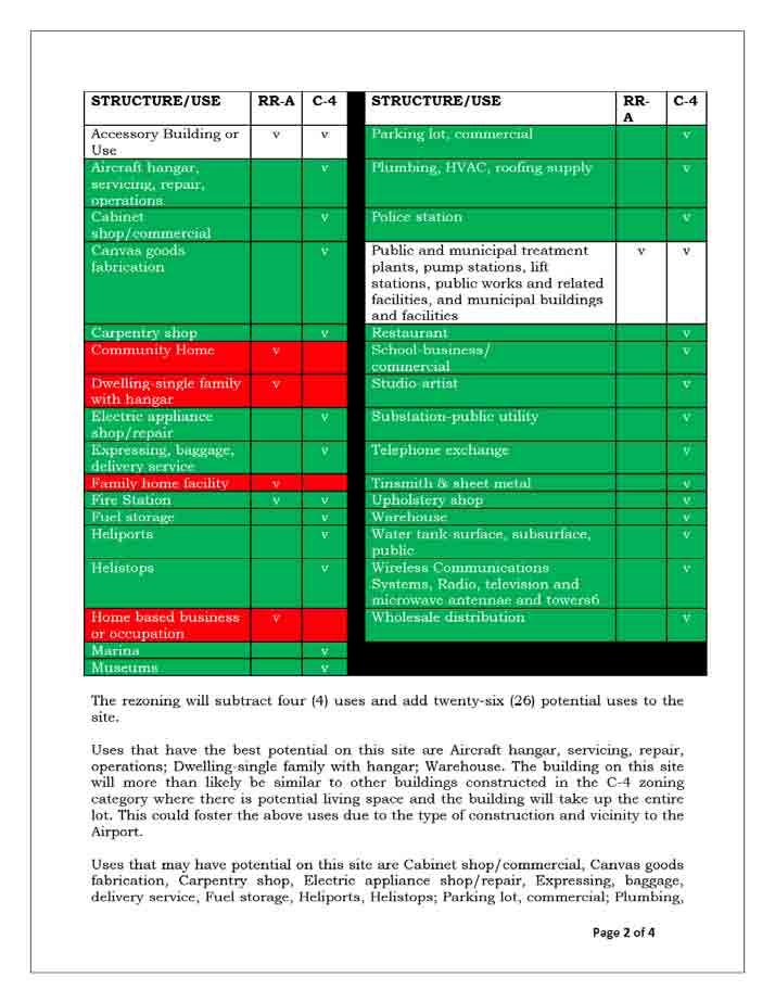
11 Development Services Department STAFF REPORT Application for Rezoning File Number: ZON-1043 Date: September 2, 2015 Applicant: Representative: Robert L. Wright SAME Hearing Dates: Planning & Zoning Commission September 10, 2015 City Council September 17, 2015 Location: 9211Bar K Ranch Rd. APPLICATION SUMMARY Consider adoption of Ordinance amending the official zoning map of approximately.52 acres of land, described as Bar K Estates, Plat 11, Lot 11331A, located at 9211 Bar K Ranch Rd., respectively, Lago Vista, Travis County, Texas, zoned Restricted - Single Family with Aircraft (RR-A) to Commercial Airport (C-4); providing a severability clause; and, providing an effective date. (Case No. ZON 1043) TECHNICAL REVIEW The Development Services Department has reviewed this request and there are no outstanding comments/issues. In the case that the rezoning is approved, all site engineering, drainage and required infrastructure improvements will be reviewed pursuant to the established Development Review Process to ensure that the Development has met all applicable Federal, State and local regulations and permitting requirements. No permits authorizing Development shall be issued prior to compliance with all applicable regulations. DEVELOPMENT REVIEW DEPARTMENT COMMENTS The current request to rezone to Commercial Airport (C-4) to allow for building of hanger with optional minimum living space located inside versus the current zoning which allows for a single family home with accessory hanger. Since the rezoning allows new uses, all these uses must be taken into consideration when determining compatibility with the area. On the next page is a list of all uses within the Restricted - Single Family with Aircraft (RR-A) and potential rezoned Commercial Airport (C-4), with RED being a subtracted use and GREEN being an added use: 11
12 12
13 HVAC, roofing supply, Restaurant, School-business/commercial, Tinsmith & sheet metal, Upholstery shop; Wholesale distribution. Although many commercial type uses are potentially possible at the site, there would be difficulties with starting many of these businesses. Most require delivery of materials to the site which would be made difficult due to the steepness of Bar K Ranch Rd. and Bison Trail. Another factor is there is little customer base for other uses which require customers. Uses not likely to have potential on this site are Fire Station, Museums, Police station, Studio-artist, Substation-public utility, Telephone exchange, Water tank-surface, subsurface, public; Wireless Communications Systems, Radio, television and microwave antennae and towers. There are no plans to expand police, fire, or other public utility services into that area due to lack of need. Other uses would not be compatible at the Airport due to height obstructions. The Lago Vista Comprehensive Master Plan has certain policies that may be used as criteria or guidance for a change in zoning. Following is a staff analysis with objectives in bold and staff comments in italics: Objective 3.19: With so little property currently zoned for nonresidential use, it is critical that additional land be zoned for nonresidential use. This sites potential rezoning will allow for more land area in conjunction with the current C-4 zoned land to the north (see attachment 3). Objective 5.11: Zone additional land and preserve for nonresidential land use. See answer to Objective Objective 5.13: Undeveloped land adjacent to the airport should be evaluated to determine potentially needed zoning changes to support additional nonresidential development. The present lot is undeveloped and adjacent to the Airport. Underlying land use is indicative of industrial uses for the lot. Although the zoning is not industrial in nature, a commercial use is closer to an industrial use than a residential use. Since the land use is Industrial and proposed rezoning is a commercial zoning these are not compatible. Although the City Code allows for a rezoning in this circumstance, it must meet the following additional requirements under Chapter 14, Section 13, Subsection 13.20(D). Below are the additional findings of fact (bold) and staff interpretation of those facts (in italics). (1) The Commission finds significant and unanticipated changes have occurred in the area of the affected parcel since the classification on the land use map was adopted. The area near the Airport has been zoned residential even though the land use is industrial, rezoning the land to C-4 is a commercial zoning that would better match the underlying land use. (2) It is unlikely that the parcel will be developed or used for any use permitted under the zoning classification indicated in the City s Master Plan. The underlying zoning of RR-A is a residential zoning that 13
14 allows for a single family home with an accessory hanger. This limits the likelihood of parcel development. The location near the airport should allow for the opportunity of additional Uses that utilize the Airport. (3) The Commission finds that the requested zoning classification is the most appropriate classification for the area affected. The underlying land use is indicative of industrial uses for the lot. Although the zoning is not industrial in nature, a commercial use is closer to an industrial use than a residential use. Council also approved a rezoning to the contiguous parcel to the north (Bar K Estates, Plat 11, Lot 11331A, located at 9207 Bar K Ranch Rd) at the August, 2015 meeting for the same zoning category. FINDINGS OF FACT Based on the planning file, staff report, and attachments associated with this packet staff believes this rezoning is not contrary to the public interest as required by Section 13.20(E)(3)(a) because the underlying land use is industrial which is indicative of a higher zoning category of commercial and the zoning to the immediate north is zoned C-4 (see attachment 3). Due to the location of the Airport, the uses listed within the C- 4 zoning category would also better accommodate the development pattern of the Airport. Several comprehensive plan objectives and additional findings of fact in Subsection 13.20(D) have been met in staff s professional opinion based on the documentation provided with the report. ATTACHMENTS Additional information is provided through attached exhibits. 1. Applicant Request 2. Proposed Ordinance 3. Maps 14
15 Attachment 1 Applicant Request 15
16 16
17 Attachment 2 Proposed Ordinance 17
18 ORDINANCE NO AN ORDINANCE OF THE CITY COUNCIL OF THE CITY OF LAGO VISTA, TEXAS, AMENDING THE OFFICIAL ZONING MAP BY REZONING BAR K ESTATES, PLAT 11, LOT 11331A FROM THE RR-A (RESTRICTED SINGLE FAMILY WITH AIRCRAFT) TO C-4 (COMMERCIAL AIRPORT) ZONING DISTRICT; AND PROVIDING FOR RELATED MATTERS. WHEREAS, the landowner of Lot 11331A, Plat 11, Bar K Estates ( Lot ) has filed an application requesting the City of Lago Vista ( City ) to consider rezoning such Lot from RR-A to C-4; and WHEREAS, after giving ten (10) days written notice to the owners of land in and within 200-feet of the area being rezoned, as well as having published notice to the public at least fifteen (15) days prior to the date of such hearing(s), the Planning and Zoning Commission and City Council each held a public hearing on the proposed re-zoning; and WHEREAS, the Planning and Zoning Commission (the Commission ) at its public hearing on the rezoning of such Lot, reviewed the request and the circumstances of the area being rezoned and finds that a substantial change in circumstances of the area being rezoned has transpired sufficient to warrant a change in the zoning; and and WHEREAS, the Commission recommends rezoning such Lot from RR-A to C-4; WHEREAS, the City Council at its public hearing on the rezoning, reviewed the request and the circumstances of the area and it concurs with the recommendation of the Commission; and WHEREAS, the City desires that development within its corporate limits occur in an orderly manner in order to protect the health, safety, and welfare of its present and future citizens, protect property values and provide for the growth of the City s tax base; and NOW, THEREFORE, BE IT ORDAINED BY THE CITY COUNCIL OF THE CITY OF LAGO VISTA, TEXAS, THAT: Section 1. Findings. The foregoing recitals are hereby found to be true and correct and are hereby adopted by the City Council and made a part hereof for all purposes as findings of fact. The Commission, City Manager and City Council find that this Ordinance satisfies the requirements of Section 13 of the City of Lago Vista Zoning Ordinance. Section 2. Amendment of Zoning Ordinance and Zoning Map. The Zoning Ordinance and the Official Zoning Map and other applicable ordinances are hereby 18
19 modified and amended by rezoning Bar K Estates, Plat 11, Lot 11331A, from RR-A to C-4. Section 3. Severability. Should any section or part of this Ordinance be held unconstitutional, illegal, or invalid, or the application to any person or circumstance for any reasons thereof ineffective or inapplicable, such unconstitutionality, illegality, invalidity, or ineffectiveness of such section or part shall in no way affect, impair or invalidate the remaining portion or portions thereof; but as to such remaining portion or portions, the same shall be and remain in full force and effect and to this end the provisions of this ordinance are declared to be severable. Section 4. Conflicting Ordinances. All ordinances or parts thereof conflicting or inconsistent with the provisions of this ordinance as adopted and amended herein, are hereby amended to the extent of such conflict. In the event of a conflict or inconsistency between this ordinance and any other code or ordinance of the city, the terms and provisions of this ordinance shall govern. Section 5. Effective Date. This Ordinance shall be in force and effect from and after its passage on the date shown below. Section 6. Open Meeting. It is hereby officially found and determined that this meeting was open to the public, and public notice of the time, place and purpose of said meeting was given, all as required by the Open Meetings Act, Chapt. 551, Tex. Gov't Code. PASSED AND APPROVED this 17 th day of September, ATTEST: Randy Kruger, Mayor Sandra Barton, City Secretary 19
20 Attachment 3 Maps 20
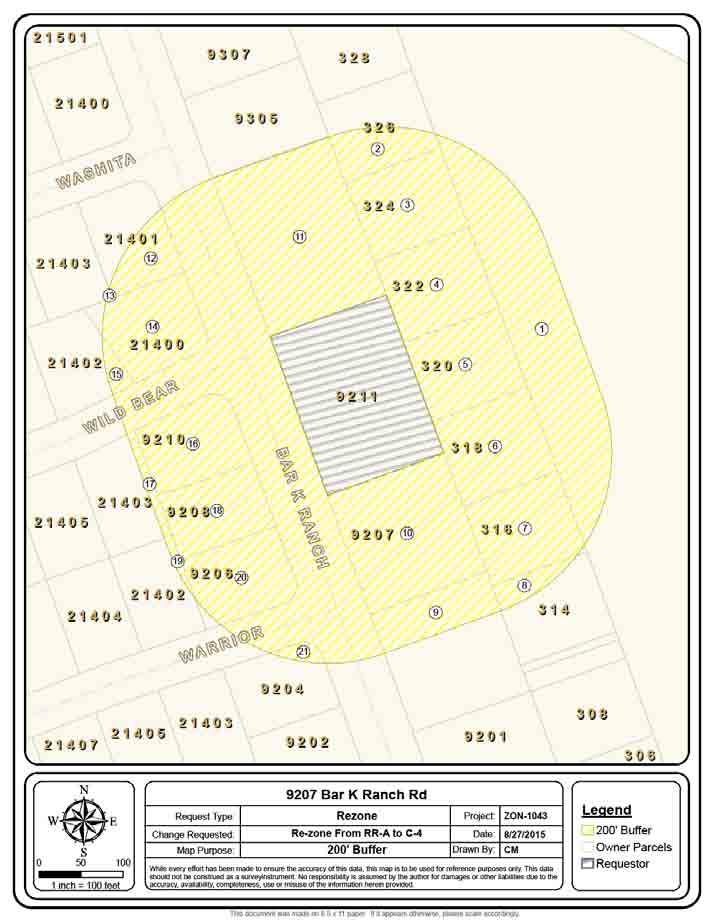
21 21
22 W A S H I T A W I L D B E A R W A R R I O R B A R K R A N C H inch = 100 feet Request Type: Change Requested: Map Purpose: 9207 Bar K Ranch Rd Rezone Re-zone From RR-A to C-4 Aerial & Topo Project: Date: Drawn By: ZON /27/2015 While every effort has been made to ensure the accuracy of this data, this map is to be used for reference purposes only. This data should not be construed as a surveyinstrument. No responsibility is assumed by the author for damages or other liabilities due to the accuracy, availability, completeness, use or misuse of the information herein provided. CM Legend 20' Contours Owner Parcels Requestor 22 This document was made on 8.5 x 11 paper. If it appears otherwise, please scale accordingly.
23 W A S H I T A W I L D B E A R B A R K R A N C H W A R R I O R inch = 100 feet Request Type: Change Requested: Map Purpose: 9207 Bar K Ranch Rd Rezone Re-zone From RR-A to C-4 Future Land Use Project: Date: Drawn By: ZON /27/2015 While every effort has been made to ensure the accuracy of this data, this map is to be used for reference purposes only. This data should not be construed as a surveyinstrument. No responsibility is assumed by the author for damages or other liabilities due to the accuracy, availability, completeness, use or misuse of the information herein provided. CM Legend Owner Parcels Requestor Future Land Use Low Density Residentia Commercial Industrial 23 This document was made on 8.5 x 11 paper. If it appears otherwise, please scale accordingly.
24 W A S H I T A W I L D B E A R B A R K R A N C H W A R R I O R inch = 100 feet Request Type: Change Requested: Map Purpose: 9207 Bar K Ranch Rd Rezone Re-zone From RR-A to C-4 Future Land Use Project: Date: Drawn By: ZON /3/2015 While every effort has been made to ensure the accuracy of this data, this map is to be used for reference purposes only. This data should not be construed as a surveyinstrument. No responsibility is assumed by the author for damages or other liabilities due to the accuracy, availability, completeness, use or misuse of the information herein provided. CM Legend Owner Parcels Requestor Zoning Class C-4 R-1A RR-A TR-1 24 This document was made on 8.5 x 11 paper. If it appears otherwise, please scale accordingly.
25 25
26 ORDINANCE NO AN ORDINANCE OF THE CITY COUNCIL OF THE CITY OF LAGO VISTA, TEXAS, AMENDING THE OFFICIAL ZONING MAP BY REZONING BAR K ESTATES, PLAT 11, LOT 11331A FROM THE RR-A (RESTRICTED SINGLE FAMILY WITH AIRCRAFT) TO C-4 (COMMERCIAL AIRPORT) ZONING DISTRICT; AND PROVIDING FOR RELATED MATTERS. WHEREAS, the landowner of Lot 11331A, Plat 11, Bar K Estates ( Lot ) has filed an application requesting the City of Lago Vista ( City ) to consider rezoning such Lot from RR-A to C-4; and WHEREAS, after giving ten (10) days written notice to the owners of land in and within 200-feet of the area being rezoned, as well as having published notice to the public at least fifteen (15) days prior to the date of such hearing(s), the Planning and Zoning Commission and City Council each held a public hearing on the proposed re-zoning; and WHEREAS, the Planning and Zoning Commission (the Commission ) at its public hearing on the rezoning of such Lot, reviewed the request and the circumstances of the area being rezoned and finds that a substantial change in circumstances of the area being rezoned has transpired sufficient to warrant a change in the zoning; and and WHEREAS, the Commission recommends rezoning such Lot from RR-A to C-4; WHEREAS, the City Council at its public hearing on the rezoning, reviewed the request and the circumstances of the area and it concurs with the recommendation of the Commission; and WHEREAS, the City desires that development within its corporate limits occur in an orderly manner in order to protect the health, safety, and welfare of its present and future citizens, protect property values and provide for the growth of the City s tax base; and NOW, THEREFORE, BE IT ORDAINED BY THE CITY COUNCIL OF THE CITY OF LAGO VISTA, TEXAS, THAT: Section 1. Findings. The foregoing recitals are hereby found to be true and correct and are hereby adopted by the City Council and made a part hereof for all purposes as findings of fact. The Commission, City Manager and City Council find that this Ordinance satisfies the requirements of Section 13 of the City of Lago Vista Zoning Ordinance. Section 2. Amendment of Zoning Ordinance and Zoning Map. The Zoning Ordinance and the Official Zoning Map and other applicable ordinances are hereby 26
27 modified and amended by rezoning Bar K Estates, Plat 11, Lot 11331A, from RR-A to C-4. Section 3. Severability. Should any section or part of this Ordinance be held unconstitutional, illegal, or invalid, or the application to any person or circumstance for any reasons thereof ineffective or inapplicable, such unconstitutionality, illegality, invalidity, or ineffectiveness of such section or part shall in no way affect, impair or invalidate the remaining portion or portions thereof; but as to such remaining portion or portions, the same shall be and remain in full force and effect and to this end the provisions of this ordinance are declared to be severable. Section 4. Conflicting Ordinances. All ordinances or parts thereof conflicting or inconsistent with the provisions of this ordinance as adopted and amended herein, are hereby amended to the extent of such conflict. In the event of a conflict or inconsistency between this ordinance and any other code or ordinance of the city, the terms and provisions of this ordinance shall govern. Section 5. Effective Date. This Ordinance shall be in force and effect from and after its passage on the date shown below. Section 6. Open Meeting. It is hereby officially found and determined that this meeting was open to the public, and public notice of the time, place and purpose of said meeting was given, all as required by the Open Meetings Act, Chapt. 551, Tex. Gov't Code. PASSED AND APPROVED this 17 th day of September, ATTEST: Randy Kruger, Mayor Sandra Barton, City Secretary 27
28 AGENDA ITEM City of Lago Vista To: Mayor & City Council Council Meeting: September 17, 2015 From: Melissa Byrne Vossmer, City Manager Subject: Conduct the Second Public Hearing on the Proposed FY15/16 Budget. Request: Public Hearing Legal Document: Other Legal Review: EXECUTIVE SUMMARY: The process a city must follow to set the Tax Rate and Adopt the budget is governed by State Law as well as the City's Charter. Pursuant to Tax Code 26.05, the Council may not adopt a tax rate that exceeds the lower of the rollback tax rate or the effective tax rate until the Governing Body has held two public hearings. While no decision has been made by the Council on the tax rate for the FY15/16 Budget, these public hearings were included in the budget adoption process to provide maximum flexibility in the decision making process. As this process moves forward, the Council cannot set a tax rate greater than $ 0.65 / $100 which is the current tax rate. As Council will recall, the process this year was impacted by the significant delay in receiving the Truth in Taxation calculations from Travis County. The two public hearings, properly noticed, were scheduled for Thursday, September 10, 2015 at 4:30 p.m. in the Council Chambers at City Hall and Thursday, September 17, 2015 at 6:30 p.m. in the Council Chambers at City Hall. Last week, the Council did conduct the first public hearing in conjunction with a Special Council Meeting. Council also discussed other FY15/16 Budget related items that required Council direction to begin to finalize the budget as it pertains to water / wastewater and the updated Fiscal & Budgetary Policy Statement. The second Public Hearing is part of the Regular Council Meeting or September 17, Once the Public Hearing is concluded, the Council must announce the date, time and place of the Council meeting at which it will vote on the proposed tax rate. Council has discussed scheduling that Council meeting for Tuesday, September 29, 2015, time still to be determined, in the Council Chambers at City Hall,
29 Thunderbird St., Lago Vista, TX Once this date / time is set, Staff must publish notice of the Special Council Meeting. As directed by Council, there is a companion item on the agenda to provide the opportunity for Council to continue its' discussion on the FY15/16 Budget. Impact if Approved: Impact if Denied: Is Funding Required? Yes No If Yes, Is it Budgeted? Yes No N/A Indicate Funding Source: Suggested Motion/Recommendation/Action Motion to: Approve Item Motion to: Motion to: Known As: 2nd Public Hearing on the 2015 Tax Rate for the City of Lago Vista. 29
30 Agenda Item Approved by City Manager 30
31 31
32 32
33 33
34 34
35 35
36 36
37 37
38 38
39 39
40 40
41 41
42 42
43 43
44 44
45 45
46 46
47 47
48 AGENDA ITEM City of Lago Vista To: Mayor & City Council Council Meeting: September 17, 2015 From: David Harrell, AICP, Director Subject: Ordinance , an Ordinance of the City Council of the City of Lago Vista, Texas approving an annual service and assessment plan (SAP) update and amendment to the SAP for the Tessera on Lake Travis Public Improvement District (PID) Request: Public Hearing Legal Document: Ordinance Legal Review: EXECUTIVE SUMMARY: The City Council originally approved a Service and Assessment Plan (SAP) with the Tessera on Lake Travis PID. Under Section of the Texas Local Government Code the SAP must reviewed and updated annually for the purpose of determining the annual budget of the improvements. This review must take place by the governing body (City Council). Staff has provided portions of the 2014 SAP highlighting the changes between last years approved document and this years proposed document. These portions are included as an attachment at the end. The 2014 page numbers correspond to the 2015 page numbers. Please examine both carefully. Representatives from DPFG (our financial consultants) will be present to provide additional information and address Council questions. 48
49 Impact if Approved: SAP will be in compliance with State law regarding required annual update. Impact if Denied: SAP will NOT be in compliance with State law regarding required annual update. Is Funding Required? Yes No If Yes, Is it Budgeted? Yes No N/A Indicate Funding Source: N/A Suggested Motion/Recommendation/Action Motion to: Motion to: Motion to: Enact Ordinance Deny Ordinance Table Ordinance Known As: the 2015 annual update to the Tessera on Lake Travis Service & Assessment Plan. Agenda Item Approved by City Manager 49
50 ORDINANCE NO AN ORDINANCE OF THE CITY COUNCIL OF THE CITY OF LAGO VISTA, TEXAS APPROVING AN ANNUAL SERVICE PLAN UPDATE TO THE SERVICE AND ASSESSMENT PLAN FOR THE TESSERA ON LAKE TRAVIS PUBLIC IMPROVEMENT DISTRICT THE STATE OF TEXAS COUNTY OF TRAVIS CITY OF LAGO VISTA WHEREAS, the City of Lago Vista, Texas (the "City") is authorized under Chapter 372 of the Texas Local Government Code, as amended (the "Act"), to create a public improvement district; WHEREAS, after providing all notices, holding all public hearings and complying with all prerequisites required by the Act and otherwise required by the laws of the State of Texas, the City Council of the City (the "City Council") created a public improvement district known as the Tessera on Lake Travis Public Improvement District (the "District"); WHEREAS, on November 1, 2012, the City Council passed and adopted Ordinance No (the "Assessment Ordinance") levying special assessments for platted land within the District (the "Assessed Property"), approving a service and assessment plan for the platted land (the "Original Service and Assessment Plan") attached as Exhibit A to the Assessment Ordinance, and approving an assessment roll for such platted land within the District; WHEREAS, the Original Service and Assessment Plan is required to be reviewed and updated annually for the purpose of determining the annual budget for improvements in the District and the assessment for each property owner may be adjusted as that time; and WHEREAS, there has been presented to the City Council an update to the Original Service and Assessment Plan (the "SAP Update" and, together with the Original Service and Assessment Plan, the "Service and Assessment Plan") which identifies the portion of the District constituting the Major Improvement Area of the District (the "Major Improvement Area") and Improvement Area #1 of the District (the "Improvement Area #1") and identifying costs of the Major Improvement Area improvements and Improvement Area #1 improvements within the District, and updating the assessment roll for the assessed property in the District. NOW, THEREFORE, BE IT ORDAINED BY THE CITY COUNCIL OF THE CITY OF LAGO VISTA, TEXAS: Section 1. All matters stated in the preamble of this Ordinance are found to be true and correct and are incorporated into the body of this Ordinance as if copied in their entirety. Section 2. The SAP Update in substantially the form and content attached as Exhibit "A" hereto is hereby approved. Section 3. The improvements benefitting and serving all of the property within the portion of the District identified as the Major Improvement Area are set forth in Section III-A of 50
51 the SAP Update. The major improvements other than the major improvements allocable to Improvement Area #1 are referred to herein as the "Major Improvement Area Improvements." Improvements that will benefit and serve only the property within Improvement Area # 1 are set forth in Section III-B of the SAP Update. The major improvements allocable to Improvement Area #1 and the improvements that benefit and serve only the property within Improvement Area #1 are referred to herein as the "Improvement Area #1 Improvements." Section 4. The City Council hereby finds and determines that: (i) the enhancement and value to accrue to the Major Improvement Area and Improvement Area #1 and the real and true owner or owners thereof by virtue of construction of the Major Improvement Area Improvements and Improvement Area #1 Improvements will be equal to or in excess of the amount of the costs of the improvements; (ii) that the apportionment of the costs of the Major Improvement Area Improvements and the Improvement Area #1 Improvements and the assessments here and below made are just and equitable and produce substantial equality, considering the benefits received and the burdens imposed thereby, and result in imposing equal shares of the cost of the Major Improvement Area Improvements and the Improvement Area #1 Improvements on property similarly benefitted, and are in accordance with the laws of the State of Texas; (iii) the property assessed is specially benefitted by means of the said Major Improvement Area Improvements and Improvement Area #1 Improvements in the District in relation to the costs of such improvements; (iv) all procedures that have taken place heretofore with reference to the Major Improvement Area Improvements and Improvement Area #1 Improvements assessments are in all respects regular, proper, and valid; and (v) all prerequisites to the fixing of the assessment liens against the properties within the Major Improvement Area and Improvement Area #1, and the personal liability of the real and true owner or owners thereof, whether correctly named herein or not, have been in all things regularly and duly performed in compliance with the Act and the proceedings of the City Council. Section 5. This ordinance incorporates by reference all provisions and requirements of the Act. Section 6. If any section, article, paragraph, sentence, clause, phrase, or word in this Ordinance, or application thereof to any persons or circumstances is held invalid or unconstitutional by a court of competent jurisdiction, such holding shall not affect the validity of the remaining portions of this Ordinance; and the City Council hereby declares it would have passed such remaining portion of this Ordinance, despite such invalidity, which remaining portions shall remain in full force and effect. Section 7. This Ordinance shall take effect immediately from and after its passage and it is accordingly so ordained. (Execution Page Follows) 51
52 PASSED, APPROVED AND ADOPTED on the 20 th day of August, CITY OF LAGO VISTA, TEXAS Randy Kruger, Mayor ATTEST: Sandra Barton, City Secretary 52
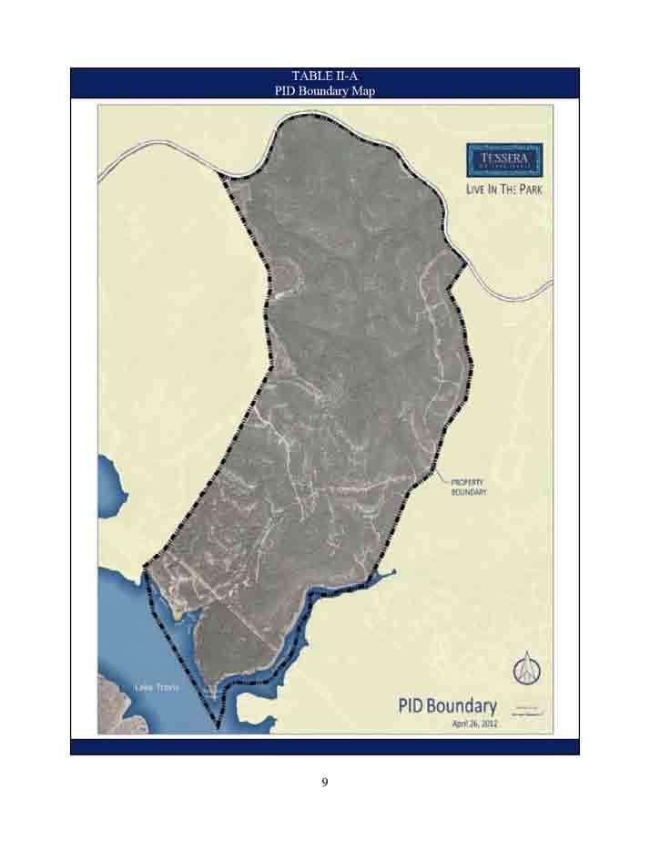
53 53
54 Section I PLAN DESCRIPTION AND DEFINED TERMS A. Introduction On August 16, 2012, (the Creation Date ) the Lago Vista City Council approved that certain Petition for the Creation of a Public Improvement District to Finance Improvements for the Tessera On Lake Travis Subdivision which authorized the creation of the Tessera On Lake Travis Public Improvement District (the PID ) to finance the Actual Costs for the benefit of certain property in the PID, all of which is located in the corporate limits of Lago Vista, Texas (the City ). Upon application of the current property owners, the property within the PID was zoned by Ordinance No (the Planned Development District Ordinance ) adopted by the City of Lago Vista on December 17, The Planned Development District Ordinance was amended by Ordinance No and designates the type of land uses that are permitted within the project and include development standards for each land use type. Chapter 372 of the Texas Local Government Code, Improvement Districts in Municipalities and Counties (as amended, the PID Act ), governs the creation of public improvement districts within the State of Texas. This Service and Assessment Plan has been prepared pursuant to the PID Act. According to the PID Act, a service plan must cover a period of five years and must also define the annual indebtedness and the projected costs for improvements. The plan shall be reviewed and updated annually for the purpose of determining the annual budget for improvements. The service plan is described in Section V of this Service and Assessment Plan. The Assessment Roll for the Major Improvement Area is attached hereto as Appendix A and the Assessment Roll for Improvement Area #1 is attached hereto as Appendix B, both of which are addressed in Section VII of this Service and Assessment Plan. The Assessments as shown on the Assessment Roll are based on the method of assessment described in Sections IV and VI of this Service and Assessment Plan. B. Definitions Capitalized terms used herein shall have the meaning ascribed to them as follows: Actual Cost(s) means, with respect to an Authorized Improvement, the demonstrated, reasonable, allocable, and allowable costs of constructing such Authorized Improvement, as specified in a Certification for Payment that has been reviewed and approved by the City. Actual Cost may include (a) the costs for the design, planning, financing, administration, management, acquisition, installation, construction and/or implementation of such Authorized Improvement, including general contractor construction management fees, if any, (b) the costs of preparing the construction plans for such Authorized Improvement, (c) the fees paid for obtaining permits, licenses or other governmental approvals for such Authorized Improvement, (d) the costs for external professional costs associated with such Authorized Improvement, such as engineering, geotechnical, surveying, land planning, architectural landscapers, advertising, marketing and research studies, appraisals, legal, accounting and similar professional services, taxes (property 2 54
55 and franchise) (e) the costs of all labor, bonds and materials, including equipment and fixtures, incurred by contractors, builders and materialmen in connection with the acquisition, construction or implementation of the Authorized Improvements, (f) all related permitting, zoning and public approval expenses, architectural, engineering, legal, and consulting fees, financing charges, taxes, governmental fees and charges (including inspection fees, County permit fees, development fees), insurance premiums, miscellaneous expenses, and all advances and payments for Administrative Expenses. Actual Costs shall not include general contractor s fees in an amount that exceeds a percentage equal to the percentage of work completed and accepted by the City or construction management fees in an amount that exceeds 5.0% of the eligible Actual Costs described in a Certification for Payment. The amounts expended on legal costs, taxes, governmental fees, insurance premiums, permits, financing costs, and appraisals shall be excluded from the base upon which the general contractor and construction management fees are calculated. Actual Costs also may be paid to the Developer or any other person or entity only in the capacity of construction manager or only in the capacity of general contractor but not both. Administrator means an employee or designee of the City who shall have the responsibilities provided for herein, in the Indenture related to the Bonds, or in another agreement approved by the City Council. Administrative Expenses mean the administrative, organization, maintenance and operation costs associated with, or incident to, the administration, organization, maintenance and operation of the PID, including, but not limited to, the costs of: (i) creating and organizing the PID, including conducting hearings, preparing notices and petitions, and all costs incident thereto, including engineering fees, legal fees and consultant fees, (ii) the annual administrative, organization, maintenance, and operation costs and expenses associated with, or incident and allocable to, the administration, organization, and operation of the PID, (iii) computing, levying, billing and collecting Special Assessments or the installments thereof, (iv) maintaining the record of installments of the Special Assessments and the system of registration and transfer of the Bonds, (v) paying and redeeming the Bonds, (vi) investing or depositing of monies, (vii) complying with the PID Act and the Code with respect to the Bonds, (viii) the Trustee fees and expenses relating to the Bonds, including reasonable fees, (ix) legal counsel, engineers, accountants, financial advisors, investment bankers or other consultants and advisors, and (x) administering the construction of the Authorized Improvements. Administrative Expenses do not include payment of the actual principal of, redemption premium, if any, and interest on the Bonds. Administrative Expenses collected and not expended for actual Administrative Expenses shall be carried forward and applied to reduce Administrative Expenses in subsequent years to avoid the over-collection of Administrative Expenses. Annual Installment means, with respect to each Assessed Property, each annual payment of: (i) the Assessment, as shown on the Assessment Roll attached hereto as Appendix A or Appendix B, as applicable, or in an Annual Service Plan Update, and calculated as provided in Section VI of this Service and Assessment Plan, (ii) Administrative Expenses, (iii) the prepayment reserve described in Section IV of this Service and Assessment Plan, and (iv) the delinquency reserve described in Section IV of this Service and Assessment Plan. Annual Service Plan Update has the meaning set forth in Section V of this Service and Assessment Plan. 3 55
56 Assessed Property means, for any year, Parcels within the PID other than Non-Benefited Property. Assessment means the assessment levied against a Parcel imposed pursuant to the Assessment Ordinance and the provisions herein, as shown on the Assessment Roll, subject to reallocation upon the subdivision of such Parcel created by such subdivision or reduction according to the provisions hereof and the PID Act. Assessment Ordinance means each ordinance adopted by the City Council approving the Service and Assessment Plan (including amendments or supplements to the Service and Assessment Plan) and levying the Assessments. Assessment Revenues mean the revenues actually received by the City from Assessments. Assessment Roll means, as applicable, the Major Improvement Area Assessment Roll and the Improvement Area #1 Assessment Roll or any other Assessment Roll in an amendment or supplement to this Service and Assessment Plan or in an Annual Service Plan Update. Authorized Improvements mean those public improvements described in Section of the PID Act designed, constructed, and installed in accordance with this Service and Assessment Plan, and any future amendments. Bonds mean any bonds secured by all or a portion of the Assessment Revenues issued by the City in one or more series. Certification for Payment means the document to be provided by the Developer or construction manager to substantiate the Actual Cost of one or more Authorized Improvements. City means the City of Lago Vista, Texas. City Council means the duly elected governing body of the City. Delinquent Collection Costs mean interest, penalties and expenses incurred or imposed with respect to any delinquent installment of an Assessment in accordance with the PID Act and the costs related to pursuing collection of a delinquent Assessment and foreclosing the lien against the Assessed Property, including attorney s fees. Developer means Hines Lake Travis Land Limited Partnership, a Texas Domestic Limited Partnership, and Hines Lake Travis Land II Limited Partnership, a Texas Domestic Limited Partnership, or their assignees or successors. Future Improvement Area means Improvement Areas that are developed after Improvement Area #1, as such areas are generally shown on Table II-C. The Future Improvement Areas are subject to adjustment and are shown for example only. 4 56
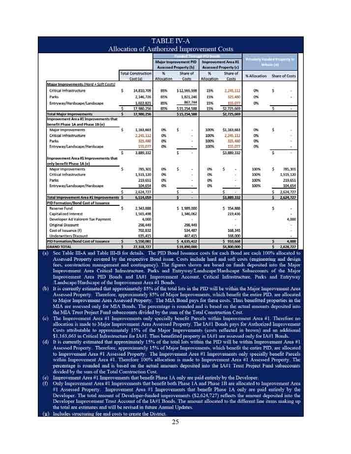
57 Homeowner Association Property means property within the boundaries of the PID that is owned by or irrevocably offered for dedication to, whether in fee simple or through an exclusive use easement, a home owners association established for the benefit of a group of homeowners or property owners within the PID. Improvement Area means one or more Parcels within the PID that will be developed in the same general time period. The Parcels within an Improvement Area will be assessed in connection with the issuance of Phased PID Bonds for Authorized Improvements (or the portion thereof) designated in an update to this Service and Assessment Plan that specially benefit the Parcels within the Improvement Area. Improvement Area #1 means the initial Improvement Area to be developed, identified as Phase 1 PID and generally shown on Table II-B and as specifically depicted and described as the sum of all Parcels shown in Appendix F. Improvement Area #1 Assessed Property means all Parcels within Improvement Area #1 other than Non-Benefited Property. Improvement Area #1 Assessment Roll means the document included in this Service and Assessment Plan as Appendix B, as updated, modified or amended from time to time in accordance with the procedures set forth herein and in the PID Act, including updates prepared in connection with the issuance of Bonds or in connection with any Annual Service Plan Update. Improvement Area #1 Improvements means Authorized Improvements which only benefit Improvement Area #1 Assessed Property and are described in Section III. C. Indenture means any indenture, trust agreement, ordinance, or similar document setting forth the terms and provisions relating to any series of Bonds, as may be amended or supplemented. Improvement Area #1 PID Bonds means those certain City of Lago Vista, Texas Special Assessment Revenue Bonds, Series 2012 (Tessera On Lake Travis Public Improvement District Improvement Area #1 Project) that are secured by Assessments levied on Improvement Area #1 Assessed Property. Landowner s Agreement means that certain Landowner Agreement by and between the City and Developer whereby Developer grants its consent for Assessments to be levied on the property within the PID, in addition to other matters. Lot means a tract of land described as a lot in a subdivision plat recorded in the Official Public Records of Travis County, Texas. Lot Type means a classification of final building lots with similar characteristics (e.g. commercial, light industrial, multifamily residential, single family residential, etc.), as determined by the Administrator and confirmed by the City Council. In the case of single family residential Lots, the Lot Type shall be further defined by classifying the residential lots by the estimated final Lot value for each lot as of the date of the recorded subdivision plat, considering factors such as density, lot size, proximity to amenities, view premiums, location, and any other factors that may impact Lot value, as determined by the Administrator and confirmed by the City Council. 5 57
58 Major Improvements means Authorized Improvements which benefit all Assessed Property within the PID and are described in Section III. B. Major Improvement Area means the property within the PID not within Improvement Area #1, as generally shown on Table II-B and as specifically depicted and described as the sum of all Parcels shown in Appendix E. Major Improvement Area Assessed Property means, for any year, all Parcels within the PID other than Non-Benefited Property and Improvement Area #1 Assessed Property. Major Improvement Area Assessment Roll means the document included in this Service and Assessment Plan as Appendix A, as updated, modified or amended from time to time in accordance with the procedures set forth herein and in the PID Act, including updates prepared in connection with the issuance of Bonds or in connection with any Annual Service Plan Update. Major Improvement Area Bonds means those certain City of Lago Vista, Texas Special Assessment Revenue Bonds, Series 2012 (Tessera On Lake Travis Public Improvement District Major Improvement Area Project) that are secured by Assessments levied on Major Improvement Area Assessed Property. Non-Benefited Property means Parcels within the boundaries of the PID that accrue no special benefit from the Authorized Improvements as determined by the City Council, including Homeowner Association Property and Public Property. Property identified as Non-Benefited Property at the time the Assessments (i) are levied or (ii) are reallocated pursuant to a subdivision of a Parcel is not assessed. Assessed Property converted to Non-Benefited Property, if the Assessments may not be reallocated pursuant to Section VI.F, remains subject to the Assessments and requires the Assessments to be prepaid as provided for in Section VI.F. Restated Development Agreement means the restated development agreement between the Developer and the City having an effective date of August 16, Parcel means a property identified by either a tax map identification number assigned by the Travis Central Appraisal District for real property tax purpose, by metes and bounds description, by lot and block number in a final subdivision plat recorded in the Official Public Records of Travis County, or by any other means determined by the City. Phase 1A means the area contained in Improvement Area #1 that is expected to contain 210 single family residential units, as shown in Appendix I. Phase 1B means the area contained in Improvement Area #1 that is expected to contain 106 single family residential units, as shown in Appendix J. Phased PID Bonds means bonds issued to fund Authorized Improvements (or a portion thereof) in an Improvement Area and to refinance any Major Improvement Area Bonds issued to fund Major Improvements within such Improvement Area. In connection with the Phased PID Bonds, Assessments will be levied only on Parcels located within the Improvement Area in question. 6 58
59 Phased PID Bond Authorized Improvements means those Authorized Improvements associated with any given Improvement Area and contained in any supplemental table referred to in Section III.D and IV.E hereof. PID Act means Texas Local Government Code Chapter 372, Improvement Districts in Municipalities and Counties, Subchapter A, Public Improvement Districts, as amended. PID means the Tessera on Lake Travis Public Improvement District created by the City pursuant to Resolution No Planned Development District Ordinance has the meaning set forth in Section I.A of this Service and Assessment Plan. Prepayment Costs mean interest and expenses to the date of prepayment (or in the case of capital appreciation bonds, the accreted value on the date of prepayment), plus any additional amounts due pursuant to the Indenture related to the Bonds and allowed by law, if any, reasonably expected to be incurred by or imposed upon the City as a result of any prepayment of an Assessment and the Bonds secured by such Assessment. Property has the meaning set forth in Section II.A of this Service and Assessment Plan. Public Property means property, real property, right of way and easements located within the boundaries of the PID that is owned by or irrevocably offered for dedication to the federal government, the State of Texas, Travis County, the City, a school district, a public utility provider or any other political subdivision or public agency, whether in fee simple, through an exclusive use easement, or through a public utility easement. Service and Assessment Plan means this Service and Assessment Plan prepared for the PID pursuant to the PID Act, as the same may be amended from time to time. Tessera on Lake Travis means the approximately 877 acres of land located in Travis County, Texas, contained within the area described on Table II-A. Tessera on Lake Travis is located in the City s corporate limits. 7 59
60 Section II PROPERTY INCLUDED IN THE PID A. Property Included in the PID The area constituting the PID is depicted and described by metes and bounds on Exhibit A to Resolution No adopted by the City Council ( Property ). The PID is located in the corporate limits of the City of Lago Vista, Texas, within Travis County, Texas. The PID contains approximately acres. A map of the property within the PID is shown in Table II-A. At completion, the PID is expected to consist of approximately 2,000 detached single family residential units, multifamily units, office, and retail uses, as well as parks, entry monuments, and associated rights-of-way, landscaping, and infrastructure necessary to provide roadways, drainage, and utilities to the PID. The estimated number of lots and the classification of each lot are based upon the Planned Development District Ordinance. 8 60
61 61
62 62
63 63
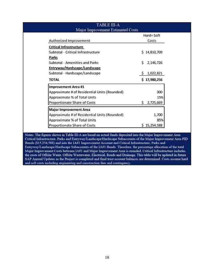
64 Section III DESCRIPTION OF THE AUTHORIZED IMPROVEMENTS A. Authorized Improvement Overview Section of the PID Act defines the Authorized Improvements that may be undertaken by a municipality or county through the establishment of a public improvement district. Authorized Improvements that may be undertaken pursuant to the PID Act include the following: (i) landscaping; (ii) erection of fountains, distinctive lighting, and signs; (iii) acquiring, constructing, improving, widening, narrowing, closing, or rerouting of sidewalks or of streets, any other roadways, or their rights-of way; (iv) construction or improvement of pedestrian mall; (v) acquisition and installment of pieces of art; (vi) acquisition, construction or improvement of libraries; (vii) acquisition, construction or improvement of off-street parking facilities; (viii) acquisition, construction or improvement of rerouting of mass transportation facilities; (ix) acquisition, construction or improvement of water, wastewater, or drainage facilities or improvements; (x) the establishment or improvement of parks; (xi) projects similar to those listed in Subdivisions (i)-(x) (xii) acquisition, by purchase or otherwise, of real property in connection with an authorized improvement; (xiii) special supplemental services for improvement and promotion of the district, including services relating to advertising, promotion, health and sanitation, water and wastewater, public safety, security, business recruitment, development recreation and cultural enhancement; and (xiv) payment of expenses incurred in the establishment, administration and operation of the district. After analyzing the public improvement projects authorized by the PID Act, the City has determined that the Authorized Improvements described in Section III.B and Section III.C of this Service and Assessment Plan should be undertaken by the City. B. Descriptions and Estimated Costs of Major Improvements The Major Improvements benefit the entire PID. However, Major Improvement Area Assessed Property does not include Improvement Area #1 Assessed Property; therefore the costs of the Major Improvements are allocated proportionally between Major Improvement Area Assessed Property and Improvement Area #1 Assessed Property based on the projected number of residential units within their respective boundaries. Improvement Area #1 is projected to contain approximately 300 residential units and the Major Improvement Area is projected to contain approximately 1,700 residential units within their respective boundaries, resulting in approximately 15% of the Major Improvements allocated to Improvement Area #1 Assessed 12 64
65 Property and approximately 85% to Major Improvement Area Assessed Property. Major Improvement Area Bonds will fund the Major Improvement Area s proportionate share of the costs of the Major Improvements, and Improvement Area #1 Bonds will fund the Improvement Area #1 s proportionate share of the costs of the Major Improvements. The Major Improvements are described below. The costs of the Major Improvements are shown in Table III-A. The costs shown in Table III-A are estimates and may be revised in Annual Service Plan Updates. Water o Water Treatment Plant #1 Upgrades The Lago Vista Water Treatment Plant No. 1 (WTP) will be upgraded for the first phase of 490 Living Unit Equivalents (LUE s) by adding two pumps next to the existing booster pump building at WTP; minimum capacity of each pump is 500 gpm; a scada system and control valves at City WTP. The upgrades will include limited site work, pumping equipment, piping, and electrical equipment improvements. Under the Restated Development Agreement these WTP upgrades will be constructed to City standards and specifications and will be owned and operated by the City. o Water Line 1 This project consists of constructing approximately 9,000 linear feet of 12 diameter water transmission main from the WTP. The project will be constructed within the existing right of way (ROW) of Seminole Drive, Clubhouse Drive, Bonanza Drive, Canyon Drive, Dawn Drive, Valleyview Drive, Park Drive, Verde Vista Drive and Brewer Lane and will end at the intersection of Brewer Lane and Deepwood Drive. The line will be designed and constructed in accordance with City of Lago Vista standards and specifications and will be owned and operated by the City. The line will have all the necessary appurtenances to be a fully operational transmission main. The line will provide service to Tessera on Lake Travis. o Water Line 2 This project consists of constructing approximately 8,000 linear feet of 14 diameter water transmission mains from a connection point in Water Line 1 at Brewer Lane and Deepwood Drive. The project will be constructed within the existing right of way (ROW) of Deepwood Drive, Ridgeview Road, Packsaddle Trail, Stable Lane, Bar-K-Ranch Road, Surrey Lane and include a 14 diameter water transmission main and a 16 diameter water transmission main crossing Lake Travis through Turnback Cove onto Tessera on Lake Travis. The line will be designed and constructed in accordance with City of Lago Vista standards and specifications and will be owned and operated by the City. The line will have all the necessary appurtenances to be fully operational transmission main. The line will provide service to Tessera on Lake Travis
66 o Water Line 3 This project consists of constructing approximately 1,000 linear feet of 14 diameter water transmission mains from a connection point in Water Line 2 at the westernmost point of Turnback Cove. The project will be constructed within an easement to the new right of way (ROW) of Burnet Route Trail and will tie into Water Line 1. The line will be designed and constructed in accordance with City of Lago Vista standards and specifications and will be owned and operated by the City. The line will have all the necessary appurtenances to be fully operational transmission main. The line will provide service to Tessera on Lake Travis. o Water Line 4 This project consists of constructing approximately 4,100 linear feet of 12 diameter water transmission mains from a connection point in Water Line 3 and then constructed within the new right of way (ROW) of Burnet Route Trail to the Tessera West Ground Storage Tank site described in the Restated Development Agreement. The line will be designed and constructed in accordance with City of Lago Vista standards and specifications and will be owned and operated by the City. The line will have all the necessary appurtenances to be fully operational transmission main. The line will provide service to Tessera on Lake Travis. o Ground Storage Tank The Ground Storage Tank (GST) shall be new construction onsite at the Tessera West Ground Storage Tank site described in the Restated Development Agreement on Lake Travis Water for a 125,000 gallon water capacity and include chlorination equipment and pump house to meet design requirements per the City of Lago Vista. Under the Restated Development Agreement this GST will be constructed to City standards and specifications and will be owned and operated by the City. Wastewater o Wastewater Treatment Plant Improvements This project will consist of cost participating with the City of Lago Vista on constructing a force main header to combine multiple force mains entering City s Wastewater Treatment Plant, as described in the Restated Development Agreement. o Wastewater Lines 1 and 2 This project will consist of over-sizing the force main from the Hollows, increase the force main to 14-inch in diameter for approximately 2,000 linear feet and 18-inches in diameter for approximately 1,650 linear feet. This project will tie into and utilize the City s existing 12-inch wastewater force main from existing Bar-K Lift Station to Turner s Lift Station and tie into and utilize the City s existing 8-inch wastewater force main in Bar-K Ranch Road. o Lift Station Pump Upgrades This project will consist of upgrading the existing Bar-K Wastewater Lift Station and the Turner Lift Station with increased pump capacity, add odor control and add scada control
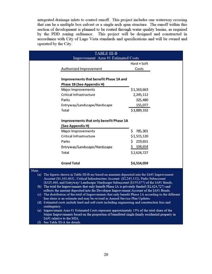
67 o Wastewater Line 3 This project will consist of constructing an 8-inch HDPE force main approximately 6,500 l.f. from Tessera on Lake Travis to the City s 8-inch force main in Bar-K Ranch Road. (WW-1.6-8" HDPE Force Mains in existing asphalt streets). o Wastewater Line 4 This project will consist of constructing 3-8 HDPE low pressure wastewater force mains at the crossing of Turnback Cove into Tessera on Lake Travis and then continuing one of these force mains into Tessera on Lake Travis terminating at Burnet Route Trail. This project will also consist of constructing a multiple HDPE force mains connected to one of the Wastewater Line 4 force mains at the Turnback Cove crossing into Tessera on Lake Travis. This line will be designed and constructed in accordance with City of Lago Vista standards and specifications. These lines will have all the necessary appurtenances to be fully operational sewer mains. All wastewater projects will be constructed to City standards and specifications and will be owned and operated by the City. Electrical o Electrical Infrastructure The electrical costs are comprised of infrastructure materials and installation expenditures, collectively, the Improvements. The material components consist of electrical vaults, primary cables, primary connections, URD conductors, and infrastructure conduit. Installation components consist of trenching, labor and equipment. The Improvements provide electrical power to all entryway features, on site lift station, the Community Pool and Pavilion, landscape irrigation systems and will support decorative street lighting improvements. The associated Improvements are in excess of 12,100 linear feet of primary cable, over 33,800 linear feet of conduit, seven major electrical vaults and multiple primary connections. Roadway o TxDOT Turn Lane Project shall consist of funding the construction of approximately 1300 linear feet (LF) of the Texas Department of Transportation ( TxDOT ) highway in the right of way (ROW) for east bound traffic and conversion of existing traffic lane for eastbound traffic into a center lane for project entrance from F.M into Tessera on Lake Travis. Project shall also include the addition of 1300 linear feet (LF) of an acceleration and deceleration lane onto the south side of the TxDOT highway for traffic entering project from F.M into Tessera on Lake Travis. This project is subject to an Advanced Funding Agreement between TxDOT and the City of Lago Vista. This project will be owned and operated by TxDOT. o Initial Entrance Road to Phase 1A and through Phase 1A to Park Area Project shall consist of the construction of 12,285 Linear Feet of roadway with retaining walls, turn lanes, curb and gutter systems, re-vegetation of all disturbed areas within the right of way, a structural crossing of two major flood plains and link to new F.M acceleration and deceleration lane. This project will be constructed to City standards and specifications and will be owned and operated by the City
68 Drainage o Drainage Project shall consist of drainage improvements to support the installation of Tessera Pkwy from FM 1431 to the proposed amenity center. The main means of runoff conveyance along the roadway between FM 1431 and Improvement Area #1 will be roadside ditches that are relieved by drainage culverts crossing under the roadway. Some areas of the pavement section will require the use of a curb section to control runoff patterns. The project includes one minor waterway crossing that can be a multiple box culvert or a single arch span structure. The runoff along this section of roadway will be routed through water quality basins as required by the Lower Colorado River Authority. This project will be constructed to City standards and specifications and will be owned and operated by the City. Entry Monuments/Hardscape/Landscape o Entryway monuments Project shall consist of the construction of an entrance monument at the intersection of the TxDOT entrance and the Main Roadway in a parcel located adjacent to respective right of ways to be designed by consultants retained by the Developers. This project will be constructed to City standards and specifications and will be owned by the City. Under an agreement with the City, the Tessera on Lake Travis HOA will operate and maintain the facilities. o Hardscape Project shall consist of the installation of hardscaping to include sidewalks, fencing, driveway improvements, parking, lighting and signage within PID to be designed by consultants retained by the Developers. This project will be constructed to City standards and specifications and will be owned by the City. Under an agreement with the City, the Tessera on Lake Travis HOA will operate and maintain the facilities. o Landscape Project shall consist of the installation of landscaping along various right of ways and within park areas located in the PID that are to be designed by consultants. This project will be constructed to City standards and specifications and will be owned by the City. Under an agreement with the City, the Tessera on Lake Travis HOA will operate and maintain the facilities
69 Parks o Community Pool & Pavilion The Community Swimming Pool will consist of a 60 by 40 pool and open pavilion. The Community Pool will be located near the Lake Travis shoreline near the intersection of Turnback Cove and the main body of Lake Travis. The open pavilion will be a non-air conditioned structure with a two bathroom facilities with adequate areas to serve as a changing room. In addition to the pool and pavilion, the Community Pool will consist of perimeter fencing, landscape improvements, playscapes, benches and areas that include bar-b-que grills. The Community Pool area will include surface parking improvements to accommodate up to 30 cars. This project will be constructed to City standards and specifications and will be owned by the City. Under an agreement with the City, the Tessera on Lake Travis HOA will operate and maintain the facilities. o Hike and Bike Trail System The Hike & Bike Trail improvements will be located along Turnback Cove. The Hike & Bike trail improvements will connect to the Community Pool and extend north along Turnback Cove. The Hike & Bike improvements will consist of a mixture of natural and improved pathways with several ancillary improvements (benches, playscapes, points of interest, etc.) along or near the pathways. This project will be constructed to City standards and specifications and will be owned by the City. Under an agreement with the City, the Tessera on Lake Travis HOA will operate and maintain the facilities
70 70
71 C. Descriptions and Estimated Costs of Improvement Area #1 Improvements Improvement Area #1 Bonds fund their proportionate share of the costs of the Major Improvements (as described above in Section III.B) as well as Improvement Area #1 Improvements, which only benefit Improvement Area #1 Assessed Property. The Improvement Area #1 Improvements are described below. All of the Improvement Area #1 Improvements provide benefit to Phase 1A, and a portion of the Improvement Area #1 Improvements provide a benefit to Phase 1B, as described in Appendix H. The costs of the Improvement Area #1 Improvements are shown in Table III-B. The costs shown in Table III-B are estimates and may be revised in Annual Service Plan Updates. Water This portion of the Improvement Area #1 Improvements consists of constructing approximately 8,500 linear feet of multiple water lines that include water lines that connect to Water Line #2 at multiple points, some of which will extend water lines sized to provide water service to portions of Phase 1B. These lines will be designed and constructed in accordance with City of Lago Vista standards and specifications and will be owned and operated by the City. These lines will include the necessary appurtenances to be fully operational transmission lines extending water service to the edge of Phase 1B and to be service lines to provide service to each Lot within Phase 1A. Wastewater This portion of the Improvement Area #1 Improvements consists of constructing approximately 8,500 linear feet of multiple low pressure mains that include sewer lines that connect to Wastewater Line 1 at multiple points and appropriately sized lines that extend sewer service to portions of Phase 1B. These lines will be designed and constructed in accordance with City of Lago Vista standards and specifications and will be owned and operated by the City. These lines will have the necessary appurtenances to be fully operational sewer mains extending sewer service to the edge of Phase 1B and to provide service to each Lot within Phase 1A. Roadway This portion of the Improvement Area #1 Improvements consists of constructing approximately 8,500 linear feet of roadways with retaining walls, turn lanes, curb and gutter systems and re-vegetation of all disturbed areas within the right of way. These roadway improvements include streets that will provide street access to each Lot within Phase 1A and will provide access to some portions of Phase 1B. This project will be designed and constructed in accordance with City of Lago Vista standards and specifications and will be owned and operated by the City. Drainage This portion of the Improvement Area #1 Improvements shall consist of approximately 8,500 linear feet of drainage improvements to support the residential units in Phase 1A and to receive storm water from some Lots within Phase 1B. The main means of conveyance within Phase 1A is within or along roadways and underground storm drain pipes. The roadway pavement section will generally require the use of curbs with 19 71
72 72
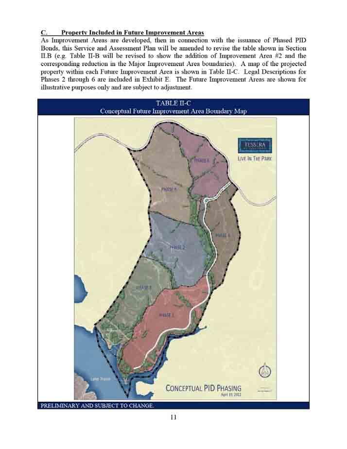
73 D. Future Improvement Area Authorized Improvements As Improvement Areas are developed, then in association with issuing Phased PID Bonds this Service and Assessment Plan will be amended to identify the Phased PID Bond Authorized Improvements that benefit each Improvement Area (e.g., a Table III-C will be added to show the estimated costs for Improvement Area #2 Authorized Improvements, etc.)
74 Section IV ASSESSMENT PLAN A. Introduction The PID Act requires the City Council to apportion the Actual Cost of the Authorized Improvements on the basis of special benefits conferred upon the Property because of the Authorized Improvements. The PID Act provides that the Actual Costs may be assessed: (i) equally per front foot or square foot; (ii) according to the value of the property as determined by the governing body, with or without regard to improvements on the property; or (iii) in any other manner that results in imposing equal shares of the cost on property similarly benefited. The PID Act further provides that the governing body may establish by ordinance or order reasonable classifications and formulas for the apportionment of the cost between the municipality and the area to be assessed and the methods of assessing the special benefits for various classes or improvements. Table IV-A provides the estimated allocation of costs of the Authorized Improvements constituting Major Improvements and Improvement Area #1 Improvements between the Major Improvement Area Assessed Property, Improvement Area #1 Assessed Property, and non-pid property. At this time it is impossible to determine with absolute certainty the amount of special benefit each Parcel within Future Improvement Areas will receive from Phased PID Bond Authorized Improvements. Therefore, at this time Parcels will only be assessed for the special benefits conferred upon the Parcel because of the Major Improvements and Improvement Area #1 Improvements. In connection with issuance of Phased PID Bonds, this Service and Assessment Plan will be updated to reflect the special benefit each Parcel of Assessed Property within a Future Improvement Area receives from the Phased PID Bond Authorized Improvements funded with those Phased PID Bonds issued with respect to that Future Improvement Area. Prior to assessing Parcels located within Future Improvement Areas in connection with issuance of Phased PID bonds, each owner of the Parcels to be assessed must acknowledge that the Phased PID Bond Authorized Improvements confer a special benefit on their Parcel and must consent to the imposition of the Assessments to pay for the Actual Costs. This section of this Service and Assessment Plan currently describes the special benefit received by each Parcel within the PID as a result of the Major Improvements and Improvement Area #1 Improvements, provides the basis and justification for the determination that this special benefit exceeds the amount of the Assessments, and establishes the methodologies by which the City Council allocates and reallocates the special benefit of the Major Improvements and Improvement Area #1 Improvements to Parcels in a manner that results in equal share of the Actual Cost being apportioned to Parcels similarly benefited. The determination by the City Council of the assessment methodologies set forth below is the result of the discretionary exercise by the City Council of its legislative authority and governmental powers and is conclusive and binding on the Developer and all future owners and developers of the Assessed Property
75 As Future Improvement Areas are developed, then in connection with the issuance of Phased PID Bonds this Service and Assessment Plan will be updated based on the City s determination of the assessment methodology for each Future Improvement Area. B. Special Benefit Assessed Property must receive a direct and special benefit from the Authorized Improvements, and this benefit must be equal to or greater than the amount of the Assessments. The Authorized Improvements are provided specifically for the benefit of the Assessed Property. The Authorized Improvements (more particularly described in line-item format on Table III-A and Table III-B to this Service and Assessment Plan) and the costs of issuance and payment of costs incurred in the establishment of the PID shown in Table IV-A are authorized by the Act. Each of the owners of the Assessed Property has acknowledged that the Authorized Improvements confer a special benefit on the Assessed Property and has consented to the imposition of the Assessments to pay for the Actual Costs associated therewith. Each of the owners is acting in its interest in consenting to this apportionment and levying of the Assessments because the special benefit conferred upon the Assessed Property by the Authorized Improvements exceeds the amount of the Assessments. Pursuant to the Landowner s Agreement, each owner of the Assessed Property has ratified, confirmed, accepted, agreed to and approved; (i) the determinations and finding by the City Council as to the special benefits described in this Service and Assessment Plan and the Assessment Ordinance; (ii) the Service and Assessment Plan and the Assessment Ordinance, and (iii) the levying of Assessments on the Assessed Property. Use of the Assessed Property as described in this Service and Assessment Plan and as authorized by the Planned Development District Ordinance requires that Authorized Improvements be acquired, constructed, installed, and/or improved. Funding the Actual Costs through the PID has been determined by the City Council to be the most beneficial means of doing so. As a result, the Assessments result in a special benefit to the Assessed Property, and this special benefit exceeds the amount of the Assessment. This conclusion is based on and supported by the evidence, information, and testimony provided to the City Council. C. Allocation of Actual Costs of Major Improvements The Major Improvements will provide a special benefit to Major Improvement Area Assessed Property and Improvement Area #1 Assessed Property. Accordingly, the Actual Costs of the Major Improvements must be allocated between Major Improvement Area Assessed Property and Improvement Area #1 Assessed Property based on the special benefit each receives. Table IV-A summarizes the allocation of Actual Costs for each Major Improvement. The costs shown in Table IV-A are estimates and may be revised in Annual Service Plan Updates, but may not result in increased Assessments without consent by each of the owners of the Parcels to the imposition of the increased Assessments to pay for the Actual Costs. D. Allocation of Actual Costs of Improvement Area #1 Authorized Improvements The Improvement Area #1 Improvements will provide a special benefit to Improvement Area #1 Assessed Property only. Accordingly, the Actual Costs of the Improvement Area #1 are allocated entirely to Improvement Area #1 Assessed Property based on the special benefit it receives
76 Table IV-A summarizes the allocation of Actual Costs for each Improvement Area #1 Authorized Improvement. The costs shown in Table IV-A are estimates and may be revised in Annual Service Plan Updates, but may not result in increased Assessments without consent by each of the owners of the Parcels to the imposition of the increased Assessments to pay for the Actual Costs. E. Allocation of Actual Costs of Phased PID Bond Authorized Improvements As Future Improvement Areas are developed, then in connection with issuance of Phased PID Bonds this Service and Assessment Plan will be amended to identify the Authorized Improvements that confer a special benefit to property inside the Future Improvement Area resulting from the Phased PID Bond Authorized Improvements (e.g. Table IV-A will be amended to show the estimated allocation of Actual Costs for Improvement Area #2 Authorized Improvements, etc.)
77 77
78 F. Assessment Methodology The Actual Costs may be assessed by the City Council against the Assessed Property so long as the special benefit conferred upon the Assessed Property by the Authorized Improvements equals or exceeds the amount of the Assessments. The Actual Costs may be assessed using any methodology that results in the imposition of equal shares of the Actual Costs on Assessed Property similarly benefited. 1. Assessment Methodology for the Major Improvement Area For purpose of this Service and Assessment Plan, the City Council has determined that the Actual Costs of the portion of the Major Improvements to be financed with the Major Improvement Area Bonds shall be allocated to the Major Improvement Assessed Property by spreading the entire Assessment across all Parcels within the Major Improvement Area based on the ratio of the assessable area of each Parcel of Major Improvement Area Assessed Property to the total assessable area within the Major Improvement Area. Upon subsequent divisions of any Parcel, the Assessment applicable to it will then be apportioned pro rata based on the assessable area of each newly created Parcel. For residential Lots, when final residential building sites are platted, Assessments will be apportioned proportionately among each Lot Type based on the ratio of the estimated average Lot value for the Lot Type at the time residential Lots are platted to the total value of all residential Lots in the platted Parcel, as determined by the Administrator and confirmed by the City Council. The result of this approach is that each final residential Lot within a recorded subdivision plat with similar values will have the same Assessment, with larger, more valuable Lots having a proportionately larger share of the Assessments than smaller, less valuable Lots. As part of the determination as to the ability of different Lot Types to utilize and benefit from the Authorized Improvements, the City Council has taken into consideration that larger, more expensive homes, on average, will create more vehicle trips and greater demands for water and wastewater consumption, and larger, more expensive homes are likely to be built on larger, more valuable lots. The Assessment and Annual Installments for each Parcel or Lot located within the Major Improvement Area is shown on the Major Improvement Area Assessment Roll, attached as Appendix A, and no Assessment shall be changed except as authorized by this Service and Assessment Plan or the PID Act. 2. Assessment Methodology for Improvement Area #1 For purpose of this Service and Assessment Plan, the City Council has determined that the Actual Costs of the portion of the Improvement Area #1 Improvements and the portion of the Major Improvements to be financed with the Improvement Area #1 Bonds shall be allocated to the Improvement Area #1 Assessed Property by spreading the entire Assessment across all Parcels within the Improvement Area #1 based on the ratio of the assessable area of each Parcel to the total assessable area within Improvement Area #
79 Based on the estimates provided by Adams Engineering of the costs of the Improvement Area #1 Improvements and the portion of the Improvement Area #1 Improvements that benefit Phase 1B, as set forth in Table III-B, the City Council has determined that the benefit to Phase 1B property of the Improvement Area #1 Improvements is at least equal to the Assessments levied on the Phase 1B property, and has further determined that, taking into consideration the Improvement Area #1 Improvement costs to be paid by the Developer and that Improvement Area #1 Improvement costs would have been less if they had not been designed to also benefit Phase 1B, Phase 1A and Phase 1B property should pay equal shares of the costs of the Improvement Area #1 Improvements that benefit both Phase 1A and Phase 1B. Upon subsequent divisions of any Parcel, the Assessment applicable to it will then be apportioned pro rata based on the assessable area of each newly created Parcel. For residential Lots, when final residential building sites are platted, Assessments will be apportioned proportionately among each Lot Type based on the ratio of the estimated average Lot value for the Lot Type at the time the residential Lots are platted to the total value of residential Lots in the platted Parcel, as determined by the Administrator and confirmed by the City Council. The result of this approach is that each final residential Lot within a recorded subdivision plat with similar Lot values will have the same Assessment, with more valuable Lots having a proportionately larger share of the Assessments than less valuable Lots. As part of the determination as to the ability of different Lot Types to utilize and benefit from the Authorized Improvements, the City Council has taken into consideration that larger, more expensive homes, on average, will create more vehicle trips and greater demands for water and wastewater consumption and larger, more expensive homes are likely to be built on larger, more valuable lots. The Assessment and Annual Installments for each Parcel or Lot located within Improvement Area #1 is shown on the Improvement Area #1 Assessment Roll, attached as Appendix B, and no Assessment shall be changed except as authorized by this Service and Assessment Plan or the PID Act. 3. Assessment Methodology for Future Improvement Areas When any given Future Improvement Area is developed, and Phased PID Bonds for that Future Improvement Area are to be issued, this Service and Assessment Plan will be amended to determine the assessment methodology that results in the imposition of equal shares of the Actual Costs on Assessed Property similarly benefited within that Improvement Area. G. Assessments The Assessments for the Major Improvement Area Bonds and the Improvement Area #1 Bonds will be levied on each Parcel according to the Major Improvement Area Assessment Roll and the Improvement Area #1 Assessment Roll, attached hereto as Appendix A and Appendix B, respectively. The Annual Installments for the Major Improvement Area Bonds and the Improvement Area #1 Bonds will be collected on the dates and in the amounts shown on the Major Improvement Area Assessment Roll and the Improvement Area #1 Assessment Roll, respectively, subject to any revisions made during an Annual Service Plan Update
80 H. Administrative Expenses The cost of administering the PID and collecting the Annual Installments shall be paid for on a pro rata basis by each Parcel based on the amount of Assessment levied against the Parcel. The Administrative Expenses shall be collected as part of and in the same manner as Annual Installments in the amounts shown on the Major Improvement Area Assessment Roll and the Improvement Area #1 Assessment Roll, which may be revised based on actual costs incurred in Annual Service Plan Updates. I. Prepayment Reserve Pursuant to the PID Act, the interest rate for Assessments may exceed the actual interest rate per annum paid on the related Bonds by no more than one half of one percent (0.50%). The interest rate used to determine the Assessments is one half of one percent (0.50%) per annum higher than the actual rate paid on the Bonds, with 0.20% allocated to fund the associated interest charged between the date of prepayment of an Assessment and the date on which Bonds are prepaid, and 0.30% allocated to fund a delinquency reserve account as described below. J. Delinquency Reserve The City has allocated up to 0.30% of the interest rate component of the Annual Installments to offset any possible delinquent payments. The additional reserve shall be funded up to 10% of the next year s debt service for the related Bonds, but in no event will the annual collection be more than 0.30% higher than the actual interest rate paid on the Bonds. If in a given year the additional reserve is fully funded at 10% of the next year s debt service, the City can allocate up to 0.30% of the interest rate component of the Annual Installments to any other use that benefits the Assessed Property, as determined by the City Council
81 Section V SERVICE PLAN The PID Act requires the service plan to cover a period of at least five years. The service plan is required to define the annual projected costs and indebtedness for the Authorized Improvements undertaken within the PID during the five year period. It is anticipated that it will take approximately 24 months for the Major Improvements to be constructed and approximately 24 months for the Improvement Area #1 Improvements to be constructed. At some point after the Major Improvements and Improvement Area #1 Improvements are constructed, Improvement Area #2 will begin development. After Improvement Area #2 is developed, it is anticipated that Improvement Area #3 will begin development, and so on, with each Future Improvement Area to be subsequently developed corresponding to the Service and Assessment Plan to be updated with that development. The estimated Actual Costs for Major Improvements and Improvement Area #1 Improvements plus costs related to the issuance of the Bonds, and payment of expenses incurred in the establishment, administration and operation of the PID is $27,640,978 as shown in Table IV-A. The service plan shall be reviewed and updated at least annually at the first regularly scheduled City Council meeting in May of each year for the purpose of determining the annual budget for Administrative Expenses, updating the estimated Authorized Improvement costs, and updating the Assessment Roll. Any update to this Service and Assessment Plan is herein referred as an Annual Service Plan Update. Table V-A summarizes the sources and uses of funds required to construct the Major Improvements and Improvement Area #1 Improvements, establish the PID, and issue the Improvement Area #1 PID Bonds and Major Improvement Area Bonds. The sources and uses of funds shown in Table V-A shall be updated each year in the Annual Service Plan Update to reflect any budget revisions and Actual Costs. As Future Improvement Areas are developed in connection with the issuance of Phased PID Bonds, this Service and Assessment Plan will be amended (e.g. Table V-A will be amended to add Improvement Area #2, etc.)
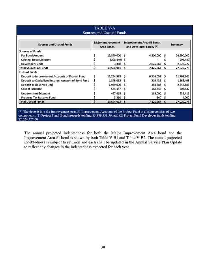
82 82
83 83
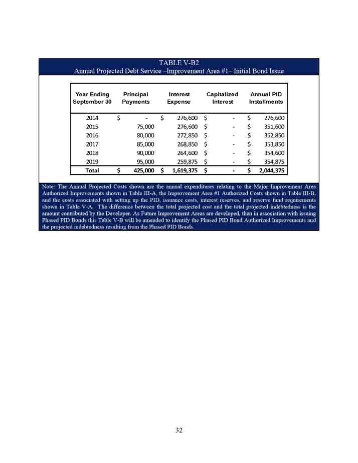
84 84
85 Section VI TERMS OF THE ASSESSMENTS A. Amount of Assessments and Annual Installments for Parcels Located Within Major Improvement Area The Assessment and Annual Installments for each Assessed Property located within the Major Improvement Area is shown on the Major Improvement Area Assessment Roll, attached as Appendix A, and no Assessment shall be changed except as authorized by this Service and Assessment Plan and the PID Act. The Annual Installments shall be collected in an amount sufficient to pay principal and interest on the Major Improvement Area Bonds, to fund the prepayment reserve and delinquency reserve described in Section IV, and to cover Administrative Expenses of the Major Improvement Area. B. Amount of Assessments and Annual Installments for Parcels Located Within Improvement Area #1 The Assessment and Annual Installments for each Assessed Property located within Improvement Area #1 is shown on the Improvement Area #1 Assessment Roll, attached as Appendix B, and no Assessment shall be changed except as authorized by this Service and Assessment Plan and the PID Act. The Annual Installments shall be collected in an amount sufficient to pay principal and interest on the Improvement Area #1 Bonds, to fund the prepayment reserve and delinquency reserve described in Section IV, and to cover Administrative Expenses of Improvement Area #1. C. Amount of Assessments and Annual Installments for Parcels Located Within Future Improvement Areas As Future Improvement Areas are developed, this Service and Assessment Plan will be amended to determine the Assessment and Annual Installments for each Assessed Property located within Future Improvement Areas (e.g. an Appendix will be added as the Assessment Roll for Improvement Area #2, etc.). The Assessments shall not exceed the benefit received by the Assessed Property. D. Reallocation of Assessments for Parcels Located Within the Major Improvement Area and Improvement Area #1 1. Upon Division Prior to Recording of Subdivision Plat Upon the division of any Assessed Property (without the recording of subdivision plat), the Administrator shall reallocate the Assessment for the Assessed Property prior to the division among the newly divided Assessed Properties according to the following formula: A = B x (C D) 33 85
86 Where the terms have the following meanings: A = the Assessment for the new divided Assessed Property B = the Assessment for the Assessed Property prior to division C = the acreage of the new divided Assessed Property D = the sum of the acreage for all of the new divided Assessed Properties The calculation of the acreage of an Assessed Property shall be performed by the Administrator based on information available in the Official Public Records of Travis County, Texas regarding the Assessed Property. The calculation as confirmed by the City Council shall be conclusive. The sum of the Assessments for all newly divided Assessed Properties shall equal the Assessment for the Assessed Property prior to subdivision. The calculation shall be made separately for each newly divided Assessed Property. The reallocation of an Assessment for an Assessed Property that is a homestead under Texas law may not exceed the Assessment prior to the reallocation. Any reallocation pursuant to this section shall be reflected in an update to this Service and Assessment Plan approved by the City Council. A hypothetical example of how assessments are reallocated upon division prior to the recording of a subdivision Plat is attached as Appendix C. 2. Upon Subdivision by a Recorded Subdivision Plat Upon the subdivision of any Assessed Property based on a recorded Subdivision Plat, the Administrator shall reallocate the Assessment for the Assessed Property prior to the subdivision among the new subdivided Lots according to the following formula: A = [B x (C D)]/E Where the terms have the following meanings: A = the Assessment for the new subdivided Lot B = the Assessment for the Parcel prior to subdivision C = the sum of the estimated average Lot value of all new subdivided Lots with same Lot Type D = the sum of the estimated average Lot value for all of the new subdivided Lots excluding Non-Benefitted Property E= the number of Lots with same Lot Type 34 86
87 Prior to the recording of a subdivision plat, the Developer shall provide the City an estimated Lot value as of the date of the recorded subdivision plat for each Lot created by the recorded subdivision plat considering factors such as density, lot size, proximity to amenities, view premiums, location, market conditions, historical sales, discussions with homebuilders, and any other factors that may impact Lot value and any other information available to the Developer. The calculation of the estimated average Lot value for a Lot shall be performed by the Administrator and confirmed by the City Council based on information provided by the Developer, homebuilders, third party consultants, and/or the Official Public Records of Travis County, Texas regarding the Lot. The sum of the Assessments for all newly subdivided Lots shall not exceed the Assessment for the portion of the Assessed Property subdivided prior to subdivision. The calculation shall be made separately for each newly subdivided Assessed Property. The reallocation of an Assessment for an Assessed Property that is a homestead under Texas law may not exceed the Assessment prior to the reallocation. Any reallocation pursuant to this section shall be reflected in an update to this Service and Assessment Plan approved by the City Council. A hypothetical example of how assessments are reallocated upon subdivision by a subdivision plat is attached as Appendix D. 3. Upon Consolidation Upon the consolidation of two or more Assessed Properties, the Assessment for the consolidated Assessed Property shall be the sum of the Assessments for the Assessed Properties prior to consolidation. The reallocation of an Assessment for an Assessed Properties that is a homestead under Texas law may not exceed the Assessment prior to the reallocation. Any reallocation pursuant to this section shall be calculated by the Administrator and reflected in an update to this Service and Assessment Plan approved by the City Council. E. Reallocation of Assessments for Parcels Located Within Future Improvement Areas As Future Improvement Areas are developed, this Service and Assessment Plan will be amended to determine the assessment reallocation methodology that results in the imposition of equal shares of the Actual Costs on Assessed Property similarly benefited within each Future Improvement Area. F. Mandatory Prepayment of Assessments If Assessed Property or portion thereof is transferred to a party that is exempt from the payment of the Assessment under applicable law, or if an owner causes a Parcel or portion thereof to become Non-Benefited Property, the owner of such Parcel or portion thereof shall pay to the Administrator the full amount of the Assessment, plus all Prepayment Costs, for such Parcel or portion thereof prior to any such transfer or act; provided, however that such mandatory prepayment of assessment shall not be required for portions of a Parcel that are dedicated for use as internal roads, parks and other similar, public improvements prior to the recording of the plat 35 87
88 for a Parcel that has been subdivided, in which case the Assessment that was allocated to that certain Parcel in which the public improvement is located will be reallocated to similarly benefitted Parcels, as more fully described in Section VI.D; provided, however, that reallocation of an Assessment for a Parcel that is a homestead under Texas Law may not exceed the Assessment prior to reallocation. G. Reduction of Assessments 1. If after all Authorized Improvements to be funded with a series of Bonds have been completed, including any additional Authorized Improvements described in Section VI.J and Section VI.K, and Actual Costs for such Authorized Improvements are less than the Actual Costs used to calculate the Assessments securing such series of Bonds, resulting in excess Bond proceeds being available to redeem Bonds of such series, then the Assessment securing such series of Bonds for each Assessed Property shall be reduced by the City Council prorata such that the sum of the resulting reduced Assessments for all Assessed Properties equals the actual reduced Actual Costs and such excess Bond proceeds shall applied to redeem Bonds of such series. The Assessments shall not be reduced to an amount less than the related outstanding series of Bonds. 2. If the Authorized Improvements to be funded with a series of Bonds, including any additional Authorized Improvements described in Section VI.J and Section VI.K, are not undertaken by the City, resulting in excess Bond proceeds being available to redeem Bonds of such series, the Assessment securing such series of Bonds for each Assessed Property shall be reduced by the City Council to reflect only the Actual Costs that were expended and such excess Bond proceeds shall be applied to redeem Bonds of such series. The City Council shall reduce such Assessments for each Assessed Property prorata such that the sum of the resulting reduced Assessments equals the Actual Costs with respect to such Authorized Improvements that were undertaken. The Assessments shall not be reduced to an amount less than the related outstanding series of Bonds. H. Payment of Assessments 1. Payment in Full (a) (b) (c) The Assessment for any Parcel may be paid in full at any time in accordance with applicable laws. Payment shall include all Prepayment Costs. If prepayment in full will result in redemption of Bonds, the payment amount shall receive credit from any proceeds from the reserve fund applied to the redemption under the Indenture, net of any other costs applicable to the redemption of Bonds. If an Annual Installment has been billed prior to payment in full of an Assessment, the Annual Installment shall be due and payable and shall be credited against the payment-in-full amount. Upon payment in full of an Assessment and all Prepayment Costs, the City shall deposit the payment in accordance with the related Indenture; whereupon, the 36 88
89 Assessment shall be reduced to zero, and the owner s obligation to pay the Assessment and Annual Installments thereof shall automatically terminate. The City shall provide the owner of the affected Assessed Property a recordable Notice of PID Assessment Termination. (d) At the option of the Parcel owner, the Assessment on any Parcel may be paid in part in an amount equal to the amount of prepaid Assessments plus Prepayment Costs with respect thereto. Upon the payment of such amount for a Parcel, the Assessment for the Parcel shall be reduced, the Assessment Roll shall be updated to reflect such partial payment, and the obligation to pay the Annual Installment for such Parcel shall be reduced to the extent the partial payment is made. 2. Payment in Annual Installments The Act provides that an Assessment for a Parcel may be paid in full at any time. If not paid in full, the Act authorizes the City to collect interest and collection costs on the outstanding Assessment. An Assessment for a Parcel that is not paid in full will be collected in Annual Installments each year in the amounts shown in the Major Improvement Area Assessment Roll and Improvement Area #1 Assessment Roll, which includes interest on the outstanding Assessment and Administrative Expenses. Each Assessment for a Future Improvement Area shall bear interest at a rate of interest on the Bonds approved and issued by the City to fund all or a portion of the Authorized Improvements for such Future Improvement Area plus up to 0.5%. The Annual Installments as listed on the Major Improvement Area Assessment Roll and Improvement Area #1 Assessment Roll have been calculated assuming a weighted average interest rate on the Bonds of 6.75% and 5.88%, respectively. The Annual Installments may not exceed the amounts shown on the Major Improvement Area Assessment Roll and Improvement Area #1 Assessment Roll except as pursuant to any amendment or update to this Service and Assessment Plan. The Annual Installments shall be reduced to equal the actual costs of repaying the related series of Bonds and actual Administrative Expenses (as provided for in the definition of such term), taking into consideration any other available funds for these costs, such as interest income on account balances. The City reserves and shall have the right and option to refund the Bonds in accordance with Section of the PID Act. In the event of such refunding, the Administrator shall recalculate the Annual Installments, and if necessary, may adjust, or decrease, the amount of the Annual Installment so that total Annual Installments of Assessments will be produced in annual amounts that are required to pay the refunding bonds when due and payable as required by and established in the ordinance and/or the indenture authorizing and securing the refunding bonds, and such refunding bonds shall constitute Bonds for purposes of this Service and Assessment Plan
90 I. Collection of Annual Installments No less frequently than annually, the Administrator shall prepare, and submit to the City Council for its approval; an Annual Service Plan Update to allow for the billing and collection of Annual Installments. Each Annual Service Plan Update shall include an updated Major Improvement Area Assessment Roll and Improvement Area #1 Assessment Roll and a calculation of the Annual Installment for each Assessed Property. Administrative Expenses shall be allocated among Assessed Properties in proportion to the amount of the Annual Installments for the Assessed Property. Each Annual Installment shall be reduced by any credits applied under the applicable Indenture, such as capitalized interest, interest earnings on any account balances, and any other funds available to the Trustee for such purpose, and existing deposits for a prepayment reserve. Annual Installments may be collected by the City (or such entity to whom the City directs) in the same manner and at the same time as ad valorem taxes. Annual Installments shall be subject to the same penalties, procedures, and foreclosure sale in case of delinquencies as set forth in the PID Act. The City Council may provide for other means of collecting the Annual Installments to the extent permitted under the PID Act. The Assessments shall have lien priority as specified in the PID Act. Any sale of Assessed Property for nonpayment of the delinquent Annual Installments shall be subject to the lien established for the remaining unpaid Annual Installments against such Assessed Property and such Assessed Property may again be sold at a judicial foreclosure sale if the purchaser thereof fails to make timely payment of the non-delinquent Annual Installments against such Assessed Property as they become due and payable. Each Annual Installment, including the interest on the unpaid amount of an Assessment, shall be assessed on September 1 and shall be due on October 1 of that year. Each Annual Installment together with interest thereon shall be delinquent if not paid prior to February 1 of the following year. J. Surplus Funds Remaining in Major Improvement Area Bond Account If Major Improvement Area Bond proceeds still remain after all of the Major Improvements are constructed and accepted by the City, the proceeds may be utilized to finance other Authorized Improvements that specially benefit all Major Improvement Area Assessed Property. K. Surplus Funds Remaining in Improvement Area #1 Bond Account If Improvement Area #1 Bond proceeds still remain after all of the Improvement Area #1 Improvements (including Improvement Area #1 s share of the Major Improvements) are constructed and accepted by the City, the proceeds may be utilized to finance other Authorized Improvements that specially benefit all Improvement Area #1 Assessed Property
91 Section VII THE ASSESMENT ROLL A. Major Improvement Area Assessment Roll Each Parcel within the Major Improvement Area has been evaluated by the City Council (based on the Planned Development District Ordinance, developable area, proposed Homeowner Association Property and Public Property, the Major Improvements, best and highest use of land, and other development factors deemed relevant by the City Council) to determine the amount of Assessed Property within the Parcel. Major Improvement Area Assessed Property will be assessed for the special benefits conferred upon the property because of the Major Improvements. Table IV-A summarizes the $19,890,000 in special benefit received by Major Improvement Area Assessed Property from the Major Improvements, the costs of the PID formation, and Bond issuance costs. The amount of Major Improvement Area Bonds is $19,890,000, which is equal to the benefit received by Major Improvement Area Assessed Property, and as such the total Assessment for all Assessed Property within the Major Improvement Area is $19,890,000 plus annual Administrative Expenses. The Assessment for each Assessed Property within the Major Improvement Area is calculated based on the allocation methodologies described in Section IV.F of this Service and Assessment Plan. The Major Improvement Area Assessment Roll is attached hereto as Appendix A. B. Improvement Area #1 Assessment Roll Each Parcel within Improvement Area #1 has been evaluated by the City Council (based on the Planned Development District Ordinance, developable area, proposed Homeowner Association Property and Public Property, the Improvement Area #1 Improvements, a proportionate share of the Major Improvements, best and highest use of land, and other development factors deemed relevant by the City Council) to determine the amount of Assessed Property within the Parcel. Improvement Area #1 Assessed Property will be assessed for the special benefits conferred upon the property because of the Improvement Area #1 Improvements that benefit Phase 1A and Phase 1B, and a proportionate share of the Major Improvements. Table IV-A summarizes the $6,514,059 in special benefit received by Improvement Area #1 Assessed Property from the Improvement Area #1 Improvements that benefit Phase 1A and 1B, a proportionate share of the Major Improvements, the costs of the PID formation, and Bond issuance costs. The amount of Improvement Area #1 Bonds is $4,800,000, which is less than the benefit received by Improvement Area #1 Assessed Property, and as such the total assessment for all Assessed Property within Improvement Area #1 is $4,800,000 plus annual Administrative Expenses. The Assessment for each Assessed Property within Improvement Area #1 is calculated based on the allocation methodologies described in Section IV.F of this Service and Assessment Plan. The Improvement Area #1 Assessment Roll is attached hereto as Appendix B
92 C. Future Improvement Area Assessment Roll As Future Improvement Areas are developed, this Service and Assessment Plan will be amended to determine the Assessment for each Parcel located within Future Improvement Areas (e.g. an appendix will be added as the Assessment Roll for Improvement Area #2, etc.). D. Annual Assessment Roll Updates The Administrator shall prepare, and shall submit to the City Council for approval, annual updates to the Major Improvement Area Assessment Roll and Improvement Area #1 Assessment Roll in conjunction with the Annual Service Plan Update to reflect the following matters, together with any other changes helpful to the Administrator or the City and permitted by the Act: (i) the identification of each Parcel (ii) the Assessment for each Assessed Property, including any adjustments authorized by this Service and Assessment Plan or in the PID Act; (iii) the Annual Installment for the Assessed Property for the year (if the Assessment is payable in installments); and (iv) payments of the Assessment, if any, as provided by Section VI.H of this Service and Assessment Plan. Once Bonds are issued in addition to the Major Improvement Area Bonds and the Improvement Area #1 Bonds, the Assessment Roll shall be updated, which update may be done in the next Annual Service Plan Update, to reflect any changes resulting from the issuance of the Bonds. This update shall reflect the actual interest on the Bonds on which the Annual Installments shall be paid, any reduction in the Assessments, and any revisions in the Actual Costs to be funded by the Bonds and Developer funds
93 Section VIII MISCELLANEOUS PROVISIONS A Administrative Review The City may elect to designate a third party to serve as Administrator. The City shall notify Developer in writing at least thirty (30) days in advance before appointing a third party Administrator. To the extent consistent with the PID Act, an owner of an Assessed Property claiming that a calculation error has been made in the Major Improvement Area Assessment Roll and/or Improvement Area #1 Assessment Roll, including the calculation of the Annual Installment, must send a written notice describing the error to the City no later than thirty (30) days after the date any amount which is alleged to be incorrect is due prior to seeking any other remedy. If an owner fails to give such notice, such owner shall be deemed to have accepted the calculation of the Major Improvement Assessment Roll and/or Improvement Area #1 Assessment Roll (including the Annual Installments) and to have waived any objection to the calculation. The Administrator shall promptly review the notice, and if necessary, meet with the Assessed Property owner, consider written and oral evidence regarding the alleged error and decide whether, in fact, such a calculation error occurred. If the Administrator determines that a calculation error has been made and the Major Improvement Area Assessment Roll and/or Improvement Area #1 Assessment Roll should be modified or changed in favor of the Assessed Parcel owner, such change or modification shall be presented to the City Council for approval, to the extent permitted by the PID Act. A cash refund may not be made for any amount previously paid by the Assessed Parcel owner (except for the final year during which the Annual Installment shall be collected), but an adjustment may be made in the amount of the Annual Installment to be paid in the following year. The decision of the Administrator regarding a calculation error relating to the Major Improvement Area Assessment Roll and/or Improvement Area #1 Assessment Roll may be appealed to the City Council for determination. Any amendments made to the Major Improvement Area Assessment Roll and/or Improvement Area #1 Assessment Roll pursuant to calculation errors shall be made pursuant to the PID Act. B Termination of Assessments Each Assessment shall terminate on the date the Assessment is paid in full, including payment of any unpaid Annual Installments and Delinquent Collection Costs, if any. After the termination of an Assessment, and the collection of any delinquent Annual Installments and Delinquent Collection Costs, the City shall provide the owner of the affected Parcel a recordable Notice of the PID Assessment Termination
94 C Amendments Amendments to the Service and Assessment Plan can be made as permitted or required by the PID Act and under Texas law. D Administration and Interpretation of Provisions The City Council shall administer (or cause the administration of) the PID, this Service and Assessment Plan, and all Annual Service Plan Updates consistent with the PID Act, and shall make all interpretations and determinations related to the application of this Service and Assessment Plan unless stated otherwise herein or in the Indenture, such determinations shall be conclusive. E Severability If any provision, section, subsection, sentence, clause or phrase of this Service and Assessment Plan, or the application of same to an Assessed Parcel or any person or set of circumstances is for any reason held to be unconstitutional, void or invalid, the validity of the remaining portions of this Service and Assessment Plan or the application to other persons or sets of circumstances shall not be affected thereby, it being the intent of the City Council in adopting this Service and Assessment Plan that no part thereof, or provision or regulation contained herein shall become inoperative or fail by reason of any unconstitutionality, voidness or invalidity of any other part hereof, and all provisions of this Service and Assessment Plan are declared to be severable for that purpose. If any provision of this Service and Assessment Plan is determined by a court to be unenforceable, the unenforceable provision shall be deleted from this Service and Assessment Plan and the unenforceable provision shall, to the extent possible, be rewritten to be enforceable and to give effect to the intent of the City
95 Appendix A Major Improvement Area Assessment Roll 43 95
96 96
97 97
98 98
99 99
100 100
101 101
102 102
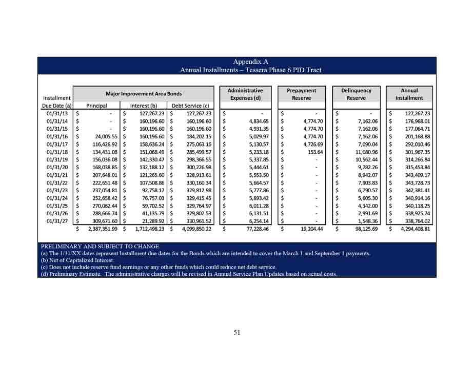
103 103
104 104
105 Appendix B Improvement Area #1 Assessment Roll
106 106
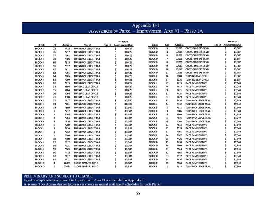
107 107
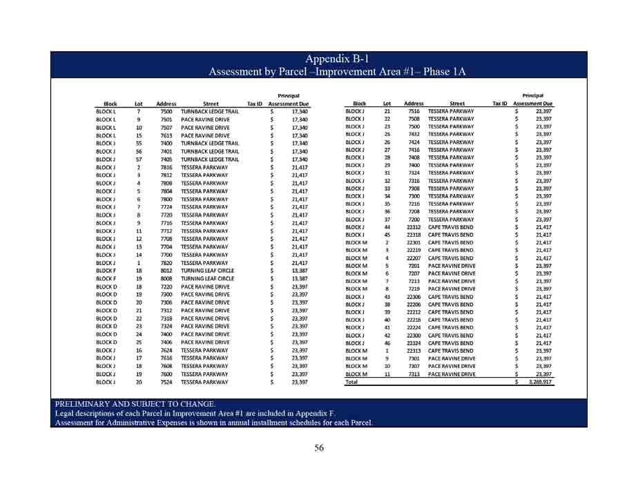
108 108
109 109
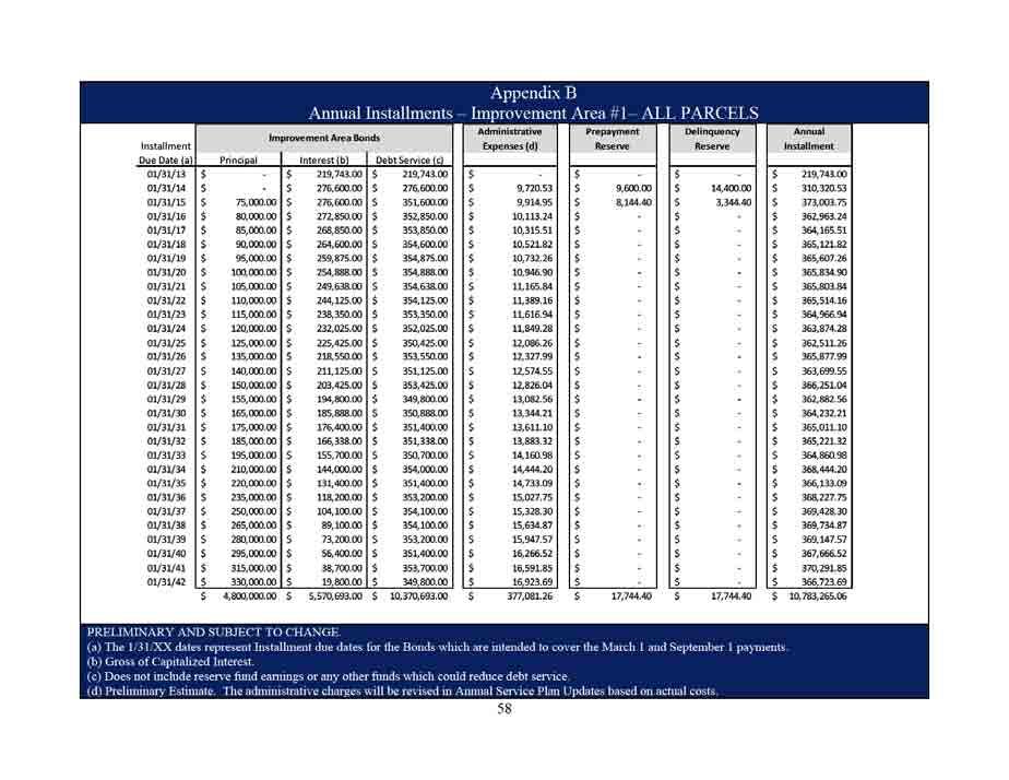
110 110
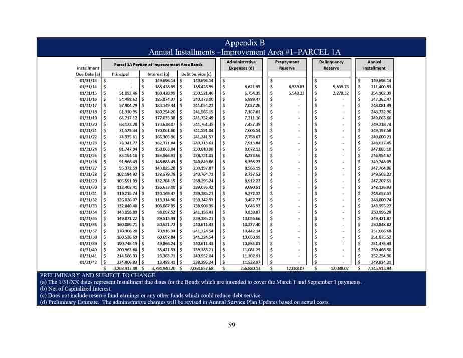
111 111
112 112
113 Appendix C Reallocation of Assessments Assuming Subdivision of Parcel Prior to Recording of Subdivision Plat (HYPOTHETICAL - FOR ILLUSTRATIVE PURPOSES ONLY) Reallocation of Assessments Assuming Subdivision of Parcel Prior to Recording of Subdivision Plat (HYPOTHETICAL FOR ILLUSTRATIVE PURPOSES ONLY) The table below summarizes a hypothetical scenario in which $7,500,000 in assessments levied against Parcel A, which consists of 300 acres, are reallocated when Parcel A is subdivided into 6 smaller Parcels (but prior to recording of a subdivision plat). The scenario assumes 5 parcels totaling 295 acres are classified as Assessable Property, while 1 Parcel consisting of 5 acres is classified as Non Benefited property. Prior to Subdivision Parcel Acreage Total Assessment Parcel A 300 $ 7,500,000 After Subdivision A = B x (C D) B C D Assessment for Assessment for the New Divided the Assessed Assessed Property Prior to Property Division Acreage of the New Divided Assessed Property Sum of Acreage for All New Divided Assessed properties Assessable or Non Parcel Benefitted Property? Parcel A 1 Assessable Property $2,542,373 $7,500, Parcel A 2 Assessable Property $1,906,780 $7,500, Parcel A 3 Assessable Property $1,271,186 $7,500, Parcel A 4 Assessable Property $1,271,186 $7,500, Parcel A 5 Assessable Property $508,475 $7,500, Parcel A 6* Non Benefitted Property $0 $7,500, $7,500, * Parcel A 6 consists of 5 acres of Non Benefitted Property, therefore the Acreage of Parcel A 6 excluding Non Benefited Property is
114 Appendix D Reallocation of Assessments Assuming Subdivision by a Recorded Subdivision Plat (HYPOTHETICAL - FOR ILLUSTRATIVE PURPOSES ONLY) The table below summarizes a hypothetical scenario in which $500,000 in assessments levied against Parcel A, which consists of 20 acres, are reallocated when Parcel A is subdivided by a Recorded Subdivision Plat into 12 residential Lots. The scenario assumes the Lots will be classified into 4 Lot Types, with the assessment per Lot Type ranging from $30,335 for Lot Type 1 to $53,417 for Lot Type IV. Parcel Acres Total Assessment Parcel A 20 $ 500,000 Prior to Subdivision After Subdivision Lot Types I II III IV Estimated Lot Price Range for Lot Type Less than $80,000 $80,001 $100,000 $100,001 $120,000 Greater than $120,001 A = [B x (C D)] E B C D E Parcel Estimated Lot Price Lot Type Assessment For New Subdivided Lot Assessment for the Parcel Prior to Subdivision Sum of Estimated Lot Prices for All Lots in Lot Type Sum of Estimated Lot Price For all Lots Number of Lots with Same Lot Type Lot A 1 $ 75,000 I $ 30,335 $500,000 $145,000 $ 1,195,000 2 Lot A 2 $ 70,000 I $ 30,335 $500,000 $145,000 $ 1,195,000 2 $ 145,000 $ 60,669 Lot A 3 $ 95,000 II $ 37,573 $500,000 $449,000 $ 1,195,000 5 Lot A 4 $ 84,000 II $ 37,573 $500,000 $449,000 $ 1,195,000 5 Lot A 5 $ 88,000 II $ 37,573 $500,000 $449,000 $ 1,195,000 5 Lot A 6 $ 92,000 II $ 37,573 $500,000 $449,000 $ 1,195,000 5 Lot A 7 $ 90,000 II $ 37,573 $500,000 $449,000 $ 1,195,000 5 $ 449,000 $ 187,866 Lot A 8 $ 106,000 III $ 45,607 $500,000 $218,000 $ 1,195,000 2 Lot A 9 $ 112,000 III $ 45,607 $500,000 $218,000 $ 1,195,000 2 $ 218,000 $ 91,213 Lot A 10 $ 125,000 IV $ 53,417 $500,000 $383,000 $ 1,195,000 3 Lot A 11 $ 130,000 IV $ 53,417 $500,000 $383,000 $ 1,195,000 3 Lot A 12 $ 128,000 IV $ 53,417 $500,000 $383,000 $ 1,195,000 3 $ 383,000 $ 160,251 Total $ 1,195,000 $ 500,
115 Appendix E Legal Descriptions for Parcels within Major Improvement Area
116 Appendix F Legal Descriptions for Parcels within Improvement Area #
117 117
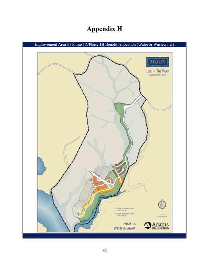
118 118
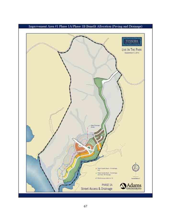
119 119
120 120
121 121
122 70 122
123 Attachment Tessera SAP Differences 123
124 Section III DESCRIPTION OF THE AUTHORIZED IMPROVEMENTS A. Authorized Improvement Overview Section of the PID Act defines the Authorized Improvements that may be undertaken by a municipality or county through the establishment of a public improvement district. Authorized Improvements that may be undertaken pursuant to the PID Act include the following: (i) landscaping; (ii) erection of fountains, distinctive lighting, and signs; (iii) acquiring, constructing, improving, widening, narrowing, closing, or rerouting of sidewalks or of streets, any other roadways, or their rights-of way; (iv) construction or improvement of pedestrian mall; (v) acquisition and installment of pieces of art; (vi) acquisition, construction or improvement of libraries; (vii) acquisition, construction or improvement of off-street parking facilities; (viii) acquisition, construction or improvement of rerouting of mass transportation facilities; (ix) acquisition, construction or improvement of water, wastewater, or drainage facilities or improvements; (x) the establishment or improvement of parks; (xi) projects similar to those listed in Subdivisions (i)-(x) (xii) acquisition, by purchase or otherwise, of real property in connection with an authorized improvement; (xiii) special supplemental services for improvement and promotion of the district, including services relating to advertising, promotion, health and sanitation, water and wastewater, public safety, security, business recruitment, development recreation and cultural enhancement; and (xiv) payment of expenses incurred in the establishment, administration and operation of the district. After analyzing the public improvement projects authorized by the PID Act, the City has determined that the Authorized Improvements described in Section III.B and Section III.C of this Service and Assessment Plan should be undertaken by the City. B. Descriptions and Estimated Costs of Major Improvements The Major Improvements benefit the entire PID. However, Major Improvement Area Assessed Property does not include Improvement Area #1 Assessed Property; therefore the costs of the Major Improvements are allocated proportionally between Major Improvement Area Assessed Property and Improvement Area #1 Assessed Property based on the projected number of residential units within their respective boundaries. Improvement Area #1 is projected to contain 316 residential units and the Major Improvement Area is projected to contain 1,684 residential units within their respective boundaries, resulting in 16% of the Major Improvements allocated to Improvement Area #1 Assessed Property and 84% to Major Improvement Area Assessed 124
125 Property. Major Improvement Area Bonds will fund the Major Improvement Area s proportionate share of the costs of the Major Improvements, and Improvement Area #1 Bonds will fund the Improvement Area #1 s proportionate share of the costs of the Major Improvements. The Major Improvements are described below. The costs of the Major Improvements are shown in Table III-A. The costs shown in Table III-A are estimates and may be revised in Annual Service Plan Updates. Water o Water Treatment Plant #1 Upgrades The Lago Vista Water Treatment Plant No. 1 (WTP) will be upgraded for the first phase of 490 Living Unit Equivalents (LUE s) by adding two pumps next to the existing booster pump building at WTP; minimum capacity of each pump is 500 gpm; a scada system and control valves at City WTP. The upgrades will include limited site work, pumping equipment, piping, and electrical equipment improvements. Under the Restated Development Agreement these WTP upgrades will be constructed to City standards and specifications and will be owned and operated by the City. o Water Line 1 This project consists of constructing approximately 9,000 linear feet of 12 diameter water transmission main from the WTP. The project will be constructed within the existing right of way (ROW) of Seminole Drive, Clubhouse Drive, Bonanza Drive, Canyon Drive, Dawn Drive, Valleyview Drive, Park Drive, Verde Vista Drive and Brewer Lane and will end at the intersection of Brewer Lane and Deepwood Drive. The line will be designed and constructed in accordance with City of Lago Vista standards and specifications and will be owned and operated by the City. The line will have all the necessary appurtenances to be a fully operational transmission main. The line will provide service to Tessera on Lake Travis. o Water Line 2 This project consists of constructing approximately 8,000 linear feet of 14 diameter water transmission mains from a connection point in Water Line 1 at Brewer Lane and Deepwood Drive. The project will be constructed within the existing right of way (ROW) of Deepwood Drive, Ridgeview Road, Packsaddle Trail, Stable Lane, Bar-K-Ranch Road, Surrey Lane and include a 14 diameter water transmission main and a 16 diameter water transmission main crossing Lake Travis through Turnback Cove onto Tessera on Lake Travis. The line will be designed and constructed in accordance with City of Lago Vista standards and specifications and will be owned and operated by the City. The line will have all the necessary appurtenances to be fully operational transmission main. The line will provide service to Tessera on Lake Travis. 125
126 126
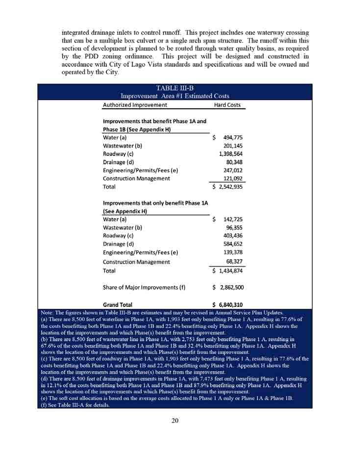
127 127
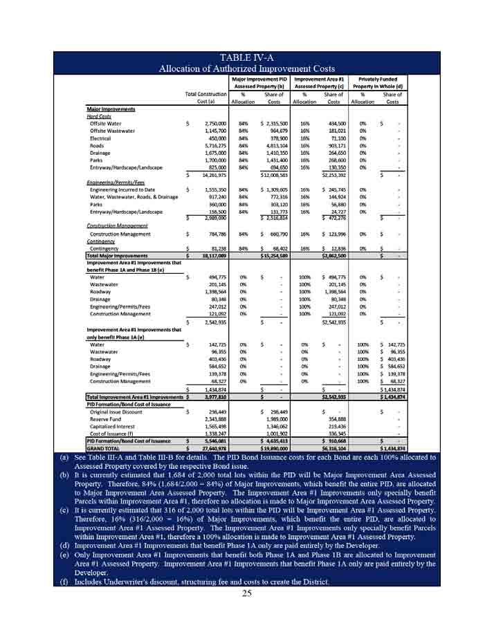
128 128
129 Section VII THE ASSESMENT ROLL A. Major Improvement Area Assessment Roll Each Parcel within the Major Improvement Area has been evaluated by the City Council (based on the Planned Development District Ordinance, developable area, proposed Homeowner Association Property and Public Property, the Major Improvements, best and highest use of land, and other development factors deemed relevant by the City Council) to determine the amount of Assessed Property within the Parcel. Major Improvement Area Assessed Property will be assessed for the special benefits conferred upon the property because of the Major Improvements. Table IV-A summarizes the $19,890,000 in special benefit received by Major Improvement Area Assessed Property from the Major Improvements, the costs of the PID formation, and Bond issuance costs. The amount of Major Improvement Area Bonds is $19,890,000, which is equal to the benefit received by Major Improvement Area Assessed Property, and as such the total Assessment for all Assessed Property within the Major Improvement Area is $19,890,000 plus annual Administrative Expenses. The Assessment for each Assessed Property within the Major Improvement Area is calculated based on the allocation methodologies described in Section IV.F of this Service and Assessment Plan. The Major Improvement Area Assessment Roll is attached hereto as Appendix A. B. Improvement Area #1 Assessment Roll Each Parcel within Improvement Area #1 has been evaluated by the City Council (based on the Planned Development District Ordinance, developable area, proposed Homeowner Association Property and Public Property, the Improvement Area #1 Improvements, a proportionate share of the Major Improvements, best and highest use of land, and other development factors deemed relevant by the City Council) to determine the amount of Assessed Property within the Parcel. Improvement Area #1 Assessed Property will be assessed for the special benefits conferred upon the property because of the Improvement Area #1 Improvements that benefit Phase 1A and Phase 1B, and a proportionate share of the Major Improvements. Table IV-A summarizes the $6,316,104 in special benefit received by Improvement Area #1 Assessed Property from the Improvement Area #1 Improvements that benefit Phase 1A and 1B, a proportionate share of the Major Improvements, the costs of the PID formation, and Bond issuance costs. The amount of Improvement Area #1 Bonds is $4,800,000, which is less than the benefit received by Improvement Area #1 Assessed Property, and as such the total assessment for all Assessed Property within Improvement Area #1 is $4,800,000 plus annual Administrative Expenses. The Assessment for each Assessed Property within Improvement Area #1 is calculated based on the allocation methodologies described in Section IV.F of this Service and Assessment Plan. The Improvement Area #1 Assessment Roll is attached hereto as Appendix B. 129
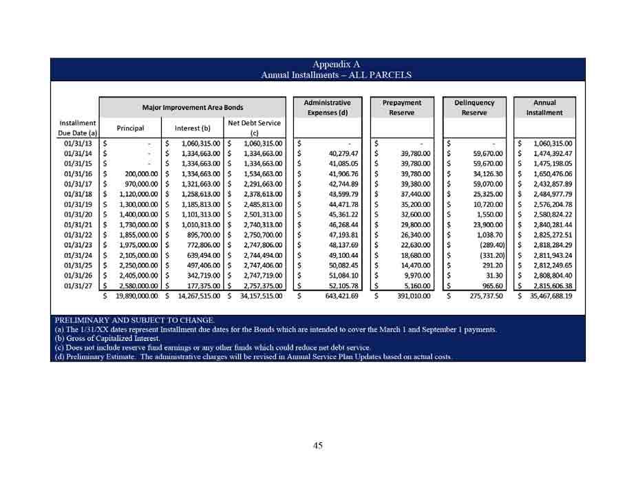
130 130
131 131
132 132
133 133
134 134
135 135
136 136
137 137
138 AGENDA ITEM City of Lago Vista To: Mayor & City Council Council Meeting: September 17, 2015 From: David Harrell, AICP, Development Services Director Subject: A RESOLUTION BY THE CITY COUNCIL OF THE CITY OF LAGO VISTA, TEXAS MOVING EXISTING ALTERNATE MEMBERS TO REGULAR MEMBERS ON THE BOARD OF ADJUSTMENT. Request: Appointments Legal Document: Resolution Legal Review: EXECUTIVE SUMMARY: Jim Speckmann and Bob Graff, alternate members have expressed interest to be appointed as regular members. These appointments will create two openings for alternate members which staff will seek to fill through accepting applications. 138
139 Impact if Approved: Current members will be moved to regular members on the Board and there will be vacancies for the alternate members. Impact if Denied: Current members will stay as an alternate member on the Board and there will be vacancies for the regular member. Is Funding Required? Yes No If Yes, Is it Budgeted? Yes No N/A Indicate Funding Source: N/A Suggested Motion/Recommendation/Action Motion to: Motion to: Motion to: Approve Resolution Deny Resolution Table Resolution Known As: Resolution Agenda Item Approved by City Manager 139
140 CITY OF LAGO VISTA, TEXAS RESOLUTION A RESOLUTION BY THE CITY COUNCIL OF THE CITY OF LAGO VISTA, TEXAS APPOINTING INDIVIDUALS TO FILL REMAINDER OF TERMS OF TWO REGULAR MEMBERS ON THE BOARD OF ADJUSTMENT. WHEREAS, the Board of Adjustment has two vacancies for regular board members due to the expiration of previous regular member and resignation of a regular member earlier this year, and WHEREAS, it is prudent to appoint people with experience on the Board of Adjustment to become a regular member, and WHEREAS, two current alternate members, Jim Speckmann and Bob Graff have expressed interest in being appointed to a regular member on the Board. NOW, THEREFORE, BE IT RESOLVED BY THE CITY COUNCIL OF THE CITY OF LAGO VISTA, TEXAS: THAT, the City Council of the City of Lago Vista, Texas, does hereby appoint Jim Speckmann to fill the remainder of the term for Place 1 and Bob Graff to fill the remainder of the term for Place 3 as a regular member with terms expiring on January 1, AND, IT IS SO RESOLVED. PASSED AND APPROVED this 17th day of September, Attest: Randy Krueger, Mayor Sandra Barton, City Secretary On a motion by Council Member, seconded by Council Member, the above and foregoing instrument was passed and approved. 140
141 CITY OF LAGO VISTA, TEXAS RESOLUTION A RESOLUTION BY THE CITY COUNCIL OF THE CITY OF LAGO VISTA, TEXAS APPOINTING INDIVIDUALS TO FILL REMAINDER OF TERMS OF TWO REGULAR MEMBERS ON THE BOARD OF ADJUSTMENT. WHEREAS, the Board of Adjustment has two vacancies for regular board members due to the expiration of previous regular member and resignation of a regular member earlier this year, and WHEREAS, it is prudent to appoint people with experience on the Board of Adjustment to become a regular member, and WHEREAS, two current alternate members, Jim Speckmann and Bob Graff have expressed interest in being appointed to a regular member on the Board. NOW, THEREFORE, BE IT RESOLVED BY THE CITY COUNCIL OF THE CITY OF LAGO VISTA, TEXAS: THAT, the City Council of the City of Lago Vista, Texas, does hereby appoint Jim Speckmann to fill the remainder of the term for Place 1 and Bob Graff to fill the remainder of the term for Place 3 as a regular member with terms expiring on January 1, AND, IT IS SO RESOLVED. PASSED AND APPROVED this 17th day of September, Attest: Randy Krueger, Mayor Sandra Barton, City Secretary On a motion by Council Member, seconded by Council Member, the above and foregoing instrument was passed and approved. 141
142 AGENDA ITEM City of Lago Vista To: Mayor & City Council Council Meeting: September 17, 2015 From: David Harrell, AICP, Development Services Director Subject: A RESOLUTION BY THE CITY COUNCIL OF THE CITY OF LAGO VISTA, TEXAS MOVING AN EXISTING ALTERNATE MEMBER TO A REGULAR MEMBER ON THE AIRPORT ADVISORY BOARD. Request: Appointments Legal Document: Resolution Legal Review: EXECUTIVE SUMMARY: Michael Hurosky, an alternate member has expressed an interest to be appointed as a regular member. This appointment will create an opening for an alternate member which staff will seek to fill through accepting applications. 142
143 Impact if Approved: Current member will be moved to a regular member on the Board and there will be a vacancy for an alternate member. Impact if Denied: Current member will stay as an alternate member on the Board and there will be a vacancy for a regular member. Is Funding Required? Yes No If Yes, Is it Budgeted? Yes No N/A Indicate Funding Source: N/A Suggested Motion/Recommendation/Action Motion to: Motion to: Motion to: Approve Resolution Deny Resolution Table Resolution Known As: Resolution Agenda Item Approved by City Manager 143
144 CITY OF LAGO VISTA, TEXAS RESOLUTION A RESOLUTION BY THE CITY COUNCIL OF THE CITY OF LAGO VISTA, TEXAS APPOINTING AN INDIVIDUAL TO FILL REMAINDER OF TERM OF REGULAR MEMBER ON THE AIRPORT ADVISORY BOARD. WHEREAS, the Airport Advisory Board has a vacancy for a regular board member due to the expiration of a term earlier this year, and WHEREAS, it is prudent to appoint a person with experience on the Airport Advisory Board to become a regular member, and WHEREAS, a current alternate member, Michael Hurosky has expressed interest in being appointed to a regular member on the Board. NOW, THEREFORE, BE IT RESOLVED BY THE CITY COUNCIL OF THE CITY OF LAGO VISTA, TEXAS: THAT, the City Council of the City of Lago Vista, Texas, does hereby appoint Michael Hurosky to fill the remainder of the regular member s term expiring January 1, AND, IT IS SO RESOLVED. PASSED AND APPROVED this 17th day of September, Attest: Randy Krueger, Mayor Sandra Barton, City Secretary On a motion by Council Member, seconded by Council Member, the above and foregoing instrument was passed and approved. 144
145 CITY OF LAGO VISTA, TEXAS RESOLUTION A RESOLUTION BY THE CITY COUNCIL OF THE CITY OF LAGO VISTA, TEXAS APPOINTING AN INDIVIDUAL TO FILL REMAINDER OF TERM OF REGULAR MEMBER ON THE AIRPORT ADVISORY BOARD. WHEREAS, the Airport Advisory Board has a vacancy for a regular board member due to the expiration of a term earlier this year, and WHEREAS, it is prudent to appoint a person with experience on the Airport Advisory Board to become a regular member, and WHEREAS, a current alternate member, Michael Hurosky has expressed interest in being appointed to a regular member on the Board. NOW, THEREFORE, BE IT RESOLVED BY THE CITY COUNCIL OF THE CITY OF LAGO VISTA, TEXAS: THAT, the City Council of the City of Lago Vista, Texas, does hereby appoint Michael Hurosky to fill the remainder of the regular member s term expiring January 1, AND, IT IS SO RESOLVED. PASSED AND APPROVED this 17th day of September, Attest: Randy Krueger, Mayor Sandra Barton, City Secretary On a motion by Council Member, seconded by Council Member, the above and foregoing instrument was passed and approved. 145
146 146
147 AGENDA ITEM City of Lago Vista To: Mayor & City Council Council Meeting: September 17, 2015 From: David Harrell, AICP, Director Subject: Recommendation of the Planning & Zoning Commission of a Home Occupation at 3601 Hamilton (Highland Lakes Estate, Section 11, Lot 11003) for a kayak rental business (Permit#2244) Request: Public Hearing Legal Document: Other Legal Review: EXECUTIVE SUMMARY: Please see attached staff report. The Planning & Zoning Commission heard the item at their September 10, 2015 meeting date. At that meeting they recommended approval by a vote of 6 to
148 Impact if Approved: The business will be legal and allowed to continue. Impact if Denied: The business will not be legal and the City will shut it down. Is Funding Required? Yes No If Yes, Is it Budgeted? Yes No N/A Indicate Funding Source: Not Applicable Suggested Motion/Recommendation/Action Motion to: Motion to: Motion to: Approve Item Deny Item Table Item Known As: Permit #2244 Agenda Item Approved by City Manager 148
149 Development Services Department STAFF REPORT Application for Home Occupation File Number: Permit #2244 Date: September 2, 2015 Applicant: Representative: Roland & Laura Rodriguez SAME Hearing Dates: Planning & Zoning Commission September 10, 2015 City Council September 17, 2015 Location: 3601 Hamilton Ave. APPLICATION SUMMARY Recommendation of the Planning & Zoning Commission of a Home Occupation at 3601 Hamilton (Highland Lakes Estate, Section 11, Lot 11003) for a kayak rental business (Permit #2225). DEVELOPMENT REVIEW DEPARTMENT COMMENTS With Chapter 14, Article , Section 16 is the zoning requirements of a home occupation. A home occupation is defined as An accessory use of a dwelling unit for gainful employment involving the manufacture, assembly, provision or sale of goods and/or services. The accessory use is conducted entirely within the dwelling unit. The use is clearly incidental and secondary to the use of the dwelling for residence purposes and does not change the character thereof or adversely affect the uses permitted in the residential district of which it is a part. Any home occupation requires an application be filed with the City, review of applicable code requirements, and eventual approval or denial based on the Code. Within Chapter 14, Article , Section is a list of approvable uses for a home occupation in which the City can sign off, however there is a list of prohibited uses within Chapter 14, Article , Section where an application will be denied. In circumstances where uses are not directly listed as an approvable use or a deniable use it must go before the Planning & Zoning Commission for a recommendation and City Council for a consideration. When deciding on an unlisted use, use limitations within Chapter 14, Article , Section apply as well as the purpose and intent within Chapter 14, Article , Section This home occupation consists of a mobile web based business that serves the local lakefront parks, private homes, and condos. The business typically operates between Memorial Day Labor Day and kayaks, paddles, and life vests are stored off-site with the exception of inspections and for security purposes. However during the off-season all products are stored in the attached garage. 149
150 USE LIMITATIONS (A) Such occupation shall be conducted solely by family members residing in the residence plus no more than one nonresident assistant or employee. (B) No more than twenty-five (25) percent of the gross living area of said residence shall be used for such purpose. Use of garage or accessory buildings for these purposes is discouraged. (C) No use shall require external structural alteration or involve construction features or the use of electrical or mechanical equipment that would change the fire rating of the structure. No alteration or change in the premises or building shall be made that will make, result in or cause the main structure to appear in any way to be anything but a residential dwelling unit. (D) There shall be no outside storage of any kind related to the home occupation. (E) There shall be no display of products or material visible in any manner from the outside of the dwelling. (F) No use shall create noise, dust, vibration, smell, smoke, flare, electrical interference, fire hazard, or any other hazard or nuisance to any greater or more frequent extent than that usually experienced in a residential zoned district. (G) No advertising, display or other signs shall be permitted on the premises. (H) No toxic, explosive, flammable, combustible, corrosive, etiologic, radioactive, or other restricted material is used or stored on the site. (I) No process is used which is in violation of any city, state or federal rule, regulation, or law. (J) No advertisement shall be placed in any media containing the address of the property if the business is one which involves traffic or customers to purchase goods or service. (K) Parking for home occupations: (1) The business shall not generate vehicular traffic requiring parking spaces beyond those normally allotted to residential use. (2) Curbside or edge-of-street parking related to a home occupation is prohibited. 150
151 PURPOSE AND INTENT In regards to unlisted uses not listed in the code, the purpose and intent of the regulations must be considered. As shown in Chapter 14, Article , Section 16.10, the purpose and intent of the home occupation regulations are stated below: Intent and Purpose. Traditionally certain occupational uses termed home occupation have been allowed in dwelling units. Such uses have been allowed largely on the basis that such uses are incidental to the use of the premises as a residence, that the nature of the home occupation use is such that it is compatible with residential neighborhoods, or that home occupation uses are of a highly professional nature involving the use of mental rather than physical capabilities and are therefore compatible with residential uses. STAFF ANALYSIS (A) The above criteria defy precise definition or interpretation: Definition of home occupations by the above criteria has in some cases totally prohibited home occupations while in other instances allowed uses which markedly detract from the residential character of a neighborhood and thereby infringed upon the rights of surrounding residents. (B) It is recognized that certain limited home occupation uses can be useful to both the general community as well as the resident-proprietor. Also recognized is the difficulty of writing an ordinance dealing with home occupations in a middle-of-the-road fashion, which is neither discriminatory nor arbitrary. It is hoped that the citizens will recognize these difficulties and will not abuse the privileges granted within this section. (C) With the above in mind, it is the intent and purpose to provide for certain types of restricted occupational uses within residential zoning. Only such uses will be allowed which: (1) Are incidental to the use of the premises as a residence; (2) Are compatible with residential uses; and (3) Do not detract from the residential character of the neighborhood. (D) Home Occupations that are dependent on traffic of customers to purchase goods or services directly at the dwelling shall not be permitted within residentially zoned districts; provided, however, home occupations which normally generate minimal traffic such as, for example, tailors, seamstresses, accountants, consultants, locksmiths, etc. may be approved for residentially zoned districts. Staff believes the criteria of use limitation are met in Chapter 14, Article , Section it also believes the kayak and associated products is in compliance with Chapter 14, Article , Section In particular it is stated no customers visit the single family home, no vehicles from customers are at the premises, and all sales 151
152 transactions occur online. There would be no issues relating to the detraction of the residential character of the neighborhood and any traffic generated by the business is of a minimal impact to the area. Therefore staff would recommend approval of the home occupation. ATTACHMENTS Additional information is provided through attached exhibits. 1. Applicant Request 2. Site Photo 3. Maps 152
153 Attachment 1 Applicant Request 153
154 154
155 155
156 156
157 157
158 Attachment 2 Site Photo 158
159 159
160 Attachment 3 Maps 160
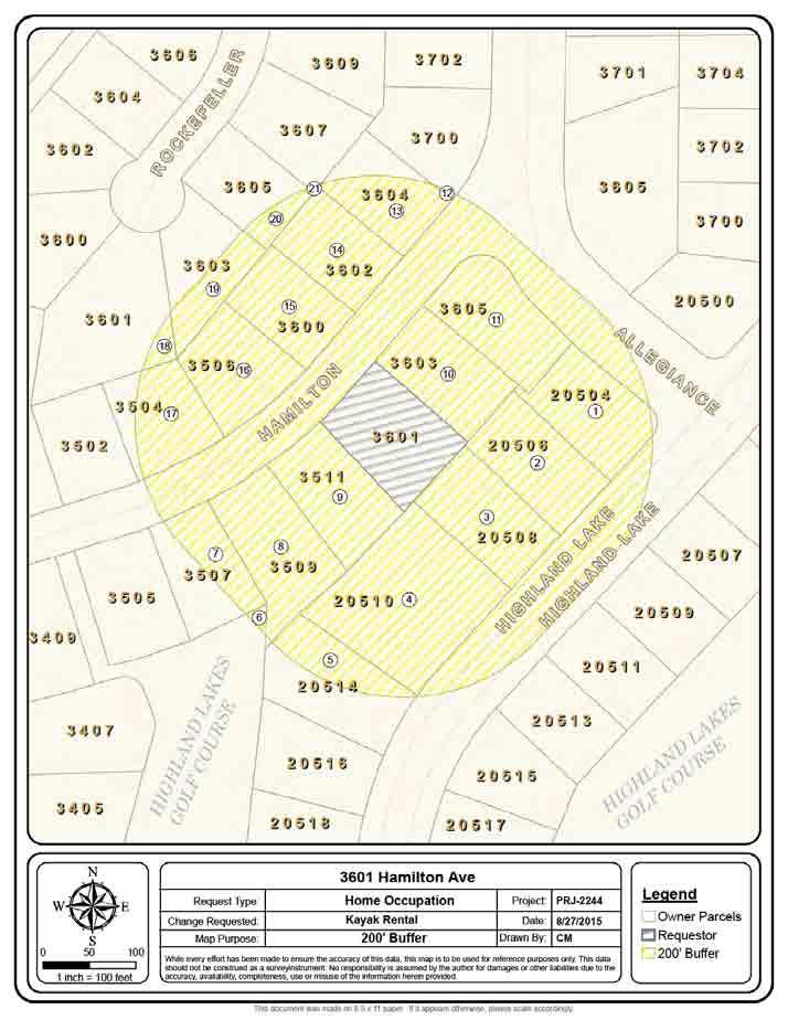
161 161
162 R O C K E F E L L E R HIGHLAND LAKES GOLF COURSE H A M I L T O N H I G H L A N D L A K E A L L E G I A N C E H I G H L A N D L A K E HIGHLAND LAKES GOLF COURSE inch = 100 feet Request Type: Change Requested: Map Purpose: 3601 Hamilton Ave Home Occupation Kayak Rental Aerial & Topo Project: Date: Drawn By: PRJ /27/2015 While every effort has been made to ensure the accuracy of this data, this map is to be used for reference purposes only. This data should not be construed as a surveyinstrument. No responsibility is assumed by the author for damages or other liabilities due to the accuracy, availability, completeness, use or misuse of the information herein provided. CM Legend 20' Contours Owner Parcels Requestor 162 This document was made on 8.5 x 11 paper. If it appears otherwise, please scale accordingly.
163 R O C K E F E L L E R H A M I L T O N A L L E G I A N C E HIGHLAND LAKES GOLF COURSE H I G H L A N D L A K E H I G H L A N D L A K E HIGHLAND LAKES GOLF COURSE inch = 100 feet Request Type: Change Requested: Map Purpose: 3601 Hamilton Ave Home Occupation Kayak Rental Future Land Use Project: Date: Drawn By: PRJ /27/2015 While every effort has been made to ensure the accuracy of this data, this map is to be used for reference purposes only. This data should not be construed as a surveyinstrument. No responsibility is assumed by the author for damages or other liabilities due to the accuracy, availability, completeness, use or misuse of the information herein provided. CM Legend Owner Parcels Requestor Future Land Use Low Density Residential High Density Residential Parks 163 This document was made on 8.5 x 11 paper. If it appears otherwise, please scale accordingly.
164 R O C K E F E L L E R H A M I L T O N A L L E G I A N C E HIGHLAND LAKES GOLF COURSE H I G H L A N D L A K E H I G H L A N D L A K E HIGHLAND LAKES GOLF COURSE inch = 100 feet Request Type: Change Requested: Map Purpose: 3601 Hamilton Ave Home Occupation Kayak Rental Zoning Project: Date: Drawn By: PRJ /27/2015 While every effort has been made to ensure the accuracy of this data, this map is to be used for reference purposes only. This data should not be construed as a surveyinstrument. No responsibility is assumed by the author for damages or other liabilities due to the accuracy, availability, completeness, use or misuse of the information herein provided. CM Legend Owner Parcels Requestor Zoning Class C-1C P-1A G-1 R-1B R-1C R This document was made on 8.5 x 11 paper. If it appears otherwise, please scale accordingly.
165 AGENDA ITEM City of Lago Vista To: Mayor & City Council Council Meeting: September 17, 2015 From: David Harrell, AICP, Director Subject: Recommendation of the Planning & Zoning Commission of a Home Occupation at Sierra Tr. (Bar K Ranches Plat 8, Lot 8133) for a massage therapy business. (Permit #2225). Request: Public Hearing Legal Document: Other Legal Review: EXECUTIVE SUMMARY: Please see attached staff report. The Planning & Zoning Commission heard the item at their September 10, 2015 meeting date. At that meeting they recommended approval by a vote of 6 to
166 Impact if Approved: The business will be legal and allowed to continue. Impact if Denied: The business will not be legal and the City will shut it down. Is Funding Required? Yes No If Yes, Is it Budgeted? Yes No N/A Indicate Funding Source: Not Applicable Suggested Motion/Recommendation/Action Motion to: Motion to: Motion to: Approve Item Deny Item Table Item Known As: Permit #2225 Agenda Item Approved by City Manager 166
167 Development Services Department STAFF REPORT Application for Home Occupation File Number: Permit #2225 Date: September 2, 2015 Applicant: Representative: Rachelle Peralta SAME Hearing Dates: Planning & Zoning Commission September 10, 2015 City Council September 17, 2015 Location: Sierra Tr. APPLICATION SUMMARY Recommendation of the Planning & Zoning Commission of a Home Occupation at Sierra Tr. (Bar K Ranches Plat 8, Lot 8133) for a massage therapy business (Case No. Permit #2225). DEVELOPMENT REVIEW DEPARTMENT COMMENTS With Chapter 14, Article , Section 16 is the zoning requirements of a home occupation. A home occupation is defined as An accessory use of a dwelling unit for gainful employment involving the manufacture, assembly, provision or sale of goods and/or services. The accessory use is conducted entirely within the dwelling unit. The use is clearly incidental and secondary to the use of the dwelling for residence purposes and does not change the character thereof or adversely affect the uses permitted in the residential district of which it is a part. Any home occupation requires an application be filed with the City, review of applicable code requirements, and eventual approval or denial based on the Code. Within Chapter 14, Article , Section is a list of approvable uses for a home occupation in which the City can sign off, however there is a list of prohibited uses within Chapter 14, Article , Section where an application will be denied. In circumstances where uses are not directly listed as an approvable use or a deniable use it must go before the Planning & Zoning Commission for a recommendation and City Council for a consideration. When deciding on an unlisted use, use limitations within Chapter 14, Article , Section apply as well as the purpose and intent within Chapter 14, Article , Section This home occupation consists of using a 10 x 10 room within an existing single family home of a licensed massage therapist. Within the room will consist a massage table and chair. Clients are seen individually by appointment only with one massage client seen at a time. 167
168 USE LIMITATIONS (A) Such occupation shall be conducted solely by family members residing in the residence plus no more than one nonresident assistant or employee. (B) No more than twenty-five (25) percent of the gross living area of said residence shall be used for such purpose. Use of garage or accessory buildings for these purposes is discouraged. (C) No use shall require external structural alteration or involve construction features or the use of electrical or mechanical equipment that would change the fire rating of the structure. No alteration or change in the premises or building shall be made that will make, result in or cause the main structure to appear in any way to be anything but a residential dwelling unit. (D) There shall be no outside storage of any kind related to the home occupation. (E) There shall be no display of products or material visible in any manner from the outside of the dwelling. (F) No use shall create noise, dust, vibration, smell, smoke, flare, electrical interference, fire hazard, or any other hazard or nuisance to any greater or more frequent extent than that usually experienced in a residential zoned district. (G) No advertising, display or other signs shall be permitted on the premises. (H) No toxic, explosive, flammable, combustible, corrosive, etiologic, radioactive, or other restricted material is used or stored on the site. (I) No process is used which is in violation of any city, state or federal rule, regulation, or law. (J) No advertisement shall be placed in any media containing the address of the property if the business is one which involves traffic or customers to purchase goods or service. (K) Parking for home occupations: (1) The business shall not generate vehicular traffic requiring parking spaces beyond those normally allotted to residential use. (2) Curbside or edge-of-street parking related to a home occupation is prohibited. 168
169 PURPOSE AND INTENT In regards to unlisted uses not listed in the code, the purpose and intent of the regulations must be considered. As shown in Chapter 14, Article , Section 16.10, the purpose and intent of the home occupation regulations are stated below: Intent and Purpose. Traditionally certain occupational uses termed home occupation have been allowed in dwelling units. Such uses have been allowed largely on the basis that such uses are incidental to the use of the premises as a residence, that the nature of the home occupation use is such that it is compatible with residential neighborhoods, or that home occupation uses are of a highly professional nature involving the use of mental rather than physical capabilities and are therefore compatible with residential uses. STAFF ANALYSIS (A) The above criteria defy precise definition or interpretation: Definition of home occupations by the above criteria has in some cases totally prohibited home occupations while in other instances allowed uses which markedly detract from the residential character of a neighborhood and thereby infringed upon the rights of surrounding residents. (B) It is recognized that certain limited home occupation uses can be useful to both the general community as well as the resident-proprietor. Also recognized is the difficulty of writing an ordinance dealing with home occupations in a middle-of-the-road fashion, which is neither discriminatory nor arbitrary. It is hoped that the citizens will recognize these difficulties and will not abuse the privileges granted within this section. (C) With the above in mind, it is the intent and purpose to provide for certain types of restricted occupational uses within residential zoning. Only such uses will be allowed which: (1) Are incidental to the use of the premises as a residence; (2) Are compatible with residential uses; and (3) Do not detract from the residential character of the neighborhood. (D) Home Occupations that are dependent on traffic of customers to purchase goods or services directly at the dwelling shall not be permitted within residentially zoned districts; provided, however, home occupations which normally generate minimal traffic such as, for example, tailors, seamstresses, accountants, consultants, locksmiths, etc. may be approved for residentially zoned districts. Staff believes the criteria of use limitation are met in Chapter 14, Article , Section it also believes the massage therapy is in compliance with Chapter 14, Article , Section In particular, minimal customers visits to the single 169
170 family home, similar to a tailor or seamstress, would occur in this case. There would be no issues relating to the detraction of the residential character of the neighborhood and any traffic generated by the business is of a minimal impact to the area. Therefore staff would recommend approval of the home occupation. ATTACHMENTS Additional information is provided through attached exhibits. 1. Applicant Request 2. Site Plan 3. Maps 170
171 Attachment 1 Applicant Request 171
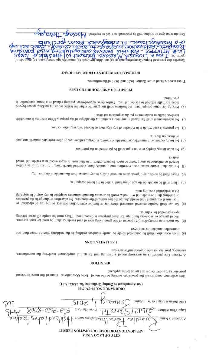
172 172
173 173
174 Attachment 2 Site Plan 174
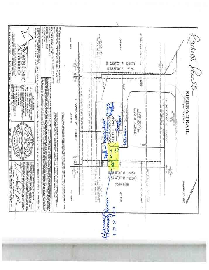
175 175
176 Attachment 3 Maps 176
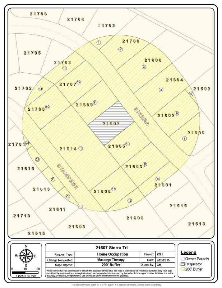
177 177
178 S I E R R A S T A M P E D E inch = 80 feet Request Type: Change Requested: Map Purpose: Sierra Trl Home Occupation Massage Therapy Aerial & Topo Project: Date: Drawn By: 8/26/2015 While every effort has been made to ensure the accuracy of this data, this map is to be used for reference purposes only. This data should not be construed as a surveyinstrument. No responsibility is assumed by the author for damages or other liabilities due to the accuracy, availability, completeness, use or misuse of the information herein provided CM Legend 20' Contours Owner Parcels Requestor 178 This document was made on 8.5 x 11 paper. If it appears otherwise, please scale accordingly.
179 S I E R R A S T A M P E D E inch = 80 feet Request Type: Change Requested: Map Purpose: Sierra Trl Home Occupation Massage Therapy Zoning Project: Date: Drawn By: 8/26/2015 While every effort has been made to ensure the accuracy of this data, this map is to be used for reference purposes only. This data should not be construed as a surveyinstrument. No responsibility is assumed by the author for damages or other liabilities due to the accuracy, availability, completeness, use or misuse of the information herein provided CM Legend Owner Parcels Requestor Zoning Class PDD R-1A TR This document was made on 8.5 x 11 paper. If it appears otherwise, please scale accordingly.
180 S I E R R A S T A M P E D E inch = 80 feet Request Type: Change Requested: Map Purpose: Sierra Trl Home Occupation Massage Therapy Future Land Use Project: Date: Drawn By: 8/26/2015 While every effort has been made to ensure the accuracy of this data, this map is to be used for reference purposes only. This data should not be construed as a surveyinstrument. No responsibility is assumed by the author for damages or other liabilities due to the accuracy, availability, completeness, use or misuse of the information herein provided CM Legend Owner Parcels Requestor Future Land Use Low Density Residentia Public/Semi Public 180 This document was made on 8.5 x 11 paper. If it appears otherwise, please scale accordingly.
181 AGENDA ITEM City of Lago Vista To: Mayor & City Council Council Meeting: September 17, 2015 From: David Harrell, AICP, Director Subject: Discussion and action on formalizing a process of addressing appointed board vacancies for Staff. Request: Business Item Legal Document: Other Legal Review: EXECUTIVE SUMMARY: See Attached Staff Report 181
182 Impact if Approved: Process described in the staff report will be followed and be the standard operating procedure. Staff can begin process of starting to fill vacancies. Impact if Denied: Process described in the staff report will NOT be followed and be the standard operating procedure. Staff cannot begin process of starting to fill vacancies. Is Funding Required? Yes No If Yes, Is it Budgeted? Yes No N/A Indicate Funding Source: N/A Suggested Motion/Recommendation/Action Motion to: Motion to: Motion to: Approve Item Deny Item Table Item Known As: N/A Agenda Item Approved by City Manager 182

183 Development Services Department STAFF REPORT DEVELOPMENT REVIEW DEPARTMENT COMMENTS There are vacancies on several appointed boards and no formal process adopted to address this issue. Staff would suggest the following formalized process: 1. Department Head makes listing of vacancies on the applicable appointed boards or committees 2. Write up a list of vacancies to advertise on web, Facebook, Twitter, North Shore Beacon, send to Development Services via Chris. 3. Advertise giving calendar days for potential candidates to file applications. 4. Gather all applications to present to the Council. 5. Staff provides potential recommendations to Council. 6. Council makes their choice. In instances where no one files an application for a vacancy, wait days and start process over again until applications arrive. Department heads will be in charge of monitoring their individual members to let them know of an upcoming expiration of term and will notify. Also, they will be in charge of filling vacancies. They will work and keep the City Manager informed on the process. Name of Appointed Board Planning & Zoning Commission (Impact Fee Advisory Committee) Board of Adjustment Building Committee Airport Advisory Board Keep Lago Vista Beautiful Parks and Recreation Advisory Board Library Advisory Board Golf Course Advisory Committee Responsibility Development Services Development Services Development Services Development Services Public Works Public Works Library Golf 183
184 AGENDA ITEM City of Lago Vista To: Mayor & City Council Council Meeting: September 17, 2015 From: Melissa Byrne Vossmer, City Manager Subject: FY15/16 Budget Worksession 1. Review of Updated Consolidated Statement as Requested by Council 2. Discussion of Departmental Budgets 3. Other Request: Other Legal Document: Other Legal Review: EXECUTIVE SUMMARY: At the September 10th Special Council Meeting the City Council had an extensive discussion concerning the FY15/16 Budget; changes directed by Council to date; changes recommended by Staff; the Proposed 5-Year CIP, Year 1; water and wastewater rates; and the development of a tax rate that provided for the required debt service (I & S), the level of buy down contributions to debt service from the Impact Fee Fund and the resulting operations and maintenance (O & M) portion of the tax rate. As a result of previous discussion and direction and receipt of the Truth in Taxation calculations from Travis County, an updated Consolidated Statement predicated on a tax rate of $ 0.64 / $100 and an updated revenue statement for the General, Golf and Utility funds was discussed as well. As Council will recall, the delay in receiving this information from Travis County Appraisal District has pushed the budget adoption timeline, providing for publications and notices, to the end of September. Based on Council direction from the September 10th budget discussion, attached is an updated Consolidated Statement reflecting a tax rate of $0.65 / $100. All other previously directed changes / recommendations remain the same and are included. Also attached is a spreadsheet that itemizes those changes / recommendations by Fund. And finally, attached is a spreadsheet that reflects anticipated General Fund revenues. A tax rate cannot be approved by Council until September 29th at the Special Council Meeting. All information is for discussion purposes only. At this time, this is the last scheduled worksession on the FY15/16 Budget. Council, as a result of the 2nd Public Hearing on a Tax Increase, has scheduled the date / time / location of the meeting to consider adoption of a tax rate - the rate is yet to be 184
185 determined - and the FY15/16 Budget. Council can schedule additional budget worksessions as desired. As we continue to move through this process towards adoption, Staff is ready to meet with you or provide any information that would be helpful. Impact if Approved: Not subject to approval. Impact if Denied: Not subject to denial. Is Funding Required? Yes No If Yes, Is it Budgeted? Yes No N/A Indicate Funding Source: Suggested Motion/Recommendation/Action Motion to: Approve Item Motion to: Motion to: Known As: FY15/16 Budget Worksession 185
186 Agenda Item Approved by City Manager 186
187 187
188 188
189 189
190 190
191 191
192 192
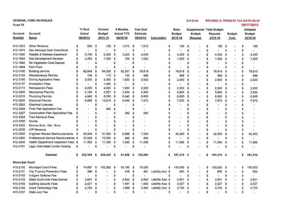
193 193
194 194
195 195
196 196
197 Changes Made to the July 31st Draft Budget Revised - 9/17/15 Council Meeting Fund Department Department Change Description Added Expenditures Increased In-House Transfers Increased Revenues Administration Advalorem Tax Revenue - General Fund $ - $ - $ 226, Administration City Manager Pay Increase - 1/ $ 8,004 $ - $ Administration Pay Plan Adjusment - City Mgr, Finance $ 2, Finance Professional Service - Contract/Maturnity Leave $ 7,200 $ - $ Parks & Recreation 2014/2015 Van Purchased $ 5,604 $ - $ Aviation Airport Master Plan $ 8,000 $ - $ LVGC Revnue Membership Increase - 8% $ - $ - $ 12, LVGV Revenue Utility Fund Transfer $ - $ 30,000 $ LVGC 50% $ 23,181 $ - $ LVGC Increased Fertilizer $ 7,368 $ - $ HLGC Revenue Membership Increase - 8% $ - $ - $ 8, HLGC Revenue Utility Fund Transfer $ 30,000 $ HLGC 50% $ 23,181 $ - $ HLGC Increased Fertilizer $ 5,633 $ - $ Utility Revenue Water Rate - Change to Structure $ - $ - $ 232, Utility Revenue Drought Emergency Fee $ - $ - $ (15,908) Utility Revenue Sewer Rate - Change to Structure $ - $ - $ 57, Utility Administration Nelisa Hedin - Annual Review/Rate Analysis $ 5,000 $ - $ Utility Administration Pay Plan Adjustment - WTP #2 $ (2,239) $ - $ WTP #2 Plant Operator - Vacancy Filled Below Budget $ (6,657) $ - $ Utility Transfer Utility - LVGC Transfer $ 30,000 $ - $ Utility Transfer Utility - HLGC Transfer $ 30,000 $ - $ Debt Service Buy Down/Debt - Impact Fees - Cover $3.7+ Mil Tax Note Interest Payment $ - $ 103,354 $ Debt Service $3.7+ Million Tax Note - Interest Payment $ 103,354 $ - $ - Totals $ 250,162 $ 163,354 $ 521,944 Added Expenditures Increased In-House Transfers Increased Revenues 197
198 198
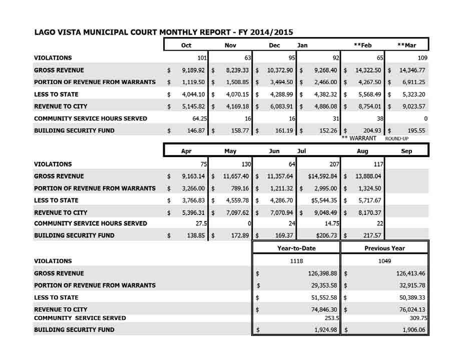
199 199
200 City Of Lago Vista City Council Water & Wastewater Report August 2015 Combined Water Production Raw Water Total Production Total Efficiency Highest Daily Production Average Daily Production Lowest Daily Production Water Plant 1 Raw Water Total Production Total Efficiency Highest Daily Production Average Daily Production Lowest Daily Production Water Plant 2 Raw Water Total Production Total Efficiency Highest Daily Production Average Daily Production Lowest Daily Production Water Plant 3 Raw Water Total Production Total Efficiency Highest Daily Production Average Daily Production Lowest Daily Production Waste Water Treatment Plant Treated Total Highest Daily Treated Average Daily Treated Lowest Daily Treated Effluent Disposal Total Permit Disposal Lago Vista Golf Course Permit Cedar Breaks Permit Bar-K Golf Course Permit Month Summary MG MG 93% MGD MGD MGD Month Summary MG MG 93% MGD MGD MGD Month Summary MG MG 91% MGD MGD MGD Month Summary Future Month Summary MG MGD MGD MGD Month Summary MG MG MG MG Lake Water To Pond 17 Lago Vista Golf Course Usage MG MG 1 of
201 City Of Lago Vista City Council Water & Wastewater Report August 2015 Combined Water Production Raw Water Total Production Total Efficiency Highest Daily Production Average Daily Production Lowest Daily Production Water Plant 1 Raw Water Total Production Total Efficiency Highest Daily Production Average Daily Production Lowest Daily Production Water Plant 2 Raw Water Total Production Total Efficiency Highest Daily Production Average Daily Production Lowest Daily Production Water Plant 3 Raw Water Total Production Total Efficiency Highest Daily Production Average Daily Production Lowest Daily Production Waste Water Treatment Plant Treated Total Highest Daily Treated Average Daily Treated Lowest Daily Treated Effluent Disposal Total Permit Disposal Lago Vista Golf Course Permit Cedar Breaks Permit Bar-K Golf Course Permit 12 Month Summary MG MG 93% MGD MGD MGD 12 Month Summary MG MG 95% MGD MGD MGD 12 Month Summary MG MG 87% MGD MGD MGD 12 Month Summary Future 12 Month Summary MG MGD MGD MGD 12 Month Summary MG MG MG MG Lake Water To Pond 17 Lago Vista Golf Course Usage MG MG 2 of
202 August 2015 Combined Water Production Month Details Raw vs Finished WP1 WP2 Combined WP1 WP2 Combined Date Raw Raw Raw Finished Finished Finished 08/01/ /02/ /03/ /04/ /05/ /06/ /07/ /08/ /09/ /10/ /11/ /12/ /13/ /14/ /15/ /16/ /17/ /18/ /19/ /20/ /21/ /22/ /23/ /24/ /25/ /26/ /27/ /28/ /29/ /30/ /31/ Total (MG) High (MG) Avg (MG) Low (MG) of
203 August 2015 Water Plant 1 Month Details Raw vs Finished Date WP1 Raw WP1 Clarifier A WP1 Clarifier B WP1 Finished WP1 Process Loss Efficiency 08/01/ % 08/02/ % 08/03/ % 08/04/ % 08/05/ % 08/06/ % 08/07/ % 08/08/ % 08/09/ % 08/10/ % 08/11/ % 08/12/ % 08/13/ % 08/14/ % 08/15/ % 08/16/ % 08/17/ % 08/18/ % 08/19/ % 08/20/ % 08/21/ % 08/22/ % 08/23/ % 08/24/ % 08/25/ % 08/26/ % 08/27/ % 08/28/ % 08/29/ % 08/30/ % 08/31/ % Total (MG) % High (MG) Avg (MG) Low (MG) of
204 August 2015 Water Plant 2 Month Details Raw vs Finished Date WP2 Raw To Lohmans To Golfball From Golfball WP2 Finished WP2 Process Loss Efficiency 08/01/ % 08/02/ % 08/03/ % 08/04/ % 08/05/ % 08/06/ % 08/07/ % 08/08/ % 08/09/ % 08/10/ % 08/11/ % 08/12/ % 08/13/ % 08/14/ % 08/15/ % 08/16/ % 08/17/ % 08/18/ % 08/19/ % 08/20/ % 08/21/ % 08/22/ % 08/23/ % 08/24/ % 08/25/ % 08/26/ % 08/27/ % 08/28/ % 08/29/ % 08/30/ % 08/31/ % Total (MG) % High (MG) Avg (MG) Low (MG) of
205 August 2015 Water Plant 3 Month Details Raw vs Finished Date 08/01/15 08/02/15 08/03/15 WP3 Raw Recirc Unit 1 Backwash 08/04/15 08/05/15 15Fu 08/06/15 08/07/15 08/08/15 08/09/15 08/10/15 /12/15 13/ F0 08 5F8 08/ 08/1 08/19/15 F4 08/20/15 08/21/15 08/22/15 08/23/15 08/24/15 08/25/15 08/26/15 08/27/15 08/28/15 08/29/15 08/30/15 08/31/15 WP3 Finished WP3 Process Loss Future F4Fu F1F1Fu /F/Fu ure F9/15F9/15F Efficiency Total (MG) High (MG) Avg (MG) Low (MG) 6 of
206 August 2015 Waste Water Treatment Plant Effluent Disposal Month Details Treated vs Permit WWTP Lake Water Lago Golf Lago Golf Cedar Breaks Bar K Golf Permit Date Treated To Pond 17 Usage Permit Permit Permit Total 08/01/ /02/ /03/ /04/ /05/ /06/ /07/ /08/ /09/ /10/ /11/ /12/ /13/ /14/ /15/ /16/ /17/ /18/ /19/ /20/ /21/ /22/ /23/ /24/ /25/ /26/ /27/ /28/ /29/ /30/ /31/ Total (MG) High (MG) Avg (MG) Low (MG) of
207 August 2015 Combined Water Production 12 Month Details Raw Total vs Finished Total WP1 WP2 Combined WP1 WP2 Combined Date Raw Raw Raw Finished Finished Finished Sep, Oct, Nov, Dec, Jan, Feb, Mar, Apr, May, Jun, Jul, Aug, Total (MG) High (MG) Avg (MG) Low (MG) of
208 August 2015 Water Plant 1 12 Month Details Raw Total vs Finished Total Date WP1 Raw WP1 Clarifier A WP1 Clarifier B WP1 Finished WP1 Process Loss Efficiency Sep, % Oct, % Nov, % Dec, % Jan, % Feb, % Mar, % Apr, % May, % Jun, % Jul, % Aug, % Total (MG) % High (MG) Avg (MG) Low (MG) of
209 August 2015 Water Plant 2 12 Month Details Raw Total vs Finished Total Date WP2 Raw To Lohmans To Golfball From Golfball WP2 Finished WP2 Process Loss Efficiency Sep, % Oct, % Nov, % Dec, % Jan, % Feb, % Mar, % Apr, % May, % Jun, % Jul, % Aug, % Total (MG) % High (MG) Avg (MG) Low (MG) of
210 August 2015 Water Plant 3 12 Month Details Raw Total vs Finished Total Date Sep, 2014 Oct, 2014 Nov, 2014 Dec, 2014 Jan, 2015 Feb, 2015 Mar, 2015 Ap A, To G)Fo G) HighFh Avg (F( Low (MG)F(MG) WP3 Raw Recirc Unit 1 Backwash WP3 Finished WP3 Process Lo AFu Future ure ncy urenc 11 of
211 August 2015 Waste Water Treatment Plant Effluent Disposal 12 Month Details Treated Total vs Permit Total WWTP Lake Water Lago Golf Lago Golf Cedar Breaks Bar K Golf Permit Date Treated To Pond 17 Usage Permit Permit Permit Total Sep, Oct, Nov, Dec, Jan, Feb, Mar, Apr, May, Jun, Jul, Aug, Total (MG) High (MG) Avg (MG) Low (MG) Lago Golf Permit vs Cedar Breaks Permit 15 MG Sep Oct Nov Dec Jan Feb Mar Apr May Jun Jul Aug Lago Golf Cedar Breaks 12 of
212 August 2015 Combined Water Production 5 Year Details 5 Year Average Daily Production Flow Month Year - 4 Year - 3 Year - 2 Last Year This Year <N/A> <N/A> <N/A> <N/A> High (MGD) Avg (MGD) Low (MGD) of
213 August 2015 Waste Water Treatment Plant 5 Year Details 5 Year Average Daily Effluent Flow Month Year - 4 Year - 3 Year - 2 Last Year This Year <N/A> <N/A> <N/A> <N/A> High (MGD) Avg (MGD) Low (MGD) of
214 214
215 Monthly Hydrant Flushing Report City of Lago vista (name of Water System) Month Year July (PWSID) unit conversion factor Formula: GPM = cd 2 p coefficient value 0.95 Date Hydrant Location and/or Number Reason Operated Total Minutes Operated Nozzle size (typically 2.5 or 4.5) Pitot Pressure GPM Gallons Flowed Estimated Flow if Pitot not used 130,000 Total Gallons for Month 130,
216 Fire Department - Water Usage Report Form KRS (3) 807 KAR 5:095 Section 9 Any city, county, urban-county, charter county, fire protection district, or volunteer fire protection district ( User ) may withdraw water from the utility s water distribution system for the purpose of fighting fires or training firefighters at no charge on the condition that it maintains estimates of the amount of water used for fire protection and training during the calendar month and reports the amount of this water usage to the utility no later than the 15th day of the following calendar month. Any city, county, urban-county, charter county, fire protection district, or volunteer fire protection district that withdraws water from the utility s water distribution system for fire protection or training purposes and fails to submit the required report on water usage in a timely manner shall be assessed the cost of this water. A non-reporting user s usage shall be presumed to be 0.3 percent of the utility s total water sales for the calendar month. Date Hydrant Location and/or Number (name of Fire Department) (name of Water System) Reason Operated Total Minutes Operated Nozzle size (typically 2.5 or 4.5) Pitot Pressure Month Year unit conversion factor coefficient value GPM Gallons Flowed 90,000 Estimated Flow if Pitot not used Total Gallons for Month 90,
217 Monthly Excavation Break Report diameter in inches City of Lago vista (name of Water System) Hole = Area = sq. in. 0 (PWSID) length (in) width (in) Month July Crack = Year 2015 Area = 0 sq. in. Area Calculator Insert the approximate dimensions of the hole or crack to determine the area of the break. Insert the area in the spreadsheet below. Date Excavation Break Location Excavator Minutes Hole or Crack? Area of hole or crack Normal PSI GPM Gallons Lost During Break Total Gallons Lost Due to Excavation Breaks 0 217
218 Monthly Leak Repair Report diameter in inches City of Lago vista Hole= (Water System) Area= sq. in. 0 (PWSID) length (in) width (in) Month July Crack= Year 2015 Area= 0 sq. in. Area Calculator Insert the approximate dimensions of the hole or crack to determine the area of the break. Insert the area in the spreadsheet below. Date of Repair Location of Leak or Line Break Days Line Leaked? Hole or Crack? Area of hole or crack Normal PSI GPM Calculated Loss for Month Estimated Loss for Month 1,000,000 Total Gallons Lost Due to Line Breaks 1,000,
219 219
220 220
221 Utility Monthly Report 2014/15 Oct Nov Dec Jan Feb Mar Apr May Jun Jul Aug Sep Totals Number of Water Taps Linear Feet of Water Extensions (including tap , ,650 Number of Sewer Taps Linear Feet of Sewer Extensions (including tap Meter Change Outs Register Change Outs Turn Ons/Offs Disconnects for Nonpayment Meter Reads Only Re-Reads Consumption Reports Day Temproary Connects Check for Leaks Reinstates Number of Water Leaks (including blue poly) Number of Blue Poly Leaks Sewer Line Breaks Sewer Stoppages Linear Feet of Sewer Rodding , ,000 Linear Feet of Camara Work CIP Water Extensions (linear feet) ,200 CIP Sewer Extenstions (linear feet) 2, , ,100 CIP Meter Replacements CIP Fire Hydrant Replacements Jonestown Pump & Haul Loads Water Taps (This line added Aug 2015) Sewer Taps (This line added Aug 2015)
222 222
223 STREET DEPARTMENT ACTIVITY REPORT OCT NOV DEC JAN FEB MAR APR MAY JUN JUL AUG SEP TOTALS STREET PATCHING Tons of Asphalt Used Number of Patches , ,397 Square Feet of Patches 856 1,594 1,781 4,040 5,595 3,052 2,498 2,560 8,302 8,870 2,396 41,544 Tons of Base Material Used Repaint Intersections Replace Reflective Buttons CRACK SEAL PROGRAM Linear Feet of Crack Sealing LANDSCAPING ACTIVITIES Worker Hours ,819 ROADSIDE MOWING Miles Mowed TRAFFIC CONTROL New Signs Installed Signs Replaced DRAINAGE MAINTENANCE Projects Completed Linear Feet of Ditches Cleared ,567 Culverts Cleared MISCELLANEOUS ACTIVITIES Worker Hours on City Clean Up Worker Hours on Burn Day Worker Hours on Park Maint Worker Hours on X-Mas Lights Worker Hours on Tree Trimming ,010 Deer Pick Ups Bldg Maintenance Requests Pool Operation & Maintenance (hrs) Airport Maintenance (hrs) Mowing Bar K Golf Course (hrs) Assist Utility Department (hrs) Assist CIP Projects (hrs) Assist Plant Operations (hrs) Assist Library (hrs) Assist Effluent Department (hrs) Assist Golf Courses (hrs) Assist LVPD (hrs) KLVB Projects (hrs) Special Events (hrs) ,418 RECYCLE CENTER Loads of Brush Collected Wood Chipping (hrs) Loads of Mulch Picked Up Trash/Metal Collection (hrs) Special Comments: Street Department did 3,857 linear feet of striping for Dawn Drive parking spaces. 223
224 224
225 Permits By Type Lago Vista From: 08/01/2015 To: 08/31/2015 Description Residential Permits Permit Number Contractor Address Type Issued Date Square Footage Contstructio n Cost 2131 Highland Homes 7216 Tessera Parkway Residential Single Family 8/4/ $ Highland Homes 7208 Tessera Parkway Residential Single Family 8/4/ $ MHI 7901 Arbor Knoll Court Residential Single Family 8/13/ $ $ Homes Permitted in Tessera 225
226 Permits By Type Lago Vista Description Permit Number Contractor From: 08/01/2015 To: 08/31/2015 Address Issued Date Miscellaneous Permits 2229 Best of Texas 7716 Turnback Ledge Trail Sprinkler System 8/10/ Homeowner Rock Park Ln Residential Accessory 8/10/ Viking Ship Kayak 3601 Hamilton Avenue Home Occupation Permit 8/10/ Elgin Sprinkler Cross Timbers Bend Sprinkler System 8/20/ Homeowner Leaning Oak Drive Residential Accessory 8/25/ Shamrock Total Lawn 2913 Patriot Drive Sprinkler System 8/31/ Homeowner Dawn DRive Residential Accessory 8/31/ Lago Vista Fence Lee Lane Fence 8/4/ Gofers Paseo De Vaca Residential Accessory 8/10/ Loan Simple Sunset Strip Home Occupation Permit 8/11/ Elgin Sprinkler Cross Timbers Bend Sprinkler System 8/20/ Cape Lago 5801 Thunderbird Fence 8/24/ Harold Nelson Dawn Drive Fence 8/25/ KC Water Filtration 4201 Vista Corta Home Occupation Permit 8/31/ Premier Home Service 7609 Sleepy Hollow Remodeling 8/4/ Ryan Zimmerman Highland Lakes Deck 8/3/ Homeowner Continental Drive Fence 8/5/ Lago Vista Fence 4011 Rockwood Dr Fence 8/13/2015 Type 2248 Chaparral Surveying CVS Driveway Site Development Plan 8/14/2015 Improvement 2253 Lago Vista Fence 4802 Thunderbird Drive Fence 8/24/ Lago Vista Car Wash 7903 Bronco Lane Fence 8/28/ Maria's FM 1431 (Marias) Fence 8/31/2015 Sign Permits Real Estate FM 1431 #202 Temporary Banner 8/24/2015 Contstruction Cost $ $ No Value $ $ $ $ $ $ No Value $ $ $ No Value $ $ $ $ No Value Reported $ $ $ $ No Value Reported Real Estate FM 1431 #202 Sign Variance 8/24/2015 No Value Reported $
227 Permits By Type Lago Vista From: 08/01/2015 To: 08/31/2015 Description Permit Contractor Address Type Issued Date Electrical Trade 2129 IES 7208 Tessera Parkway Residential Electrical 8/10/2015 Permits 2131 IES 7216 Tessera Parkway Residential Electrical 8/10/ ATX Electrical 6302 Lakeshore Dr Minor Electrical Repairs 8/5/ Canyon Electric Surrey Lane Residential Electrical 8/5/ TMC Electric 3935 Outpost Trace Residential Electrical 8/11/2015 Mechanical Trade Permits Plumbing Trade Permits 2130 Austin Air Conditioning 9402 Rolling Hills Trail Commercial Mechancial 8/17/ Casa Mechanical 7712 Turnback Ledge Trail Residential Mechanical 8/17/ Casa Mechanical 7906 Turnback Ledge Trail Residential Mechanical 8/17/ Ishtel Heating & Air 7708 Lohman Ford 102 Commercial Mechancial 8/25/ Ishtel Heating & Air 7708 Lohman Ford Bldg A Commercial Mechancial 8/25/ Big Tex AC 7618 Turnback Ledge Trail Residential Mechanical 8/18/ Big Tex AC 7909 Arbor Knoll Court Residential Mechanical 8/18/ Sierra Air Services, Inc Paine Avenue Minor Mechancial Repairs 8/31/ Casa Mechanical 7912 Arbor Knoll Court Residential Plumbing 8/5/ Casa Mechanical Cross Timbers Bend Residential Plumbing 8/5/ Casa Mechanical Cross Timbers Bend Residential Plumbing 8/26/ A, K & J Plumbing Oakdale Drive Residential Plumbing 8/7/ Walters Plumbing Boggy Ford Road Minor Plumbing Repairs 8/5/ Lantz Lakeside Plumbing Northland Residential Plumbing 8/12/ Lantz Lakeside Plumbing Twain Cove Residential Plumbing 8/12/ Mustang Plumbing 7813 Turnback Ledge Trail Residential Plumbing 8/24/ Duder's Plumbing 49 Oak Place Minor Plumbing Repairs 8/17/ A, K & J Plumbing Lakefront Drive Residential Plumbing 8/4/ Walters Plumbing 2500 Mayflower Cove Minor Plumbing Repairs 8/12/ Walters Plumbing 6103 Camille Court Minor Plumbing Repairs 8/12/ Mustang Plumbing 7208 Tessera Parkway Residential Plumbing 8/14/ Mustang Plumbing 7216 Tessera Parkway Residential Plumbing 8/14/ Casa Mechanical 3209 Eisenhower Residential Plumbing 8/14/ Lantz Lakeside Plumbing 3002 Drake Cove Residential Plumbing 8/27/
228 Permits By Type Lago Vista From: 08/01/2015 To: 08/31/ GC Plumbing 3935 Outpost Trace Residential Plumbing 8/24/ Casa Mechanical 7901 Arbor Knoll Court Residential Plumbing 8/18/ Church Services Adobe Trail Minor Plumbing Repairs 8/24/
229 CERTIFICATE OF OCCUPANCY REPORT Permit Number Cert. Of Occupancy Owner Name Location Permit Type /17/2015 MHI Cross Timbers Bend Lago Vista TX Residential Single Family /24/2015 Travista Homes LLC 3929 Outpost Trace Lago Vista TX Residential Single Family /28/2015 Andy Abrams Bryan Cove Lago Vista TX Residential Single Family /07/2015 Vista Verde Custom Homes 4011 Rockwood Drive Lago Vista TX Residential Single Family Tessera 229
230 Zoning and Subdivision Report Lago Vista From: 08/01/2015 To: 08/31/2015 Description Platting Zoning Permit Number SUB-1095 SUB-1096 SUB-1097 ZON-1044 ZON-1045 Address 20701,20703 Osage & 20700, O Neill 8100 & 8102 Bronco Lane 2300 & 2301 Washington Cove Falcon Street Montechino Type Lot Consolidation Lot Consolidation Lot Consolidation Variance (Setback) Re-Zoning Request Creation Date 08/03/ /12/ /31/ /11/ /31/
231 New Residential Construction issued in September 2007 Total: 7 Construction Date Permit # Address Subdivision Section Lot(s) Zoning Contractor Living Garage Costs 7/2/2007 BP Patton Ave. Highland Lake Estates R1-B Serrano Homes, LLC $105,000 7/2/2007 BP La Mesa Lago Vista Estates 2 20 R1-D Owner $125,000 7/5/2007 BP Stagecoach Cove Bar K Ranches A R1-A Doug Casey Homes $850,000 7/6/2007 BP National Dr. LV Country Club Estates R1-G Reytex Homes, Inc $242,500 7/6/2007 BP Lincoln Cove Highland Lake Estates R1-A Reytex Homes, Inc $244,624 7/27/2007 BP Outpost Trace Country Club Estates R1-G Summer View Homes, LLC $170,000 7/31/2007 BP Outpost Trace Country Club Estates R1-G North Shore Construction $300,000 Flood Zone SF Residential Permits issued in July 2007 Total: 2 Construction Date Permit # Address Subdivision Section Lot(s) Zoning Contractor Living Garage Costs 7/5/2007 BFSF Bar K Ranch Rd. Bar K Ranches R1-B Canyon Builders $245,000 7/16/2007 BF2F Sana Monica Ave. #A& #B Highland Lake Estates A R2 South Shore Custom Homes $270,000 Commercial Building Permits issued in July 2007 Total: 3 Construction Date Permit # Address Subdivision Section Lot(s) Zoning Contractor Costs 7/9/2007 BPC Flighline Rd. Bar K Airport 54 C4 Hangar Rental, Inc. $96,000 7/31/2007 BPC American Dr. #1 & #2 Vista Villas 1 PDD Doug Casey Homes $435,000 7/31/2007 BPC American Dr. #1 & #2 Vista Villas 1 PDD Doug Casey Homes $435,
232 Miscellaneous Building Permits issued in July 2007 Total: 11 Sub-Contractor Permits issued in September 2006 (Electrical, Mechanical, and Plumbing) Total: 35 Number of Onsite Inspections completed in July 2007 Last inspection number entered as of 07/31/2007: INSP Total: 95 Certificates of Occupancy issued in July 2007 Total: 6 Date Permit No. Address Subdivision Section Lot(s) Zoning 7/2/2007 BP American Cove Highland Lake Estates R1-B 7/6/2007 BP National Dr. Country Club Estates R1-G 7/6/2007 BP Lincoln Cove Highland Lake Estates R1-A 7/12/2007 BP Rockefeller Cove Highland Lake Estates R1-C 7/13/2007 BP Northland Dr. Lago Vista Estates R1-D 7/25/2007 BPC Highland Lake Dr. Vista Villas 1 PDD Contractor Dream Homes Saul Martinez Reytex Homes, Inc. Bogey Investments, Inc Reytex Homes, Inc. Doug Casey Homes 232
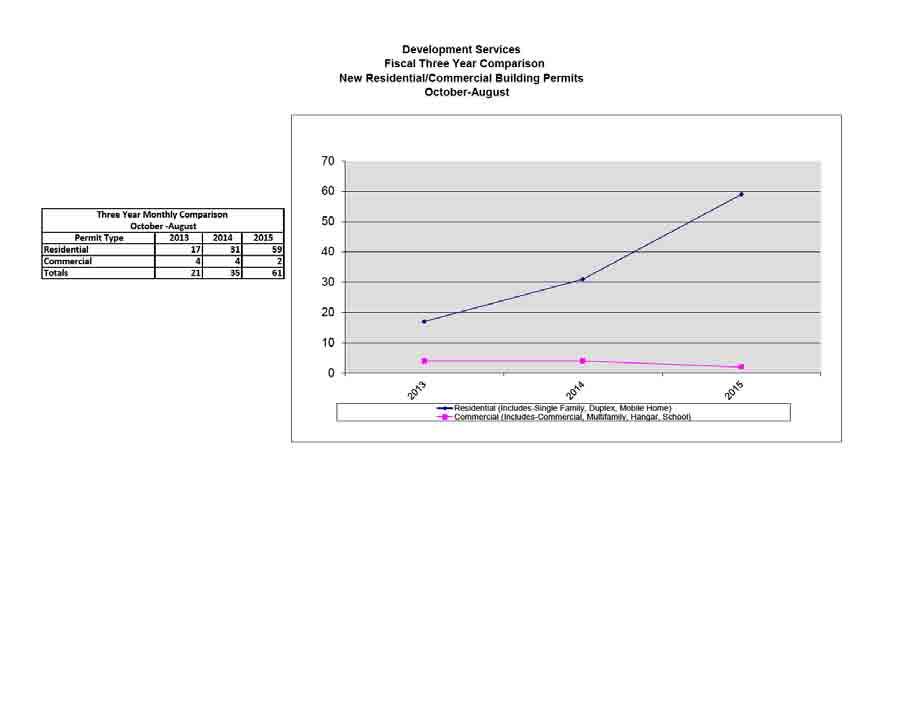
233 233
234 Oct-12 Nov-12 Dec-12 Jan-13 Feb-13 Mar-13 Apr-13 May-13 Jun-13 Jul-13 Aug-13 Sep-13 Totals R1 single family R-2 duplex or 2 family 0 R-4 multifamily 0 Hangar 2 2 Commercial 1(School) 1 (New Office) 2 Totals Fiscal 14 Oct-13 Nov-13 Dec-13 Jan-14 Feb-14 Mar-14 Apr-14 May-14 Jun-14 Jul-14 Aug-14 Sep-14 Totals R1 single family R-2 duplex or 2 family 0 R-4 multifamily 0 Hangar Commercial 1 (Tenanat Finish Out) 1(Pavilion) 1 Totals Fiscal 15 Oct-14 Nov-14 Dec-14 Jan-15 Feb-15 Mar-15 Apr-15 May-15 Jun-15 Jul-15 Aug-15 Sep-15 Totals R1 single family R-2 duplex or 2 family 0 R-4 multifamily 0 HANGAR 1 1 Commercial 1(Tenant Finish Out) 1 Totals
235 Building Other Ordinance Violations Code Enforcement Report August 2015 Permit Number Address Type CE Dawn Dr. Commercial dumpster violation CE Bronco Lane Commercial dumpster violation CE American Dr. Commercial dumpster violation CE Bison Trl. Encroach on city or private property CE Bison Trl. Encroach on city or private property CE Comstock Cv. Failure to maintain structure CE Coyote Trail Mobile Home violation CE Comstock Cove Open/Unsecured vacant building CE High Mountain Dr. Other Building Violations CE Cowpoke Trail Other Building Violations CE Arena Path Other Building Violations CE Boone Dr. Pool Fencing violation CE Bison Trl. Site development w/o permit CE Rimrock Dr. All other miscellaneous violations CE Outpost Trace All other miscellaneous violations CE MacArthur #B All other miscellaneous violations CE Santa Carlo Ave. All other miscellaneous violations CE Boggy Ford Rd. All other miscellaneous violations CE Patton Ave. All other miscellaneous violations CE Patton Ave. All other miscellaneous violations CE Penn Cove All other miscellaneous violations CE Ticonderoga Ave All other miscellaneous violations CE Parliament Cove All other miscellaneous violations CE Parliament Cove All other miscellaneous violations CE Parliament Cove All other miscellaneous violations CE Mac Arthur Ave. All other miscellaneous violations CE Mac Arthur Ave. #B All other miscellaneous violations CE Lake Park Cove All other miscellaneous violations CE Country Club Dr. All other miscellaneous violations CE Highland Lake Dr. All other miscellaneous violations CE High Dr. All other miscellaneous violations CE Rock Terrace Dr. All other miscellaneous violations CE Cabot Cove All other miscellaneous violations CE Constitution Dr. All other miscellaneous violations CE Highland Lake Dr. All other miscellaneous violations CE Thunderbird St. #B All other miscellaneous violations CE Silverhill Dr. All other miscellaneous violations CE High Dr. All other miscellaneous violations CE Mount Laurel All other miscellaneous violations CE Mount Laurel Dr. All other miscellaneous violations CE Mount View Dr. All other miscellaneous violations CE Mount View Dr. All other miscellaneous violations CE High Dr. All other miscellaneous violations CE Outpost Trace All other miscellaneous violations CE Outpost Trace All other miscellaneous violations CE Outpost Trace All other miscellaneous violations CE Bridle Path Rd. All other miscellaneous violations CE Horseshoe Loop All other miscellaneous violations CE Dodge Trl All other miscellaneous violations CE Bonanza St. #A All other miscellaneous violations CE Bonanza St. All other miscellaneous violations CE Outpost Trace All other miscellaneous violations CE Cabot Cove All other miscellaneous violations CE Paine Ave. All other miscellaneous violations CE Highland Lake Dr. All other miscellaneous violations CE Bonanza St. All other miscellaneous violations CE Shady Lane All other miscellaneous violations CE Shady Lane All other miscellaneous violations 235
236 CE Oak Dale Dr. All other miscellaneous violations CE Lakefront Dr. All other miscellaneous violations CE Coyote Trail #C All other miscellaneous violations CE Coyote Trail All other miscellaneous violations CE Burnside Cir All other miscellaneous violations CE MacArthur Ave #B All other miscellaneous violations CE Choctaw Cove Disconnected water service CE Travis Dr. #A Disconnected water service CE Coyote Trail #6A Disconnected water service CE Continental Dr. Disconnected water service CE Santa Ana Cove Disconnected water service CE Coyote Trl. Fire Code Violation CE Fire Code Violation CE Ridgeview Circle Illegal Dumping violation CE Rimrock Ct. Junk/abandoned vehicle CE Rockefeller Cove Junk/abandoned vehicle CE Rockefeller Cove Junk/abandoned vehicle CE Park Strip Junk/abandoned vehicle CE Choctaw Cove Junk/abandoned vehicle CE Choctaw Cove Junk/abandoned vehicle CE Choctaw Cove Junk/abandoned vehicle CE Choctaw Cove Junk/abandoned vehicle CE Choctaw Cove Junk/abandoned vehicle CE Choctaw Cove Junk/abandoned vehicle CE Paseo de Vaca Junk/abandoned vehicle CE Boone Dr. Junk/abandoned vehicle CE Highland Lake Dr. Junk/abandoned vehicle CE Travis Dr. #D Junk/abandoned vehicle CE Crossbow Trail Junk/abandoned vehicle CE Choctaw Cove Junk/abandoned vehicle CE Choctaw Cove Junk/abandoned vehicle CE Coyote Trail Junk/abandoned vehicle CE Coyote Trail #4A Junk/abandoned vehicle CE Coyote Trail #4B Junk/abandoned vehicle CE Comstock Cove Junk/abandoned vehicle CE Comstock Cove Junk/abandoned vehicle CE Comstock Cove Junk/abandoned vehicle CE B Coyote Trail Junk/abandoned vehicle CE Coyote Trail #9A Junk/abandoned vehicle CE Coyote Trail Junk/abandoned vehicle CE Austin Blvd Junk/abandoned vehicle CE Junk/abandoned vehicle CE Junk/abandoned vehicle CE Junk/abandoned vehicle CE Coyote Trl Junk/abandoned vehicle CE Coyote Trl. Junk/abandoned vehicle CE Cowpoke Junk/abandoned vehicle CE Cowpoke Junk/abandoned vehicle CE Cheyenne Cv. Junk/abandoned vehicle CE Cheyenne Cv. Junk/abandoned vehicle CE Comstock Cv. Junk/abandoned vehicle CE Comstock Cv. Junk/abandoned vehicle CE Crossbow Trl. Junk/abandoned vehicle CE Crossbow Trl. Junk/abandoned vehicle CE Lakefront Dr. Mandatory Water Rationing violation CE Constitution Dr. Mandatory Water Rationing violation CE Highland Lake Dr. Mandatory Water Rationing violation CE Burnside Cir. Mandatory Water Rationing violation CE Lynn Lane Mandatory Water Rationing violation CE Camille Court Mandatory Water Rationing violation CE Oak Ridge Mandatory Water Rationing violation 236
237 Sign Zoning CE Ridgeview Loop Mandatory Water Rationing violation CE Magellan Cove Mandatory Water Rationing violation CE High Dr. Mandatory Water Rationing violation CE Rockwood Dr. Mandatory Water Rationing violation CE High Mountain Dr. Mandatory Water Rationing violation CE Twisting Trail Mandatory Water Rationing violation CE Twisting Trail Mandatory Water Rationing violation CE Lakeshore Dr. Mandatory Water Rationing violation CE Dawn Dr. Mandatory Water Rationing violation CE Twisting Trail Mandatory Water Rationing violation CE Solid Waste Container Violation CE Bar K Ranch Rd. Solid Waste Container Violation CE Choctaw Cove Solid Waste Container Violation CE Country Club Dr. Solid Waste Container Violation CE Turnback St. Solid Waste Container Violation CE Arena Path Solid Waste Container Violation CE Coyote Trail Solid Waste Container Violation CE Crossbow Trail Solid Waste Container Violation CE Oak Ridge Solid Waste Container Violation CE Clubhouse Dr. Solid Waste Container Violation CE Lakefront Dr. Solid Waste Container Violation CE Boone Dr. Stagnant pool CE Lohman Ford Rd. Banner Violation CE Lohman Ford Rd. Banner Violation CE Coyote Trail Garage/Estate Sale sign violation CE Continental Dr. Illegal sign violation CE Boggy Ford Rd. Illegal sign violation CE Lohman Ford Rd. Illegal sign violation CE Boggy Ford Rd. Illegal sign violation CE Highland Lake Dr. Other Sign violations CE Lohman Ford Rd. Other Sign violations CE Arrowhead Dr. Real Estate Sign violation CE South Ridge St. Real Estate Sign violation CE South Ridge St. Real Estate Sign violation CE South Ridge St. Real Estate Sign violation CE Flintlock Cir. Real Estate Sign violation CE Flintlock Cir. Real Estate Sign violation CE Flintlock Cir. Real Estate Sign violation CE Hancock Ave Real Estate Sign violation CE Ridgeview Rd. Real Estate Sign violation CE Bronco Lane Real Estate Sign violation CE Bronco Lane Real Estate Sign violation CE Thunderbird St. High grass/weeds on lot CE Santa Carlo Ave. High grass/weeds on lot CE Navajo Cove High grass/weeds on lot CE La Mesa St. High grass/weeds on lot CE La Mesa St. High grass/weeds on lot CE Declaration Cir. High grass/weeds on lot CE Declaration Cir. High grass/weeds on lot CE High grass/weeds on lot CE Dawn Dr. High grass/weeds on lot CE Dawn Dr. High grass/weeds on lot CE Little Loop High grass/weeds on lot CE Horseshoe Loop High grass/weeds on lot CE Cedar Glen High grass/weeds on lot CE Crossbow Trail High grass/weeds on lot CE Choctaw Cove High grass/weeds on lot CE Coyote Trail High grass/weeds on lot CE High grass/weeds on lot CE Coyote Trail High grass/weeds on lot CE Coyote Trl. High grass/weeds on lot 237
238 CE High grass/weeds on lot CE High grass/weeds on lot CE High grass/weeds on lot CE Coyote Trl High grass/weeds on lot CE Country Club Dr. High grass/weeds on lot CE Chowiaw Cv. High grass/weeds on lot CE Cowboy High grass/weeds on lot CE Cowboy Cv. High grass/weeds on lot CE Crossbow Trl. High grass/weeds on lot CE Crossbow Trl. High grass/weeds on lot CE Arena Path High grass/weeds on lot CE Crossbow High grass/weeds on lot CE Lohman Ford Rd. High grass/weeds on lot CE burnside Cir. Home Occupation violation CE Boggy Ford Rd. Home Occupation violation CE Highland Lake Dr. Home Occupation violation CE Cowboy Cove Home Occupation violation CE Vista Corta Home Occupation violation CE Highland Lake Dr. Home Occupation violation CE American Dr. #A Open storage on property violation CE Cowpoke Open storage on property violation CE Mount View Dr. Other Zoning violations CE Coyote Trail Other Zoning violations CE Congress Ave. Other Zoning violations CE Highland Lake Dr. Property Maintenance violation CE Choctaw Cove Property Maintenance violation CE Choctaw Cove Property Maintenance violation CE Turnback St. Property Maintenance violation CE Rimrock Ct. Property Maintenance violation CE Northland Dr. Property Maintenance violation CE Crossbow Trail Property Maintenance violation CE Crossbow Trail Property Maintenance violation CE Choctaw Cove Property Maintenance violation CE Coyote Trail #4A Property Maintenance violation CE Coyote Trail Property Maintenance violation CE Coyote Trail Property Maintenance violation CE Comstock Cove Property Maintenance violation CE Comstock Cove Property Maintenance violation CE Coyote Trail Property Maintenance violation CE Coyote Trail Property Maintenance violation CE Coyote Trail Property Maintenance violation CE Coyote Trail #10A Property Maintenance violation CE Coyote Trail Property Maintenance violation CE Cowpoke Trail Property Maintenance violation CE Cowpoke Trail Property Maintenance violation CE Cowpoke Trail Property Maintenance violation CE Coyote Trl. Property Maintenance violation CE Property Maintenance violation CE Property Maintenance violation CE Property Maintenance violation CE Chowtaw Cv. Property Maintenance violation CE Crossbow Trl. Property Maintenance violation CE Paseo de Vaca Vehicle repair in residential zone violation CE Paseo de Vaca Vehicle repair in residential zone violation CE Cowpoke Vehicle repair in residential zone violation CE Camel Back St. Vehicle/trailer/boat parked on lot CE Thunderbird St. #B Vehicle/trailer/boat parked on lot CE Lakefront Dr. Vehicle/trailer/boat parked on lot CE Rimrock Ct. Vehicle/trailer/boat parked on lot CE Boggy Ford Rd. Vehicle/trailer/boat parked on lot CE Newton Dr. Vehicle/trailer/boat parked on lot 238
239 CE American Dr. Vehicle/trailer/boat parked on lot CE American Dr. #A Vehicle/trailer/boat parked on lot CE Boggy Ford Rd. Vehicle/trailer/boat parked on lot CE Coyote Trail Vehicle/trailer/boat parked on lot CE Santa Carlo Ave. Vehicle/trailer/boat parked on lot CE Patriot Dr. Vehicle/trailer/boat parked on lot CE Parliament Cove Vehicle/trailer/boat parked on lot CE Patriot Dr. Vehicle/trailer/boat parked on lot CE Patriot Dr. Vehicle/trailer/boat parked on lot CE Boggy Ford Rd. Vehicle/trailer/boat parked on lot CE Thunderbird St. #A Vehicle/trailer/boat parked on lot CE Thunderbird St. #A Vehicle/trailer/boat parked on lot CE Newton Dr. Vehicle/trailer/boat parked on lot CE MacArthur Ave. Vehicle/trailer/boat parked on lot CE MacArthur Ave. Vehicle/trailer/boat parked on lot CE MacArthur Ave. Vehicle/trailer/boat parked on lot CE Constitution Dr. Vehicle/trailer/boat parked on lot CE Boggy Ford Rd. Vehicle/trailer/boat parked on lot CE Boggy Ford Rd. Vehicle/trailer/boat parked on lot CE Thunderbird St. #A Vehicle/trailer/boat parked on lot CE Paine Ave. Vehicle/trailer/boat parked on lot CE Vista Corta Vehicle/trailer/boat parked on lot CE Dawn Dr. Vehicle/trailer/boat parked on lot CE Ticonderoga Ave Vehicle/trailer/boat parked on lot CE Mount View Dr. Vehicle/trailer/boat parked on lot CE Mount View Dr. Vehicle/trailer/boat parked on lot CE American Dr. #B Vehicle/trailer/boat parked on lot CE Boggy Ford Rd. #A Vehicle/trailer/boat parked on lot CE Boggy Ford Rd. Vehicle/trailer/boat parked on lot CE Ridgeview Rd. Vehicle/trailer/boat parked on lot CE Cedar Ridge Dr. Vehicle/trailer/boat parked on lot CE Cedar Ridge Dr. Vehicle/trailer/boat parked on lot CE La Mesa St. Vehicle/trailer/boat parked on lot CE La Mesa St. Vehicle/trailer/boat parked on lot CE La Mesa St. Vehicle/trailer/boat parked on lot CE Silverhill Dr. Vehicle/trailer/boat parked on lot CE Silverhill Dr. Vehicle/trailer/boat parked on lot CE Mount Laurel Dr. Vehicle/trailer/boat parked on lot CE High Dr. Vehicle/trailer/boat parked on lot CE High Dr. Vehicle/trailer/boat parked on lot CE Rimrock Ct. Vehicle/trailer/boat parked on lot CE Flightline Vehicle/trailer/boat parked on lot CE Henry Ave. Vehicle/trailer/boat parked on lot CE American Dr. #B Vehicle/trailer/boat parked on lot CE Boggy Ford Rd. Vehicle/trailer/boat parked on lot CE Boggy Ford Rd. Vehicle/trailer/boat parked on lot CE Outpost Trace Vehicle/trailer/boat parked on lot CE Constitutiion Ave Vehicle/trailer/boat parked on lot CE Little Loop Vehicle/trailer/boat parked on lot CE Little Loop Vehicle/trailer/boat parked on lot CE National Dr. Vehicle/trailer/boat parked on lot CE National Dr. Vehicle/trailer/boat parked on lot CE Crossbow Trail Vehicle/trailer/boat parked on lot CE Crossbow Trail Vehicle/trailer/boat parked on lot CE Choctaw Cove Vehicle/trailer/boat parked on lot CE Coyote Trail Vehicle/trailer/boat parked on lot CE Vehicle/trailer/boat parked on lot CE Chippewa Cove Vehicle/trailer/boat parked on lot CE Chippewa Cove Vehicle/trailer/boat parked on lot CE Boggy Ford Rd. #A Vehicle/trailer/boat parked on lot CE Declaration Cir. Vehicle/trailer/boat parked on lot 239
240 CE Declaration Cir. Vehicle/trailer/boat parked on lot CE Dawn Dr. Vehicle/trailer/boat parked on lot CE High Dr. Vehicle/trailer/boat parked on lot CE Vehicle/trailer/boat parked on lot CE Vehicle/trailer/boat parked on lot CE Vehicle/trailer/boat parked on lot CE Coyote Trl Vehicle/trailer/boat parked on lot CE Coyote Trl Vehicle/trailer/boat parked on lot CE Parliament Cove Vehicle/trailer/boat parked on lot CE Chowtaw Vehicle/trailer/boat parked on lot CE Crossbow Trl. Vehicle/trailer/boat parked on lot CE Crossbow Trl. Vehicle/trailer/boat parked on lot CE Ross Lane Vehicle/trailer/boat parked on lot 240
241 Issued Date Expiration Date 8/17/2015 9/21/2015 8/18/2015 9/1/2015 8/31/2015 9/15/2015 8/3/2015 8/18/2015 8/3/2015 8/19/2015 8/17/2015 8/24/2015 8/31/2015 8/25/2015 9/11/2015 8/18/ /26/2015 8/25/2015 9/4/2015 8/31/2015 9/7/2015 8/13/2015 9/1/2015 8/3/2015 8/18/2015 8/4/2015 8/6/2015 8/4/2015 8/6/2015 8/4/2015 8/5/2015 8/5/2015 8/6/2015 8/5/2015 8/6/2015 8/5/2015 8/6/2015 8/5/2015 8/6/2015 8/5/2015 8/6/2015 8/5/2015 8/6/2015 8/5/2015 8/6/2015 8/5/2015 8/6/2015 8/5/2015 8/6/2015 8/7/2015 8/8/2015 8/7/2015 8/8/2015 8/10/2015 8/11/2015 8/10/2015 8/12/2015 8/11/2015 8/12/2015 8/11/2015 8/12/2015 8/11/2015 8/12/2015 8/12/2015 8/13/2015 8/12/2015 8/13/2015 8/12/2015 8/12/2015 8/14/2015 8/15/2015 8/14/2015 8/15/2015 8/14/2015 8/15/2015 8/14/2015 8/15/2015 8/14/2015 8/15/2015 8/14/2015 8/15/2015 8/14/2015 8/15/2015 8/14/2015 8/15/2015 8/14/2015 8/15/2015 8/14/2015 8/15/2015 8/14/2015 8/15/2015 8/14/2015 8/15/2015 8/14/2015 8/15/2015 8/14/2015 8/15/2015 8/18/2015 8/19/2015 8/18/2015 8/19/2015 8/19/2015 8/20/2015 8/19/2015 8/20/2015 8/19/2015 8/20/2015 8/20/2015 8/21/2015 8/20/2015 8/21/2015 8/21/2015 8/27/2015 8/21/2015 8/24/
242 8/21/2015 8/23/2015 8/21/2015 8/23/2015 8/25/2015 8/26/2015 8/25/2015 8/26/2015 8/26/2015 8/27/2015 8/27/2015 8/27/2015 8/11/2015 8/21/2015 8/14/2015 8/21/2015 8/25/2015 9/1/2015 8/25/2015 9/1/2015 8/25/2015 9/1/2015 8/25/2015 8/25/2015 8/31/2015 9/5/2015 8/4/2015 8/21/2015 8/4/2015 8/21/2015 8/4/2015 8/21/2015 8/7/2015 8/28/2015 8/11/2015 8/31/2015 8/11/2015 8/31/2015 8/12/2015 9/1/2015 8/12/2015 9/1/2015 8/12/2015 9/1/2015 8/12/2015 9/1/2015 8/12/2015 9/1/2015 8/13/2015 9/1/2015 8/17/2015 9/1/2015 8/21/2015 9/11/2015 8/24/2015 9/8/2015 8/24/2015 9/8/2015 8/24/2015 9/8/2015 8/24/2015 9/8/2015 8/24/2015 9/8/2015 8/24/2015 9/8/2015 8/25/2015 9/10/2015 8/25/2015 9/10/2015 8/25/2015 9/10/2015 8/25/2015 9/8/2015 8/25/2015 9/8/2015 8/25/2015 9/9/2015 8/27/2015 9/14/2015 8/25/2015 8/25/2015 8/25/2015 8/25/2015 8/25/2015 8/25/2015 8/25/2015 8/25/2015 8/25/2015 8/25/2015 8/25/2015 8/25/2015 8/25/2015 8/3/2015 8/3/2015 8/3/2015 8/3/2015 8/3/2015 8/3/2015 8/3/2015 8/3/2015 8/3/2015 8/3/2015 8/3/2015 8/3/2015 8/7/2015 8/7/
243 8/7/2015 8/7/2015 8/7/2015 8/7/2015 8/13/2015 8/13/2015 8/13/2015 8/13/2015 8/17/2015 8/17/2015 8/18/2015 8/18/2015 8/20/2015 8/20/2015 8/21/2015 8/21/2015 8/28/2015 8/28/2015 8/31/2015 8/31/2015 8/25/2015 9/14/2015 8/28/2015 8/31/2015 8/28/2015 8/31/2015 8/28/2015 8/31/2015 8/28/2015 8/31/2015 8/31/2015 9/4/2015 8/31/2015 9/2/2015 8/31/2015 9/2/2015 8/31/2015 9/2/2015 8/31/2015 9/2/2015 8/31/2015 9/3/2015 8/13/2015 9/1/2015 8/18/2015 8/21/2015 8/18/2015 8/25/2015 8/28/2015 8/28/2015 8/10/2015 8/11/2015 8/12/2015 8/13/2015 8/19/2015 9/11/2015 8/27/2015 8/28/2015 8/27/2015 8/27/2015 8/31/2015 9/7/2015 8/7/2015 8/7/2015 8/10/2015 8/15/2015 8/10/2015 8/15/2015 8/10/2015 8/15/2015 8/14/2015 8/21/2015 8/14/2015 8/21/2015 8/14/2015 8/21/2015 8/19/2015 8/19/2015 8/28/2015 8/31/2015 8/31/2015 9/3/2015 8/31/2015 9/3/2015 8/4/2015 8/24/2015 8/5/2015 8/11/2015 8/10/2015 8/16/2015 8/13/2015 8/18/2015 8/13/2015 8/18/2015 8/14/2015 8/24/2015 8/14/2015 8/24/2015 8/19/2015 8/31/2015 8/19/2015 8/31/2015 8/19/2015 8/31/2015 8/20/2015 8/26/2015 8/21/2015 8/28/2015 8/21/2015 8/26/2015 8/24/2015 8/31/2015 8/24/2015 8/31/2015 8/24/2015 8/31/2015 8/25/2015 8/31/2015 8/25/2015 8/31/2015 8/25/
244 8/25/2015 8/25/2015 8/25/2015 8/25/2015 8/28/2015 9/2/2015 8/25/2015 8/25/2015 8/25/2015 8/25/2015 8/25/2015 8/31/2015 9/5/2015 8/31/2015 8/31/2015 9/7/2015 8/4/2015 8/14/2015 8/5/2015 8/14/2015 8/12/2015 8/21/2015 8/12/2015 8/21/2015 8/17/2015 8/26/2015 8/17/2015 8/26/2015 8/3/2015 8/10/2015 8/25/2015 8/11/2015 8/13/2015 8/25/2015 9/28/2015 8/26/2015 9/26/2015 8/4/2015 8/14/2015 8/12/2015 9/1/2015 8/12/2015 9/1/2015 8/14/2015 8/24/2015 8/17/2015 8/20/2015 8/21/2015 9/4/2015 8/24/2015 8/31/2015 8/24/2015 8/31/2015 8/24/2015 9/4/2015 8/24/2015 8/31/2015 8/25/2015 9/4/2015 8/25/2015 9/4/2015 8/25/2015 9/1/2015 8/25/2015 9/1/2015 8/25/2015 8/28/2015 8/25/2015 8/31/2015 8/25/2015 8/31/2015 8/25/2015 9/4/2015 8/25/2015 8/28/2015 8/25/2015 8/31/2015 8/25/2015 9/1/2015 8/25/2015 9/1/2015 8/25/2015 8/25/2015 8/25/2015 8/25/2015 8/25/2015 8/25/2015 8/11/2015 8/14/2015 8/11/2015 8/14/2015 8/25/2015 8/3/2015 8/5/2015 8/3/2015 8/4/2015 8/3/2015 8/5/2015 8/3/2015 8/5/2015 8/3/2015 8/5/2015 8/3/2015 8/5/
245 8/3/2015 8/5/2015 8/3/2015 8/10/2015 8/4/2015 8/6/2015 8/4/2015 8/6/2015 8/5/2015 8/6/2015 8/5/2015 8/6/2015 8/5/2015 8/6/2015 8/5/2015 8/7/2015 8/5/2015 8/6/2015 8/5/2015 8/6/2015 8/5/2015 8/6/2015 8/5/2015 8/6/2015 8/10/2015 8/12/2015 8/10/2015 8/12/2015 8/10/2015 8/12/2015 8/10/2015 8/12/2015 8/10/2015 8/12/2015 8/10/2015 8/11/2015 8/10/2015 8/11/2015 8/10/2015 8/11/2015 8/11/2015 8/13/2015 8/11/2015 8/13/2015 8/11/2015 8/12/2015 8/11/2015 8/13/2015 8/11/2015 8/13/2015 8/11/2015 8/13/2015 8/12/2015 8/13/2015 8/12/2015 8/13/2015 8/12/2015 8/14/2015 8/13/2015 8/15/2015 8/13/2015 8/15/2015 8/13/2015 8/15/2015 8/13/2015 8/14/2015 8/13/2015 8/17/2015 8/13/2015 8/17/2015 8/14/2015 8/17/2015 8/14/2015 8/15/2015 8/17/2015 8/19/2015 8/17/2015 8/19/2015 8/17/2015 8/19/2015 8/17/2015 8/19/2015 8/19/2015 8/26/2015 8/19/2015 8/21/2015 8/19/2015 8/19/2015 8/19/2015 8/21/2015 8/20/2015 8/25/2015 8/20/2015 8/21/2015 8/20/2015 8/21/2015 8/20/2015 8/21/2015 8/20/2015 8/21/2015 8/21/2015 8/28/2015 8/21/2015 8/28/2015 8/24/2015 8/27/2015 8/24/2015 8/31/2015 8/24/2015 8/25/2015 8/25/2015 8/27/2015 8/25/2015 8/27/2015 8/25/2015 8/27/2015 8/25/2015 8/27/2015 8/25/2015 8/26/2015 8/25/2015 8/27/
246 8/25/2015 8/27/2015 8/27/2015 8/28/2015 8/27/2015 8/31/2015 8/25/2015 8/25/2015 8/25/2015 8/25/2015 8/25/2015 8/28/2015 8/31/2015 8/25/2015 8/25/2015 8/25/2015 8/28/2015 8/29/
247 LAGO VISTA POLICE DEPARTMENT MONTHLY REPORT CITATIONS JAN FEB MAR APR MAY JUN JUL AUG SEP OCT NOV DEC Traffic Animal Other Warning Total Citations VIOLATIONS Traffic Other Total Violations ARRESTS ASSIST OTHER AGENCIES EMS NLTRF Other Law Enforcement Utility Dept Total Assist Other Agencies CALLS FOR SERVICE ALARM CALLS FALSE ALARMS ANIMAL CONTROL Animal Calls Animal Impounds *0 *2 *8 *6 *4 *3 *8 *7 ACCIDENTS OFFENSE REPORTS MISC. INCIDENT REPORTS TOTAL MILES PATROLLED 8,682 8,885 9,130 9,141 9,427 9,894 10,249 9,098 Taken to PAWS: 0 Dogs 0 Cats Taken to Vets: 0 Dogs 0 Cats *Kept at P.D. *7 Dogs 0 Cats Returned to Owner: 5 Dogs 0 Cats Taken to Town Lake 0 DogS 0 Cats Adopted:/Fostered 0 Dogs 0 Cats Taken to Williamson Co Humane 0 Dogs 0 Cats Still at P.D. Impound 2 Dogs 0 Cats 247
248 LAGO VISTA POLICE DEPARTMENT COMPARISONS BY YEAR, BY MONTH
249 LAGO VISTA POLICE DEPARTMENT COMPARISONS BY YEAR, BY MONTH JULY AUG SEPT OCT NOV DEC CITATIONS, TRAFFIC CITATIONS, OTHER CITATIONS, WARNING VIOLATIONS ARRESTS ASSIST OTHER AGENCIES CALLS FOR SERVICE ALARM CALLS ACCIDENTS OFFENSE REPORTS MISC. INCIDENT REPORTS TOTAL MILES PATROLED 10,176 10,249 10,690 9,

250 250
251 Aug. 14 Aug. 15 CITATIONS, TRAFFIC CITATIONS, OTHER 12 7 CITATIONS, WARNING VIOLATIONS ARRESTS 21 9 ASSIST OTHER AGENCIES CALLS FOR SERVICE ALARM CALLS ACCIDENTS 3 12 OFFENSE REPORTS MISC. INCIDENT REPORTS
252 City of Lago Vista Library Services Monthly Report - August 2015 Division and Services Oct Nov Dec Jan Feb Mar 6 Month Apr May Jun Jul Aug Sep FY Total Total Library New Patrons Patron Visits to the Library 2,029 1,368 1,585 1,718 1,741 1,751 10,192 1,791 1,643 2,232 2,394 2,253 20,505 Patrons on File 6,498 6,517 6,539 6,581 6,628 6,674 6,674 6,711 6,750 6,804 6,855 6,893 6,893 Computer Users , ,334 Wi-Fi Users Children's Programs Children's Programs Attendance ,520 Teen Programs Teen Program Attendance Adult Programs/Events Adult Programs/Events Attendance Adult Classes/Workshops Adult Classes Attendance Interlibrary Loans Materials Circulated 2,426 1,827 2,291 2,340 2,153 2,361 13,398 2,104 2,224 2,655 2,874 2,541 25,796 Materials in Collection 14,884 14,911 15,011 15,153 15,180 14,888 14,888 12,891 13,065 13,162 13,182 13,350 13,350 Amount Saved by Patrons $35,016 $25,704 $31,000 $33,585 $32,322 $32,173 $189,800 $29,680 $31,306 $34,707 $39,748 $35,672 $360,913 Volunteer Hours , ,868 Friends of the Library Expenditures $3,329 $904 $644 $760 $451 $475 $6,563 $611 $863 $804 $1,410 $551 $10,802 $146 of the $551 spent by FOL was for new signs for the upcoming November FOL Membership Drive Dinner. The remainder was spent on books and subscriptions for the library. 252
253 08'-09' FY Totals 09'-10' FY Totals 10'-11' FY Totals 11'-12' Totals HLGC & LVGC Monthly Report Aug-15 12'-13' FY Totals Oct-13 Nov-13 Dec-13 Jan-14 Feb-14 Mar-14 Apr-14 May-14 Jun-14 Jul-14 Aug-14 Sep YTD Regular Memberships Canadian Membership Rounds of Golf Mulligan Play Regular Member Play 12,099 11,054 14,077 14,936 16,366 1,196 1, ,024 1,200 2,653 1,229 1,366 1,292 1,287 1,089 1,261 15,456 Outside Play 17,589 15,752 22,281 25,980 27,844 1,627 1,670 1,227 1,488 1,794 2,386 2,087 2,539 2,470 2,312 2,375 1,653 23,628 Tournament Play 677 1,079 1,675 2,164 1, ,034 Total Rounds 30,858 27,885 38,033 43,080 46,033 3,107 2,881 2,082 2,544 3,060 5,068 3,675 4,235 3,935 3,747 3,561 3,223 41,118 Cart/Trail Use (Reflects paid cart usage) 16,291 13,829 18,685 20,846 20,618 1,155 1, ,048 1,165 1,344 1,394 1,821 1,655 1,533 1, ,352 Driving Range 3,485 3,038 3,241 3,461 3, ,353 13'-14' FY Totals 14'-15' FY Totals 15'-16' FY Totals 16'-17' FY Totals 17'-18' FY Totals Oct-14 Nov-14 Dec-14 Jan-15 Feb-15 Mar-15 Apr-15 May-15 Jun-15 Jul-15 Aug-15 Sep YTD Regular Memberships Canadian Membership Rounds of Golf Mulligan Play Regular Member Play 15,456 1,136 1,082 1, ,069 2,883 1,190 1,070 1,078 1, ,520 Outside Play 23,628 1,735 1,230 1,050 1,361 1,700 2,181 2,443 2,313 2,717 2,866 2,525 22,121 Tournament Play 2, ,566 Total Rounds 41, ,264 2,382 2,151 2,315 2,810 5,252 4,036 3,513 3,948 4,030 3, ,207 Cart/Trail Use (Reflects paid cart usage) 15, ,037 1,352 1,661 1,579 1,878 2,058 1,754 13,955 Driving Range 2, ,
254 08'-09' FY 09'-10' FY 10'-11' FY Totals Totals Totals 11'-12' FY Totals Lago Vista Golf Course Monthly Report Aug-15 12'13' FY Totals Oct-13 Nov-13 Dec-13 Jan-14 Feb-14 Mar-14 Apr-14 May-14 Jun-14 Jul-14 Aug-14 Sep-14 Regular Memberships Canadian Membership YTD Totals Rounds of Golf Mulligan Play Regular Member Play 12,099 10,001 7,540 8,790 9, , ,805 Outside Play 17,589 14,612 14,017 16,616 17,890 1,046 1, ,190 1,590 1,467 1,622 1,499 1,429 1,477 1,018 15,263 Tournament Play ,377 1,731 1, ,361 Total Rounds 30,858 25,610 22,934 27,137 28,942 1,899 1,859 1,274 1,589 1,930 2,995 2,429 2,601 2,335 2,358 2,121 2,039 25,429 Cart/Trail Use (Reflects paid cart usage) 16,291 12,911 12,274 13,788 14, ,067 1,200 1,069 1,008 1, ,601 Driving Range 3,485 3,038 3,241 3,461 3, ,353 13'-14' FY Totals 14'-15' FY Totals 15'-16' FY Totals 16'-17'FY Totals 17'-18' FY Totals Oct-14 Nov-14 Dec-14 Jan-15 Feb-15 Mar-15 Apr-15 May-15 Jun-15 Jul-15 Aug-15 Sep-15 Regular Memberships Canadian Membership YTD Totals Rounds of Golf Mulligan Play Regular Member Play 8, , ,490 Outside Play 15,263 1, ,043 1,310 1,451 1,387 1,686 1,746 1,524 13,633 Tournament Play 1, ,230 Total Rounds 25, ,348 1,306 1,114 1,399 1,699 3,164 2,381 2,042 2,453 2,421 2, ,353 Cart/Trail Use (Reflects paid cart usage) 10, ,239 1,339 1,121 8,628 Driving Range 2, ,615 Completions Sprayed greens for goose grass twice Fertilized Greens Repaired several sprinkler heads Repaired several irrigation leaks Hand watering hot spots daily Held Delaney Family Golf Tournament 26 players Held Miller Memorial Golf Tournament 38 players Aerified Greens On Going Booking tournaments and outings fo Working diligently on advertising and promoting tournament and outside play Repair irrigation Future Happenings Several Golf Tournaments scheduled for September and October Spray greens for goose grass Irrigation expansion on #18 and #4 254
255 Highland Lakes Golf Course Monthly Report Aug-15 10'-11' FY 11'-12-FY 12'-13'FY 2014 YTD Totals Totals Totals Oct-13 Nov-13 Dec-13 Jan-14 Feb-14 Mar-14 Apr-14 May-14 Jun-14 Jul-14 Aug-14 Sep-14 Totals Regular Memberships Canadian Membership Rounds of Golf Regular Member Play 6,537 6,146 6, , ,651 Outside Play 8,264 9,364 10, ,365 Tournament Play Total Rounds 15,099 15,943 17,189 1,208 1, ,130 2,073 1,246 1,614 1,600 1,389 1,440 1,184 15,689 Cart/Trail Use (Reflects paid cart usage) 6,903 7,058 7, ,751 13'-14' FY Totals 14'-15' FY 15'-16' FY Totals Totals Oct-14 Nov-14 Dec-14 Jan-15 Feb-15 Mar-15 Apr-15 May-15 Jun-15 Jul-15 Aug-15 Sep YTD Regular Memberships Canadian Membership Rounds of Golf Regular Member Play 6, , ,030 Outside Play 8, ,031 1,120 1,001 8,488 Tournament Play Total Rounds 15, ,076 1, ,111 2,088 1,655 1,471 1,549 1,609 1, ,908 Cart/Trail Use (Reflects paid cart usage) 4, ,327 Completions Repaired several sprinkler heads Fertiilized greens Sprayed greens for goose grass Repaired several irrigation leaks Aerified greens Held Delaney Annual Family Golf Tournament 26 players Held Weekly Sunday Skins tournament 14 players On Going Booking Tournaments for 2015 Working diligently on advertising and promoting tournament and outside play Re-routing golf cart paths on #1 and #4 by city crews Future Happenings Several Golf Tournaments scheduled for September and October Make #5 fairway bunker a grass bunker 255
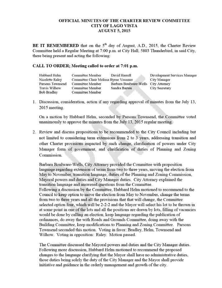
256 256
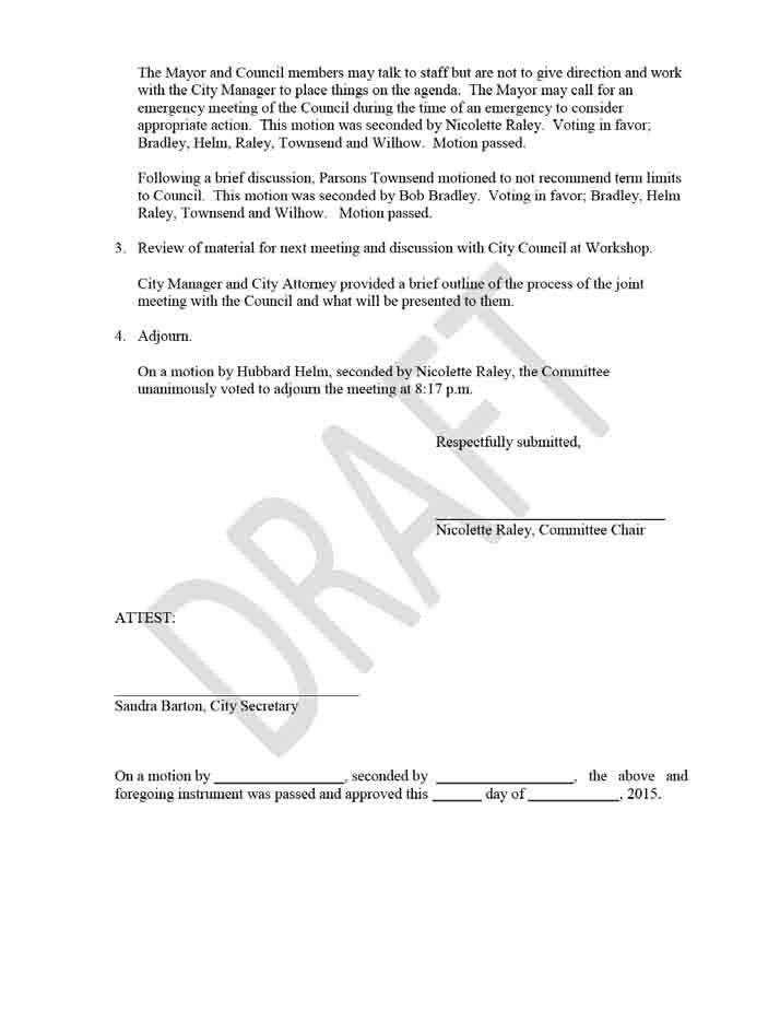
257 257
258 258
259 259
260 260
261 261
262 262
SERVICE AND ASSESSMENT PLAN CITY OF HASLET PUBLIC IMPROVEMENT DISTRICT NO. 2 SERVICE AND ASSESSMENT PLAN August 3, \ v
 SERVICE AND ASSESSMENT PLAN CITY OF HASLET PUBLIC IMPROVEMENT DISTRICT NO. 2 SERVICE AND ASSESSMENT PLAN August 3, 2015 CITY OF HASLET PUBLIC IMPROVEMENT DISTRICT NO. 2 SERVICE AND ASSESSMENT PLAN Table
RIVENDALE POINTE PUBLIC IMPROVEMENT DISTRICT SERVICE AND ASSESSMENT PLAN. August 9, MuniCap v 1.6
 RIVENDALE POINTE PUBLIC IMPROVEMENT DISTRICT SERVICE AND ASSESSMENT PLAN August 9, 2016 MuniCap v 1.6 RIVENDALE POINTE PUBLIC IMPROVEMENT DISTRICT SERVICE AND ASSESSMENT PLAN Table of Contents Section
ORDINANCE NUMBER 1154
 ORDINANCE NUMBER 1154 AN ORDINANCE OF THE CITY COUNCIL OF THE CITY OF PERRIS ACTING AS THE LEGISLATIVE BODY OF COMMUNITY FACILITIES DISTRICT NO. 2005-1 (PERRIS VALLEY VISTAS) OF THE CITY OF PERRIS AUTHORIZING
RESOLUTION NUMBER 3970
 RESOLUTION NUMBER 3970 A RESOLUTION OF THE CITY COUNCIL OF THE CITY OF PERRIS, COUNTY OF RIVERSIDE, STATE OF CALIFORNIA, AUTHORIZING THE CHANGES TO THE FACILITIES AND SPECIAL TAXES WITHIN IMPROVEMENT AREA
CIMARRON HILLS PUBLIC IMPROVEMENT DISTRICT SERVICE AND ASSESSMENT PLAN 2012 UPDATE
 CIMARRON HILLS PUBLIC IMPROVEMENT DISTRICT SERVICE AND ASSESSMENT PLAN 2012 UPDATE Introduction Sections 372.013 372.014 of Chapter 372 of the Local Government Code known as the Public Improvement District
RATE AND METHOD OF APPORTIONMENT FOR CASITAS MUNICIPAL WATER DISTRICT COMMUNITY FACILITIES DISTRICT NO (OJAI)
") RATE AND METHOD OF APPORTIONMENT FOR CASITAS MUNICIPAL WATER DISTRICT COMMUNITY FACILITIES DISTRICT NO. 2013-1 (OJAI) A Special Tax shall be levied on all Assessor s Parcels of Taxable Property in Casitas
RATE AND METHOD OF APPORTIONMENT FOR CASITAS MUNICIPAL WATER DISTRICT COMMUNITY FACILITIES DISTRICT NO. 2013-1 (OJAI) A Special Tax shall be levied on all Assessor s Parcels of Taxable Property in Casitas
RESOLUTION NUMBER 3992
 RESOLUTION NUMBER 3992 A RESOLUTION OF THE CITY COUNCIL OF THE CITY OF PERRIS AUTHORIZING THE CHANGES TO THE SPECIAL TAXES WITHIN COMMUNITY FACILITIES DISTRICT NO. 2006-3 (ALDER) OF THE CITY OF PERRIS;
PROPERTY; PROVIDING FOR EXPENDITURE OF REVENUE; PROVIDING FOR REIMBURSEMENT
 ORDINANCE NO. 12- AN ORDINANCE OF MARION COUNTY, FLORIDA ESTABLISHING THE RAINBOW PARK UNITS 1 & 2 MUNICIPAL SERVICE BENEFIT UNIT FOR ROAD MAINTENANCE; PROVIDING FOR A PURPOSE; PROVIDING FOR THE POWERS
MARION COUNTY, FLORIDA LAKE TROPICANA RANCHETTES (PHASE I) RE-ASSESSMENT IMPROVEMENT AREA INITIAL ASSESSMENT RESOLUTION
 RE-ASSESSMENT IMPROVEMENT AREA INITIAL ASSESSMENT RESOLUTION") MARION COUNTY, FLORIDA LAKE TROPICANA RANCHETTES (PHASE I) RE-ASSESSMENT IMPROVEMENT AREA INITIAL ASSESSMENT RESOLUTION ADOPTED JULY 20, 2010 TABLE OF CONTENTS PAGE ARTICLE I DEFINITIONS AND CONSTRUCTION
MARION COUNTY, FLORIDA LAKE TROPICANA RANCHETTES (PHASE I) RE-ASSESSMENT IMPROVEMENT AREA INITIAL ASSESSMENT RESOLUTION ADOPTED JULY 20, 2010 TABLE OF CONTENTS PAGE ARTICLE I DEFINITIONS AND CONSTRUCTION
RESOLUTION NUMBER 3968
 RESOLUTION NUMBER 3968 A RESOLUTION OF THE CITY COUNCIL OF THE CITY OF PERRIS, COUNTY OF RIVERSIDE, STATE OF CALIFORNIA, AS THE LEGISLATIVE BODY OF COMMUNITY FACILITIES DISTRICT NO. 2001-1 (MAY FARMS)
ORDINANCE NO
 ORDINANCE NO. 2014-160 AN ORDINANCE OF THE CITY COUNCIL OF THE CITY OF MENIFEE, CALIFORNIA, REPEALING SECTION 10.35 OF RIVERSIDE COUNTY LAND USE ORDINANCE NO. 460.152 AS ADOPTED BY THE CITY OF MENIFEE
ORDINANCE AN ORDINANCE TO AMEND SPRING HILL MUNICIPAL CODE, CHAPTER 5, IMPACT FEE-PURPOSES AND ADMINISTRATION
 ORDINANCE 15-04 AN ORDINANCE TO AMEND SPRING HILL MUNICIPAL CODE, CHAPTER 5, IMPACT FEE-PURPOSES AND ADMINISTRATION WHEREAS, the Board of Mayor and Aldermen for the City of Spring Hill may, pursuant to
TOWN OF PALM BEACH Information for Town Council Meeting on: July 12, 2017
 TOWN OF PALM BEACH Information for Town Council Meeting on: July 12, 2017 To: Via: Mayor and Town Council Thomas G. Bradford, Town Manager From: Jane Struder, Director of Finance Re: Town-wide Undergrounding
Mayor Leon Skip Beeler and Members of the City Commission. Anthony Caravella, AICP, Director of Development Services
 CITY COMMISSION BRIEFING & Planning Board Report For Meeting Scheduled for November 4, 2010 Thousand Island Conservation Area Rezoning Ordinance 1519 FINAL ACTION TO: FROM: THRU: RE: Mayor Leon Skip Beeler
ORDINANCE NO
 ORDINANCE NO. 2016-23 AUTHORIZING THE CREATION OF THE BALLPARK VILLAGE MUNICIPAL IMPROVEMENT DISTRICT; PROVIDING FOR THE FINANCING OF IMPROVEMENTS WITHIN THE BALLPARK VILLAGE MUNICIPAL IMPROVEMENT DISTRICT
LOCAL GOVERNMENT CODE CHAPTER 372. IMPROVEMENT DISTRICTS IN MUNICIPALITIES AND COUNTIES SUBCHAPTER A. PUBLIC IMPROVEMENT DISTRICTS
 LOCAL GOVERNMENT CODE CHAPTER 372. IMPROVEMENT DISTRICTS IN MUNICIPALITIES AND COUNTIES SUBCHAPTER A. PUBLIC IMPROVEMENT DISTRICTS Sec. 372.001. SHORT TITLE. This subchapter may be cited as the Public
THE CITY OF LAKE FOREST ORDINANCE NO. AN ORDINANCE AMENDING THE LAKE FOREST CITY CODE TO ESTABLISH A HOUSING TRUST FUND BOARD
 THE CITY OF LAKE FOREST ORDINANCE NO. AN ORDINANCE AMENDING THE LAKE FOREST CITY CODE TO ESTABLISH A HOUSING TRUST FUND BOARD WHEREAS, the State of Illinois has enacted the Affordable Housing and Appeal
INSTALLMENT PURCHASE AGREEMENT
 INSTALLMENT PURCHASE AGREEMENT by and between COUNTY SANITATION DISTRICT NO. 14 OF LOS ANGELES COUNTY and LOS ANGELES COUNTY SANITATION DISTRICTS FINANCING AUTHORITY Dated as of 1, 2015 TABLE OF CONTENTS
Water System Master Operating Agreement. for the. Marion, Howell, Oceola and Genoa. Sewer and Water Authority
 Water System Master Operating Agreement for the Marion, Howell, Oceola and Genoa Sewer and Water Authority Dated as of February 1, 2011 TABLE OF CONTENTS Page ARTICLE I DEFINITIONS Section 1.1 Definitions...2
FINANCE DEPARTMENT M E M O R A N D U M
 FINANCE DEPARTMENT M E M O R A N D U M TO: FROM: BY: Honorable Mayor and City Commission Ambreen Bhatty, City Manager Steven Chapman II, Finance Director DATE: June 25, 2013 SUBJECT: Solid Waste Assessment
REPORT OF SPECIAL TAX LEVY FOR THE CITY OF LAKE ELSINORE. CITY OF LAKE ELSINORE CFD (Rosetta Canyon Public Improvements) Fiscal Year
 Fiscal Year") REPORT OF SPECIAL TAX LEVY FOR THE CITY OF LAKE ELSINORE CITY OF LAKE ELSINORE CFD 2004-3 (Rosetta Canyon Public Improvements) Fiscal Year 2006-07 Submitted to: City of Lake Elsinore Riverside County,
REPORT OF SPECIAL TAX LEVY FOR THE CITY OF LAKE ELSINORE CITY OF LAKE ELSINORE CFD 2004-3 (Rosetta Canyon Public Improvements) Fiscal Year 2006-07 Submitted to: City of Lake Elsinore Riverside County,
AGENDA COLLETON COUNTY COUNCIL REGULAR MEETING TUESDAY, FEBRUARY 5, :00 P.M. COUNTY COUNCIL CHAMBERS, OLD JAIL BUILDING
 AGENDA COLLETON COUNTY COUNCIL REGULAR MEETING TUESDAY, FEBRUARY 5, 2013 6:00 P.M. COUNTY COUNCIL CHAMBERS, OLD JAIL BUILDING 1. Call to Order 2. Invocation 3. Present Colors and Lead Pledge of Allegiance-
ORDINANCE WHEREAS, this title is intended to implement and be consistent with the county comprehensive plan; and
 ORDINANCE 2005-015 AN ORDINANCE OF THE BOARD OF COUNTY COMMISSIONERS OF INDIAN RIVER COUNTY, FLORIDA, ADOPTING TITLE X, IMPACT FEES, AND AMENDING CODE SECTION 953, FAIR SHARE ROADWAY IMPROVEMENTS, OF THE
A PUBLIC RIGHT-OF-WAY MANAGEMENT ORDINANCE BY THE CITY OF SOUTHLAKE, TEXAS; REGULATING THE PHYSICAL USE, OCCUPANCY AND MAINTENANCE
 ORDINANCE NO. 1178 A PUBLIC RIGHT-OF-WAY MANAGEMENT ORDINANCE BY THE CITY OF SOUTHLAKE, TEXAS; REGULATING THE PHYSICAL USE, OCCUPANCY AND MAINTENANCE OF CITY RIGHTS-OF-WAY BY WIRELESS NETWORK PROVIDERS;
Referred to Committee on Taxation. SUMMARY Revises provisions governing the collection of delinquent property taxes. (BDR )
") ASSEMBLY BILL NO. COMMITTEE ON TAXATION (ON BEHALF OF CLARK COUNTY) PREFILED NOVEMBER 0, 0 Referred to Committee on Taxation A.B. SUMMARY Revises provisions governing the collection of delinquent property
ASSEMBLY BILL NO. COMMITTEE ON TAXATION (ON BEHALF OF CLARK COUNTY) PREFILED NOVEMBER 0, 0 Referred to Committee on Taxation A.B. SUMMARY Revises provisions governing the collection of delinquent property
Exhibit E Meyers Nave Draft 2/12/14 ESCROW AGREEMENT. by and between the SUCCESSOR AGENCY TO THE REDEVELOPMENT AGENCY OF THE CITY OF PITTSBURG.
 Exhibit E Meyers Nave Draft 2/12/14 ESCROW AGREEMENT by and between the SUCCESSOR AGENCY TO THE REDEVELOPMENT AGENCY OF THE CITY OF PITTSBURG and THE BANK OF NEW YORK MELLON TRUST COMPANY, N.A. as Escrow
ESCROW AGREEMENT. Dated, Relating to
 CITY OF ANAHEIM, CALIFORNIA and U.S. BANK NATIONAL ASSOCIATION, Escrow Agent ESCROW AGREEMENT Dated, 2014 Relating to Certificates of Participation (1993 Land Acquisition Refinancing Project) Evidencing
Administration Report Fiscal Year 2016/2017. Hesperia Unified School District Community Facilities District No June 20, 2016.
 Administration Report Fiscal Year 2016/2017 Hesperia Unified School District Community Facilities District No. 2006-2 June 20, 2016 Prepared For: Hesperia Unified School District 15576 Main Street Hesperia,
ACQUISITION AGREEMENT
 Quint & Thimmig LLP ACQUISITION AGREEMENT by and between the CITY OF ALAMEDA, CALIFORNIA and CATELLUS ALAMEDA DEVELOPMENT, LLC dated as of 1, 2013 relating to: City of Alameda Community Facilities District
RATE AND METHOD OF APPORTIONMENT FOR COMMUNITY FACILITIES DISTRICT NO. 3 (SEABRIDGE AT MANDALAY BAY) OF THE CITY OF OXNARD
 OF THE CITY OF OXNARD") RATE AND METHOD OF APPORTIONMENT FOR COMMUNITY FACILITIES DISTRICT NO. 3 (SEABRIDGE AT MANDALAY BAY) OF THE CITY OF OXNARD A Special Tax as hereinafter defined shall be levied on all Assessor s Parcels
RATE AND METHOD OF APPORTIONMENT FOR COMMUNITY FACILITIES DISTRICT NO. 3 (SEABRIDGE AT MANDALAY BAY) OF THE CITY OF OXNARD A Special Tax as hereinafter defined shall be levied on all Assessor s Parcels
AMENDED AND RESTATED MEMORANDUM OF UNDERSTANDING
 AMENDED AND RESTATED MEMORANDUM OF UNDERSTANDING THIS AMENDED AND RESTATED MEMORANDUM OF UNDERSTANDING (this Memorandum ) is made as of this day of, 2011, by and between the COUNTY OF FAIRFAX, VIRGINIA
ORDINANCE NO. C-590(E0916)
") ORDINANCE NO. C-590(E0916) AN ORDINANCE AMENDING THE WATER AND WASTEWATER IMPACT FEES ORDINANCE NO. C-590(D0314) RELATING TO THE REGULATION OF THE USE AND DEVELOPMENT OF LAND IN THE INCORPORATED LIMITS
ORDINANCE NO. C-590(E0916) AN ORDINANCE AMENDING THE WATER AND WASTEWATER IMPACT FEES ORDINANCE NO. C-590(D0314) RELATING TO THE REGULATION OF THE USE AND DEVELOPMENT OF LAND IN THE INCORPORATED LIMITS
AVENIR COMMUNITY DEVELOPMENT DISTRICT
 AVENIR COMMUNITY DEVELOPMENT DISTRICT CITY OF PALM BEACH GARDENS REGULAR BOARD MEETING & PUBLIC HEARING JANUARY 25, 2018 12:00 P.M. Special District Services, Inc. The Oaks Center 2501A Burns Road Palm
TOWN OF AVON, COLORADO ORDINANCE NO SERIES OF 2014
 TOWN OF AVON, COLORADO ORDINANCE NO. 14-17 SERIES OF 2014 AN ORDINANCE AUTHORIZING THE FINANCING OF CERTAIN PUBLIC IMPROVEMENTS OF THE TOWN, AND IN CONNECTION THEREWITH AUTHORIZING THE LEASING OF CERTAIN
******************************************************************************
 AN ORDINANCE OF THE CITY COUNCIL OF THE CITY OF BAYTOWN, TEXAS, EXCLUDING LAND FROM REINVESTMENT ZONE NO. ONE, CITY OF BAYTOWN, TEXAS; INCLUDING LAND WITHIN THE ZONE; EXTENDING THE TERM OF SUCH ZONE; APPROVING
ORDINANCE NO AN ORDINANCE AMENDING THE CODE OF ORDINANCES OF THE CITY OF PORT ARANSAS, TEXAS, BY ADOPTING A NEW CHAPTER
 ORDINANCE NO. 2008-09 AN ORDINANCE AMENDING THE CODE OF ORDINANCES OF THE CITY OF PORT ARANSAS, TEXAS, BY ADOPTING A NEW CHAPTER TWENTY-SIX CONCERNING IMPACT FEES FOR ROADWAY FACILITIES; INCORPORATING
RESOLUTION NUMBER 3928
 RESOLUTION NUMBER 3928 RESOLUTION OF CONSIDERATION OF THE CITY COUNCIL OF THE CITY OF PERRIS, COUNTY OF RIVERSIDE, STATE OF CALIFORNIA, ACTING AS THE LEGISLATIVE BODY OF COMMUNITY FACILITIES DISTRICT NO.
City Commission Agenda Cover Memorandum
 City Commission Agenda Cover Memorandum Originating Department: Mayor/Admin (MA) Meeting Type: Regular Agenda Date: 01/30/2017 Advertised: Required?: Yes No ACM#: 21226 Subject: Public Hearing and First
TOWNSHIP COUNCIL AGENDA REGULAR MEETING 7:00 P.M. September 17, 2018 Municipal Building, 600 Bloomfield Avenue
 ### Consent Agenda R # 114 *** Requires 2/3 Affirmative Confirmation O # 25 TOWNSHIP COUNCIL AGENDA REGULAR MEETING 7:00 P.M. September 17, 2018 Municipal Building, 600 Bloomfield Avenue A. CALL TO ORDER
POWAY UNIFIED SCHOOL DISTRICT ADMINISTRATION REPORT FISCAL YEAR 2017/2018 IMPROVEMENT AREA NO. 1 OF COMMUNITY FACILITIES DISTRICT NO.
 POWAY UNIFIED SCHOOL DISTRICT ADMINISTRATION REPORT FISCAL YEAR 2017/2018 IMPROVEMENT AREA NO. 1 OF COMMUNITY FACILITIES DISTRICT NO. 2 JUNE 29, 2017 PREPARED FOR: Poway Unified School District Planning
Senate Bill No. 301 Senator Smith
 Senate Bill No. 301 Senator Smith CHAPTER... AN ACT relating to taxation; requiring a county treasurer to assign a tax lien against a parcel of real property located within the county if an assignment
ORDINANCE NO
 ORDINANCE NO. 2008-26 AN ORDINANCE CREATING A MUNICIPAL SERVICE BENEFIT UNIT TO BE KNOWN AS THE "FLOCK AVENUE ROAD PAVING MUNICIPAL SERVICE BENEFIT UNIT"; PROVIDING FOR THE PURPOSE OF THE UNIT; PROVIDING
Middle Village Community Development District
 Middle Village Community Development District 475 West Town Place Suite 114 St. Augustine, Florida 32092 February 26, 2018 Board of Supervisors Middle Village Community Development District Staff Call
RESOLUTION NUMBER 4779
 RESOLUTION NUMBER 4779 RESOLUTION OF INTENTION OF THE CITY COUNCIL OF THE CITY OF PERRIS TO ESTABLISH COMMUNITY FACILITIES DISTRICT NO. 2014-1 (AVELINA) OF THE CITY OF PERRIS AND TO AUTHORIZE THE LEVY
Community Facilities District Report. Jurupa Unified School District Community Facilities District No. 13. September 14, 2015
 Community Facilities District Report Jurupa Unified School District Community Facilities District No. 13 September 14, 2015 Prepared For: Jurupa Unified School District 4850 Pedley Road Jurupa Valley,
PINELLAS COUNTY, FLORIDA FINAL SURFACE WATER RATE RESOLUTION
 PINELLAS COUNTY, FLORIDA FINAL SURFACE WATER RATE RESOLUTION ADOPTED SEPTEMBER 10, 2013 TABLE OF CONTENTS Page SECTION 1. AUTHORITY.... 2 SECTION 2. DEFINITIONS.... 3 SECTION 3. CONFIRMATION OF INITIAL
ORDINANCE NO NOW THEREFORE the Council of the City of Flowery Branch hereby ordains as follows:
 First Reading: 6/20/2018 Second Reading: 6/20/2018 Third Reading: 6/28/2018 ORDINANCE NO. 549 AN ORDINANCE TO FIX THE AD VALOREM TAX RATE FOR THE CITY OF FLOWERY BRANCH, GEORGIA FOR THE TAX YEAR 2018 AND
S U B D I V I S I O N AGREEMENT
 S U B D I V I S I O N AGREEMENT THIS AGREEMENT made this 17th day of January, 2006, by and between Peachtree Properties, L.L.C., (hereinafter referred to as "Developer"); SANITARY AND IMPROVEMENT DISTRICT
CITY AND COUNTY OF HONOLULU DEPARTMENT OF BUDGET & FISCAL SERVICES ADMINISTRATIVE GUIDELINES FOR COMMUNITY FACILITIES DISTRICTS
 Working Draft of May 14, 2004 Working Draft of August 11, 2004 Working Draft of September 8, 2004 CITY AND COUNTY OF HONOLULU DEPARTMENT OF BUDGET & FISCAL SERVICES ADMINISTRATIVE GUIDELINES FOR COMMUNITY
ORDINANCE NO OA
 ORDINANCE NO. 2013 11-OA AN ORDINANCE OF THE TOWNSHIP OF BERKELEY, COUNTY OF OCEAN, STATE OF NEW JERSEY, AMENDING THE TOWNSHIP CODE OF THE TOWNSHIP OF BERKELEY, SO AS TO CREATE ARTICLE XX, ENTITLED VOLUNTARY
ONTARIO INTERNATIONAL AIRPORT AUTHORITY
 ONTARIO INTERNATIONAL AIRPORT AUTHORITY COMMISSION AGENDA REGULAR MEETING APRIL 23, 2019 AT 3:00 P.M. Ontario International Airport Administration Offices 1923 E. Avion Street, Room 100, Ontario, CA 91761
Public Improvement District (PID) Policy
 Policy") Public Improvement District (PID) Policy OVERVIEW Public Improvement Districts ( PIDs ), per the Texas Local Government Code Chapter 372 ( the code or PID Act ), provide the City of Marble Falls ( the
Public Improvement District (PID) Policy OVERVIEW Public Improvement Districts ( PIDs ), per the Texas Local Government Code Chapter 372 ( the code or PID Act ), provide the City of Marble Falls ( the
ORDINANCE NO Page 1 of7. Ordinance 2866 April 13, 2010 April 27, 2010
 ORDINANCE NO. 2866 AN ORDINANCE OF THE CITY OF HOLLY HILL, FLORIDA, CREATING ARTICLE IV (SPECIAL ASSESSMENT) AUTHORIZING THE IMPOSITION AND LEVY OF SPECIAL ASSESSMENTS FOR ADMINISTRATIVE COSTS INCURRED
CITY OF PITTSBURG, KANSAS COMMUNITY IMPROVEMENT DISTRICT POLICY I. PURPOSE
 CITY OF PITTSBURG, KANSAS COMMUNITY IMPROVEMENT DISTRICT POLICY I. PURPOSE The Governing Body of the City of Pittsburg, Kansas (" The Governing Body") is authorized by the Community Improvement District
TOWNSHIP OF EDENVILLE COUNTY OF MIDLAND STATE OF MICHIGAN ORDINANCE NO. 178 LAND DIVISION ORDINANCE TOWNSHIP OF EDENVILLE
 TOWNSHIP OF EDENVILLE COUNTY OF MIDLAND STATE OF MICHIGAN ORDINANCE NO. 178 LAND DIVISION ORDINANCE An ordinance to regulate partitioning or division of parcels or tracts of land, enacted pursuant but
Monroe County, Tennessee Property Tax Incentive Program Policies and Procedures
 Monroe County, Tennessee Property Tax Incentive Program Policies and Procedures Revised 1/2010 MONROE COUNTY, TENNESSEE PROPERTY TAX INCENTIVE PROGRAM POLICIES AND PROCEDURES Section I General Purpose
Revised April 26, 2012 April 30, 2012
 BOARD OF EDUCATION OF HARFORD COUNTY A DECISION ON REFINANCING THE A.A. ROBERTY BUILDING CERTIFICATES OF PARTICIPATION AND THE HARFORD COUNTY PHASE I AND PHASE II ENERGY LEASES DATED 1//001 AND 1/1/00
201 General Provisions
 201 General Provisions 201.01 Title 201.09 Amendments 201.02 Purpose and Intent 201.10 Public Purpose 201.03 Authority 201.11 Variances and Appeals 201.04 Jurisdiction 201.12 Nonconformances 201.05 Enactment
ASSIGNMENT OF LEASES AND RENTS
 ASSIGNMENT OF LEASES AND RENTS THIS ASSIGNMENT OF LEASES AND RENTS (as the same may be amended, modified or supplemented from time to time, the Assignment ), dated as of the day of, 2011, from Four-G,
Table of Contents. Sections. Tables. Appendices
 - Table of Contents Sections Section 1. Bond Profile 1 Section 2. Fund Information 2 Section 3. Special Tax Information 3 Section 4. Owner and Development Status Information 4 Section 5. Payment History
TRUCKEE FIRE PROTECTION DISTRICT ORDINANCE
 TRUCKEE FIRE PROTECTION DISTRICT ORDINANCE 01-2017 AN ORDINANCE OF THE BOARD OF DIRECTORS OF THE TRUCKEE FIRE PROTECTION DISTRICT LEVYING SPECIAL TAXES WITHIN COMMUNITY FACILITIES DISTRICT NO. 2017-01
Oregon Statutes Relevant to Quiet Water Home Owners Association
 Oregon Statutes Relevant to Quiet Water Home Owners Association 1 1 1 1 0 1 0 1 0 1 PLANNED COMMUNITIES (General Provisions).0 Definitions for ORS.0 to.. As used in ORS.0 to.: (1) Assessment means any
Amending Chapter 9 Establishment of Fees, Section 9.04 Ambulance Service Fees. (Second Reading)
") DATE: July 20, 2016 TO: FROM: SUBJECT: Honorable Mayor John Rey City Council Anne Marie Gaura, City Manager Cathy Haley, Finance Director Amending Chapter 9 Establishment of, Section 9.04 Ambulance Service.
DATE: July 20, 2016 TO: FROM: SUBJECT: Honorable Mayor John Rey City Council Anne Marie Gaura, City Manager Cathy Haley, Finance Director Amending Chapter 9 Establishment of, Section 9.04 Ambulance Service.
SPECIAL TAX AND BOND ACCOUNTABILITY REPORT
 SPECIAL TAX AND BOND ACCOUNTABILITY REPORT FOR IMPROVEMENT AREA A OF COMMUNITY FACILITIES DISTRICT NO. 10 OF THE POWAY UNIFIED SCHOOL DISTRICT November 14, 2003 SPECIAL TAX AND BOND ACCOUNTABILITY REPORT
PALM BEACH COUNTY BOARD OF COUNTY COMMISSIONERS AGENDA ITEM SUMMARY. September 10, 2013 [ ] Consent [X] Regular [ ] Ordinance [ ] Public Hearing
![PALM BEACH COUNTY BOARD OF COUNTY COMMISSIONERS AGENDA ITEM SUMMARY. September 10, 2013 [ ] Consent [X] Regular [ ] Ordinance [ ] Public Hearing](/thumbs/88/117540312.jpg "PALM BEACH COUNTY BOARD OF COUNTY COMMISSIONERS AGENDA ITEM SUMMARY. September 10, 2013 [ ] Consent [X] Regular [ ] Ordinance [ ] Public Hearing") Agenda Item#: 50 \ PALM BEACH COUNTY BOARD OF COUNTY COMMISSIONERS AGENDA ITEM SUMMARY Meeting Date: Department: September 10, 2013 [ ] Consent [X] Regular [ ] Ordinance [ ] Public Hearing Department of
Agenda Item#: 50 \ PALM BEACH COUNTY BOARD OF COUNTY COMMISSIONERS AGENDA ITEM SUMMARY Meeting Date: Department: September 10, 2013 [ ] Consent [X] Regular [ ] Ordinance [ ] Public Hearing Department of
ORDINANCE NO O AN ORDINANCE PROVIDING FOR THE CREATION OF LOCAL IMPROVEMENT DISTRICTS; AND REPEALING ORDINANCE NO. 305, 315 AND 367.
 2-3 2-3.2 ORDINANCE NO. 99-539-O AN ORDINANCE PROVIDING FOR THE CREATION OF LOCAL IMPROVEMENT DISTRICTS; AND REPEALING ORDINANCE NO. 305, 315 AND 367. RECITALS: WHEREAS, the voters of the State of Oregon
SUMTER COUNTY BOARD OF COMMISSIONERS EXECUTIVE SUMMARY. Managing Division / Dept: Office of Management & Budget
 SUMTER COUNTY BOARD OF COMMISSIONERS EXECUTIVE SUMMARY SUBJECT: Public Hearing - Annual Assessment Resolution and Establishment of Fees for the Sumter County Fire District (MSBU). REQUESTED ACTION: Staff
HILLCREST COMMUNITY DEVELOPMENT DISTRICT BROWARD COUNTY REGULAR BOARD MEETING APRIL 19, :00 P.M.
 HILLCREST COMMUNITY DEVELOPMENT DISTRICT BROWARD COUNTY REGULAR BOARD MEETING APRIL 19, 2018 2:00 P.M. Special District Services, Inc. The Oaks Center 2501A Burns Road Palm Beach Gardens, FL 33410 www.hillcrestcdd.org
ESCROW AGREEMENT. Defeasance of 2018 and 2019 Maturities of 2005 Bonds. between SCHOOL DISTRICT NO. 414 (KIMBERLY), TWIN FALLS COUNTY, IDAHO.
, TWIN FALLS COUNTY, IDAHO.") ESCROW AGREEMENT Defeasance of 2018 and 2019 Maturities of 2005 Bonds between SCHOOL DISTRICT NO. 414 (KIMBERLY), TWIN FALLS COUNTY, IDAHO and U.S. BANK NATIONAL ASSOCIATION, as Escrow Agent Dated effective
ESCROW AGREEMENT Defeasance of 2018 and 2019 Maturities of 2005 Bonds between SCHOOL DISTRICT NO. 414 (KIMBERLY), TWIN FALLS COUNTY, IDAHO and U.S. BANK NATIONAL ASSOCIATION, as Escrow Agent Dated effective
SENATE BILL 274 CHAPTER. Tax Increment Financing and Special Taxing Districts Transit Oriented Development
 SENATE BILL C, Q lr0 CF HB 00 By: The President (By Request Administration) Introduced and read first time: January, 0 Assigned to: Budget and Taxation Committee Report: Favorable with amendments Senate
2/16/2016. City Council City Hall Wilmington, North Carolina Dear Mayor and Councilmembers:
 ITEM O1 2/16/2016 OFFICE OF THE CITY MANAGER (910) 341-7810 FAX(910)341-5839 TDD (910)341-7873 City Council City Hall Wilmington, North Carolina 28401 Dear Mayor and Councilmembers: Attached for your consideration
SPECIAL TAX AND BOND ACCOUNTABILITY REPORT
 SPECIAL TAX AND BOND ACCOUNTABILITY REPORT FOR IMPROVEMENT AREA A OF COMMUNITY FACILITIES DISTRICT NO. 6 OF THE POWAY UNIFIED SCHOOL DISTRICT November 14, 2003 SPECIAL TAX AND BOND ACCOUNTABILITY REPORT
Harris Ranch Community Infrastructure District No. 1. Feasibility Report Special Assessment Bonds (Assessment Area One)
") Harris Ranch Community Infrastructure District No. 1 Feasibility Report Special Assessment Bonds (Assessment Area One) September 21, 2010 Submitted By: Mr. Doug Fowler Lenir, Ltd. 4940 East Mill Station
Harris Ranch Community Infrastructure District No. 1 Feasibility Report Special Assessment Bonds (Assessment Area One) September 21, 2010 Submitted By: Mr. Doug Fowler Lenir, Ltd. 4940 East Mill Station
JH:SRF:JMG:brf AGENDA DRAFT 4/06/2016 ESCROW AGREEMENT
 23090-12 JH:SRF:JMG:brf AGENDA DRAFT 4/06/2016 ESCROW AGREEMENT THIS ESCROW AGREEMENT (the Agreement ) is dated as of May 1, 2016, and is entered into by and between the MT. DIABLO UNIFIED SCHOOL DISTRICT
TOWNSHIP OF WOOLWICH BOND ORDINANCE NUMBER
 TOWNSHIP OF WOOLWICH BOND ORDINANCE NUMBER 2017-11 REFUNDING BOND ORDINANCE OF THE TOWNSHIP OF WOOLWICH, IN THE COUNTY OF GLOUCESTER, STATE OF NEW JERSEY (THE TOWNSHIP ) PROVIDING FOR (i) THE REFUNDING
AVENIR COMMUNITY DEVELOPMENT DISTRICT CITY OF PALM BEACH GARDENS SPECIAL BOARD MEETING MARCH 27, :00 P.M.
 AVENIR COMMUNITY DEVELOPMENT DISTRICT CITY OF PALM BEACH GARDENS SPECIAL BOARD MEETING MARCH 27, 2018 12:00 P.M. Special District Services, Inc. The Oaks Center 2501A Burns Road Palm Beach Gardens, FL
SECOND AMENDED RATE AND METHOD OF APPORTIONMENT OF SPECIAL TAXES FOR TUSTIN UNIFIED SCHOOL DISTRICT COMMUNITY FACILITIES DISTRICT NO
 SECOND AMENDED RATE AND METHOD OF APPORTIONMENT OF SPECIAL TAXES FOR TUSTIN UNIFIED SCHOOL DISTRICT COMMUNITY FACILITIES DISTRICT NO. 07-1 (ORCHARD HILLS) A Special Tax shall be levied and collected within
City of Titusville "Gateway to Nature and Space"
 City of Titusville "Gateway to Nature and Space" Category: 10. Item: A. To: From: Subject: REPORT TO COUNCIL The Honorable Mayor and City Council Peggy Busacca, Community Development Director Ordinance
EXTRACTS FROM MINUTES OF MEETING OF THE BOARD OF TRUSTEES OF THE VILLAGE OF MAMARONECK, COUNTY OF WESTCHESTER, STATE OF NEW YORK
 EXTRACTS FROM MINUTES OF MEETING OF THE BOARD OF TRUSTEES OF THE VILLAGE OF MAMARONECK, COUNTY OF WESTCHESTER, STATE OF NEW YORK (Refunding Bond Resolution, 2019) A regular meeting of the Board of Trustees
CITY OF CORAL GABLES, FLORIDA FIRE PROTECTION ASSESSMENT ORDINANCE FIRST READING JULY 29, 2009
 CITY OF CORAL GABLES, FLORIDA FIRE PROTECTION ASSESSMENT ORDINANCE FIRST READING JULY 29, 2009 SECOND READING AUGUST 25, 2009 TABLE OF CONTENTS PAGE ARTICLE I INTRODUCTION SECTION 1.01. DEFINITIONS....
NOW THEREFORE, BE IT ORDAINED BY THE BOARD OF COUNTY COMMISSIONERS. Adoption of Transferable Development Rights Land Development
 NOW THEREFORE, BE IT ORDAINED BY THE BOARD OF COUNTY COMMISSIONERS OF ST. LUCIE COUNTY, FLORIDA, AS FOLLOWS: Section 1. Recitals Adopted. Each of the above stated recitals is hereby adopted and confirmed.
Public Portion: Mr. Bianchini opened the public portion. There being no comment, the public portion was closed. Resolutions:
 GLOUCESTER TOWNSHIP SPECIAL COUNCIL MEETING DECEMBER 1, 2008 MUNICIPAL BUILDING, CHEWS LANDING NEW JERSEY Pledge Allegiance to the Flag Statement: Mr. Bianchini read a statement setting forth the time,
1 ORDINANCE 4, AN ORDINANCE OF THE CITY COUNCIL OF THE CITY OF PALM 5 BEACH GARDENS, FLORIDA AMENDING CHAPTER TAXATION.
 1 ORDINANCE 4, 2013 2 3 4 AN ORDINANCE OF THE CITY COUNCIL OF THE CITY OF PALM 5 BEACH GARDENS, FLORIDA AMENDING CHAPTER 66. 6 TAXATION. BY CREATING A NEW ARTICLE VI. ENTITLED 7 ECONOMIC DEVELOPMENT AD
SPECIAL ASSESSMENT AGREEMENT AND DECLARATION OF NOTICE OF SPECIAL ASSESSMENT
 Attachment 7A: Form of Special Assessment Agreement SPECIAL ASSESSMENT AGREEMENT AND DECLARATION OF NOTICE OF SPECIAL ASSESSMENT THIS SPECIAL ASSESSMENT AGREEMENT AND DECLARATION OF NOTICE OF SPECIAL ASSESSMENT
BYLAW a) To impose and provide for the payment of Off-site development levies;
 To impose and provide for the payment of Off-site development levies;") BYLAW 2018-3388 A Bylaw of the City of Weyburn, in the Province of Saskatchewan to establish an Off-Site Development Levy in respect of land that is to be subdivided, developed or redeveloped within the
BYLAW 2018-3388 A Bylaw of the City of Weyburn, in the Province of Saskatchewan to establish an Off-Site Development Levy in respect of land that is to be subdivided, developed or redeveloped within the
ORDINANCE NO. 875 (AS AMENDED THROUGH 875
 ORDINANCE NO. 875 (AS AMENDED THROUGH 875.1) AN ORDINANCE OF THE COUNTY OF RIVERSIDE TO ESTABLISH A LOCAL DEVELOPMENT MITIGATION FEE FOR FUNDING THE PRESERVATION OF NATURAL ECOSYSTEMS IN ACCORDANCE WITH
ESCROW INSTRUCTIONS RECITALS
 HDW 6/8/15 Draft ESCROW INSTRUCTIONS These Escrow Instructions, dated as of July 1, 2015 (the Escrow Instructions ), are directed to WELLS FARGO BANK, NATIONAL ASSOCIATION, as escrow agent (the Escrow
LEASE-LEASEBACK SUBLEASE AGREEMENT. Dated as of April 1, Between. Newark Unified School District. and. Environmental Systems, Inc.
 LEASE-LEASEBACK SUBLEASE AGREEMENT Dated as of April 1, 2014 Between Newark Unified School District and Environmental Systems, Inc., Phase 1 District-Wide {SR134676.DOC} LEASE-LEASEBACK SUBLEASE AGREEMENT
POWAY UNIFIED SCHOOL DISTRICT
 POWAY UNIFIED SCHOOL DISTRICT CONTINUING DISCLOSURE ANNUAL REPORT FISCAL YEAR ENDING JUNE 30, 2016 IMPROVEMENT AREA C OF COMMUNITY FACILITIES DISTRICT NO. 6 SPECIAL TAX REFUNDING BONDS, SERIES 2016 BASE
ESCROW AGREEMENT. Relating to the advance crossover refunding of the outstanding
 ESCROW AGREEMENT Relating to the advance crossover refunding of the outstanding $11,998,678.35 aggregate denominational amount Piedmont Unified School District (Alameda County, California) General Obligation
Opening Ceremonies 1. Welcome/Introductions Sharla Bynum 2. Serious Moment of Reflection/Pledge of Allegiance Portia Mila
 South Salt Lake City Council REGULAR MEETING AGENDA Public notice is hereby given that the South Salt Lake City Council will hold a Regular Meeting on Wednesday, August 22, 2018 in the City Council Chambers,
ESCROW AGREEMENT. between the COUNTY OF SAN JOAQUIN. and. U.S. BANK NATIONAL ASSOCIATION, as Escrow Agent. Dated as of December 1, 2017
 OHS DRAFT 11/10/2017 ESCROW AGREEMENT between the COUNTY OF SAN JOAQUIN and U.S. BANK NATIONAL ASSOCIATION, as Escrow Agent Dated as of December 1, 2017 Relating to the SAN JOAQUIN COUNTY PUBLIC FACILITIES
Amelia Walk Community Development District. September 27, 2018
 Amelia Walk Community Development District September 27, 2018 AGENDA Amelia Walk Community Development District Continued Meeting Agenda Thursday Amelia Walk Amenity Center September 27, 2018 85287 Majestic
DECLARATION OF LAND USE RESTRICTIVE COVENANTS FOR LOW-INCOME HOUSING TAX CREDITS 2019 ALLOCATION YEAR
 DECLARATION OF LAND USE RESTRICTIVE COVENANTS FOR LOW-INCOME HOUSING TAX CREDITS 2019 ALLOCATION YEAR THIS DECLARATION OF LAND USE RESTRICTIVE COVENANTS ( AGREEMENT or LURA ) dated as of, by, a, and its
CHAPTER l5 INDUSTRIAL & COMMERCIAL PROJECT REVENUE BONDS. 74-ll7 Industrial and Commercial Revenue Bonds. l
 CHAPTER l5 INDUSTRIAL & COMMERCIAL PROJECT REVENUE BONDS ORDINANCE 74-ll7 Industrial and Commercial Revenue Bonds. l0.29.74 83-l6 Amending definition of "Development Project" contained in Sec. l5-l02.
5:mJ k!! 5. Meeting Date: January 23, 2007
 ~ Consent ~ Appeals ~ X Lee County Board Of County Commissioners Blue Sheet No. 20061784 Agenda Item Summary 1. ACTION REQUESTED/PURPOSE: Conduct a Public Hearing and consider the adoption of an Ordinance
AMENDMENT AND RESTATEMENT OF THE DECLARATION OF COVENANTS, CONDITIONS RESTRICTIONS AND EASEMENTS FOR CITRUS HILLS FIRST AND SECOND ADDITION
 AMENDMENT AND RESTATEMENT OF THE DECLARATION OF COVENANTS, CONDITIONS RESTRICTIONS AND EASEMENTS FOR CITRUS HILLS FIRST AND SECOND ADDITION Recorded 8/15/96, Book 1145, Pages 1852-1878 This is a restatement
CHARTER OF THE TOWN OF HANOVER, N.H.
 CHARTER OF THE TOWN OF HANOVER, N.H. 1963 N.H. Laws Ch. 374, as amended Section 1. Definitions. The following terms, wherever used or referred to in this chapter, shall have the following respective meanings,
RECITALS. PPAB v3 PPAB v4
 STATE OF SOUTH CAROLINA ) AGREEMENT FOR DEVELOPMENT COUNTY OF OCONEE ) FOR JOINT COUNTY INDUSTRIAL/BUSINESS ) PARK (OCONEE-PICKENS INDUSTRIAL COUNTY OF PICKENS ) PARK PROJECT MACKINAW) THIS AGREEMENT for
TOWN OF RUTLAND Ordinance No. 12.5
 TOWN OF RUTLAND Ordinance No. 12.5 AN ORDINANCE RELATING TO CHANGES TO ZONING DISTRICT BOUNDARIES AND CONDITIONAL USE PERMITS REQUESTED TO ALLOW THE CONSTRUCTION AND OPERATION OF COMMUNICATION TOWERS The