PLATS: OLD AND NEW. Minnesota Recorder s Summer Conference June 14, 2007 Lisa M. Hanni, PLS
|
|
|
- Bertina Potter
- 6 years ago
- Views:
Transcription

1 PLATS: OLD AND NEW Minnesota Recorder s Summer Conference June 14, 2007 Lisa M. Hanni, PLS


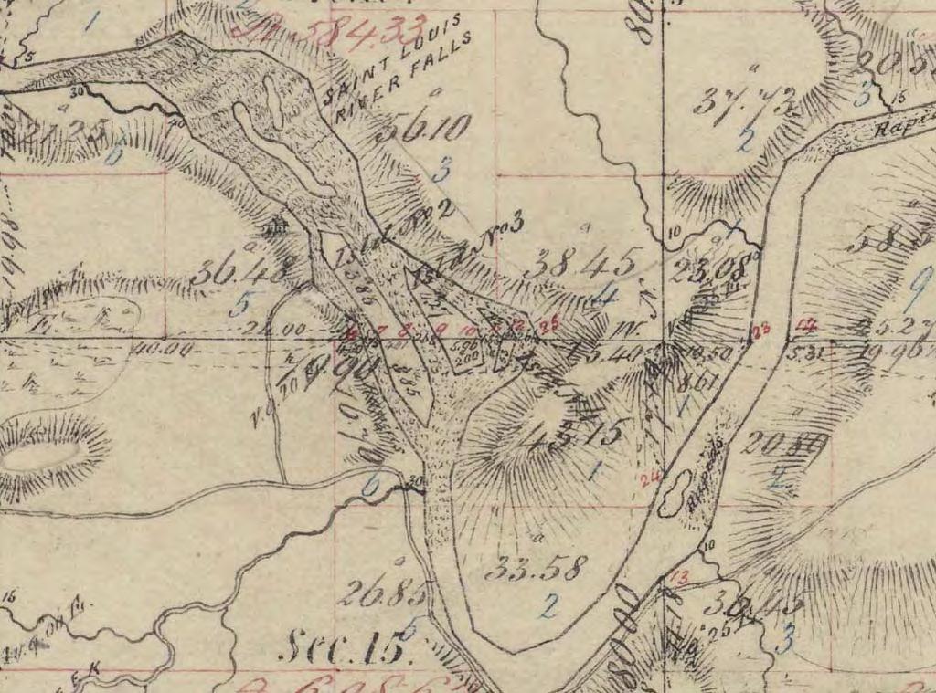
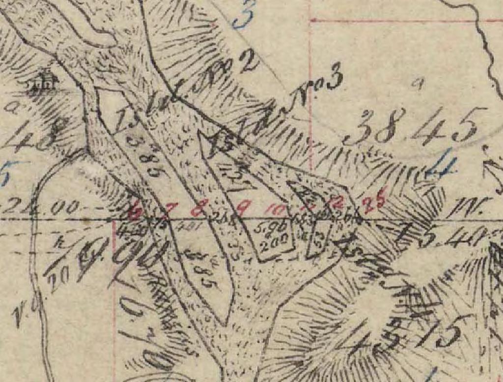
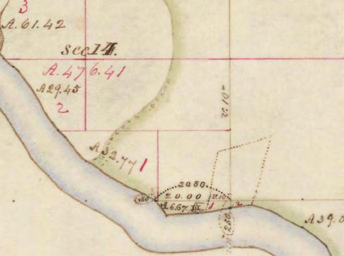
2 Minnesota s Original Public Land Survey Plats (Government Land Office Plats) Used with permission from the Mn Historical Society

3 Minnesota s General Land Office Plats The original public land survey plats were created during the first government land survey of the state. They serve as fundamental legal records for real estate, as an essential resource for surveyors, and as an analytical tool for the state s physical geography prior to European settlement. The original public land survey plats are the official legal land records for Minnesota and all property titles and descriptions stem from them. Used with permission from the Mn Historical Society
4 Deputy Surveyor s Field Notes


5 Plats were drawn by the Surveyor General s office from the field notes
6 This digital collection is a compilation of the state s original plat maps drawn by the U.S. Surveyor General s Office over the years The collection includes later plat maps, up to the year 2001, drawn from surveys conducted by the General Land Office and the Bureau of Land Management. The team : Minnesota Secretary of State Office (SOS) Secretary Mary Kiffmeyer, Bert Black Minnesota Department of Transportation (MnDot) Jay Krafthefer, Dave Gorg (since retired) Minnesota Historical Society (MHS) Bob Horton, Ben Bloom Minnesota Association of County Surveyors (MACS) David Claypool Minnesota Department of Administration Land Management Information Center (LMIC) David Arbeit, John Hoshal

7 Minnesota s Preservation Process Web distribution
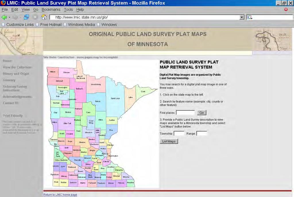
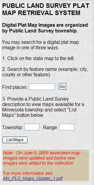
8 Web distribution

9 Web distribution - Township Selection

10 Web Distribution - View or Download
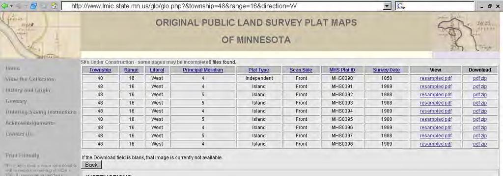
11 Web Distribution - View or Download

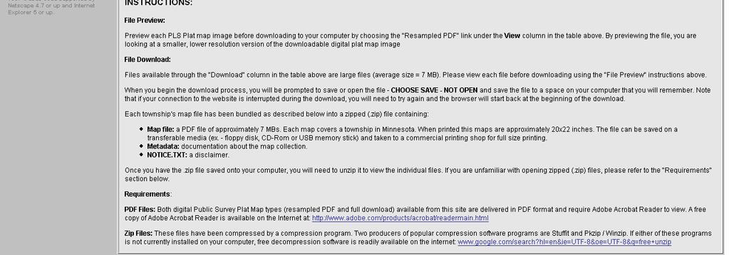
12 View Re-sampled pdf (200 dpi)

13 View Re-sampled pdf (200 dpi)

14 Download pdf (800 dpi)

15 View 200 DPI resampled pdf Download 800 DPI pdf zipped file
16 500% Magnification
17 1140% Magnification
18
19 Why color and high DPI? Comparison GLO: 1867 Minnesota GLO: 1858
20 Final Notes Color verses Black and White Scanning time would be longer File sizes would be larger DPI resolution We wanted the maximum resolution in order to extend the longevity of the images and not have to handle the fragile documents again Ultimate decision: Replicate the plat by using color and high resolution
21 What s Next? The Field Notes Currently doing a pilot project with BLM to scan and index field notes (250,000+pages /750 volumes). It will identify issues and give us an estimate on the cost to complete the entire state. DVD distribution to County Recorders
22 New Plats Platting Law Changes August 1, 2007
23 New Plats Main Changes to MS 505 For the most part, there were not many changes that were not already common practice.
24 New Plats Main Changes to MS Donations, Purpose, Definitions Parks are donated as fee title Subd. 1. Donations. Public ways (street, road, alley, trail, ) are conveyed as easements.
25 New Plats Main Changes to MS Donations, Purpose, Definitions Subd. 2. Purpose. A plat prepared and recorded in accordance with this chapter may be used to: (1) indicate the dedication of easements for public ways, utility easements, and drainage easements as necessary for orderly development; (2) depict one or more parcels for the purpose of simplifying legal descriptions, or; (3) comply with minor subdivision procedures of a local unit of government.
26 New Plats Main Changes to MS Donations, Purpose, Definitions Subd. 3. Definitions. Block Drainage Easement Lot Minor Subdivision procedure Outlot Plat Plat monument Public way Survey line Utility easement Water boundary Wet land Witness monument
27 New Plats Main Changes to MS Plat contents; survey; County Surveyor approval Subd. 1. Plat format. Only one plat size: 22 inches by 34 inches (was 20 x 30 or 30 x 40) Material: 4 mil transparent reproducible film or the equivalent No More Hard Shells!!!!
28 New Plats Main Changes to MS Plat contents; survey; County Surveyor approval Subd. 3. Ownership interest; acknowledgement. The names and signatures of all fee owners, contract for deed vendees, and mortgage holders of record shall appear on the plat, together with a statement as to their interest. Notary stamp not necessary if the jurisdiction, the notary s name, title and expiration date is printed or typed on the plat
29 New Plats Main Changes to MS Plat contents; survey; County Surveyor approval Subd. 5. Mathematical data; dimensions; labels; symbols. The mathematical closure tolerance of the boundary, all lots, blocks, and outlots shall not exceed 0.02 foot Dimension and descriptive recitals in the legal description shall be depicted and labeled on the graphic portion of the plat
30 New Plats Main Changes to MS Plat contents; survey; County Surveyor approval Subd. 10. Survey. Monuments shall be set at all angle and curve points on the outside boundary lines of the plat PRIOR TO RECORDING The surveyor that certifies the plat shall be the surveyor whose license number is on the monuments
31 New Plats Main Changes to MS 505 Subd City, town, and county approval. Plats that subdivide land are subject to the approval of the elected body of the local governmental units exercising their authority over the subdivision of land. Plats that only delineate existing parcels or comply with a minor subdivision procedure may be approved by a local government official designated by the governing body of the local governmental unit exercising authority over the subdivision of land.
32 New Plats Main Changes to MS Subd. 2. Public certified copies. The general public shall have access to and may inspect the plats during normal business hours (instead of at their pleasure ) If a plat or any part thereof becomes illegible from use or wear, it shall be the responsibility of the recorder, registrar, or county surveyor (depending on where the copy resides) to make a reproduction copy of the official plat.the county recorder or registrar certifies it as a correct copy.
33 New Plats Main Changes to MS 505 Repealed Sections: Subd. 1 and Subd. 1, 2a, and Subd. 3 Premature reference to plat; forfeiture Attorneys felt it was not government s place to slow down commerce. By eliminating this subdivision, lawsuits involving penalties and violations would have to be brought under other statutes; and would not be recovered in an action brought in the name of the county unless so specified by statute.
34 Questions?
Plats and subdivisions; mapping requirements. (a) Size Requirements. All land plats presented to the register of deeds for recording in the
 Size Requirements. All land plats presented to the register of deeds for recording in the") 47-30. Plats and subdivisions; mapping requirements. (a) Size Requirements. All land plats presented to the register of deeds for recording in the registry of a county in North Carolina after September
47-30. Plats and subdivisions; mapping requirements. (a) Size Requirements. All land plats presented to the register of deeds for recording in the registry of a county in North Carolina after September
Resolution : A Resolution Recommending Approval Of Preliminary and Final Plats For Emma Krumbees Third Addition
 MEMORANDUM June 11, 2018 TO: FROM: SUBJECT: Planning Chairperson Carter Planning Commission Members Administrator Meyer Cynthia Smith Strack, Community Development Director Resolution 18 013: A Resolution
Map Filing Law. 46: Effective date This act shall take effect January first, one thousand nine hundred and fiftyfour.
 46:23-9.8. Effective date This act shall take effect January first, one thousand nine hundred and fiftyfour. L.1953, c. 358, p. 1941, s. 8. 46:23-9.9. Short title This act shall be known and may be cited
DAWSON COUNTY MINOR PLAT REVIEW CHECKLIST $50.00 FEE PER PLAT REVIEW, $5.00 FEE FOR SCAN & CD FOR RECORDING
 DAWSON COUNTY MINOR PLAT REVIEW CHECKLIST $50.00 FEE PER PLAT REVIEW, $5.00 FEE FOR SCAN & CD FOR RECORDING NAME ON PLAT: CONTACT/PHONE #: NAMED STREET/ADDRESS: LAND LOT: DISTRICT: SECTION: ZONING: SETBACKS:
RULES OF THE GEORGIA STATE BOARD OF REGISTRATION FOR PROFESSIONAL ENGINEERS AND LAND SURVEYORS CHAPTER APPLICATIONS TABLE OF CONTENTS
 RULES OF THE GEORGIA STATE BOARD OF REGISTRATION FOR PROFESSIONAL ENGINEERS AND LAND SURVEYORS CHAPTER 180-7 APPLICATIONS TABLE OF CONTENTS 180-7-.07 Maps and Plats. All maps, plats and similar documents
INSTRUCTIONS FINAL PLAT APPROVAL APPLICATION
 INSTRUCTIONS FINAL PLAT APPROVAL APPLICATION 1. The applicant/agent shall fill out the attached application. The attached application form must be completely filled in before it can be filed. Portions
MINOR SUBDIVISION APPLICATION
 Planning and Development 510 N. Baker St. Mount Dora, FL 32757 352-735-7112 Fax: 352-735-7191 plandev@cityofmountdora.com Date: Project Name: MINOR SUBDIVISION APPLICATION 1. Applicant s Name: 2. Property
STANDARDS GOVERNING CONVEYANCES OF REAL PROPERTY
 STANDARDS GOVERNING CONVEYANCES OF REAL PROPERTY Hancock County, Ohio Charity A. Rauschenberg, Hancock County Auditor Steven C. Wilson, Hancock County Engineer Revised: March 1, 2007 TRANSFER AND CONVEYANCE
FINAL PLAT. Community Development Department 8101 Ralston Road Arvada, Colorado 80002
 FINAL PLAT Community Development Department 8101 Ralston Road Arvada, Colorado 80002 September 2015 FINAL SUBDIVISION PLAT Final Subdivision Plat Review Applications for a Final Plat shall be submitted
MINOR SUBDIVISION PLAT
 MINOR SUBDIVISION PLAT Community Development Department 8101 Ralston Road Arvada, Colorado 80002 MINOR SUBDIVISION PLAT Subdivisions consisting of five (5) or fewer lots are eligible for the minor subdivision
FINAL PLAT GUIDE TO SUBDIVIDING PROPERTY. Background
 FINAL PLAT GUIDE TO SUBDIVIDING PROPERTY Background A final plat is the second step in the process of subdividing land into separate parcels for future sale or lease. Once a preliminary plat has been approved
GENERAL ASSEMBLY OF NORTH CAROLINA SESSION 2017 H 1 HOUSE BILL 454* Short Title: Surveying and Plat Recording Changes. (Public)
") GENERAL ASSEMBLY OF NORTH CAROLINA SESSION H 1 HOUSE BILL * Short Title: Surveying and Plat Recording Changes. (Public) Sponsors: Referred to: Representative Arp. For a complete list of sponsors, refer
GENERAL ASSEMBLY OF NORTH CAROLINA SESSION H 1 HOUSE BILL * Short Title: Surveying and Plat Recording Changes. (Public) Sponsors: Referred to: Representative Arp. For a complete list of sponsors, refer
REQUIREMENTS For Subdivision Plats, Administrative Subdivision Plats, Deposit Surveys and Deeds December 2016
 REQUIREMENTS For Subdivision Plats, Administrative Subdivision Plats, Deposit Surveys and Deeds December 2016 General Requirements - All plats shall have the information necessary to delineate and reestablish
The Hennepin County platting process and common platting problems
 The platting process and common platting problems Tim Eklund Deputy County Surveyor Disclaimer This is a presentation on platting in Your county may be different. Just because we allow something don t
MINOR SUBDIVISION PLAT
 MINOR SUBDIVISION PLAT Community Development Department 8101 Ralston Road Arvada, Colorado 80002 September 2015 MINOR SUBDIVISION PLAT Subdivisions consisting of five (5) or fewer lots are eligible for
MINNESOTA ASSOCIATION OF COUNTYSURVEYORS MANUAL OF MINIMUM GUIDELINES FOR THE PREPARATION OF COUNTY HIGHWAY RIGHT-OF-WAY PLATS
 MINNESOTA ASSOCIATION OF COUNTYSURVEYORS MANUAL OF MINIMUM GUIDELINES FOR THE PREPARATION OF COUNTY HIGHWAY RIGHT-OF-WAY PLATS MARCH,1994 j RECOMMENDED BY: MINNESOTA ASSOCIATION OF COUNTY SURVEYORS MINNESOTA
APPROVAL REQUIREMENTS
 APPROVAL REQUIREMENTS FOR INSTRUMENTS OF CONVEYANCE IN ERIE COUNTY, OHIO DRAFT Requirements for all instruments of Conveyance in Erie County, revised and effective, 2014. An Erie County policy governing
February 20, 2015 COMMON INTEREST COMMUNITY ( CIC ) of minimum guidelines
 of minimum guidelines") February 20, 2015 COMMON INTEREST COMMUNITY PLAT ( CIC ) MANUAL of minimum guidelines TABLE OF CONTENTS PAGE NUMBER INTRODUCTION 1 COMMON INTEREST COMMUNITY PLAT MANUAL APPLICABILITY (515B.1-102) 2-3 I.
February 20, 2015 COMMON INTEREST COMMUNITY PLAT ( CIC ) MANUAL of minimum guidelines TABLE OF CONTENTS PAGE NUMBER INTRODUCTION 1 COMMON INTEREST COMMUNITY PLAT MANUAL APPLICABILITY (515B.1-102) 2-3 I.
Boundary Line Adjustment / Lot Combination General Instructions and Submittal Forms
 CITY OF TENINO PO BOX 4019 149 Hodgden Street South Tenino, WA 98589-4019 Phone (360) 264-2368 FAX (360) 264-5772 Boundary Line Adjustment / Lot Combination General Instructions and Submittal Forms The
City of Fort Lupton Amended Plat Process
 City of Fort Lupton Amended Plat Process Purpose The Amended Plat process is an administrative process to amend a recorded Plat. An Amended Subdivision is an administrative revision to a recorded Subdivision
Ordinance DRAFT An ordinance amending Clallam County Code, Chapter 29.20, Final Plan Requirements and Process, to (fill-in)
") Ordinance DRAFT 07-03 An ordinance amending Clallam County Code, Chapter 29.20, Final Plan Requirements and Process, to (fill-in) BE IT ORDAINED BY THE BOARD OF CLALLAM COUNTY COMMISSIONERS: Section 1.
Ordinance DRAFT 07-03 An ordinance amending Clallam County Code, Chapter 29.20, Final Plan Requirements and Process, to (fill-in) BE IT ORDAINED BY THE BOARD OF CLALLAM COUNTY COMMISSIONERS: Section 1.
Preliminary Plat/Final Plat Application
 Melissa Municipal Center 3411 Barker Avenue Melissa, Texas 75454 Phone: (972) 838-2036 Applicant: Date: Address: Phone: Contact: Fax: E-mail: Propose Addition Name: Acres: Existing Zoning: Propose Zoning:
SUBDIVISION APPLICATION CHECKLIST SKETCH PLAN PRELIMINARY PLAT FINAL PLAT
 RECEIVED STAMP SUBDIVISION APPLICATION CHECKLIST SKETCH PLAN PRELIMINARY PLAT FINAL PLAT A checklist of background information and submission requirements for processing of a sketch plan, preliminary plat
To provide for the review of the final engineering plans, the subdivision improvement agreement, public dedications, and other legal agreements.
 ARTICLE 5 FINAL PLAT 501 Intent DOUGLAS COUNTY SUBDIVISION RESOLUTION To provide for the review of the final engineering plans, the subdivision improvement agreement, public dedications, and other legal
MINOR PLAT FILING APPLICATION
 FILING APPLICATION Date of PC Meeting: Date of BCC Meeting: Fee Paid: 1. APPLICANT: DAYTIME PHONE: MAILING ADDRESS: LANDOWNER: DAYTIME PHONE: MAILING ADDRESS: AUTHORIZED AGENT: MAILING ADDRESS: RELATIONSHIP
SUBMITTAL REQUIREMENTS: The number indicates the number of copies for submittal (if applicable).
.") Office Use Only Preliminary Long Plat Long Subdivision Applicant Checklist PLANNING, COMMUNITY, & ECONOMIC DEVELOPMENT DEPARTMENT FINAL LONG PLAT LONG SUBDIVISION CHECKLIST Mailing Address: P.O. Box 547,
Office Use Only Preliminary Long Plat Long Subdivision Applicant Checklist PLANNING, COMMUNITY, & ECONOMIC DEVELOPMENT DEPARTMENT FINAL LONG PLAT LONG SUBDIVISION CHECKLIST Mailing Address: P.O. Box 547,
Final Plat Approval of a Minor Subdivision Application Packet
 Final Plat Approval of a Minor Subdivision Application Packet 1. Application Packet. Be sure to complete and submit all the required materials that are a part of this Application Packet. Failure to do
1. Name of Property Owner Phone Address. 2. Name of Surveyor. Phone Address. 3. Lots, Block, Section. Subdivision
 MINOR LAND SUBDIVISION PLAN APPLICATION TO COMBINE ADJACENT LOTS WITHIN RECORDED SUBDIVISIONS COOLBAUGH TOWNSHIP 5550 MEMORIAL BOULEVARD TOBYHANNA, PA 18466 570-894-8490 ****************************************************************************************************
APPENDIX C: PLAT SPECIFICATIONS AND CERTIFICATES
 APPENDIX C: PLAT SPECIFICATIONS AND CERTIFICATES A. Drawing. All plats for recording must be submitted on photographically reproducible and dimensionally stable polyester sheets such as Mylar, Cronar or
REQUIREMENTS FOR ALL INSTRUMENTS OF CONVEYANCE IN HARDIN COUNTY, OHIO
 REQUIREMENTS FOR ALL INSTRUMENTS OF CONVEYANCE IN HARDIN COUNTY, OHIO Effective Date: Michael L. Smith, P.E., P.S. Hardin County Engineer Michael T. Bacon Hardin County Auditor 1 I. GENERAL In compliance
APPLICATION FOR MAJOR SUBDIVISION APPROVAL (FINAL PLAT)
") 209 S. Main Street Marysville, Ohio 43040 Phone: (937) 645-7350 Fax: (937) 645-7351 www.marysvilleohio.org APPLICATION FOR MAJOR SUBDIVISION APPROVAL (FINAL PLAT) *** IMPORTANT INFORMATION ~ Please read
209 S. Main Street Marysville, Ohio 43040 Phone: (937) 645-7350 Fax: (937) 645-7351 www.marysvilleohio.org APPLICATION FOR MAJOR SUBDIVISION APPROVAL (FINAL PLAT) *** IMPORTANT INFORMATION ~ Please read
Final Plat Approval of a Major Subdivision Application Packet
 Final Plat Approval of a Major Subdivision Application Packet 1. Application Packet. Be sure to complete and submit all the required materials that are a part of this Application Packet. Failure to do
Change In The Name Of Owner (s) Of Land.
 Of Land.") Clermont County TRANSFER AND CONVEYANCE STANDARDS OF THE CLERMONT COUNTY AUDITOR AND THE CLERMONT COUNTY ENGINEER AS ADOPTED UNDER OHIO REVISED CODE SECTION 319.203, AS A RESULT OF TWO PUBLIC HEARINGS
Clermont County TRANSFER AND CONVEYANCE STANDARDS OF THE CLERMONT COUNTY AUDITOR AND THE CLERMONT COUNTY ENGINEER AS ADOPTED UNDER OHIO REVISED CODE SECTION 319.203, AS A RESULT OF TWO PUBLIC HEARINGS
Final Plat Mapping Requirements
 CURRENT PLANNING DIVISION 410 E. 5 th Street Loveland, CO 80537 970-962-2523 eplan-planning@cityofloveland.org cityofloveland.org/dc Final Plat Mapping Requirements All Final plats shall comply with the
CITY OF TONKA BAY HENNEPIN COUNTY, MINNESOTA DEVELOPMENT AGREEMENT REGARDING THE SUNRISE ADDITION SUBDIVISION
 CITY OF TONKA BAY HENNEPIN COUNTY, MINNESOTA DEVELOPMENT AGREEMENT REGARDING THE SUNRISE ADDITION SUBDIVISION THIS DEVELOPMENT AGREEMENT ( Agreement ) is made and entered into this day of, 2016, by and
PARCEL MERGER APPLICATION
 CITY OF WILDOMAR Planning Department 23873 Clinton Keith Road, Suite #201 Wildomar, CA 92595 Tel. (951) 677-7751 Fax. (951) 698-1463 For office use only. Project Deposit Account Number PROJECT INFORMATION
PRELIMINARY PLAT CHECK LIST
 PRELIMINARY PLAT CHECK LIST Name of Proposed Subdivision: The following items must be included with the initial submittal of a Preliminary Plat: Application, filled out completely Project Narrative Pre-application
MINOR PLAT AMENDMENT APPLICATION CHECK APPLICABLE PERMIT ATTACHMENT:
 240 East Gammon Road Vineyard, Utah 84058 (801) 226-1929 MINOR PLAT AMMENDMENT APPLICATION Please Note: Attachment of request specific documents is required prior to processing your application. APPLICATION
TRANSFER AND CONVEYANCE STANDARDS OF THE PICKAWAY COUNTY AUDITOR AND THE PICKAWAY COUNTY ENGINEER
 TRANSFER AND CONVEYANCE STANDARDS OF THE PICKAWAY COUNTY AUDITOR AND THE PICKAWAY COUNTY ENGINEER Melissa A. Betz, Auditor Robert E. Parker, P.E., P.S., Engineer AS ADOPTED UNDER OHIO REVISED CODE SECTION
APPLICATION FOR FINAL PLAT APPROVAL (Major Subdivision)
") APPLICATION FOR FINAL PLAT APPROVAL (Major Subdivision) CITY OF HOSCHTON, GA PLANNING AND DEVELOPMENT 79 City Square Hoschton, GA 30548 706-654-3034 Applicant Information: Name: Address: City, State, Zip:
APPLICATION FOR FINAL PLAT APPROVAL (Major Subdivision) CITY OF HOSCHTON, GA PLANNING AND DEVELOPMENT 79 City Square Hoschton, GA 30548 706-654-3034 Applicant Information: Name: Address: City, State, Zip:
WYANDOT COUNTY BASIC STANDARDS FOR THE APPROVAL OF REAL ESTATE DEED TRANSFERS & LAND CONTRACT AGREEMENTS
 GENERAL In compliance with Section 315.251 of the Ohio Revised Code, the County Auditor and the County Engineer have adopted these written standards governing the conveyance of real property in Wyandot
ARTICLE III GENERAL PROCEDURES, MINOR PLANS AND FEE SCHEDULES
 ARTICLE III GENERAL PROCEDURES, MINOR PLANS AND FEE SCHEDULES 301. Prior to Submission a. Copies of this Ordinance shall be available on request, at cost, for the use of any person who desires information
CHAPTER FINAL AND PARCEL MAPS
 CHAPTER 19.48 FINAL AND PARCEL MAPS Section Page 19.48.010 General... IV-25 19.48.020 Phasing... IV-25 19.48.030 Survey Required... IV-26 19.49.040 Form... IV-26 19.48.050 Contents... IV-27 19.48.060 Preliminary
MINOR SUBDIVISION PLAT CHECKLIST
 MINOR SUBDIVISION PLAT CHECKLIST Project Name: Tax ID #: Project Number: Date: _ Reviewed By: Telephone: NOTES: All lots on septic systems must comply with the Fulton County Health Department requirements
MASTER SUBDIVISION FINAL PLAT APPLICATION Town of Apex, North Carolina
 MASTER SUBDIVISION FINAL PLAT APPLICATION Town of Apex, North Carolina This document is a public record under the North Carolina Public Records Act and may be published to the Town s website or disclosed
Standards of Practice for Surveying in the State of Alabama
 Standards of Practice for Surveying in the State of Alabama Effective January 1, 2017 RULE NO. 1.01 PURPOSE The purpose of these rules is to establish standards for the practice of surveying in the State
SUBDIVISION APPLICATION
 STAFF USE ONLY Date Submitted: Received by: Fee paid: Project # REQUIRED SUBMITTALS Application Fee: $600.00 (up to 5 lots) + $50.00 (per lot above 5) Publication Fee: $300.00 Mailing Fee: $6.00 per hearing
APPLICATION FOR MAJOR SUBDIVISION APPROVAL (PRELIMINARY PLAT)
") 209 S. Main Street Marysville, Ohio 43040 Phone: (937) 645-7350 Fax: (937) 645-7351 www.marysvilleohio.org APPLICATION FOR MAJOR SUBDIVISION APPROVAL (PRELIMINARY PLAT) *** IMPORTANT INFORMATION ~ Please
209 S. Main Street Marysville, Ohio 43040 Phone: (937) 645-7350 Fax: (937) 645-7351 www.marysvilleohio.org APPLICATION FOR MAJOR SUBDIVISION APPROVAL (PRELIMINARY PLAT) *** IMPORTANT INFORMATION ~ Please
Standards for All Instruments of Conveyance
 Standards for All Instruments of Conveyance Perry County, Ohio Effective Date: May 1, 1997 Effective Date of Revision: April 1, 2011 Page 2 of 12 Minimum Standards for all Instruments of Conveyance Perry
ALEXANDRIA TOWNSHIP METES & BOUNDS SUBDIVISION APPLICATION. Name of Applicant Phone. Property Address (E911#) Mailing Address Local Phone
 Mailing Address Local Phone") Application # Date Application Rec d / / (for office use only) Fee Collected $ ALEXANDRIA TOWNSHIP METES & BOUNDS SUBDIVISION APPLICATION Name of Applicant Phone Property Address (E911#) Mailing Address
Application # Date Application Rec d / / (for office use only) Fee Collected $ ALEXANDRIA TOWNSHIP METES & BOUNDS SUBDIVISION APPLICATION Name of Applicant Phone Property Address (E911#) Mailing Address
OTTAWA COUNTY LEGAL DESCRIPTION REVIEW GUIDELINES
 OTTAWA COUNTY LEGAL DESCRIPTION REVIEW GUIDELINES APPROVED BY: RONALD P. LAJTI, JR., P.E., P.S. OTTAWA COUNTY ENGINEER APPROVED BY: LAWRENCE HARTLAUB OTTAWA COUNTY AUDITOR EFFECTIVE DATE: January 1, 2017
APPENDIX C: FINAL PLAT REVIEW CHECKLIST
 FINAL PLAT REVIEW CHECKLIST The Office of Permitting Services processes final record plats though the City agencies for review and approval and ultimate recording of the final plat at the Orange County
I. Requirements for All Applications. C D W
 108-16.1. Application checklists. Checklist for Required Submissions to the Planning Board or Zoning Board of Adjustment of Monroe Township All required submissions are to be made to the Administrative
Department of Development Services Engineering; Survey Plat Review Group SPRG
 Department of Development Services Engineering; Survey Plat Review Group SPRG CITY OF DALLAS LEGAL DESCRIPTION PREPARATION GUIDELINE AND CHECKLIST The following guideline and checklist are provided to
Requirements for All Instruments of Conveyance in Logan County, Ohio
 Requirements for All Instruments of Conveyance in Logan County, Ohio Effective Date: April 11, 1997 It is the intent of these requirements to provide a standard method of checking legal descriptions for
SUBDIVISION APPLICATION INSTRUCTIONS
 SUBDIVISION APPLICATION INSTRUCTIONS APPLICATION FORM The application form must be fully completed, signed by the property owner and shall be properly notarized. AGENT AUTHORIZATION FORM If the applicant
SECTION 10 STANDARD PLATS
 SECTION 10 - STANDARD PLATS Subdivision 1: Purpose Standard Plats allow the subdivision of land into lots smaller than the minimum metes and bounds size in the zoning district, and control road development
PRELMINARY PLAT CHECKLIST
 PRELMINARY PLAT CHECKLIST A. All preliminary plat submitted for approval shall be prepared by a Registered Professional Land Surveyor. B. Preliminary plats must be drawn to a scale of XXX with such accuracy
SUBDIVISION APPLICATION
 SUBDIVISION APPLICATION Preliminary Plat Minor Plat Final Plat Amended Plat Applicant Name: Owner (if different from applicant) Name: Company: Company: Address: Address: City, State, Zip City, State, Zip
Administrative Plat Submittal Checklist (Minor, Development)
") Planning & Community Development Department 550 Landa Street New Braunfels, Texas 78130 (830) 221-4050 www.nbtexas.org CC/Cash/Check No.: Amount Recd. $ Receipt No.: Case No.: Submittal date office use
Planning & Community Development Department 550 Landa Street New Braunfels, Texas 78130 (830) 221-4050 www.nbtexas.org CC/Cash/Check No.: Amount Recd. $ Receipt No.: Case No.: Submittal date office use
Beltrami County Natural Resource Management Policy: Easements and Access Across County Lands
 Page 1 Purpose Beltrami County Natural Resource Management Policy: Easements and Access Across County Lands The procedure and requirements for private, government, commercial, and utility entities to cross
1. NAME OF SUBDIVISION : DATE SUBMITTED: LOCATION OF SUBDIVISION : DATE OF PRELIMINARY APPROVAL BY TOWNSHIP SUPERVISORS:
 1 RICHLAND TOWNSHIP PLANNING COMMISSION 322 SCHOOLHOUSE ROAD, SUITE 110 JOHNSTOWN, PA 15904 FINAL SUBDIVISION APPLICATION LAND DEVELOPMENT OR LAND MERGER OR MINOR SUBDIVISION THE UNDERSIGNED HEREBY APPLIES
Delaware County Transfer Standards
 Delaware County Transfer Standards Delaware County Auditor David A. Yost Delaware County Engineer Chris Bauserman Adopted in 1997, Amended in 1999 Dave Yost County Auditor Chris Bauserman County Engineer
PETITION FOR VOLUNTARY ANNEXATION Town of Apex, North Carolina
 Town of Apex, North Carolina ANNEXATION PETITION SUBMISSION: Applications are due by 12:00 pm on the first business day of each month. See the Annexation Petition Schedule on the website for details. ANNEXATION
SHORT PLAT Information
 Information This form provides information and an explanation of the procedures of a Short Plat. If you have any questions, contact the Planning and Development Services Department at (253) 566-5656. A
MINOR SUBDIVISION FINAL PLAT APPLICATION Town of Apex, North Carolina
 MINOR SUBDIVISION FINAL PLAT APPLICATION Town of Apex, North Carolina This document is a public record under the North Carolina Public Records Act and may be published on the Town s website or disclosed
MINOR PLAT. The following documents are provided as required by the City of Conroe for use in the above titled platting submittals:
 Public Works - Engineering Division CITY OF CONROE MINOR PLAT The following documents are provided as required by the City of Conroe for use in the above titled platting submittals: Submittal Questionnaire
COUNTY OF ALBEMARLE APPLICATION FOR FAMILY DIVISION. Family Division = $742 (Provide 5 copies of plat)
") Page 1 APPLICATION FOR FAMILY DIVISION Family Division = $742 (Provide 5 copies of plat) Tier 2 Groundwater Review = $355 (Required for all plats showing lots less than 21 acres) Tier 3 Groundwater Review
Page 1 APPLICATION FOR FAMILY DIVISION Family Division = $742 (Provide 5 copies of plat) Tier 2 Groundwater Review = $355 (Required for all plats showing lots less than 21 acres) Tier 3 Groundwater Review
Final Subdivision Plat
 Final Subdivision Plat Application Packet Public Works Department New Development Division 175 East 200 North St. George, UT 84770 Office (435) 627-4120 Dear Applicant, This packet has been prepared to
PETITION APPLICATION PROCEDURE
 INSTRUCTIONS & EXPLANATIONS TO ABANDON/VACATE RIGHTS OF WAY, EASEMENTS AND PLATS UNDER THE JURISDICTION OF THE BOARD OF COUNTY COMMISSIONERS OF PALM BEACH COUNTY The following are explanations of the required
CHAPTER SHORT SUBDIVISIONS
 CITY OF MOSES LAKE MUNICIPAL CODE CHAPTER 17.09 SHORT SUBDIVISIONS Sections: 17.09.010 Purpose 17.09.020 Scope 17.09.030 Preliminary Short Subdivision Conditions and Requirements 17.09.040 Referral to
Conveyance Standards. Boundary Survey Requirements. Adams County, Ohio
 Conveyance Standards And Boundary Survey Requirements Adams County, Ohio OFFICE OF THE ADAMS COUNTY AUDITOR DAVID GIFFORD 110 WEST MAIN STREET WEST UNION, OH 45693 OFFICE OF THE ADAMS COUNTY ENGINEER DAVID
Guide to Combined Preliminary and Final Plats
 Guide to Combined Preliminary and Final Plats Introduction The Douglas County is committed to providing open, transparent application processes to the public. This Guide is provided to assist anyone interested
City of Yelm. Community Development Department BOUNDARY LINE ADJUSTMENT OR LARGE LOT SUBDIVISION
 City of Yelm Community Development Department BOUNDARY LINE ADJUSTMENT OR LARGE LOT SUBDIVISION Fee Date Received By File No. FEES: Boundary Line Adjustment $100.00 LARGE LOT SUBDIVISION $250.00, + $10.00/lot
ARTICLE 1 GENERAL PROVISIONS
 ARTICLE 1 GENERAL PROVISIONS SECTION 100 TITLE This Ordinance shall be known and cited as the "Rice Township Subdivision and Land Development Ordinance." SECTION 101 AUTHORITY Rice Township is empowered
APP. FEE: $ DATE & TIME LOCATION: 1/4 SECTION SECTION TOWNSHIP RANGE STREET ADDRESS AND GENERAL LOCATION OF PROPERTY CITY, STATE PHONE (DAY):
:") REVERSION TO ACREAGE PURSUANT TO N.R.S. 278.490 through 478.4965 Elko County Planning & Zoning 155 South 9th Street, Elko, NV 89801 (775) 738-6816 or 738-2266 APPLICATION MUST BE SUBMITTED WITH ALL REQUIRED
REVERSION TO ACREAGE PURSUANT TO N.R.S. 278.490 through 478.4965 Elko County Planning & Zoning 155 South 9th Street, Elko, NV 89801 (775) 738-6816 or 738-2266 APPLICATION MUST BE SUBMITTED WITH ALL REQUIRED
NOT TO BE SUBMITTED WITH SKETCH DESIGN APPROVAL Subdivision Checklist: Major Subdivision Final Plat
 Must be received with review fee (equal to $200.00, plus $25.00 per lot) no later than 15 days prior to Planning Board meeting, which is normally the first Monday of the month (certain holidays may modify
SUBDIVISION APPLICATION: RECOMBINATION PLAT or EXEMPT PLAT
 SUBDIVISION APPLICATION: RECOMBINATION PLAT or EXEMPT PLAT Pursuant to Article 7, Section 155.706 of the Unified Development Code, an owner of land within the jurisdiction of the Town (or a duly authorized
APPLICATION for MINOR SUBDIVISION REVIEW for CONCEPT and FINAL PLAT within COALVILLE CITY. Project Name: Project Address or Area: Name of Owner:
 APPLICATION for MINOR SUBDIVISION REVIEW for CONCEPT and FINAL PLAT within COALVILLE CITY For Office Use Only: Application #: Application Date: PC Approval Date: CC Approval Date: Community Development
(effective Jan. 1, 2017) Recordation of maps and plats; specifications (Georgia Plat Act)
 Recordation of maps and plats; specifications (Georgia Plat Act)") 15-6-67. (effective Jan. 1, 2017) Recordation of maps and plats; specifications (Georgia Plat Act) (a) The clerk of superior court shall file and record maps, plats, and subdivision plats, and condominium
15-6-67. (effective Jan. 1, 2017) Recordation of maps and plats; specifications (Georgia Plat Act) (a) The clerk of superior court shall file and record maps, plats, and subdivision plats, and condominium
CITY OF VICTORIA Location Map
 CITY OF VICTORIA Location Map Map Date: 2/8/2019 ± 0 0.05 0.1 0.2 0.3 0.4 mi Hawks Pointe City of Victoria, Carver County GIS CITY OF VICTORIA COUNTY OF CARVER STATE OF MINNESOTA ORDINANCE NO. XX AN
FINAL MAP PLAN CHECK
 Engineering Division 201 North Broadway, Escondido, CA 92025 (760) 839-4651, FAX (760) 839-4597 FINAL MAP PLAN CHECK To: Date: Project: Address: Check No: Attn: VIA: The attached FINAL MAP has been reviewed
Ballard City Final Plat Check List
 Ballard City Final Plat Check List TO BE COMPLETED BY BOTH THE DEVELOPER AND THE CITY Design: Check: Check each of the following items for compliance with adopted City Standards, Titles, General Plans
TRANSFER PROCEDURES FOR WASHINGTON COUNTY, OHIO
 TRANSFER PROCEDURES FOR WASHINGTON COUNTY, OHIO The following requirements are adopted and established in conjunction with the Washington County Engineer and the Washington County Auditor as prescribed
A lot line or terminology adjustment will be reviewed concurrently with any other development review application(s) that are required.
 that are required.") RELATED FACTS TO KNOW: Adams County Recording Requirements, Annexation, Common Wall Subdivision, Development Plan (PUD Development Permit), Fees, Helpful Contact Information, Neighborhood Meeting, Park
RELATED FACTS TO KNOW: Adams County Recording Requirements, Annexation, Common Wall Subdivision, Development Plan (PUD Development Permit), Fees, Helpful Contact Information, Neighborhood Meeting, Park
LAND CONVEYANCE STANDARDS AND REQUIREMENTS FOR APPROVALS OF DEED DESCRIPTIONS, SURVEYS AND PLATS IN MEDINA COUNTY, OHIO
 LAND CONVEYANCE STANDARDS AND REQUIREMENTS FOR APPROVALS OF DEED DESCRIPTIONS, SURVEYS AND PLATS IN MEDINA COUNTY, OHIO PREPARED BY THE OFFICE OF THE MEDINA COUNTY AUDITOR AND THE OFFICE OF THE MEDINA
Auditor's Office Tuscarawas County
 Auditor's Office Tuscarawas County MATT JUDY, Auditor Telephone 125 E. High Avenue (330) 365-3220 New Philadelphia, Ohio 44663 Fax: (330) 365-3397 TO: FROM: Title Companies, Surveyors, Attorneys & Financial
A Final Plat will be reviewed concurrently with any other development review application(s) that is required.
 that is required.") RELATED FACTS TO KNOW: Adams County Recording Requirements, Annexation, Common Wall Subdivision, Development Plan (PUD Development Permit), Fees, Helpful Contact Information, Lot Line Adjustment, Neighborhood
RELATED FACTS TO KNOW: Adams County Recording Requirements, Annexation, Common Wall Subdivision, Development Plan (PUD Development Permit), Fees, Helpful Contact Information, Lot Line Adjustment, Neighborhood
MnDOT Contract No Exhibit B. Scope of Work. Scope of Work
 MnDOT Contract No. 1032993 Contract General Description The purpose of this contract is to provide the State with the survey accurate re-establishment of designated Public Land Survey section boundaries
17 HB 76/AP A BILL TO BE ENTITLED AN ACT BE IT ENACTED BY THE GENERAL ASSEMBLY OF GEORGIA:
 House Bill 76 (AS PASSED HOUSE AND SENATE) By: Representatives Jasperse of the 11 th and Petrea of the 166 th A BILL TO BE ENTITLED AN ACT 1 2 3 4 5 6 To amend Title 15 of the Official Code of Georgia
CHAPTER 9.06 BOUNDARY LINE ADJUSTMENTS
 CHAPTER 9.06 BOUNDARY LINE ADJUSTMENTS SECTIONS: 9.06.010 Purpose 9.06.020 Applicability 9.06.030 Application 9.06.040 Plan For Boundary Line Adjustment 9.06.050 Criteria For Approval 9.06.060 Approval
Chapter 14 Administration
 Chapter 14 Administration Land Development Code Driggs, Idaho June 2017 Chapter 14 - Administration Art. 1.1. Contents Art. 14.1. Summary of Review Authority 14-3 Art. 14.2. General Provisions 14-4 14.2.1.
SHERBURNE COUNTY PUBLIC WORKS PLATTING MANUAL **(Revised 12/2017)**
**") SHERBURNE COUNTY PUBLIC WORKS PLATTING MANUAL **(Revised 12/2017)** PUBLIC WORKS CONTACTS Public Works Department Government Center 13880 Business Center Dr. Suite 100 Phone: 763-765-3300 800-594-5208
SHERBURNE COUNTY PUBLIC WORKS PLATTING MANUAL **(Revised 12/2017)** PUBLIC WORKS CONTACTS Public Works Department Government Center 13880 Business Center Dr. Suite 100 Phone: 763-765-3300 800-594-5208
SUBDIVISION APPLICATION
 SUBDIVISION APPLICATION City of Horn Lake Planning Department 3101 Goodman Road, W Horn Lake, MS 38637 662-342-3559 Fax: 662-342-3485 Applications due the 1st working day of the month. Submit application
Preliminary Replat. Application No. List of Required Submittals Only complete applications will be accepted:
 Preliminary Replat Application No. List of Required Submittals Only complete applications will be accepted: Included in this packet: Pre-Application Meeting Notes Application Affidavit to Authorize Agent
Division of Land Application
 FOR PLANNING USE ONLY Application # DIV Application Fee Receipt No. Filing Date Completeness Date Division of Land Application A. PROJECT INFORMATION 1. Project Name: 2. Address of Subject Property: 3.
Minor Subdivision Application
 FOR PLANNING USE ONLY Application # SD Application Fee $1,000.00 Receipt No. Filing Date Completeness Date Minor Subdivision Application A. PROJECT INFORMATION 1. Project Name: 2. Address of Subject Property:
250 CMR: BOARD OF REGISTRATION OF PROFESSIONAL ENGINEERS AND LAND SURVEYORS DRAFT FOR DISCUSSION PURPOSES ONLY
 250 CMR 6.00: LAND SURVEYING PROCEDURES AND STANDARDS Section 6.01: Elements Common to All Survey Works 6.02: Survey Works of Lines Affecting Property Rights All land surveying work is considered work
2018 EASEMENT DEDICATION PACKET
 2018 EASEMENT DEDICATION PACKET (INCLUDES PARCELS OF LAND, EASEMENTS, AND RIGHTS-OF-WAY FOR PUBLIC USE) Information Packet There are various situations in which easements, rights-of-way, and parcels of
The Filing Fee for a Minor Plat is $ PLUS $20.00 per lot created
 DEPARTMENT OF COMMUNITY DEVELOPMENT MINOR PLAT PROCEDURE The Filing Fee for a Minor Plat is $250.00 PLUS $20.00 per lot created Description: The purpose of a Minor Plat is to allow property to be platted