ORDINANCE # ** LAND USE ORDINANCE FOR CASS COUNTY, MINNESOTA
|
|
|
- Lester Dennis
- 6 years ago
- Views:
Transcription
1 ORDINANCE # ** LAND USE ORDINANCE FOR CASS COUNTY, MINNESOTA **--Incorporating Amendments made by: Ordinance # EFFECTIVE DATE: September 5, 2005 Ordinance # EFFECTIVE DATE: November 14, 2005 Ordinance # EFFECTIVE DATE: July 15, 2008 Ordinance # Effective Date: March 1, 2009 Ordinance # Effective Date: January 1, 2010 Ordinance # Effective Date: December 31, 2009 Ordinance # Effective Date: January 10, 2010 Ordinance # Effective Date: February 15, 2013 Ordinance # Effective Date: September 22, 2014 Ordinance #2016-XX Effective Date:
2 Table of Contents 100 TITLE PURPOSE, AUTHORITY, AND JURISDICTION PURPOSE AUTHORITY REPEALOR JURISDICTION COUNTY COMPREHENSIVE PLAN GENERAL APPLICATION OF THIS ORDINANCE Interpretation Conflicting Regulations Severability Abrogation and Greater Restrictions RULES OF CONSTRUCTION SSTS UPGRADE ON CONVEYANCE OF PROPERTY VESTED RIGHTS DEFINITIONS ADMINISTRATION PERMITS REQUIRED Responsibility to Obtain Other Permits Payment and Delinquent Taxes and Fees EXISTING VIOLATIONS FINANCIAL ASSURANCE NOTIFICATION TO THE MN DNR Notices of Public Hearing Notices of Approval FEES Schedule Payment Refunds ENFORCEMENT PROSECUTION DUTY TO ENFORCE CEASE AND DESIST ORDERS ADMINISTRATIVE FEES AND RESTORATION PLANNING COMMISSION (PC) AUTHORITY MEMBERSHIP TERMS OF OFFICE DUTIES AND RESPONSIBILITIES CONDITIONAL USE PERMITS (CUP) Purpose and Process Conditional Use Review Conditions Attached Lapse of Conditional Use LAND USE RECLASSIFICATION PROCEDURES Land Use Reclassification Request Reclassification Criteria Initiation of Request Notice of Hearing Re-submission of Previously Denied Petitions ORDINANCE AMENDMENT PROCEDURES
3 800 VARIANCES AND APPEALS VARIANCES Applications and Notices Variance Criteria Findings and Fact Conditions Lapse of Variance APPEALS Appeals of Variances Appeals of Administrative Decisions RECORDS LAND USE DISTRICTS AND MAP ESTABLISHMENT OF LAND USE DISTRICTS CONSISTENT WITH COMPREHENSIVE PLAN LAND USE DISTRICT DESCRIPTIONS Shoreland Municipal Growth (MG) Rural Residential-1 (RR-1) Rural Residential-2.5 (RR-2.5) Rural Residential-5, 10, and 20 (RR-5, RR-10, RR-20) Agricultural/Forestry (AF) Commercial (C-1) Commercial (C-2) Water Oriented Commercial - (WOC) Resource Protection - (RP) LAND USE DISTRICTS MAP INTERPRETATION OF MAPS DISTRICT LAND USE REGULATIONS USES PERFORMANCE STANDARDS ACCESSORY STRUCTURES RESIDENTIAL AGRICULTURAL USES Agricultural Easements Feedlots Animal Density Regulations AIRPORTS, HELIPORTS, AND LANDING STRIPS COMMERCIAL USE Convenience Stores Retail - Service Kennels - Commercial Motor Vehicle Service Stations and Equipment Repair Outdoor Entertainment Outdoor Recreation Facilities Outdoor Storage Water Oriented Restaurants Marinas RESORTS COUNTY-ADMINISTERED LANDS PRIVATE USE EARTHMOVING Non-Shoreland zone standards Shoreland Zone Standards Specific Standards Shoreland Alterations Harbor Excavation Public and Private Roads, Parking Areas Conditions
4 1107 EXTRACTIVE USE Permitting of Existing Commercial Extractive Uses Application Requirements New Extractive Uses Review Criteria Extractive Use Easements Extractive Use in Conjunction with County and Township Road Projects FOREST MANAGEMENT HANDICAP ACCESSIBILITY STANDARDS HOME BUSINESS HOME OCCUPATION SUBSURFACE SEWAGE TREATMENT SYSTEMS LOT STANDARDS Lot Area, Lot Width, Buildable Area Standards for Lake and River Classification Lot Standards for Non Shoreland Classifications Impervious Surface Coverage Water Access Lots and Access Easements MANUFACTURED HOUSING PARKS Permitting Permitted Uses Design Standards, Numbers of Lots, and Improvements NON CONFORMING USES AND LOTS Non Conforming Uses Construction on Non Conforming Lots Non-Conforming Structures DEVELOPMENT STANDARDS Purpose and Applicability Development Application Process Environmental Review Criteria for Evaluation Design Changes Maintenance and Administration Requirements Conservation Development Standards Conservation Development Design Process, Criteria, and Density Evaluation Conservation Development Density Evaluation Centralization and Design of Facilities Conventional Development Standards Conventional Development Design Process and Criteria Conventional Development Density Evaluation Shoreland and Non-Shoreland Areas Conventional Development Open Space Requirements Erosion Control, Storm Water Management, and Sediment Control PUBLIC NUISANCES Purpose and Standards Abatement of Public Nuisances RECREATIONAL CAMPING AREAS AND RECREATIONAL CAMPING VEHICLE PARK CAMPGROUNDS Permit Density RENEWABLE ENERGY SYSTEMS AND FACILITIES Wind Energy Systems Additional Standards RESIDENTIAL LOTS, SINGLE FAMILY RESIDENTIAL LOTS, MULTIPLE FAMILY, PRIVATE CAMPGROUNDS SALVAGE YARDS Salvage Yards Standards SHORELAND BUFFER STANDARDS SIGNS Purpose General Provisions Prohibited Characteristics Sign Classifications Performance Standards
5 Non Conforming Signs STORMWATER MANAGEMENT General Standards Specific Standards STRUCTURES--PLACEMENT, DESIGN, AND HEIGHT Structure Setbacks Height of Structures Flood Prevention Water Oriented Accessory Structures or Facilities Guest Quarter Standards Stairways, Lifts, and Landings Platform/Patio Decks Retaining Walls Fences Docks Boardwalks and Walkways Watercraft Access Ramps Swimming Pools TELECOMMUNICATION TOWERS Purpose Permits Tower and Antenna Design Requirements Tower Setbacks Co Location Requirements Antenna Mounted on Existing Buildings or Towers Accessory Utility Buildings Tower Lighting Abandoned or Unused Towers Public Safety Telecommunications Interference Non Conforming Towers VEGETATIVE ALTERATIONS Bluff Impact Zones / Steep Slopes Shore Impact Zone Shore Impact Zone Conditions WATER ORIENTED COMMERCIAL USES WATER WELLS WILDLIFE PONDS SHORELAND CLASSIFICATION SHORELAND CLASSIFICATION SYSTEM AMENDMENTS TO LAKE OR STREAM CLASSIFICATION & DESIGNATION OF RESOURCE PROTECTION DISTRICTS Amendments to Lakes or Streams Designation of Resource Protection Districts and Reclassification of Bays of Lakes ADOPTION APPENDIX A-- CASS COUNTY ROAD SPECIFICATIONS DESIGN CRITERIA REQUIRED CLASS 5 AGGREGATE ADDITION BY SUBGRADE SOIL TYPE TYPICAL CARTWAY AND LOCAL ROAD CROSS SECTIONS ADDITIONAL SPECIFICATIONS APPENDIX B-1 AGRICULTURAL MANAGEMENT EASEMENTS APPENDIX B-2 EXTRACTIVE USE EASEMENT APPENDIX C LOT WIDTH, BLUFF, AND HEIGHT OF STRUCTURE EXAMPLES APPENDIX D - SHORELINE RAPID ASSESSMENT MODEL 5 Formatted: Normal Formatted: Font: (Default) Arial, Check spelling and grammar
6 APPENDIX D E LIST OF ABBREVIATIONS AND ACRONYMS Formatted: Strikethrough 6
7 100 TITLE This ordinance shall be known as the LAND USE ORDINANCE FOR CASS COUNTY, MINNESOTA, hereinafter referred to as the ordinance. 200 PURPOSE, AUTHORITY, AND JURISDICTION 201 PURPOSE This ordinance is intended to protect, preserve, and enhance the quality of the lakes, rivers, forests, wetlands, natural land forms, and open spaces of Cass County for future generations. Further, it is the goal of this ordinance to promote the health, safety, general welfare, and orderly development of Cass County by: A.Regulating land use in accordance with the County Comprehensive Plan. B.Promoting orderly development of the residential, business, industrial, recreational and public areas of Cass County. C.Dividing the County into zones. D.Regulating the location, height, and bulk of structures. E.Regulating setbacks. F.Regulating sizes of lots, yards, and other open spaces. G.Preventing overcrowding of land and undue concentration of structures. H.Encouraging compatible developments of different land use and the most appropriate use of land within the County. I.Maintaining and enhancing the quality and condition of natural resources within the County. J.Providing adequate access to air, direct sunlight, and convenience of access to property. K.Bringing all non-complying subsurface sewage treatment systems into compliance. This ordinance is also intended to protect the shoreland of public waters and the Mississippi River and Headwaters Lakes it flows through, and thus preserve and enhance the quality of surface waters, conserve the economic and natural environmental values of shoreland, and provide for the wise use and protection of waters and related land resources. 7
8 202 AUTHORITY This ordinance establishes land use regulations pursuant to Minnesota Statutes, Chapter 394, and the Cass County Comprehensive Land Use Plan. The shoreland section herein is adopted pursuant to Minnesota Statutes, Chapter 103F.201 to 103F.221, and Minnesota Rules, Chapter Regulation of campgrounds, recreational vehicle parks and manufactured housing parks are pursuant to Minnesota Statutes, Chapters ; 394; to ; and 145A.01 to 145A.07. The following ordinances and references are hereby incorporated herein by reference: the Subdivision and Platting Ordinance for Cass County, Minnesota; the Cass County Subsurface Sewage Treatment System Ordinance, the Mississippi Headwaters Management Plan, the Cass County Solid Waste Ordinance, and the Zoning Dictionary, 1999 edition (Lehman & Associates). A.Shoreland. Shoreland regulations apply to that area within 1,320 (thirteen-hundred twenty) feet of the Ordinary High Water Mark (OHWM) of all public waters included in Appendix D and are adopted pursuant to Minnesota Statutes chapter 103F.201 to 103F.221 and Minnesota Rules B.Campgrounds, Recreational Vehicle Parks and Manufactured Housing Parks. Adopted pursuant to Minnesota Statutes Chapter 145A.01 to 145A.07, to , , and 394. C.Airport Safety Zone. The Commissioner of MN DOT under authority established pursuant to the applicable sections of M.S. Chapters through requires that government jurisdictions (counties, municipalities, townships) having airport facilities partially or totally within their boundaries create and maintain a separate Airport Safety Zoning (ASZ) ordinance for every covered facility including airports and landing strips. 1.If the safety zones for a particular airport extend into multiple government jurisdictions, the Airport Safety Zoning Ordinance (ASZO) will usually be developed under the authority of a Joint Airport Zoning Board (JAZB), which in some cases, may also be chartered to consider and act on various land use issues including variance applications on private or public property totally or partially within the airport safety zones. 2.Both building and land use regulations within airport safety zones, especially within zones A and B, are typically more restrictive as to density, use restrictions, heights, than county and/or municipal ordinances applicable to properties outside the safety zone. In all cases, the more restrictive requirements will apply. 3.Consistent with C.1 (Commercial 1) and C.2 (Commercial 2), applications received by ESD (Environmental Services Department) for land use permits and conditional use permits will be reviewed by ESD in order to. a.verify if any portion of the property described in the application is totally or partially within an established ASZ and county jurisdiction. 8
9 203 REPEALOR b.determine if the proposed activity complies with the county land use ordinance well as the ASZO if applicable. If the proposed activity is determined to not be in compliance with the requirements of the ASZO, the applicant may seek a variance which may be heard by the Cass County Planning Commission for properties within its jurisdiction or by the JAZB, if one has been previously established by a recorded ASZ ordinance. c.determine if the applicable ASZO has established a JAZB, if it is active and if it is chartered to consider land use matters including variances. If ESD finds in the affirmative for each of the above questions, then the application for variance may be heard by the JAZB rather than the municipality or county Planning Commission. d.provide legally required notices to the JAZB and/or those units of government that are party to an inactive JAZB. For example, the Walker ASZO stipulates that the representatives of the City Of Walker, Cass County, Hubbard County and Leech Lake Township are to be represented on the JAZB. This ordinance repeals related land use ordinance # JURISDICTION The provisions of this ordinance shall apply to all unincorporated areas of Cass County, Minnesota and incorporated areas by agreement, pursuant to Minnesota Statutes, Chapter No land owned or leased by the federal or state government shall be subject to this ordinance. 205 COUNTY COMPREHENSIVE PLAN The Cass County Comprehensive Plan was updated and adopted January 5, The County Board of Commissioners may amend the Comprehensive Plan from time to time in accordance with the procedures set forth in Minnesota Statutes, Chapter GENERAL 301 APPLICATION OF THIS ORDINANCE Interpretation In their interpretation and application, the provisions of this ordinance shall be held to be minimum requirements and shall not be deemed a limitation or repeal of any other powers granted by Minnesota Statutes Conflicting Regulations 9
10 A.Whenever any provision of this ordinance is found to be in conflict with the provision of any other county ordinance, the ordinance containing the more restrictive requirements shall govern. B.For purpose of determining lot area standards, where a parcel lies partially within and partially outside the shoreland zone as defined herein, then if more than 50% (fifty) of the parcel lies within the shoreland zone, the provisions in Section of this ordinance shall apply to the entire parcel. If more than 50% of the parcel lies outside the shoreland zone, the provisions in Section of this ordinance shall apply to the entire parcel. C.For the purpose of determining land use district designation, where a parcel lies in 2 (two) land use districts as outlined in Section 900 of this ordinance, then the parcel shall be classified in the land use district which encompasses more than 50% of the parcel area. D.Where a lot in the shoreland zone lies in an area where 2 (two) different lake or river classifications overlap, lot standards shall be determined as follows: 1.If a riparian lot abuts 1 (one) lake or river, the lot shall be subject to the standards for the lake or river that it abuts. 2.If a riparian lot abuts 2 (two) lakes or rivers, the lot shall be subject to whichever standards are more restrictive. 3.Non-riparian lots shall be subject to whichever standards are more restrictive Severability A.General application. If any court of competent jurisdiction shall adjudge any provision of this ordinance to be invalid, such judgment shall not affect any other provision of this ordinance not specifically in said judgment. B.Specific application. If any court of competent jurisdiction shall adjudge invalid the application of any provision of this ordinance to a particular property, use, building, or other structure, such judgment shall not affect the application of said provision to any other property, use, building or other structure not specifically included in said judgment Abrogation and Greater Restrictions It is not intended by this ordinance to repeal, abrogate, or impair any existing easements, covenants, or deed restrictions. However, where this ordinance imposes greater restrictions, the provisions of this ordinance shall prevail. 302 RULES OF CONSTRUCTION 10
11 The language set forth in the text of this ordinance shall be interpreted in accordance with the following rules of construction: A.The word "shall" is mandatory and the word "may" is permissive. B.Whenever a word or term defined hereinafter appears in the text of this ordinance its meaning shall be construed as set forth in such definition. C.All setback distances are expressed in feet and measured horizontally. 303 SSTS UPGRADE ON CONVEYANCE OF PROPERTY A.Any Subsurface Sewage Treatment System, herein referred to as SSTS, located on real property lying within Cass County shall be brought into compliance with the requirements of the current SSTS standard promulgated by the Minnesota Pollution Control Agency (MPCA) in Minn. Rules, Chapter 7080, hereinafter known as Chapter 7080, or the Cass County SSTS Ordinance, whichever is most restrictive, upon conveyance of said real property. B.Prior to the conveyance of any real property, the seller shall disclose in writing to the buyer information about the status and location of all known SSTS on the property by delivering to the buyer either a sworn affidavit by the seller that no SSTS exists on the property to the best of their knowledge after diligent investigation, or a certificate of compliance or notice of non-compliance meeting all provisions of Chapter 7080 being the result of a compliance inspection conducted by a Minnesota licensed inspector holding a Designer I or Inspector certification. A certificate of compliance or notice of noncompliance meeting all provisions of Chapter 7080 shall be submitted to ESD and the seller within 30 days after the compliance inspection. SSTS are subject to the provisions of the Cass County SSTS Ordinance #2007-2, as currently in effect and hereafter may be amended. C.If the seller fails to provide a certificate of compliance, the seller shall provide the buyer sufficient security in the form of an escrow agreement to assure the installation of a complying SSTS. The security shall be placed in an escrow with ESD. The amount escrowed shall be equal to 125% of a written estimate to install a complying SSTS provided by a licensed and certified installer. The buyer may, by mutual written agreement with the seller, assume the responsibility to fund the escrow. The seller or buyer may, by written agreement, assign a third party to receive the disbursement from the escrow account. After a complying SSTS has been installed and a certificate of compliance issued, ESD shall cause the escrow to be released to the maker of the escrow or their assigns. D.At the time of recording the conveyance of any real property within the unincorporated areas of Cass County, the seller shall provide to ESD or the County Recorder one of the following: (1) a sworn affidavit by the seller certifying that no SSTS exists on said property to the best of their knowledge after diligent investigation (affidavit), or (2) a certificate of compliance on forms approved by ESD, or (3) a packet consisting of the following documents to be referred to as an escrow packet: (1) an escrow agreement as provided by subdivision C of this section, (2) an attached written estimate to install a complying SSTS provided by a licensed and certified installer, and, (3) an attached SSTS permit for the installation of 11
12 the SSTS (packet), or (4) an SSTS permit application and SSTS compliance inspection agreement for conveyances which take place between November 15th and April 15th when compliance cannot be determined (winter agreement). Failure to comply with a requirement of this subdivision does not impair the validity of the deed. Failure to present to ESD or County Recorder an affidavit, certificate of compliance, escrow packet, or a winter agreement as outlined in this subdivision shall constitute a misdemeanor and shall be punishable as defined by Minnesota Statutes. E.Liability for Failure to Disclose: Unless the buyer and seller agree to the contrary in writing before the closing of the sale, a seller who fails to disclose the existence of an SSTS at the time of sale and knew or had reason to know of the existence of an SSTS liable to the buyer for costs relating to bringing the SSTS into compliance with the Cass County SSTS Ordinance, and reasonable attorney s fees for collection of costs from the seller, if the action is commenced within 1 (one) year after the date the buyer closed the purchase of the real property where the SSTS is located. Said civil liability shall in no way impair a criminal prosecution for the same violation. F.In accordance with Section D.(4) above, all property conveyances subject to this ordinance occurring during the period between November 15th and April 15th when SSTS compliance cannot be determined due to frozen soil conditions shall require a winter agreement, which includes an application for an SSTS permit and an SSTS compliance inspection agreement. The compliance inspection shall be completed by following June 1st by a state licensed compliance inspector. If upon inspection the SSTS is found to be in compliance, the permit fee will be refunded. If upon inspection the system is found to be failed, an escrow agreement shall be established in accordance with Section C, above, and the system shall be upgraded. 304 VESTED RIGHTS Nothing in this or any referencing ordinance shall be interpreted or construed to give rise to any permanent vested rights in the continuation of any particular use, district land use classification or any permissible activities therein, and they are hereby declared to be subject to subsequent amendment, change, or modifications as may be necessary to the preservation or protection of the public health, safety and general welfare. 400 DEFINITIONS Refer to the Cass County Environmental Definitions Ordinance. 500 ADMINISTRATION 501 PERMITS REQUIRED A.A permit is required for the placement of structures or structure additions but not limited to such activities as construction of residences, garages, decks, signs, second story additions, basements, accessory structures, but not to include agricultural, the installation 12
13 and/or alteration of SSTS, and those grading and filling activities not exempted by this ordinance. Permits are also required for construction, activity and uses approved by variance and conditional use permit. B.Applications will be considered based upon the ordinance provisions that are in effect on the date an application is received by ESD. Application for a permit shall be made by the landowner or land occupier or their agents with the landowner s written consent to ESD on the forms provided by ESD. The application shall include the information necessary in order that the ESD Director or other designated member of ESD to determine the site's suitability for the intended use. Photographs of existing conditions on the property may be required. C.All permit applications shall include a SSTS certificate of compliance or SSTS permit application including site evaluation and design. Between November 15 th and April 15 th, a winter agreement as described in Section 303.F shall be signed by the applicant and filed with ESD. D.All permits shall be valid for a period of 2 (two) years from the date is issuance except for SSTS systems found to be non- compliant at the time of a transfer of property, and money submitted for escrow, whereby. Tthe SSTS permit shall only be valid for a period of 1(one) year from the date of issuance. E.ESD or the Planning Commission shall attach such conditions to the issuance of a permit, variance or conditional use permit as deemed necessary to fulfill the purposes of this ordinance Responsibility to Obtain Other Permits The granting of any permit or variance under provisions of this ordinance shall in no way affect the landowner s responsibility to obtain the approval required by any other federal or state statute, ordinance or legislation of any state agency or state subdivision thereof. Approval may be expressly given in conjunction with other permit(s) applied for but no approval shall be implied from the granting of any Cass County permits or from the necessity to apply for a permit described in this ordinance Payment and Delinquent Taxes and Fees In processing an application for a permit, variance, or conditional use ESD shall determine whether there are any delinquent property taxes, special assessments, penalties, interest, or fees due on the parcel to which the application relates. If ESD finds that such delinquent taxes, special assessments, penalties, interest, or fees are outstanding, it shall so notify the applicant in writing within 15 (fifteen) calendar days. No further permit processing will commence until full payment is received. Property taxes which are being paid under the provisions of a stipulation, order, or confession of judgment, or which are being appealed as provided by law, are not considered delinquent for purposes of this section if all required payments that are due under the terms of the stipulation, order, confession of judgment, or appeal have been paid. 13
14 502 EXISTING VIOLATIONS No permit application will be accepted from landowners or their agents on property on which there are current or past unresolved violation(s) of any Cass County ordinance unless ESD determines that the permit is a part of resolving the violation(s). 503 FINANCIAL ASSURANCE The County may require financial assurance which may be in the form of a surety bond, cash escrow or letter of credit prior to the issuing of any permit or initiation of work on the proposed improvements or development. Said security shall be irrevocable, conditioned in favor of Cass County, and shall guarantee conformance and compliance with the conditions of the permit, conditional use, or variances and the ordinances of the County. The amount of the financial assurance may be set at up to 150% of the estimated cost of conformance and compliance. Financial assurance shall be returned to the applicant based upon the completion or fulfillment of the project or use described in an approval. The rate and terms may be determined by the Planning Commission and if not shall be determined by ESD in consultation with the party responsible for the financial assurance in the form of a written document. 504 NOTIFICATION TO THE MN DNR Notices of Public Hearing Copies of all notices of any public hearings to consider variances, ordinance amendments, land use reclassifications, or conditional uses under local shoreland management controls shall be sent to the Minnesota Department of Natural Resources (MN DNR) at least 10 (ten) days before the hearings. However, failure to so notify the MN DNR shall not invalidate such proceedings. Notice of Hearings to consider proposed subdivisions/plats shall include copies of the subdivision/plat Notices of Approval A copy of approved amendments and subdivisions/plats, and final decisions granting variances or conditional uses under local shoreland management controls shall be sent to the MN DNR. 505 FEES Schedule The County Board shall establish, by resolution, a schedule of fees applicable to all permits, applications, petitions, appeals and administrative fees required for the administration and enforcement of this ordinance. The fee schedule resolution shall be made available to the public. 14
15 505.2 Payment No application for a land use permit, conditional use permit, conservation development permit, subdivision plat, nor any other required permit, petition to amend the Land Use Ordinance, nor any appeal shall be recognized, acted upon, issued or granted unless and until all required fees have been submitted in full by means of cash, check or money order, or other acceptable form of payment to ESD (Checks or money orders shall be made payable to Cass County Treasurer. Receipt of all fees shall be subject to their collection by the County. If a fee is submitted by check or money order, no permit granted or action taken shall be of any force until the check or money order so submitted shall prove collectable Refunds Should an application for a permit be denied, the fee shall be refunded, less a $50 (fifty) processing fee. No refunds will be issued to any variance/conditional use applications which are denied by the Planning Commission. 600 ENFORCEMENT The Cass County Board of Commissioners and ESD are responsible for the administration of this ordinance. Any violation of the provisions of this ordinance or failure to comply with any of its requirements by a landowner or their agent, including violations of or failure to comply with conditions and safeguards established in connection with the granting of a land use permit, or contained within variances or conditional uses shall constitute a misdemeanor and shall be punishable as defined by Minnesota State Statutes. Violations of this ordinance can occur regardless of whether or not a permit is required for a regulated activity pursuant to Section 501 of this ordinance. Each day of a violation of this ordinance or each day that a failure to comply with any requirements of this ordinance continues shall constitute a separate offense. ESD, the Cass County Sheriff, MN DNR and Tribal Conservation Officers, as provided in Section 1105, shall have the power to enforce this ordinance by issuing citations for criminal violations of this ordinance upon the owner of a property and/or their agent. Cass County, through the ESD may sue for injunctive relief on any violation, including restoration of the premises to its condition existing prior to the violation. 601 PROSECUTION ESD may enforce the provisions of the ordinance whether through criminal prosecution, civil remedy, or both. Utilization of a civil remedy shall not prevent a criminal prosecution for the same violation. A criminal prosecution for a violation shall not be a bar to a civil remedy. 602 DUTY TO ENFORCE It shall be the duty of ESD, the County Attorney, and the County Sheriff to perform such duties as may be necessary to enforce the provisions of this ordinance. 15
16 603 CEASE AND DESIST ORDERS Cease and desist orders may be issued when ESD has probable cause that an activity regulated by this or any other County ordinance is being or has been conducted without a permit or in violation of a permit. When work has been stopped by a cease and desist order, it shall not again be resumed until the reason for the work stoppage has been completely satisfied, any administrative fees paid, and the cease and desist order lifted. 604 ADMINISTRATIVE FEES AND RESTORATION Any application for a permit that is made after the work has commenced and which requires a permit or is done in violation of a permit shall be charged an additional administrative fee determined by ESD based upon County Board approved rates verified by the County Auditor. In addition, the Planning Commission, or ESD may require correction and/or restoration of the property to its original state should the application for a permit be denied or if the action permitted does not include all or part of the work commenced prior to approval of said permit. 700 PLANNING COMMISSION (PC) 701 AUTHORITY The PC is hereby established and vested with such authority as hereinafter provided and as provided by Minnesota Statutes, Chapter MEMBERSHIP A.The PC shall be comprised of 7 (seven) members who shall serve as the PC. 1 (one) member shall be appointed from each County Commissioner District, 1 (one) member shall be appointed at large by the County Board, and 1 (one) member shall be appointed by the Cass Soil and Water Conservation District (SWCD). 1 (one) alternate member may also be appointed from each County Commissioner District at the Board s discretion. A majority of the members shall be residents of the portion of the county outside the corporate limits of municipalities. No more than 1 (one) voting member of the PC shall be an officer or employee of the County. No voting member of the PC shall have received, during the 2 (two) years prior to appointment, or during his term of service, any substantial portion of his income from business operations involving the development of land within the county. B.The members of the PC may be compensated in an amount determined by the County Board. All PC members may be paid necessary expenses in attending meetings of the PC. Nothing in this subdivision shall be construed to prohibit the payment of a per diem to PC members pursuant to M.S. Chapter 394. C. The PC shall elect a Chair and Secretary from among its members. The Secretary shall conduct meetings in the Chair s absence. ESD shall provide such administrative support as may be necessary effectively and efficiently carry out the duties of the PC. All PC meetings shall be held in accordance with their approved Rules of Business. 16
17 D.The Board may assign additional duties and responsibilities to the PC including but not restricted to the conduct of public hearings pursuant to MS Subd. 5. The County Attorney shall act as the legal advisor to the PC. 703 TERMS OF OFFICE Planning Commission members shall be appointed by the County Board. After the initial appointment which shall consist of a term of not less than 1 (one) or more than 3 (three) years, members shall be appointed for a 3 (three) year term expiring December 31 st. The removal of any member for non-performance, misconduct, or malfeasance in office shall be the responsibility of the Board. Non- performance shall include attendance at less than 80% of regularly scheduled PC meetings. 704 DUTIES AND RESPONSIBILITIES The Planning Commission shall exercise the following duties and responsibilities as assigned by the Board: A.Planning Commission Duties 1.Oversee the preparation of County ordinances administered by ESD. 2.Exercise final County decision making authority for conditional use permits, subdivisions of land, variances, environmental assessment worksheets, environmental impact statements, and other applicable environmental review. 3.Exercise all powers and perform all duties granted to a PC by M.S. Chapter Perform other functions as delegated by the County Board. 5.Shall hear and decide appeals and make interpretations of: a.county ordinances or zoning maps b.alleged errors in any order, requirements, decision, or determination made by the ESD in the administration or enforcement of County ordinances. 6.Shall hear and decide upon matters referred to it by ESD upon which it is required to pass under the ordinance. 7.Shall adopt rules necessary to the conduct of its affairs. 8.In exercising such power, the PC may affirm wholly or partially, or may modify the order, requirements, decision or determination and may direct the issuance of a permit. 17
18 705 CONDITIONAL USE PERMITS (CUP) Purpose and Process A conditional use is a use that may or may not be compatible with other uses in that district within which it is located. The compatibility of the proposed use shall be judged on the basis of the particular circumstances and may require imposing conditions. The conditional use permit process is as follows: A.The applicant shall file an application with ESD and pay the applicable fee. The application shall be accompanied by project plans and the data pertinent to the proposed use. An application is deemed complete when all required fees, plans and data are submitted. No conditional use application will be accepted from landowners or on property on which there are existing violation(s) of any Cass County ordinance unless ESD determines that the permit is a part of resolving the violation(s). B.ESD shall refer the application to the PC for public hearing. Notice of time, place and purpose of the public hearing shall be given in the official newspaper of the County at least 10 (ten) days before the hearing. Written notice shall be sent to the landowner, the applicant, owners of record within ½ (one-half) mile of the affected property, or to the nearest 10 (ten) property owners, whichever would provide notice to the greatest number of owners. Written notice shall also be given to the affected Town Board of Supervisors and the municipal council of a municipality and adjacent counties of the affected property. It shall be the responsibility ESD to cause said notice of the date, time and place at which the PC anticipates it will consider the application to be mailed to the applicant. All notices shall be required to be mailed at least 10 (ten) calendar days prior to the date upon which the application will be considered. Failure of any property owner to receive such notification shall not invalidate the proceedings. C.The PC shall consider the application at its next regular meeting, after compliance with notice requirements of this section. The applicant or their agent shall be present at the public hearing at which their application is considered, or action on the application will be tabled, unless waived by the PC. D.The PC shall consider each conditional use applied for under this section. If the permit is denied, the PC shall advise the applicant of the reasons therefore in writing. E.Any resubmission of a conditional use application, if previously denied, shall be allowed only if the plans have been substantially amended, or the applicable ordinance provisions are amended. F.ESD shall record conditional uses on the deed of the property on which the use is approved in the office of the County Recorder. The conditional use shall include the legal description of the property involved along with any conditions that may have been attached to the approval. G.Any significant changes in an approved use will require that a new conditional use permit be applied for and approved. 18
19 H.Any violations of conditions placed on a conditional use by the PC may result in revocation of the conditional use permit Conditional Use Review The Planning Commission shall consider the following evaluation criteria when reviewing conditional use applications: A.Evaluation of water bodies, rivers, and wetlands, and also the topographic, vegetation, and soils conditions on the site shall be made to ensure: 1.The prevention of soil erosion or other possible pollution of Public Waters, both during and after construction. 2.The visibility of structures and other facilities as viewed from Public Waters is limited. 3.There is a complying SSTS present, or there is an approved SSTS site evaluation and design for the intended use of the property. 4.To limit or mitigate impact to designated critical habitat. B.Consistency with the policies and provisions of the Comprehensive Plan and the intent, purposes and requirements of the various ordinances. C.Compatibility of the proposed use with present land uses in the area. D.Ability of existing transportation and utility infrastructure to support the proposed use. E.Degree to which the proposed use impacts natural, scenic, or historic features of major importance. F.Other factors specific to the application that impact upon public health, safety, and welfare Conditions Attached The PC, upon consideration of the criteria listed in Section and the purposes of this ordinance, shall attach such conditions to the issuance of the conditional use as it deems necessary to fulfill the purposes of this ordinance. Such conditions may include, but are not limited to, the following: A.Increased setbacks B.Limitations on the natural vegetation to be removed or the requirement that additional vegetation be planted pursuant to the shoreline buffer standards prescribed in Section 1123 of this ordinance. 19
20 C.Special provisions for the location, design, and use of structures, sewage treatment systems, and vehicle parking areas. D.Financial Assurance as indicated in Section 503 of this ordinance. E.Provisions to insure that the conditional use will not be detrimental to the use and enjoyment of the environment or of other properties. F.Provisions to insure the location and character of the proposed development are considered to be consistent with a desirable pattern of development for the locality in general. G.Provisions to insure that all recreational camping vehicle park campgrounds, recreational camping areas and manufactured housing parks shall be approved in accordance with the applicable ordinances and statutes. Easements to protect wetlands and existing uses such as agricultural operations, extractive uses, or shooting ranges. H.Buffers between potentially conflicting uses or along shorelines Lapse of Conditional Use A conditional use permit and the use approved by a conditional use permit lapses unless the use is commenced within 2 (two) years of the date the conditional use permit was approved. 706 LAND USE RECLASSIFICATION PROCEDURES Land Use Reclassification Request Land reclassifications shall be considered as a conditional use application Reclassification Criteria The following criteria shall be considered by the Planning Commission when reviewing an application for reclassification: A.General Considerations and Criteria for Land Classifications: 1.Preservation of natural areas; 2.Present ownership and development; 3.Soil types and their engineering capabilities; 4.Topographic characteristics; 5.Vegetative cover; 6.In-water physical characteristics, values, and constraints; 20
21 7.Recreational use of the surface water; 8.Road and service center accessibility; 9.Socioeconomic development needs and plans as they involve water and related land resources; 10.The land requirements of industry which, by its nature, requires location in shoreland areas; and 11.The necessity to preserve and restore certain areas having significant historical or ecological value. A.Factors and Criteria for Conservation Developments: 1.Existing recreational use of the surface waters and likely increases in use associated with conservation developments; 2.Physical and aesthetic impacts of increased density; 3.Suitability of lands for the conservation development approach; 4.Level of current development in the area; and 5.Amounts and types of ownership of undeveloped lands Initiation of Request Land use reclassification requests and amendments to land use district boundaries may be initiated by petition by the owner of the property in question, recommendation of the Planning Commission, or by action of the County Board. All applications for changes in the boundaries of any zoning district which are initiated by a petition of the owner or owners of the property, the zoning of which is proposed to be changed, shall be accompanied by a map or plat showing the lands within ½ (one-half) mile of the boundaries of the property proposed to be rezoned together with the name and addresses of the owners of the lands in such areas, as the name appears on the records of Cass County Notice of Hearing The Planning Commission shall hold at least 1(one) public hearing on the proposed land use reclassification request within 30 (thirty) days after the request for land use reclassification has been received. The following procedures shall be followed: A.Written notice of time, place and purpose of the public hearing shall be published in the official newspaper designated by the Board and sent to owners of record within ½ (onehalf) mile of the affected property at least 10 (ten) days prior to the date upon which the 21
22 application will be considered. This distance shall be extended to insure that a minimum of 10 (ten) property owners are so notified. In addition, notice shall be sent to adjoining counties, incorporated municipalities, or townships within the proposed district change. ESD shall refer the application to the PC. Failure of any property owner to receive such notification shall not invalidate the proceedings Re-submission of Previously Denied Petitions No petition by a property owner for land use reclassification shall be approved by the PC within 1 (one) year following the date of denial of a prior application unless such request is warranted by new evidence or a change of circumstances as determined by the PC. 707 ORDINANCE AMENDMENT PROCEDURES A.The County Board, the Planning Commission and ESD or any person owning real estate within the county may upon their own motion initiate a request to amend the text of this ordinance. B.Procedures 1.Requests for ordinance amendment shall be filed in writing with the County Board or ESD. 2.The Board shall refer such ordinance amendment requests to ESD for review and drafting of amendment language. ESD shall refer the draft amendments to the PC for public hearing. The PC shall provide notice and review the draft amendments in accordance with the provisions of applicable statutes and their adopted Rules of Business. The PC may recommend approval, denial or further amendment of the draft amendments. 3.Not more than 60 (sixty) days from the receipt of the PC recommendation, the Board shall schedule a second public hearing. The Board shall provide notice and review the draft amendments in accordance with the provisions of applicable statutes and their adopted Rules of Business. 4.Following their public hearing, the Cass County Board shall make a report of its decision to approve or deny the amendments within 30 (thirty) days. The enactment of any changes shall take effect no sooner than 30 (thirty) days after the date of their approval. 800 VARIANCES AND APPEALS 801 VARIANCES Applications and Notices A.A landowner or a person with interest in a property may make an application to the PC for a variance. A land use permit application for the intended use must accompany the 22
23 variance application. If the variance is denied the variance application fee is not refunded, however the land use permit application fee will be refunded. If a variance is withdrawn prior to a PC decision, the variance fee will be refunded, less processing cost. B.No variance application will be accepted from landowners or for property on which there are existing violation(s) of any Cass County ordinance unless the Department determines that the variance is a part of resolving the violation(s). C.The PC shall have exclusive power to order the issuance of variances from the requirements of the Land Use Ordinance, the Subdivision & Platting Ordinance and the SSTS including restrictions placed upon nonconformities. Variances shall only be permitted when they are in harmony with the general purposes and intent of the applicable ordinance and when the variances are consistent with the Comprehensive Plan. Variances may be granted when the applicant for the variance establishes that there are practical difficulties in complying with the ordinance. Practical difficulties as used in connection with the granting of a variance means that the property owner proposes to use the property in a reasonable manner not permitted by the ordinance; the plight of the landowner is due to circumstances unique to the property not created by the landowner; and the variance, if granted, will not alter the essential character of the locality. Economic considerations alone do not constitute practical difficulties. Practical difficulties include, but are not limited to, inadequate access to direct sunlight for solar energy systems. Variances shall be granted for earth sheltered construction as defined in M.S. 216C.06, subdivision 14, when in harmony with ordinances. No variance may be granted that would allow any use not allowed in the zoning district in which the subject property is located. The PC may impose conditions in the granting of variances. A condition must be directly related to and must bear a rough proportionality to the impact created by the variance. D.Written notice of time, place and purpose of the public hearing shall be published in the official newspaper designated by the Board and sent to the landowner, the applicant, and owners of record within ¼ (one-quarter) mile of the affected property at least 10 (ten) days prior to the date upon which the application will be considered. This distance shall be extended to insure that a minimum of 10 (ten) property owners are so notified. In addition, notice shall be sent to adjoining counties, incorporated municipalities, or townships within proposed area. The applicant or their agent shall be present at the public hearing at which their application is considered, or action on the application will be tabled unless waived by the PC Variance Criteria A variance may not circumvent the general purposes and intent of this ordinance. In no case shall a variance be granted which the PC determines will: A.Allow any use that is prohibited in the zoning district in which the subject property is located, or; B.Restrict the passage of storm water in such a manner as to increase the height of flooding or impact adjacent properties, or; 23
24 C.Result in incompatible land uses that would be detrimental to the protection of ground and surface water quality, or; D.Not be in keeping with the land use and water plans and/or planning objectives of Cass County or which will increase or cause danger to life or property, or; E.Be inconsistent with the preservation of natural land forms, vegetation or wetlands of Cass County, or; F.Result from the circumstances created by the landowner, or; G.Not change from a previously denied application Findings and Fact In ruling on a variance request, the PC shall make written findings of fact upon the considerations and the criteria in Sections 801.1C and and M.S Conditions Conditions, as deemed appropriate by the PC, may be attached to enforce the general purpose and intent of this ordinance including but not limited to financial assurance as indicated in Section 503 of this ordinance, shoreline buffers as prescribed in Section 1123 of this ordinance, or subsurface sewage treatment system upgrade Lapse of Variance A variance and the use approved under a variance lapses unless the use is commenced within 2 (two) years of the date the variance or appeal (issuance of a variance through the appeal process) was approved. 802 APPEALS Appeals of Variances The procedure for the appeal of a variance shall be as set forth under M.S. Chapter Appeals of Administrative Decisions An appeal from any permit, order, requirement, decision, or determination made by the Department shall be filed with the PC within 30 (thirty) days from the date the decision was rendered. The appeal shall be filed in writing specifying the grounds thereof, together with an appeal bond in the amount of $500 (five hundred). The PC shall hear the appeal within 30 (thirty) days of the date the appeal is filed and give due notice thereof to the appellant and the officer from whom the appeal is taken and to the public and decide the same within 30 (thirty) days of the appeal hearing. An appeal stays all proceedings in furtherance of the action appealed from unless the PC certifies that by reason of the facts stated in the certificate, a 24
25 stay would cause imminent peril to life or property. The PC may reverse or affirm wholly or partly, or may modify the order, requirement, decision, or determination appealed from and to that end shall have all the powers of the officer from whom the appeal was taken and may direct the issuance of a permit. The rationale for the PC decision shall be stated in writing. If the decision of ESD is overturned, the full amount of the appeal bond shall be refunded to the appellant. If the decision of ESD upheld or modified, ESD is entitled to recover expenses directly associated to the appeal and shall refund any balance of the appeal bond to the appellant. 803 RECORDS All written reports and recommendations to the PC shall be made a part of the permanent written record of the Board's meeting. When a variance is approved after the DNR has recommended denial in the hearing record, the notification of the approved variance required in Section 504 shall also include the PC summary and findings of fact which supported approval of the variance. 900 LAND USE DISTRICTS AND MAP 901 ESTABLISHMENT OF LAND USE DISTRICTS The unincorporated areas of Cass County are hereby divided into the following land use districts: A.Shoreland GD, RD, NE, RP, FOR, REM, TRIB, SC and WD B.Rural Residential-1 (RR-1); C.Rural Residential-2.5 (RR-2.5); D.Rural Residential-5 (RR-5) E.Rural Residential-10 (RR-10) F.Rural Residential-20 (RR-20) G.Municipal Growth (MG); H.Agricultural/Forestry (AF); I.Commercial (C-1 & C-2) J.Water Oriented Commercial (WOC) K.Resource Protection (RP). 902 CONSISTENT WITH COMPREHENSIVE PLAN 25
26 The land use districts and uses in this Section, and the delineation of land use district boundaries on the zoning map, are consistent with the goals, policies, and objectives of the Cass County Comprehensive Land Use plan. 903 LAND USE DISTRICT DESCRIPTIONS Sections through describe the various land use districts established in Cass County. The land use district boundaries are identified on the Cass County Zoning Map Shoreland The shoreland district is intended to allow low to medium density seasonal and year-round residential uses on lands suitable for such uses within the shoreland zone. It is also intended to prevent establishment of commercial, industrial, and other uses in these areas that cause conflicts or problems for residential uses. Some non-residential uses are allowed if properly managed under conditional use procedures. The shoreland residential district is divided into the following sub-districts according to the class of public water to which the shoreland in the sub-district relates (see Section 1200): A.GD land within the shoreland of a general development lake. B.RD land within the shoreland of a recreational development lake. C.NE land within the shoreland of a natural environment lake. D.RP land within the shoreland of a resource protection district. E.REM land within the shoreland of a remote river segment. F.FOR land within the shoreland of a forested river segment. G.TRIB land within the shoreland of a tributary river segment. H.SC land within 500 (five-hundred) feet of a scenic river segment/mhb Corridor. I.WD land within 1000 (one-thousand) feet of a wild river segment/mhb Corridor. J.WOC-Water Oriented Commercial Municipal Growth (MG) The purpose of this district is to encourage orderly growth of development of a municipal density and nature around incorporated municipalities, or in and around unincorporated trade centers or as the focal point for new trade centers. Municipal residential districts shall be connected to municipal sewer and water. This district can only be designated by agreement between the affected municipality and the County under the provisions of Minnesota Statutes, Chapter , Subd
27 903.3 Rural Residential-1 (RR-1) The purpose of this district is to enable areas to be developed with higher residential densities, while also avoiding and preserving unsuitable terrain and soils. Other compatible uses such as residential conservation developments, surface water-oriented commercial, parks, and historic sites are allowed primarily as conditional uses Rural Residential-2.5 (RR-2.5) The purpose of this district is to promote low-density rural development in those portions of the County outside the shoreland zone and beyond areas of anticipated municipal growth where such development is desired and most suitable. The primary use within this district is to be single family residences, but may also include agriculture, forestry, and those commercial enterprises intended primarily to serve nearby rural residents and low intensity light industrial activities Rural Residential-5, 10, and 20 (RR-5, RR-10, RR-20) The purpose of these districts is to promote low-density rural development in those portions of the County outside the shoreland zone and beyond areas of anticipated municipal growth where less development is desired and most suitable. These zones will be created as reclassifications where the Planning Commission determines that larger lot sizes are required to protect agricultural areas or critical habitats, or preserve the rural nature of an area Agricultural/Forestry (AF) The purpose of this district is to promote and protect those portions of the county where agricultural and/or forestry activities are dominant and are expected to continue to be vital elements of the local economy or where there is a pattern of large tract ownership or extensive recreational use of property. An efficient and profitable agriculture/livestock/forestry industry is an economic benefit to this county. It provides added opportunity to our crop based agriculture and creates service industries that provide employment and further economic activity. An efficient industry also produces high quality food, fiber, and wood products for consumers at reasonable prices and enhances wildlife habitat. This zone has been created to promote the orderly development of agriculture/livestock/forestry and to reduce the risk of pollution and damages to natural resources, and to maintain and improve the quality of this county Commercial (C-1) The purpose of this district is to provide adequate areas for general retail, wholesale, office and service activities located as permitted uses in the growth and development areas adjacent to incorporated municipalities. C-1 commercial districts shall be located along federal, state, or county highways and shall include all of parcels so designated Commercial (C-2) The purpose of this district is to provide adequate space areas for general retail and service activities as conditional uses in rural areas. C-2 commercial districts shall be located along federal, state, county, or township roads and shall include all of parcels so designated. 27
28 903.9 Water Oriented Commercial - (WOC) The purpose of this district is to accommodate commercial uses in the shoreland zone where access to and use of a surface water feature is an integral part of the business. Marinas, resorts and restaurants with transient docking facilities are examples of such use Resource Protection - (RP) The purpose of this district is to accommodate limited rural residential housing, agricultural uses and forest management activities in a fashion that conserves sensitive land areas in which more intensive development would adversely affect water quality, wetlands, lakes, shore land, slopes, productive habitat, biological ecosystems, or scenic and natural values in order to minimize their disturbance, to prevent damage from erosion, floods, siltation and water turbidity, to prevent the loss of vegetation, fish, wildlife and natural habitat, to protect the quality of ground and surface waters, and to conserve natural and scenic areas within and adjacent to riparian areas for the community's benefit. 904 LAND USE DISTRICTS MAP The location and boundaries of the districts herein established are shown upon the official land use map, together with all notations, references and other information shown thereon, and all amendments thereto, shall be as much a part of this ordinance as if fully set forth and described herein. The most current update of each township land use map shall be kept on file in the office of the Department. 905 INTERPRETATION OF MAPS Land use district and other maps used in making land use decisions shall be interpreted as follows: A.District boundary lines on the maps are intended to follow lot lines, the center lines of streets, alleys, highways and rights-of-way projected, the OHWM of lakes, ponds and water courses or the corporate limits, all as they exist upon the effective date of this ordinance or changed by a specific amendment thereto. B.Whenever any street, alley or other public right-of-way is vacated by official action of the County or Town, the land use district on each side of such street, alley or public way shall automatically be extended to the center line. C.Appeals from the Department's determination concerning the exact location of district boundary lines shall be determined by the Planning Commission DISTRICT LAND USE REGULATIONS The following table establishes the allowed, permitted, or conditional uses within the land use districts of the County. For the purposes of this table: P CU A A use requiring a permit A use requiring a conditional use permit A use without a permit but with Performance Standards 28
29 N A use that is not permitted SR Shoreland Residential WOC Water Oriented Commercial RR-1 Rural Residential 1 acre minimum lot size RR-2.5 Rural Residential 2.5 acre minimum lot size RR-5 Rural Residential - 5 acre minimum lot size RR-10 Rural Residential - 10 acre minimum lot size RR-20 Rural Residential - 20 acre minimum lot size MG Municipal Growth AF Agriculture/Forestry RP Resource Protection C-1 Commercial adjacent to a municipality C-2 Commercial in a rural area 29
30 1001 USES RR USES SR RP WOC C1 C2 MG RR-1 RR , 10 & 20 AF Accessory Structures P P P P P P P P P P Adult Entertainment N N N N N N N N N P Agricultural Uses A CU N A A N N A A A Airports N N N N N N N CU CU CU Commercial ** N N CU P/CU CU N N N N N County Land, Private Use A A A A A A A A A A Earth Moving** P/CU N P/CU P/CU P/CU P/CU P/CU P/CU P/CU P/CU Essential Services A A A A A A A A A A Extractive Use*** CU CU CU CU CU N N N CU CU Private Resort CU N NCU N N N N N CU CU RV/Campground Forest Management A A A A A A A A A A Home Business CU CU CU P CU CU CU CU CU CU Home Occupation A A A A A A A A A A Industrial N N N N N N N N N N SSTS P P P P P P P P P P Light Manufacturing N N CU CU CU N N CU CU CU Manufactured Housing Park CU N CU CU CU CU CU CU CU CU Outdoor Recreation/Parks CU CU CU CU CU CU CU CU CU CU Reclassification CU CU CU CU CU CU CU CU CU CU Recreational Camping Area RV Park, Campground CU N CU CU CU N N CU CU CU Renewable Energy Systems, Facilities** P/CU P/CU P/CU P/CU P/CU P/CU P/CU P/CU P/CU P/C U Residential Single Family P P P P P P P P P P Residential, Multi-Family CU N N CU CU CU CU CU CU P Salvage Yard N N N CU CU N N N N CU Solid Waste Facility N N N CU CU N N N CU CU Structures P P P P P P P P P P Telecommunication Tower CU N CU CU CU CU CU CU CU CU Resort N N CU CU CU N N N N N Water Oriented Commercial Use N N CU N N N N N N N Formatted: Strikethrough Formatted: Strikethrough Formatted: Strikethrough **--May require permits or conditional use permits depending on location, use or scope of project. ***--Except as described in Section
31 1100 PERFORMANCE STANDARDS The purpose of this section is to provide standards for specific permitted or conditional uses. These standards apply to specific uses and are in addition to any other requirement of this Ordinance ACCESSORY STRUCTURES RESIDENTIAL A residential accessory structure shall comply with the following standards: A.The total cumulative area that all residential accessory structures may occupy on a lot and maximum building height shall be as follows: Riparian Lots Lot Size (In acres) Maximum Building Area** Square Feet 24 Feet ,200 Square Feet 24 Feet ,500 Square Feet 24 Feet ,800 Square Feet 24 Feet ,400 Square Feet 24 Feet 5.0 or greater Unlimited 24 Feet Maximum Building Height To Peak ** The maximum building area of the accessory structure may be increased by 33% if the structure is located at twice all the required minimum setbacks. ** Subject to impervious coverage standards. Non-Riparian Lots Lot Size (In acres) Maximum Building Area** Square Feet 30 Feet Square Feet 30 Feet Square Feet 30 Feet Square Feet 30 Feet 2.0 or greater Unlimited 30 Feet Maximum Building Height To Peak ** The maximum building area of the accessory structure may be increased by 33% if the structure is located at twice all the required minimum setbacks. ** Subject to impervious coverage standards. A.A permit shall not be required for 1 (one) or up to 2 (two) accessory structures with a combined total of no more than 150 (one- hundred fifty) square feet. All applicable setbacks shall be met. B.No accessory structure shall be used for living quarters unless the structure meets guest quarter standards in Section C.All setback and building height requirements shall be met. 31
32 D.No accessory structures shall be permitted on an Outlot created after 1971, unless the Outlot is re-platted according to the provisions of the Cass County Subdivision and Platting Ordinance or if such use is expressly permitted in a plat. E.Semi-trailers, railroad cars, manufactured houses, or similar structures shall not be used for storage AGRICULTURAL USES A.Existing agricultural activities are allowed in all districts. B.For agricultural uses, building permits are required only for the principal dwelling, garage, and individual sewage treatment system. However, all structures shall meet appropriate setbacks. C.In addition, in the AF, farmers may, without a land use permit, use their land for the landing and takeoff of aircraft for the purpose of performing agricultural crop dusting and similar activities provided there are no permanent services, fuel storage, aircraft storage or other facilities. D.An agricultural use shall be considered terminated if no such use has taken place within 5 (five) years Agricultural Easements As a part of any permit for residential development adjacent to land being used for an agricultural use, the owners of the property on which the residential development is located shall grant to the owners of all property adjacent to the development, a perpetual nonexclusive easement as follows: A.The Grantors, their heirs, successors, and assigns acknowledge by the granting of this easement that the residential development is situated in an agricultural area and may be subjected to conditions resulting from commercial agricultural operations on adjacent lands. Such operations include the cultivation, harvesting, and storage of crops and livestock raising and the application of chemicals, operations of machinery, application of irrigation water, spreading of animal manure, and other accepted and customary agricultural activities conducted in accordance with federal and state laws. These activities ordinarily and necessarily produce noise, dust, smoke, odors, and other conditions that may conflict with Grantors use of Grantors property of residential purposes. Grantors hereby waive all common law rights to object to normal and necessary agricultural management activities legally conducted on adjacent lands which may conflict with Grantors use of Grantors property for residential purposes and grantors hereby grant an easement to adjacent property owners for such activities. B.Nothing in this easement shall grant a right to adjacent property owners for ingress or egress upon or across the described property. Nothing in this easement shall prohibit or 32
33 otherwise restrict the Grantors from enforcing or seeking enforcement of statutes or regulations of governmental agencies for activities conducted on adjacent properties. C.This easement is appurtenant to all property adjacent to the residential development and shall bind to the heirs, successors, and assigns of Grantors and shall endure for the benefit of the adjoining landowners, their heirs, successors, and assigns. The adjacent landowners, their heirs, successors, and assigns are hereby expressly granted the right of third party enforcement of the easement. D.This easement shall be filed on forms provided by the Department (See Appendix B, 1.) Feedlots Feedlots shall comply with the applicable Federal and State Regulations Animal Density Regulations A.Domestic animals commonly kept as pets, including recreational horses, are allowed on all parcels. B. No more than animal units of farm animals shall be allowed on parcels of less than 2 acres of land. Formatted: Strikethrough C.On non-riparian parcels in the shoreland zone, or parcels in the non shoreland zone of at least 2 (two) acres but less than 3 (three) acres 1 (one) animal unit of farm animals are permitted. D.On non-riparian parcels in the shoreland zone, or parcels in the non shoreland zone of at least 3 (three) acres, 1 (one) animal unit of farm animals may be permitted for the first 3 (three) acres and 1 (one) additional animal unit may be permitted for each additional 2 (two) acres to a maximum of 6 (six) animal units. E.On parcels in the non shoreland zone of at least 3 (three) acres, 1 (one) animal unit of farm animals may be permitted for the first 3 (three) acres and 1 (one) additional animal unit may be permitted for each additional 2 (two) acres to a maximum of 300 (threehundred) animal units. F.The keeping of wild or exotic animals shall be permitted only in AF zones with a conditional use permit and other required state and federal permits. G.Manure shall not be allowed to accumulate. H.All animal units shall be kept or pastured meeting the required lake setback to the OHWL of a public water. 33
34 1103 AIRPORTS, HELIPORTS, AND LANDING STRIPS A private airport or heliport requires a conditional use permit and shall be subject to the following criteria: A. Conforms to all applicable state and federal regulations. B. Use of the airport is limited to the property owners or, where there is an association, limited to the association owners COMMERCIAL USE Convenience Stores Retail - Service Convenience store, retail and service uses shall require a permit in C-1 and a conditional use permit in C-2 and comply with the following standards: A. Pump islands and canopies shall be set back a minimum of 50 (fifty) feet from road right-of-ways. B. When adjacent to residential property, there shall be screening provided. Screening shall be at least 6 (six) feet in height, 80% opaque year round, and of neutral colored material and/or vegetation. C. Outdoor lighting shall be sufficient to protect public safety; however, it shall be directed away from property lines and rights-of-way and shall not cast unreasonable glare on adjacent properties and roads. D. All areas utilized for the storage of solid waste trash, debris, and similar items shall be fully screened from adjacent properties and public roads. All structures and grounds shall be maintained in an orderly, clean and safe manner. E. The storage of tires, batteries, and other items for sale outside the building shall be displayed in specially designated racks and containers and be limited to areas as determined by conditions of the permit or Conditional Use Permit (CUP). F. A minimum of 5 (five) off-street parking spaces or 1 (one) off-street parking space per 250 (two-hundred fifty) square feet of gross retail building footprint, whichever is more, shall be provided. G. All off-street parking and loading areas shall be located not less than 25 (twenty-five) feet from any residential property line Kennels - Commercial Commercial kennels shall require a conditional use permit in a commercial zone and meet the following standards: 34
35 A. The use shall comply with all applicable State and County rules and regulations. B. Structures used for animal confinement require a minimum 100 (one-hundred) feet setback from any property line and 500 (five-hundred) feet from any residential dwelling, other than the applicants, that exists at the time of application. C. On-site waste facilities shall be designed to accommodate all waste generated from kennels including hosing and cleanup. D. Kennel facilities shall be designed to accommodate winter boarding including adequate heating, ventilation and lighting. E. All outdoor kennel facilities shall provide adequate shelter from the elements including sunlight, rain, snow and cold weather. F. Kennel facilities shall be adequately drained and maintained in a healthful manner. G. Signs shall meet the requirements of this ordinance. H. Kennel facilities shall not be located on riparian lots Motor Vehicle Service Stations and Equipment Repair A. New motor vehicle service stations and equipment repair facilities shall require a permit in C-1 and a conditional use permit in C The use shall comply with all applicable local, state, and federal laws and rules. 2. A minimum of 5 (five) off-street parking spaces or 1 (one) off-street parking space per 250 (two-hundred fifty) square feet of gross retail building footprint, whichever is more, shall be provided. 3. All off-street parking and loading areas shall be located not less than 25 (twentyfive) feet from any residential property line. 4. There shall be no hazardous waste runoff. Storage of hazardous waste shall comply with all applicable local, state and federal laws and rules. 5. Only licensed vehicles owned by employees or customers awaiting service are allowed to be parked on site. 6. The storage of salvage vehicles is prohibited. 7. All areas used for storage or trash disposal shall be fully screened from adjacent land uses and public roadways. Screening shall be at least 6 (six) feet in height, 80% opaque year round, and of neutral colored material and/or vegetation. 8. The grounds and all structures shall be maintained in a clean and safe manner. 35
36 9. Signs shall meet the requirements of Section 1124 this ordinance. B. Existing motor vehicle and equipment repair facilities shall comply with all federal, state, and local rules and shall not become public nuisances. C. Business activities not listed in the definition of motor vehicle service stations in this ordinance and not incidental to the business are not permitted on the premises of a motor vehicle service station in C-2 unless conditions of the conditional use permit specifically allow them. Such activities include, but are not limited to, rental of vehicles, equipment, or trailers, general retail sales Outdoor Entertainment Outdoor entertainment uses require conditional use permits and are subject to the following standards: A. A plan shall be submitted with the conditional use application addressing the nature of the proposed event, a site drawing, all sanitary facilities and waste disposal, hours of operation, parking provisions, security, and other issues identified as relevant to the proposed use in the pre-application meeting. B. The applicant must demonstrate compliance with all state and county standards including, but not limited to Minnesota Health Department and the Cass County Lawful Assembly Ordinance Outdoor Recreation Facilities Outdoor recreation facilities require a conditional use permit in all districts subject to the following standards: A. Information shall be submitted to ESD regarding the recreational facility, sanitary facilities and waste disposal, lighting and hours of operation, and other issues identified as relevant to the proposed use. B. The site shall adequately accommodate the recreational use. C. A transportation management plan shall be submitted to address off-street parking, the mitigation of overflow parking, traffic circulation, traffic control, and the impact of the facility on surrounding roadway. D. All buildings and structures shall meet the setback requirements of this ordinance. E. No overnight accommodations shall be provided. F. A grading and drainage plan shall be submitted. 36
37 G. A water and sewer management plan shall be submitted to address the use of water and the treatment of waste on-site and the impact on the environment. H. 1 (one) caretaker/manager residence may be allowed. The residence is to be used strictly for the caretaker and his/her family members. The caretaker residence shall be accessed via the access road to the recreation facility. I. Signs shall meet the requirement of this ordinance Outdoor Storage Commercial outdoor storage shall require a permit in C-1 and a conditional use permit in all districts, and comply with the following standards: A. The outdoor storage use shall be accessory to a home occupation, home business, agriculturally oriented business, or a commercial use. B. Outdoor storage areas shall meet all setback requirements. C. The grounds and any structures shall be maintained in a clean, orderly and safe manner. D. Hazardous materials cannot be stored in an open and outdoor storage area. E. The storage area shall be fenced or screened from adjacent land uses and public roadways. Screening shall be at least 8 (eight) feet in height, 80% opaque year round, and of neutral colored material and/or vegetation. F. Semi-trailers, railroad cars, manufactured houses, or similar structures shall not be used for storage Water Oriented Restaurants Restaurants require a conditional use permit in a WOC district and shall comply with the following standards: A. Short-term watercraft mooring for restaurant patrons shall be centralized, to avoid obstructions of navigation, and be the minimum size necessary to meet the need. B. Uses that depend on restaurant patrons arriving by watercraft may use signs and lighting to convey information to the public, subject to the following general standards: 1. Signs may be placed, when necessary, within the Shore Impact Zone (SIZ). They shall only convey the location and name of the establishment and the general types of goods or services available. The signs shall not be located higher than 10 (ten) feet above the ground, and shall not exceed 32 (thirty-two) square feet. If illuminated by artificial lights, the lights shall be shielded or directed to prevent illumination out across Public Waters. 37
38 2. Other outside lighting may be located within the SIZ or over Public Waters if it is used primarily to illuminate potential safety hazards and is shielded or otherwise directed to prevent direct illumination out across Public Waters. This does not preclude use of navigational lights. C. The total number of off street parking spaces provided shall equal 10 (ten) spaces for each 1000 (one-thousand) square feet of dining room, plus 1 (one) space for each employee. D. Sewage treatment systems shall comply with the requirements of the Cass County SSTS ordinance and the MN DOH Marinas Marinas require a conditional use permit in a WOC district and shall comply with the following standards: A. All marinas require an approved MN DNR permit under Minnesota Rules, Chapter B. Short-term watercraft mooring for marina patrons shall be centralized, to avoid obstructions of navigation, and be the minimum size necessary to meet the need. C. The number of spaces available for long-term mooring of watercraft shall be consistent with the number approved in the MN DNR marina permit. D. Boat launching facilities may be permitted as part of a marina. E. Uses that depend on marina patrons arriving by watercraft may use signs and lighting to convey information to the public, subject to the following general standards: 1. Signs may be placed, when necessary, within the SIZ. They shall only convey the location and name of the establishment and the general types of goods or services available. The signs shall not be located higher than 10 (ten) feet above the ground, and shall not exceed 32 (thirty-two) square feet. If illuminated by artificial lights, the lights shall be shielded or directed to prevent illumination out across Public Waters. 2. Other outside lighting may be located within the SIZ or over Public Waters if it is used primarily to illuminate potential safety hazards and is shielded or otherwise directed to prevent direct illumination out across Public Waters. This does not preclude use of navigational lights. F. The total number of off street parking spaces provided shall equal 1 (one) space for each short-term and long-term slip provided in the marina. 1 (one) boat trailer parking space shall be provided for every 2 (two) short-term and long-term slips provided in the marina. 38
39 G. Sewage treatment systems shall comply with the requirements of the Cass County SSTS ordinance and the MN DOH RESORTS A. STANDARDS. This section provides standards for new resorts, structure replacement within an existing resort, expansions to existing resorts, conversion of resorts between different types of resort organization, and conversion of resorts to residential uses. Resort is defined in the Definitions Ordinance. B. Except as otherwise provided in this section, resort uses require a conditional use permit and are permitted only in those land use districts as provided in Section C. PROCESSING OF APPLICATIONS FOR RESORTS. Applications for resort developments shall be processed according to the following provisions: 1. Permitted Use. Applications for: a. Structure maintenance and replacement within an existing resort pursuant to Section K. b. Resort expansion pursuant to Section L Conditional Use. Other than permitted uses listed in Section C.1., all other applications regarding resorts shall be processed as a conditional use as provided for in Article 705 in this ordinance, subject to all other applicable provisions of the Land Use Ordinance. 3. Additional studies or information. In considering a resort development application, the PC may request a report by the Department or other County staff; a consultant; additional information from the applicant; input from any affected public service facility provider or special service district; and input from contiguous, affected, or potentially affected jurisdictions. If so required, the applicant shall bear the full cost of meeting this requirement. 4. Prohibited use. Resorts are not permitted in Resource Protection (RP) districts. D. STAFF REVIEW OF APPLICATION. ESD shall conduct the following reviews of applications: 1. Pre-application Conference & Sketch Plan. In order to ensure that all applicants for resorts are informed of the application process and procedure, as well as the requirements of this ordinance and related ordinances, the applicant is required to consult with ESD at an initial conference. At the time of the initial conference the applicant shall present a sketch plan for review. a. The sketch plan need not be drawn to scale but must show the proposed resort boundaries, intended use of the property, proposed location of 39
40 structures, significant topographical and physical features including shoreline edge vegetation, and adjacent land use. b. The sketch plan shall also include a concept statement describing the project and explaining how it is designed and will function. 2. Review of Application for Completeness. After the initial conference has been conducted, the applicant may submit an application as provided in this Section ESD shall review the application and shall determine if the application is complete pursuant to the requirements of this Ordinance. If ESD determines the application is not complete, then the application shall be returned to the applicant, and the applicant shall be informed in writing as to the additional information needed. 3. On-site Review by Staff. Within 15 (fifteen) working days of receipt of a completed application, ESD will conduct an on-site review of the property to gather information and photographs to aid in review of the application and to ensure there are no violations of County Ordinances on the property. a. For an existing resort, prior to the on-site review by staff, the applicant shall locate and identify by flags or stakes all key elements of the expansion or structure replacement, such as: boundaries of any expanded property, locations of structures and features to be added and/or replaced, existing and proposed water oriented features. b. For a new resort, prior to the on-site review by staff, the applicant shall locate and identify by flags or stakes all key elements of the resort, such as: property boundaries and access locations, locations of structures and features, and proposed water oriented features. c. For all resorts, prior to on-site review by staff, the applicant shall locate and identify by flags or stakes all areas of land surface erosion and shore erosion. E. APPLICATION REQUIREMENTS FOR EXISTING RESORTS. The applicant for a resort expansion or structure replacement shall submit an application with ESD that meets all of the following requirements: 1.Forms. A completed application for the proposed project on forms provided by ESD. 2.Fee. A fee in the amount listed in the fee schedule adopted by the County Board, payable upon determination by the ESD that the application is complete. 3.Density Calculation. Calculations showing all information necessary to determine conformance with the density standards in Section G. Applications for resort expansion exceeding the allowed density shall not be accepted. 4.Site Plan. A site plan meeting the following requirements: a. Name of Resort. 40
41 b. If an expansion of resort property, legal description of property involved and certificate of survey on expanded resort property. c. Name and address of the commercial establishment and applicant. d. All current and proposed property boundaries and area of shoreland tiers. e. Total acreage of property involved. f. Location of all on-site sanitary waste treatment facilities, existing and proposed, and domestic water supply. g. All structures, recreational and/or accessory facilities, both existing and proposed, including but not limited to: cabins, campsites, housing facilities, lodges, offices, sheds, swimming pools, tennis courts, laundries, stores, boat storage, and fish cleaning houses, etc. h. Any surface water features such as lakes, rivers, streams, and wetlands. i. Existing or proposed marinas, harbors, permanent mooring sites, docking facilities, and other related implements, including swimming areas, j. For resorts expanding shoreland property, lake study showing aquatic vegetation in the water, water depth in 1 (one) foot intervals and bottom substrate type and conditions to a depth of 6 (six) feet. k. Percent of impervious surface existing and proposed. 5.Documentation. A summary explanation of how the resort will be owned, operated, and function and how the resort at all times will meet the definition of Resort, including the documents, if any, which establish such ownership, operation, and function. F. APPLICATION REQUIREMENTS FOR NEW RESORTS. The applicant for a new resort development shall submit an application with the Department that meets all of the following requirements: 1. Forms. Completed application for the proposed project on forms provided by ESD. 2. Fee. A fee in the amount listed in the fee schedule adopted by the County Board shall be paid upon determination by the Department that the application is complete. 3. Density Calculation. Calculations showing all information necessary to determine conformance with the density standards in Section G. Applications exceeding the allowed density shall not be accepted. 4. Plat. A subdivision plat meeting the requirements of the Cass County Subdivision Ordinance if any land division is proposed. 5. Owners Association. A property owner s association agreement with mandatory membership, if applicable. 6. Restrictions. Deed restrictions, covenants, permanent easements or other instruments that: a. Properly address future vegetative and topographic alterations, construction of additional buildings, beaching and mooring of watercraft; 41
42 b. Ensure the long term preservation and maintenance of open space for new resorts, including the perpetual renewal of the covenants and deed restrictions; c. Set forth rental requirements including restrictions on personal/residential use if applicable; and d. Insure that the resort at all times will meet the definition of Resort. 7. Master Plan. A master plan/drawing describing the project, including all future phases, if any. 8. Floor Plans. Floor plans for all structures including heights of buildings. 9. Additional Documents. Any additional documents as requested by ESD to explain how the resort will be owned, operated, designed and function. 10. Site Plan. A site plan meeting the following requirements: a. Name of Resort. b. Legal description of property involved, and certificate of survey. c. Name and address of the commercial establishment, applicant, registered land surveyor, and designer of plan, as applicable. d. North arrow. e. Date of plan preparation. f. All current and proposed property boundaries and lot lines, including dimensions. g. Boundary, dimensions and area of all shoreland tiers. h. Total acreage of property involved. i. Existing soil conditions and topographic contours at 10 (ten) foot intervals except areas of slopes over 12 % shall be shown at 2 (two) foot intervals. j. All roads, existing and proposed, showing right of way widths. k. Location and design of all on-site sanitary waste treatment facilities, existing and proposed, and domestic water supply. l. All structures, recreational and/or accessory facilities, both existing and proposed, including but not limited to: cabins, campsites, housing facilities, lodges, offices, sheds, swimming pools, tennis courts, laundries, stores, boat storage, and fish cleaning houses, etc. m. All surface water features, including, but not limited to, lakes, rivers, streams, and wetlands, including the location of the OHWM. n. Existing or proposed marinas, harbors, permanent mooring sites, docking facilities, and other related implements, including rafts and buoys, markers delineating swimming and bathing areas, beaches, and other facilities. o. Lake study showing aquatic vegetation in the water, water depth in 1 (one) foot intervals and bottom substrate type and conditions to a depth of 6 (six) feet. p. Grading and drainage plans which meet the storm water requirements. q. All easements and rights-of-way, including document number. r. Existing zoning classification for property and land abutting property. s. Percent of impervious surface existing and proposed. 42
43 11. Documentation. A summary explanation of how the resort will be owned operated, and function and how the resort at all times will meet the definition of Resort, including the documents which establish such ownership, operation, and function. G. RESORT DENSITY CALCULATION 1. Tiers. The tract of land occupied by the establishment shall be divided into tiers by locating one or more lines approximately parallel to a line that identifies the ordinary high water level. The following table indicates the tier width depth for each lake classification: Table 1: First Tier Width Depth Standards Waters Classification Tier Width Depth (feet) General Development Lakes 200 Recreational Development Lakes 267 Natural Environment Lakes 400 All River Classes 300 Formatted: Strikethrough Formatted: Font color: Red Formatted: Font color: Red, Strikethrough Formatted: Font color: Red, Strikethrough The second tier is all the remaining area in the parcel outside the first tier and within the shoreland district. Ratio. Select the appropriate ratio to determine the land surface area that can be covered by structures from the following table: Table 2: Resort Surface Area Ratios Public Waters Classes First Tier Second Tier General Development Lakes Recreational Development Lakes Natural Environment Lakes All River Classes All Tiers Formatted: Left 2. Covered Surface Area. Multiply the area within each tier, excluding all public road rights-of way, easements, wetlands, bluffs, and land below the ordinary high water level of public waters by the ratio in Table 2 above to yield the total land surface area that can be covered by structures in each tier. For resort camp sites, each site shall be minimally set to 200 (two-hundred) square feet. However, overall impervious surface limits cannot be exceeded. 3. Transfer of Density. Allowable densities may be transferred from any tier to any other tier further from the shoreline of the lake or river, but allowable densities cannot be transferred to tier closer to the shoreline. 4. Rounding. All numbers calculated are rounded to the nearest whole number. 5. Non-Shoreland Density. Non-shoreland density and structure coverage evaluation for resorts with land in the non-shoreland area, all wetlands, public 43
44 road rights-of-way, and easements are excluded. The remaining area is then multiplied by 0.12 to yield the total land surface area that can be covered by structures. However, overall impervious surface limits cannot be exceeded. H. RESORT DESIGN CRITERIA NEW RESORTS. Proposed new resort developments shall meet the following design criteria: 1. Minimum Area. The minimum area for consideration of a resort development is 3 (three) contiguous acres of buildable area and 400 (four-hundred) feet of lot width. 2. Access. A resort development, which fronts on a Principal arterial, minor arterial, or collector road, shall be served by a frontage/backage road as determined by the PAC/BOA based on information provided by the applicable road authority. 3. Open Space Requirements. Resort developments must contain open space meeting all of the following criteria: a. At least 50% of the total project area must be permanently preserved as open space; however, at least 25% of the open space must be suitable area for recreational use. Creation of stormwater ponds or rain gardens on area originally considered upland may be included in open space. b. The land area of all dwelling units/sites and accessory structures, the space between buildings in a cluster, and areas of 25 (twenty-five) feet around each structure, all road right-of-way and all land covered by impervious surfaces, road surfaces, parking areas or structures, are developed areas and shall not be included in the computation of minimum open space. c. Open space must include areas with physical characteristics unsuitable for development in their natural state and areas containing significant historic sites or un-platted cemeteries. d. Open space may include commercial resort facilities and outdoor recreational facilities for use by owners of dwelling units or sites, by guests staying in units or sites and by the general public. e. Open space may include SSTS if the use of the space is restricted to avoid adverse impacts on the systems. f. The appearance of open space areas, including topography, vegetation and allowable uses, shall be preserved by use of restrictive deed covenants, permanent easements, public dedication and acceptance or equally effective and permanent means. g. The shore and bluff impact zones, based on normal structure setbacks, shall be included as open space. At least 60% of the SIZ area must be preserved in or restored to its natural state. 44
45 4. Shoreland Vegetation Buffer. Resort developments shall meet vegetative management standards in Section 1123 and 1128, except as specifically otherwise allowed in the conditional use permit, and shall have a written vegetative management plan as provided in the conditional use permit. 5 Stormwater Management. Resort development shall have and implement a stormwater management plan designed by a Minnesota licensed professional engineer or other qualified licensed professional meeting the standards in Section 1125 and shall comply with the provisions of Section 1116.B Centralization and Design of Facilities. Centralization and design of facilities and structures must be done according to the following standards, except as specifically otherwise allowed in the conditional use permit: a. Resorts shall be connected to both publicly owned water supply and sewer systems, if available. Onsite water supply and SSTS must be centralized, designed, installed, operated and maintained to meet or exceed applicable standards or rules of the MN DOH and MPCA and the requirements of Cass County Ordinances. SSTS must be located on suitable areas of the development and sufficient suitable area free of limiting factors must be provided for a replacement soil treatment system for each SSTS. SSTS shall have an operating plan. SSTS shall have a third party manager as may be required by the rules of the MN DOH and MPCA or as may be required by the terms of the conditional use permit authorizing the resort. No SSTS shall be installed or modified without approval by the ESD. b. Dwelling units or sites must be clustered into one or more groups and located on suitable areas of the development. They must be designed and located to meet or exceed the standards in Section 1126 for Structures Placement, Design and Height. c. Shore recreation facilities, including but not limited to swimming areas, docks and watercraft mooring areas must be centralized and located in areas suitable for them. Evaluation of suitability must include consideration of land slope, water depth, aquatic and shoreland vegetation, soils, or other relevant factors. Boating facilities shall be located adjacent to the deepest water available. Continuous docking space shall only be used by transient lodgers at the resort, except for the allowance of 1 (one) dock for the primary service provider. Launching ramp facilities including a small dock for loading and unloading equipment may be provided for use by occupants of dwelling units/sites. Non-moored watercraft shall be stored so they are not visible from the lake. d. Structures, parking areas and other facilities must be treated to reduce visibility as viewed from public waters and adjacent shoreland by vegetation, topography, increased setbacks, color or other means acceptable to the Planning Commission, assuming summer leaf-on conditions. Vegetative and topographic screening must be preserved, if existing, or may be required to be 45
46 provided. e. Roads and cul-de-sacs must meet the standards in Section (9). f. Accessory structures and facilities must meet the required principal structure setback and must be centralized. g. Marinas, if any, are subject to the permit requirements of the MN DNR Rules for the development and the marina is subject to the provisions of Section h. Marinas, recreational camping grounds and recreational camping vehicle park campgrounds, manufactured housing parks, and other commercial facilities included in a resort shall meet all additional requirements of applicable state statute and ordinance and are not permitted unless authorized by the conditional use permit. I. RESORT COMPLIANCE REPORTING 1. A commercial establishment that meets the resort definition and changes its form of ownership to a form by which the commercial establishment does not own or lease or does not control the entire parcel of land on which the resort is operated shall report such change to ESD within 30 (thirty) days after the change is made. 2. A commercial establishment that meets the resort definition but does not own or lease or does not control the entire parcel of land on which the resort is operated shall submit annually to ESD written verification that its operations continue to meet the resort definition and that the resort is in compliance with MS 103F.227 Subd 2. The annual verification shall be due March 1 st of each year and shall cover the period ending December 31 st of the prior year. a. The verification shall include, but not be limited to, a summary explanation of how the resort is owned, operated, and functions, and how the resort at all times conducts its operations to be in compliance with the definition of Resort. The verification shall include for each unit or site particular information that the unit or site (except dwelling units or sites occupied by service providers and except manufactured housing sites which meet the criteria of subparagraph 5 (five) of the Resort definition in the current Cass County Environmental Definitions Ordinance # ) was available for rent to the public for transient occupancy not less than 51% of the days the unit or site was open for occupancy and the number of days the unit or site was rented to the public for transient occupancy. b. The verification shall include the deed restrictions, covenants, permanent easements or other instruments that: 1) set forth rental requirements including restrictions on personal/residential use if applicable, and 2) insure that the resort will, at all times, meet the definition of Resort. 46
47 J. RESORT CONVERSION RESIDENTIAL DEVELOPMENT. Conversion shall be deemed and processed as a subdivision. The residential development shall be subject to Section 1116 with all other applicable county ordinances. K. RESORT STRUCTURE REPLACEMENT. Resorts are allowed to maintain and replace any non-conforming structures, so long as the commercial establishment continues to operate as a resort and provided all the following standards are met: 1. Pursuant to MS Chapter 103F.227, Subd. 3, resorts may: a. Maintain structures, including the replacement of aging or outdated components or systems of the structure, while not increasing the structure's footprint on the land; and, replace structures damaged or lost to fire or natural disaster, provided application for a building permit is made within 180 (one-hundred eight) days of the damage or loss. b. Structural replacement under this provision must not result in a structure that is any larger than the original structure or any closer to the shoreline of a Public Water. 2. Pursuant to MS Chapter 103F.227, Subd. 4, a resort may increase a structure footprint to minimally meet federal, state, or local dwelling standards or codes. To "minimally meet" the standards or codes means that the replacement structure does not add new architectural elements, such as more bedrooms, that did not exist in the original structure. Structural expansion under this subdivision must not result in a structure that is any larger than required to meet standards or codes or a structure or any portion that is any closer to the shoreline of a Public Water than prior to the expansion. 3. A sketch plan complete with proposed scope of work, shall be submitted with any permit application. 4. A written shoreline buffer meeting the standards in Section 1123 and 1128 of this ordinance shall be approved by ESD, and implemented, as a condition to any approved structural maintenance or replacement under this Section K. L. RESORT EXPANSION 1. Resorts Existing Prior to August 15, A resort currently licensed by, and in good standing with, the State of Minnesota, and in existence prior to August 15, 2005, and in compliance with applicable state law and Cass County ordinances, is allowed to add up to 6 (six) dwelling units during the life of the resort (not per owner) on the footprint of the resort as existing at August 15, 2005, without obtaining a new or amending an existing conditional use permit, provided: a. There is available additional density as calculated in Section G, and the impervious surface limit is not exceeded. 47
48 b. The resort has implemented, or will implement, a stormwater management plan for the added units designed by a Minnesota licensed professional engineer or other qualified licensed professional meeting the standards in Section 1125 and the resort shall comply with the provisions of Section , as determined by ESD. c. Each additional dwelling unit meets all applicable setback and dimensional requirements of this ordinance and the resort shall adopt and implement a written shoreline vegetation management plan approved by ESD. d. For each dwelling unit expansion to be located within the SIZ, the resort shall adopt and implement a written shoreline vegetative management plan approved by ESD. e. The resort meets all other additional requirements of applicable statutes and ordinances with respect to each new or expanded dwelling site. 2. Expansions Adding Resort Real Property. a. A resort may add real property abutting existing resort real property and expand on that property provided that the additional real property may be used for a resort use as provided in Section Resort use of the additional real property shall require the resort to obtain a new or amend an existing conditional use permit authorizing such use. Such use also shall be subject to all other additional requirements of applicable state law and Cass County ordinances with respect to the expansion. In addition to other requirements and standards, as a condition authorizing such use the Planning Commission may: i. Require the resort to implement a stormwater management plan designed by a Minnesota licensed professional engineer or other qualified licensed professional meeting the standards in Section 1125 and requires the resort to comply with the provisions of Section ii. iii. Require the resort to adopt and implement a written shoreline vegetative management plan for the resort approved by the Department and by the Planning Commission. Require the resort to document its existing design of facilities in the SIZ and water oriented features, in which case the resort shall not thereafter change its facilities or water oriented features to result in a more intensive or expanded use without obtaining an amended conditional use permit. Water oriented features include, but are not limited to, structures, swimming areas, areas for beaching and mooring of watercraft, docks, and boat slips. b. A resort may add real property not abutting existing resort real property and expand on that property provided that the additional real property may be 48
49 used for a resort use as provided in Section The expansion on the nonabutting real property shall be subject to all of the requirements of this ordinance with respect to the establishment of a new resort on the property. In addition to other requirements and standards, as a condition authorizing such use the PC: i. Require the resort to implement a stormwater management plan designed by a Minnesota licensed professional engineer or other qualified licensed professional meeting the standards in Section 1125 and require the resort to comply with the provisions of Section ii. iii. Require the resort to adopt and implement a written shoreline vegetative management plan for the resort approved by ESD and the PAC/BOA. Require the resort to document its existing design of facilities in the SIZ and water oriented features, in which case the resort shall not thereafter change its facilities or water oriented features to result in a more intensive or expanded use without obtaining an amended conditional use permit. Water oriented features include, but are not limited to, structures, swimming areas, areas for beaching and mooring of watercraft, docks, and boat slips. 3. Other Resort Expansions. All other resort expansions require the resort to obtain a new or amended conditional use permit authorizing such expansion. In addition to other requirements and standards, as a condition authorizing such use the PC may: a. Require the resort to implement a stormwater management plan designed by a Minnesota licensed professional engineer or other qualified licensed professional meeting the standards in Section 1125 and require the resort to comply with the provisions of Section b. Require the resort to adopt and implement a written shoreline vegetative management plan for the resort approved by ESD and the PC. c. Require the resort to document its existing design of facilities in the SIZ and water oriented features, in which case the resort shall not thereafter change its facilities or water oriented features to result in a more intensive or expanded use without obtaining an amended conditional use permit. Water oriented features include, but are not limited to, structures, swimming areas, areas for beaching and mooring of watercraft, docks, and boat slips COUNTY-ADMINISTERED LANDS PRIVATE USE A. It shall be a violation of this ordinance for any person to create campsites on Countyadministered lands except in areas specifically designated by the Cass County Land Commissioner for those uses. 49
50 B. It shall be a violation of this ordinance for any person to operate a motor vehicle on County-administered land within 50 (fifty) feet of a lake, river or type 1-8 wetland except on county administered forest trails. C. It shall also be a violation of this ordinance for any person to destroy native aquatic or upland vegetation, create erosion problems, or cause an increase in sediment deposition into lakes, rivers, or type 1-8 wetlands. D. It shall be a violation of this ordinance for any person to operate a motor vehicle on County-administered forest trails that are posted: CLOSED TO MOTORIZED VEHICLES. E. This Section may be enforced by Cass County enforcement personnel or other jurisdictions by mutual agreement EARTHMOVING A shoreland or land alteration permit shall not be required for earthmoving associated with site preparation for structures constructed in accordance with the provisions of a valid structure permit under this ordinance Non-Shoreland zone standards A land alteration permit shall be required for all land alterations, restoration or reclamation, except those done in conjunction with the operation of an active farm, including but not limited to the following: A. The movement of more than 200 (two-hundred) cubic yards of earthen material. B. The movement of more than 1,000 (one-thousand) cubic yards of earthen requires a conditional use permit and also the following: 1. Stormwater run-off and grading plans including cost estimates prepared by a registered engineer or stormwater design professional. 2. MPCA Storm Water Permit if applicable. 3. Financial assurance. C. All projects shall be designed in accordance with the technical standards of the Cass SWCD Shoreland Zone Standards The movement of earthen material within the shoreland zone shall require a shoreland alteration or conditional use permit, depending on the scope of the project and the zoning district, and comply with the following standards: 50
51 A. The movement of up to 50 (fifty) cubic yards of earthen material within the structure setback and/or up to 200 (two-hundred) cubic yards behind the structure setback requires a shoreland alteration permit. B. The movement of more than 50 (fifty) cubic yards of earthen material within the structure setback and/or more than 200 (two-hundred) cubic yards behind the structure setback requires a conditional use permit and may include conditions as determined by ESD. 1. Stormwater control and grading plans prepared by a registered engineer or storm water design professional, including cost estimates which may include a designed-toscale drawing, contours, cross sections, erosion control measures, and vegetative stabilization as determined by ESD. 2. MPCA Storm Water Permit if applicable. 3. Financial assurance Specific Standards A. Bluff Impact Zones / Steep Slopes 1. No movement of earthen material is allowed within a bluff impact zone or steep slopes greater than 18% except in conjunction with a shoreland alteration permit to accommodate the placement of stairways, landings, or access paths. 2. Walkout basements shall not be allowed in bluff impact zones or steep slopes greater than 18 %. 3. Mechanized earth moving equipment shall not be used in bluff impact zones or steep slopes greater than 18% except as authorized by ESD. B. Shore Impact Zone-1 1.Walkout basements shall not extend into SIZ-1. 2.When mechanized equipment is used for earthmoving in SIZ-1, an erosion control plan shall be approved by ESD prior to construction and the measures prescribed in the plan shall be implemented to which ESD may require conditions and financial assurance as determined appropriate.. 3.The maximum width of a shoreland alteration area through SIZ- 1 shall be 20 (twenty) feet wide at the OHWL. 4.Beach Sand Blankets a.beach sand blankets on residential lots above the OHWL shall not exceed 20 (twenty) feet in width parallel to the shoreline and shall be incorporated in the 51
52 shoreline alteration areas as described in Section The beach sand blanket shall not exceed 50 (fifty) cubic yards of sand within the 20 (twenty) feet area and requires a shoreland alteration permit. b.1 (one) addition of not more than 10 (ten) cubic yards of sand may be placed on existing beach areas on residential lots with a shoreland alteration permit. c.beach sand blankets on WOC properties shall not exceed 50 (fifty) feet in width. d.berms of not less than 12 (twelve) inches above grade level or diversions not less than 12 (twelve) inches below grade level shall be placed landward of all beach sand blankets to prevent erosion from upland runoff. e. All activity below the OHWL requires applicable MN DNR and US ACOE approval and permits. 5.No wetland alteration is allowed. C. Shore Impact Zone-2 1.Walkout basement excavations may extend into Shore Impact Zone-2. Total excavation volume shall not exceed 50 (fifty) cubic yards. 2.Mechanized earth moving equipment may be used. 3.No wetland alteration is allowed Shoreland Alterations A.Annual Ice Ridge. An ice ridge created within the last year by ice action may be graded to their original shoreline contour with a shoreland alteration permit without SSTS compliance verification and comply with the following standards. 1.There shall be no topsoil or vegetative matter deposited in the lake. 2.Work shall be completed by July 1 st after the damage takes place. 3.Any activity below the OHWL requires applicable MN DNR and US ACOE approval and permits. 4. An erosion, sediment control, and vegetation stabilization plan must be approved by ESD for the project area before any construction begins and shall be implemented immediately. 5.All disturbed material shall be graded landward or removed from the site. 52
53 B.Historic Ice Ridge which is one with well established vegetative cover require a shoreland alteration for lake access require a shoreland alteration permit and comply with the following standards. 1.1 (one) alteration site is allowed per lot, or per group of contiguous nonconforming lots in the same ownership. 2.On residential lots the maximum bottom width shall be 20 (twenty) feet at the with 2:1 side slopes at each end. 3.On WOC lots the maximum bottom width shall be 50 (fifty) feet with 2:1 side slopes at each end. 4.Berms of not less than 12 (twelve) inches above grade level or diversions not less than 12 (twelve) inches below grade level shall be placed landward of all beach sand blankets to prevent erosion from upland runoff. 5.An erosion, sediment control, and vegetation stabilization plan must be approved by ESD for the project area before any construction begins and shall be implemented immediately. 6.All disturbed material shall be graded landward or removed from the site. 7.Any activity below the OHWL requires applicable MN DNR and US ACOE approval and permits. C. Shoreline with No Ice Ridge. Alterations require a shoreland alteration permit and comply with the following standards. 1.1 (one) alteration is allowed per lot, or per group of contiguous nonconforming lots in the same ownership. 2. On residential lots the maximum bottom width shall be 20 (twenty) feet. 3.On WOC lots, the maximum bottom width shall be 50 (fifty) feet. 4.An erosion, sediment control, and vegetation stabilization plan must be approved by ESD for the project area before any construction begins. 5.All disturbed material shall be graded landward or removed from the site. 6.Any alteration below the OHWL requires applicable MN DNR and US ACOE approval and permits. D. Rip-Rap. Placement of natural rock riprap, including associated grading of the shoreline and placement of a filter blanket, requires a shoreland alteration permit and shall be done in accordance with MN DNR and US ACOE standards. Rip-rap will only be allowed in situations where active erosion problems exist. Any permit for rip-rap must contain a 53
54 plan to establish a vegetative buffer with the depth to be determined by ESD for the entire width of the lot, except for lake or river access areas. Plans for such buffers shall be approved by ESD and shall be implemented immediately. The placement of natural rock rip-rap and retaining walls, where allowed, shall comply with M.S.103G.245. Natural rock rip-rap shall only be used for the correction of an established erosion problem that cannot be controlled through the use of suitable vegetation, slope stabilization using mulch, biomat or similar bioengineering means. Rip-rap and retaining walls used for ornamental purposes or for terracing natural slopes are prohibited within Shore Impact Zone 1, Shore Impact Zone 2 and the bluff impact zone. (M.S. 103G.245 covers works in Public Waters) Harbor Excavation A.Excavations for new inland harbors or expansions of existing harbors and related uses such as boat slips and canals require a conditional use permit. The application shall include. 1.A plan, including cost estimates, prepared by a registered engineer including all erosion control measures and retaining structure design. 2.Financial assurance equal to 150% of the engineer s estimate of construction cost. 3.A MN DNR Harbor Permit. 4.A shoreline buffer plan as prescribed in Section Harbors shall not be allowed in bluff impact zones or wetlands. 6.Harbors shall not extend landward of the OHWL greater than 200 (two-hundred) feet. B.Excavation and maintenance of existing harbors shall require a shoreland alteration permit and shall include: 1.A MN DNR Harbor Maintenance Permit. 2.A site plan indicating where spoil material will be deposited. 3.An erosion and sediment control plan for the harbor area and the spoil deposition site Public and Private Roads, Parking Areas A. Public and private roads and parking areas shall be designed to take advantage of natural vegetation and topography to achieve maximum screening from view from Public Waters. 54
55 B. All roads and parking areas shall be designed and constructed to control erosion to Public Waters consistent with the field office technical guides of the Natural Resource Conservation Service (NRCS) or other applicable technical standards. C. Roads, driveways, and parking areas shall meet structure setbacks and shall not be placed within bluffs or SIZ 1 or 2 unless no other reasonable and feasible placement alternatives exist Conditions The following conditions shall apply to all the permits and approvals under the jurisdiction of this ordinance. A.Alteration of any wetland shall be undertaken in accordance with the rules of the Minnesota Wetlands Conservation Act. B.No impervious surface is permitted within the building setback area except for access paths, walkways, patios, watercraft access ramps, and platforms. C.An erosion and sediment control plan may be required for any permit issued by ESD. Each plan shall include a sketch, narrative of measures or controls that will be implemented and a timeline for implementation. Erosion and stormwater control plans shall be consistent with the field office technical guide of the NRCS or other applicable technical standards as approved by ESD. D.Depending on site conditions and project scope, ESD and the PAC/BOA may also require the preparation of a grading plan prepared by a registered engineer including cost estimates, and financial assurance. E.Fill or excavated material shall not be placed within the bluff impact zones. F.Any alterations below the OHWL of Public Waters shall be authorized by the DNR and US ACOE as authorized by M.S. Chapter 103G.245. G.Alterations of topography shall not direct additional runoff to or otherwise adversely affect adjacent properties EXTRACTIVE USE An extractive use shall include the pit area, stockpiles, haul roads, entrance roads, scales, crushing, and all related facilities. Mining of minerals and peat shall be conditional uses and be done in accordance with the provisions of Minnesota Statutes, Sections to Permitting of Existing Commercial Extractive Uses A. Existing extractive uses shall not be expanded or intensified beyond the parcel on which the present extractive use is located without a conditional use permit. 55
56 Intensification of use shall include the addition of crushing operations, asphalt plants, or similar activities. Conditional uses shall include a reclamation plan for the entire pit area based on the report entitled "A Handbook for Reclaiming Sand and Gravel Pits", published by the MN DNR. B. Financial assurance for reclamation per Section 503 shall be included as a part of any conditional use permit required under this section. The amount of the financial assurance shall be calculated at the rate of $1500 (fifteen-hundred) per acre of pit area if topsoil is stockpiled and reused, or up to $7500 (seventy-five hundred) per acre if topsoil must be brought in for reclamation Application Requirements New Extractive Uses A conditional use permit is required for all new extractive uses except as described in Section Applicants for extractive uses shall meet the following standards: A. A 50 (fifty) feet buffer area shall be established between the pit and the property line containing the extractive use. This buffer area may be altered through a written agreement with the adjacent property owner. Proof of the agreement shall be filed with the Department and recorded with the County Recorder and specifically shall state what activities may take place in the buffer area. Without such an agreement the buffer area may be used under the following circumstances: 1.The buffer area may contain the haul road if ESD determines that, for safety purposes, the pit access needs to be within the buffer area. 2. The haul road may also be placed in the buffer area to avoid wetlands. 3.If authorized in an approved reclamation plan, up to ½ (one-half) of the buffer area may be used for storage of topsoil and for final sloping. All topsoil storage areas shall be seeded to prevent erosion and dust. Berms, including those consisting of topsoil to be used for reclamation, may be placed in the buffer area but they shall be seeded and mulched in a manner that prevents dust from blowing onto the adjacent properties. Only berms within the buffer area are required to be seeded and mulched. B.Portable Crushing, concrete mixing, or asphalt production facilities require a conditional use permit. C. All State noise, water, and air quality standards and water appropriation regulations shall apply. D.Fencing, berms, use of natural topography and use of vegetation may be required as part of the conditional use permit to screen the pit site from surrounding residences. E.Excavation below the water table is permitted with appropriate State permits provided there is no adverse impact upon the quality and quantity of nearby surface water or nearby wells. 56
57 F.For extractive uses located within the shoreland zone, a 500 (five-hundred) foot setback shall be maintained from public waters. G.Drilling logs from a third party testing firm shall accompany all new extractive use applications. Information shall include all soil textures encountered to a depth of 10 (ten) feet below the lowest proposed pit elevation and water table elevation. H.All entrances and exits shall be constructed so as not to create a safety hazard and to comply with the manual of uniform traffic control devices as specified by the Minnesota Department of Transportation. I.A pit shall be posted to restrict access without written permission. J.The pit access road shall be placed in a manner that minimizes the view into the pit from the public road or any residence unless the road authority requires improved visibility for safety purposes. K. An extractive use shall be solely used for operations directly related to such use. Any other use shall require a separate conditional use approval by the Department. It shall be the responsibility of the pit operator or owner to control activity within the pit area and to clean up any debris or other material left on the site. If done in conjunction with a hot mix operation, the recycling of asphalt may be done in a gravel pit. Storage of asphalt, including concrete permitted in a general purpose or public works pit provided it is part of an ongoing recycling effort. L.No waste materials shall be disposed of on the site unless authorized by the Department. Sanitary facilities shall be provided for workers during pit operation and a copy of an agreement with a septic pumper provided to the Department. M.A concurrent reclamation plan shall be submitted and approved by the County based on the report entitled "A Handbook for Reclaiming Sand and Gravel Pits" published by MN DNR. Reclamation plans will be reviewed in accordance with those standards and the technical standards of the Cass SWCD. N.Any encroachment into utility rights-of-way shall only be permitted with the written approval of the utility. O.All operating extractive uses shall take measures to control erosion including compliance with all applicable MPCA approval / permits. That has the potential to damage adjacent land, and control sedimentation that has the potential to leave the site. Where the need criteria for an MPCA Stormwater Permit are met, such a permit shall be obtained before an extractive use permit is issued. The access road shall also be designed in a manner that minimizes erosion. The owner and/or operator shall maintain all such practices until the pit area is permanently stabilized and reclaimed. P.Applications for new extractive uses shall also include: 57
58 1.A USGS map showing topographic features within 1 (one) mile of the pit. 2.A written description of the pit and operation including: volume of material to be excavated, time span pit is to be in operation, amount of truck activity at highest and average levels, dust control measures, buffer area vegetation, depth to groundwater, property line establishment, reclamation plans, screening from residential property, drainage from the site, location and adequacy of topsoil set aside for reclamation, and future plans for the pit. 3.Financial assurance for reclamation per Section 503 calculated at the rate of $1500 (fifteen- hundred) per acre of pit area if topsoil is stockpiled and reused and $7500 (seventy-five hundred) per acre if topsoil shall be brought in for reclamation Review Criteria A.In addition to the above standards, the following criteria shall be used by the Planning Commission in issuing an extractive use conditional permit: 1.The ability of roads to handle pit-related traffic, in consultation with the affected road authority. 2.Air quality, dust and noise control measures and ability to limit impact upon any adjacent residential properties per MPCA permit standards. 3.Groundwater protection. 4.Public safety. 5.Control of erosion and sedimentation and necessity for an MPCA storm water permit. 6.Impact upon watershed. 7.The ability of the owner/operator to implement the requirements of this ordinance; 8.Daily hours of operation Extractive Use Easements As a part of any permit for residential development adjacent to property containing an extractive use operation, the owners of the property on which the residential development is located shall grant to the owners of the property on which the extractive use operation is located, a perpetual nonexclusive easement as follows: A. The Grantors, their heirs, successors, and assigns acknowledge by the granting of this easement that the residential development is situated near an extractive use area and may be subjected to conditions resulting from commercial extractive use operations on adjacent lands. Such operations may include digging, hauling, crushing, screening, and production of concrete or asphalt, conducted in accordance with federal, state, and local 58
59 laws. These activities ordinarily and necessarily produce noise, dust, smoke, odors, and other conditions that may conflict with Grantors use of Grantors property of residential purposes. Grantors hereby waive all common law rights to object to normal and necessary extractive use activities legally conducted on adjacent lands which may conflict with Grantors use of Grantors property for residential purposes and grantors hereby grant an easement to adjacent property owners for such activities. B. Nothing in this easement shall grant a right to adjacent property owners for ingress or egress upon or across the described property. Nothing in this easement shall prohibit or otherwise restrict the Grantors from enforcing or seeking enforcement of statutes or regulations of governmental agencies for activities conducted on adjacent properties. C. This easement is appurtenant to all property adjacent to the above described property and shall bind to the heirs, successors, and assigns of Grantors and shall endure for the benefit of the adjoining landowners, their heirs, successors, and assigns. The adjacent landowners, their heirs, successors, and assigns are hereby expressly granted the right of third party enforcement of the easement. This easement shall be filed on forms provided by the Department (See Appendix B, 2.) Extractive Use in Conjunction with County, and Township, State, or Federal Road Projects A. Those extractive uses associated with County, or Township, State, or Federal road maintenance or construction projects shall not require conditional use permits in land use districts where extractive uses are allowed provided that: Formatted: Strikethrough Formatted: Strikethrough 1.The extractive use is only for a specific road maintenance or construction project. Any subsequent use for other commercial purposes shall require a separate conditional use permit. 2.All requirements of Section and Section are met. 3.Engineering specifications require inspection to assure compliance with Sections and of this ordinance and financial assurance for reclamation in accordance with Section B are integral parts of the road project. 4.Adjacent landowners are notified of the nature of the extractive use. Neighborhood concerns, as deemed appropriate by the County or Township road authorities and with regard to the requirements of Sections and shall be considered. 5.Reclamation of the extractive use area in accordance Section M. of this ordinance shall commence within 30 (thirty) days of the completion of the road project. B. Prior to the construction season for which the proposed road project is planned, County or Township road authorities exercising their authority under this section shall report to the PC those projects that will require such extractive uses. 59
60 1108 FOREST MANAGEMENT The harvesting of timber and associated reforestation within the shoreland zone shall be conducted consistent with current best management practices prescribed by the DNR and the Minnesota Forest Resource Council s Voluntary Site Level Forest Management Guidelines. A. Cutting shall not be allowed within the structure setback. B.Cutting shall be conducted only in such a manner as to minimize damage to soils, slopes, or other watershed conditions that are fragile and subject to erosion, sedimentation, or other injury. C.Where erosion problems exist, erosion control measures shall be taken. If replanting of grasses or other vegetative cover is necessary for proper regeneration, it shall be completed within 3 (three) months of the completion of cutting. D.Forest management operations shall comply with all other provisions of this ordinance HANDICAP ACCESSIBILITY STANDARDS Commercial structures shall comply with applicable handicapped access standards per M.S. Chapter 16B and M.R. Chapter HOME BUSINESS A.A home business requires a conditional use permit, except in a C-1 zone. B.There shall be a primary residence on the property that is occupied by the business owner. The business enterprise may be conducted outside as well as within buildings. C.There may be 1 (one) sign with a permit on the parcel advertising the business which shall not be illuminated, and shall not measure greater than 70 (seventy) square feet in area. D.Persons other than those that occupy the dwelling may be regularly employed. E.In addition to the off-street parking requirements for the residents and employees, there shall be a minimum of 1 (one) off-street parking space for the business. F.The outdoor storage of those items not generally considered to be retail display items shall be screened from view from public roads, abutting residences, Public Waters and public recreational facilities. G.All motorized vehicle businesses or generators of hazardous waste as defined in M.S , Subd.11 shall be considered home businesses. H.The Planning Commission may impose conditions on home businesses such as, but not limited to, hours of operation, parking provisions, lighting, and equipment storage. 60
61 1111 HOME OCCUPATION A.A home occupation is allowed without a permit in all districts. B.There shall be a primary residence on the property that is occupied by the business owner. The business enterprise shall be conducted exclusively within the primary residence. C.There may only be 1 (one) sign on the parcel advertising the business which shall not be illuminated, and shall not measure greater than 70 (seventy) square feet in area. D.No person other than those that occupy the dwelling may be regularly employed SUBSURFACE SEWAGE TREATMENT SYSTEMS All SSTS shall be installed in accordance with the provisions of the Cass County SSTS Ordinance LOT STANDARDS Lot Area, Lot Width, Buildable Area Standards for Lake and River Classification The lot area (in square feet), buildable area standards (in square feet), and lot width standards (in feet) for single family residential lots and residential lots with guest quarters for lake and river classifications shall be as specified in the table below. Land below the OHWM level of Public waters, shall not be used to meet lot area and buildable area standards. See Section regarding the 25% open space for new lot creation. Formatted: Strikethrough 61
62 SINGLE FAMILY RESIDENTIAL Min. Lot Area (ft 2 ) Lake Classification General Development -Riparian 30,000 *(37,500) General Development -Non- Riparian Recreational Development- Riparian Recreational Development-Non- Riparian Natural Environment-Riparian and Resource Protection Districts all classes Natural Environment-Non- Riparian and Resource Protection Districts all classes 40,000 *(50,000) 40,000 *(50,000) 40,000 *(50,000) 80,000 *(100,000) 80,000 *(100,000) River Classification Remote-Riparian 100,000 *(125,000) Remote-Non-Riparian 200,000 *(250,000) Forested-Riparian 60,000 *(75,000) Forested-Non-Riparian 120,000 *(150,000) Transition-Riparian 80,000 *(100,000) Transition-Non-Riparian 160,000 *(200,000) Tributary-Riparian 40,000 *(50,000) Tributary-Non-Riparian 80,000 *(100,000) Min. Lot Width Min. Buildable Area (ft 2 )** WITH GUEST QUARTERS Min. Min. Lot Lot Area (ft 2 ) Width 100' 12,000 60,000 *(75,000) 150' 20,000 80,000 *(100,000) ,000 80,000 *(100,000) ,000 80,000 *(100,000) , ,000 *(150,000) , ,000 *(200,000) , ,000 *(187,5 00) , ,000 *(375,000) ,000 80,000 *(100,000) , ,000 *(200,000) , ,000 *(137,500) , ,000 *(275,000) 150' 18,000 60,000 *(75,000) , ,000 *(125,000) Min. Buildable Area (ft 2 )** 180' 27, , , , , , , , , , , , , ,000 Any new Water Oriented Commercial (WOC) lot shall not contain less than 4 (four) acres, and not be less than 300 (three-hundred) feet wide at the OHWL and structure setback and not contain less than 3 (three) acres buildable area. Formatted: Strikethrough Formatted: Strikethrough Formatted: Strikethrough Formatted: Strikethrough Formatted: Strikethrough Formatted: Strikethrough Formatted: Strikethrough Formatted: Strikethrough Formatted: Strikethrough Formatted: Strikethrough Formatted: Strikethrough Formatted: Strikethrough Formatted: Strikethrough Formatted: Strikethrough Formatted: Strikethrough Formatted: Strikethrough Formatted: Strikethrough Formatted: Strikethrough Formatted: Strikethrough * -- Additional 25% lot area as per Section B. **--A minimum of 50% of the buildable area shall be contiguous. 62
63 Lot Standards for Non Shoreland Classifications Zone Classification Min. Lot Area Min. Lot Width Max. Lot Impervious Coverage UG 20, ' 40% RR ac 150' 40% RR ac % RR ac % RR ac % RR ac % AF 40.0 ac 300 5% C1 and C2 2.5 ac 300' 60% UG = Urban Growth; RR = Rural Residential; F = Agricultural/Forestry; C1 and C2 = Commercial; RP = Resource Protection Impervious Surface Coverage The total area of all impervious surfaces shall not exceed 25% percent of the lot area except as specified in Section Water Access Lots and Access Easements To manage water surface crowding, to reduce fish and wildlife disturbance, to prevent pollution of surface water by suspension of sediment, to maintain property values, and to maintain natural characteristics of shoreline, shoreland controls must regulate access to public waters. A.Alternative lake access lots, or parcels of land intended or used to provide access to public waters for owners of riparian lots within subdivisions, shall be allowed where direct riparian access is not feasible due to the presence of protected vegetation, wetlands, or other critical fish or wildlife habitat. Access lots shall not be allowed where it is intended to provide riparian access for owners of non-riparian lots or parcels. Alternative lake access lots shall meet or exceed the following standards: 1.All alternative lake access lots shall be governed by a covenant recorded on the title of every lot or parcel of land allowed to use the access lot. These access lots shall also comply with all of the dimensional standards in Section of this ordinance. 63
64 Where more than 6 (six) lots are served, the width and area of the alternative lake access lot shall be increased 25% for each additional lot in excess of 6 (six) served. 2.Alternative lake access lots must be jointly owned by all of those purchasers of riparian lots having rights of usage of the access lot. 3.Alternative lake access lots shall be suitable in its natural state for the intended activities. All facilities shall be centralized and located in areas suitable for them. Evaluation of suitability shall include consideration of land slope, lake or river water depth, aquatic and shoreland vegetation, the presence of important fish and wildlife habitat, soils, depth to groundwater, or other relevant factors. 4.Permitted activities may include watercraft launching, loading, beaching, mooring, or docking area, but shall not include residential or commercial uses. A single dock and boat launching ramp may be permitted and no owner shall own or use an individual dock. Boating facilities must be located adjacent to the deepest water available. Continuous boat mooring shall be limited to 1(one) watercraft per lot served, and that space shall not be allowed to be rented out. These access lots may include other outdoor recreational activities that do not conflict with general Public use of the Public water or the enjoyment of normal property rights by adjacent property owners. Examples of such activities include swimming, sunbathing, or picnicking. Covenants governing alternative lake access lots shall limit the total number of vehicles allowed to be parked, and must require centralization of all common facilities and activities in the most suitable locations on the lot to minimize topographic and vegetation alterations. All parking areas, storage buildings, and other facilities shall be screened by vegetation or topography as much as practical from view from the public water, assuming summer, leaf-on conditions. 5.Alternative lake access lots shall meet or exceed the shoreline buffer standards in Section 1123 and the vegetative alteration standards in Section 1128 and have a vegetation management plan approved by ESD. 6.The impervious surface coverage for alternative lake access lots must not exceed 12% of lot area, and storm water management must meet the standards in Section B.Controlled access lots or parcels of land intended or used to provide accesses to public waters for owners of non-riparian lots, shall be prohibited. C.Easement access. Easements to non-riparian lot owners to allow access to public waters shall be prohibited MANUFACTURED HOUSING PARKS Permitting Manufactured housing parks within Cass County shall require a conditional use permit. All applications for manufactured housing parks shall be processed as conservation developments, except those located on licensed resorts, and shall include the following: 64
65 A.Preliminary development plan prepared by a registered engineer, surveyor, or architect showing. 1.Location and legal description of the site. 2.All streets, streetlights, driveways, parking areas and sidewalks. 3.Lot locations, lot dimensions, and location and orientation of each manufactured housing and accessory structures on each lot. 4.Location of the community building, if one is provided, and all accessory buildings. 5.Size, location and species of existing and proposed vegetation. 6.Storm water management and grading plans showing existing and proposed topography at 10 (ten) foot intervals. 7.Areas to be set aside for recreation and open space. 8.A typical lot plan. 9.Elevation drawings of community building, a typical lot with a mobile housing situated on it, and of any pertinent features of the park. 10.Any other information which the Planning Commission or ESD deem necessary to review the proposed application. B. A narrative description of the project including at least the following. 1 Statement of ownership. 2.Provisions for the removal of trash and garbage. 3.A maintenance plan for the common property of the park. 4.A sample lot lease agreement Permitted Uses The following uses are permitted within a manufactured housing park. A.1 (one) residence per lot for single-family occupancy. B.Accessory structures with a combined square footage not exceeding 600 (six-hundred) square feet per lot. C.Public or private parks and their incidental structures. 65
66 D.Manufactured housing park community building which may include caretaker's office, recreation area, storm shelter, laundry facilities, and similar features for the use and convenience of park residents. E. Garage or storage structure for manufactured housing park residents. F. Home occupations Design Standards, Numbers of Lots, and Improvements The following shall be considered as minimum design standards and site improvements which shall be made in developing any manufactured housing park: A.Manufactured housing parks shall be served by individual sewage treatment facilities and water supply, both of which meet the standards of the MN DOH and the MPCA. Under no circumstances shall SSTS serve individual sites served by centralized sewage treatment and water systems which meet all County and State standards. B.The number of manufactured housing sites allowed on a parcel is determined by the criteria in Section B. for parcels with the shoreland zone and Section C. for parcels in the non shoreland zone. C.The minimum distance from the nearest manufactured house and a property line shall be 20 (twenty) feet. D. Not more than 25% of the manufactured housing park shall be covered by manufactured houses, storage buildings and other structures. E. A 20 (twenty) feet greenbelt shall be located and maintained along all exterior lot lines of the park not bordering a street. A landscaped area shall be located and maintained between the manufactured housing park area and any bordering street. F.Guest and service parking shall be provided on the basis of 1 (one) off-street space for each manufactured housing lot. G. Access to a manufactured housing park shall be so designed as to limit ingress and egress points in order to facilitate traffic movement and to control undesirable through traffic. The interior street system shall be designed to provide for convenient access to each manufactured housing lot. No individual manufactured housing lot shall be directly accessible from an abutting public road. H. All interior streets shall be surfaced to meet specifications of the cartway specifications (See Appendix A) 1115 NON CONFORMING USES AND LOTS 66
67 It is the purpose of this section to provide for the regulation of non-conforming lots, uses, structures and noncompliant SSTS. It is necessary to satisfying the purposes and intent of this ordinance that non conforming lots, uses, structures and noncompliant SSTS not be permitted to continue without restriction Non Conforming Uses A use which was permitted or allowed before the passage or amendment of these standards but which does not conform to the provisions of this ordinance may be continued, but will be managed according to applicable state statutes and other regulations of the County for alterations, expansions discontinuance of use for one year or intensification of use Construction on Non Conforming Lots A.Lots of record recorded prior to zoning regulations. 1.An individual lot that was of record in the office of the County Recorder before 1972 in shoreland areas that does not meet the requirements of Section may be allowed as a residential building sites without a variance from total lot area, buildable lot area, and lot width requirements provided that the following criteria are met: a.all setbacks as prescribed in Section of this ordinance can be met, and; b.a site for a SSTS is identified pursuant to the Cass County SSTS Ordinance. 2.Development on a lot which does not meet the criteria in Section A. requires application for a variance. In evaluating the variance, the PAC/BOA may require shoreline buffers as prescribed in Section 1123 of this ordinance. An SSTS site evaluation prepared by a state licensed SSTS evaluator/designer must be submitted with the variance application. The Planning Commission shall deny the variance if adequate SSTS facilities cannot be provided. 3.The sale or development of groups of 2 (two) or more contiguous lots under the same ownership in the shoreland zone shall be governed by M.S. Chapter Riparian shoreland residential lots and WOC lots of record that are reclassified as a RP district that, prior to being reclassified, met the minimum GD or RD lot standards and were conforming for lot size, setbacks, and buildable area calculation purposes, shall continue to be governed by GD or RD lot standards in effect on the day the lot is reclassified. A lot that meets the GD or RD standards that were in effect on the day of the reclassification shall not be required to obtain a variance. B.Lots of record in the shoreland zone recorded subsequent to zoning regulations 67
68 1.An individual lot that became of record in the office of the County Recorder after 1971 in the shoreland area that does not meet the requirements of Section 1113 and does not currently have residential structures may be allowed as a residential building site without variances from total lot area, buildable lot area, and lot width requirements provided the following criteria are met. a. The lot was created compliant with official controls in effect at that time it was created. b.all setbacks as prescribed in Section of this ordinance can be met. c A site for a SSTS is identified pursuant the Cass County SSTS Ordinance. 2.Development on a lot which does not meet the criteria in Section A. above requires application for a variance. In evaluating the variance, the PAC/BOA may require shoreline buffers as prescribed in Section 1123 of this ordinance. An SSTS site evaluation prepared by a state licensed SSTS evaluator/designer must be submitted with the variance application. The PAC/BOA shall deny the variance if adequate SSTS facilities cannot be provided. 3.The sale or development of groups of 2 (two) or more contiguous lots under the same ownership in the shoreland zone shall be governed by current M.S. Chapter a.those lots of record that do not meet the present lot size requirements because of a lake or river classification change approved by the MN DNR may be allowed as separate lots exempt from Section B provided that they were each created after Lots in the shoreland zone that became of record in the office of the County Recorder after 1998 shall meet all lot area requirements in this ordinance, except existing riparian lots on GD lakes that were of record prior to December 1, 2002 and met the 20,000 (twenty-thousand) square foot total lot size and 8,000 (eight-thousand) square foot buildable area standards effective before that date 5.Riparian shoreland residential lots and WOC lots of record that are reclassified as a RP district that, prior to being reclassified, met the minimum GD or RD lot standards and were conforming for lot size, setbacks, and buildable area calculation purposes, shall continue to be governed by GD or RD lot standards in effect on the day the lot is reclassified. A lot that meets the GD or RD standards that were in effect on the day of the reclassification shall not be required to obtain a variance Non-Conforming Structures A. Maintenance and replacement. Existing non-conforming structures may be replaced pursuant to the most current version of M.S. Chapter B. Additions or expansion to an existing non-conforming structure where the addition or expansion meets all setback requirements may be permitted. 68
69 C. Other Addition/Expansions. All other expansions that add area or volume to a nonconforming structure shall require a variance. These shall include any additions of living areas, storage spaces, and walkout basements, except for construction or replacement of non-walkout basements, crawl spaces, or permanent support footings. All additions or expansions to the outside dimensions of an existing nonconforming primary residential structure shall meet the following criteria: 1.PC may require an inspection by a licensed building inspector to verify the structural integrity of the non-conforming structure before granting a variance to expand. 2.In the shoreland zone, shoreland buffers as prescribed in Section 1123 shall be implemented and permanently maintained. 3.Walk out basement additions to nonconforming structures shall require a variance. 4.No expansions of nonconforming guest quarters are allowed DEVELOPMENT STANDARDS Purpose and Applicability A.Purposes. The purposes of this Article, among others, are as follows: 1.To conserve open land, including those areas containing unique and sensitive natural features such as prime agricultural soils, woodlands, steep slopes, waters, floodplains and wetlands, by setting them aside from development; 2.To provide greater design flexibility and efficiency in the location of services and infrastructure, including the opportunity to reduce surface area of roads; 3.To reduce erosion and sedimentation by the retention of existing vegetation, and the minimization of development on steep slopes; 4.To provide for a diversity of lot sizes, building densities, and housing choices to accommodate a variety of age and income groups, and residential preferences, so that the needs of the County s residents may be met; 5.To implement adopted land use, transportation, and community policies, as identified in the County s Comprehensive plan; 6.To create neighborhoods with amenities in the form of neighborhood open space, and with a strong neighborhood identity; 7.To provide for the conservation and maintenance of open land within the County to achieve the above-mentioned goals and for active or passive recreational use by residents; 69
70 8.To provide multiple options for landowners in order to minimize adverse impacts on the environment and disturbance of natural or cultural features; 9.To provide flexible standards and guides reflecting the varying circumstances and interests of individual landowners, and the unique characteristics of their properties; and 10.To conserve elements of the County s rural character and scenic views through the permanent preservation of meaningful open space and sensitive natural resources. B.Applicability. These standards shall apply to all new subdivisions of real estate in the unincorporated areas of Cass County, except for minor boundary line corrections, resolution of encroachments, and additions to existing lots of record. C. Flexibility in design options. In order to achieve these purposes, this Article provides for flexibility in designing new subdivisions and establishes procedures and criteria for evaluating new subdivisions by allowing 2 (two) basic forms of development, conventional developments and conservation developments. 1.Conservation developments and conventional developments are allowed for new projects on undeveloped land, redevelopment of previously built sites, or conversions of existing buildings. 2.Conservation developments abutting public waters shall contain at least three contiguous acres of suitable area with a minimum lot width of 400 (four-hundred) feet. Parcels not meeting this requirement and proposed for conservation development may be approved by the Planning Commission only if the applicant can demonstrate that a project of superior design can be achieved or that greater compliance with the Comprehensive Plan goals and policies can be attained through the conservation development process Development Application Process Development applications shall follow the procedures established in the Cass County Subdivision and Platting Ordinance, Articles 4 through Environmental Review A.The County Board delegates its authority as responsible governmental unit in determining the necessity for the preparation of an EAW and an EIS to the Planning Commission. B.In order to address environmental and infrastructure concerns, reduce surveying and platting costs, avoid an unnecessary EAW and offer expertise to developers and planning officials, the ESD shall conduct a pre-project review of all development proposals before formal applications are accepted. 70
71 1.An interagency Technical Review Panel, herein after know as TRP is hereby established to make recommendations on development proposals. The TRP shall include one representative each from: a.the Minnesota Department of Natural Resources, b.the Planning Commission/Board of Adjustment, c.the Cass County Surveyor, d.the Minnesota Pollution Control Agency, e.the Town Board of the Township, at their discretion, in which a proposed development is located, f.a Leech Lake Band of Ojibwe representative if the proposed development is within the exterior boundaries of the Leech Lake Reservation, and, g.esd staff 2.At least 3 (three) members of the TRP must review each preliminary development plan. The TRP may invite other technical experts to participate as they deem necessary. 3.Developers shall provide a concept plan which will include the following information: a. Name and address of the legal owner, the equitable owner, and/or the applicant; b. Name and address of the professional engineer, surveyor, planner, architect, landscape architect, or site designer responsible for preparing the plan; c. Graphic scale (not greater than 1" = 200 ft.; however, dimensions on the plan need not be exact at this stage) and north arrow; d. Location map and approximate tract boundaries, sufficient to locate the tract in the County; e. Zoning district; f. Streets on and adjacent to the tract (both existing and proposed); g. Approximate location of wetlands, if any; h. As may be available, general features of the surrounding area including adjoining land ownership, topographic and other water bodies within ¼ mile of the tract, and existing rights-of-way and easements; 71
72 i. As may be available, information on the project parcel including topographic, physical, and cultural features including fields, pastures, meadows, wooded areas, significant vegetation; bluff impact zones; soil types; swales; drainage; storage tanks; lakes, ponds, rivers, streams; j. A concept layout for the development; k. Proposed general street and lot layout; l. Proposed location of buildings and major structures, parking areas and other improvements; m. General description of proposed method of water supply, sewage disposal, and stormwater management; and, n. Brief narrative showing consistency with the County s Comprehensive Plan. 4.The developer shall explain to the TRP the rational for the chosen development proposal, and the TRP and developer together shall discuss and seek agreement on other development proposals which may better meet the purposes of this Article. 5.Within 10 (ten) working days after submission of all required information and final TRP review of the development proposal, the TRP shall submit a recommendation report on the development proposal to ESD, the Planning Commission, and the developer including but not limited to: a.an evaluation of the development proposal in meeting the purposes set forth in Section A. b.a discussion of other development proposals which may better meet the purposes set forth in Section A. c.a recommendation as to the development proposal which best meets the purposes set forth in Section A. and d.the need for preparation of an EAW. 6.The TRP shall establish and publish policies governing its timely review and reporting on development proposals Criteria for Evaluation Before the Planning Commission approves a plat, they shall find that the following criteria are satisfied: A.The development complies with all county ordinance standards. 72
73 B.The development or unit thereof is of sufficient size, composition and arrangement that its construction, marketing, and operation are feasible as a complete unit without dependence upon any subsequent unit. C.The development will not create an excessive burden on parks, schools, streets and other public facilities and utilities that serve or are proposed to serve the development. D.Access in the form of dedicated right-of-way or easement, as appropriate, shall be provided to adjacent undeveloped properties that do not have direct access to a public road. Developers or subsequent owners may be entitled to compensation for providing such access Design Changes Changes made after final plat approval shall be approved as follows: A.During construction of the development ESD may approve minor changes in the location of buildings, design of roads, or other circumstances not foreseen at the time the development was approved. B. Changes in uses, rearrangement of lots, blocks, dwelling unit lots, or any changes in the provision of common open space shall require re-approval by the Planning Commission and Townships if applicable Maintenance and Administration Requirements To insure the continued existence and functioning of the common open space and the development as a community, the following administrative requirements shall be met: A.Development organization and functioning for developments of 10 (ten) or more lots or dwelling unit lots. Unless an equally effective alternative community framework is approved by the Planning Commission and established, when there is common open space or any other common element, all residential developments of 10 (ten) or more lots or dwelling unit lots shall include an owners association with the following features: 1.Membership shall be mandatory and automatic for each lot or dwelling unit lot owner and any successive owners. 2.Require that each owner in the development have an undivided ownership in the common open space and other common elements. 3.Each member shall pay a pro rata share of the association's expenses, and unpaid assessments can become liens on units or sites. 4.Assessments shall be adjustable to accommodate changing conditions. 73
74 5.The association shall be responsible for insurance, taxes, and maintenance of all commonly owned property and facilities, and shall enforce covenants, deed restrictions, and easements. 6.The association shall have a long term management plan for any common open space and shall administer the plan in accordance with the terms of Cass County s conservation easement on the open space. 7.Amendments or revisions to covenants or deed restrictions. Before establishing or recording any common interest community, the developer shall submit documents, including all covenants, conditions, restrictions, easements, and operating rules and procedures associated with the development, for review and approval by the Planning Commission pursuant to M.S. Chapter 515 B Such documents shall provide that no amendments or revisions of covenants or deed restrictions may be made unless approved in advance by ESD and the Planning Commission. Any such amendments or revisions made without such approval shall not be effective. B.Common open space preservation. A permanent conservation easement to ensure perpetual preservation and maintenance of common open space shall be created in favor of Cass County under M.S. Chapter 84C. Cass County, at its option, may transfer its interest in the easement to a non-profit conservation organization or other public agency. There shall be no cost to Cass County of easement acquisition, other than costs incidental to the transfer of ownership. The form of the easement shall be approved by Cass County. The instruments of the easement shall incorporate the provisions of this Section 1116 governing common open space, including without limitation all of the following protections: 1.Regulate construction impervious surfaces and/or recreation facilities in accordance with the long term management plan. 2.Prohibit beaching of motorized watercraft when used as an unauthorized mooring space. 3.Prohibit dumping, storage, or burning of solid or other wastes. 4.Allow the use of common open space for subsurface sewage treatment systems if other use of the space is restricted to avoid adverse impacts on the sewage treatment system. 5.Restrict in perpetuity the common open space from further subdivision and/or land development. C. Other common elements. Common elements such as areas designated for storage of vehicles and personal property may be designated, provided that open space requirements are met, in accordance with the long term management plan. D.Residential developments of 9 (nine) or less lots or dwelling unit lots with common open space. The common open space may be retained by the landowner, owner s association and/or the developer and may be sold to any subsequent landowner, provided: 74
75 1.The common open space is surveyed; and 2.The common open space remains undivided and is restricted from further development by means of a permanent conservation easement. The permanent conservation easement shall comply with the provisions of Section B. 3.The landowner, owner s association and/or the developer shall be responsible for insurance, taxes, and maintenance of all common open space, property and facilities, and shall enforce covenants, deed restrictions, and easements. 4.The landowner, owner s association and/or the developer shall have and administer a long term management plan for any common open space, property and facilities. E.In the event the person or entity responsible for administration of the long term management plan fails to administer and perform all or any portion of the plan relating to common open space, the County may serve written notice upon such person or entity setting forth the manner in which the such person or entity has failed to administer and perform the plan. Such notice shall set forth the nature of corrections required and a reasonable time within which to complete corrective action. If corrective action is not completed within a reasonable time, the County may, but the County is not required to, assume responsibility for administration and performance of the plan with respect to such failures, and in furtherance of such action the County may enter the premises and take all corrective action as may be reasonable, including extended maintenance. The costs of such corrective action may be charged to the person or entity responsible for administration of the long term management plan or individual property owners who make up a homeowners' association and may include administrative costs. Such costs shall become a lien upon and assessed against the properties that have the right of enjoyment of the common open space Conservation Development Standards Conservation development standards are intended to provide a relationship between buildings, and between buildings and sites, that cannot be accomplished by the one buildingone lot application of the land use provisions of this ordinance. In order to encourage well designed building groups, this section provides for the development of more than one structure upon a single lot or tract as well as the integral development of one or more lots as a single tract Conservation Development Design Process, Criteria, and Density Evaluation A.Before submitting an application, applicants are required to demonstrate to the Planning Commission that the following design process was used to determine the layout of proposed streets, dwelling unit lots, and open space as shown on the site plan: 1. Step One: Identifying conservation areas: 75
76 a.first, primary conservation areas such as wetlands, bluff impact zones, and structure setback areas and secondary conservation areas including unprotected elements of the natural landscape such as steep slopes, mature woodlands, prime farmland, meadows, wildlife habitats and cultural features such as historic and archeological sites and scenic views shall be identified and delineated. b.second, the developable area shall be identified and shall consist of land completely outside primary conservation areas, and, to the maximum extent feasible, outside secondary conservation areas. 2.Step Two: Calculate the number of dwelling unit lots allowable under Section and locate the approximate sites of individual houses within the developable area. Include the delineation of private yards and shared amenities so as to reflect an integrated community, with emphasis on consistency with the County s Comprehensive Plan. 3.Step Three: Aligning the streets and trails. Align streets in order to access the dwelling unit lots. Additionally, new trails should be laid out to create internal and external connections to existing and/or potential future streets, sidewalks, and trails. 4.Step Four: Draw in the lot lines. 5.Step Five: Identify on a design plan map all parts of the project parcel to be permanently protected as part of the open space. B. Conservation development design criteria: 1.At least 50% of the total project area shall be permanently preserved as common open space. Common open space shall include structure setbacks and bluff impact zones, areas with physical characteristics unsuitable for development in their natural state, and areas containing significant historic sites or unplatted cemeteries. No more than 25% of the required open space may consist of wetlands for developments in the shoreland zone not abutting public waters. a.to the maximum reasonable extent all open space shall be part of a larger continuous and integrated open space system within the parcel being developed. Areas shall be considered contiguous if they are within 100 (one-hundred) feet of each other and there are no impediments to access between the areas. b.natural features included in open space shall generally be maintained in their natural condition, but may be managed to improve their appearance, or restore their overall condition and natural processes, as recommended by natural resource professionals and in compliance with the long term management plan approved by the County. Permitted management activities may include: (1) Woodland management. (2) Reforestation. (3) Meadow management. 76
77 (4) Wetlands management. (5) Water body bank protection. (6) Buffer area landscaping. (7) Wildlife management (8) Recreation management c.the common open space shall maximize common boundaries with existing or future open space on adjacent lands. d.common open space shall properly serve and enhance all dwelling unit lots, cluster groups, and other common facilities. 2.Dwelling unit lots areas designated as common elements, all road rights-of-way, and all land covered by impervious surfaces, shall not be included in the computation of common open space. 3.Dwelling unit lots may be clustered into 1 (one) or more groups located on suitable areas of the development and must meet all external property line, road, and structure setbacks. 4.The average dwelling unit lot size shall not exceed 30,000 (thirty-thousand) square feet. 5.Dwelling unit lot impervious surface coverage shall not exceed 25%, except as approved by the Planning Commission pursuant to Section There shall be at least 1 (one) access corridor to the structure setback as approved by the Planning Commission. The corridor shall: a.be accessible to all residents of the conservation development. b.have a minimum width of 50 (fifty) feet. c.provide upland access to the structure setback area without impacting wetlands. d.have a trail and vegetation management plan addressed in the long term management plan. 7.New developments and redevelopments of existing developments shall meet vegetation management standards in Sections 1123 and 1128 of this ordinance. 8.No impervious surfaces shall be allowed within the SIZ, except, stairways, lifts or landings. Those portions of boat launching ramps greater than 10 (ten) feet landward from the OHWL shall be constructed of pervious materials. 9.Roads within and serving conservation developments shall be constructed according to American Society of Civil Engineers (ASCE) standards (Residential Streets, 2001, 3 rd 77
78 edition or later), (ASCE) and the development plan approved by the Planning Commission, and the local road authority, if applicable. 10.The boundaries of the permanent conservation easement area and the common open space shall be clearly and visibly marked. 12. Access in the form of dedicated right-of-way or easement, as appropriate, shall be created for connection to adjacent undeveloped properties or public lands that do not have direct access to a public road. Developers or subsequent owners may be entitled to compensation for providing such access Conservation Development Density Evaluation A.Shoreland District: 1.The project parcel must be divided into 2 (two) tiers: a.the first tier shall consist of all areas within the following distances landward from the OHWL of public waters: Lake or River Class First Tier Landward in Feet General Development 200 Recreational Development lakes 267 Natural Environment lakes 400 Resource Protection Districts 400 All river classes 300 b.the second tier shall consist of all remaining area in the project parcel. 2.The number of dwelling unit lots allowable in each tier is calculated by dividing the suitable area in square feet within each tier by the density factor for the shoreland class from the following table: Possible Launch Ramp Launch Ramp Prohibited** Lake Classification First Tier Second Tier First Tier Second Tier General Development 25,500 40,000 22,500 34,000 Recreational Development 34,000 40,000 30,000 34,000 Natural Environment & Resource Protection Districts 68,000 80,000 60,000 60,000 River Classification Remote 85, ,000 75, ,000 78
79 Forested 51, ,000 45, ,000 Transition 68, ,000 60, ,000 Tributary 34,000 80,000 30,000 68,000 Density Factors **--Use of launch ramp prohibited density factors means that launching ramps are prohibited by the permanent conservation easement created under Section B. 3.Allowable dwelling unit lots may be transferred from the first tier to the second tier, but not from the second tier to the first tier. Dwelling unit lots may straddle tier lines. B.Non Shoreland District: 1.The number of dwelling unit lots allowable is calculated by dividing the total project parcel area in square feet by: a.15,000 in the Urban Growth District. b.32,670 in the Rural Residential-1 District. c.81,675 in the Rural Residential-2.5 District. d.163,350 in the Rural Residential-5 District. e.326,700 in the Rural Residential-10 District. f.653,400 in the Rural Residential-20 District Centralization and Design of Facilities A long term management plan shall be submitted to and approved by the Planning Commission. In addition to other required provisions, the plan must include or provide for: A.Conservation developments shall be connected to publicly owned water supply and sewer systems, if available. Sewage treatment systems may be centralized and shall have an operating plan and third-party manager. B.A lake use and access area plan including: 1.The location and configuration of pathways, launching ramps, dock configuration and location, and other facilities within the structure setback area, if any. 2.Provisions that allow all residents of the conservation development to use the shore recreation area, exclusive of the dedicated continuous mooring spaces. 79
80 3.The size, location, and configuration of the shore recreation area, including but not limited to swimming areas, docks, launching ramps, and watercraft mooring areas, if any. a.the total width of the shore recreation area(s) shall not exceed the greater of 50 (fifty) feet or a distance equal to 10% of the Lot Width, Riparian. The depth of the shore recreation area may extend to the structure setback line, subject to the stormwater plan approved by the Planning Commission. b.all such facilities shall be centralized and located in areas most suitable for them. Evaluation of suitability shall include consideration of land slope, water depth, upland and aquatic vegetation, presence of wetlands, soils, depth to groundwater, or other relevant factors. c.identification of potential safety issues created by and addressing conflicts among the uses permitted under the plan. d.all such facilities may be used by all occupants of the conservation development, subject to the provision of Section B. 4 and 5. 4.Prohibit shore recreation facilities or uses outside of the designated lake use and access area and adjacent littoral areas. 5.The number of allowable continuous watercraft mooring spaces for conservation developments abutting public waters shall not exceed the number of allowable dwelling unit lots in the first tier. Individual docks are not allowed. 6.Unless prohibited by the conservation easement created under Section B. launching ramp facilities, including a dock for loading and unloading equipment may be used by all occupants of the conservation development, provided that all watercraft, other than those afforded continuous mooring spaces, are stored outside the structure setback area such that they are not visible from the public water. C.Accessory structures, parking areas, storage and other facilities shall meet the required principal structure setback and be centralized, be treated to reduce visibility as viewed from Public Waters and adjacent shoreland by vegetation, topography, increased setbacks, color, or other means acceptable to ESD, assuming summer, leaf-on conditions.. Vegetative and topographic screening shall be preserved, if existing, or may be required to be provided. D. Prohibit commercial uses Conventional Development Standards Conventional development standards are intended to provide a 1 (one) primary residence per lot application of the land use provisions of this ordinance. 80
81 Conventional Development Design Process and Criteria A.Conventional developments shall use the design procedures established in the Cass County Subdivision and Platting Ordinance, Articles 4 through 7, as well as the residential lot area standard for the respective zoning district classification in Section 1113 of this ordinance. B.All roads within conventional developments, whether public or private, shall be constructed to meet specifications in the Cass County Subdivision and Platting Ordinance. C.A shoreland vegetation buffer plan shall be designed and implemented meeting the standards in Sections 1123 and 1128 of this ordinance. D.No impervious surfaces shall be allowed within the SIZ, except, stairways, lifts or landings. If permitted under Section A. those portions of boat launching ramps greater than 10 (ten) feet landward from the OHWL shall be constructed of pervious materials. E.Access in the form of dedicated right-of-way or easement, as appropriate, shall be created for connection to adjacent undeveloped properties or public lands that do not have direct access to a public road. Developers or subsequent owners may be entitled to compensation for providing such access. F.Common Elements. Common elements such as areas designated for storage of vehicles and personal property may be designated, provided that open space requirements in Section are met Conventional Development Density Evaluation Shoreland and Non- Shoreland Areas. The number of lots allowable is calculated: A.In the shoreland zone, according to the standards in the Cass County Subdivision and Platting Ordinance, Articles 4 through 7 as well as the residential lot area standard for the respective zoning district classification in Section 1113 of this ordinance, subject to the open space requirements in Section below. B.In the non shoreland zone, according to the standards in the Cass County Subdivision and Platting Ordinance, Articles 4 through 7 as well as the residential lot area standard for the respective zoning district classification in Section 1113 of this ordinance Conventional Development Open Space Requirements A.Open space requirements shall apply to those lots in the shoreland district: 81
82 1.All plats. 2.All metes and bounds subdivisions creating lots of less than 5 (five)acres, except. a.minor boundary line corrections. b.resolution of encroachments. c.additions to existing lots of record. B.The 25% open space requirements for conventional subdivisions shall be met by one or a combination of the following methods: 1.Permanently preserve at least 25% of the total project area as contiguous common open space. a.common open space shall include areas with physical characteristics unsuitable for development in their natural state, and areas containing significant historic sites or unplatted cemeteries. b.the common open space shall be in undivided ownership by and accessible to all owners in the development, or shall meet the requirements of Section D. c.no more than 25% of the required open space may consist of wetlands for developments in the shoreland district not abutting public waters. 2.Expansion of all lots to 125% of the minimum lot area listed in Section 1113 and deed recorded restrictions that prohibit any further subdivision of the lots Erosion Control, Storm Water Management, and Sediment Control All developments shall comply with the provisions of any applicable ordinances of Cass County and other laws and regulations governing erosion control, storm water management and sediment control, and at a minimum, a) shall be designed, and the construction managed, to minimize the likelihood of serious erosion occurring either during or after construction, b) shall have engineered storm water management and grading plans, and c) be designed and constructed to effectively manage storm water run-off on the development site and to minimize run-off into public waters. The Planning Commission shall approve the erosion control, storm water management and sediment control plans PUBLIC NUISANCES Purpose and Standards 82
83 It shall be a violation of this ordinance for any owner or other person in control of a property, premises, or right-of-way to keep or maintain that property, premises or right-of-way in such a manner that any of the following conditions are found to exist: A.Abandoned, dismantled, wrecked, inoperable, unlicensed, and discarded objects, equipment or appliances such as, but not limited to vehicles, boats, water heaters, refrigerators, furniture which is not designed for outdoor use, household fixtures, machinery, equipment, cans or containers standing or stored on property or on sidewalks or streets which can be viewed from a public street or walkway, alley or other public property which items are readily accessible from such places, or which are stored on private property in violation of any other law or ordinance; B.Discarded putrescibles, garbage, rubbish, refuse, or recyclable items which are determined by the department to constitute a fire hazard or to be detrimental to human life, health or safety; C.Oil, grease, paint, other petroleum products, hazardous materials, volatile chemicals, pesticides, herbicides, fungicides or waste (solid, liquid or gaseous) and/or their containers which is determined by the department to constitute a fire or environmental hazard, or to be detrimental to human life, health or safety; D.Salvage materials, including but not limited to auto parts, scrap metals, tires, other materials stored on premises in excess of 72 (seventy-two) hours and visible from a public street, walkway, alley or other public property; E.Any structure which detrimentally impacts the surrounding neighborhood because of dilapidation, deterioration or decay or is unsafe for the purpose for which it is being used or is not secured or is improperly secured; F.Any activity which exceeds State regulation relating to air quality standards and air pollution control. G.Any activity which causes water, soil, or any objectionable substance is carried on to any adjacent property. H.Any activity which emits dangerous radioactivity at any point or any electrical disturbance adversely affecting the operation of any equipment at any point other than that of creator of such disturbance Abatement of Public Nuisances A.The owner, occupant, lessee or tenant of any property within the County shall be responsible for the maintenance of property and premises in a manner consistent with the provisions of this section. No person shall allow a building, mobile home/manufactured house, or other structure to be abandoned, deteriorate and become a safety hazard. 83
84 B.When ESD determines that the severity of a violation warrants immediate action, they may request Board authorization to clean up or abate the violation. The cost of such cleanup or abatement may be recovered by the County through property tax assessment. Such emergency cleanup or abatement will not relieve the person of further action that may be taken by ESD, including but not limited to, liability for any violations of this ordinance. C.ESD may choose to abate any public nuisance through any of the abatement methods set forth in this ordinance, or in other local, state or federal law. Nothing contained in this section shall be construed as limiting, prejudicing or adversely affecting ESD's ability to concurrently or consecutively use any of those proceedings as ESD may deem are applicable. Proceeding under this section will not preclude ESD from proceeding under other sections of this ordinance. D.Nothing in this section shall be construed as requiring ESD to enforce the prohibitions in this section against all or any properties that may violate the ordinance. In ESD prosecutorial discretion, and as the ESD resources permit, this ordinance may be enforced only as to a limited number of problem properties per year. Nothing in this section or the absence of any similar provisions shall be construed to impose a duty upon ESD to enforce such other provision of law RECREATIONAL CAMPING AREAS AND RECREATIONAL CAMPING VEHICLE PARK CAMPGROUNDS Permit D. A recreational camping area or recreational camping vehicle park campground within Cass County shall require a conditional use permit. E. The applicant shall provide a site plan at a scale of not less than 100 (one-hundred) feet to the inch with topography at a contour interval of not greater than 10 (ten) feet showing proposed land uses, the location and arrangement of buildings, campsites, parking areas, open space and recreation areas, and their proposed treatments, entrance and exit drives and interior streets. F. Preliminary and final site plans shall be approved by ESD Density A.The total building footprint on a parcel shall not exceed the maximum allowable density. The maximum allowable density on the parcel shall be determined by the following: 1.Determine the maximum allowable building footprint in accordance with Sections B G.1 and.2 for parcels located in the shoreland zone or Section C G.5 in the non-shoreland zone. Formatted: Strikethrough Formatted: Strikethrough 84
85 2. Subtract the building footprint of all existing buildings, then, 3. Subtract 200 (two-hundred) square feet for each existing transient site located in the shoreland zone or 125 (one-hundred twenty-five) square feet for each transient site located in the non shoreland zone to determine the remaining allowable density. B.The maximum number of new sites on a parcel for camping areas and recreational vehicle park campgrounds shall be determined by the following: 1.Divide the remaining allowable density as calculated in Section A. by 500 (fivehundred) square feet to determine the number of recreational vehicle sites and 200 (twohundred) square feet to determine the number of tent sites. C.Transient sites shall not include building additions and accessory structures. There must be 10 (ten) feet of open space between adjacent recreational vehicles and their attachments. The sites must be 25 (twenty-five) feet from the right-of way of a street, road or highway and 10 (ten) feet from all other property boundary lines. D.Recreational camping areas and recreational camping vehicle park campgrounds must meet all of the requirements from the Minnesota Department of Health and also maintain Minnesota Department of Health licensure RENEWABLE ENERGY SYSTEMS AND FACILITIES Wind Energy Systems Wind energy systems shall be divided into the following categories and shall meet the respective requirements: A.Hobbyist. This type of system is designed for small load personal use or to supplement commercial grid supplied electricity. The system may be connected to the commercial electrical grid and electricity sold 1.Require a Land or Shoreland Alteration permit including a site plan. 2.Towers are free standing or guyed, non-latticed and do not exceed seventy five (75) feet in height 3.Maximum electrical output does not exceed 10 (ten) kilowatts. 4.Systems that directly connect to the commercial electrical grid shall conform to National Electrical Code, hereinafter referred to as NEC. 5.Applications for wind energy systems that directly connect to the commercial electrical grid shall be accompanied by a Net Excess Generation, herein after referred to as NEG contract with the respective electrical power company. 85
86 B.Residential/Commercial. These systems are designed primarily to supply electricity for personal use. The system may be connected to the commercial electrical grid and electricity sold. 1.Require a land use permit for towers 170 (one-hundred seventy) feet or less in height including a site plan. 2.Require a conditional use permit for towers greater than 170 (one-hundred seventy) feet in height including a site plan. 3.Non-free standing, guyed non-lattice towers shall not exceed 120 (one-hundred twenty) feet in height. 4.Guyed lattice towers shall not exceed 270 (two-hundred seventy) feet in height. 5.Maximum electrical output does not exceed 400 (four-hundred) kilowatts. 6.Wind energy structural and mechanical systems engineering plan including soil investigation shall be developed by a qualified and licensed professional engineer to conform to applicable structural and mechanical standards. 7.Systems that directly connect to the commercial electrical grid shall conform to NEC. 8.Applications for wind energy systems that directly connect to the commercial electrical grid shall be accompanied by a NEG contract with the respective electrical power company. C.Commercial. These systems are designed exclusively to be connected to the commercial electrical grid and electricity sold. 1.Require a conditional use permit. 2.Towers shall not exceed 300 (three-hundred) feet. 3.Maximum electrical output exceeds 400 (four-hundred) kilowatts. 4.Wind energy structural and mechanical systems engineering plan including soil investigation shall be developed by a qualified and licensed professional engineer to conform to applicable structural and mechanical standards. 5.Commercial systems shall conform to NEC. 6.Applications shall be accompanied by a NEG contract with the respective electrical power company. D.Experimental. These systems are designed and operated exclusively for research, testing, prototyping, education, demonstration, and development to supply electricity to 86
87 loads isolated from the commercial grid. The system may not be connected to the commercial electrical grid and no electricity sold. 1.Require a land use permit for towers 170 (one-hundred seventy) feet or less including a site plan 2.Require a conditional use permit for towers more than 170 (one-hundred seventy) feet including a site plan. 3.Non-free standing, guyed non-lattice towers shall not exceed 120 (one-hundred twenty) feet. 4.Guyed lattice towers shall not exceed 270 (two-hundred seventy) feet Additional Standards In addition to the standards in Section , all wind energy systems shall comply with the following standards: A.Towers shall be constructed of, and/or treated with, corrosive resistant material. B. Wind energy system towers and electrical equipment shall be maintained and inspected according to the manufacture s requirements by qualified personnel. Annual tower inspection reports shall be provided to ESD on forms provided. C.Wind energy system electrical and mechanical equipment that is connected to a commercial electrical grid shall be maintained and inspected according to the manufacture s requirements by qualified personnel. Annual electrical equipment inspection reports shall be provided to ESD on forms provided and shall include total annual energy generated, total annual energy sold, average daily generation, and instantaneous maximum generation. D.Wind energy system electrical equipment that is connected to a commercial electrical grid shall automatically disconnect from the commercial electrical grid within 5 (five) seconds after a grid outage. E.The use of any portion of a wind energy tower for signs/placards other than warning, identification, or equipment information sign/placards is prohibited. Signs or placards for warning, identification, or equipment information shall not exceed 6 (six) square feet. F.The addition of any non-wind energy systems equipment to a wind energy systems tower is prohibited. Towers that do not exceed 75 (seventy-five) feet are exempt from this requirement. G.Wind energy system towers shall blend into the surrounding environment to a height 10 (ten) feet above the surrounding foliage through the use of color and camouflaging architectural treatment. From that point to the top of the tower, the tower color shall 87
88 obviously contrast to the surrounding environment, except in instances where color is dictated by federal or state regulations. Towers that do not exceed 75 (seventy-five) feet are exempt from this requirement. H.No wind energy system shall have constructed thereon, or attached thereto, in any way, any platform, catwalk, crow's nest, or like structure, except during periods of construction, repair, monitoring, or inspection. I.For towers over 75 (seventy-five) feet suitable protective anti-climbing fencing with a minimum height of 6 (six) feet shall be provided around any tower and guy wires. J.Setbacks 1.Towers shall be setback from all property lines and public road right-of-ways an amount equal to the height of the tower plus 25 (twenty-five) feet. 2.Guy wires for towers shall be set back 25 (twenty-five) feet from all property lines and public road rights-of-way. K.Each wind energy system permit or conditional use permit may include a utility building for protection of associated equipment not to exceed 100 (one-hundred) square feet RESIDENTIAL LOTS, SINGLE FAMILY A.Unless otherwise designated, all residential lots shall be considered single family residential lots. B.No more than 1 (one) primary residential structure may be placed on a single family residential lot. 1 (one) guest quarters may be permitted if a lot meets or exceeds all lot requirements for guest quarters in Section 1113 and Section RESIDENTIAL LOTS, MULTIPLE FAMILY, PRIVATE CAMPGROUNDS A.Multiple family residential structures including 2 (two) dwelling units per structure shall be processed as conditional uses. New multiple family residential structures including 3 (three) or more dwelling units per structure shall be processed as conservation developments. B.A private campground shall require a conditional use permit and meet the following standards: 1.The parcel must be owned and managed for private use. 2.The number of allowable RV/campsites shall not exceed 2 (two) per acre of total parcel size. 88
89 3.An application for a private campground shall include SSTS compliance or design information, a storm water management plan, and a shoreland buffer plan meeting the requirements of Section 1123 of this ordinance, if applicable SALVAGE YARDS All junk, wrecking or salvage yards within Cass County shall require a conditional use permit. Salvage yards shall include a lot or yard for the keeping of more than 2 (two) unlicensed motor vehicles or the remains thereof for the purpose of dismantling, sale of parts, sale as scrap, storage or abandonment. All salvage yards shall comply with applicable federal US EPA standards and Minnesota Statutes and Minnesota Rules including but not limited to Chapter 7045 regarding the management of hazardous waste Salvage Yards Standards All junk, wrecking or salvage yards within Cass County shall meet the following minimum standards: A.No material shall be disposed of or placed in a wetland. B.All such uses shall have a minimum rear, side and road setback of 100 (one-hundred) feet. No activity except fencing, berms or other screening may take place in the setback area. C.All such uses shall comply with the Cass County Solid Waste Ordinance. D.All waste including batteries, tires and hazardous waste shall be kept on the property in a manner consistent with applicable MPCA and US EPA regulations or disposed of in a manner acceptable to pertinent County, State or Federal regulations. E.Fencing, berms, and use of natural topography and/or vegetation shall be provided to shield the view of any salvage material from any surface water, public recreation facility, public road, private residence, or other structure. F.Fire breaks and roads shall be approved by the appropriate fire department. G.Financial assurance per Section 503 shall be provided to Cass County sufficient to cover the cost of removal and proper disposal of all salvage material and waste on the property. The County shall determine the amount and type of financial assurance. H.The salvage yard shall conform to all on-site sewage treatment regulations. I.The salvage yard shall conform to all standards for wells of the State Health Department including the sealing of abandoned wells. J.All access roads and bridges shall be able to handle traffic generated by the salvage yard as determined by the County Engineer. 89
90 1123 SHORELAND BUFFER STANDARDS A.As a condition of issuance of certain permits, conditional uses, and variances, practices may be required to mitigate the adverse impacts of development, non-conforming structures, or uses on ground and surface water quality. ESD and/or the PAC/BOA may require the following mitigation: 1.Implement erosion control and storm water management according to an approved plan. 2.Restore, implement and permanently maintain a shoreland buffer within SIZ- 1 as may be determined appropriate. 3. Implement other mitigation practices. B.ESD or the Planning Commission may consider the use of all suitable plant materials for the shoreland buffer, including but not limited to those that are included in the Cass County Plant Materials for Native Buffers List, according to landscape position, water table, soil type and exposure of the site, giving appropriate consideration to inclusion of multiple vegetation strata types as appropriate for a shoreland buffer. C.The extent, nature and scope of a shoreland buffer plan shall be determined by ESD or the Planning Commission as applicable SIGNS Purpose It is the intent of these provisions to authorize visual communicative devices which: are compatible with their surroundings; are appropriate to the type of activity to which they pertain; are safely located with respect to vehicular and pedestrian traffic; preserve and promote the aesthetics of the location and community; and protect the value of land, buildings and landscapes General Provisions The following general provisions shall apply in all zone districts: A.Class A and B signs shall be considered structures and require permits. Copy changes on signs shall not require permits. B.Signs, excepting governmental signs, are prohibited within public rights-of-way and easements and on public property without written permission of the property management agency and the road authority. C.Projecting signs, awnings and canopies that overhang a sidewalk or other pedestrian way shall provide a minimum clearance above said pedestrian way of 10 (ten) feet. No projecting sign shall extend more than 4 1/2 (four and one-half) feet from the building wall to which it is attached. 90
91 D.All free standing signs shall be plainly marked with the name and address of the owner of said sign. E.All square footage area requirements shall include border and exclude structural supports. F.All signs shall be maintained so as not to constitute a potential danger to persons or property. Abandoned signs and signs that have become damaged, dangerous, or dilapidated shall be repaired or removed immediately. The County shall have the rights and shall follow the procedures set forth in Minnesota Statutes with respect to any abandoned, dangerous or dilapidated sign Prohibited Characteristics The following signs or characteristics of signs shall not be permitted or erected in Cass County: A.Any sign which resembles, imitates or approximates the shape, size, form or color of railroad or traffic signs, signals, or devices. B.Any sign which is located so as to interfere with the visibility or effectiveness of any official traffic sign or signal, or with driver vision at any access point or intersection. C.Any sign which is erected, relocated or maintained so as to prevent free ingress or egress from any door, window, or fire escape, and no sign shall be attached to a standpipe or fire escape. D.Any sign which emits sound. E.Any sign or structure which is unsafe or constitutes a hazard. F.Abandoned signs. G.Any sign displaying obscene, indecent, immoral or offensive matter. H.Any sign erected and/or maintained so as to direct constant or flashing beams or rays of light at any portion of the traveled way of any highway or street of such intensity or brilliance as to cause glare or impair the vision of the operator of any motor vehicle, or, which directs constant or flashing beams or rays of light at any portion of a building or residence Sign Classifications The following classifications of signs are hereby established: A.Class A: On-Site Advertising signs which advertise a business, product, service, commodity or profession located on the same premises as the sign. 91
92 B.Class B: Off-Site Advertising outdoor advertising signs which direct the attention of the general public to a business, product, service, commodity or profession which is conducted, sold or offered other than on the premises on which the sign is located. C. lass C: Temporary Advertising signs which advertise a business, product, service, commodity or profession located on the same premises as the sign and which are not permanently affixed to the premises. D.Class D: Exempt signs which do not require a permit as long as the pertinent performance standards are satisfied. Class D signs include, but are not limited to, the following: signs required by the governing body having jurisdiction including, but not limited to, the Cass County Highway Department and the Minnesota Department of Transportation; signs used to inform the general public in a non-advertising message; temporary construction and election signs, posters or banners Performance Standards A.Class A on-site advertising signs 1.Free standing signs in commercial districts. a.1 (one) free standing sign with a maximum square footage of 100 (one-hundred) square feet shall be allowed on all lots having 200 (two-hundred) feet of frontage. b.2 (two) free standing signs of 100 (one-hundred) square feet or less or 1(one) free standing sign of 200 (two-hundred) square feet or less shall be allowed on all lots having frontage of 201 (two-hundred one) feet to 500 (five-hundred) feet. c.3 (three) free standing signs of 100 (one-hundred) square feet or less or 1 (one) free standing sign of 300 (three-hundred) square feet or less shall be allowed on lots having frontage of more than 500 (five-hundred) feet. For the purposes of calculating the area of a free standing back-to-back or "V" type construction sign, only one face of such sign shall be considered. 2.Height. The maximum height to the top of any Class A free standing sign shall not exceed 35 (thirty-five) feet. 3.Spacing. No Class A free standing sign shall be closer than 50 (fifty) feet to any other Class A free standing sign. 4.Lighting. Class A signs may be illuminated. 5.Setback. Class A free standing signs shall maintain a property line setback of 10 (ten) feet and may be placed up to the road right-of-way. 6.Home businesses and home occupations shall be permitted 1 (one) wall business sign provided that the sign area does not exceed 32 (thirty-two) square feet and that the 92
93 sign is not illuminated. In addition, home businesses shall be permitted 1 (one) Class C free standing sign provided that the sign area does not exceed 50 (fifty) square feet and meets all setbacks for structures in the district in which it is located. B.Class B off-site advertising signs 1.Location. Class B signs will be a permitted use in conjunction with MN DOT approval. The distances below shall be measured from the corporate limits of the cities as they existed on June 1, Class B signs may be placed within the following areas: a.within 1( one) mile of the corporate limits of Pine River, Walker (except in sections 26 and 35 of North Shingobee Township, T. 142 N.-R. 31 W.), Cass Lake, Hackensack, Motley, and Pillager. b.within 1 1/2 (one and one half) mile of the corporate limits of Remer, Longville, Bena and Chickamaw Beach, c.within 1 (one) mile of the junction of TH #371 and TH #87 East and within 1 (one) mile of the junction of TH #371 and TH #87 West. d.within 1 (one) mile of the junction of TH #200 and TH # Signs Prohibited. Class B signs shall be prohibited along all other County, State, and Federal roads and highways. 3.Size. The maximum area for any 1 (one) face of a Class B sign shall not exceed 400 (four-hundred) square feet. Class B signs may be placed back-to-back or in a "V" type construction, which is not to exceed 45 (forty-five) degrees, but not more than 1 (one) face is allowed on each side of the sign structure (no stacked signs) and only 1 (one) display is allowed on each sign face. For purposes of calculating the area of a back-toback or "V" type construction sign 1 (one) sign face shall be counted. 4.Height. The maximum height to the top of any Class B free standing sign shall not exceed 35 (thirty-five) feet. 5.Spacing. No Class B free standing sign shall be closer than 1,000 (one-thousand) feet to any other Class B sign on the same side of a highway. 6.Lighting. Class B signs may be illuminated. 7.Setback. Class B free standing signs shall be placed outside of road right-of-way. C.Class C temporary advertising signs 1.Type. Class C signs shall be limited to banners, pennants and portable signs. 93
94 2.Size. The maximum square footage for the total of all Class C signs on a single lot of record shall not exceed 32 (thirty-two) square feet. 3.Height. The maximum height for all Class C signs shall not exceed 10 (ten) feet. D.Class D exempt signs 1.Temporary construction. 1 (one) temporary construction or identification sign of not more than 32 (thirty-two) square feet may be installed upon a construction site in any district denoting the name of the architect, engineer, contractor and/or future business, provided the sign shall not be installed prior to the issuance of a building permit for the proposed construction and provided further that the sign shall be removed within 30 (thirty) days following occupancy of the building. 2.Place of worship directional signs. Signs directing people to places of worship shall be allowed in all districts. 3.Public service signs. Temporary signs which advertise a special event of a public service nature may be displayed for 30 (thirty) days or less each calendar year. 4.Informational signs. Signs of a non-advertising nature which inform, direct, provide address information, warning or similar signs shall be allowed in all districts. Class D exempt informational signs include, but are not limited to, signs that indicate to a visitor on the property that the visitor should enter, exit, stop, not enter, or not trespass. 5.Election signs. Signs, posters, or banners which pertain to an upcoming election of a candidate or political issue shall be allowed in all districts. They shall not remain on the location more than 10 (ten) days after the election. Removal of signs shall be the responsibility of the owner or occupant of the lot upon the sign is located. 6.Garage/yard/rummage sale/realtor signs. Signs advertising garage, yard or rummage sales shall be allowed in all districts provided that the signs shall be located on private property and removed immediately after the sale date Non Conforming Signs A.Existing non conforming signs shall be allowed to continue and reasonable maintenance of said signs shall be allowed. The changes in advertising message and/or maintenance and repair upon an existing sign shall not be considered a relocation, replacement or structural alteration. B.A sign which is non-conforming because of its location may be structurally altered or modified in its existing location, provided that the sign is not made less conforming. For the purpose of administering this principle, the following tests will be used: 1.The modified sign may not be larger in area than the existing sign; 94
95 2.The modified sign may not encroach into a required yard any further than the existing sign; 3.The modified sign shall meet all other applicable codes and requirements. 4.Additional sign face be shall be prohibited. C.Non conforming signs shall not be relocated or replaced without being brought into compliance with all requirements of this ordinance. D. Portable and/or temporary signs, except as permitted in this ordinance, shall either be removed or brought up to the requirements of this ordinance within 12 (twelve) months of the effective date of this ordinance STORMWATER MANAGEMENT General Standards A.Existing natural drainage ways, and vegetated soil surfaces shall be used to convey, store, filter, and retain storm water runoff before discharge to Public Waters. B.Development shall be planned and conducted in a manner that will minimize the extent of disturbed areas, runoff velocities, erosion potential, and reduce and delay runoff volumes. Disturbed areas shall be stabilized and protected and facilities or methods used to retain sediment on the site. C.When development density, topographic features, and soil and vegetation conditions are not sufficient to adequately handle storm water runoff using natural features and vegetation, various types of constructed facilities such as diversions, settling basins, skimming devices, dikes, waterways, and ponds shall be used. Preference shall be given to designs using surface drainage, vegetation, and infiltration rather than buried pipes and man-made materials and facilities. D. Any activity shall comply with applicable MPCA approval/permits. E. Developments with 1 (one) acre or more of impervious surface shall also have a stormwater control plan Specific Standards A.When constructed facilities are used for storm water management, they shall be designed and installed consistent with the field office, technical guide of the Natural Resources Conservation Service or applicable technical standards. B.Storm water outfalls to wetlands or Public Waters shall provide for filtering or settling of suspended solids and skimming of surface debris before discharge. 95
96 1126 STRUCTURES--PLACEMENT, DESIGN, AND HEIGHT Structure Setbacks Structures and facilities shall meet all setbacks. All setbacks shall be measured as the shortest horizontal distance between the structure and the feature from which the setback is required. A.The structure and SSTS setbacks in feet from the OHWL shall be as specified: Public Water Structure CD Structure SSTS Lake: General Development (GD) Recreational Development (RD) Natural Environment (NE) & Resource Protection Districts (RP) All Lake Classes River: Remote Forested and Transition Urban and Tributary *Some structures may be permitted within the structure setback area See performance standards. B.Additional structure setbacks in feet: Top or Toe of Bluff 30 Significant Cultural or Historic Site 50 County, State & Federal Road R-O-W 20 Township & Public Road R-O-W 20 Road, Trail & Utility Easement 10 Property Line Measured from structure unless overhang exceeds 30 inches. 10 SSTS Tank to Inhabited Structure 10 SSTS Treatment Area to Inhabited Structure 20 MN DNR Permitted Harbor ½ PW Setback C.Commercial uses without water-oriented needs shall be located on lots without Public Waters frontage or if located on lots with Public Waters frontage shall either be set back double the structure OHWL setback or be substantially screened from view from the water by vegetation or topography assuming summer leaf-on conditions. 96
97 Height of Structures The maximum height of structures shall not exceed 30(thirty) feet from grade to peak unless otherwise noted in the performance standards Flood Prevention The elevation at which the lowest floor, including basement, is placed shall be determined as follows: A.By placing the lowest floor at a level 3 (three) feet above the highest known water level or 3 (three) feet above the highest evidence of water table whichever is higher. B.Water oriented accessory structures or facilities may have the lowest floor placed lower than the elevation determined in A. above, if the structure is constructed of flood-proof materials up to that elevation, electrical and mechanical equipment is placed above that elevation. If long duration flooding is anticipated, the structure shall be built to withstand ice action and wind-driven waves and debris Water Oriented Accessory Structures or Facilities A.WOC accessory structures. WOC property may have one water oriented accessory structure not meeting the normal structure setback in Section 1126 of this ordinance, if this water oriented accessory structure complies with the following provisions. 1.The structure shall not exceed 10 (ten) feet in height, including a minimum 4:12 pitch roof, and cannot occupy an area greater than 250 (two-hundred fifty) square feet. 2.The minimum setback of the structure or facility from the OHWL shall be 20 (twenty) feet or 10 (ten) feet from a DNR permitted harbor. 3.The structure or facility is treated to reduce visibility as viewed from Public Waters and adjacent shoreland by vegetation, topography, increased setbacks or color, assuming summer, leaf-on conditions; 4.The structure shall not be used for human habitation. 5.The structure shall not be located within a bluff impact zone. B.Maintenance of existing water oriented accessory structures. Structures constructed before 1991 may be maintained with a shoreland alteration permit on the same site provided that: 1.There is no increase in size or aerial coverage. 2.The structure does not exceed 10 (ten) feet in height, including a minimum 4:12 pitch roof; 97
98 3.The structure is treated to reduce visibility as viewed from Public Waters and adjacent shoreland by vegetation, topography or color assuming summer leaf-on conditions. 4.The structure shall not be used for human habitation Guest Quarter Standards Alternative Dwelling Standards A.Shoreland Zone - may have 1 (one) guest quarter to be constructed with a permit on lots meeting or exceeding all lot requirements for guest quarters in Section provided the following standards are met: Formatted: Font color: Black, Strikethrough Formatted: Strikethrough Formatted: English (U.S.) Formatted: Strikethrough 1.Riparian Lots- 1 (one) guest quarters shall not exceed a footprint of 900 (ninehundred) square feet. 2.Riparian Lots- guest quarters shall be located or designed to reduce its visibility as viewed from Public Waters.. 3.Non Riparian Lots- 1 (one) guest quarters is allowed with no footprint/square footage restrictions. 4. All guest quarters shall not exceed 24 (twenty-four) feet in height from grade to peak. Formatted: Indent: Left: 0.69", First line: 0" Formatted: Strikethrough B.Non- Shoreland Zone- 1 (one) Gguest Quarters shall be permitted with no square footage restrictions on lots 2.5 acres or greater in size.. An alternative Dwelling Unit (ADU) is any structure on a lot that is physically separate from the primary residence and is used from time to time to provide living accommodations for guests or family members. A. Guest Cottage (Shoreland District) A Guest Cottage may be permitted in a residential lot and shall comply with the following standards: 1. All required setbacks shall be met. 2. The maximum impervious limits for the lot shall not be exceeded. 3. The building footprint shall not exceed 900 square feet. 4. The guest Cottage shall not exceed 15 feet in height. 5. A Guest Cottage must be located or designed to reduce visibility as viewed from public waters by vegetation, topography, and/or increased setback. 6. An analysis shall be conducted by Cass County ESD, of existing shoreland vegetation according to the Cass County Rapid Assessment Model (Appendix D), and development and implementation of a shoreland restoration plan, if applicable. Plan may include Financial Assurance. 7. An SSTS must be properly sized to accommodate additional bedroom area in Guest Cottage as verified by SSTS design and inspection as per MPCA rules. Holding tanks are not allowed for a Guest Cottage. 8. Only one (1) Guest Cottage or Guest Quarters is allowed on a lot (see also Section C). 9. A Guest Cottage may not be rented separately from the primary residence. B. Guest Quarters (Shoreland District) 98
99 Guest Quarters (as defined in Section A. may be permitted in a residential lot and shall comply with the following standards: 1. All required setbacks shall be met. 2. The maximum impervious limits for the lot shall not be exceeded. 3. The building footprint of an accessory structure containing a guest quarters is limited By Section 1101 and the livable area shall not exceed 900 square feet. 4. The guest Quarters shall not exceed 24 feet in height. 5. A Guest Quarters must be located or designed to reduce visibility as viewed from public waters by vegetation, topography, and/or increased setback. 6. An analysis shall be conducted by Cass County ESD, of existing shoreland vegetation according to the Cass County Rapid Assessment Model (Appendix D), and development and implementation of a shoreland restoration plan, if applicable. Plan may include Financial Assurance. 7. An SSTS must be properly sized to accommodate additional bedroom area in Guest Quarters as verified by SSTS design and inspection as per MPCA rules. Holding tanks are not allowed for a Guest Quarters. 8. Only one (1) Guest Cottage or Guest Quarters is allowed on a lot (see also Section B). 9. A Guest Cottage may not be rented separately from the primary residence. 10. No non-conforming portion of a structure is allowed to be converted to a Guest Quarters. C. Guest Cottage or Guest Quarters in Non-shoreland Zone 1. One guest Cottage or Guest Quarters shall be permitted with no square footage limitations. 2. Other restrictions outlined in either section A. or B. including impervious limitations, shall apply as appropriate for a Guest Cottage or Guest Quarters. Formatted: Font: Not Bold, Not Italic Stairways, Lifts, and Landings Stairways and lifts are the preferred alternative to major topographic alterations for achieving access up and down bluffs and steep slopes to shore areas. Stairways and lifts shall meet the following design requirements: A.Stairways and lifts shall not exceed 4 (four) feet in width on residential lots or 8 (eight) feet if a combination of a stairway and a lift are installed. Up to 8 (eight) feet wide stairways may be used for commercial properties; B.Landings for stairways and lifts on residential lots shall not exceed 32 (thirty-two) square feet in area. Landings up to 64 (sixty-four) square feet may be used for commercial properties; C.Canopies or roofs are not allowed on stairways, lifts or landings; D.Stairways, lifts and landings may be either constructed above the ground on posts or pilings, or placed into the ground, provided they are designed and built in a manner that ensures control of soil erosion; 99
100 E.No mechanized earth moving equipment shall be used in bluff zones except as authorized by ESD. F.Stairways, lifts, and landings shall be located in the most visually inconspicuous portions of lots, as viewed from the surface of the public water assuming summer, leafon conditions. B. Facilities such as ramps, lifts, or mobility paths for physically handicapped persons are also allowed for achieving access to shore areas, provided that the dimensional and performance standards of sub-items A to F of this section are complied with in addition to the requirements of M.R. Chapter Platform/Patio Platforms and patios may be placed within the structure setback and require a shoreland alteration permit and shall comply with the following standards. Canopies, roofs or enclosures are not permitted. A.Platforms within the building setback area shall meet the following conditions. 1.Free standing. 2.No railings. 3.Not more than 150 (one-hundred fifty) square feet. 4.Not be more than 1 (one) foot below or above ground level. 5.Setback 10 (ten) feet from the OHWL. 6.No more than 1 (one) platform within the setback area. B.Patios within the building setback area require a shoreland alteration permit and shall meet the following conditions. 1.The patio encroachment toward the OHWL does not exceed 15% of the existing structure setback. 2.The patio does not encroach closer than 40 (forty) feet from the OHWL. 3.The patio or portion of the patio adjacent to a residential structure located within the building setback shall not exceed 400 (four-hundred) square feet. 4.The patio or portion of the patio adjacent to a resort cabin located within the building setback shall not exceed 200 (two-hundred) square feet. 100
101 C.Patios are allowed behind the building setback without a permit provided that all structure setbacks are met and the property still meets all allowable impervious surface requirements Decks A.All decks adjacent to structures built after 1971 shall meet the structure setback standards. B.For structures existing before 1972, decks that do not meet setback requirements from Public Waters may be permitted. No variance would be required if all of the following conditions can be met. 1.The deck encroachment toward the OHWL does not exceed 16 (sixteen) feet or 15% of the existing structure setback, whichever is less. 2.The deck does not encroach closer than 40 (forty) feet from the OHWL. 3.The deck is not roofed, screened, or enclosed. 4.The total size of the non-conforming portion of a deck adjacent to a residential structure shall not exceed 400 (four-hundred) square feet. The total size of the non conforming portion of a deck adjacent to a resort cabin shall not exceed 200 (twohundred) square feet Retaining Walls A.Retaining walls may be installed with a permit in the setback area above the OHWL provided: 1.ESD determines that there is no other alternative to control erosion. 2.No tier of a retaining wall shall exceed 4 (four) feet in height without a plan signed by a registered professional engineer. 3.A design plan, showing elevations, storm water drainage patterns, soil erosion factors, and critical area seeding recommendation is submitted. 4.1 (one) tier of retaining wall may by permitted adjacent to a lake or river to retain a slope other than a bluff to create area within the shoreland alteration area for dock storage or other recreational purposes. Erosion control measures shall be employed. B.Retaining walls behind the structure setback are allowed provided they do not significantly alter the character of the property or do not create runoff or erosion problems. 1.No tier of a retaining wall shall exceed 4 (four) feet without a plan signed by a registered engineer. 101
102 Fences A. A permit is not required for a fence for agricultural use. A permit is required for all other boundary fences, but shall not exceed 8 (eight) feet in height and such fences are structures which are subject to all structure setback provisions of this ordinance. B. Construction and maintenance of fences shall comply with the requirements of Minnesota Statutes Chapter to Construction and maintenance of nonagricultural fences shall meet the following conditions: Formatted: Outline numbered + Level: 7 + Numbering Style: A, B, C, + Start at: 1 + Alignment: Left + Aligned at: 0" + Indent at: 0" Formatted: Outline numbered + Level: 7 + Numbering Style: A, B, C, + Start at: 1 + Alignment: Left + Aligned at: 0" + Indent at: 0" 1.A 4 (four) inch right-of-way setback is required for road easements or rights-of-way with widths of 40 (forty) feet or greater. 2.A 3 (three) foot right-of-way setback is required for road easements or rights-of-way with widths of less than 40 (forty) feet. 3.A property line setback of 1 (one) foot is required. 4.Structure setbacks from public waters are required. 5.Height shall not exceed 8 (eight) feet. 6.No fence shall be constructed so as to obstruct the view for drivers exiting a driveway or otherwise present a safety hazard. 7.Construction design plans shall be included with the permit application. 8.Both sides of the fence shall be of similar finish Docks A.The landward end of all docks shall meet a 10 (ten) feet setback from the nearest property line. B.Docks shall be placed so as not to block access from an adjacent property to open water. C.Docks shall be placed within permitted shoreland alteration areas Boardwalks and Walkways A.Boardwalks shall be used for lake access over wetlands within the building setback area. Boardwalks require a shoreland alteration permit. 1.Shall not exceed 6 (six) feet in width on residential properties or 8 (eight) feet for commercial properties. 2.May be placed on temporary or permanent supports. 102
103 3.May be constructed of wood or metal. 4.May have railings attached. 5.Shall meet property line setbacks. 6.The height above the water of a new boardwalk shall be determined by ESD as a condition of the approved permit. 7.Shall not have a canopy, roof or be enclosed. B.Walkways may be used within the building setback in areas where foot traffic eliminates the persistence of native vegetation. Walkways shall require a shoreland alteration permit and: 1.Shall not exceed 4 (four) feet in width; 2.Shall be constructed of pervious materials. 3.Shall meet property line setbacks. 4.Shall be located within the shoreland alteration area. 5.Shall not have a canopy, roof or be enclosed Watercraft Access Ramps Watercraft access ramps, approach roads, and access related parking areas: A.Are permitted for private residential lots only on lakes without Public Access. B.Are permitted for Conservation Development Controlled Access Lots or WOC uses on any Public Waters. C.Shall be constructed of pervious materials in SIZ 1 or 2 for activities regulated by this section. D.Shall not exceed 20 (twenty) feet in width from the lake to the structure setback line. E.No wetland alteration is allowed Swimming Pools A private swimming pool with a filtration system in the ground or prefabricated installation above the ground shall require a shoreland alteration permit and shall meet all setback requirements in Section
104 1127 TELECOMMUNICATION TOWERS Purpose These regulations are intended to: A.Facilitate the provision of telecommunications services and facilities including commercial wireless telecommunication services in the County; B.Minimize adverse visual effects of towers through careful design and citing standards; C.Avoid potential damage to adjacent properties from tower or antenna failure and weather related occurrences through structural standards, careful citing, and setback requirements; D.Encourage the use of existing towers and buildings to accommodate commercial wireless telecommunication service antennas in order to minimize the number of towers needed to serve the county Permits All telecommunication towers shall require a conditional use permit. Applications shall include the following information: A.A report from a licensed professional engineer that describes the commercial wireless telecommunication service tower's capacity, including the number and type of antennas that it can accommodate; B.A letter of intent from the commercial wireless telecommunication service tower owner committing the tower owner and successors to allow the shared use of the tower. C.The location of all public and private airports within a 3 (three) mile radius of the tower site. D.An FAA notice of non-hazard. E.FCC licensure and approval as required for various communications applications. No interference with local television and radio reception will be allowed. F.An erosion control plan for the tower site Tower and Antenna Design Requirements Proposed or modified towers and antennas shall meet the following design requirements: A.Towers and antennas shall blend into the surrounding environment through the use of color and camouflaging architectural treatment except in instances where the color is dictated by federal or state authorities; 104
105 B.No tower shall have constructed thereon, or attached thereto, in any way, any platform, catwalk, crow's nest, or like structure, except during periods of construction or repair. C.Towers and their antennas shall be certified by a qualified and licensed professional engineer to conform to applicable state structural building standards. D.Towers and their antennas shall be designed to conform with an accepted electrical engineering methods and practices and to comply with the provisions of the NEC. E.Metal towers shall be constructed of, or treated with, corrosive resistant material. F.The use of any portion of a tower for signs other than warning or equipment information signs is prohibited Tower Setbacks Towers and all accessory structures or buildings shall conform to the following minimum setback requirements: A.Towers shall be setback from all property lines an amount equal to the height of the structure; B.Guy wires for towers shall be located no closer than 25 (twenty-five) feet to any property line and shall meet public road right of way setbacks; C.Suitable protective anti-climbing fencing, with a minimum height of 6 (six) feet shall be provided around any tower and guy wires Co Location Requirements All commercial wireless telecommunication towers erected, constructed, or located within the County shall comply with the following requirements: A.Documentation of the area to be served including a search ring for the antenna location. A narrative describing a search ring for the request, with not less than a 1 (one) mile radius clearly explaining why the site was selected; what existing structures were available and why they are not suitable as locations or co-locations. B.Documentation that the communications equipment planned for the proposed tower cannot be accommodated on an existing or approved tower within the search ring of the service area due to one or more of the following reasons: 1.The planned equipment would exceed the structural capacity of the existing or approved tower or building, as documented by a qualified and licensed professional engineer, and the existing or approved tower cannot be reinforced, modified, or replaced to accommodate planned equipment at a reasonable cost; 105
106 2.The planned equipment would cause interference materially impacting the usability of other existing or planned equipment at the tower as documented by a qualified and licensed professional engineer or qualified radio frequency engineer and the interference cannot be prevented at a reasonable cost; 3.Existing or approved towers and buildings within the search radius that are 60 (sixty) feet or over in height that cannot accommodate the planned equipment at a height necessary to function reasonably as documented by a qualified and licensed professional engineer; 4.Other unforeseen reasons that make it unfeasible to locate the planned telecommunications equipment upon an existing or approved tower or building. C.Any proposed tower shall be designed, structurally, electrically, and in all respects, to accommodate both the applicant's antennas and at least 3 (three) additional antennas if the tower is 200 (two-hundred) feet or over in height, or for at least 2 (two) additional antennas if the tower is under 200 (two-hundred) feet in height. Towers shall be designed to allow for future rearrangement of antennas upon the tower and to accept mounted at varying heights. D.An agreement stating that the site will be designed for multiple users with applicant and property owner commitment to co-location, whereby, any prohibition of additional users on a tower will be considered a violation of the conditional use permit. This agreement shall become a part of the permit Antenna Mounted on Existing Buildings or Towers The placement of telecommunication antennas including wireless telecommunication antennas on existing buildings, towers or structures, shall meet the requirements of the underlying land use district and this section. A site plan and building plan shall be submitted to the Department as part of the permitting process Accessory Utility Buildings All buildings and structures accessory to a tower shall: A.Shall comply with the height and setback limitations as established for the land use district in which they are located. B.Have ground mounted equipment screened from view by suitable vegetation, except where a design of non-vegetative screening better reflects and complements the architectural character of the surrounding neighborhood Tower Lighting Towers shall be illuminated by artificial means only as required by the FAA or the FCC or state agency. 106
107 Abandoned or Unused Towers Abandoned or unused towers and associated facilities shall be removed within 12 (twelve) months of the cessation of operations at the site unless a time extension is approved by the Department Public Safety Telecommunications Interference Commercial wireless telecommunications services shall not interfere with public safety telecommunications. Before the introduction of new service or changes in existing service, telecommunication providers shall notify ESD 10 (ten) calendar days in advance of any changes to allow for monitoring of interference levels during the testing process Non Conforming Towers In order to avoid requiring new towers and to minimize the number of towers needed to serve the county the following provisions shall apply to nonconforming towers. Telecommunication towers in existence at the time of this amendment may be permitted to increase tower height after being issued a conditional use permit. The PAC/BOA shall consider the following criteria as part of the conditional use permit process: A.Tower safety concerns including tower collapse, falling ice, and airplane traffic; B.Comparative visual impact to the surrounding lands of the proposed tower height increase; C.Disturbance or conflict with agricultural uses on the property; D.Other factors which tend to reduce conflicts or incompatible with the character and need of the area VEGETATIVE ALTERATIONS Alterations of vegetation will be regulated to prevent erosion into Public Waters, fix nutrients, preserve shoreland aesthetics, preserve historic values, prevent bank slumping and protect fish and wildlife habitat. Removal or alteration of vegetation within the building setback area requires a shoreland alteration permit Bluff Impact Zones / Steep Slopes No trees or shrubs shall be removed within a bluff impact zone or steep slopes greater than 18 % except to accommodate the placement of stairways, landings, lifts or access paths. Clearing width shall not exceed 8 (eight) feet. Pruning of trees as approve by ESD is allowed to provide a view to the water from the principal dwelling site. Mechanized equipment shall not be used in bluff impact zones or steep slopes greater than 18% except as authorized by ESD. 107
108 Shore Impact Zone - 1 A shoreland alteration permit is required to remove any vegetation except for that dead, diseased or down. A.All cutting shall be done by hand and topsoil is not disturbed. B.Clearing width shall not exceed 20 (twenty) feet of the width of the lot at the OHWL. C.Pruning of trees as approved by ESD is allowed to provide a view to the water from the principal dwelling site. D.No burning is allowed except campfires Shore Impact Zone 2 A shoreland alteration permit is required to remove any vegetation except for that of dead, down, dying or diseased trees, A.A shoreland alteration permit may allow the removal of up to 25% of trees, in a random pattern, and up to 30% of shrubs. B.No burning is allowed except campfires Conditions All vegetative alterations are subject to the following conditions. A.The screening of structures, vehicles, or other facilities as viewed from the water, assuming summer, leaf-on conditions, is not substantially reduced. B.Along rivers, existing shading of water surfaces is preserved. C.An erosion and sediment control plan must be approved by ESD for the project area before any construction begins and implemented immediately.. D.No application of commercial fertilizer containing phosphorus shall be allowed within the building setback area WATER ORIENTED COMMERCIAL USES WOC is the use of land in the shoreland zone for commercial purposes, where access to and use of a surface water feature is an integral part of the normal conductance of business. Marinas, resorts and restaurants with transient docking facilities are examples of such use. WOC uses require conditional use permits and shall meet the following standards: 108
109 A.Short-term watercraft mooring for patrons shall be centralized, to avoid obstructions of navigation, and be the minimum size necessary to meet the need; and B.Uses that depend on patrons arriving by watercraft may use signs and lighting to convey information to the Public, subject to the following general standards: 1.Signs may be placed, when necessary, within the SIZ. They shall only convey the location and name of the establishment and the general types of goods or services available. The signs shall not be higher than 10 (ten) feet above the ground, and shall not exceed 32 (thirty-two) square feet. If illuminated by artificial lights, the lights shall be shielded or directed to prevent illumination out across Public Waters; and 2. Other outside lighting may be located within the SIZ or over Public Waters if it is used primarily to illuminate potential safety hazards and is shielded or otherwise directed to prevent direct illumination out across Public Waters. This does not preclude use of navigational lights. C.Uses without water oriented needs shall be located on lots or parcels without Public Waters frontage, or, if located on lots of parcels with Public Waters frontage, shall either be set back double the normal OHWL setback or be substantially screened from view from the water by vegetation or topography, assuming summer, leaf-on conditions WATER WELLS Any public or private supply of water for domestic purposes shall meet the standards for water quality of the Minnesota Department of Health and the MPCA WILDLIFE PONDS A.Wildlife ponds require a land or shoreland alteration permit which shall include the following information: 1.A wildlife management plan developed by a professional or agency wildlife planner 2.A sketch of the proposed pond indicating location, dimensions, and depth 3.The number of cubic yards to be excavated 4.Where the excavated material will be placed and how it will be stabilized B.Wildlife ponds shall not be used as extractive use areas SHORELAND CLASSIFICATION 1201 SHORELAND CLASSIFICATION SYSTEM 109
110 Bodies of water created by private users, (for a designated private use authorized by the Commissioner of Natural Resources) shall be considered Public Waters and are not exempt from the provision of this section. The official determination of the size and physical limits of drainage areas of rivers and streams shall be made by the Commissioner of Natural Resources. The official size of lakes, ponds or flowages shall be areas listed in the Division of Waters, Soils and Minerals, Bulletin No. 25, An Inventory of Minnesota Lakes, or in the event of that lakes, ponds or flowages are not listed therein, official determination of size and physical limits shall be made by the Commissioner of Natural Resources in cooperation with the Department. A.Criteria. Per M.R. Chapter the Commissioner shall classify all public waters in accordance with the following criteria: 1. Size and shape; 2.Amount and type of existing development; 3.Road and service center accessibility; 4.Existing natural characteristics of the waters and shoreland; 5.State, Regional, and local plans and management programs; 6.Existing land use restrictions; and, 7.Presence of significant historic sites. B.Classes. The classes of Public Waters are Natural Environment Lakes, Recreational Development Lakes, General Development Lakes, Remote River segments, Forested River segments, and Tributary River segments. All of the river classes except tributary consist of watercourses that have been identified as being recreationally significant on a statewide basis. The tributary class consists of all other watercourses identified in the public waters inventory. (See Appendix D) General descriptions of each class follow: 1.Natural Environment lakes are generally small, often shallow lakes with limited capacities for assimilating the impacts of development and recreational use. They often have adjacent lands with substantial constraints for development such as high water tables, exposed bedrock, and unsuitable soils. These lakes, particularly in rural areas, usually do not have much existing development or recreational use. 2.Recreational Development lakes are generally medium-sized lakes of varying depths and shapes with a variety of landform, soil, and groundwater situations on the lands around them. They often are characterized by moderate levels of recreational use and existing development. Development consists mainly of seasonal and year-round residences and recreationally-oriented commercial uses. Many of these lakes have capacities for accommodating additional development and use. 110
111 3.General Development lakes are generally large, deep lakes or lakes of varying sizes and depths with high levels and mixes of existing development. These lakes often are extensively used for recreation and, except for the very large lakes, are heavily developed around the shore. Second and third tiers of development are fairly common. The larger examples in this class can accommodate additional development and use. 4.Remote River segments are primarily located in road less, forested, sparselypopulated areas of the northeastern part of the state. Common land uses include multiple-use forestry, some recreation facilities, and occasional seasonal or yearround residential. Low intensity recreational uses of these river segments and adjacent lands are common. This class has limited potential for additional development and recreational use due to land suitability and road access constraints. 5.Forested River segments are located in forested, sparsely to moderately populated areas with some roads in the north-central part of the state. Predominant land uses include multiple-use forestry, some recreation facilities, seasonal residential, and, within commuting distances of several cities, some year-round residential. Lowintensity recreational uses of these rivers and adjacent lands are common. This class has substantial potential for additional development and recreational use. 6.Tributary River segments consist of watercourses mapped in the Public waters Inventory that have not been assigned one of the river classes in items 1 to 5. These segments have a wide variety of existing land and recreational use characteristics. The segments have considerable potential for additional development and recreational use, particularly those located near roads and cities. 7.Scenic River segments were designated by the Mississippi Headwaters Board to apply to reaches of the Mississippi river corridor with relatively undeveloped shorelines, with important natural, cultural, historic, scientific, and recreational resources. There is limited access to the river and other shorelines. 8.Wild River segments were designated by the Mississippi Headwaters Board to apply to reaches of the Mississippi river corridor that are generally inaccessible, except by trail, and which include unique and significant natural, cultural, historic, scientific, and recreational values, and are generally considered remote. These areas represent the region s appearance before organized European settlement AMENDMENTS TO LAKE OR STREAM CLASSIFICATION & DESIGNATION OF RESOURCE PROTECTION DISTRICTS Amendments to Lakes or Streams A.Lake or stream classification may be amended by filing a petition signed by not less than 50% of the riparian landowners, along with substantiating data to the Department. ESD shall set a date for a public hearing within 30 (thirty) days after filing. 111
112 B.Written notice of time, place and purpose of the public hearing shall be published in the official newspaper designated by the Board and sent to owners of record within ¼ mile of the lake in question at least 10 (ten) days prior to the date upon which the application will be considered. This distance shall be extended to insure that a minimum of 10 (ten) property owners are so notified. In addition, notice shall be sent to the MN DNR, and adjoining counties, incorporated municipalities, or townships within 2 miles of the proposed change. ESD shall refer the application to the Planning Commission. Failure of any property owner to receive such notification shall not invalidate the proceedings. C.The Planning Commission shall hear the request and, if affirmed, shall submit a resolution to the Commissioner of the MN DNR stating the grounds upon which the recommendation for change has been made. D.Final approval of the classification change shall be made by the Commissioner of the MN DNR Designation of Resource Protection Districts and Reclassification of Bays of Lakes A.The PC may assign RP district classification to the shoreland area adjacent to a bay of a lake, or to a clearly defined portion of the shoreline of a lake. The area considered for such classification must have a MN DNR Sensitive Lakeshore Survey Report based on the classification criteria and procedures set forth in the latest version of the MN DNR document entitled Minnesota s Sensitive Lakeshore Identification Manual: A Conservation Strategy for Minnesota s Lakeshores. That manual is incorporated herein by reference. B.The reclassification of a shoreland residential and/or WOC district to a RP district may be initiated by filing with the Department: 1.A resolution of support from the Township(s) in which the proposed RP district(s) are to be located. a.esd shall develop a form entitled Resolution of Support. No other form shall be recognized by the Planning Commission unless the Department has not made the form available to the Township. The form shall be completed in its entirety, shall be signed by at least one Township Supervisor, and shall state that the resolution of support has been adopted by the particular Township Board. The form shall also have a place to indicate whether input was gathered from shoreland property owners in the area to be designated a RP district, and a place to indicate the nature of that input. 2.Verification from the MN DNR that the area(s) proposed to be reclassified are consistent with the classification criteria and procedures set forth in Section A. above. C.Processing requests 112
113 1.The Department shall examine the official zoning maps to assure that the area(s) proposed for reclassification corresponds to existing parcel lines and that no parcel is subjected to multiple districts. District and class boundaries shall be adjusted to best protect sensitive areas. 2.Within 30 (thirty) days of completion of the verification process, the Planning Commission shall set a date for a public hearing. 3.Written notice of time, place and purpose of the public hearing shall be published in the official newspaper designated by the Board and sent to owners of record within the area(s) proposed for redistricting or reclassification and ¼ (one-quarter) mile of the area(s) at least 10 (ten) days prior to the date upon which the petition will be considered. This distance shall be extended to ensure that a minimum of 10 (ten) property owners are so notified. In addition, notice shall be sent to the MN DNR, adjoining counties if the lake or river abuts a common boundary, incorporated Municipalities, Township(s) in which the proposed redistricting is located, and the Leech Lake Band of Ojibwe, if the proposed redistricting is within the exterior boundaries of the Leech Lake Reservation. Failure of any property owner to receive such notification shall not invalidate the proceedings. D.Planning Commission Review 1.Planning Commission shall consider the following data and criteria when reviewing a RP district classification application. a.the data listed in the MN DNR Sensitive Lakeshore Survey Report for the bay(s) or shoreline segment(s). b.the potential benefits of reclassification for the enhancement of water quality, conservation of economic and natural environmental values of shoreland, and wise use of water and related land resources. c.the public hearing testimony. d.the density and characteristics of existing development in the bay(s) or shoreline segment(s). e.consistency with the policies and provisions of the Cass County Comprehensive Plan and the requirements of all County ordinances. f.other factors specific to the application that impact upon public health, safety, and welfare. 2.The Planning Commission shall hear the application and shall: a.affirm the application to establish the RP classification district(s). b.modify the district(s) for reclassification. 113
114 c.deny the application to establish the RP classification district. d.document the findings of fact for any decision. E.Planning Commission, if affirming and forwarding reclassification, shall: 1.Submit a resolution in support of the reclassification(s) to the Commissioner of the MN DNR stating the grounds upon which the recommendation for reclassification has been made. Final approval of the classification change shall be made by the Commissioner of the MN DNR. 2.If approved by the Commissioner of the MN DNR, request that the County Board make changes in the official zoning map to reflect such reclassification. 114
115 1300 ADOPTION BE IT ORDAINED THAT: ORDINANCE # IS HEREBY ADOPTED BY THE CASS COUNTY BOARD OF COMMISSIONERS ON THIS Day of, Chairman, Cass County Board of Commissioners ATTEST: County Administrator EFFECTIVE DATE: 115
116 APPENDIX A-- CASS COUNTY ROAD SPECIFICATIONS 1.DESIGN CRITERIA FUNCTIONAL ROAD MINIMUM CLASS AUTHORITY RIGHT-OF-WAY Local Road County in unorganized township 66 (sixty-six) feet Township, Municipality, or Private Cartway Private 33 (thirty-three) feet Frontage Road County, County in unorganized 50 (fifty) feet Township, Municipality, or Private Cul-de-sac Same as connecting 60 (sixty) feet roadway 2.REQUIRED CLASS 5 AGGREGATE ADDITION BY SUBGRADE SOIL TYPE SUBGRADE SOIL SAND. GRAVEL ALL OTHER SOILS Aggregate surface or 4 (four) Inches 6 (six) Inches pavement 3.TYPICAL CARTWAY AND LOCAL ROAD CROSS SECTIONS CARTWAY 1 ft shoulders 22 ft. driving surface 2 ft. ditch depth Max. 2:1 slopes Min. 33 ft. right of way 116
117 LOCAL ROAD 2 ft shoulders 22 ft. driving surface 2 ft. ditch depth Max. 3:1 slopes Min. 66 ft. right of way 4.ADDITIONAL SPECIFICATIONS 1.AGGREGATE DRIVING SURFACES SHALL BE STABILIZED GRAVEL THAT MEET: a. MN DOT specifications 3138, Class 5, except that the County Engineer reserves the right to eliminate the 10% crushing requirement where crushing material is not available. 2.Bituminous driving surfaces shall meet MN DOT specifications
118 APPENDIX B-1 AGRICULTURAL MANAGEMENT EASEMENTS AGRICULTURAL MANAGEMENT EASEMENT PARCEL ID # COUNTY GRANTOR(S) NAME GRANTOR(S) ADDRESS LEGAL DESCRIPTION: In accordance with Section of the Land Use Ordinance for Cass County, Minnesota, approving a permit for residential development on the above described property, and in consideration of such approval, Grantors grant to the owners of all property adjacent to the above described property, a perpetual nonexclusive easement as follows: 1.The Grantors, their heirs, successors, and assigns acknowledge by the granting of this easement that the residential development is situated in an agricultural area and may be subjected to conditions resulting from commercial agricultural operations on adjacent lands. Such operations include the cultivation, harvesting, and storage of crops and livestock raising and the application of chemicals, operations of machinery, application of irrigation water, spreading of animal manure, and other accepted and customary agricultural activities conducted in accordance with federal and state laws. These activities ordinarily and necessarily produce noise, dust, smoke, odors, and other conditions that may conflict with Grantors use of Grantors property of residential purposes. Grantors hereby waive all common law rights to object to normal and necessary agricultural management activities legally conducted on adjacent lands which may conflict with Grantors use of Grantors property for residential purposes and grantors hereby grant an easement to adjacent property owners for such activities. 2.Nothing in this easement shall grant a right to adjacent property owners for ingress or egress upon or across the described property. Nothing in this easement shall prohibit or otherwise restrict the Grantors from enforcing or seeking enforcement of statutes or regulations of governmental agencies for activities conducted on adjacent properties. 3.This easement is appurtenant to all property adjacent to the above described property and shall bind to the heirs, successors, and assigns of Grantors and shall endure for the benefit of the adjoining landowners, their heirs, successors, and assigns. The adjacent landowners, their heirs, successors, and assigns are hereby expressly granted the right of third party enforcement of the easement. IN WITNESS WHEREOF, the Grantors have executed this easement dated this, day of
119 Grantor Grantor STATE OF MINNESOTA } } ss. COUNTY OF } The foregoing instrument was acknowledged before me this day of, 20, by, Owner(s) Notorial Stamp or Seal Acknowledgment Signature of Person Taking STATE OF MINNESOTA } } ss. COUNTY OF } The foregoing instrument was acknowledged before me this day of,20,by, Owner(s) Notorial Stamp or Seal Signature of Person Taking Acknowledgment DRAFTED BY: 119
120 APPENDIX B-2 EXTRACTIVE USE EASEMENT PARCEL ID # COUNTY GRANTOR(S) NAME GRANTOR(S) ADDRESS LEGAL DESCRIPTION: In accordance with Section of the Land Use Ordinance for Cass County, Minnesota, approving a permit for residential development on the above described property, and in consideration of such approval, Grantors grant to the owners of all property adjacent to the above described property, a perpetual nonexclusive easement as follows: 1.The Grantors, their heirs, successors, and assigns acknowledge by the granting of this easement that the residential development is situated near an extractive use area and may be subjected to conditions resulting from commercial extractive use operations on adjacent lands. Such operations may include digging, hauling, crushing, screening, and production of concrete or asphalt, conducted in accordance with federal, state, and local laws. These activities ordinarily and necessarily produce noise, dust, smoke, odors, and other conditions that may conflict with Grantors use of Grantors property of residential purposes. Grantors hereby waive all common law rights to object to normal and necessary extractive use activities legally conducted on adjacent lands which may conflict with Grantors use of Grantors property for residential purposes and grantors hereby grant an easement to adjacent property owners for such activities. 2.Nothing in this easement shall grant a right to adjacent property owners for ingress or egress upon or across the described property. Nothing in this easement shall prohibit or otherwise restrict the Grantors from enforcing or seeking enforcement of statutes or regulations of governmental agencies for activities conducted on adjacent properties. 3.This easement is appurtenant to all property adjacent to the above described property and shall bind to the heirs, successors, and assigns of Grantors and shall endure for the benefit of the adjoining landowners, their heirs, successors, and assigns. The adjacent landowners, their heirs, successors, and assigns are hereby expressly granted the right of third party enforcement of the easement. IN WITNESS WHEREOF, the Grantors have executed this easement dated this, 20. day of STATE OF MINNESOTA } } ss. Grantor Grantor 120
121 COUNTY OF } The foregoing instrument was acknowledged before me this day of, 20, by, Owner(s) Notorial Stamp or Seal Acknowledgment Signature of Person Taking STATE OF MINNESOTA } } ss. COUNTY OF } The foregoing instrument was acknowledged before me this day of,20,by, Owner(s) Notorial Stamp or Seal Acknowledgment Signature of Person Taking DRAFTED BY: 121
122 APPENDIX C LOT WIDTH, BLUFF, AND HEIGHT OF STRUCTURE EXAMPLES 1. Lot Width, Non-riparian Example The shortest distance between side lot lines as measured at the midpoint of the longest axis of said lot. Lot Width LOT BOUNDARY Midpoint of Longest Axis Longest Axis 2. Lot Width, Riparian Example The shortest distance between side lot lines measured at the building setback line. This shall also be the minimum width abutting the ordinary high water level of the adjacent lake or river. Lot on GD Lake GD Lake Class 100 foot lot width Building Setback 122
123 3. Bluff Criteria "Bluff" A topographic feature such as a hill, cliff, or embankment having the following characteristics: (1)Rises at least 25 (twenty-five) feet vertically, and; (2)The grade of the averages 30 (thirty) percent or greater, and; (3 The slope drains toward a Public Water, and; (4)Part or the entire feature is located in a shoreland area. Bluff Impact Zone A bluff and land located within 30 (thirty) feet inland from the top of the bluff 30 ft bluff impact zone >= 25ft high >= 30% slope 123
124 4. Height of Structure Example The vertical distance between the highest ground level at the building or 10 (ten) feet above the lowest ground level, whichever is lower, and the highest point of a flat roof or the highest gable of a pitched or hipped roof. Example: Max Height= 30 feet Highest Point Height= 30 feet 10 feet above lowest ground level plus allowable height of building= 40 feet Highest ground level Walkout Basement Lowest ground level 124
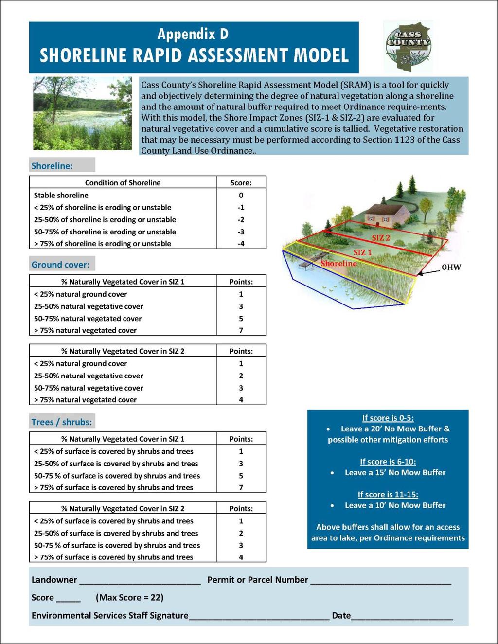
125 125
ORDINANCE# ** LAND USE ORDINANCE FOR CASS COUNTY, MINNESOTA
 11111111111111111111111111111111111111111111111111111111111111111111111111111111 Page 3 of 200 AOOOG296SS ORDINANCE# 2005-01** LAND USE ORDINANCE FOR CASS COUNTY, MINNESOTA **--Incorporating Amendments
LAND USE ORDINANCE EFFECTIVE DATE: April 22, 2011
 LAND USE ORDINANCE EFFECTIVE DATE: April 22, 2011 Revised: 4-10-12, 7-25-12, 10-9-12, 1-26-13, 4-20-13, 7-27-13, 10-19-13 2-26-14, 4-23-14, 7-16-14. 01-14-15, 1-11-17, 07-11-2017, 11-22-2017 TABLE OF CONTENTS
Castle Danger Subordinate Service District Phase I Land Use Ordinance #1
 Castle Danger Subordinate Service District Phase I Land Use Ordinance #1 Effective February 2, 2010 Castle Danger Subordinate Service District Phase I Land Use Ordinance SECTION I PURPOSE The purpose of
CHECKLIST INFORMATION NECESSARY FOR ZONING PERMITS
 Information for Zoning Permits (Updated: 2016.11.04 Itasca County Environmental Services 123 NE 4 th Street Grand Rapids, MN 55744 Phone: (218) 327-2857 Fax: (218) 327-7331 TDD: (218) 327-2806 Fax: (218)
ARTICLE 1 GENERAL PROVISIONS
 ARTICLE 1 GENERAL PROVISIONS SECTION 100 TITLE This Ordinance shall be known and cited as the "Rice Township Subdivision and Land Development Ordinance." SECTION 101 AUTHORITY Rice Township is empowered
Rice County Buffer Ordinance
 Rice County Buffer Ordinance CHAPTER 640 STATUTORY AUTHORIZATION AND PURPOSE 640.1 Statutory Authorization: This buffer ordinance is adopted pursuant to the authorization and policies contained in Minn.
PLEASE READ THIS IMPORTANT INFORMATION REGARDING VARIANCE APPLICATIONS
 PLEASE READ THIS IMPORTANT INFORMATION REGARDING VARIANCE APPLICATIONS I. APPLICATION Complete the Variance Application. The Environmental Services staff will provide assistance in filling out forms and
ARTICLE 2: General Provisions
 ARTICLE 2: General Provisions 2-10 Intent The basic intent of the Town of Orange s Zoning Ordinance is to implement the goals and objectives of the adopted Town of Orange Comprehensive Plan, hereafter
TABLE OF CONTENTS CHAPTER 1 INTRODUCTORY PROVISIONS Section 1 Purposes. 6. Section 2 Statutory Authorization. 7.
 An Ordinance requiring permits for buildings, structures and the uses thereof; for land uses and for water supply and sewage treatment facilities; establishing minimum lot sizes, setbacks and side yards,
ORDINANCE # CASS COUNTY INDIVIDUAL SEWAGE TREATMENT SYSTEM ORDINANCE
 ORDINANCE #2007-02 CASS COUNTY INDIVIDUAL SEWAGE TREATMENT SYSTEM ORDINANCE EFFECTIVE DATE: May 25, 2007 TABLE OF CONTENTS SECTION 1. GENERAL PROVISIONS... 3 1.10 PURPOSE AND JURISDICTION.... 3 1.30 OBJECTIVES....
201 General Provisions
 201 General Provisions 201.01 Title 201.09 Amendments 201.02 Purpose and Intent 201.10 Public Purpose 201.03 Authority 201.11 Variances and Appeals 201.04 Jurisdiction 201.12 Nonconformances 201.05 Enactment
WAYNE COUNTY, UTAH SUBDIVISION ORDINANCE
 WAYNE COUNTY, UTAH SUBDIVISION ORDINANCE A LAND USE ORDINANCE OF WAYNE COUNTY As Adopted by the Wayne County Board of County Commissioners Effective January 01, 2011 Prepared by: PLANNING AND DEVELOPMENT
PIKE TOWNSHIP, OHIO July 6, 2010 ZONING REGULATIONS
 CHAPTER 9 - ADMINISTRATION AND ENFORCEMENT Section A - General Provisions The formulation, administration, and enforcement of these Zoning Regulations is hereby vested in the following offices of Clark
Instructions to the Applicant
 CONDITIONAL USE PERMIT APPLICATION Lake of the Woods County Land and Water Planning Office 206 8 th Avenue Southeast, Suite #290 Baudette MN 56623-2867 www.co.lake-of-the-woods.mn.us Phone: (218) 634-1945
ARTICLE III GENERAL PROCEDURES, MINOR PLANS AND FEE SCHEDULES
 ARTICLE III GENERAL PROCEDURES, MINOR PLANS AND FEE SCHEDULES 301. Prior to Submission a. Copies of this Ordinance shall be available on request, at cost, for the use of any person who desires information
Title 6 - Local Government Provisions Applicable to Special Purpose Districts and Other Political Subdivisions
 Title 6 - Local Government Provisions Applicable to Special Purpose Districts and Other Political Subdivisions CHAPTER 29. SOUTH CAROLINA LOCAL GOVERNMENT COMPREHENSIVE PLANNING ENABLING ACT OF 1994 1994
HUERFANO COUNTY SIGN REGULATIONS SECTION 14.00
 TABLE OF CONTENTS Section Title Page 14.01 SIGN CODE... 14-1 14.01.01 Intent and Purpose... 14-1 14.02 GENERAL PROVISIONS... 14-1 14.02.01 Title... 14-1 14.02.02 Repeal... 14-1 14.02.03 Scope and Applicability
MILLE LACS COUNTY BUFFER ORDINANCE
 MILLE LACS COUNTY BUFFER ORDINANCE ARTICLE ONE: STATUTORY AUTHORIZATION AND POLICY 101 STATUTORY AUTHORIZATION. This buffer ordinance is adopted pursuant to the authorization and policies contained in
ARTICLE XX THE COUNTY BOARD OF MERCER COUNTY, ILLINOIS RESOLUTION AMENDING THE MERCER COUNTY ZONING ORDINANCE SOLAR ENERGY FACILITIES
 ARTICLE XX THE COUNTY BOARD OF MERCER COUNTY, ILLINOIS RESOLUTION AMENDING THE MERCER COUNTY ZONING ORDINANCE SOLAR ENERGY FACILITIES 20.1 TITLE. This ordinance shall be known as the Solar Energy Ordinance.
WASHINGTON COUNTY BUFFER ORDINANCE TABLE OF CONTENTS
 WASHINGTON COUNTY BUFFER ORDINANCE TABLE OF CONTENTS SECTION 1. PURPOSE AND AUTHORITY... 2 SECTION 2. SCOPE... 2 SECTION 3 DEFINITIONS... 2 SECTION 4 JURISDICTION... 4 SECTION 5 BUFFER REQUIREMENTS...
ARTICLE XXIII ADMINISTRATION
 ARTICLE XXIII ADMINISTRATION 20 2301. Duties of the Zoning/Code Enforcement Officer The Zoning/Code Enforcement Officer shall be appointed by the Board of Supervisors and may hold no elective office in
OTTER TAIL COUNTY SANITATION CODE for SUBSURFACE SEWAGE TREATMENT SYSTEMS
 OTTER TAIL COUNTY SANITATION CODE for SUBSURFACE SEWAGE TREATMENT SYSTEMS Incorporating By Reference MINNESOTA RULES CHAPTERS 7080, 7081, AND 7082 With Some Local Modifications Effective Date: April 26,
ARTICLE 5 GENERAL REQUIREMENTS
 5.1 SUITABILITY OF THE LAND ARTICLE 5 GENERAL REQUIREMENTS 5.1.1 Land subject to flooding, improper drainage or erosion, and land deemed to be unsuitable for development due to steep slope, unsuitable
ARTICLE 8C SITE CONDOMINIUM DEVELOPMENT ORDINANCE
 ARTICLE 8C SITE CONDOMINIUM DEVELOPMENT ORDINANCE SECTION 8C.01 PURPOSE It is the purpose of this Ordinance to insure that plans for development within Oceola Township proposed under the provisions of
STAFF REPORT. Arthur and Kathleen Quiggle 4(b)
") STAFF REPORT Application: Requests related to the construction of a 28' x 41' dwelling and 6' wrap-around open deck to replace an existing 24' x 32' cabin and wrap-around open deck and the installation
STAFF REPORT Application: Requests related to the construction of a 28' x 41' dwelling and 6' wrap-around open deck to replace an existing 24' x 32' cabin and wrap-around open deck and the installation
Chapter 136. SOIL EROSION
 1 of 8 12/19/2011 4:17 PM Township of Andover, NJ Monday, December 19, 2011 Chapter 136. SOIL EROSION [HISTORY: Adopted by the Township Committee of the Township of Andover by Ord. No. 77-11 (Ch. XVII
TOWN OF WATERVILLE VALLEY NEW HAMPSHIRE SITE PLAN REVIEW REGULATIONS
 TOWN OF WATERVILLE VALLEY NEW HAMPSHIRE Effective date March 17, 1981 Revised March 16, 1982 Revised March 13, 1986 Revised March 10, 1987 Revised March 14, 2013 Revised March 8, 2016 TOWN OF WATERVILLE
ST. JOSEPH TOWNSHIP RESOLUTION CITY OF ST. JOSEPH RESOLUTION 2018-
 ST. JOSEPH TOWNSHIP RESOLUTION 2018- CITY OF ST. JOSEPH RESOLUTION 2018- JOINT RESOLUTION FOR DESIGNATION OF AN AREA FOR ORDERLY ANNEXATON AND FOR DESIGNATION OF AN AREA FOR IMMEDIATE ANNEXATION PURSUANT
Cartersville Code of Ordinances Historic Preservation Commission
 Cartersville Code of Ordinances Historic Preservation Commission Sec. 9.25-31. Purpose Sec. 9.25-32. Historic preservation commission. Sec. 9.25-33. Recommendation and designation of historic districts
WILLIAMSON ACT CONTRACTS GUIDELINES
 NEVADA COUNTY COMMUNITY DEVELOPMENT AGENCY PLANNING DEPARTMENT ERIC ROOD ADMINISTRATION BUILDING 950 Maidu Avenue Nevada City, California 95959-8617 Phone: (530) 265-1222 FAX : (530) 265-9851 WILLIAMSON
St. Mary s County Comprehensive Zoning Ordinance Article 1. GENERAL PROVISIONS
 0 0 0 0 ARTICLE. GENERAL PROVISIONS CHAPTER 0 TITLE, PURPOSE AND ORGANIZATION Sections: 0. Title. 0. Authority. 0. Purpose. 0. Organization of the Zoning Ordinance. 0. Official Zoning Map. 0. Applicability.
Midwest City, Oklahoma Zoning Ordinance
 2010 Midwest City, Oklahoma Zoning Ordinance 9/2/2010 Table of Contents Section 1. General Provisions... 5 1.1. Citation... 5 1.2. Authority... 5 1.3. Purpose... 5 1.4. Nature and Application... 5 1.5.
DRAFT PARK COUNTY US HIGHWAY 89 SOUTH EAST RIVER ROAD OLD YELLOWSTONE TRAIL ZONING DISTRICT REGULATIONS
 Formatting: Changes recommended by the Board and accepted by the County Commission are formatted in RED: Changes made by the Park County Commission are formatted in YELLOW highlight: and changes made by
DRAFT PARK COUNTY US HIGHWAY 89 SOUTH EAST RIVER ROAD OLD YELLOWSTONE TRAIL ZONING DISTRICT REGULATIONS
 DRAFT PARK COUNTY US HIGHWAY 89 SOUTH EAST RIVER ROAD OLD YELLOWSTONE TRAIL ZONING DISTRICT REGULATIONS I. TITLE These regulations and the accompanying map(s) shall be known as, and shall be cited and
Beltrami County Shoreland Management Ordinance
 Beltrami County Shoreland Management Ordinance Effective TBD May 5, 1992 Amended: July 1, 1997, May 4, 2004, February 7, 2006 and December 12, 2006 New Language Deleted language 1 SHORELAND MANAGEMENT
Pipestone County Buffer Ordinance
 Pipestone County Buffer Ordinance 1.0 STATUTORY AUTHORIZATION AND POLICY 1.1 Statutory authorization. This buffer ordinance is adopted pursuant to the authorization and policies contained in Minn. Stat.
OPEN SPACE TIMBER PROGRAM OKANOGAN COUNTY CODE, CHAPTER 14.09
 OPEN SPACE TIMBER PROGRAM OKANOGAN COUNTY CODE, CHAPTER 14.09 14.09.010 - Short Title 14.09.020 - Purpose 14.09.030 - Administration 14.09.040 - Compliance with Regulations 14.09.050 - Scope 14.09.060
SECTION 23 SUBSURFACE SEWAGE TREATMENT SYSTEM ORDINANCE (SSTS)
") SECTION 23 SUBSURFACE SEWAGE TREATMENT SYSTEM ORDINANCE (SSTS) A. Section One - Purpose The purpose of the Subsurface Sewage Treatment System Ordinance shall be to provide minimum standards for and regulation
SECTION 23 SUBSURFACE SEWAGE TREATMENT SYSTEM ORDINANCE (SSTS) A. Section One - Purpose The purpose of the Subsurface Sewage Treatment System Ordinance shall be to provide minimum standards for and regulation
Charter Township of Plymouth Zoning Ordinance No. 99 Page 208 Article 21: Residential Unit Developments Amendments: ARTICLE XXI
 Charter Township of Plymouth Zoning Ordinance No. 99 Page 208 ARTICLE XXI RESIDENTIAL UNIT DEVELOPMENTS PURPOSE The purpose of the Residential Unit Development (RUD) is to permit two (2) optional methods
Town of Bristol Rhode Island
 Town of Bristol Rhode Island Subdivision & Development Review Regulations Adopted by the Planning Board September 27, 1995 (March 2017) Formatted: Highlight Formatted: Font: 12 pt Table of Contents TABLE
Land Use Ordinance. Town of Readfield, Maine. Adopted June 12, 2018
 Land Use Ordinance Town of Readfield, Maine Adopted June 12, 2018 Revised: March 20, 2000; June 14, 2001; September 17, 2001; June 13, 2002; June 12, 2003; September 15, 2004; June 15, 2006; June 16, 2007;
TOWN OF ENNIS TITLE 11 ZONING ORDINANCE DRAFT UPDATE
 TOWN OF ENNIS TITLE 11 ZONING ORDINANCE DRAFT UPDATE FEBRUARY 6, 2018 CHAPTER 1: TITLE, PURPOSE, AUTHORITY, AND GENERAL ADMINISTRATIVE PROVISIONS The regulations, standards, and procedures contained herein
SIBLEY COUNTY. Article 330 Buffer Ordinance of the Code of Ordinances of the County of Sibley
 SIBLEY COUNTY Article 330 Buffer Ordinance of the Code of Ordinances of the County of Sibley ARTICLE 330. BUFFER ORDINANCE SECTION 330.1 STATUTORY AUTHORIZATION AND POLICY SUBD 330.1.1 Statutory Authorization
Deerfield Township Zoning Resolution
 Deerfield Township Zoning Resolution Effective August 5, 2011 Amended December 1, 2016 TABLE OF CONTENTS Article 1: General Provisions... 1-1 Section 1.01: Title... 1-1 Section 1.02: Purpose... 1-1 Section
Buffer and Soil Loss Statutes, as amended in 2017 by Laws of Minnesota 2017, Chapter 93 (S.F. 844)
") Buffer and Soil Loss Statutes, as amended in 2017 by Laws of Minnesota 2017, Chapter 93 (S.F. 844) May 30, 2017 103B.101 BOARD OF WATER AND SOIL RESOURCES Subd. 12. Authority to issue penalty orders. (a)
Buffer and Soil Loss Statutes, as amended in 2017 by Laws of Minnesota 2017, Chapter 93 (S.F. 844) May 30, 2017 103B.101 BOARD OF WATER AND SOIL RESOURCES Subd. 12. Authority to issue penalty orders. (a)
Village of South Elgin, IL. CHAPTER 156: Unified Development Ordinance
 Village of South Elgin, IL CHAPTER 156: Unified Development Ordinance UNIFIED DEVELOPMENT ORDINANCE (UDO) EFFECTIVE DATE: October 1, 2018 1 TABLE OF CONTENTS SECTION 156.01: TITLE AND APPLICABILITY...4
CHAPTER 3 PERMITS, PLANS AND ANNEXATION
 CHAPTER 3 PERMITS, PLANS AND ANNEXATION SECTION: 10-3-1: General Regulations 10-3-2: Building Permit 10-3-3: Plans 10-3-4: Certificate of Compliance and Occupancy 10-3-5: Conditional Use Permits 10-3-6:
PENINSULA TOWNSHIP LAND DIVISION ORDINANCE TOWNSHIP OF PENINSULA COUNTY OF GRAND TRAVERSE, STATE OF MICHIGAN ORDINANCE NO OF 2012
 PENINSULA TOWNSHIP LAND DIVISION ORDINANCE TOWNSHIP OF PENINSULA COUNTY OF GRAND TRAVERSE, STATE OF MICHIGAN ORDINANCE NO OF 2012 AN ORDINANCE TO REGULATE THE DIVISION OF EXISTING PARCELS OF LAND PURSUANT
LOCAL LAW NO. 2, 1987 A LOCAL LAW REGULATING EXCAVATION AND TOPSOIL REMOVAL WITHIN THE TOWN OF CAMBRIA
 LOCAL LAW NO. 2, 1987 A LOCAL LAW REGULATING EXCAVATION AND TOPSOIL REMOVAL WITHIN THE TOWN OF CAMBRIA PASSED BY TOWN OF CAMBRIA TOWN BOARD SEPTEMBER 3, 1987 Be it enacted by the Town Board of the Town
EXCERPTS FROM HALIFAX REGIONAL MUNICIPALITY CHARTER
 EXCERPTS FROM HALIFAX REGIONAL MUNICIPALITY CHARTER Municipal planning strategy 227 The Council may adopt a municipal planning strategy for all, or part, of the Municipality and there may be separate strategies
CHAPTER 18 SUBDIVISION AND PLATTING ORDINANCE OF THE TOWN OF OSCEOLA CODE OF ORDINANCES
 TOWN OF OSCEOLA POLK COUNTY WISCONSIN ORDINANCE # 18-03-03 CHAPTER 18 SUBDIVISION AND PLATTING ORDINANCE OF THE TOWN OF OSCEOLA CODE OF ORDINANCES 18.01 Purpose Adopted 3/08/99, Amended 5/12/03, 7/9/07,
BONNER COUNTY PLANNING DEPARTMENT
 BONNER COUNTY PLANNING DEPARTMENT 1500 HIGHWAY 2, SUITE 208, SANDPOINT, ID 83864 (208) 265-1458 (208) 265-1463 (FAX) planning@bonnercountyid.gov (email) www.bonnercounty.us (web page) INFORMATION SHEET
CHARTER TOWNSHIP OF SUPERIOR WASHTENAW COUNTY, MICHIGAN PRIVATE ROAD ORDINANCE ORDINANCE NO. 163
 PAGE 163-1 CHARTER TOWNSHIP OF SUPERIOR WASHTENAW COUNTY, MICHIGAN PRIVATE ROAD ORDINANCE ORDINANCE NO. 163 AN ORDINANCE OF THE CHARTER TOWNSHIP OF SUPERIOR ESTABLISHING PROVISIONS FOR APPROVAL OF PRIVATE
This Ordinance is adopted under the authority and provisions of the General Statutes of North Carolina, Article 6, Chapter 153A 121.
 Section 74, Regulations Governing Manufactured Home Parks 1. Purpose The purpose of these regulations to be known and cited as the Madison County Manufactured Home Park Ordinance is to regulate and guide
WEBSTER TOWNSHIP LAND DIVISION ORDINANCE. Summary Table of Amendments
 WEBSTER TOWNSHIP LAND DIVISION ORDINANCE Ordinance No. 2012 02 As Adopted 04-17-12 Summary Table of Amendments Adoption Date Affected Sections Summary October 10, 3 Added definition of Township Engineer
TOWNSHIP OF HARTLAND ORDINANCE NO. 57-1, AN ORDINANCE AMENDING THE LAND DIVISION ORDINANCE
 TOWNSHIP OF HARTLAND ORDINANCE NO. 57-1, AN ORDINANCE AMENDING THE LAND DIVISION ORDINANCE An ordinance to amend the Land Division Ordinance enacted pursuant to but not limited to the State Land Division
WAKE COUNTY SUBDIVISION ORDINANCE ANNOTATED
 WAKE COUNTY SUBDIVISION ORDINANCE ANNOTATED The Wake County Subdivision Ordinance makes up Chapters 3-1 through 3-5 of the Wake County Code of General Ordinances (as reflected in the numbering of its sections).
Special Use Permit - Planned Unit Development Checklist. Property Address:
 Special Use Permit - Planned Unit Development Checklist Special Use Permit Number. Parcel Code/s #28-11- - - Property Address: Applicant: ARTICLE VIII Ordinance Reference - Section 8.1.2 Permit Procedures:
Planning and Zoning Code
 2014 Planning and Zoning Code City of Defiance, Ohio December 2014 Planning and Zoning Code City of Defiance, Ohio CHAPTER 1161. General Provisions... 7 1161. 01. Title... 7 1161. 02. Purpose... 7 1161.
MOBILE HOME PARK ORDINANCE OF THE TOWN OF LIVERMORE FALLS
 1 Section I. TITLE MOBILE HOME PARK ORDINANCE OF THE TOWN OF LIVERMORE FALLS This ordinance shall be known and cited as the Mobile Home Park Ordinance of the Town of Livermore Falls, Maine. Section II.
THEREFORE BE IT RESOLVED
 INGHAM COUNTY HEALTH DEPARMENT REGULATION AMENDING THE SANITARY CODE BY ADDING CHAPTER VII REGULATIONS FOR THE INSPECTION OF ONSITE WATER AND SEWAGE DISPOSAL SYSTEMS AT THE TIME OF PROPERTY TRANSFER PREAMBLE:
Short Title This Chapter shall be known and cited as the Open Space Open Space Program and Public Benefit Rating System.
 CHAPTER 14.08 OPEN SPACE OPEN SPACE PROGRAM AND PUBLIC BENEFIT RATING SYSTEM SECTIONS: 14.08.0 10 - Short Title 14.08.020 - Purpose 14.08.030 - Administration 14.08.040 - Compliance with Regulations 14.08.050
Administrative Penalty Order (APO) Plan for Buffer Law Implementation
 Plan for Buffer Law Implementation") Administrative Penalty Order (APO) Plan for Buffer Law Implementation June 28, 2017 This document was adopted by the Board of Water and Soil Resources (BWSR) pursuant to Minn. Stat. 103B.101, subd. 12(a)
Administrative Penalty Order (APO) Plan for Buffer Law Implementation June 28, 2017 This document was adopted by the Board of Water and Soil Resources (BWSR) pursuant to Minn. Stat. 103B.101, subd. 12(a)
Draft Zoning Changes for the 2nd Planning Board Public Hearing, January 22, 2018.
 Draft Zoning Changes for the 2nd Planning Board Public Hearing, January 22, 2018. No changes were made at the 1st Public Hearing. Proposed wording for the 1 st Public Hearing in red, eliminated text in
CHAPTER XVIII SITE PLAN REVIEW
 CHAPTER XVIII SITE PLAN REVIEW Section 18.1 Section 18.2 Description and Purpose. The purpose of this chapter is to provide standards and procedures under which applicants would submit, and the Township
CHAPTER 10 Planned Unit Development Zoning Districts
 CHAPTER 10 Planned Unit Development Zoning Districts Section 10.1 Intent and Purpose The Planned Unit Development (PUD) districts are intended to offer design flexibility for projects that further the
CHARTER TOWNSHIP OF KALAMAZOO KALAMAZOO COUNTY, MICHIGAN ORDINANCE NO. KALAMAZOO CHARTER TOWNSHIP SIDEWALK ORDINANCE
 CHARTER TOWNSHIP OF KALAMAZOO KALAMAZOO COUNTY, MICHIGAN ORDINANCE NO. KALAMAZOO CHARTER TOWNSHIP SIDEWALK ORDINANCE An Ordinance enacted pursuant to Michigan Public Act 246 of 1931 and Public Act 359
RESOLUTION NO ORDINANCE NO. 02-1
 RESOLUTION NO. 020828-1 ORDINANCE NO. 02-1 CHISAGO COUNTY, MINNESOTA AN ORDINANCE AMENDING SECTION 7.27 OF THE CHISAGO COUNTY ZONING ORDINANCE CONCERNING MINERAL EXTRACTION THE BOARD OF COUNTY COMMISSIONERS
PART 1 JURISDICTION, ZONING DISTRICTS, AND LAND USES
 PART 1 JURISDICTION, ZONING DISTRICTS, AND LAND USES ARTICLE 1 TITLE, PURPOSE, JURISDICTION, AND APPLICABILITY Division 1-1.1 Title and Reference Sec. 1-1.1.1 Title This Ordinance shall be known as "The
13 NONCONFORMITIES [Revises Z-4]
![13 NONCONFORMITIES [Revises Z-4]](/thumbs/87/97238669.jpg "13 NONCONFORMITIES [Revises Z-4]") Dimensional Standards Building Design Standards Sidewalks Tree Protection & Landscaping Buffers & Screening Street Tree Planting Parking Lot Landscaping Outdoor Lighting Signs 13.1 PURPOSE AND APPLICABILITY
Dimensional Standards Building Design Standards Sidewalks Tree Protection & Landscaping Buffers & Screening Street Tree Planting Parking Lot Landscaping Outdoor Lighting Signs 13.1 PURPOSE AND APPLICABILITY
MINNESOTA POLLUTION CONTROL AGENCY GENERAL PERMIT FOR DISPOSAL OF UNCOMTAMINATED CONCRETE
 MINNESOTA POLLUTION CONTROL AGENCY GENERAL PERMIT FOR DISPOSAL OF UNCOMTAMINATED CONCRETE ISSUANCE DATE: December 23, 2013 EXPIRATION DATE: December 23. 2018 This permit is a General Permit issued pursuant
Beltrami County Shoreland Management Ordinance
 Beltrami County Shoreland Management Ordinance Effective August 1, 2017 May 5, 1992 Amended: July 1, 1997, May 4, 2004, February 7, 2006 and December 12, 2006 New Language Deleted language 1 SHORELAND
LEMHI COUNTY DEVELOPMENT CODE
 LEMHI COUNTY DEVELOPMENT CODE Adopted June 12, 2017 Ordinance Number 2017-1 Repealing Ordinance No. 2012-1 and subsequent amendments in its entirety. County Commissioners Ken Miner, Rick Snyder & Brett
Open Space Taxation Act
 Open Space Taxation Act WASHINGTON STATE DEPARTMENT OF REVENUE JUNE 2007 The information and instructions in this brochure are to be used when applying for assessment on the basis of current use under
ARTICLE VII. NONCONFORMITIES. Section 700. Purpose.
 ARTICLE VII. NONCONFORMITIES. Section 700. Purpose. The purpose of this chapter is to regulate and limit the development and continued existence of legal uses, structures, lots, and signs established either
Town of Lincolnville Subdivision Ordinance
 Town of Lincolnville Subdivision Ordinance November 8, 2005 Amended: 06-10-2008---Article 4, Section 4.4.1 Conceptual Plan 06-11-2015---Article 5, Section 5.2.3.i., Article 6.2.3.l., Article 8 & 12 Access
Public Hearing Draft Zoning Ordinance ARTICLE I Administration
 Administration ARTICLE I Public Hearing Draft Zoning Ordinance ARTICLE I Administration Adopted July, 2013 Administration ARTICLE I Table of Contents Chapter 18.02 Purpose and Applicability... I-1 Chapter
TOWNSHIP OF WANTAGE ORDINANCE #
 TOWNSHIP OF WANTAGE ORDINANCE #2018-10 AN ORDINANCE OF THE TOWNSHIP OF WANTAGE, COUNTY OF SUSSEX, STATE OF NEW JERSEY, AMENDING CHAPTER 23 OF THE TOWNSHIP OF WANTAGE REVISED GENERAL ORDINANCES ENTITLED
SECTION 3.1 Zoning Permit Required for Construction, Land Use and Development.
 CHAPTER 3 ADMINISTRATION, FEES AND ENFORCEMENT SECTION 3.1 Zoning Permit Required for Construction, Land Use and Development. A. Zoning Permit Required. A zoning permit is required for any of the following
CHAPTER 22 SUBDIVISION AND LAND DEVELOPMENT. Part 1 General Provisions. Part 2 Application Procedure and Approval Process
 CHAPTER 22 SUBDIVISION AND LAND DEVELOPMENT Part 1 General Provisions 101. Title 102. Policy 103. Purposes 104. Authority 105. Jurisdiction 106. Interpretation, Conflict and Separability 107. Municipal
ORDINANCE NO. _4.06 AN ORDINANCE TO ESTABLISH BUILDING SITE REGULATIONS SECTION A PURPOSE AND INTENT
 ORDINANCE NO. _4.06 AN ORDINANCE TO ESTABLISH BUILDING SITE REGULATIONS SECTION A PURPOSE AND INTENT This Ordinance provides minimum regulations, provisions and requirements for safe, aesthetically pleasing
Town of Norwich, Vermont SUBDIVISION REGULATIONS
 Town of Norwich, Vermont SUBDIVISION REGULATIONS Adopted: August 6, 2002 Amended: February 8, 2006 Prepared by Norwich Planning Commission with the assistance of: Burnt Rock Inc. A ssociates in Community
SUBDIVISION APPLICATION
 SUBDIVISION APPLICATION Community Planning and Economic Development Development Services Division 250 South 4 th Street, Room 300 Minneapolis MN 55415-1316 612-673-3000 This application packet is used
Chapter 100 Planned Unit Development in Corvallis Urban Fringe
 100.100 Scope and Purpose. Chapter 100 Planned Unit Development in Corvallis Urban Fringe (1) All applications for land divisions in the Urban Residential (UR) and Flood Plain Agriculture (FPA) zones within
CHAPTER 352 COUNTY LAND PRESERVATION AND USE COMMISSIONS
 CHAPTER 352 COUNTY LAND PRESERVATION AND USE COMMISSIONS Referred to in 6B.3, 15E.111, 159.6, 173.3, 455B.275 Chapter does not invalidate ordinances existing on July 1, 1982, or require adoption of zoning
Town of Prairie du Sac Sauk County, WI. Land Division Ordinance 07-3
 Town of Prairie du Sac Sauk County, WI Land Division Ordinance 07-3 1.01 DISCLAIMER (1) Multiple Jurisdictions. All persons reviewing the provisions of this Ordinance should be aware that the Town of Prairie
SECTION 1 INTRODUCTION TO THE PANAMA CITY BEACH COMPREHENSIVE GROWTH DEVELOPMENT PLAN
 1. PURPOSE SECTION 1 INTRODUCTION TO THE PANAMA CITY BEACH COMPREHENSIVE GROWTH DEVELOPMENT PLAN The purpose of the City of Panama City Beach's Comprehensive Growth Development Plan is to establish goals,
Section 7.22: Multifamily Assisted Housing in AA-30 Residential Zone (MAHZ) [Note: an additional line will be added to the Table in Article 3, 3.1.
 [Note: an additional line will be added to the Table in Article 3, 3.1.") Section 7.22: Multifamily Assisted Housing in AA-30 Residential Zone (MAHZ) [Note: an additional line will be added to the Table in Article 3, 3.1.1A] 7.22.1 Purpose The purpose of this Special Regulation
Section 7.22: Multifamily Assisted Housing in AA-30 Residential Zone (MAHZ) [Note: an additional line will be added to the Table in Article 3, 3.1.1A] 7.22.1 Purpose The purpose of this Special Regulation
Residential Project Convenience Facilities
 Standards for Specific Land Uses 35.42.220 E. Findings. The review authority shall approve a Land Use Permit in compliance with Subsection 35.82.110.E (Findings required for approval) or a Conditional
1.1 ENACTMENT AND AUTHORITY
 ARTICLE 1. LEGAL PROVISIONS 1.1 ENACTMENT AND AUTHORITY These regulations are adopted pursuant to the authority vested in the Town of Dobson by its charter, the Session laws, and the General Statutes of
This Ordinance shall be known as the Zoning Ordinance of the Town of Holly Ridge, North Carolina.
 CHAPTER 7. ZONING ARTICLE I. LEGAL PROVISIONS Section 7.1 Enactment and Authority The Town Council of the Town of Holly Ridge, North Carolina pursuant to the authority granted by Article 1, Chapter 160A
The following regulations shall apply in the R-E District:
 "R-E" RESIDENTIAL ESTATE DISTRICT (8/06) The following regulations shall apply in the R-E District: 1. Uses Permitted: The following uses are permitted. A Zoning Certificate may be required as provided
TOWN OF AVON ZONING ORDINANCE
 TOWN OF AVON ZONING ORDINANCE Certified: Advisory Plan Commission September 24, 2002 Adopted: Avon Town Council: November 14, 2002 Ordinance 2002-14 Subsequent Amendments Avon Town Council Ordinance 2003-06
BOARD OF COUNTY COMMISSIONERS ARCHULETA COUNTY, COLORADO RESOLUTION 2018-
 BOARD OF COUNTY COMMISSIONERS ARCHULETA COUNTY, COLORADO RESOLUTION 2018- ARCHULETA COUNTY IMPROPERLY DIVIDED PARCELS EXEMPTION INTERIM RESOLUTION - A RESOLUTION ADDRESSING PARCELS UNDER THE SIZE OF 35
UNIFORM RULE 5. Administration of Williamson Act Contracts
 UNIFORM RULE 5 Administration of Williamson Act Contracts I. PROCEDURE TO ESTABLISH AN AGRICULTURAL PRESERVE AND WILLIAMSON ACT CONTRACT See Appendices 1 and 2 for the following forms: Application Form
BROCHURE # 37 OPEN SPACE
 BROCHURE # 37 OPEN SPACE The information and instructions in this publication are to be used when applying for assessment on the basis of current use under the open space laws, chapter 84.34 RCW and chapter
PONDS. A. Definitions.
 A. Definitions. PONDS For purposes of this section, the following terms shall have the following meanings: 1. Application means all documents, forms and other information that the Department may require
COUNCIL BILL NO ORDINANCE NO. 3594
 COUNCIL BILL NO. 17-1037 ORDINANCE NO. 3594 AN ORDINANCE AMENDING THE MUNICIPAL CODE OF THE CITY OF COEUR D'ALENE, KOOTENAI COUNTY, IDAHO, ADDING A NEW ARTICLE X, SHORT-TERM RENTALS, TO CHAPTER 17.08 OF
LANGLADE COUNTY ANIMAL WASTE STORAGE ORDINANCE
 Langlade County Code of Ordinances Chapter 24 Ordinance #2-2001 LANGLADE COUNTY ANIMAL WASTE STORAGE ORDINANCE 24.01 AUTHORITY This ordinance is adopted under authority granted by Section 59.02 and 92.16,
Boyertown Borough and Colebrookdale and Pike Townships Joint Zoning Ordinance
 Boyertown Borough and Colebrookdale and Pike Townships Joint Zoning Ordinance Berks County, Pennsylvania Effective Date - November 7, 2010 This Ordinance was prepared under the direction of the Boyertown