CITY OF BAYTOWN. Universal Development Application
|
|
|
- Kristina Turner
- 6 years ago
- Views:
Transcription
1 CO CITY OF BAYTOWN Universal Development Application Pfenning A: Development Sen-ices 2401 Market Street Biyuwit,TX 7T520 Rhone; 28l-42f»-53W Planrriirg&baylottc-org Incomplete applications will not be accepted. Indicate "N/A" when an item does not pertain toyour application. APPLICATION TYPE(S) - CHECK APPROPRIATE BOX(ES) BELOW -ric Zoning Map Amendment DTelecommunication Special Us Replat Land Development Plan n^l Zoning Variance Landscape Variance Small Subdivision* rjz Zoning Special Exception rrt Zoning Appeal n Subdivision Variance Preliminary Plat* o Lot Line Adjustment/Consolidation Minor Plat* Fire Lane Easement Amending Plat* c Text Amendment ^j/zoning Special Use Final Plat* d Plat Certification o Other ifae appropriate checklist and lee schedule for minimum requirements for each application. *These applications use the same checklist. O PROJECT INFORMATION.. Project Subdivision Name: So.vjrov^^\ W\q.>T\vnc^ RV Rgsor-V" Project Address/Location: \5*2. lo^gs CocxA QavjrQU)^ Brief Description of Project: G~oysS^<*OeVvow- Q^ QV rorv-- PROPERTY INFORMATION - THIS SECTION DOES NOT APPLY TO TEXT CHANGES Legal Description &Recording Info: V\g/<\^ CjCXirJr*^ K.QV5.\j->Jg_ Oa\>AOOJr\ TAOsftHCX Parcel(s) Tax ID//(s): V>lg^l CPODDDOJ. Property platted: Yes2L. No Don't Know Type: Residential Acres:. CommercialiiAcres: ^, Total acres: Is property in ETJ? Yes No Existing Zoning: JjSgu. Number ofexisting lots: \, Number ofexisting units: O, Current Use: VOQCwT Proposed Zoning: uve. Number of proposed lots:. Number of proposed units:, Proposed Use:'C>«vO»vr- Utility provider for water supply: C\Vu pv \SqvAouJAUtility provider for sanitary sewer:ciyxa q\ ijcx\^ye yj i would like to attend a meeting with the Development Review Committee (DRCj: Yes jz.no County: Chambers HarrisAsr [I'nmarv Contact will be notified) Owner Name: 0\nM NOs \ WN.ixg.v^» Address: lao^ VL\\o^om e- SL^o^cK Phone: Applicant Name: V^,V"e*~ APPLICANT & OWNER LNFORMATION Fax: XSVJOAfeS Address: CJ3 ^Vtjqns Urrv^ Phone: ^V?fl_- V^lr 3C7.1 Fax: Contact Person (Ifdifferent from applicant): Address: CX^ OJOQ\1Q_ lovev56(5)msn.com City. fi>ckvaov^ <v State:T^ Zip: C^ov^^ftfOp^\\/\ o> ^^uu-co** litsysxicyo. C>\x StnteT^ ZipHlE)13 Citv: State: Zip: rv Phone: Fax: By signing this application, staff is "ranted access to your proper!) lo perform activities related to your case. If the property owner is not signing, legally sufficient signatureauthorityverification (i.e. letterof authorization to apply) must be provided at the timeof application. iuaj/tufu* Signature(s): Printed/Typed Namc(s): OLIVIA MYERS Known 10 me to be the person(s)whosenamc(s) is/are subscribed to the aboveand foregoing instrument, and acknowledged to me that they executed the same fejlhe purposes andconsideration uon expressed and in the capacity therein slated. Given under my hand and seal ofoffice on this Project dav of Manager; X Completeness review by:_ 20 \L TRESSIAYARBROUGH NOTARY PUBLIC STATE OF TEXAS CQMM V^ ^Ju^CQt=^-~ ; DENT USE ONLY: Submittal Date: Accepted By: Total Fee(s): S Date: Approved by: Approval Date: Project ; :pafj^ddio Re\

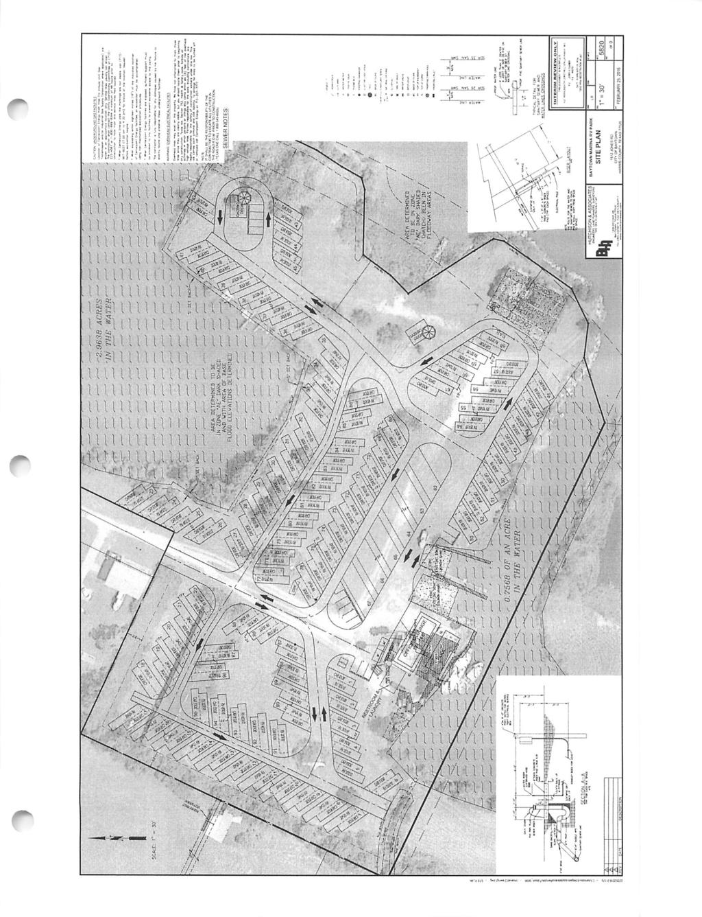
2 Baytown Marina RV Resort Zoning Special Use Checklist Applicant's Statement ' The statement shall: list the reason(s) for requiring a zoning special use permit.' To construct and operate a recreational vehicle park. ' identify the existing zoning district and the current and proposed property uses' Under the City of Baytown Unified Land Development Code the subject property is in a Mixed Use Zone. This zoning permits a recreational vehicle park subjectto the conditions specified in Section A31 of the code. (a) Recreational vehicle parks shall be separated from all adjacent uses by opaque screening Where the park area abuts adjoining property we propose six feet high timber screen panels in a staggered configuration that will minimize flood flow restriction. (b) must have an approved special use permit prior to receiving a building permit. The subject of this Application. (c) must be a minimum of 5 acres in size. The subject property is Acres. Land area is acres. Finally, the statement shall illustrate how the applicant's request addresses the following criteria: 1. This special use permit will be compatible with and not injurious to the use and enjoyment ofother property, not significantly diminish or impair property values within the immediate vicinity in any material way. We contend that a well designed destination recreational vehicle park in this location will not negatively impact on property values in the area. To the contrary, we believe the construction of Jones Road will have a positive effect on property values on properties fronting or accessing from this street. 2. This special usepermit will not impede the normal and orderly development and improvement of surrounding property Apart from the property to the north east that is zoned Multi Use, the property is surrounded by large holdings zoned Single Family Estate (SFE). We assume one reason for this zoning is that, in the main, these properties share the same flood plain as the subject property. The establishment of this RV park will not impede any further development of these sites that is currently permitted within the SFE Zone. 3. This special use permit will ensure that adequate utilities, access roads, drainage and other necessary supporting facilities have been orwill be provided prior to the issuance of a certificate ofoccupancy The engineering infrastructure will be designed by local engineering company, Busch Hutchinson and Associates and will meet the approval of the City of Baytown. A feature of the design will give us the ability to isolate electricity, water and sewer in the case of impending inundation.
3 4. This special use permit will ensure that adequate nuisance prevention measures will be taken and maintained to prevent and controloffensive odor, fumes, dust, noise and vibration priorto the issuance ofa certificate of occupancy. During construction measures will be taken to prevent sediment run off to Cedar Bayou. Depending on the time of construction it may be necessary to implement some dust abatement measures. During the park operation there will be no offensive odors, fumes, dust.noise or vibration 5. This special use permit will ensure that there are sufficient landscaping, screening, setbacks and otherland use measures to ensure harmony and compatibility with adjacent property The type of screening fence is specified by Section A31 of the Unified Land Development Code. We propose staggering these panels to facilitate the flood flow and supplement this screening with additional indigenous landscaping. The RV pads adjacent to adjoining properties are set back 20 feet from the property boundary. 6. The proposed use is in consistent with the comprehensive plan and is generally consistent with the ULDC. We believe the proposal meets the requirements specified in the ULDC. 7. That the site plan meets the criteria set forth in the ULDC Section 1.26 (e), whereas the Planning and Zoning Commission may recommend and the City Council may adopt otherconditions on any special use permit application that are needed to protect the public health, safety and welfare, including but not limited to, hours of operation and additional landscape or parking requirements We understand that the City Council may adopt other conditions that it may deem necessary before issuing a permit. The parking requirements specified in Section of the Code has been met or exceeded. The nature of an RV park operation means most business is conducted during business hours. Applicant(s) Signature Oi\OTO^ Date Applicant(s) Printed Name: Peter Charles Swales jfp\
4 A Proposal for a Recreational Vehicle Park on the site of the former Baytown Marina Jones Road Baytown. Baytown Marina RV Resort \ Area Background Prior to Hurricane Ike (and possibly after) this property appears to have been an operating marina, servicing commercial shipping, providing boat launching facilities, some boat marina pens and covered boat storage. At some later stage it was apparently a "Beer Hall". Since the cessation of these business activities the property has been unused apart from a couple of boat moorings and some locked storage areas in the old sheds. The property is becoming overgrown and has recently been the target of illegal rubbish dumpers. Numerous damaged boats and the remains of a travel trailer have been features of the site since Hurricane Ike. The property consists of Acres of both private water body and dry land. The actual dry land area of is Acres Adjacent to the south is an additional Acres of land, that although zoned residential, has no legal access to a public road. This initial proposal does not include this smaller tract. Physical Characteristics The land is situated on Cedar Bayou with elevations varying between two and eight feet. All of the subject property is contained with the 100 year Flood Plain and recent inundation is well documented. There is a combination of natural earth banks and a small area of bulk-headed waterfront. Some past works to prevent further erosion of the earth bank has been undertaken. These areas will need to be further stabilized and grassed There are some trees that we would be anxious to preserve and there is considerable areas of graveled hard stand. Existing buildings that are constructed of steel would form no part of the proposed development and would be demolished. The small building near the dock may serve as a temporary site office during the construction phase. We do not propose changing the physical layout of the land / water ratio. It is our intention to utilize the unique "peninsula" area to the north east and the inlet foreshore area adjacent to Jones Road as a nature walk / dog walking area. In accord with the City of Baytown Watershed Protection Code the average level of the property will not be altered.
5 The Proposal Our proposal is to develop the site into a destination recreational vehicle park with a strong fishing theme. There is no shortage of RV parks in the Baytown area, but few are of a standard to attract and retain recreational visitors, as most parks have understandably been targeted towards the many construction workers in the Baytown area. We believe our concept will appeal to those with boats, as well as shore fishermen who will be able to access a refurbished boat launching ramp as well as fishing piers in the inlet. The land area and physical shape of the site support around 100 sites designed in accord with Chapter 58 of the City of Baytown Ordinance and the requirements of Article V111 Watershed Protection Ordinance. The initial design has been commissioned after consultation with the relevant Officers of the City of Baytown. As a destination park we propose that the amenities will be of high standard including an elevated main building containing a members lounge and office reception area. A laundry and bathroom building is proposed at ground level. The later building will be designed to cope with occasional inundation and will be one of the few impediment to flood flow. The main structure will be elevated on piers to minimize restriction to flood flow. The only other structures required on site are a storage building for mowers etc and a small number of picnic shelters in "mini-parks" scattered throughout the park. A swimming pool area is envisaged and the adjacent 5 acre site could be used for passive pursuits that would not require infrastructure ie. walking tracks. Our research has shown that the issue of spacing is of high importance among recreational RV park users. With this in mind the designers have increased a percentage of site spacing up to twice the space specified by Section of the Baytown Code. Section specifies a minimum of 100 square feet of recreational area per RV stand. Our proposal includes a combination of private water body, watershed protection area and passive recreation area totaling approximately 220,000 square feet - an average of 2200sq feet per stand. In the event of pending inundation, services to the site such as power, sewer and water, will be isolated from a location above the flood level to ensure the health and safety of the local residents.

6 jp* * Why an RV park at 1512 Jones Road? We ask that the City of Baytown, and our neighbors in the Jones Road / Kilgore Road vicinity consider this proposal of a Destination RV Park as one of the best outcomes for this site for economic, aesthetic and practical reasons. 1. The site is in a 100 year flood plain. A condition in such an area is that any development does not significantly impede the maximum flow of water during time of flood. The permanent structures proposed will be far less than the footprint of the existing buildings. In the event of a severe weather warning (hurricane, storm surge etc.) our tenants will remove their vehicles and evacuate. 2. As part of the conditions of development our company will be constructing Jones Road to the "T" intersection. Construction will be to the standard set by the City of Baytown for an asphalt flexible base pavement. 3. This work will be undertaken at no cost to the City or landowners who abut the road. The new road will be enhanced by roadside landscaping. 4. This destination RV Park will attract longer term tenants with a common interest ie. Fishing. We would anticipate that a fair percentage of these folk would be retirees and their spending patterns would positively impact on local businesses. 5. All neighboring properties are part of a large lot subdivision and the residences are situated far from where the RV's will be located. Apart from our neighbor on the corner of Jones Road, the nearest residence will be around feet to the west. A 20 foot buffer zone and six foot fencing will shield the view of the park from adjoining properties zoned residential. 6. The current street scape consists of rusting derelict buildings, trash and obsolete infrastructure, with the land fast becoming overgrown. Illegal dumping is already in evidence. We intend that the public view (from the Jones Road T Intersection) will be replaced with landscaped areas and walk ways. 7. Within the site we intend to embark on a tree and shrub planting scheme (in accord with the relevant Ordinance) that will become a feature of the park. We will also be endeavoring to retain as many trees as possible during the construction phase. 8. Because of our commitment to the landscaped environment we anticipate the we will be employing more local people for site maintenance than the average park of the size. 9. The provision of sites for local workers and their families will enable them to live in the area in which they work, thus reducing their commute times and allowing them to spend their spare time and disposable income in and around the City of Baytown. jp\ Conclusion We intend that the Baytown Marina RV Resort will be built to the highest technical and social standards that can be applied to a development of this type. It is our belief that the completed project will be a valuable asset contributing to the amenity of the Cedar Bayou area of the City of Baytown.

7 Baytown Marina RV Resort * Who are the developers? There are four entities that each will be 25% owners of the Baytown Marina RV Resort. jps Three of the owners are families who reside in Melbourne, Australia. Family backgrounds are as diverse as ladies fashion, environment installations and residential construction, but each of us has an ambition to construct a first class long term investment in the greater Houston area. The remaining share is held by a Louisiana born United States citizen who has an extensive background in industrial construction. The transient nature of his profession means a lot of his fellow staff use RV parks as their residential location whilst working away from home. Our partner has acted as a consultant on this park project, insisting on pad spacing far in excess of the City Code and the ability to accommodate the larger recreational vehicles that are popular with many of the area's northern visitors. Living space is always an issue, and aided by the topography of the site, together with the flood plain codes, means that this park will have in excess of22,000 square feet of recreational space. This is well over twenty times the minimum specified in the Baytown code. The property is included in a Multi-Use Zone for which the City lists 45 uses that may be permitted. Clearly most uses would not be practicable in a flood zone, but uses such as a restaurant / bar could be a possibility. As we are proposing a destination type park we don't envisage a great deal of vehicle movement to and from the site during the day. It is our intention that the day to day park operation will be managed by the ownership and the \ site manager will be a resident of the development. Whilst we can understand that the construction stage can be disrupting to the surrounding residents it is our ambition to be good neighbors during construction and after. We will be providing protection to prevent silt run - off into the bayou and noise will be confined to normal working hours. We will be keeping Jones Road in a usable state during the construction phase although we would prefer to complete the road later in the project. We will be appointing an on - site project manager and at least one ofthe ownership partners will be available to address any concerns that you may have during this time. Of course, we are currently a long way from commencing the project as we go through the planning and regulatory process. So if there is any aspect of the proposal that you may feel requires further explanation or clarification please do not hesitate to contact: Peter Swales 679 Davis Road League City TX E: cromerproperty@gmail.com.au US Telephone Aust. Telephone or Lane Cline Telephone

8 Example of an elevated office and members lounge area. Elevated building rear elevation. Baytown Marina RV Resort Photographs of a similar project constructed in a flood area.

9 mw" Example of RV pads with associated parking and service point Grassed and landscaped natural banks Baytown Marina RV Resort Photographs of a similar project constructed in a flood area.
10
11 REFERENCE PLAN & PROFILE DRAWING FOR RDX.DIMENSION JZ VARIES VARIES V-CT VARIES VARIES 2l?<r H/ZHOT UIX-HOT LAID ASPHALTIC CONCRETE MM- PROFILE GRADE <I'* L FIFXIBLE BASF PAVEMENT DITCH SECTION Baytown Marina RV Resort City ofbaytown specification for the construction ofjones Road to the bayou inlet
12 CITY OF BAYTOWN TEXAS ZONING/ DEVELOPMENTS RECEIPT ******************************************************************************** PARCEL ID : PROJECT : PL RECEIPT # : RECEIPT DATE : 03/08/2016 RECEIVED BY : mxp RECD. FROM : PETER C SWALES COMMERCIAL/RESIDENTIAL : UDF : ADDRESS PRINT DATE PRINT TIME OPERATOR COPY # CASH DRAWER 1512 JONES RD 03/08/ :34:53 mxp 1 28 NOTES : FEE ID UNIT QUANTITY AMOUNT PD-TO-DT THIS REC NEW BAL 1Z_SUP FLAT RATE TOTAL PROJECT : METHOD OF PAYMENT AMOUNT REFERENCE NUMBER CHECK TOTAL RECEIPT :
CITY OF CUDAHY CALIFORNIA Incorporated November 10, 1960 P.O. Box Santa Ana Street Cudahy, California
 CITY OF CUDAHY CALIFORNIA Incorporated November 10, 1960 P.O. Box 1007 5220 Santa Ana Street Cudahy, California 90201-6024 PLANNING DIVISION PLANNING APPLICATION FOR MAJOR PROJECTS Appeal Change of Zone
PLANNING & ZONING DEPARTMENT 401 South Rogers Street Waxahachie, Texas (469)
") ZONING APPLICATION Select Application Type: Zoning Change Specific Use Permit (SUP) PD Concept Plan PD Detailed Plan PD Amendment Site Plan The following items shall be included in the application submittal:
ZONING APPLICATION Select Application Type: Zoning Change Specific Use Permit (SUP) PD Concept Plan PD Detailed Plan PD Amendment Site Plan The following items shall be included in the application submittal:
{{t:t;r:n;o:"signer 2";l:"Date";}}
 Application/File # Date Application Rec'd: Oct 13 2017 Fee Collected $ (for office use only) CONDITIONAL USE APPLICATION MOTLEY MN Site Address (E-911#): 164 MORRISON STREET WEST 410095000 Lake/River Name:
WASHINGTON COUNTY CUP SUBMITTAL CHECKLIST
 WASHINGTON COUNTY CUP SUBMITTAL CHECKLIST The following must be turned in to the Planning Office by the submittal date for your CUP to be reviewed by the Planning Board. (Incomplete applications will not
ARTICLE 15. RULES, REGULATIONS AND DEFINITIONS
 ARTICLE 15. RULES, REGULATIONS AND DEFINITIONS Section 1. Interpretation and Construction: The following rules and regulations regarding interpretation and construction of the Ulysses-Grant County, Kansas,
COMMERCIAL SITE DEVELOPMENT GUIDE FOR UNINCORPORATED ST. CHARLES COUNTY
 COMMERCIAL SITE DEVELOPMENT GUIDE FOR UNINCORPORATED ST. CHARLES COUNTY GENERAL INFORMATION: This brochure is to be used as a guide and is not intended to amend or supersede the corresponding County ordinances
Applications will be received on business days between 9:00 AM and 3:00 PM
 Special Use Permit Application Douglas County Board of Commissioners Douglas County, Georgia Applications will be received on business days between 9:00 AM and 3:00 PM Date of Application: Application
PROPOSED AMENDMENTS TO THE DERBY ZONING REGULATIONS AUGUST 12, 2008
 ARTICLE II Definitions and word usage 195-7. Definitions and word usage. Modify the following: HOUSING FOR THE ELDERLY OLDER PERSONS Housing in accordance with and as defined in the United States Fair
Conditional Use Permit / Standard Subdivision Application
 Conditional Use Permit / Standard Subdivision Application Name of Proposed Subdivision: Total Area (Acres) Is Proposed Subdivision to be built in phases? Number of Lots If yes, how many phases? Applicant/Owner
ARTICLE 14 PLANNED UNIT DEVELOPMENT (PUD) DISTRICT
 DISTRICT") ARTICLE 14 PLANNED UNIT DEVELOPMENT (PUD) DISTRICT Section 14.01 Intent. It is the intent of this Article to allow the use of the planned unit development (PUD) process, as authorized by the Michigan Zoning
ARTICLE 14 PLANNED UNIT DEVELOPMENT (PUD) DISTRICT Section 14.01 Intent. It is the intent of this Article to allow the use of the planned unit development (PUD) process, as authorized by the Michigan Zoning
SUBDIVISION, PLANNED UNIT DEVELOPMENT, ZONING AMENDMENT, & SIDEWALK WAIVER STAFF REPORT Date: July 19, 2018
 SUBDIVISION, PLANNED UNIT DEVELOPMENT, ZONING AMENDMENT, & SIDEWALK WAIVER STAFF REPORT Date: July 19, 2018 NAME SUBDIVISION NAME LOCATION West Mobile Properties, LLC U.S. Machine Subdivision 556, 566,
TEMPORARY USE APPLICATION Sec and Temporary Housing
 Temporary Use Application Page 1 of 6 Receipt Date Stamp CITY OF CARLSBAD Planning, Engineering, and Regulation Department PO Box 1569, Carlsbad, NM 88221 Phone (575) 885-1185 Fax (575) 628-8379 TEMPORARY
SPECIAL ZONING DISTRICTS
 SPECIAL ZONING DISTRICTS 5.01 5.99 RESERVED 5.100 PLANNED DEVELOPMENTS: Purpose: This district is intended to accommodate unified design of residential, commercial, office, professional services, retail
Certified Survey Map (CSM) Submittal Updated: 6/29/18
 Submittal Updated: 6/29/18") Certified Survey Map (CSM) Submittal Updated: 6/29/18 Town of Middleton 7555 W. Old Sauk Road Verona, WI 53593-9700 Phone: 608-833-5887 Fax: 608-833-8996 info@town.middleton.wi.us The Town of Middleton
Certified Survey Map (CSM) Submittal Updated: 6/29/18 Town of Middleton 7555 W. Old Sauk Road Verona, WI 53593-9700 Phone: 608-833-5887 Fax: 608-833-8996 info@town.middleton.wi.us The Town of Middleton
(if more than one, give square footage for each) ANNEXATION LOT LINE Adjustments PRE/FINAL PLAT SPECIAL USE PERMIT
 ANNEXATION LOT LINE Adjustments PRE/FINAL PLAT SPECIAL USE PERMIT") Planning Commission Application Building & development office 915 Third ST. Rawlins WY ph. 307-328-4599 fax. 307-328-4590 PROJECT REVIEW: GENERAL INFORMATION Project name: OFFICE USE ONLY Site address
Planning Commission Application Building & development office 915 Third ST. Rawlins WY ph. 307-328-4599 fax. 307-328-4590 PROJECT REVIEW: GENERAL INFORMATION Project name: OFFICE USE ONLY Site address
Conditional Use Application
 Conditional Use Application City of St. Pete Beach Community Development Department 155 Corey Avenue St. Pete Beach, Florida 33706 (727) 367-2735 www.stpetebeach.org Case Number: PROPERTY OWNER: Name:
Finnerty, Shawn & Lori Water Front Setback
 BONNER COUNTY PLANNING DEPARTMENT PLANNING AND ZONING COMMISSION STAFF REPORT FOR NOVEMBER 2, 2017 Project Name: Finnerty, Shawn & Lori Water Front Setback File Number, Type: FILE #V492-17, Variance Request
Special Use Permit - Planned Unit Development Checklist. Property Address:
 Special Use Permit - Planned Unit Development Checklist Special Use Permit Number. Parcel Code/s #28-11- - - Property Address: Applicant: ARTICLE VIII Ordinance Reference - Section 8.1.2 Permit Procedures:
APPLICATION PROCEDURE
 ANTRIM PLANNING BOARD P. O. Box 517 Antrim, New Hampshire 03440 Phone: 603-588-6785 FAX: 603-588-2969 APPLICATION FORM AND CHECKLIST FOR MINOR OR MAJOR SITE PLAN REVIEW File Date Received By APPLICATION
APPLICATION FOR MAJOR SUBDIVISION APPROVAL (PRELIMINARY PLAT)
") 209 S. Main Street Marysville, Ohio 43040 Phone: (937) 645-7350 Fax: (937) 645-7351 www.marysvilleohio.org APPLICATION FOR MAJOR SUBDIVISION APPROVAL (PRELIMINARY PLAT) *** IMPORTANT INFORMATION ~ Please
209 S. Main Street Marysville, Ohio 43040 Phone: (937) 645-7350 Fax: (937) 645-7351 www.marysvilleohio.org APPLICATION FOR MAJOR SUBDIVISION APPROVAL (PRELIMINARY PLAT) *** IMPORTANT INFORMATION ~ Please
INFORMATION & PROCEDURES FOR CHANGE OF ZONING REQUESTS AND CONDITIONAL USE PERMITS
 INFORMATION & PROCEDURES FOR CHANGE OF ZONING REQUESTS AND CONDITIONAL USE PERMITS The applicant is strongly encouraged to attend a pre-application meeting for the project prior to submittal of a zoning
SPECIAL USE FOR A PLANNED UNIT DEVELOPMENT (P.U.D.), REZONING, and COMPREHENSIVE PLAN AMENDMENT APPLICATION PACKET
, REZONING, and COMPREHENSIVE PLAN AMENDMENT APPLICATION PACKET") SPECIAL USE FOR A PLANNED UNIT DEVELOPMENT (P.U.D.), REZONING, and COMPREHENSIVE PLAN AMENDMENT APPLICATION PACKET VILLAGE OF HANOVER PARK DEVELOPMENT COMMISSION Village of Hanover Park Department of Community
SPECIAL USE FOR A PLANNED UNIT DEVELOPMENT (P.U.D.), REZONING, and COMPREHENSIVE PLAN AMENDMENT APPLICATION PACKET VILLAGE OF HANOVER PARK DEVELOPMENT COMMISSION Village of Hanover Park Department of Community
FREQUENTLY USED PLANNING & ZONING TERMS
 City Of Mustang FREQUENTLY USED PLANNING & ZONING TERMS Abut: Having property lines, street lines, or zoning district lines in common. Accessory Structure: A structure of secondary importance or function
UPPER MOUNT BETHEL TOWNSHIP NORTHAMPTON COUNTY, PENNSYLVANIA
 UPPER MOUNT BETHEL TOWNSHIP NORTHAMPTON COUNTY, PENNSYLVANIA JOINDER DEED / LOT CONSOLIDATION TOWNSHIP REVIEW PROCESS When accepting proposed Joinder Deeds / Lot Consolidations, review the Joinder Deed
Residential Minor Subdivision Review Checklist
 Residential Minor Subdivision Review Checklist Plan Submittal Requirements: 2 full sets of stamped plans Electric submittal - all plans contained in a single PDF 3 full sets if commercial kitchen or dining
CHAPTER 26 PLANNING AND ZONING ARTICLE VII. MOBILE HOMES AND RECREATIONAL VEHICLE (RV) PARKS. Recreational Vehicle (RV) Park Development Standards
 PARKS. Recreational Vehicle (RV) Park Development Standards") CHAPTER 26 PLANNING AND ZONING ARTICLE VII. MOBILE HOMES AND RECREATIONAL VEHICLE (RV) PARKS. Section 26-VII-1. Section 26-VII-2. Section 26-VII-3. Section 26-VII-4. Section 26-VII-5. Purpose Permitted
CHAPTER 26 PLANNING AND ZONING ARTICLE VII. MOBILE HOMES AND RECREATIONAL VEHICLE (RV) PARKS. Section 26-VII-1. Section 26-VII-2. Section 26-VII-3. Section 26-VII-4. Section 26-VII-5. Purpose Permitted
CONDITIONAL USE PERMIT APPLICATION
 (847) 625-6878 Application is hereby made by: Full Name of Petitioner: City, State and Zip: Phone Number with Area Code: E-mail Address: Full Name of Property Owner: City, State and Zip: Phone Number with
The Filing Fee for a Minor Plat is $ PLUS $20.00 per lot created
 DEPARTMENT OF COMMUNITY DEVELOPMENT MINOR PLAT PROCEDURE The Filing Fee for a Minor Plat is $250.00 PLUS $20.00 per lot created Description: The purpose of a Minor Plat is to allow property to be platted
I. Requirements for All Applications. C D W
 108-16.1. Application checklists. Checklist for Required Submissions to the Planning Board or Zoning Board of Adjustment of Monroe Township All required submissions are to be made to the Administrative
ZONING & LAND USE APPLICATION
 City of Maple Plain 5050 Independence St P.O. Box 97 Maple Plain, MN 55359 Office: (763) 479-0515 Fax: (763) 479-0519 ZONING & LAND USE APPLICATION APPLICANT INFORMATION Applicant Name Company, if applicable
Finnerty, Shawn & Lori Water Front Setback
 BONNER COUNTY PLANNING DEPARTMENT BOARD OF COUNTY COMMISSIONERS STAFF REPORT FOR JANUARY 10, 2018 Project Name: Finnerty, Shawn & Lori Water Front Setback File Number, Type: FILE #V492-17, Variance Request
PLANNING & DEVELOPMENT SERVICES 1800 Continental Place Mount Vernon, WA Inspections Office Fax 360.
 PLANNING & DEVELOPMENT SERVICES 1800 Continental Place Mount Vernon, WA 98273 Inspections 360.416.1330 Office 360.416-1320 Fax 360.416-1340 Date Received: Administrative Setback Reduction Checklist Pursuant
All of the following must be submitted before the Planning Department can process the application:
 CITY OF WEST COVINA PLANNING DEPARTMENT Instructions for filing for a Conditional Use Permit All of the following must be submitted before the Planning Department can process the application: 1. Application
SUBDIVISION, PLANNED UNIT DEVELOPMENT, PLANNING APPROVAL, ZONING AMENDMENT, & SIDEWALK WAIVER REQUEST STAFF REPORT Date: February 17, 2010
 SUBDIVISION, PLANNED UNIT DEVELOPMENT, PLANNING APPROVAL, ZONING AMENDMENT, & SIDEWALK WAIVER REQUEST STAFF REPORT Date: February 17, 2010 APPLICANT NAME SUBDIVISION NAME DEVELOPMENT NAME LOCATION David
Report to the Plan Commission February 4, 2013
 Report to the Plan Commission Legistar I.D. #28789 Conditional Use Requested Actions: Approval of a conditional use for a structure exceeding 10,0000 square feet of total floor area and an accessory building
BARROW COUNTY, GEORGIA
 BARROW COUNTY, GEORGIA Application For Rezoning, Special Use, and Change in Conditions BARROW COUNTY DEPARTMENT OF PLANNING AND DEVELOPMENT 30 North Broad Street Winder, Georgia 30680 770-307-3034 APPLICATION
Attached is a Clinton Township Zoning Permit Application and requirements for issuance of a permit.
 To Whom It May Concern: Attached is a Clinton Township Zoning Permit Application and requirements for issuance of a permit. The fee for the permit application is $75.00, which shall be made payable to
Residential Major Subdivision Review Checklist
 Residential Major Subdivision Review Checklist Plan Submittal Requirements: 2 full sets of stamped plans Electric submittal - all plans contained in a single PDF 3 full sets if commercial kitchen or dining
MINOR PLAT. The following documents are provided as required by the City of Conroe for use in the above titled platting submittals:
 Public Works - Engineering Division CITY OF CONROE MINOR PLAT The following documents are provided as required by the City of Conroe for use in the above titled platting submittals: Submittal Questionnaire
Understanding the Conditional Use Process
 Understanding the Conditional Use Process The purpose of this document is to explain the process of applying for and obtaining a conditional use permit in the rural unincorporated towns of Dane County.
PRELIMINARY PLATS. The following documents are provided as required by the City of Conroe for use in the above titled platting submittals:
 Public Works Engineering Division CITY OF CONROE PRELIMINARY PLATS The following documents are provided as required by the City of Conroe for use in the above titled platting submittals: Submittal Questionnaire
APPLICANT NAME SUBDIVISION NAME DEVELOPMENT NAME LOCATION. CITY COUNCIL DISTRICT Council District 4 PRESENT ZONING PROPOSED ZONING
 SUBDIVISION, PLANNED UNIT DEVELOPMENT, PLANNING APPROVAL, ZONING AMENDMENT, & SIDEWALK WAIVER REQUEST STAFF REPORT Date: February 17, 2010 APPLICANT NAME SUBDIVISION NAME DEVELOPMENT NAME LOCATION David
PRELIMINARY PLAT Checklist
 PRELIMINARY PLAT Checklist 3715 Bridgeport Way W University Place, WA 98466 PH: (253) 566-5656 FAX: (253) 460-2541 This is a checklist of materials required for a Preliminary Plat. This checklist is provided
COUNTRY CLUB HILLS / TWIN LAKES PROTECTIVE COVENANTS -- DEED RESTRICTIONS
 COUNTRY CLUB HILLS / TWIN LAKES PROTECTIVE COVENANTS -- DEED RESTRICTIONS Instructions: Obtain the Legal Description Lot No. from your Allen County Real Estate Tax Statement. Use the chart at the end of
VACATING PLATS. The following documents are provided as required by the City of Conroe for use in the above titled platting submittals:
 Public Works - Engineering Division CITY OF CONROE VACATING PLATS The following documents are provided as required by the for use in the above titled platting submittals: Submittal Questionnaire (1-page).
PERMITTED USES: Within the MX-1 Mixed Use Neighborhood District the following uses are permitted:
 6.25 MX-1 - MIXED USE NEIGHBORHOOD 6.25.1 INTENT: The purpose of the MX-1 Mixed Use Neighborhood District is to accommodate the development of a wide-range of residential and compatible non-residential
Your Homeowners Association Property Improvement Handbook
 Your Homeowners Association Property Improvement Handbook Table of Contents INTRO PIM-1 PIM-2 PIM-3 PIM-4 PIM-5 PIM-6 PIM-7 PIM-8 PIM-9 PIM-10 PIM-11 PIM-12 PIM-13 PIM-14 PIM-15 What You Should Know About
Chapter 22 PLANNED UNIT DEVELOPMENT.
 Chapter 22 PLANNED UNIT DEVELOPMENT. Sec. 22.1 INTENT. The use of land and the construction and use of buildings and other structures as Planned Unit Developments in Georgetown Township may be established
SUBDIVISION APPLICATION
 SUBDIVISION APPLICATION Preliminary Plat Minor Plat Final Plat Amended Plat Applicant Name: Owner (if different from applicant) Name: Company: Company: Address: Address: City, State, Zip City, State, Zip
MASTER SUBDIVISION FINAL PLAT APPLICATION Town of Apex, North Carolina
 MASTER SUBDIVISION FINAL PLAT APPLICATION Town of Apex, North Carolina This document is a public record under the North Carolina Public Records Act and may be published to the Town s website or disclosed
ELK RAPIDS TOWNSHIP ANTRIM COUNTY, MICHIGAN ORDINANCE NO
 ELK RAPIDS TOWNSHIP ANTRIM COUNTY, MICHIGAN ORDINANCE NO. 3-2011 AN ORDINANCE TO REPLACE THE SUBDIVISION CONTROL ORDINANCE WITH A NEW SUBDIVISION DEVELOPMENT ORDINANCE, IN ACCORD WITH THE LAND DIVISION
City of Midland Application for Site Plan Review
 City of Midland Application for Site Plan Review Submission Date: Property Owner: Mailing Address: Phone number: ( ) Cell phone: ( ) Email address: Fax: ( ) Owner s Signature: Applicant Name (if not owner):
Section SKETCH PLAN REVIEW
 Section 210 - SKETCH PLAN REVIEW 1. Within 30 days of receiving a complete application for a subdivision involving three or more lots, the Zoning Administrator shall refer the matter to the first available
MANDATORY HOA DISCLOSURE SUMMARY FOR LONE STAR RANCH SINGLE FAMILY HOMES
 MANDATORY HOA DISCLOSURE SUMMARY FOR LONE STAR RANCH SINGLE FAMILY HOMES The following notice is required by Florida Statue 720.401: 1. AS A PURCHASER OF PROPERTY IN THIS COMMUNITY, YOU WILL BE OBLIGATED
SUBJECT PARCEL(S) Property Owner(s) TMS Number Approximate Acreage Carolina Park Development, LLC
 Property Owner(s) TMS Number Approximate Acreage Carolina Park Development, LLC") Staff Report Special Planning Commission Meeting November 19, 2014 For reference, the Zoning Code and Land Development Regulations are available online. AGENDA ITEM 5c. SKETCH PLAN APPROVAL REQUEST: Request
Staff Report Special Planning Commission Meeting November 19, 2014 For reference, the Zoning Code and Land Development Regulations are available online. AGENDA ITEM 5c. SKETCH PLAN APPROVAL REQUEST: Request
Independence Township Planning Commission. Richard K. Carlisle, AICP. DATE: November 30, Millstone Golden, LLC Special Land Use
 TO: FROM: Independence Township Planning Commission Richard K. Carlisle, AICP DATE: RE: I have received the subject special land use request and support materials for a dog kennel. The site is 3.03 acres
Appendix J - Planned Unit Development (PUD)
") Appendix J - Planned Unit Development (PUD) Intent and Purpose The purpose of the PUD is: 1. To provide development that is consistent with the Comprehensive Land Use Plan and promote the goals and objectives
Appendix J - Planned Unit Development (PUD) Intent and Purpose The purpose of the PUD is: 1. To provide development that is consistent with the Comprehensive Land Use Plan and promote the goals and objectives
ARTICLE 7. SPECIFIC USE STANDARDS
 ARTICLE 7. SPECIFIC USE STANDARDS Section 7.1 Applicability The following standards apply to specified uses in all zoning districts in which such uses are allowed. Section 7.2 Accessory Apartments (A)
ST. TAMMANY PARISH PATRICIA P. BRISTER PARISH PRESIDENT
 revised Completed Permit Application REQUIREMENTS FOR RESIDENTIAL PLAN REVIEW Swimming Pools Assessment # / Parcel #(10 digit number from Assessor s Office 985-809-8180 www.stpao.org) Legal Description
ARTICLE 24 SITE PLAN REVIEW
 ARTICLE 24 SITE PLAN REVIEW 24.1 PURPOSE: The intent of these Ordinance provisions is to provide for consultation and cooperation between the land developer and the Township Planning Commission in order
ARTICLE 8: SPECIAL LAND USES
 ARTICLE 8: SPECIAL LAND USES Section 8.0 - Purpose Special Land Use permits are required for proposed activities which are essentially compatible with other uses, or activities permitted in a zoning district,
City of Prior Lake APPLICATION FOR PRELIMINARY PLAT
 City of Prior Lake APPLICATION FOR PRELIMINARY PLAT Requested Action Brief description of proposed project (Please describe the proposed amendment, project, or variance request. Attach additional sheets
Box Elder County Land Use Management & Development Code Article 3: Zoning Districts
 Chapter 3-6 Mobile Homes, Mobile Home Subdivisions, & Recreational Vehicle Parks Box Elder Zoning Ordinance as Adopted October 2007 Sections. 3-6-010. Purpose and Intent. 3-6-020. Conditional Use Permit
CONCEPT PLAN APPLICATION Meeting with Staff Commercial Projects
 COMMUNITY DEVELOPMENT City of South Salt Lake Community Development Department 220 E. Morris Avenue South Salt Lake City, Utah 84115 Phone (801) 483-6011 Fax (801) 483-6060 CONCEPT PLAN APPLICATION Meeting
SECTION 10.7 R-PUD (RESIDENTIAL PLANNED UNIT DEVELOPMENT) ZONE
 ZONE") Article X Zones 10-20 SECTION 10.7 R-PUD (RESIDENTIAL PLANNED UNIT DEVELOPMENT) ZONE A. PURPOSE AND INTENT: The R-PUD Residential PUD Zone is intended to provide alternative, voluntary zoning procedures
Article X Zones 10-20 SECTION 10.7 R-PUD (RESIDENTIAL PLANNED UNIT DEVELOPMENT) ZONE A. PURPOSE AND INTENT: The R-PUD Residential PUD Zone is intended to provide alternative, voluntary zoning procedures
TOWN OF LAKE LURE LAND DISTURBANCE PERMIT (LESS THAN 1 ACRE) Permit Fee Permit No. LDP- (see Fee Schedule below) Approved:
 Permit Fee Permit No. LDP- (see Fee Schedule below) Approved:") TOWN OF LAKE LURE LAND DISTURBANCE PERMIT (LESS THAN 1 ACRE) Permit Fee Permit No. LDP- (see Fee Schedule below) Approved: Expiration Date: Erosion Control Officer Rejected: (see attached explanation)
TOWN OF LAKE LURE LAND DISTURBANCE PERMIT (LESS THAN 1 ACRE) Permit Fee Permit No. LDP- (see Fee Schedule below) Approved: Expiration Date: Erosion Control Officer Rejected: (see attached explanation)
KLICKITAT COUNTY CODE Chapter RECREATIONAL VEHICLE PARKS
 KLICKITAT COUNTY CODE Chapter 22.08 - RECREATIONAL VEHICLE PARKS 22.08.010 - Applicability. Every recreational park in the unincorporated area of the county shall be located, constructed, altered, expanded
SUBDIVISION, PLANNED UNIT DEVELOPMENT, & PLANNING APPROVAL STAFF REPORT Date: February 1, 2007
 SUBDIVISION, PLANNED UNIT DEVELOPMENT, & PLANNING APPROVAL STAFF REPORT Date: February 1, 2007 DEVELOPMENT NAME SUBDIVISION NAME Pala Verde Mobile Home Park Subdivision Pala Verde Mobile Home Park Subdivision
MINOR SUBDIVISION PLAT CHECKLIST
 MINOR SUBDIVISION PLAT CHECKLIST Project Name: Tax ID #: Project Number: Date: _ Reviewed By: Telephone: NOTES: All lots on septic systems must comply with the Fulton County Health Department requirements
MINOR SUBDIVISION FINAL PLAT APPLICATION Town of Apex, North Carolina
 MINOR SUBDIVISION FINAL PLAT APPLICATION Town of Apex, North Carolina This document is a public record under the North Carolina Public Records Act and may be published on the Town s website or disclosed
FINAL PLAT CHECKLIST
 FINAL PLAT CHECKLIST Project Name: Tax ID #: Project Number: Date: _ Reviewed By: Telephone: Please address all items marked with an "X" Please return redline comments with corrected plan, original mylar,
CONDITIONAL USE PERMIT APPLICATION. Date Filed Fees Paid. Name of applicant: Address of applicant: Phone number of applicant:
 CONDITIONAL USE PERMIT APPLICATION (Please type or print) Date Filed Fees Paid Name of applicant: Address of applicant: Phone number of applicant: The applicant is proposing development of the following
FINAL SITE PLAN PLAT APPLICATION Town of Apex, North Carolina
 FINAL SITE PLAN PLAT APPLICATION Town of Apex, North Carolina This document is a public record under the North Carolina Public Records Act and may be published on the Town s website or disclosed to third
PLANNED UNIT DEVELOPMENTS (Ordinance No.: 3036, 12/3/07; Repealed & Replaced by Ordinance No.: 4166, 10/15/12)
") 159.62 PLANNED UNIT DEVELOPMENTS (Ordinance No.: 3036, 12/3/07; Repealed & Replaced by Ordinance No.: 4166, 10/15/12) A. PURPOSE 1. General. The Planned Unit Development (PUD) approach provides the flexibility
159.62 PLANNED UNIT DEVELOPMENTS (Ordinance No.: 3036, 12/3/07; Repealed & Replaced by Ordinance No.: 4166, 10/15/12) A. PURPOSE 1. General. The Planned Unit Development (PUD) approach provides the flexibility
City of Prior Lake APPLICATION FOR REGISTERED LAND SURVEY
 Case File No. Property Identification No. City of Prior Lake APPLICATION FOR REGISTERED LAND SURVEY Requested Action Brief description of proposed project (Please describe the proposed amendment, project,
DETAILED GRADING PLAN CHECKLIST (TEARDOWN/REDEVELOPMENT)
") GENERAL DETAILED GRADING PLAN CHECKLIST (TEARDOWN/REDEVELOPMENT) ADDRESS: PERMIT #: DATE: 1. Plan is signed and sealed by an Illinois registered professional engineer including date signed and license
GENERAL DETAILED GRADING PLAN CHECKLIST (TEARDOWN/REDEVELOPMENT) ADDRESS: PERMIT #: DATE: 1. Plan is signed and sealed by an Illinois registered professional engineer including date signed and license
SUBDIVISION APPLICATION: RECOMBINATION PLAT or EXEMPT PLAT
 SUBDIVISION APPLICATION: RECOMBINATION PLAT or EXEMPT PLAT Pursuant to Article 7, Section 155.706 of the Unified Development Code, an owner of land within the jurisdiction of the Town (or a duly authorized
CHAPTER 14 PLANNED UNIT DEVELOPMENTS
 9-14-1 9-14-1 CHAPTER 14 PLANNED UNIT DEVELOPMENTS SECTION: 9-14-1: Purpose 9-14-2: Governing Provisions 9-14-3: Minimum Area 9-14-4: Uses Permitted 9-14-5: Common Open Space 9-14-6: Utility Requirements
City of Leavenworth DEPARTMENT OF DEVELOPMENT SERVICES MAJOR SUBDIVISION APPLICATION 1
 Proposed Name of Subdivision: City of Leavenworth DEPARTMENT OF DEVELOPMENT SERVICES MAJOR SUBDIVISION APPLICATION 1 FOR PRELIMINARY SUBDIVISION APPROVAL This application must be filled out legibly, in
BRIDGETON SUBDIVISION APPLICATION CHECKLIST
 APPLICATION NAME AND # CHECKLIST COMPLETED BY: DATE: Signature and printed name BRIDGETON SUBDIVISION APPLICATION CHECKLIST TO SUBDIVISION APPLICANTS: The attached checklist is to assist you in the submission
Conditional Use Permit in the Floodway Overlay District Application Packet
 Conditional Use Permit in the Floodway Overlay District Application Packet 1. Application Packet. Be sure to complete and submit all the required materials that are a part of this Application Packet. Failure
Township of Little Egg Harbor Planning Board 665 Radio Road Little Egg Harbor, New Jersey Phone: ext. 221 Fax:
 BLOCK(S) LOT(S) Township of Little Egg Harbor Planning Board 665 Radio Road Little Egg Harbor, New Jersey 08087 Phone: 609-296-7241 ext. 221 Fax: 609-294-3040 Development Application Amended Development
Preliminary Replat. Application No. List of Required Submittals Only complete applications will be accepted:
 Preliminary Replat Application No. List of Required Submittals Only complete applications will be accepted: Included in this packet: Pre-Application Meeting Notes Application Affidavit to Authorize Agent
Special Land Use. SLU Application & Review Standards
 review and approval is needed for certain uses of property that have the potential to impact adjacent properties and the neighborhood. The application and review procedure is intended to ensure that the
Financial Impact Statement There are no immediate financial impacts associated with the adoption of this report.
 STAFF REPORT Planning and Development Department Subject: Application by RYC Property to rezone a portion of lands on John Murray Dr. and Megan Lynn Dr. from R2 to R3 and to enter into a Development Agreement
APPLICATION PROCEDURES FOR A MAJOR SUBDIVISION PRELIMINARY PLAT
 APPLICATION PROCEDURES FOR A DEFINITION: The subdivision of a tract of land into at least three (3) residential, commercial, or industrial parcels, including the remainder of the original parcel, fronting
VILLAGE OF WILMETTE Grading and Tree Protection Notice Forms
 VILLAGE OF WILMETTE Grading and Tree Protection Notice Forms Work that requires a grading permit and work that increases the footprint of a structure require grading notice and tree protection notice,
City of Prior Lake APPLICATION FOR COMBINED PRELIMINARY AND FINAL PLAT
 Case File No. Property Identification No. City of Prior Lake APPLICATION FOR COMBINED PRELIMINARY AND FINAL PLAT Requested Action Brief description of proposed project (Please describe the proposed amendment,
E L M E R B O R O U G H L A N D U S E B O A R D APPLICATION COVER SHEET (to be completed for all applications and appeals)
") E L M E R B O R O U G H L A N D U S E B O A R D APPLICATION COVER SHEET (to be completed for all applications and appeals) 1. Name(s): 2. Address: 3. Telephone Number(s): 4. E-mail: 5. Owner Name(s) (if
E L M E R B O R O U G H L A N D U S E B O A R D APPLICATION COVER SHEET (to be completed for all applications and appeals) 1. Name(s): 2. Address: 3. Telephone Number(s): 4. E-mail: 5. Owner Name(s) (if
City and County of Broomfield, Colorado
 City and County of Broomfield, Colorado CITY COUNCIL AGENDA MEMORANDUM To: From: Mayor and City Council George Di Ciero, City and County Manager Teri Malies, Principal Planner Terrance Ware, Planning Director
Cover Letter with Narrative Statement
 Cover Letter with Narrative Statement March 31, 2017 rev July 27, 2017 RE: Rushton Pointe Residential Planned Unit Development Application for Public Hearing for RPUD Rezone PL2015 000 0306 Mr. Eric Johnson,
CHARLES CITY COUNTY SITE PLAN ORDINANCE. This Ordinance shall be known as the Charles City County Site Plan Ordinance.
 CHARLES CITY COUNTY SITE PLAN ORDINANCE Section 1. Title This Ordinance shall be known as the Charles City County Site Plan Ordinance. Section 2. Authority. This Ordinance is enacted pursuant to the authority
JOINT PLANNING BOARD APPLICATION FORM
 JOINT PLANNING BOARD APPLICATION FORM TOWNSHIP OF RIVER VALE 406 RIVERVALE ROAD RIVER VALE, NJ 07675 The application, with supporting documentation, must be filed with the Administrative Officer to the
FINAL PLAT. Community Development Department 8101 Ralston Road Arvada, Colorado 80002
 FINAL PLAT Community Development Department 8101 Ralston Road Arvada, Colorado 80002 September 2015 FINAL SUBDIVISION PLAT Final Subdivision Plat Review Applications for a Final Plat shall be submitted
Glades County Staff Report and Recommendation Unified Staff Report for Small Scale Plan Amendment and Rezoning
 Glades County Staff Report and Recommendation Unified Staff Report for Small Scale Plan Amendment and Rezoning CASE NUMBERS: COMP17-02 and RZ17-02 DATE of STAFF REPORT: May 1, 2017 CASE TYPE: Application
PROTECTIVE COVENANTS DEED RESTRICTIONS SPENCER BUSINESS/INDUSTRIAL PARK August 11, 1999 Amended, March 3, 2014
 PROTECTIVE COVENANTS DEED RESTRICTIONS SPENCER BUSINESS/INDUSTRIAL PARK August 11, 1999 Amended, March 3, 2014 1. GENERAL PURPOSES and CONDITIONS The real property conveyed hereby, being part of the Spencer
Planned Residential Development ( PRD ) Application
 Application") FOR PLANNING USE ONLY Application # PRD Application Fee $ Receipt No. Filing Date Completeness Date Planned Residential Development ( PRD ) Application A. PROJECT INFORMATION 1. Project Name: 2. Address
FOR PLANNING USE ONLY Application # PRD Application Fee $ Receipt No. Filing Date Completeness Date Planned Residential Development ( PRD ) Application A. PROJECT INFORMATION 1. Project Name: 2. Address
Administrative Plat Application Form
 1 Administrative Plat Application Form This form shall be submitted with each application for an administrative plat. CONTACT INFORMATION Applicant Architect (if different) Property Owner (if different)
Josephine County, Oregon
 Josephine County, Oregon PLANNING OFFICE 700 NW Dimmick Street, Suite C, Grants Pass OR 97526 (541) 474-5421 / Fax (541) 474-5422 E-mail: planning@co.josephine.or.us HOME OCCUPATION APPLICATION PRE-APPLICATION
Unified Development Code
 Unified Development Code City of Keller, Texas Prepared by the City of Keller Community Development Department Adopted: July 7, 2015 Article One Introduction UDC Table of Contents Section 1.01 - Title