Seminar: Subdivision Design. Bushfire Management Overlay. Focus on applying defendable space. March 2013
|
|
|
- Oscar Banks
- 6 years ago
- Views:
Transcription


1 Seminar: Bushfire Management Overlay Subdivision Design Focus on applying defendable space March 2013
2 Bushfire Management Overlay (BMO) The BMO mapping is applied to the areas that have the highest bushfire risk. A planning permit is required to subdivide land, construct a building or construction or carry out works. Applications in a BMO must meet the planning provisions contained in: Clause Bushfire Management Overlay; & Clause Bushfire Protection: Planning Requirements
3 Specific application requirements for subdivision Locality and Site Description Locality (Site) Plan Bushfire management statement Report Bushfire Site Assessment BMO Subdivision Plan Vegetation Management Plan
4 Clause Bushfire Protection: Planning Requirements Relevant standards to address: Subdivision BF1 (General requirements) BF2 (Residential lots) All development BF3 (Location) BF4 (Siting and layout) BF5 (Bushfire protection measures) Buildings and works BF6 (Defendable space for dwellings) BF7 (Defendable space for industry, office and retail) BF8 (Defendable space for other occupied buildings) BF9 (Defendable space location) BF10 (Water supply and access) 4


5 The BMO objectives, standards and mandatory standards (Clause 52.47) 5
6 Subdivision objective Standard BF1 & BF2 Ensure that subdivision of land that would result in unacceptable risk to human life is not permitted. Standard BF1 (general All lots to be created): Ensure all lots created are capable of providing bushfire protection measures For ten lots or more, consider need for perimeter road adjoining bushfire hazard Standard BF2 (Residential lots): Static water supply and access/egress that meet the needs of the relevant fire authority. For ten lots or more, defendable space of a single dwelling to be BAL 19 or less. For less than ten lots, defendable space of a single dwelling to be BAL 29 or less.
7 Clause Mandatory Condition for subdivision: Permit for a residential lot requires a section 173 agreement that sets out: Exemption from planning permit requirement for building and works (i.e. construction of a dwelling) under Clause Building envelope and defendable space to achieve approved Bushfire Attack Level (BAL). Vegetation management requirements to implement defendable spaces. Access and water supply requirements. 7
8 All development Standard BF3, BF4 & BF5 Essential that bushfire be considered early in the design process. Location objective - landscape scale (Standard BF3). Siting and layout objective (Standard BF4) Bushfire protection measures objective (Standard BF5) 8
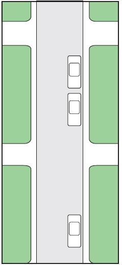
9 Subdivision - Location, Layout & Siting 9

10 Subdivision - Location, Layout & Siting 10

11 Defendable Space & Construction Requirements - Mandatory Standards BF6.1, BF7.1 &
12 Defendable space and construction requirements Must be calculated in accordance with Table 1 or 2 of Clause to limit radiant heat and ember attack 12
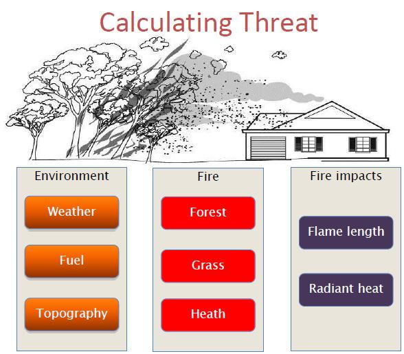
13 AS Model In essence the calculation of radiant heat under AS 3959 methodology determine: How a fire is likely to move across the landscape The flame length, and How this flame will emit radiation and how that energy will be received by a structure (Radiant heat exposure)
14
15 AS Model
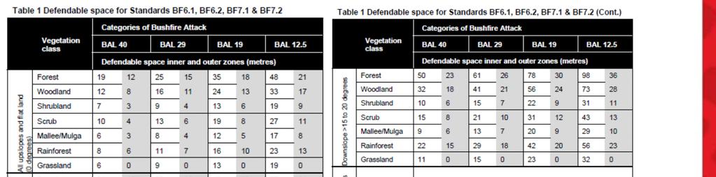
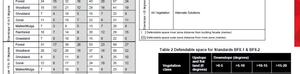
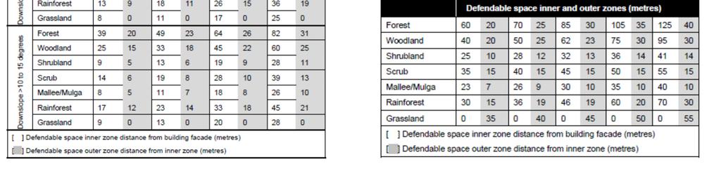
16 Defendable Space Table 1 & 2 of Clause 52.47


17 Bushfire Site Assessment (Example - Single Site)
 Table")

18 Bushfire Site Assessment (Example - Subdivision) Table Vegetation, Slope, Construction Requirement & Defendable Space
19 Subdivision Defendable space location 19
20 Subdivision - Defendable space location 20
21 Subdivision - Defendable space location 21
22 Subdivision communal (open space) areas 22
23 Subdivision communal (open space) areas Subdivisions that create public open space or communal land Management agreement to implement defendable space - Agreement to be provided from responsible party - Outline defendable space prescriptions - To be applied in perpetuity - Section 173 agreement where land is privately owned Management agreement to be implemented prior to Statement of Compliance 23
24 Standard BF1 & BF2 additional matters BF 1 subdivisions-defendable space should adequately reflect the use of the land - E.g. Rural land BAL 12.5 defendable space - Siting constraints, landscape risk and surrounding density of development may allow for less defendable space than 12.5 May consider a section 173 agreement for all subdivisions (i.e. including rural land) for the purpose of dwelling permit exemption, if appropriate. Defendable space to be implemented prior to Statement of Compliance 24
25 Subdivision containing Existing Development Subdivision should not create a lot that would not get a future permit to develop the land in line with its zoning Existing buildings BAL defendable space commensurate to existing construction standard Where BAL 12.5 defendable space is not being achieved should demonstrate subdivision will not increase the risk Defendable space on the allotment rather than relying on a 173 Agreement 25
 and cannot achieve BAL 40.")
26 Activity: Subdivision design Proposal: Subdivision. Some lots are at significant fire risk (possible flame contact) and cannot achieve BAL 40. Residential 1 (adjoining PUZ bushland reserve to the south). Overlays: SLO, BMO, DPO, ESO (Part). Subject land 26

27 Activity: Existing subdivision pattern Bushland reserve (Woodland) 27
28 Activity: Existing characteristics Subject land located adjacent to other residential estates (North, East, and West). Predominately large lots designed for single dwellings. Southern most lots exposed to abutting bushland reserve (significant fire risk possible flame contact). Lack of connectivity and circulation to the south (poor emergency access). 28
29 Activity: Subdivision design Some lots are at significant fire risk (possible flame contact). If we had our time again, what subdivision design changes could be made to achieve BAL 19? 29
30 Activity: Outcome of design review Southern-most lots exposed to bushland reserve (significant fire risk possible flame contact). Remainder of subdivision has a reduced fire risk. Full re-design not required. Re-design should consider the risks posed to southern lots with a view to redesigning these lots. 30
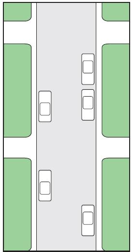
31 Activity: Outcome Establishing the main road network BAL 19 defendable space (37 metres) identified to assist in restructuring the southern perimeter road network. Main and secondary road network identified. Majority of road network to remain unchanged. 31
32 Activity: Outcome Fire Access Tracks Fire Access Tracks added to improve emergency vehicle access adjacent to fire risk. 32

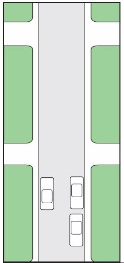
33 Activity: Outcome Perimeter roads Cul-de-sacs adjacent to bushland reserve re-considered. Perimeter roads introduced adjacent to fire risk: - Improved circulation for residents and emergency vehicles. - Provides a buffer between residential lots and major fire risk. 33
34 Activity: Outcome Lot re-design Lots adjacent to fire risk reduced, re-designed, and re-orientated so as to achieve defendable space requirements. Building envelopes located outside of 37 metre defendable space distance to achieve BAL 19. Building and population density increased away from fire risk. - Additional lots created. 34
35 Activity: Comparison 35
36 Key messages Identifying the bushfire risk and defendable space requirements up front is critical. In this instance, a response requiring re-design of whole subdivision was not required. Small design changes led to significant reduction of bushfire risk through: Minor Lot reconfiguration (predominately along the southern boundary), Fire Access Tracks, Perimeter Road. Minor increase in road space / easements. Major benefits: Provisions facilitated the development of a potentially stuck site. No net loss of dwellings. No reliance on reaching land management agreement on adjoining land. Looking north on neighbouring 2 land 1 36


37 CFA REQUIREMENTS To guide assessment of subdivisions, CFA has published requirements Residential subdivisions must be designed and located to provide ready access for fire trucks and water supply
38 CFA REQUIREMENTS Pretty simple really Fire trucks need water for firefighting Fire trucks need to access the water source and the residence The response to a fire is time critical, delays must be avoided. Firefighters must be able to access equipment on their vehicle efficiently and effectively
39 CFA REQUIREMENTS INAPPROPRIATELY DESIGNED AND SITED SUBDIVISIONS RISKS Emergency vehicles can not access incident Insufficient water supply to adequately fight fire and provide protection for fire fighters

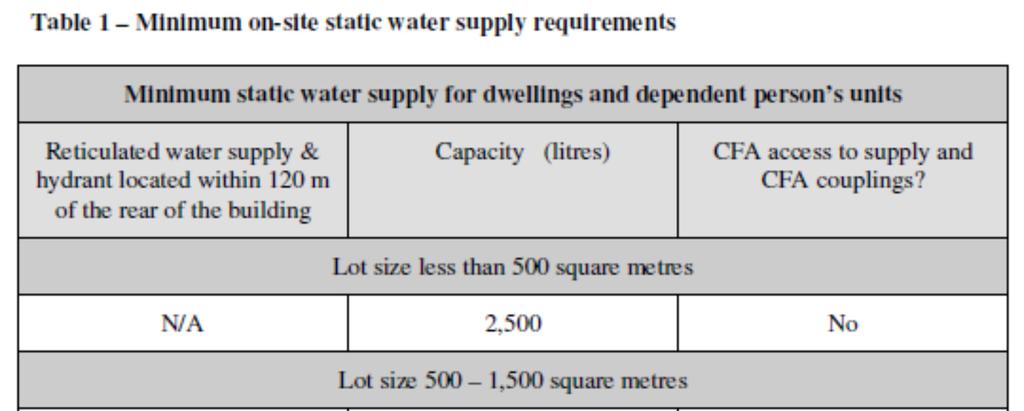
40 WATER SUPPLY REQUIREMENTS
41 Water Supply Requirements

42 WATER SUPPLY REQUIREMENTS Hydrant Location A + B = 120m Maximum 200m A B < 60m

43

44 ACCESS REQUIREMENTS 3.2m 8.2m 3.1m Mirror to mirror

45 ACCESS REQUIREMENTS 3.9m 11.8m
46 ACCESS REQUIREMENTS 7m- 7.5m 5.5m In between
47 ACCESS REQUIREMENTS:
48 ACCESS REQUIREMENTS


49 CREATING A SAFER COMMUNITY For more information visit
PROVIDENCE (BOLLARD BULRUSH SOUTH) LOCAL DEVELOPMENT PLAN. 2263Rep146E
 LOCAL DEVELOPMENT PLAN. 2263Rep146E") 1 PROVIDENCE (BOLLARD BULRUSH SOUTH) Prepared by: PO Box 796 Subiaco WA 6904 t: 9382 1233 f: 9382 1127 www.cleplan.com.au October 2013 This Local Development Plan has been approved by Council under the
1 PROVIDENCE (BOLLARD BULRUSH SOUTH) Prepared by: PO Box 796 Subiaco WA 6904 t: 9382 1233 f: 9382 1127 www.cleplan.com.au October 2013 This Local Development Plan has been approved by Council under the
Division 5 Residential Low Density Zone: Assessment Criteria and Assessment Tables
 Division 5 Residential Low Density Zone: Assessment Criteria and Assessment Tables 4.5.1 Residential Low Density Zone The provisions in this division relate to the Residential Low Density Zone as follows
TOWN PLANNING SCHEME NO. 3
 City of Cockburn TOWN PLANNING SCHEME NO. 3 AMENDMENT NO. 92 April 2012 PLANNING AND DEVELOPMENT ACT, 2005 RESOLUTION TO AMEND A TOWN PLANNING SCHEME CITY OF COCKBURN TOWN PLANNING SCHEME NO 3 AMENDMENT
Division 4 Large Lot Residential Zone: Assessment Criteria and Assessment Tables
 Division 4 Large Lot Residential Zone: Assessment Criteria and Assessment Tables 4.4.1 Large Lot Residential Zone The provisions in this division relate to the Large Lot Residential Zone as follows overall
32.08 GENERAL RESIDENTIAL ZONE. Shown on the planning scheme map as GRZ, R1Z, R2Z or R3Z with a number (if shown). Purpose
. Purpose") 32.08 GENERAL RESIDENTIAL ZONE Shown on the planning scheme map as GRZ, R1Z, R2Z or R3Z with a number (if shown). Purpose To implement the State Planning Policy Framework and the Local Planning Policy
32.08 GENERAL RESIDENTIAL ZONE Shown on the planning scheme map as GRZ, R1Z, R2Z or R3Z with a number (if shown). Purpose To implement the State Planning Policy Framework and the Local Planning Policy
Division 16 Bundamba Racecourse Stables Area Zone: Assessment Criteria and Assessment Tables
 Division 16 Bundamba Racecourse Stables Area Zone: Assessment Criteria and Assessment Tables 4.16.1 Bundamba Racecourse Stables Area Zone The provisions in this division relate to the Bundamba Racecourse
Division 6 Residential Medium Density Zone: Assessment Criteria and Assessment Tables
 Division 6 Residential Medium Density Zone: Assessment Criteria and Assessment Tables 4.6.1 Residential Medium Density Zone The provisions in this division relate to the Residential Medium Density Zone
CHAPTER34 PRUD - PLANNED RESIDENTIAL UNIT DEVELOPMENT
 CHAPTER34 PRUD - PLANNED RESIDENTIAL UNIT DEVELOPMENT 17-34-1 17-34-2 17-34-3 17-34-4 17-34-5 17-34-6 17-34-7 17-34-8 17-34-9 Purpose Planned Residential Unit Development Defined Planned Residential Unit
Development Variance Permit
 City of Surrey PLANNING & DEVELOPMENT REPORT 7906-0382-00 Development Variance Permit Proposal: Development Variance Permit to vary the minimum lot depth and the minimum front yard and rear yard setbacks
610 LAND DIVISIONS AND PROPERTY LINE ADJUSTMENTS OUTSIDE A UGB
 ARTICLE VI: LAND DIVISIONS AND PROPERTY LINE ADJUSTMENTS VI-21 610 LAND DIVISIONS AND PROPERTY LINE ADJUSTMENTS OUTSIDE A UGB 610-1 Property Line Adjustments (Property Line Relocation) A property line
ANNEXURE A. (Lots created within 276 & 280 Hale Road, Wattle Grove)
") ANNEXURE A (Lots created within 276 & 280 Hale Road, Wattle Grove) 1. DEFINITIONS 1.1 In this Contract, unless a contrary intention appears: a. Land means the land cross hatched and attached as Annexure
ANNEXURE A (Lots created within 276 & 280 Hale Road, Wattle Grove) 1. DEFINITIONS 1.1 In this Contract, unless a contrary intention appears: a. Land means the land cross hatched and attached as Annexure
METHODOLOGY GUIDE VALUING LANDS IN TRANSITION IN ONTARIO. Valuation Date: January 1, 2016
 METHODOLOGY GUIDE VALUING LANDS IN TRANSITION IN ONTARIO Valuation Date: January 1, 2016 August 2017 August 22, 2017 The Municipal Property Assessment Corporation (MPAC) is responsible for accurately assessing
Chapter 100 Planned Unit Development in Corvallis Urban Fringe
 100.100 Scope and Purpose. Chapter 100 Planned Unit Development in Corvallis Urban Fringe (1) All applications for land divisions in the Urban Residential (UR) and Flood Plain Agriculture (FPA) zones within
Zoning Code Amendments Completed and Proposed. November 2009 COMPLETED CODE AMENDMENTS. Parking Regulations Effective Sept 28, 2009 Ordinance No.
 Zoning Code Amendments Completed and Proposed COMPLETED CODE AMENDMENTS Amendment/Issue Parking Regulations Effective Sept 28, 2009 Ordinance No. 1454 Residential Density in Planned Developments Effective
Section Three, Part 9 - Subdivision
 PART 9 SUBDIVISION SUBDIVISION AND DEVELOPMENT OF LAND 9.1 INTRODUCTION This part of the District Plan sets out the provisions in respect of the subdivision and development of land in the urban part of
B. Subarea Provisions, including the Design Elements and Area of Special Concern and Potential Park/Open Space/Recreation Requirements;
 ARTICLE III: LAND USE DISTRICTS III-1 300 INTRODUCTION Article III of the Washington County Community Development Code consists of the primary and overlay districts which apply to the unincorporated areas
Date: February 15 th, Based on the analysis contained below, Development Services staff recommends:
 THE CORPORATION OF THE TOWN OF GRAVENHURST To: Committee of Adjustment From: Kris Orsan, GIS/Planning Technician Subject: A/30/2018/GR; ZIVE, Dorothy 1029 Road 2900 (Lake Muskoka) RECOMMENDATIONS Based
M-43 CORRIDOR OVERLAY ZONE
 ARTICLE 26.00 M-43 CORRIDOR OVERLAY ZONE Section 26.01 Findings A primary function of the M-43 state highway is to move traffic through the Township and to points beyond. As the primary east-west arterial
CASTLES OF CALEDON URBAN DESIGN REPORT
 CASTLES OF CALEDON URBAN DESIGN REPORT PROPOSED RESIDENTIAL DEVELOPMENT CALEDON, ONTARIO 10 JULY, 2015 TABLE CONTENTS: 1.0 DEVELOPMENT 4.0 CONCLUSION 1.1 Introduction 1.2 Castles of Caledon- Urban Design
9.3.6 Dwelling house code
 9.3.6 Dwelling house code 9.3.6.1 Application (1) This code applies to accepted development assessable development identified as requiring assessment against the Dwelling house 3 code by the tables of
Town of Falmouth s Four Step Design Process for Subdivisions in the Resource Conservation Zoning Overlay District
 Town of Falmouth s Four Step Design Process for Subdivisions in the Resource Conservation Zoning Overlay District All subdivisions shall be designed in accordance with the following four-step process.
ARTICLE 23 CONDOMINIUM STANDARDS
 ARTICLE 23 CONDOMINIUM STANDARDS Section 23.01 Intent. The intent of this Article is to provide regulatory standards for condominiums and site condominiums similar to those required for projects developed
32.07 RESIDENTIAL GROWTH ZONE. Shown on the planning scheme map as RGZ with a number (if shown). Purpose
. Purpose") 32.07 RESIDENTIAL GROWTH ZONE Shown on the planning scheme map as RGZ with a number (if shown). Purpose To implement the State Planning Policy Framework and the Local Planning Policy Framework, including
32.07 RESIDENTIAL GROWTH ZONE Shown on the planning scheme map as RGZ with a number (if shown). Purpose To implement the State Planning Policy Framework and the Local Planning Policy Framework, including
Division 8 General Urban (T4) Zone: Assessment Criteria and Assessment Tables
 Zone: Assessment Criteria and Assessment Tables") Division 8 General Urban (T4) Zone: Assessment Criteria and Assessment Tables 15.8.1 General Urban (T4) Zone The provisions in this division relate to the General Urban (T4) Zone as follows overall outcomes
Division 8 General Urban (T4) Zone: Assessment Criteria and Assessment Tables 15.8.1 General Urban (T4) Zone The provisions in this division relate to the General Urban (T4) Zone as follows overall outcomes
Chapter Plat Design (LMC)
") Chapter 18.14 Plat Design (LMC) Sections: 18.14.010 Lot width 18.14.020 Right-of-way requirements 18.14.030 Pipe stem lots 18.14.040 Division resulting in minimum lot sizes 18.14.050 Flood prone and bad
Chapter 18.14 Plat Design (LMC) Sections: 18.14.010 Lot width 18.14.020 Right-of-way requirements 18.14.030 Pipe stem lots 18.14.040 Division resulting in minimum lot sizes 18.14.050 Flood prone and bad
Community Development Department Planning Division 1600 First Street + P.O. Box 660 Napa, CA Napa (707)
") Community Development Department Planning Division 1600 First Street + P.O. Box 660 Napa, CA 94559-0660 Napa (707) 257-9530 PLANNING COMMISSION STAFF REPORT JUNE 16, 2016 AGENDA ITEM # 6.B. 16-0056-EXT;
Community Development Department Planning Division 1600 First Street + P.O. Box 660 Napa, CA 94559-0660 Napa (707) 257-9530 PLANNING COMMISSION STAFF REPORT JUNE 16, 2016 AGENDA ITEM # 6.B. 16-0056-EXT;
Appendix 5 - Track Changed Ordinance
 SCHEDULE 1 TO THE URBAN GROWTH ZONE Shown on the planning scheme map as UGZ1 1.0 The Plan Shepparton North East Plan 1 shows the future urban structure proposed in the Shepparton North East Precinct Structure
THE COUNTY BOARD OF SUPERVISORS OF THE COUNTY OF DOUGLAS DOES ORDAIN AS FOLLOWS:
 8.1 SUBDIVISION CONTROL ORDINANCE THE COUNTY BOARD OF SUPERVISORS OF THE COUNTY OF DOUGLAS DOES ORDAIN AS FOLLOWS: SECTION I. GENERAL INTERPRETATION This ordinance shall not repeal, impair or modify private
32.07 RESIDENTIAL GROWTH ZONE
 32.07 RESIDENTIAL GROWTH ZONE 29/08/2017 VC139 Shown on the planning scheme map as RGZ with a number (if shown). Purpose To implement the State Planning Policy Framework and the Local Planning Policy Framework,
Flinders Avenue, Lara Planning Scheme Amendment Combined Application for Rezoning and Multi-Lot Subdivision Reference : Decembe
 143-179 Flinders Avenue, Lara Planning Scheme Amendment Combined Application for Rezoning and Multi-Lot Subdivision Reference: 14134-03 TGM Group Geelong Melbourne Ballarat 1/27-31 Myers Street (PO Box
CHAPTER 3 PRELIMINARY PLAT
 10-3-1 10-3-3 SECTION: CHAPTER 3 PRELIMINARY PLAT 10-3-1: Consultation 10-3-2: Filing 10-3-3: Requirements 10-3-4: Approval 10-3-5: Time Limitation 10-3-6: Grading Limitation 10-3-1: CONSULTATION: Each
Resource consent application/ Fast-Track resource consent
 Resource consent application/ Fast-Track resource consent Under Sections 87AAC, 88, Resource Management Act 1991 Notes for the applicant Use this form to apply for resource consent. It gives us your contact
SECTION 10.8 PUD (PLANNED UNIT DEVELOPMENT) OVERLAY ZONE
 OVERLAY ZONE") Article X Zones 10-22 SECTION 10.8 PUD (PLANNED UNIT DEVELOPMENT) OVERLAY ZONE A. PURPOSE: The purposes of the Planned Unit Development (PUD) Overlay Zone are to: promote flexibility in design and permit
Article X Zones 10-22 SECTION 10.8 PUD (PLANNED UNIT DEVELOPMENT) OVERLAY ZONE A. PURPOSE: The purposes of the Planned Unit Development (PUD) Overlay Zone are to: promote flexibility in design and permit
PLANNING SUBMISSION & CLAUSE 56 ASSESSMENT RESIDENTIAL SUBDIVISION OF LAND 1525 POUND ROAD, CLYDE NORTH (LOT 2 PS F, SIENNA PARK ESTATE)
") PLANNING SUBMISSION & CLAUSE 56 ASSESSMENT RESIDENTIAL SUBDIVISION OF LAND 1525 POUND ROAD, CLYDE NORTH (LOT 2 PS 327975F, SIENNA PARK ESTATE) DFC (PROJECT MANAGEMENT) PTY LTD (A DENNIS FAMILY CORPORATION
PLANNING SUBMISSION & CLAUSE 56 ASSESSMENT RESIDENTIAL SUBDIVISION OF LAND 1525 POUND ROAD, CLYDE NORTH (LOT 2 PS 327975F, SIENNA PARK ESTATE) DFC (PROJECT MANAGEMENT) PTY LTD (A DENNIS FAMILY CORPORATION
Chapter SPECIAL USE ZONING DISTRICTS
 Chapter 20.20 Sections: 20.20.010 Urban Transition (U-T) Zoning District 20.20.020 Planned Development (P-D) Zoning Districts 20.20.010 Urban Transition (U-T) Zoning District A. Purpose. The purpose of
Multi-unit residential uses code
 9.3.11 Multi-unit residential uses code 9.3.11.1 Application (1) This code applies to assessable development identified as requiring assessment against the Multi-unit residential uses code by the tables
Min. Lot Frontage (Ft.) 1. Min. Front Yard (Ft.) Min. Rear Yard (Ft.) R , R , R ,
 1. Min. Front Yard (Ft.) Min. Rear Yard (Ft.) R , R , R ,") SECTION 11 - DIMENSIONAL REQUIREMENTS A. The following standards shall be required for single family dwellings and associated accessory uses and structures within Residence s, except as expressly permitted
SECTION 11 - DIMENSIONAL REQUIREMENTS A. The following standards shall be required for single family dwellings and associated accessory uses and structures within Residence s, except as expressly permitted
9.3.5 Dual occupancy code
 9.3.5 Dual occupancy code 9.3.5.1 Application (1) This code applies to accepted development and assessable development identified as requiring assessment against the Dual occupancy 1 code by the tables
There is no Communal Open Space (COS) requirement for condominium developments.
 requirement for condominium developments.") 6 CONDOMINIUM FLATS CONDOMINIUM FLATS 1 Unlike flat developments, condominium housing requires a larger land area. Condominium flats, too, form the bulk of medium to high density housing in Singapore.
6 CONDOMINIUM FLATS CONDOMINIUM FLATS 1 Unlike flat developments, condominium housing requires a larger land area. Condominium flats, too, form the bulk of medium to high density housing in Singapore.
BUSHFIRE MANAGEMENT PLAN
 T: 1300 797 607 E: admin@ruic.net.au BUSHFIRE MANAGEMENT PLAN Site: Byford on the Scarp Stage 7 Version: 1.3 Job: 3042 RUIC PERTH MARGARET RIVER BUSSELTON Bushfire Management Plan RUIC Fire is a trading
Draft Zoning Changes for the 2nd Planning Board Public Hearing, January 22, 2018.
 Draft Zoning Changes for the 2nd Planning Board Public Hearing, January 22, 2018. No changes were made at the 1st Public Hearing. Proposed wording for the 1 st Public Hearing in red, eliminated text in
Resource Consent Application Form
 Resource Consent Application Form Section 88 of the Resource Management Act 1991. This form provides us with your contact information and details about your proposal. Please print clearly and complete
RESIDENTIAL AND RECREATIONAL
 Energy, Mines & Resources Land Management Branch 320-300 Main Street Whitehorse, Yukon Y1A 2B5 667-5215 Fax 667-3214 www.emr.gov.yk.ca RESIDENTIAL AND RECREATIONAL Lot Enlargement Policy OBJECTIVE To facilitate
Such further or other relief that addresses the issues raised in this appeal point
 Context of the appeal: PD & KJ Sieling consider that: 1. The PDP fails to adequately address Whitianga zoning issues in a pragmatic manner by not allowing for sensible growth of the township and its immediate
Chapter Planned Residential Development Overlay
 Chapter 19.29 Planned Residential Development Overlay Sections 010 Purpose 020 Scope 030 Definitions 030 Minimum Size 040 Allowable Uses 050 Minimum Development Standards 060 Density Bonus 070 Open Space
Community Development Department 333 Broadalbin Street SW, P.O. Box 490 Albany, OR 97321
 SUMMARY Community Development Department 333 Broadalbin Street SW, P.O. Box 490 Albany, OR 97321 STAFF REPORT Application for Tentative Partition Plat Review Planning File PA-06-17 Phone: 541-917-7550
I Harris. Melbourne. John Quirk, Member. Merits Review of Refusal
 VICTORIAN CIVIL AND ADMINISTRATIVE TRIBUNAL ADMINISTRATIVE DIVISION PLANNING AND ENVIRONMENT LIST VCAT REFERENCE NO. P382/2005 PERMIT APPLICATION NO. YR-2004/1272 CATCHWORDS 4 lot subdivision of large
Condition. The gross floor area of all buildings must not exceed 250 square metres.
 32.03 LOW DENSITY RESIDENTIAL ZONE 23/09/2011 Shown on the planning scheme map as LDRZ with a number (if shown). Purpose To implement the State Planning Policy Framework and the Local Planning Policy Framework,
Woldingham Association
 Regulation 18 Sites Consultation Representation Representation on the 2016 Regulation 18 Sites Consultation for the Tandridge Local Plan Part 1 from the Submitted to Tandridge District Council on 20 Dec
TENTATIVE PARCEL MAP TIME EXTENSION
 EL DORADO COUNTY DEVELOPMENT SERVICES ZONING ADMINISTRATOR STAFF REPORT Agenda of: October 15, 2008 Item No.: Staff: 4.a. Mel Pabalinas TENTATIVE PARCEL MAP TIME EXTENSION APPLICATION FILE NO.: APPLICANT:
New Victorian Residential Zones 2013
 Clause 1 Planning Page 1 of 35 Clause 1 is a town planning consultancy. We specialise in assisting property developers, architects and building designers meet the increasingly complex requirements of State
fact sheet INFORMATION REGARDING 1(A) RURAL LAND IN NORTH ARM COVE, PINDIMAR, BUNDABAH, CARRINGTON AND HAMILTON VILLAGE LOCALITIES
 RURAL LAND IN NORTH ARM COVE, PINDIMAR, BUNDABAH, CARRINGTON AND HAMILTON VILLAGE LOCALITIES") fact sheet Breese Parade Forster PO Box 450 Forster NSW 2428 phone 02 6591 7222 fax 02 6591 7200 email council@greatlakes.nsw.gov.au website www.greatlakes.nsw.gov.au INFORMATION REGARDING 1(A) RURAL LAND
fact sheet Breese Parade Forster PO Box 450 Forster NSW 2428 phone 02 6591 7222 fax 02 6591 7200 email council@greatlakes.nsw.gov.au website www.greatlakes.nsw.gov.au INFORMATION REGARDING 1(A) RURAL LAND
Clearcreek Township Zoning Staff Report Soraya Farms Section 6 Stage 3 Review Page 1 of 8
 Staff Report: Completed by Jeff Palmer Director of Planning & Zoning Report Date: September 10, 2018 Meeting Date: October 1, 2018 Applicant: Shery Oakes, agent for Soraya Farms Requested Action: Soraya
DRAFT PROPOSED CHAPTER 21 SPECIFIC PURPOSE - FLAT LAND RECOVERY ZONE
 DRAFT PROPOSED CHAPTER 21 SPECIFIC PURPOSE - FLAT LAND RECOVERY ZONE Note: The Specific Purpose (Flat Land Recovery) Zone is a "holding" zone that will be subject to a later plan change to confirm the
INDIAN RIVER COUNTY, FLORIDA. The Honorable Members of the Planning and Zoning Commission DEPARTMENT HEAD CONCURRENCE
 Public Hearing Legislative INDIAN RIVER COUNTY, FLORIDA M E M O R A N D U M TO: The Honorable Members of the Planning and Zoning Commission DEPARTMENT HEAD CONCURRENCE Robert M. Keating, AICP; Community
Prepared By: 03/20/2013. feet EFU RR-5. Zoning. Taxlots. Subject UR-1. Information is deemed reliable but not guaranteed. RR-5
 Prepared By: 03/20/2013 Ü 0 260 feet EFU RR-5 Zoning Taxlots UR-1 Subject Terri Dr David Ln RR-5 Information is deemed reliable but not guaranteed. CHAPTER 5. ZONE DISTRICTS 5.1 GENERAL PROVISIONS... 1
8.5.1 R1, Single Detached Residential District
 8.5.1 R1, Single Detached Residential District The purpose of this district is to provide for residential development in the form of single detached dwellings. Dwelling, Single Detached Home Business,
LOCATION: LUC AND UNDERLYING ZONING: OCP DESIGNATION:
 City of Surrey PLANNING & DEVELOPMENT REPORT File: 7916-0404-00 Planning Report Date: October 24, 2016 PROPOSAL: Terminate Land Use Contract No. 320 to permit the existing underlying Zone to come into
Dwelling house guide
 Dwelling house guide Contents 1.0 Introduction... 1 2.0 What is a dwelling house?... 1 3.0 What building assessment provisions apply to dwelling houses?... 1 4.0 What category of development and category
a. provide for the continuation of collector streets and thoroughfare streets between adjacent subdivisions;
 Section 7.07. Intent The requirements of this Section are intended to provide for the orderly growth of the Town of Holly Springs and its extra-territorial jurisdiction by establishing guidelines for:
REPORT OF THE PLANNING AND DEVELOPMENT DEPARTMENT FOR APPLICATION FOR REZONING ORDINANCE TO PLANNED UNIT DEVELOPMENT SEPTEMBER 22, 2016
 BEL REPORT OF THE PLANNING AND DEVELOPMENT DEPARTMENT FOR APPLICATION FOR REZONING ORDINANCE 2016-576 TO PLANNED UNIT DEVELOPMENT SEPTEMBER 22, 2016 The Planning and Development Department hereby forwards
TENTATIVE PARCEL MAP APPLICATION GUIDE TENTATIVE PARCEL MAP APPLICATION REQUIREMENTS
 TENTATIVE PARCEL MAP APPLICATION GUIDE SISKIYOU COUNTY PLANNING DIVISION 806 South Main Street, Yreka CA 96097 Phone: (530) 841-2100 / Fax: (530) 841-4076 TENTATIVE PARCEL MAP APPLICATION REQUIREMENTS
LAND USE AMENDMENT SPRINGBANK HILL (WARD 6) ELMONT DRIVE SW AND 69 STREET SW BYLAW 114D2017
 ELMONT DRIVE SW AND 69 STREET SW BYLAW 114D2017") Page 1 of 8 EXECUTIVE SUMMARY This land use amendment application proposes to redesignate and subdivide 1.15 hectares of land located within the southwest community of East Springbank to accommodate 17
Page 1 of 8 EXECUTIVE SUMMARY This land use amendment application proposes to redesignate and subdivide 1.15 hectares of land located within the southwest community of East Springbank to accommodate 17
Explanation The policies ensure that land is suitable for subdivision and will not increase risks to people, the environment and property.
 23 Subdivision 23.1 Purpose a) Subdivision is essentially the process of dividing a parcel of land or a building into one or more further parcels, or changing an existing boundary location. Subdivision
SCHEDULE 12 TO THE URBAN GROWTH ZONE. Shown on the planning scheme map as UGZ12. Kororoit Precinct Structure Plan
 SCHEDULE 12 TO THE URBAN GROWTH ZONE Shown on the planning scheme map as UGZ12. Kororoit Precinct Structure Plan 1.0 The plan Map 1 below shows the future urban structure proposed in the Kororoit Precinct
1.0 REQUEST. SANTA BARBARA COUNTY ZONING ADMINISTRATOR Coastal Zone Staff Report for Vincent New Single-Family Dwelling & Septic System
 SANTA BARBARA COUNTY ZONING ADMINISTRATOR Coastal Zone Staff Report for Vincent New Single-Family Dwelling & Septic System Hearing Date: February 26, 2007 Supervisorial District: First Staff Report Date:
Requirements for accepted development and assessment benchmarks for assessable development
 9.3.10 Small Lot Housing Design Code 9.3.10.1 Application (1) This code applies to development identified as requiring assessment against the Small Lot Housing Design Code by the categories of development
AS 3959 Bushfire Attack Level (BAL) Compliance Report Stage 6 Ariella Estate, Brabham
 Compliance Report Stage 6 Ariella Estate, Brabham") To: Preston O'Keefe Date: 22 August 2018 Company: Cedar Woods Properties Limited Email: Preston.OKeefe@cedarwoods.com.au Project No: CED18426.01 Inquiries: Zac Cockerill Stage 6 Ariella Estate, Brabham
To: Preston O'Keefe Date: 22 August 2018 Company: Cedar Woods Properties Limited Email: Preston.OKeefe@cedarwoods.com.au Project No: CED18426.01 Inquiries: Zac Cockerill Stage 6 Ariella Estate, Brabham
GUIDE TO SUBDIVISION & LAND DEVELOPMENT
 GUIDE TO SUBDIVISION & LAND DEVELOPMENT The Fraser Thomas Difference: Fraser Thomas Ltd is an engineering and surveying consulting firm based in Highbrook, and has been providing; Surveying, Engineering,
Falls Church. Two Mixed-Use Ordinances
 Falls Church Helen Reinecke-Wilt, AICP Principal Planner 1 Two Mixed-Use Ordinances 1999 Mixed-Use Redevelopment Ordinance (By-right offers maximum predicatibility) 2002/03 Special Exception Ordinance
Parkland Dedication By-Law User Guide
 Parkland Dedication By-Law User Guide City of Kingston Recreation & Leisure Services August 2017 Table of Contents Purpose of By-Law... 3 How are parkland dedication requirements satisfied?... 3 What is
FINAL DRAFT 12/1/16, Rev. to 7/18/17
 FINAL DRAFT 12/1/16, Rev. to 7/18/17 (As Adopted 8/8/17 Effective 9/1/17) SHELTON PLANNING AND ZONING COMMISSION Proposed Amendments to Zoning Regulations I. Amend Section 23 PERMITTED USES by inserting
ARTICLE VI. SUBDIVISION STANDARDS, PUBLIC
 ARTICLE VI. SUBDIVISION STANDARDS, PUBLIC IMPROVEMENTS, AND DESIGN REQUIREMENTS ARTICLE VI. SUBDIVISION STANDARDS, PUBLIC IMPROVEMENTS, AND DESIGN REQUIREMENTS DIVISION 1. GENERAL PROVISIONS Sec. 21-6100.
Plat Alteration request of Barkley North LLC re 3400 Sussex Drive (aka Village on the Green Division #5 Tract B) 08/26/2015
 08/26/2015") Hearing Examiner Summary and Decision Hearing Examiner No. Planning No. Incident No. Filing Date City Contact Hearing Date Description Decision Date Decision Summary HE-15-PL-022 SUB2015-00019 06/22/2015
Hearing Examiner Summary and Decision Hearing Examiner No. Planning No. Incident No. Filing Date City Contact Hearing Date Description Decision Date Decision Summary HE-15-PL-022 SUB2015-00019 06/22/2015
H5. Residential Mixed Housing Urban Zone
 H5. Residential Mixed Housing Urban Zone [ENV-2016-AKL-000197: Robert Adams] Addition sought H5.1. Zone description The Residential Mixed Housing Urban Zone is a reasonably high-intensity zone enabling
Guide to Combined Preliminary and Final Plats
 Guide to Combined Preliminary and Final Plats Introduction The Douglas County is committed to providing open, transparent application processes to the public. This Guide is provided to assist anyone interested
TOWN OF PALM BEACH. Utility Undergrounding Assessment Methodology Update. June 2, 2017
 TOWN OF PALM BEACH Utility Undergrounding Assessment Methodology Update June 2, 2017 TABLE OF CONTENTS 1. EXECUTIVE SUMMARY... 4 BACKGROUND... 4 2. PROPOSED PUBLIC FACILITIES... 5 FACILITIES... 5 3. BENEFIT
City of Surrey PLANNING & DEVELOPMENT REPORT File:
 City of Surrey PLANNING & DEVELOPMENT REPORT PROPOSAL: Planning Report Date: February 9, 2009 Development Variance Permit in order to permit a reduced lot frontage to allow subdivision into two half-acre
Medical Marijuana Special Exception Use Information
 Medical Marijuana Special Exception Use Information The Special Exception Use information below is a modified version of the Unified Development Code. It clarifies the current section 5:104 Special Exceptions
AN ORDINANCE AMENDING THE CITY ZONING ORDINANCE AND THE OFFICIAL CODE OF THE CITY OF CLARKSVILLE RELATIVE TO CLUSTER OPTION DEVELOPMENTS
 ORDINANCE 74-2012-13 AN ORDINANCE AMENDING THE CITY ZONING ORDINANCE AND THE OFFICIAL CODE OF THE CITY OF CLARKSVILLE RELATIVE TO CLUSTER OPTION DEVELOPMENTS BE IT ORDAINED BY THE CITY COUNCIL OF THE CITY
REPORT OF THE PLANNING AND DEVELOPMENT DEPARTMENT FOR APPLICATION FOR REZONING ORDINANCE TO PLANNED UNIT DEVELOPMENT MAY 18, 2017
 BEL REPORT OF THE PLANNING AND DEVELOPMENT DEPARTMENT FOR APPLICATION FOR REZONING ORDINANCE 2016-805 TO PLANNED UNIT DEVELOPMENT MAY 18, 2017 The Planning and Development Department hereby forwards to
Guide to Subdivision and Land Development
 Guide to Subdivision and Land Development Fraser Thomas Ltd......is an engineering and surveying consulting firm based in Highbrook which has provided Surveying, Engineering, Planning and Resource Management
CHAPTER 25 REVIEW AND APPROVAL OF SITE CONDOMINIUM AND CONDOMINIUM PROJECTS
 CHAPTER 25 REVIEW AND APPROVAL OF SITE CONDOMINIUM AND CONDOMINIUM PROJECTS Section 25.1. Purpose and Scope. 1. Tracts of land that are developed and sold as site condominium developments and condominium
Guide to Minor Developments
 Guide to Minor Developments Introduction The Douglas County (DCD) is committed to providing open, transparent application processes to the public. This Guide is provided to assist anyone interested in
APPLICATION FOR SUBDIVISION APPROVAL OF A SKETCH PLAN with checklist
 Prior to filing any application for SUBDIVISION approval, the applicant shall request in writing that the zoning administrator schedule a pre-submission conference. APPLICATION TO THE PLANNING BOARD TOWN
ZONING ORDINANCE: OPEN SPACE COMMUNITY. Hamburg Township, MI
 ZONING ORDINANCE: OPEN SPACE COMMUNITY Hamburg Township, MI ARTICLE 14.00 OPEN SPACE COMMUNITY (Adopted 1/16/92) Section 14.1. Intent It is the intent of this Article to offer an alternative to traditional
Guide to Preliminary Plans
 Guide to Preliminary Plans Introduction The Douglas County is committed to providing open, transparent application processes to the public. This Guide is provided to assist anyone interested in the procedures
ARTICLE III: LAND USE DISTRICTS 304 R 9 DISTRICT
 ARTICLE III: LAND USE DISTRICTS III 23 304 R 9 DISTRICT (RESIDENTIAL 9 UNITS PER ACRE) 304 1 Intent and Purpose The R 9 District is intended to implement the policies of the Comprehensive Plan for areas
CHAPTER 14 PLANNED UNIT DEVELOPMENTS
 9-14-1 9-14-1 CHAPTER 14 PLANNED UNIT DEVELOPMENTS SECTION: 9-14-1: Purpose 9-14-2: Governing Provisions 9-14-3: Minimum Area 9-14-4: Uses Permitted 9-14-5: Common Open Space 9-14-6: Utility Requirements
THE VILLAGES MASTER PLANNED DEVELOPMENT DEVELOPMENT AGREEMENT BETWEEN CITY OF BLACK DIAMOND, WASHINGTON and BD VILLAGE PARTNERS, L.P.
 THE VILLAGES MASTER PLANNED DEVELOPMENT DEVELOPMENT AGREEMENT BETWEEN CITY OF BLACK DIAMOND, WASHINGTON and BD VILLAGE PARTNERS, L.P. A. Parties, Date, Recitals, and Mutual Consideration... 1 B. Terms...
ARTICLE 16 SUBDIVISIONS
 ARTICLE 16 SUBDIVISIONS 16.1 Subdivision Regulations 16.1-1. Purpose. The regulations for the subdivision of land set forth below are established to promote orderly growth and development; provide for
LOT LINE ADJUSTMENT APPLICATION GUIDE (BCC , ET SEQ.)
") Butte County Department of Development Services PERMIT CENTER 7 County Center Drive, Oroville, CA 95965 Planning Division Phone 530.552.3701 Fax 530.538.7785 Email dsplanning@buttecounty.net FORM NO PLG-02
Butte County Department of Development Services PERMIT CENTER 7 County Center Drive, Oroville, CA 95965 Planning Division Phone 530.552.3701 Fax 530.538.7785 Email dsplanning@buttecounty.net FORM NO PLG-02
TOTTENHAM SECONDARY PLAN
 TOTTENHAM SECONDARY PLAN AMENDMENT NO. 11 TO THE OFFICIAL PLAN OF THE TOWN OF NEW TECUMSETH The following text and schedules to the Official Plan of the Town of New Tecumseth constitute Amendment No. 11
Article Optional Method Requirements
 Article 59-6. Optional Method Requirements [DIV. 6.1. MPDU DEVELOPMENT IN RURAL RESIDENTIAL AND RESIDENTIAL ZONES Sec. 6.1.1. General Requirements... 6 2 Sec. 6.1.2. General Site and Building Type Mix...
CCC XXX Rural Neighborhood Conservation (NC)
") CCC 33.10.XXX Rural Neighborhood Conservation (NC) Purpose: Maintain low density rural residential areas and associated uses commonly found in rural areas consistent with the local character of the distinctive
CCC 33.10.XXX Rural Neighborhood Conservation (NC) Purpose: Maintain low density rural residential areas and associated uses commonly found in rural areas consistent with the local character of the distinctive
BEFORE THE LANCASTER TOWNSHIP BOARD OF SUPERVISORS BUTLER COUNTY, PENNSYLVANIA FINDINGS OF FACT, CONCLUSIONS OF LAW AND DECISION FINDINGS OF FACT
 BEFORE THE LANCASTER TOWNSHIP BOARD OF SUPERVISORS BUTLER COUNTY, PENNSYLVANIA IN RE: Conditional Use and Preliminary ) and Final Land Development Applications ) for Planned Unit Development by ) Arden
Chair and Members Planning and Economic Development Committee
 TO: FROM: Chair and Members Planning and Economic Development Committee Melissa Halford Manager of Planning DATE: June 23, 2016 SUBJECT: Amendment No. 6 to Draft Approval Subdivision File No. S2006-3 (Loon
SUBDIVISION REGULATIONS for Lawrence and the Unincorporated Areas of Douglas County, KS
 SUBDIVISION REGULATIONS for Lawrence and the Unincorporated Areas of Douglas County, KS December 19, 2006 Edition Amended: 09/11/07; 12/04/07; 03/25/08; 09/10/08 Amended: January 6, 2009 Article 8 Subdivision
PRELIMINARY SUBDIVISION PLAN APPLICATION INSTRUCTIONS
 City of Chesapeake Department of Planning Post Office Box 15225 Chesapeake, Virginia 23328-5225 (757) 382-6176 FAX (757) 382-6406 PRELIMINARY SUBDIVISION PLAN APPLICATION INSTRUCTIONS PURPOSE A preliminary
1105 SUBDIVISIONS, PARTITIONS, REPLATS, CONDOMINIUM PLATS, AND VACATIONS OF RECORDED PLATS
 1105 SUBDIVISIONS, PARTITIONS, REPLATS, CONDOMINIUM PLATS, AND VACATIONS OF RECORDED PLATS 1105.01 PURPOSE AND APPLICABILITY Section 1105 is adopted to provide standards, criteria, and procedures under