Agenda. PLANNING COMMISSION REGULAR DOCKET TUESDAY, November 10, :30 P.M. CITY COUNCIL CHAMBERS
|
|
|
- Jocelin Floyd
- 5 years ago
- Views:
Transcription
1 Agenda PLANNING COMMISSION REGULAR DOCKET TUESDAY, November 10, :30 P.M. CITY COUNCIL CHAMBERS I. PLANNING COMMISSION GATHERING -- 4:30 P.M. (Held in the NDS Conference Room) Commissioners gather to communicate with staff. (4:30-5:30 P.M.) II. REGULAR MEETING -- 5:30 P.M. A. COMMISSIONERS' REPORTS B. UNIVERSITY REPORT C. CHAIR'S REPORT D. DEPARTMENT OF NDS E. MATTERS TO BE PRESENTED BY THE PUBLIC NOT ON THE FORMAL AGENDA FOR PUBLIC HEARING F. CONSENT AGENDA (Items removed from the consent agenda will be considered at the end of the regular agenda) 1. Minutes - October 13, 2015 Pre meeting 2. Minutes - October 13, 2015 Regular meeting 4. Site Plan - Lochlyn Hill - Block 2B III. JOINT PUBLIC HEARINGS (Beginning at 6:00 P.M.) G. JOINT PUBLIC HEARINGS 1. ZT Alcoholic Beverage Production Zoning Amendments: A proposed zoning text amendment, to amend the Zoning Ordinance of the City of Charlottesville, to allow micro-wineries and micro-distilleries in certain zoning districts, pursuant to a new definition of micro-producers and to redefine a limited-scale brewery that would be permitted outside the City s industrial zones. Currently, microwineries and micro-distilleries are not listed in the zoning ordinance as permitted uses. Microbreweries, having a production capacity of less than 15,000 barrels per year, are excluded from all residential zoning districts and from the B1, ES, CH, and NCC districts, but are permitted in all other zoning districts as a general and commercial use. Currently, breweries other than microbreweries are allowed only in locations zoned for industrial uses. REGULAR MEETING (Continued) H. Entrance Corridor Review a Hydraulic Road I. FUTURE MEETING SCHEDULE Tuesday, November 24, :00 PM Work Session Capital Improvement Program Tuesday, December 8, :30 PM Pre- Meeting Tuesday, December 8, :30 PM Regular Site Plan Market Plaza Meeting Water Resources Appeal Rialto Beach PUD Minutes - September 22, 2015 Work Session Anticipated Items on Future Agendas
2 Harmony Ridge Subdivision Plat Grove Street Site Plan Persons with Disabilities may request reasonable accommodations by contacting or (434) PLEASE NOTE: THIS AGENDA IS SUBJECT TO CHANGE PRIOR TO THE MEETING. PLEASE NOTE: We are including suggested time frames on Agenda items. These times are subject to change at any time during the meeting.
3 LIST OF SITE PLANS AND SUBDIVISIONS APPROVED ADMINISTRATIVELY 10/1/2015 TO 10/31/ Preliminary Site Plans 2. Final Site Plans a. Johnson Village Phase 3 October 30, Site Plan Amendments 4. Minor Subdivision a. Boundary Line Adjustment TMP 49-5 (68 University Way) October 2, 2015
4 MINUTES PLANNING COMMISSION REGULAR MEETING Tuesday, October 13, 2015 I. PLANNING COMMISSION PRE-MEETING (Beginning at 4:30 p.m.) Location: NDS Conference Room, Charlottesville City Hall, 2nd Floor Members Present: Chairman John Santoski, Commissioners Lisa Green, Kurt Keesecker, Genevieve Keller, Jody Lahendro, Taneia Dowell, Dan Rosensweig; and; UVA representative Bill Palmer. Call to Order: the meeting was called to order by Chair Santoski at 5:00 p.m. John Santoski called the meeting to order at 5pm and provided an overview of the change of order of the agenda for this evening. Concerning the Midland application, Mr. Lahendro asked why the applicant asked for B-2 instead of R-3. Staff provided background on what is allowed in both as well as information on the surrounding zoning classifications. Ms. Dowell asked for further detail on the request for first floor residential consideration. Ms. Rainey explained the theory and provided background from the Form Base Code consultants. Adjournment: At 5:30 p.m. the Chair adjourned the meeting in order to reconvene in City Council Chambers at 5:30 to continue with the Commission s regular monthly agenda. II. ADMINISTRATIVE AGENDA (Beginning at 5:30 p.m.) Location: City Council Chambers, Charlottesville City Hall, 2nd Floor Members Present: Chairman John Santoski, Commissioners Lisa Green, Kurt Keesecker, Genevieve Keller, Jody Lahendro, Taneia Dowell, Dan Rosensweig; and; UVA representative Bill Palmer Call to Order: the meeting was called to order by Chairman Santoski at 5:30 p.m. A. COMMISSIONERS' REPORTS: Commissioner Lahendro reported he attended the Parks and Recreation Advisory Committee meeting on September 16 th. The major items discussed were implementing the master plan for Meadow Creek Valley and having the two bridges designed and constructed by next summer. This will allow us to put the trail into the Meadow Creek Valley and make the connections to Greenbrier. Secondly there was a presentation on the successful new pre-school program called Robin and Mani's All 1
5 Buddy Camp which is a therapeutic recreational camp linking high school volunteers with pre-school children with disabilities. He met with the Tree Commission on September 23 rd. Four new trees will be submitted to City Council for city recognition in the tree conservation program. The Tree Commission is working with city staff to identify certain ashes to receive the treatment to protect them against the emerald bore and the treatment should start soon. The Tree Planting committee of this commission has identified possible locations in the entry corridors to the city to receive plantings and they will finalize those recommendations with staff. Finally, the City is purchasing 40 acres across from Old Lynchburg Road for Azalea Park. Commissioner Keller reported the Thomas Jefferson Planning District Commission is in the mist of its annual budgeting process which will be going on over the next few weeks. One of the interesting projects they are working on is located in Albemarle County. It is a project that will promote bicycle connectivity to the new 5 th Street Station Development and will provide some opportunity for a connection to city neighborhoods and city roads, walks, paths and trails in the future. That is a very positive move. She said the Thomas Jefferson Planning District Commission on Water Street has a meeting space that is available for a modest fee, for non-profits and government agencies that are looking for a space for workshops, meetings and small conferences. She attended a session on behalf of the West Main Street Steering Committee that was held by City Council. It was a facilitated session and members of the committee were invited to attend. She was encouraged by that process because there was a great deal of consensus achieved by Council and weighed in by members of the committee about what would be the areas of agreement going forward on the West Main Street Streetscape project. She said that was a step in the right direction. Commissioner Dowell no report Commissioner Keesecker reported he attended the BAR meeting September 15 th and there were 13 or 14 items on the agenda. The BAR received a package of information from the Powe Studio Architect related to the Market Plaza Project, which was approved 7-1. The other project added was a mural from the Charlottesville Mural Project on the side of the Graduate Hotel facing west on the corner. He said it was an interesting design and location to animate that part of town and it was approved unanimously. The 550 East Water Street proposal that we had seen previouslyas a Special Use Permit request for additional height came to the BAR as a by right height project with fewer units and seems to be moving through the process, which was a preliminary discussion. Another project is the Atlantic on West Main Street near the Sprint building, Eloise and Oakhart Social, and two old houses that face Commerce Street behind it. It is a project that had originally taken up a broader width on West Main and is now coming back to the BAR narrower (almost immediately behind the two old homes). Commissioner Rosensweig no report Commissioner Green no report 2
6 Chairman s Report Mr. Santoski reported that the MPO Tech committee met and approved some trail connections near 5 th Street extended where the Wegmans is going into for their consideration. The idea is to tie all of the trails together into the Southwood Development. B. UNIVERSITY REPORT: Bill Palmer no report C. DEPARTMENT OF NDS: Missy Creasy, Assistant NDS Director, reported that the Planning Commission would not have an October work session. D. MATTERS TO BE PRESENTED BY THE PUBLIC NOT ON THE FORMAL AGENDA Rebecca Quinn, th Street: said she has spoken before about the public s ability to hear what goes on at public meetings and she is pleased to say, in her limited experience, watching on television from time to time, she thinks you all are doing a much better job. She wanted to note that in the work session, Commissioner Keesecker mentioned something that is in the minutes that wasn t exactly what he said. And just to keep in mind if you don t speak clearly in the microphone, then the audio, much less the video doesn t reflect what you actually say. So, I want to encourage you that you are not having conversations amongst yourselves or with staff, you are speaking to the public. Don t be shy; use your microphones, and thank you for paying attention more recently. E. CONSENT AGENDA (Items removed from the consent agenda will be considered at the end of the regular agenda) 1. Minutes - August 25, 2015 Work Session 2. Minutes - September 9, 2015 Pre meeting 3. Minutes - September 9, 2015 Regular meeting Motioned by Commissioner Rosensweig to accept the Consent Agenda, seconded by Commissioner Keesecker, motioned passes by 8-0 with the necessary corrections. Subdivision - Water Street Promenade David Jordan of Roudabush, Gale & Associates, Inc., acting as agent for Riverbend Development has submitted a subdivision application for a property at unaddressed locations on Water Street Extended. The applicant is proposing to divide the existing lot to create the 24 residential lots. This subdivision is considered major because it includes more than 6 lots and the extension of public facilities. The property is further identified on City Real Property Tax Map 57, Parcel 157A having frontage on Water Street Extended right-of-way. The site is zoned PUD (Planned Unit Development) and is approximately 2.16 acres. The applicant submitted a subdivision plan on August 26, Attached is the subdivision plan layout with engineering, landscaping and utility details. 3
7 Carrie Rainey, Urban Designer said the site plan does show the coal tower area as a green space. It was determined during the rezoning that it will be privately maintained by the homeowners association. Missy Creasy, Assistant NDS Director, said we have hopes that the road will be opened soon. She said while Riverbend could likely begin construction without the street being publicly open, it could not be granted certificates of occupancy without road access. Commissioner Lahendro moved to approve the proposed subdivision located at Tax Map 57 Parcel 157A as submitted, with the addition of the following condition: the deed of easement for the public gas easement must be completed and recorded before final plat approval, seconded by Commissioner Keller, motion passes 7-0. The meeting was paused for a 10 minute Break 2. ZM Midland Street and Randolph Avenue Rezoning - Mark Jones, acting as agent for property owner Donnie McDaniel, has submitted a petition to rezone vacant land at the intersection of Midland Street and the Randolph Avenue, right-of-way from low-density (R-1S) Residential to B-2 Commercial with proffers. Carrie Rainey, Urban Designer, said the property owner is seeking to build several new dwelling units and multifamily units could be built under the requested B-2 zoning but only one single residence could be constructed in the existing category. Randolph Avenue is a paper street that exists in city records but has never been built to city standards. Commercial activities and uses would not be appropriate for this parcel, and the applicant offered to give up the right to all business activities allowing only residential ones. Commissioner Rosensweig asked if Midland and Randolph were connected and was there an actual public right of way, and would they be able to subdivide this by right under R1S. Ms. Rainey said they wanted to divide under the existing R1S. It appears they could not because they are at approximately 10,000 square feet and would need 6,000 square feet per lot minimum in an R1S zone. Commissioner Green asked was there plans for Randolph to be constructed. Ms. Rainey said there are no plans for public construction. The applicant or anybody else are welcome to build or develop Randolph Avenue if they follow our standards of development through our standards manual, and our engineering department. It would need to be inspected, approved and accepted by Council as a public street. Commissioner Green asked by our standards, is this road buildable. Ms. Rainey said that is not something she could answer at this point because there are a number of factors that go into it that we are aware of, in terms of issues with the drainage through that area. It makes it hard to determine without a feasible engineering study. 4
8 Commissioner Green asked is the alley active behind? Ms. Rainey said yes I do believe it is active. Commissioner Lahendro said Randolph Street is currently being used by the applicant for their B2 property with a graveled road, can that be extended up to this new site? Ms. Rainey said from what she understands from the engineering department, it would need to be extended following the protocols for a city street, curb and gutter, sidewalk, levels of asphalt at a certain depth, and all of those standards that goes into our city streets construction would need to be applied to that right-of-way space in order to facilitate the standards. Commissioner Lahendro asked why the standards haven t been applied to what they are doing now the gravel access that they are using Randolph for now. Ms. Rainey said I am uncertain of that at this time. She said she is not familiar with all of those components. Commissioner Green asked would that mean that it is being used illegally. Ms. Creasy said we don t know and we would have to investigate, but we haven t received a complaint. Open the Public Hearing Lena Seville, President of the Belmont-Carlton Neighborhood Association stated she has received concerns from Facebook and s from a couple hundred people. She said the Belmont-Carlton Neighborhood Association has not heard anything from the applicant or had anybody attend our meetings, however we have heard from numerous people. The Board has created a formal position of opposition to this request for rezoning for a number of reasons. 1. We do not think it complies with the Comprehensive Plan for the area; 2. It is a commercial or business zoning that is not excessed by a major road; 3. We have heard a lot of different neighbor concerns. She said in general, we are not against density in appropriate locations, but we don t feel that this is one of them. The Comprehensive Plan calls for low density in this area which is typically R1 or R2, and even R3 is a lot for a dead end road. Mark Stanis, 1301 Midland Street stated we believe that this application for rezoning from low density R1S to commercial B2 is inappropriate for the following reason. The 1300 block of Midland Street is currently zoned for low density residential and the future land use plan shows this property is low density and has been zoned low density for over 50 years. The current zoning allows for 4 people to live in a residence. Currently there are 8 parcels on the 1300 block of Midland Street which allows for a total of 32 residents. If this application is approved there is potential to add 20 residents to the street in one parcel since the applicant can build up to 5 dwelling units by right. This could be a 70% increase and would be detrimental to the neighborhood. There is currently a natural boundary between the B2 commercial properties and the R1S residential properties by way of the alley to the north and Randolph Avenue, the paper street to the west. There is also a large storm drain along Randolph which enhances this boundary. This drainage collects a tremendous amount of water from Carlton Road and Carlton Avenue that flows right down through that area and the 3 ½ acres that was mentioned earlier. Since the applicant currently uses Randolph to excess his properties on Carlton, it would seem more appropriate for him to excess this parcel from Randolph Avenue not Midland Street. This would remove the concern of traffic impacts on Midland Street. If he is allowed on Midland 5
9 Street to access this parcel and build it out to the maximum allowable use, the increase in traffic would be a major concern. Midland Street does not have continuous sidewalks currently, and with families and small children residing here this would be a major safety issue. If this application is approved and the applicant is able to extend Midland Street to Randolph, it is high potential for Midland to become a cut through street to Carlton. The applicant has graveled Randolph Avenue and uses it as a driveway to the rear of his property. This can be seen in the photos that were attached to the files that I sent earlier. If the applicantion is approved, would the applicant be able to park heavy equipment and trailers on this parcel which is currently happening on this B2 property right now. The applicant has a history of building and renovating to the absolute minimum; and also does not keep his property properly maintained which can also be seen in the photos that were attached. While the proffers the applicant has offered are welcomed, the applicant has not planned for or considered the neighborhood residents as a whole. He has not put forth any real site plan and could potentially increase the number of residents on our street by 70%. Midland Street is zoned as low density residential and allowing the parcel to be rezoned would be detrimental to the neighborhood as a whole and I ask you to deny this application. Kathleen Glenn-Matthews, 1302 Midland Street, requested that the Planning Commission deny the rezoning application for Midland. Once the rezoning is granted, it is extremely difficult to reverse the process. She would like to see more well-thought-out affordable housing and density in an appropriate location such as Sunrise Park. This application does not reflect this. We currently have a natural barrier to this commercial area. I fear the road would become a cut through to Carlton and increase traffic. With commercial zoning there are fewer regulations and equipment can be parked on the site just adjacent to our homes. The Comprehensive Plan notes low density residential is the current zoning in our neighborhood. I do not feel this application is appropriate for our neighborhood and I hope you will not consider it Quinton Beckum, 1304 Midland Street, said when reading the Comprehension Plan and it talks about housing; it speaks of neighborhoods that are mixed use that allows opportunity for all incomes and promotes diversity. We have a wonderful example of that in Sunrise Park where we promoted not just housing but a more integrated neighborhood and the kind of neighborhood I want to live in and that is why I live there. He said if we were looking at something like Sunrise Park it is going to increase and lead toward the 20/25 vision or support the Comprehensive Plan and the kind of city we want to be. If we had a plan that looked like that I might feel differently because he finds those to be attractive neighborhoods that increase values and a sense of community so please deny this application. Cagle Juhan, 711 Rives Street, On behave of himself and his fiancé who just moved back to Charlottesville, she s a teacher and he an attorney. They are both opposed the rezoning. This zone as low density residential. It is shown in the city plan as low density residential and yet you have a petition before you to rezone as commercial. He said now you have all of these proffers that seem to back that off and it seems that we have a commercial rezoning application masquerading as a residential one as trying to gloss over a lot of problems you have heard from today. He said there are a lot of gaps and questions and unanswered issues for this to go forward properly. There are a lot of proffers and to a degree that speaks to the issues and the problems that currently exist with rezoning this as commercial. He said with the sewer and drainage 6
10 issues, he does not think this is ideal. We ask you take it all in consideration; and also, the traffic would increase not just on Midland but also on Rives. John Shifflett, 607 Rives Street, He has lived in Charlottesville since 1963, born and raised here and he is against the proposed change. He would like to see in that area with all of the trees change it to no development. He said it has been a wooded area all his life and it could be made trails. Eugenio Schettini, 214 Douglas Ave, said he is opposed to drastically changing the zoning that departs from the Master Plan. He believes that there are some fundamental flaws in the original designation of the original property which is designation as B and it might be what influences the practitioner as to his direction. He believes this should be denied or re-thought. James Pearce, 1310 Florence Road, said the applicant has many other properties in the neighborhood. He has proven himself incapable of contributing anything meaningful to the character and community of the neighborhood. His properties are the odd-duck, they don t do anything to tie the community together. Close the Public Hearing Commissioner Green is this the plan if the rezoning happens of what we are going to get. Ms. Rainey This is a potential sketch given to us by the applicant, certainly it is not binding in that way. Commissioner Keesecker said with the proffer for the buffer S2at 10 feet minimum adjacent to the low density residential essentially that would come to the side of lot on the far east of Midland, look like the frontage of the remaining portion of the subject lot in question is about 30 feet; 10 feet of that would be this buffer which he assumes comes all the way to the property line on Midland; leaving 20 feet remaining on Midland. Is that enough for the access that we are talking about here or does Randolph have to be improved to be able to access from that direction. Ms. Rainey said yes it s likely that Randolph would have to be improved in some way for that direction. It would go through our engineering department for review and confirmation about how much the minimum drive out for a two-way driveway is 20 feet so you re talking pretty close numbers. Potentially Midland could be extended to the Randolph side and Randolph could be extended to the Midland. Some are thinking that Randolph would be extended in terms of the Carlton side and there are two ways to get at the property and that could happen but it is not determined how that would work out exactly. Commissioner Keesecker asked when you try to improve a paper street is there a minimum that Randolph would have to be improved. Could they improve 10 feet or could they improve block by block or do you have to build a street to connect to another street and is there a minimum amount of road improvement required. Ms. Rainey said she is not aware of a minimum and would have to check the Standards and Design Manual to say for sure. Commissioner Green said we have had these conversations before in the Belmont area where there is a paper street that cannot be developed or cannot be built because of terrain, drainage easement, because it s too close and she is not sure how Randolph ties into this rezoning. 7
11 Ms. Creasy said the rezoning is specific to the parcel and we don t have any background information that denotes whether it s buildable at this point. Commissioner Green said Randolph should not be a part of the discussion whether we rezone this property or not because there is nothing to tie it too. Ms. Creasy said they will have to have adequate access to the parcel, whether that comes from Midland or Randolph from Carlton, we don t know what that would be at this point. Commissioner Keller said is it correct because it is a paper street that any regulations that would be governed by distance from a street are in effect until or unless that street can be closed. Ms. Creasy said yes. Ms. Smith, City Councilor, asked who owns the paper street. Ms. Creasy said she thinks that this is one where half in one direction and half in the other direction. Ms. Smith asked does the applicant own both on either side. Is it acting as a driveway to whatever these businesses structures are? Ms. Creasy said no. Ms. Rainey said on Carlton, it does sound like there is a potential gravel driveway. Commissioner Lahendro moved to recommend denial of this application to rezone the parcel designated as Tax Map 56, Parcel 56.1 on the basis that the proposal would not serve the interests of the general public welfare and good zoning practice and that it does not comply with our Comprehensive Plan, seconded by Commissioner Green, motion passes ZT Amendment of Zoning district regulations and zoning map amendments: West Main Street. Carrie Rainey, Urban Designer, said the proposed zoning amendments seek to alleviate the concerns revolving around development in the West Main corridor by establishing clear building envelopes, reducing allowable heights and encouraging adaptive reuse of existing buildings with reductions in parking requirements. If approved by City Council, the changes would create two new zoning districts for West Main with the Drewery Brown Bridge as the dividing line. New buildings on the eastern side could be no higher than 52 feet, and new structures on the western side could be no higher than 75 feet. Buildings on the southern side of the street can currently reach as high as 101 feet if City Council grants a special use permit. That s how the Flats at West Village came to be. The developers of the UnCommon at 1000 W. Main St. also were granted a permit for that height, but have opted to build a shorter building at 70 feet tall. Buildings on the northern side have a maximum building height of 60 feet but can rise to 70 feet with a special use permit. The developers of the Standard at 853 W. Main were granted permission for a six-story building but that project has also not begun construction. Open the Public Hearing 8
12 Morgan Butler, an attorney with the Southern Environmental Law Center, said we re glad the proposed zoning changes for West Main have made it to the public hearing and that recent developments have exposed the flaws of the existing zoning. He said a careful balance must be struck where we are complementing the historic structure rather than overshadowing it. Bitsy Waters 1935 Thomson Road: My name is Bitsy Waters and I live at 1935 Thomson Road in the City. I m speaking as a citizen tonight, not as a representative of any organization, to ask you to support the proposed rezoning of West Main St. For the past two years, I ve been participating in and observing the community planning activities that have taken place related to West Main St. and I believe a strong community consensus has emerged around two core principles. #1: I believe a significant majority of people in the community want the current zoning changed to lower height limits in the corridor, particularly at the east end, to make new buildings more compatible with the historic buildings and adjacent neighborhoods that give West Main St. its identity. #2: I believe a significant majority of the community favor building setbacks that will provide sidewalk areas with more breathing room, more street trees and other amenities that will greatly enhance the pedestrian environment. The ordinance before you will advance these core principles by lowering height limits and requiring minimum 15 foot setbacks from the right of way. It s important to remember that even with these changes, we are still providing for considerable additional density in this corridor, beyond the current one and two story buildings that exist, helping us advance our economic development, transit and related goals. I recognize there is ongoing discussion and some difference of opinion about streetscape improvements along West Main St., but my sense is that the community is generally agreed that the zoning changes developed during the planning process should go forward as quickly as possible. There is some reason to believe we have already had some projects put forward for approval to get in under the wire of the existing zoning. After two years of planning and community discussions, it s very important that we adopt this new zoning as quickly as possible so that all future development in the corridor will reflect our community s desire to preserve and enhance the best qualities of the current West Main St. while allowing for new development in the future. I m aware that individual property owners or specific organizations may ask you for a variety of changes in the proposal you have before you, and that some modest tweaking of what s proposed may make sense. But I strongly urge you not to make any major changes in the primary goals of this proposed rezoning: lower height limits and more breathing room at street level. I believe there is strong support for this action in our recently adopted Comprehensive Plan as well as in the West Main planning effort. Let s do this now, before any more projects come forward under the old zoning or we have changes in our City Council that could lead to even greater delay. Mark Rinaldi - Williamsburg, VA stated the owners of the property were only made aware of the potential changes only one week ago. The character of this area has been cemented by the construction of the Lewis & Clark building, Waterhouse and the Marriott Residence Inn. 9
13 Valerie Long E Main Street: she is speaking on behalf of the Midway Manor property. This is the only property that is on the east side of Ridge-McIntire and north of the railroad tracks. We are not sure why this was included in the West Main Street south in zoning in We think it is much more appropriately considered as part of the downtown area particularly based on the comments and heights of the other buildings that exist around it or have the potential to exist based on the downtown extended zoning immediately to the south of the railroad track. The maximum building height on the West Main east district is 52 feet whereas we have several other buildings that exceed 8-9 stories up to the Waterhouse building up to 86 feet by a SUP approved several years ago. We are trying to avoid the canyon affect. We ask that you make sure that it makes sense for all of these parcels. Ms. Rainey said there is not a desire to single out any other properties for different treatment but we know this is a very important issue and we would suggest that it would be appropriate to look very carefully at each and every individual parcel to make sure that it makes sense under the circumstances. Carl Schwarz, 711 Anderson Street: : 15 feet from floor to ceiling seems great but also excessively high. I m also still concerned about how enforceable a floor to ceiling measurement is floor to floor seems easier to measure in permit drawings. I guess it all depends on the overall scale of the building. Maybe 15 feet floor to floor (which would likely give you at least a 12 foot ceiling)? 2. If floor to ceiling is used, where would the measurement is taken to? Is it required throughout? The entire floor, just a certain distance from the primary façade, what happens if you have a bathroom or service room near the front of a building, what constitutes a ceiling (Could decorative elements drop down into the space? What about a small lower ceiling over a lobby reception area?)? Basically, the code needs to be explicitly clear or it needs to have language about how any questionable items get approved and who is responsible feet seems appropriate on upper levels, but again, how can that be enforced, and how much of the floor area needs 9 feet clear? What about trunk lines for ductwork? There is other architectural reasons to drop ceilings bathrooms and closets for instance. 10 feet floor to floor does not guarantee a 9 foot ceiling, but it s pretty close depending on the construction type : For the primary street frontage, would the Marriot qualify as having 80% of the façade within the build-to-zone? There was language about courtyards in the previous draft. Maybe some sort of exception allowing 60 or 70% of the façade within the build-to-zone if the other 30-40% occurs mid-façade? This would correspond to existing section : Can staff define roof area under item (c )? Is it the uppermost roof? All roofs on the building? Could the roof of an underground parking garage that also functions like the ground plane count towards this? Can staff better define usable floor area. If you have an occupied roof deck, is the elevator lobby usable floor area? I assume bathrooms or other support 6 spaces for that roof deck would fall into the category of usable floor area? Are utility spaces (elevator machine rooms, electrical rooms, pump rooms, etc.) considered usable? 6. What constitutes and appurtenance? Do parapet walls count? Would a pergola for a roof-deck count? If parapet walls do not count (as I understand is the current practice), where do you draw the line between a low decorative parapet and a screen for a mechanical enclosure? What if the screen is 12 tall? : Can the sentence describing where height is measured to be clarified? For example: 10
14 The height is measured to the structural deck of a flat, mansard, or parapet roof. Or it could be to the finish level of a flat, mansard, or parapet roof. There s a lot of build-up between the structural deck and the finish surface of a roof sometimes approaching 12 or so if the building is insulated entirely above the deck and to accommodate additional height for drainage. Does anyone know how Robert Nichols got confused by this on his last BAR submission? 8. For the build-to-zone definition, can language be added that the director Maynard Sipe, Boyd and Sipe, 126 Garret Street, said the details need more attention and there is more work to be done on this ordinance. He said he is representing a potential developer for land currently occupied by the Blue Moon Diner, a convenience store and a vacant lot. Jeff Dreyfuss, 135 Bollingwood Road, said the prospective property owners of that site want to build homes for up to 50 to 60 residents but are concerned that might not be possible under the rezoning. He said the 4 story height that is a part of the suggestion came about from a recommendation from the form based code consultant. The best way to keep historic structures and to encourage retaining them is to only allow doubling the height of the structure on the property upon which it stands. There was an economic analysis done. It was only for the benefits of the city s tax roll. It did not look at the project or any properties through the lens of a private developer or property owner. This is the first opportunity to do it and I hope the Council will take the information and consider it. Mark Green, 1208 Preston Avenue, said he owns the property of 1001 West Main Street, and this rezoning will affect us and we have only known about this for a few weeks. This was really not enough time to look deeply at the zoning text that is being proposed and would encourage you to not rush this. He said he hears some pressure to rush this through and he doesn t understand where that pressure is coming from. He s heard a lot of questions from staff and the other speakers about some aspects about this proposed zoning that might not be right yet so he asks that you give the property owners, staff, and other concern parties to look at this in more detail. Closed the Public Hearing Commissioner Rosensweig said at the last work session there were a couple of unresolved issues one was a conversation about setting a hard line of height in both districts and ignoring the idea of appurtenance altogether. The other thing was Mr. Keesecker suggested investigating the idea of parts of West Main, East of front and back the Amtrak Station potentially separated front and back by district. Going back about a year ago, he had requested an Economic analysis on a couple of parcels that would talk about what would happen regarding the land values of lots. This is along with what Mr. Dreyfuss was saying, should the zoning change be enacted. I don t believe we have seen that. He said he saw what was sent this morning which was an analysis for RCLCO about effects on tax revenue and it seemed to simply suggest last residential and last burdens on schools but it didn t seem to do any kind of actual profile driven economic analysis of any parcels. Has any of that been done or is what we got the only thing we have regarding the values of the parcels. Moving forward should the zoning changes be enacted? Ms. Rainey said as far as she understands that is our only economic impact analysis done at this time through the process that we have. She said regarding your other two comments, your first 11
15 comment about looking at the appurtenances, we did go back and talk with the consultant team about how the max height was considered and after speaking with them, they had felt that they were not considering the allowance for appurtenances in terms of the appropriate maximum height. They were considering the 52 feet, 75 feet as the maximum height they using that was appropriate not counting on an additional 16 feet give or take for appurtenances and that is why the code sections before you today address it as such, with removing the appurtenance issue. This is a discussion for this evening. Commissioner Keller said she was a member of West Main Street Steering Committee which dealt with a broad range of issues some quite contentious over the approximately two years that we were meeting. All of those meetings were advertised or open to the public and she agrees with Ms. Rainey that many stakeholders and property owners, business owners, residents of the area and just interested citizens not just of Charlottesville but of the outlining areas attended those meetings. Some people were included by invitation and characterize that more as focus groups although they were people who were known who had been active in this or similar processes in the past. She said she would characterized this as more of the open and heavily attended sets of meetings in the city and these were not easy issues, not just zoning but the streetscape issues that were related to it as well. She said from the first meeting we consisted of 4 people, and we sat in the NDS conference room looking at a map of the city. By the second meeting we had all agreed about this east west seperation. The current north south split did not serve the city well and we had the experience of several years to see how this was playing out. As the process broaden and Council appointed more people to this committee. The most agreement and consensus was the need to lower height in the eastern portion of this district that it would serve the community well and she is saying that she is very much in support of this. It is her understanding that the community is largely in support of this. She understands that there will be individual property owners and others who have different feelings about it but it has been a very broaden and inclusive process and she feels very good and comfortable about it. She said there are a few things she might want to tweak. They are along the lines of what has come from individual members of the BAR speaking for themselves. She said we had a very intense work session and there have been numerous sessions that have been inclusive of Council, PLACE Task Force, Tree Commission, BAR and others in the city and she thinks it s really been discussed at great length. There are those who criticized the West Main Street study that it was expensive and it resulted in nothing. She said this portion is very valuable and that was a part of that expenditure and it was very much a learning process and was well done. It combined tradition zoning with elements of formed based code which many people thought needed to be addressed more in our city and was respectful of a long term historic district. What zoning designation would the Planning Commission propose to apply to the Amtrak site? Commissioner Rosensweig said the original proposal was to split that parcel up to east to west. We also talked about the west side of the east side potentially being different than the rest being able to step up from the railroad station itself which he is open to that idea as well, but because of the size of that lot if that building is to tall we are going to end up with a suburban scale building that is right in the middle of West Main and he has a hard time with that. We also 12
16 talked about splitting it front to back so that the character of the building along the street is more like the east but overall size and massing is more appropriate toward the back. Commissioner Lahendro said he said he believes the western part of the Amtrak site is more aligned with the West Main Street district, but it quickly becomes part of the eastern. So he is in favor of splitting from east to west and West Main Street district half way through the Amtrak site. Ms. Rainey said would you split it equally half way through or the map from the consultant shows a larger proportion in what would be the West Main Street west area. Commissioner Green said are we suggesting to split zone one parcel. Ms. Rainey said it is a number of parcels, but we are splitting each parcel into pieces. Commissioner Keller said so we are not following parcel lines. So where does the historic station lie in the split. Ms. Rainey said no, we are not following parcel lines. She said now it s being grouped into West Main Street West. We are talking about this division that is shown here and your proposed zoning is shown all West Main Street east. It should stay in the east and in the traditional union station and very responsible to West Main Street and very much to the development and we need to acknowledge that and rezoning respects that. It should stay there. Commissioner Santoski said everything on this side of the bridge is east right now. Commissioner Keller said if Council is requesting we put it in the east then why are we debating this. She said if there is any kind of split then we should be offering a similar difference to the traditional Union Station as we do to the First Baptist Church. It is an iconic space in our city and very responsible actually for the shift in commerce from court square to West Main Street and very much historically linked to the development that was on Preston Avenue that spurred King Lumber and all of these things that are seen happening today and we need to assure that this zoning change respects that because they provide that entrance to the eastern portion so she thinks it should stay there. Ms. Rainey said that was a previous version after discussion with Council that was requested that we maintain all of the Amtrak Station properties within the West Main Street east corridor so that is the change you see today in your packet. Commissioner Keesecker said he is staying with keeping it in the east. Commissioner Rosensweig said he recommends front to back or side to side. Commissioner Green said Commissioner Keller changed her mind and feels it is an important piece to the church. Does the Planning Commission want to allow first floor residential? If so, are any restrictions to placement desired? Commissioner Green said she agrees with not allowing first floor residential. Commissioner Rosensweig said he did not want first floor residential but in a form based code you don t set the use like that, you design the building and so taller first floors maybe part sometime during the life cycle of the building where it is first floor residential use but primarily that use is going to be commercial. He is in favor of doing it through the form. Commissioner Keesecker said he agrees with Mr. Rosensweig on this one. At the minimum, the idea that was in the staff report for residential off the streets on West Main would be generally acceptable and he has no issue with that. He said Mr. Rosensweig makes a good argument even 13
17 on West Main if a creative designer can find a way to make that comfortable for people who want to live on West Main and it meets our other form provisions, and the BAR says it s okay, he can see it working. Commissioner Dowell said she has hesitation with first floor residential but would not be opposed if they could increase the ceiling height so at some point if it wanted to become commercial use it could. Commissioner Keller She is not in favor of residential uses within the first 18 feet of any property that is fronting on West Main Street. She is informed in that by the applicant for the standard project on West Main Street. When she argued tooth and nail the retail in that project and they said no retail will succeed beyond 18 feet of depth. Eighteen feet is the standard for a street like this for a successful retail. She is going with that--18 feet as a minimum of nonresidential space. Commissioner Lahendro said he wants as much engagement with the street, within the street and the building as possible that is fronting on West Main Street and he is against residential on the first floor and could be convinced with Ms. Keller that there could be a depth to that commercial use that then could go to residential use in the back of the building and the side streets. Commissioner Green said she likes that idea but when we sit down with a site plan, we will be asked how you access this building and where did you service it. Are we going to service it through the residential hallway? It sounds like a great theory and she likes it but she is not sure how it actually works Chairman Santoski said he is not crazy about residential on the Main Street but he could support it on the side streets and in the back of the first floor. Commissioner Keller said she didn t think we are there yet for necessarily viable retail or professional space on the side streets so I think residential use there would be fine. Ms. Rainey said that staff is open to different interpretations about where we take the measurements from. We are pulling directly from the consultant code and we are also open to a different specified height other than 15 feet or 9 feet for the above floors. Commissioner Rosensweig said he understands mandating first floor height, what is the purpose of mandating residential floor heights. Ms. Rainey said the consultant team providing them just as a note if we are requiring a first floor height someone could try to make short additional floors in order to gain back a floor. The difference of a couple of feet could mean the difference in between of how many stories you might have. Commissioner Rosensweig asked what the impact in doing that is. Ms. Rainey said it could not be a desirable livable space but from a zoning standpoint it really doesn t become a problem. Commissioner Lahendro said his preference would be in concert with what he thought commercial should be is in the front of the first feet of the floor facing Main Street that should remain 15 feet tall but where we allow residential in the back of that building could be a shorter height. Commissioner Keesecker said he would just so the potential of a more robust kind of commercial use on the ground floor would have an easier way of moving through those spaces and would make for a more uniformed district feel as one entered those spaces it would benefit. The desire to have the floors above that first one have some kind of minimum height that might be more than what we are talking about now, it gets articulated or reflected in the way that the windows are done because you have the thickness of the structure and a certain kind of 14
18 mechanical element that you have to have under the structure, so you end up with squatty little windows and it speaks directly to form base code. You have more freedom with the openings on the walls to do a design that works well with the street if you are not constricted by your floor to floor. If you chose to make smaller openings you can if you have a little bit larger floor to floor but if you want to make those openings bigger than you have that potential. Chairman Santoski said the consensus is 15 foot height is the minimum floor height around all four sides of the building, and would eliminate ceiling heights on the other floors. Commissioner Keller said that adds to flexibility and future economic vitality. Ms. Rainey said regarding setbacks the existing code requires 75 percent of a building in West Main Street North to be located at the property line along a primary street, with the remaining 25 percent set back no more than 12 feet. The existing code also requires buildings within West Main Street South to be within 15 to 20 feet of the property line along a primary street. The proposed code changes for both new districts specify a setback of 10 to 20 feet with at least 80 percent of the building within the build-to-zone along a primary street. The proposed code changes encourage street activation by providing space for outdoor seating and other activities, as well as plantings and bio-retention areas. Commissioner Keesecker said there are three things that are part of the discussion that relate to this subject, and one is the build to zone, width modulation, and last the provision in the code which wasn t really sited for discussion or change, developments that occupy an entire city block is relatively rare and maybe we are just talking about the Amtrak block. It is saying if one occupies an entire city block they d like you to include some provision for a courtyard or an open plaza to help animate the street as well or to break up that façade. We could change that instead of reading occupying an entire city block to some other length that then allows for this plaza and those three pieces together would allow for a build to zone maybe a little tighter for properties that were under 60 feet; and then from 60 feet to 150 feet you had to modulate your facades in some way and over 150 feet will have to create a plaza because of the way our build to zone works that 20% and 80%. Twenty percent of 150 feet of frontage requiring a plaza would be a 30 foot plaza, which is pretty close to what the Marriot has. The ones that are in that zone between a normal building that doesn t need to be modulated and the one that does you could be a little tighter to the street under smaller buildings that problematically works too. Commissioner Rosensweig said if these three get us what we want which is usable public space, places for tree planting, a varied street edge but also a possibility of an urban edge rather than something that potentially be suburban all the way down. Commissioner Keller said we can see instances with some of the existing businesses now which are setback because they were intended to be vehicular automotive uses and they are now employing planters, low walls and shrubs to protect their space both when they are open and when they are not open. She said requiring the plaza, in all instances is not necessary. She said if the building is occupying an entire block, the plaza doesn t need to occupy an entire block. Commissioner Keller said another thing that would concern her is to have a calamity and an entire city block would disappear we would might want the opportunity to rebuild it in the configuration that it has now so we would reinforce a street line that we are accustom to and that works with the existing infrastructure and street variance. She said the BAR could deal with that. Commissioner Keesecker said if we level an entire street block, we will change the entire ordinance. 15
19 Commissioner Rosensweig said he agrees the zero lot line in the front is getting a bad-wrap because of the things that makes West Main east especially really attractive. He said requiring 10 feet back from the right-of-way across the length of the building is out of character to what is there. This is why he is having a hard time with the setback requirements because there needs to be some more variety that takes into consideration context. Commissioner Keller said that is what makes the street work now, the combination of zero lot for the buildings that were built in early 20 th century commercial, that still have residential, that have a lawn area, and the automotive uses that were set way back which gives you opportunities if they are taken. Commissioner Green asked when we had this street plan, is this 10 feet necessary to create this street plan with the thousand things everybody wants to happen in that street. Ms. Rainey said that is only contained within the existing public right-of-way. Mr. Santoski said the reason for changing the setbacks is what? Ms. Rainey said to create private/semi-private space to activate the street in a different way than we are doing in the public right-of-way space, which would allow for more tree plantings. Commissioner Rosensweig said some setback across the face of the building is good but a uniformed 10, 15 or 20 setback isn t keeping in context with West Main past or future. Commissioner Keesecker asked is the answer related in your opinion (Mr. Rosensweig) to the width of the building that is being built. If we had blocks of 35 width buildings shoulder to shoulder for 250 feet, he feels that they would be up on the street because you would have a constant rhythm of little shop, little restaurant, people in the window walking along where Pearl is and everything. He said that is okay versus getting into a thing 100 feet long and it s moderately the same, maybe one function; I would like it to step away and get some trees and some places to sit down to help mitigate it earthiness. Commissioner Rosensweig said at least a pulse so every once and a while there is a break from that façade but if it is different architecture, I think that stretch of West Main is beautiful and would not change a thing about that. One of the things that make it wonderful is the zero front setback and there are street trees. We all know the street trees imperiled because they are in a too small of a planting zone. Commissioner Keller said maybe it should be 0-20 feet maximum and leave it to the use and the market. She said if someone is building a restaurant and they want a street front café and want to hug the street then that is okay too. We do still have design review to moderate that somewhat depending on the context. Commissioner Keesecker said part of the struggles in the conversations for the BAR is the guidelines but if the by right ability of any developer to build this maximum envelope comes before you, you are not necessarily compelled to defer to what the by right zoning would allow. Chairman Santoski said it sounds like on the setbacks, instead of staying with the feet, we do 0-20 feet and let the developers work with that. He said Mr. Keesecker was saying the building width should be considered below feet and over 150 feet; we should be doing something with the building width. Commission Keller said Mr. Lahendro and I would like to change the wording to say scale of each building over one-hundred (100) feet wide shall be reduced through the use of building and material modulation and articulation. She said her feeling that the façade modulation was what the springing point for the disaster of the Flats. It really was facadism. Chairman Santoski asked does it seem reasonable to everybody to put restrictions on the back of the building but not on other sides. 16
20 Ms. Rainey said for clarification that is what the code section is specifying is that the only place you will have the side bulk plane is where one of the zoning districts meets another zoning district on the edges. She said this is a street side bulk plane, when you are next door to another zoning district. This only happens in the back of the parcels potential exception like the different between West Main east and West Main west, there could be a bulk plane requirement on the west side to step down to the east side, but in general this code is about maximum allowable buildable heights not just buildings in the adjacent districts. There could still be some larger bulk plane areas and then on the outline edge of each side there could be the side condition of bulk plane that we could modify. Chairman Santoski said we re putting restrictions on the rear and low density of the building but not on other sides. Which system of bicycle parking calculations does the Planning Commission want to move forward (long term and short term calculated separately, or as percentages of a total requirement)? The Commission was in favor of the staff recommendation. Appurtenances- The allowance for habitable appurtenances also contributes to building heights inappropriate to the scale and character of the corridor and adjacent districts. Current zoning code allows up to 25% of the roof area to contain an appurtenance. It has been noted in community engagement sessions that developers tend to use the appurtenance space as habitable and may consider it guaranteed bonus space for buildings. The definition for appurtenance in Section states an appurtenance is incidental to a building. Staff believes habitable space is not considered incidental, and therefore should no longer be allowed. The proposed code changes remove the ability for appurtenance space to be habitable. The proposed code change also includes the addition of elevator shafts and mechanical equipment in the list of appurtenances to provide additional clarity. Chairman Santoski said he is going in the direction of what is proposed along with the 16 foot appurtenances. Commissioner Rosensweig said three are looking at maximum building height full stock with some additional height over what is proposed. Ms. Keller and Mr. Lahendro wants maximum building height with no additional appurtenance height. Commissioner Keller said a lot of thought went into the staff recommendation for these heights and what the consultants were recommending. She said she is willing to go with the appurtenance if there is a setback from the West Main Street corridor and it should not be occupyable space like an apartment, condo, banquet hall or a conference room. It would be a better space if it had an outdoor use. It wouldn t be required but could be accommodated. Commissioner Rosensweig said he apologizes to Ms. Keller for disagreeing with her openly but his concern is not enough thought has been put into this. He said economic analysis from the consultants was a joke. He said his concern is the surface parking that is making money right now on West Main and it will in the foreseeable future. He said that is the worst possible outcome here that we continue to have West Main have surface parking. He said he might could be persuaded that a certain height less than what he is envisioning is the right number but we don t have any evidence to back that up. 17
21 Commissioner Keller said we have plenty of evidence right on the ground. Three high rise projects that we and Council approved. One of them was built at full height, one has scaled down, and one hasn t broken ground. That is your economic analysis. She said if you want to get rid of surface parking and obsolete automotive uses, the best thing to do is have lower heights and develop more parcels instead of letting out of town developers come in and cherry pick the sites. Commissioner Green said is supportive of keeping the height where they are based off the consultant and go with the 16 foot appurtenance. Commissioner Lahendro said he still want a maximum building height but he could support the 5 feet increase based on eliminating appurtenances. Commissioner Dowell asked do you mean eliminating the appurtenances additional heights or just overall. Commissioner Rosensweig said the issue here is just saying the building height is the building height with or without the appurtenances. If the builder can hide the appurtenances putting HVAC systems internal into the building of whatever, that is their choice or they can locate them on top of the building. The question is what is the right height? There is one. He is not sure how we get to it. Commissioner Keesecker said he agrees with Mr. Rosensweig that it would be a little easier decision to make if we had a little more sound information. He also understands Ms. Keller points that this proposal needs to go to Council with some recommendation and the height part of it was the issue. Commissioner Keller said it seemed like it is beyond our scope and why are we demanding this for this project and we don t demand it for any other projects. She said we have never held any other ZTA to this standard. We are generally dealing with the land use and the function and the appropriateness and we leave that other kind of intellectual heavy lifting to Council because they do have a broader purview about the revenues generated in the city. We have been specifically instructed in the past not to make our decisions based on the tax generation. Commissioner Rosensweig said he could care less about tax generation on West Main. He said this is about whether West Main is going to stay in its present form which is untenable or whether we are going to create the conditions via zoning that going to allow it to redevelop in some different form which is better. He said is not wedded to any particular height whether it is 150 feet or 3 feet. He just wants to make sure that we don t have surface parking in perpetuity. Physical analysis can tell us what the land value is. First Motion Based on a finding that the proposed zoning text amendments will serve the public necessity, convenience, general welfare, or good zoning practice. Commissioner Rosensweig move to recommend approval of a zoning text amendment as proposed to Sections through (West Main Street corridors), Section (Use matrix- Mixed use corridor districts), Section and Section (Definitions) of the Zoning Ordinance with the following modifications, seconded by Commissioner Keesecker motion failed 2-5 (Mr. Santoski, Ms. Green, Ms. Keller, Mr. Lahendro, and Ms. Dowell voted opposed) The modifications: 18
22 (1) setback zone for each corridor will be zero (0) to twenty (20) feet, (2) Bulk plane requirements will be specific to the rear and adjacent to low density residential districts, (3) maximum building width requiring modulation will be one hundred (100) feet, (4) façade modulation will be amended to building and material modulation, (5) bicycle parking requirements to be replaced with the APBP recommended requirements, (6) addition of bicycle parking layout representation, (7) addition of lodging as a category to the staff recommended parking regulations following the APBP guidelines, (8) site known as Amtrak will be entirely placed in the West Main Street East district (as shown in proposed zoning map brought forward to the Commission), (9) first floor residential will not be allowed to front West Main Street, (10) minimum first floor height will be fifteen (15) feet, measured floor to floor, with no minimum requirements for other floor heights, and (11) a hard limit on heights, appurtenances as recommended by staff. (12) Council to arrange for a Fiscal Impact Study Second Motion Based on a finding that the proposed zoning text amendments will serve the public necessity, convenience, general welfare, or good zoning practice. Commissioner Keller move to recommend approval of a zoning text amendment as proposed to Sections through (West Main Street corridors), Section (Use matrix- Mixed use corridor districts), Section and Section (Definitions) of the Zoning Ordinance with the following modifications, seconded by Commissioner Green motion passed 5-2. (Mr. Keesecker and Mr. Rosensweig opposed) The modifications issued by the Commission: (1) setback zone for each corridor will be zero (0) to twenty (20) feet, (2) Bulk plane requirements will be specific to the rear and adjacent to low density residential districts, (3) maximum building width requiring modulation will be one hundred (100) feet, (4) façade modulation will be amended to building and material modulation, (5) bicycle parking requirements to be replaced with the APBP recommended requirements, (6) addition of bicycle parking layout representation, (7) addition of lodging as a category to the staff recommended parking regulations following the APBP guidelines, (8) site known as Amtrak will be entirely placed in the West Main Street East district (as shown in proposed zoning map brought forward to the Commission), (9) first floor residential will not be allowed to front West Main Street, (10) minimum first floor height will be fifteen (15) feet, measured floor to floor, with no minimum requirements for other floor heights, and (11) appurtenances as recommended by staff, with clarification that the appurtenance area 19
23 to be useable but not habitable. ADJOURNMENT Motion by Commissioner Dowell to adjourn 2nd Tuesday in November, seconded by Commissioner Green,
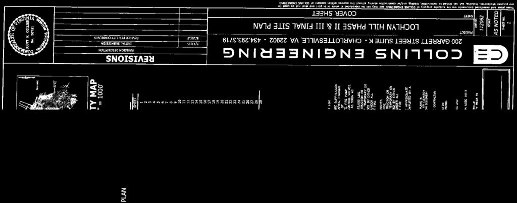
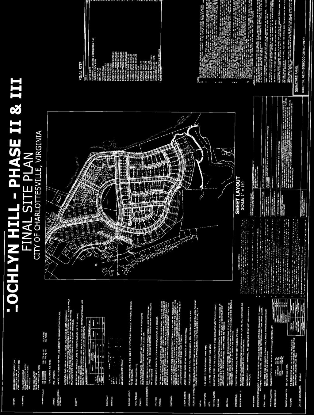
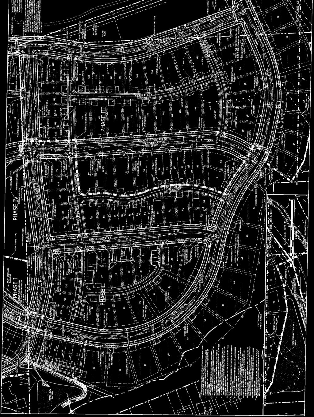
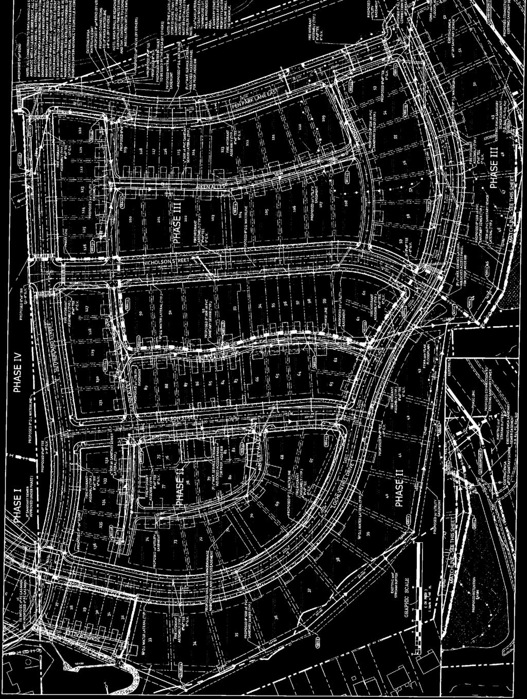
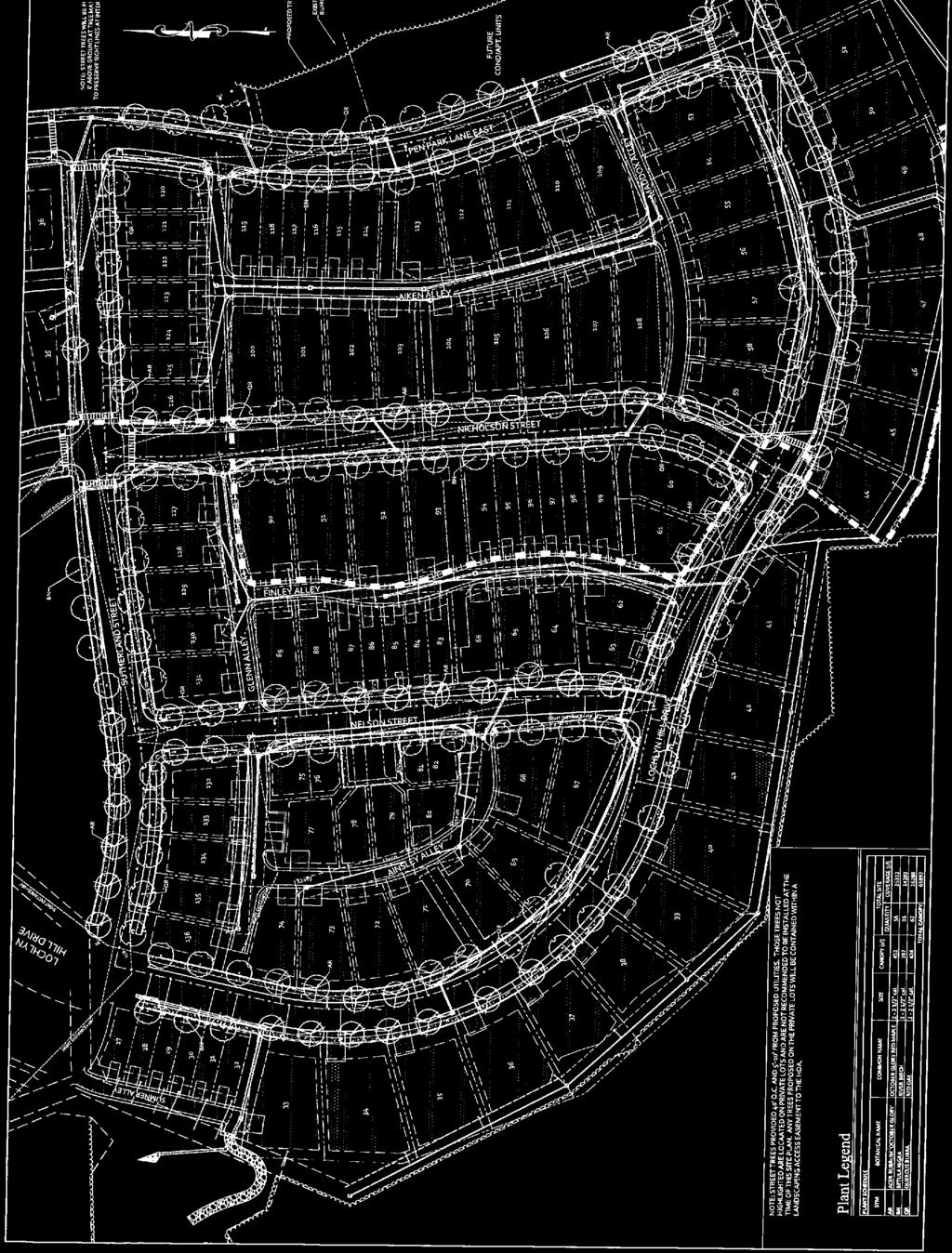
24 CITY OF CHARLOTTESVILLE DEPARTMENT OF NEIGHBORHOOD DEVELOPMENT SERVICES STAFF REPORT APPLICATION FOR APPROVAL OF PRELIMINARY SITE PLAN ( PSP ) PLANNING COMMISSION REGULAR MEETING DATE OF PLANNING COMMISSION MEETING: November 10, 2015 Author of Staff Report: Brian Haluska, Principal Planner Date of Staff Report: October 29, 2015 Project Name: Lochlyn Hill Applicant: Collins Engineering Applicant s Representative: Scott Collins, Collins Engineering Owner(s) of Property Subject to the Site Plan: Zoning District: Planned Unit Development Residential development: is a subdivision plat required? Yes If yes: date of subdivision approval: The applicant will submit a subdivision plat in accordance with the approved site plan at a later date. Date of Official Submission of the current PSP: May 28, 2014 Prior Submissions/ Comments: 1. Submission May 28, 2014, comments returned June 25, Submission November 21, 2014, comments returned January 5, Submission January 15, 2015, comments returned February 23, Submission May 13, 2015, comments returned June 29, Submission August 10, 2015, comments returned October 6, 2015 Date of Site Plan Review Conference: June 18, 2014 Reason for Planning Commission Review: City Code (d)(1) The Planning Commission is responsible for reviewing preliminary site plans in connection with existing or proposed planned unit developments. 1

. The Commission s review is ministerial in nature: if the PSP satisfies applicable requirements, the Commission must approve.")
25 Vicinity Map Standard of Review By state law, a property owner/ developer may (but is not required) to submit a preliminary subdivision plat for tentative approval. The purpose of a site plan is to assure compliance with the regulations set forth within the City s zoning ordinance, and standards for public improvements. The Planning Commission s decision to approve or deny a preliminary site plan must be based on specific provisions of the City s Zoning Ordinance and related standards (such as subdivision standards and the City s Standards and Design Manual). The Commission s review is ministerial in nature: if the PSP satisfies applicable requirements, the Commission must approve. Executive Summary Description of proposed development: construction of a sixteen (16) single-family dwelling units in Block 2B of the Lochlyn Hill Planned Unit Development (TMP 48A Parcel 39) 1- Approved PUD. City Council approved a rezoning (ZM ) to planned unit development on September 4, Amended PUD. On July 20, 2015, City Council approved an amendment to the PUD (ZM ), to authorize changes to the uses and configuration of Block 2B. Staff Recommendation: staff recommends approval, for the reasons set forth in this staff report. Site Plan Compliance As indicated above, the proposed preliminary site plan has been revised by the applicant in response to five prior sets of comments from NDS and other City Departments. 2
26 The applicant has incorporated all of staff s prior comments into this revised preliminary site plan. The staff has pending comments on the final site plan submission for the entire planned unit development, which will be addressed by the applicant prior to final site plan approval. Preliminary Site Plan (PSP) Requirements A. Compliance with applicable zoning district regulations Planned Unit Development (see Z.O ). Proffered Development Conditions dated July 12, 2012 Amended PUD Development Plan, dated June 16, 2015 The zoning administrator and staff have reviewed the site plan, and tentatively confirm that: The Uses referenced on the PSP are permitted in this planned unit development. The PSP shows dimensional requirements (building height, yard and setback requirements, etc.) that meet the requirements of the PUD concept plan. The PSP appears to propose use(s) and feature(s) consistent with the proffered development conditions and the PUD Development Plan, as amended. B. Compliance with the City s Erosion and Sediment Control Program ordinance, City Code, Chapter 10: The applicant s erosion and sediment control plan will be submitted and reviewed during final site plan submission. C. Compliance with the City s Stormwater Management Program ordinance, City Code, Chapter 10. The PSP illustrates the applicant s general approach as to how Stormwater management may be provided in accordance with state and local regulations. See item D12, following below. D. Compliance with Section Preliminary site plan contents: (a): 3D dimensional drawing or model required for all plans subject to review by Commission. Three dimensional drawings of the concept plan were submitted with the original PUD submission. None of the features shown in the original 3D submissions were affected by the 2015 PUD amendment. 3
27 (c): Engineering scale 1:20 (or alternative scale authorized by NDS) The plans were drawn at 1:40 scale, as approved by NDS because of the size of the development site (d)(1): General site plan information, including but not limited to: name(s) of all property owners; project name; tax map parcel number(s); zoning approvals; applicable ADU requirements; required yard and setback lines; USGS vertical datum; etc. Found on Sheet (d)(2): written schedules and data, demonstrating that the planned development can be accommodated on the Site, in accordance with applicable Z.O. requirements. Found on Sheet (d)(3): Phasing lines and proposed timing of development. Found on Sheet (d)(4): Topographic survey; illustration of steep slopes (areas > 25% slope) and natural streams, features and other topographic features. Found on sheet (d)(5): Existing landscape features, as described in , including location of individual trees of 6-inch caliper or greater. Found on sheet (d)(6): Name and location of all watercourses, waterways, wetlands and other bodies of water adjacent to or on the development site. Found on Sheet Sec (d)(7): Floodplain info, location of floodplain and floodway; BFE data. Found on Sheet (d)(8): Existing and proposed streets, access easements, alleys, ROW/ vehicular travelways, street names, highway route numbers, ROW lines and widths, centerline radii, and pavement widths. Found on Sheets 2, 3, and (d)(12): Location of existing and proposed ingress to and egress from the property, showing the distance to the centerline of the nearest street intersection); Found on sheet (d)(9): Details of proposed drainage and Stormwater management layout/ concept. References to specific treatments, BMPs and LID techniques is required. The applicant has provided this information to staff. A determination as to 4
28 whether the Stormwater Management Plan meets applicable requirements of state and local Stormwater management regulations will be made based on final details and calculations provided with the final site plan (d)(10): Location and size of existing water, sanitary and storm sewer facilities and easements; proposed conceptual layout for proposed new facilities. Found on Sheet (d)(11): Location of other existing and proposed utilities and utility easements (shared easements shall be provided for cable TV, gas, telephone and electric service). Found on Sheet (d)(13): Location and dimensions of all existing and proposed buildings, structures and other improvements (see also (a) (Improvements Required for Developments)). Found on Sheet 4. Based on the information provided in this submission, it appears that acceptable building areas will be provided on all proposed new lots. This will need to be re-verified prior to approval of the final subdivision plat for the development (d)(14): Identify all areas intended to be dedicated or reserved for public use (public streets, utility easements, parks, trails, etc.). Found on Sheet (d)(15): Landscape plan. Found on Sheet (d)(16): Traffic generation figures, based on VDOT rates. Trip generation numbers are shown on Sheet 1 of the site plan , generally: other information deemed necessary by NDS, in order to adequately review the preliminary site plan. Sample 1: All such information has already been provided in response to previous staff comments on the preliminary site plan. E. Compliance with Additional Standards 1. Building Site Requirements (City Code (b)(improvements must comply with critical slopes provisions). All of the building sites within the proposed development appear to be laid out in accordance with the requirements of (b). 2. Dam Inundation Zone Requirements (Va. Code ) the applicant has confirmed that the land depicted on the PSP does not lie in a mapped dam break inundation zone. 5
29 Public Comments Received No comments have been received from the public on the preliminary site plan for Block 2B. Staff Recommendation Staff recommends that the Planning Commission should grant tentative approval of the preliminary site plan, as revised through November 2, 2015, because the preliminary site plan appears to contain the information specified by City Code This tentative approval should be granted subject to the following condition(s): All of the additions, corrections and modifications set forth in the Comment Letter dated October 6, 2015 must be incorporated into the final site plan. Any later-discovered deficiency in this preliminary site plan that, if left uncorrected, would violate any City, state or federal law, regulation, engineering and safety standards or requirements, shall not be considered, treated or deemed as having been approved. General layout of public infrastructure, Stormwater management facilities, proposed buildings and structures shall be consistent with this tentative approval, subject to adjustment as necessary in accordance with final engineering data and calculations. Suggested Motion I move to grant tentative approval of this preliminary site plan, subject to all of the conditions recommended by staff. Alternative Motion I move to deny tentative approval of the preliminary site plan, as revised through November 2, 2015, because the preliminary site plan does not contain the following information required by City Code : [refer to specific provisions of ]. Attachments Preliminary Site Plan Dated August 10, 2015 Staff Site Plan Comment Letter Dated October 6, 2015 Three-dimensional model per Sec (a) 6


30
31
32
33
34
35


36 CITY OF CHARLOTTESVILLE A Great Place to Live for All of Our Citizens Department of Neighborhood Development Services City Hall Post Office Box 911 Charlottesville, Virginia Telephone Fax October 6, 2015 Scott Collins Collins Engineering 200 Garrett Street, Suite K Charlottesville, VA RE: Lochlyn Hill Planned Unit Development Dear Applicant: Thank you for presenting the final site plan for the above referenced development. Please address the following comments: Planning 1. No further comments. Engineering General 2. The inclusion of the dry swales and roof top disconnects move the design in the right direction, there are additional measures that can be used to further improve the overall stormwater concept. It should first be noted that the requirements for using rooftop disconnection are very specific, and this site may not lend itself well to that application, primarily due to the slopes. The dry swales are appropriate, but some of the locations will require close attention through the final design and construction process to ensure that the house construction does not change the drainage areas and prevent water from reaching the swales. Also, there are other locations for additional swales (i.e. along lots 86-80). Beyond the swales, there are other opportunities such as pervious pavers in the alleys, infiltration practices in common areas, soil amendments on individual lots or in common areas, etc. 3. Part 303.a and 303.b of the City Standards and Design Manual speak to including low impact development (LID) design and Infiltration Practices. The VDEQ Stormwater Design Specifications for the wet pond and extended detention also state that they should be considered only if there is remaining Treatment Volume or Channel Protection Volume to manage after all other upland runoff reduction options have been
37 Sheet 1 considered and properly credited. The city would like to see a minimum of 50% treatment by said LID measures before utilizing the pond designs. Items 1 and 2 have still not been addressed. Revisions to the stormwater detention pond were driven more by logistics of the original location conflicting with the floodway and design characteristics that were lacking per the BMP specification. 4. Per the City of Charlottesville Standards and Design manual, A landing, a minimum of fifty (50 feet in length and having a maximum vertical grade of 2%, should be provided at each intersection. As reference above per section 204.F.1, a 2% landing needs to be at ALL city intersections. Current intersections that do not meet this are Lochlyn Hill Drive & Sutherland Street, LHD & Nelson Street, LHD & Nicholson Street, and Pen Park Lane & Sutherland Street. In the July 23 rd meeting with the City, it was stated that the two intersections at Sutherland Street would be taken over by VDOT. If this is going to be the case, we need a document from VDOT stating that this will be the case. 5. All connections to VDOT right-of-way may be subject to VDOT review. See above comment. 6. Final Plans will not be approved until the CLOMAR for fill within the floodplain is approved by FEMA. (The CLOMAR shall be submitted directly to FEMA and a copy sent to the City.) Still required before final approval. 7. Building permits will not be issued until pad elevations have been verified. Please add a note to the plans stating this. 8. Lots will not receive a Certificate of Occupancy until the elevation certification has been provided. Please add a note to the plans stating this. 9. Fill within the floodplain must be based on a recommendation from a geotechnical engineer. Please add a note to the plans stating this. 10. An engineering certification will be required that states that the fill with the floodplain meets the geotechnical recommendations. Please add a note to the plans stating this. 11. Please include a note about testing requirements and that reports shall be sent to the City of Charlottesville weekly for review. All inspection reports must be received and accepted by the City prior to acceptance of the roads. Please change the wording provided from regularly to weekly. Sheet Current design allows for on street parking, therefore the center of the drive lanes is not centered in the paved surface. Please shift the crown of the road so that it is centered
38 between drive lanes. Per the July 23 rd meeting with the City, it was left to the city to review whether or not this needed to be done and we have determined that it does. 13. Please note that all structures shall be elevated at least one (1) foot above the floodplain and all mechanical equipment shall be elevated at least three (3) feet above the floodplain. Comment Satisfied. Sheet Please substitute Note 1 for the note used on Sheet 16, removing the reference of HDPE pipe. Per the July 23 rd meeting with the City, it was decided that HDPE pipe would be allowed, but that any runs beneath the roadway would be constructed using RCP. Please revise notes to reflect this. 15. Intersection of Lochlyn Hill Drive and Road B has grades exceeding 2% on the downslope. City has yet to receive acceptable documentation that VDOT will take over this intersection. Sheet Several curb spreads exceed the ½ Driving Lane + Gutter Width criteria. We recognize that gutter was removed at the City s suggestion, but several locations wouldn t meet criteria even accounting for the gutter. Please revise design to remedy. Two issues with the curb spreads. First, 2 foot curb and gutter is still being used in the calculations where there is no longer curb and gutter, and second, with one side of the roadways being labeled as no parking, that forces all on street parking all onto one side. Accounting for this, you really have two 10 foot lanes and an 8 foot parking lane, so the curb spread on the side without parking have curb spreads not exceeding 5 feet. DI s affected by this are 8, 24, 40B, 46B, 56, 60, 62, 76B, 90, 94, 96. ESC & SWM PLAN COMMENTS General 17. The inclusion of the dry swales and roof top disconnects move the design in the right direction, there are additional measures that can be used to further improve the overall stormwater concept. It should first be noted that the requirements for using rooftop disconnection are very specific, and this site may not lend itself well to that application, primarily due to the slopes. The dry swales are appropriate, but some of the locations will require close attention through the final design and construction process to ensure that the house construction does not change the drainage areas and prevent water from reaching the swales. Also, there are other locations for additional swales (i.e. along lots 86-80). Beyond the swales, there are other opportunities such as pervious pavers in the alleys, infiltration practices in common areas, soil amendments on individual lots or in common areas, etc. Please explain rational for not utilizing pervious pavers or additional dry swales where indicated in previous comments. The measures that have been revised do not address the comments pertaining to other LID measures requested. Also, in review of the provided Environmental Site Design practices and answers, we do not feel that this project fulfills the requirements as presented. Sheet 7
39 18. Please revise the estimated start date in Narrative. Please provide a REALISTIC start date in the narrative. 19. Sequence of Construction needs much more detail as it corresponds to the installation of storm pipes, dry swales, utilities, roads, buildings, etc. proposed. a. The city is looking to mitigate runoff from the site. We believe that one of the best ways to accomplish this will be to phase construction from the top, down toward the stream, while stressing the importance of stabilization and seeding of the upland areas. The E&S plans and sequence should be revised to provide specific direction to the contractor in how to phase the earthwork activities such that minimal land disturbance exists at any given point. The objective is to avoid mass grading the site and having excessive acreage disturbed. Much of the sequence of construction was revised, but it looks like there are remnants/duplicates of items. For instance, #6 talks about 1A, #7 1B and then #8 jumps back to 1A. Also, numbers 7,8,and 9 are repeated. Traffic Engineering 20. At the southern end of Nelson Street, near Lochlyn Hill Drive, there is a no parking sign situated directly in the middle of the front of a lot. There are also several no parking signs on Nicholson Street and Lochlyn Hill Drive that are situated directly in the center of the lot. Look at opportunities to shift the signs to be in front of property lines or nearer to the edge of the lot. 21. The street name sign at Sutherland Street and Lochlyn Hill Drive is directly in front of a lot. Consider collocating the street names signs throughout the development to stop signs to reduce sign clutter. 22. Add a street name sign at the intersection of Nicholson Street and Lochlyn Hill Drive 23. On the landscaping plan, add 20 sight triangles to each intersection per of our code. Either remove all vegetation and site furniture from within the triangles or add a note to the plans that ensures that vegetation will be maintained per section of the code. Building 24. No further comments. Urban Designer General 25. The applicant has specified that the overlook area will be a grass pad. Please consider including a concrete pad at the end of the sidewalk connection where people with disabilities may also enjoy the overlook. Sheet It is recommended the applicant provide curb extensions as noted in the exhibits provided with the Code of Development. Curb extensions improve pedestrian safety and visibility for all roadway users. 27. Please provide a connection from the sidewalk along the southern side of Lochlyn Hill Drive and the proposed trail connection to the end of the road.
40 28. Please consider including amenities such as benches and trash receptacles in the proposed pocket parks. Sheet Please provide additional landscaping sheets to indicate lot planting requirements are met, as noted in Table D and E of the Code of Development. Bicycle and Pedestrian Coordinator 30. Please ensure that the sidewalk on the south side of Lochlyn Hill Drive connects to the trail. Public Utilities General: 31. The City has received a flow acceptance letter from RWSA for the sanitary flow generated by this project. Additional information has been requested from the engineer about water modeling or hydrant test information. Once this is received and reviewed, the Public Utilities can provide a will serve letter for the project, if required. 32. Show the water and sewer demands for the project on the cover sheet. Sewer should be shown in gallons per day; water shall be shown in gallons per minute for max day and peak hour demands. WATER: 33. The water meters and sanitary services for the future buildings (Phase 4B) have been removed from this plan set. A new site plan submission will be required if these buildings are to be constructed in the future. 34. The 1 water service connection for the proposed hose bib needs a water meter. 35. Show the water service connection for Lots 27 and Include 2 valves at the tee near station The sanitary and storm crossings between stations and on the Lochlyn Hill profile are in the wrong locations. 38. Show all gas main crossings on the waterline profiles. 39. Show the 2 nd valve at the tee intersection of Nelson and Sutherland 40. Show the storm crossing at STA on the Nelson St. profile. 41. Check the separation at on the Nelson profile. It doesn t scale to Include a hydrant or an air release valve near at the high spot in the waterline neat the intersection of Sutherland and Lochlyn Hill Drive. Sewer: 43. Include private sewer easement for the sewer lateral across lot Move MHs 13, 14 & 16-B so that the laterals do not cross property lines. 45. Label MHs 7-B, 30A, 16A, 16-B on the plan sheet. 46. It appears there is a lateral going to MH 3 from the retention basin. What is this lateral for? 47. Revise the inverts in to MH MDW-7 and MDW-8 so that the proposed pipes match crowns with the existing larger diameter pipes. 48. Lower the invert of MH 7-B to reduce the slope between MH 7 and 7-B. 49. Show the storm crossing at station 14+50, near MH-23.
41 50. Check the rim elevations for MHs 24, 25, 26, Show the proposed grade near MH 28. Other: 52. Include all applicable utility details. All utility details can be found in the standards and design manual available on the city s website. Gas Utilities 53. No further comments. Police Department 54. No comments received. Please address these comments and re-submit your plan within 45 days, or by November 20, If you are unable to re-submit by this date, you can request a 6 month extension on the project. Please note that any letter verifying preliminary site plan approval will come via separate correspondence. If you have any questions, please feel free to contact me at and I will be happy to assist you. Sincerely, C: Meadowcreek Development, LLC Milestone Partners Brennan Duncan Christy Fisher Francis Vineyard Amanda Poncy Carrie Rainey Trip Stakem Phil Garber Harvey Finkel Brian Haluska, AICP Principal Planner
42
43
 STATEMENT OF FINAL PROFFER CONDITIONS For the LOCHL YN HILL PUD Dated as of July 12,2012 TO THE HONORABLE MAYOR AND MEMBERS OF THE COUNCIL OF THE CITY OF CH A RLOTTESVILLE: Meadowcreek")
44 BEFORE THE CITY COUNCIL OF THE CITY OF CHARLOTTESVILLE, VIRGINIA IN RE: PETITION FOR REZON ING (City Application No. ZM ) STATEMENT OF FINAL PROFFER CONDITIONS For the LOCHL YN HILL PUD Dated as of July 12,2012 TO THE HONORABLE MAYOR AND MEMBERS OF THE COUNCIL OF THE CITY OF CH A RLOTTESVILLE: Meadowcreek Development, LLC, its successors and assigns (the "AJ2plicant"), as the owner of the land described on Exhibit A hereto (the "Subject Property"), seeks to amend the current zoning of the Subject Property from R-2 to Planned Unit Development as described in the Lochlyn Hill Code of Development dated May 8, 2012, last revised July 12, (the "PUD Development Plan") and subject to the voluntary development conditions set fo11h below (the "Proffers"). The Applicant hereby proffers and agrees that, if the Subject Property is rezoned as requested by the City of Charlottesville (the "City") in application ZM , the rezoning will be subject to, and the Applicant will abide by, the approved PUD Development Plan and the Proffers in the development of the Subject Property. If rezoning application ZM is denied, the PUD Development Plan and the Proffers shall be null and void. I. Affordable Housing - No less than 15% (the "Affordability Threshold") of the total number of residential units constructed on the Subject Property shall meet the requirements for an Affordable Dwelling Unit as defined below. Affordable Dwelling Units may include single family detached units, single family attached units, attached or detached accessory dwellings, apartments or condominiums. (a) Affordability defined. For the purposes of this Proffer I, an "Affordable Dwelling Unit" shall mean a residential dwelling unit affordable to a household whose income is less than 80% of the area median family income as provided by the U.S. Department of Housing and Urban Development ("HUD") from time to time for the area encompassing the Subject Prope1ty (a "Qualified Household"), such that the Qualified Household's housing costs consisting of principal, interest, real estate taxes, and homeowne1js insurance (PIT!) do not exceed 30% of the Qualified Household's gross income. Certain credits against the Affordability Threshold are permitted notwithstanding the foregoing definition, as more particularly provided herein. (b) For-Sale Affordable Units. A po1tion of the total Affordable Dwelling Units provided on the Subject Property to satisfy the Affordability Threshold shall be for-sale units as provided in this Proffer I (b ). (i) Number. Not less than 11 % of the total number of for-sale residential units constructed on the Subject Property, or 11 residential units, whichever is greater, shall be for-sale Affordable Dwelling Units. The requirements of this proffer l(b) shall be satisfied by sales of Affordable Dwelling Units to Qualified Households using funds from the Lochlyn Hill Housing Trust Fund as described in (i i) below and by sales of finished residential lots or dwelling units to Nonprofit Housing Providers as described in (iii) below.
 for the purpose of making units available for sale to Qualified Households by providing")
45 (ii) (iii) (iv) Housing Trust Fund. The Applicant shall establish a housing trust fund for the Subject Property (the "Housing Trust Fund") for the purpose of making units available for sale to Qualified Households by providing downpayment and closing cost assistance in amounts sufficient to make otherwise-unaffordable units into Affordable Dwelling Units for such Qualified Households. The Applicant shall fund a minimum of $1 50,000, in the form of cash and/or notes, into the Housing Trnst Fund, at such times and in such amounts as may be necessary to enable the Housing Trust Fund to provide sufficient downpayment and closing cost assistance to Qualified Households to meet the enforcement targets set forth in (iv) below. The funds deposited by the Applicant, together with any other funds deposited therein, shall provide a revolving source of funds for downpayment and closing cost assistance to Qualified Households for the purchase of Affordab le Dwelling Units on the Subject Property. All funds held in the Housing Trust Fund shall be used to promote affordability within the Lochlyn Hill Neighborhood. The Housing Trust Fund shall be managed by Piedmont Housing Alliance or another charitable organization designated by the Applicant and approved by the City's Director of Neighborhood Development Services. Notes held by the Housing Trust Fund shall conform to ce11ain general terms and requirements consistent with the purpose of the Housing Trust Fund. Sales to Nonprofit Housing Providers. The Applicant shall sell a minimum of 3 finished residential lots or dwelling uni ts (collectively, the "Nonprofit Units") on the Subject Prope11y to one or more of the followi ng nonprofit housing providers: Thomas Jefferson Community Land Trust, Piedmont Housing Alliance, Jefferson Area Board for Aging, Inc., or other nonprofit housing provider designated by the Applicant and approved by the City's Director of Neighborhood Development Services (the "Nonprofit Housing Providers"). Applicant shall sell such Nonprofit Units to the Nonprofit Housing Providers at a 15% discount to prevailing market rates at the time of conveyance, or at Applicant's cost, whichever is greater. The execution of a contract to sell any Nonprofi t Unit to a Nonprofit Housing Provider shall be deemed to create an Affordable Dwelling Unit and shall be credited against the Applicant's obligation to provide for-sale Affordable Dwelling Units under Proffer l(b). If, within 12 months after execution of a contract between the Applicant and a Nonprofit Housing Provider, the parties are unable to close on the acquisition of a Nonprofit Unit through no fault of the Applicant, then the Applicant's obligation to sell such Nonprofit Unit shall be deemed satisfied and shall be credited against the Applicant's obligation to provide for-sale Affordable Dwelling Units under Proffer l(b) and the Applicant shall be free to sell such residential lot or dwelling unit without restriction. Enforcement. Prior to the issuance of the 50th building permit within the Subject Property, the Applicant shall have closed on the sale of at least 5 Affordable Dwelling Units or Nonprofit Units. Prior to the issuance of the IOOth building permit within the Subject Prope11y, the Applicant shall have closed on the sale of at least 6 additional Affordable Dwelling Units or Nonprofit Units. In the event that additional for-sa le Affordable Dwelling Units are required to satisfy the requirements of this Proffer I (b ), they shall be provided as follows: the Applicant shall have closed on the sale of at least 1 additional Affordable Dwelling Unit or Nonprofit Unit before the issuance of the 109th, I 18th and 127th building permits within the Subject Property. 2
46 (c) Accessory Dwelling Units. The Applicant shall construct not less than 15 Accessory Dwelling Units ("ADUs") on the Subject Property. Such ADUs shall be credited toward satisfaction of the Affordability Threshold at the rate of 3 AD Us = I Affordable Dwelling Unit. Such credit shall be recognized for a maximum of 45 ADUs, so that this proffer l(c) shall generate an aggregate credit against the affordable housing proffer of not less than 5 nor more than 15 Affordable Dwelling Units. For the purpose of this Proffer l{c), an "Accessory Dwelling Unit" may be attached or detached, and shall be permitted, constructed and sold with a primary dwelling unit on the same lot and may include, without limitation, accessory apa1tments as defined in Section of the City's Code of Ordinances in effect as of this date of these Proffers. Certificates of occupancy for the AD Us required by this Proffer I ( c) (which may be included within the ce1tificate of occupancy for the primary dwelling unit) shall have been issued within I 0 years fo llowing issuance of the first building permit within the Subject Property. (d) For-Rent Affordable Units. The Applicant may elect to meet the Affordability Threshold entirely through the provision of for-sale Affordable Housing Units as described in proffer l{b) and the ADUs described in Proffer l(c), or the Applicant may, at its option, meet any remaining portion of the Affordability Threshold through the provision of rental apartments on the Subject Property (the "For-Rent Affordable Units") or through payment of a cash proffer as provided in this proffer l(d). If the Applicant elects to provide any of the required Affordable Dwelling Units through rental apartments, the Applicant shall so notify the City's Director of Neighborhood Development Services in writing of its decision prior to the issuance of the certificate of occupancy for the multifamily building to be located within Block 48 of the Subject Property. The completed For-Rent Affordable Units provided by the Applicant shall then be offered for rent only to Qualified Households (as defined in proffer I (a) above) at then-applicable HUD Fair Market Rents. If HUD ceases to publish Fair Market Rents, then rent for the For-Rent Affordable Units shall be set with reference to a replacement publication approved by the City's Director of Neighborhood Development Services. The requi rement that the rents for the For-Rent Affordable Units not exceed the maximum rents established in this Proffer I ( d) shall apply for a period of 5 years following issuance of the certificate of occupancy for the building in which the For-Rent Affordable Units are located (the "Affordable Term"). The Applicant shall report the rental rates for the For-Rent Affordable Units and incomes of the occupants to the City's Director of Neighborhood Development Services each year during the Affordable Term. At any point before or during the Affordable Term, the Applicant may release any or all of the For-Rent Affordable Units from the restrictions of this Proffer 1 ( d) by making a payment in the amount of $7,000 per For-Rent Affordable Unit to the Charlottesville Housing Fund or to another nonprofit housing provider designated by the City's Director of Neighborhood Development Services. (e) Successors bound. The Affordability Threshold and other requirements of this Proffer l shall apply to the Subject Property as a whole and not to individual site plans and subdi vision plats. The Applicant may designate on a site plan or subdivision plat of any portion of the Subject Property a number or percentage of the Affordable Dwelling Units required by this Proffer I to be constructed on the land depicted thereon; provided that such des ignation shall not expand the Applicant's obligations under the Proffers. The Applicant shall convey the responsibility for creating the Affordable Dwelling Units to the subsequent owner(s) or developer(s) of the Subject Property (or any po1tion thereof), and such subsequent owner(s) and/or developer(s) shall succeed to the duties of the 3

47 Applicant under this Proffer I, and the term "Applicant" shall refer to such subsequent owner(s) and/or developer(s), as applicable. 2. Pedestl'ian Connection to Rio Road - The Applicant shall construct a sidewalk between the Subject Property and Rio Road as provided in this Proffer 2. Upon receipt of necessary approvals from Albemarle County (the "County") and the Virginia Department of Transportation ("VDOT"), but not earlier than the date of issuance of the first building permit within the Subject Property, the Applicant shall construct a sidewalk along one side of Pen Park Lane from the Subject Property to the intersection with Rio Road. The Applicant's obligation under this Proffer 2 shall be contingent on the provision, without cost to the Applicant, of adequate right-of-way and easements necessary for the sidewalk to be constructed and maintained; provided, however, that the Applicant shall cooperate with the County and VDOT to obtain such right-of-way and easements. In the event that the requisite approvals, right-of-way and easements have not been provided within l 0 years following issuance of the first building permit within the Subject Property, then this Proffer 2 shall be deemed satisfied and the Applicant shall have no frn1her obligation under this Proffer Bicycle Path and Greenway Dedication - The Applicant shall provide land and a cash contribution toward construction of a paved bicycle path traversing the side of the Subject Property that parallels Meadow Creek and connecting the Subject Prope11y to the City of Charlottesville's existing trails network (the "Bike Path"), as provided in this Proffer 3. Upon receipt of notice from the City that (a) all necessary right-of-way has been acquired to connect the Subject Property to the City's existing trails network, (b) funds necessary for constructing a paved bicycle path between the Subject Property and the City's existing paved trail or street network have been allocated by the City, (c) plans for constructing the paved bicycle path (including the Bike Path on the Subject Property) have been approved by the City, and (d) the City is prepared to move forward with the construction of a paved bicycle path between the Subject Property and the City's existing paved trail or street network, then, within 12 months after the Applicant's receipt of such notice, but not earlier than the date of issuance of the first building permit within the Subject Property, the Applicant shall (i) dedicate to the City sufficient area for the Bike Path and a parallel greenway area surrounding the Bike Path of not less than 50 feet and not more than I 00 feet in width generally in the location shown on the Development Plan (the "Land") and (ii) make a cash contribution to the City in the amount of $15,000, with any unexpended funds to be retained by the City and used toward funding trail maintenance (the "Cash Contribution"). In the event that the conditions for the Applicant's obligation to dedicate the Land and pay the Cash Contribution have not occurred within 10 years fo llowing issuance of the first building permit within the Subject Prope11y, then the Applicant shall quitclaim the Land to the City in full satisfaction of this Proffer 3 and shall have no obligation to make the Cash Contribution. 4. Funding for Rio/Pen Park Lane Traffic Signal - The Applicant shall provide up to 2 signal warrant studies and a contribution of cash toward the design and construction of a traffic signal at the intersection of Rio Road and Pen Park Lane (the "Traffic Signal") and/or design and construction of a right turn lane on Pen Park Lane its intersection with Rio Road (the "Turn Lane") as provided in this Proffer 4. Within 30 days after the issuance of the SOth building permit within the Subject Property, the Applicant shall obtain a signal warrant study by a traffic engineer approved by VDOT and the City traffic engineer of the intersection of Rio Road and Pen Park Lane (the "First Study") and provide copies of the study, within 30 days after completion of the study, to the City's traffic engineer and to VDOT. In the event that the First Study concludes that the conditions warrant construction of the Traffic Signal and/or the construction of a Tum Lane and VDOT accepts the First Study in writing, then, 4

48 within 30 days after VDOT has provided a written estimate of final costs and a firm construction schedule for the Traffic Signal and/or the Turn Lane, the Applicant shall contribute $65,000 toward the design and construction of the Traffic Signal and/or the Turn Lane to the City, VDOT, or their designee. Under no circumstances shall the contribution by the Applicant exceed $65,000. In the event that the First Study concludes that conditions do not warrant construction of the Traffic Signal and/or Turn Lane, or if VDOT does not accept the First Study, then the Applicant shall conduct a second signal warrant study of the intersection of Rio Road and Pen Park Lane before the issuance of the I OOth building perm it within the Subject Property by a traffic engineer approved by VDOT and the City traffic engineer of the intersection of Rio Road and Pen Park Lane (the "Second Study") and provide copies of the study, within 30 days after completion of the study, to the City's traffic engineer and to VDOT. In the event that the Second Study concludes that the conditions of a Traffic Signal and/or Turn Lane are met and VDOT accepts the Second Study in writing, then, within 30 days after VDOT has provided a written estimate of final costs and a firm construction schedule for the Traffic Signal and/or Turn Lane, the Applicant shall contribute $65,000 toward the design and construction of the Traffic Signal and/or Turn Lane to the City, VDOT, or their designee. In the event the Second Study concludes that conditions do not warrant construction of the Traffic Signal and/or Turn Lane, or if VDOT does not accept the Second Study, then this Proffer 4 'ihall be deemed satisfied and the Applicant shall have no fu 1her obligation under this Proffer 4. Any funds paid by the Applicant under this proffer 4 that are not expended for the design and construction of the Traffic Signal and/or Turn Lane within 12 months following the Applicant's payment of such funds shall be promptly returned to the Applicant, in which case the Applicant shall have no further obligation with respect to this Proffer 4. Notwithstanding anything to the contrary contained in this Proffer 4, in the event that conditions triggering the Applicant's obligation to perform any signal warrant study or pay any cash proffer described in this Proffer 4 have not occurred within I 0 years following issuance of the first building permit within the Subject Property, then this Proffer 4 shall be deemed satisfied and the Applicant shall have no further obligation under this Proffer 4. WHEREFORE, the undersigned Applicant requests that the Subject Property be rezoned as requested, in accordance with the Zoning Ordinance of the City of Charlottesville. Respectfully submitted this 12th day of July, Applicant's Address: 300 Second Street NE Charlottesville, VA
49 CITY OF CHARLOTTESVILLE DEPARTMENT OF NEIGHBORHOOD DEVELOPMENT SERVICES STAFF REPORT REQUEST FOR A ZONING TEXT AMENDMENT ZT : ALCOHOLIC BEVERAGE PRODUCTION ZONING AMENDMENTS JOINT PUBLIC HEARING DATE OF PLANNING COMMISSION MEETING: November 10, 2015 Author of Staff Report: Brian Haluska Date of Staff Report: October 28, 2015 Applicable City Code Provisions: Chapter 34 (Zoning Ordinance) Executive Summary An ordinance to revise and expand the existing definition of a microbrewery within the City, and to make provisions for small-scale brewery operations that exceed the current definition of a microbrewery in the code. Background At their October 19, 2015 meeting, the City Council approved an initiation of a zoning text amendment related to the definition of microbreweries in the City of Charlottesville. The memo on the matter referred to a City-based brewery that raised concerns about the City s limitation on the amount of beer a brewery can produce under the microbrewery definition. Currently, a brewery operation that exceeds 15,000 barrels of production a year is classified as a beverage bottling facility, and can only be located in industrial zones. Additionally, staff raised a concern about the consistency with a microbrewery definition that permits the production of beer within several mixed-use zones, but does not permit small scale winery or distillery operations. Standard of Review As per state law and of the City Code, the planning commission is required to review this proposed amendment to determine: (1) Whether the proposed amendment conforms to the general guidelines and policies contained in the comprehensive plan; (2) Whether the proposed amendment will further the purposes of this chapter and the general welfare of the entire community; (3) Whether there is a need and justification for the change; and 1
50 (4) Whether the amendment is required by the public necessity, convenience, general welfare or good zoning practice. Discussion of the Proposed Draft Ordinance The full text of the proposed draft ordinance is attached to this report. The sections proposed for modification are section of the zoning ordinance, which would be updated to reflect new definitions of alcoholic beverage production facilities, and the three use matrices in the Zoning Ordinance. The specific changes to the ordinance are: Section The section would be modified to add a new definition for Micro-producers. This will be an overarching category that will include those uses currently classified as microbreweries, as well as micro-wineries and micro-distilleries. The existing limit of 15,000 barrels per year will be retained for microbreweries, while production at micro-wineries and micro-distilleries will be limited to no more than 5,000 gallons per year. The 5,000 gallon limit is used by the Virginia Department of Alcoholic Beverage Control as a dividing line for licenses for wineries and distilleries. Micro-producers would also be required to have some form of commercial activity in addition to their production facility. Additionally, a new definition will be added for Small Breweries that will limit production of beer at such facilities to no more than 30,000 barrels per year. City staff settled on the limit of 30,000 as a maximum for these types of facilities because a search of ABC licensees for breweries revealed that only 5 facilities in the state are licensed to produce over 10,000 barrels per year. Staff felt that any facility larger than 30,000 would be best located in the industrial zones of the City. Lastly, the staff recommends a change to the existing definition of Brewery and bottling facility that clarifies that the use is limited to brewery operations without commercial components. Section The current land use category Microbreweries would be amended to read Micro-producers, and a new category for Small Breweries would be added to the matrix. Neither use would be permitted in any of the residential districts. Section The current land use category Microbreweries would be amended to read Micro-producers, and a new category for Small Breweries would be added to the matrix. Microbreweries are currently permitted by-right in the B-2, B-3, M-I and IC corridors. Micro-producers would be permitted by right in the same zones. 2
51 Staff proposes permitting Small Breweries by right in the M-I and IC districts, and by special use permit in the B-2 and B-3 districts. Section The current land use category Microbreweries would be amended to read Micro-producers, and a new category for Small Breweries would be added to the matrix. Microbreweries are currently permitted by-right in the Downtown, Downtown Extended, Downtown North, West Main North, West Main South, High Street, Highway Commercial, Water Street, Urban, South Street, Corner and Central City corridors. Micro-producers would be permitted by right in the same zones. Staff proposes permitting Small Breweries by special use permit in the Downtown Extended, Highway, Urban, and Central City corridors. Staff Analysis 1. Does the proposed amendment conform to the general guidelines and policies contained in the comprehensive plan? The Land Use chapter of the Comprehensive Plan lists the following goals: When considering changes to land use regulations, respect nearby residential areas. Encourage small businesses that enhance existing neighborhoods and employment centers. Increase opportunities for employment centers and diverse employment opportunities, particularly in targeted industries and businesses. The Economic Sustainability chapter of the Comprehensive Plan lists the following goals: Work with partners to help entrepreneurs identify locations/sites where they can successfully start and grow their companies. Work strategically to continue to develop and implement land use policies and regulations that ensure the availability of sites for businesses to locate and expand. 2. Does the proposed amendment further the purposes of the Zoning Ordinance (Chapter 34, City Code) and the general welfare of the entire community? Section 34-3(3) of the City Code states that a purpose of the zoning ordinance is in part to regulate and restrict the location of trades, industries and residences and Encourage economic activities that provide desirable employment and enlarge the tax base. 3. Is there a need and justification for the change? The justification for the change is two-fold. The first is to give local craft brewers some sites where they can potentially relocate to if their operations begin to increase beyond the size of the City s definition of a microbrewery, but can still be accommodated within the City. 3
52 The second justification is to provide micro-winery and micro-distillery operations the same opportunities to locate in the City that microbreweries currently enjoy. Public Comment Staff has received no comment on this matter. Recommendation Staff recommends approval of the zoning text amendment. Possible Motions 1. I move to recommend to City Council that it should amend Sections , , and of the zoning ordinance, to define micro-producers of alcoholic beverages and small breweries and designate which zones of the City those uses may be located, as presented in the draft ordinance provided by staff, because I find that this amendment is required by the public necessity, convenience, general welfare or good zoning practice. 2. I move to recommend to City Council that it should amend Sections , , and of the zoning ordinance, to define micro-producers of alcoholic beverages and small breweries and designate which zones of the City those uses may be located, with the following changes: a. b. I find that the draft ordinance presented by staff, with these changes, is required by the public necessity, convenience, general welfare or good zoning practice. 3. I move to recommend to City Council that it should not amend Sections , , and of the zoning ordinance, to define micro-producers of alcoholic beverages and small breweries and designate which zones of the City those uses may be located, because I find that the amendment is not required by the public necessity, convenience, general welfare or good zoning practice. Attachments Proposed amendment to Sections , , and
53 Attachment Sec Definitions Beverage or food processing packaging and bottling plants means a business/ industrial manufacturing facility where foods and/or beverages are processed and packaged for local, regional or national distribution. This definition does not include a facility engaged in the brewing / and bottling of beverages (see brewery and bottling facilities) Brewery means a facility in which beer is manufactured by a person licensed by the Commonwealth of Virginia as a brewery. Brewery (small) means a brewery (i) that produces fewer than 30,000 barrels per year of beer, and (ii) the brewery sells directly to the consumer on-site within a retail shop, bar, tap- room, or restaurant. Brewery and bottling facility means a business/ industrial manufacturing facility where beverages are brewed and bottled for local, regional or national distribution. Samples may be offered to individuals visiting the premises, for on-site consumption, but there are no retail or other sales directly to consumers within any taprooms, bars, restaurants, or similar facilities. Micro-producers means a microbrewery, microwinery, or microdistillery where (i) the area devoted to the manufacturing, bottling and warehouse/ distribution functions, collectively, is 3,000 square feet (GFA) or less, and (ii) 25% or more of such production is sold directly to the consumer on-site, within a bar, tasting room, or restaurant. Microbrewery means a facility for the production and packaging of malt beverages of low alcoholic content for distribution, retail, or wholesale, on or off premise, with a capacity of not more than 15,000 barrels per year. The development may include other uses such as a standard restaurant, bar or live entertainment as otherwise permitted in the zoning district. Microwineries means a facility for the production and packaging of wine for distribution, retail, or wholesale, on or off premise, with a capacity of not more than 5,000 gallons per year. The development may include other uses such as a standard restaurant, bar or live entertainment as otherwise permitted in the zoning district. Microdistillery means a facility for the production and packaging of distilled spirits for distribution, retail, or wholesale, on or off premise, with a capacity of not more than 5,000 gallons per year. The development may include other uses such as a standard restaurant, bar or live entertainment as otherwise permitted in the zoning district. 5
54 Section Use matrix Residential zoning districts. Use Types Microbrewery Micro-producers Small Breweries Zoning Districts R-1 R-1U R-1S R-1SU R-2 R-2U R-3 R-UMD R-UHD MR MHP Section Use matrix Commercial districts. Use Types Zoning Districts B-1 B-2 B-3 M-I ES IC Microbrewery B B B B Micro-producers Small Breweries S S B B Section Use matrix-mixed use corridor districts. Use Types Zoning Districts D DE DN WMN WMS CH HS NCC HW WSD URB SS CD CC Microbrewery B B B B B B B B B B B B Micro-producers Small Breweries S S S S 6

55 CITY OF CHARLOTTESVILLE DEPARTMENT OF NEIGHBORHOOD DEVELOPMENT SERVICES STAFF REPORT TO THE ENTRANCE CORRIDOR REVIEW BOARD (ERB) ENTRANCE CORRIDOR (EC) CERTIFICATE OF APPROPROPRIATENESS DATE OF PLANNING COMMISSION MEETING: November 10, 2015 Project Name: 2307 Hydraulic Road Extra Space Self Storage Development Planner: Mary Joy Scala, AICP Applicant: Taylor/Theus Holdings, Inc. Applicant s Representative: David Ellison Applicant s Relation to Owner: Contract purchaser Application Information Property Street Address: 2307 Hydraulic Road Property Owner: Gray Television Group, Inc. Tax Map/Parcel: Tax Map 40C, Parcel 46 (Online Record: 40C ) Total Square Footage/Acreage Site: acres Comprehensive Plan (Land Use Plan) Designation: Commercial Current Zoning Classification: M-1 Industrial with Entrance Corridor (EC) Overlay Entrance Corridor Overlay District: (a)(2) Hydraulic Road Current Usage: Building (to be demolished) currently used for office. Background The ERB reviews Entrance Corridor Certificate of Appropriateness applications when the proposal is for new construction. Applicant s Request The applicant is requesting approval of a certificate of appropriateness to construct one 3-story self-storage building with an office facing Hydraulic Road. The existing brick, one-story building will be demolished. The new vehicular circulation includes two entrances from Inglewood Drive to access 9 surface parking spaces, including one HC space, and additional parking/loading spaces. There is a partial existing 5-foot sidewalk along Hydraulic Road, but none on Inglewood Drive. New 5 foot sidewalks are proposed along Hydraulic Road and Inglewood Drive. The main pedestrian walkway links to the public sidewalk on Hydraulic. 1
56 Three existing street trees are proposed to be saved in the front yard, a 21 Locust, a 33 unidentified tree, and a 6 double dogwood. Additional street trees are proposed along Hydraulic Road and Inglewood Drive, including Lindens and Zelkovas. New 10 ft. wide S-3 vegetative screening buffers are proposed along the other two sides, and along Inglewood Drive. Ginkgo trees are proposed in planting islands in the loading area /parking lot. Building materials consist of three shades of brick facing the two roads, with brick also wrapping around the corners of the building. The two sides that do not face roads will have taupe color metal siding, with accents of medium color brick. The overhead doors, awnings, coping, gutters, and downspouts are green metal. Two wall signs are proposed on the building. Standard of Review The Planning Commission serves as the entrance corridor review board (ERB) responsible for administering the design review process in entrance corridor overlay districts. This development project requires a site plan, and therefore also requires a certificate of appropriateness from the ERB, pursuant to the provisions of (a)(3) of the City s Zoning Ordinance. The ERB shall act on an application within 60 days of the submittal date, and shall either approve, approve with conditions, or deny the application. Appeal would be to City Council. Standards for considering certificates of appropriateness: In conducting review of an application, the ERB must consider certain features and factors in determining the appropriateness of proposed construction, alteration, etc. of buildings or structures located within an entrance corridor overlay district. Following is a list of the standards set forth within of the City Code: (1): Overall architectural design, form, and style of the subject building or structure, including, but not limited to: the height, mass and scale; The proposed building is 3 stories in height, but is designed to appear 2 stories. The roofs are flat. The building is very long, feet, and has a gross floor area of 98,767 sq. feet (2): Exterior architectural details and features of the subject building or structure; The customer office has two entrances: facing the Hydraulic Road sidewalk and facing the parking area. There are four entrances marked with awnings, to provide access to the storage spaces. Three face the Inglewood Road, and one is on the rear elevation (called side elevation in the application). The entrances are storefront-type sliding doors. The third floor windows face interior corridors or blank interior walls. The siding materials and colors provide modulation of the exterior walls. 2
57 No lighting has been shown. A lighting plan will be required at final site plan submission. Signage is restrained (3): Texture, materials and color of materials proposed for use on the subject building or structure; The proposed building materials consist of: three shades of brick walls, and taupe metal walls with brick wall accents. The overhead doors, awnings, coping, gutters, and downspouts are green metal (4): Design and arrangement of buildings and structures on the subject site; The building is functionally located on the long, narrow lot. Vehicular access and parking are on the side street. There is a small front yard with three existing trees to be saved, and substantial landscaping provided on all sides of the building (5): The extent to which the features and characteristics described within paragraphs (1)-(4),above, are architecturally compatible (or incompatible) with similar features and characteristics of other buildings and structures having frontage on the same EC street(s) as the subject property. The goals are to make the site function well for the users of this site and the corridor, and to have an attractive development that is compatible with its surrounding context. The features and characteristics of the buildings and site described above will be architecturally compatible with other buildings on Hydraulic Road. Some of the features and characteristics that help make it compatible are: the 3-story, 31 foot building height, pedestrian scale; relegation of parking; orientation to the street; sustainable building materials; modulated wall treatment, restrained signage; and substantial landscaping (6): Provisions of the Entrance Corridor Design Guidelines. Relevant sections of the guidelines include: Section 1 (Introduction) The Entrance Corridor design principles are expanded below: Design For a Corridor Vision New building design should be compatible (in massing, scale, materials, colors) with those structures that contribute to the overall character and quality of the corridor. Existing developments should be encouraged to make upgrades consistent with the corridor vision. Site designs should contain some common elements to provide continuity along the corridor. New development, including franchise development, should complement the City s character and respect those qualities that distinguish the City s built environment. Preserve History 3
58 Preserve significant historic buildings as well as distinctive architecture from more recent periods. Encourage new contemporary design that integrates well with existing historic buildings to enhance the overall character and quality of the corridor. Facilitate Pedestrian Access Encourage compact, walkable developments. Design pedestrian connections from sidewalk and car to buildings, between buildings, and between corridor properties and adjacent residential areas. Maintain Human Scale in Buildings and Spaces Consider the building scale, especially height, mass, complexity of form, and architectural details, and the impact of spaces created, as it will be experienced by the people who will pass by, live, work, or shop there. The size, placement and number of doors, windows, portals and openings define human scale, as does the degree of ground-floor pedestrian access. Preserve and Enhance Natural Character Daylight and improve streams, and retain mature trees and natural buffers. Work with topography to minimize grading and limit the introduction of impervious surfaces. Encourage plantings of diverse native species. Create a Sense of Place In corridors where substantial pedestrian activity occurs or is encouraged, or where mixed use and multibuilding projects are proposed, one goal will be creating a sense of place. Building arrangements, uses, natural features, and landscaping should contribute, where feasible, to create exterior space where people can interact. Create an Inviting Public Realm Design inviting streetscapes and public spaces. Redevelopment of properties should enhance the existing streetscapes and create an engaging public realm. Create Restrained Communications Private signage and advertising should be harmonious and in scale with building elements and landscaping features. Screen Incompatible Uses and Appurtenances: Screen from adjacent properties and public view those uses and appurtenances whose visibility may be incompatible with the overall character and quality of the corridor, such as: parking lots, outdoor storage and loading areas, refuse areas, mechanical and communication equipment, Where feasible, relegate parking behind buildings. It is not the intent to require screening for utilitarian designs that are attractive, and/or purposeful. Respect and Enhance Charlottesville s Character Charlottesville seeks new construction that reflects the unique character, history, and cultural diversity of this place. Architectural transplants from other locales, or shallow imitations of historic architectural styles, for example, are neither appropriate nor desirable. Incompatible aspects of franchise design or corporate signature buildings must be modified to fit the character of this community. Section 2 (Streetscape) 4
59 Staff Analysis: The complex is correctly oriented to Hydraulic Road. The street trees and new sidewalks will create a nice frontage and a comfortable place to walk. Section 3 (Site) Staff Analysis: The landscaped yards are designed to protect the abutting residential properties. Setback. Section 4 (Buildings) Staff Analysis: A building of this height, mass and scale is appropriate in this area. Varied materials and color are used to break up the massing of the building. Brick and metal siding are recommended, sustainable materials. Section 5 (Individual Corridors): Hydraulic Road Vision There is potential for redevelopment of the older sites along the corridor including K-Mart Plaza and Dominion Power. Large new buildings should be designed to reduce mass. Opportunities include: building closer to Hydraulic Road, adding landscaping along the streets and in parking lots, and creating pedestrian and auto connectivity within and between developments. A new road could provide access to sites to the north. Preserving a stream buffer and extending a greenway along Meadow Creek are additional needs. West of Rt. 29 pedestrian connections would be important if older commercial and residential properties along Hydraulic Road are redeveloped. Public Comments Received No public comments have been received to date regarding the EC application. Staff Recommendations In staff s opinion, the project is well-designed, and meets the standards and guidelines for a certificate of appropriateness in the Entrance Corridor. Staff recommends approval of this application subject to final administrative site plan approval. Suggested Motion 1. I move to approve the Entrance Corridor Certificate of Appropriateness application for the new self-storage building at 2307 Hydraulic Road, subject to final administrative site plan approval. Attachments: EC Application form and narrative (2 pages) 5
60 EC Submission Packet dated 10/20/2015 (7 pages) EC Site Plan dated 10/28/2015 (7 pages) 6


61


62
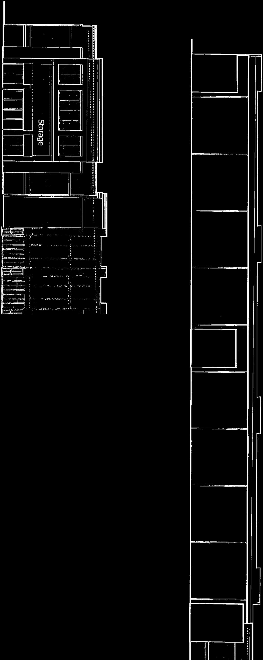
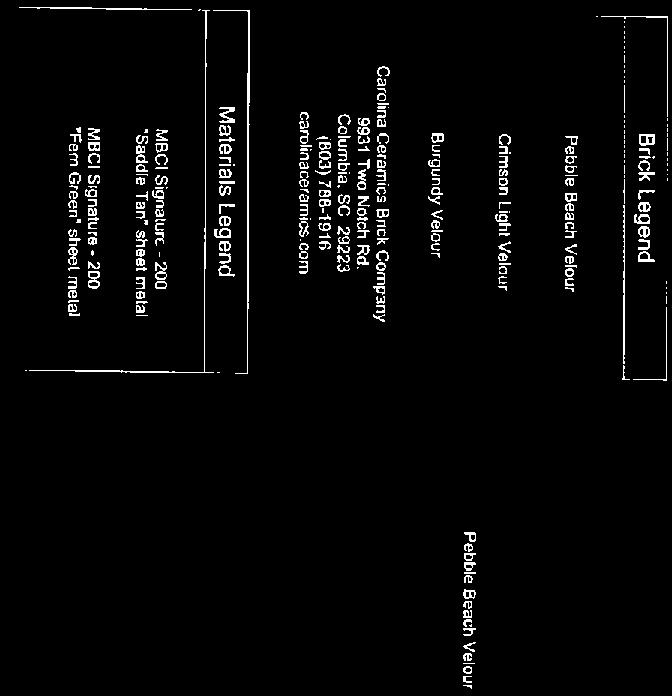


63
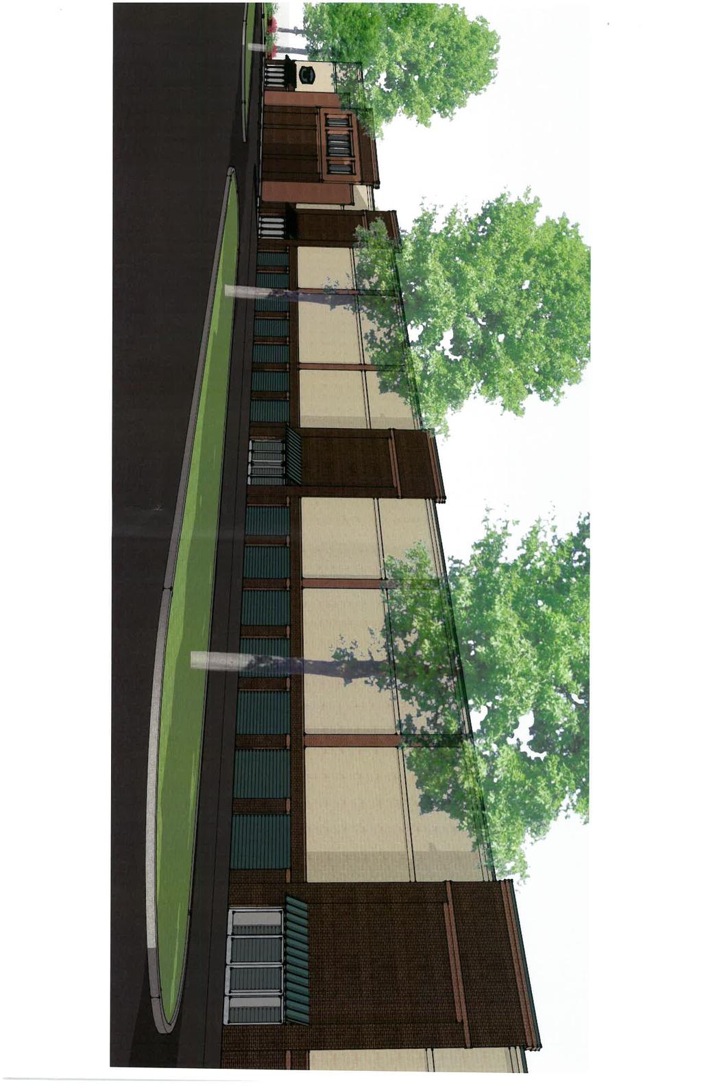
64
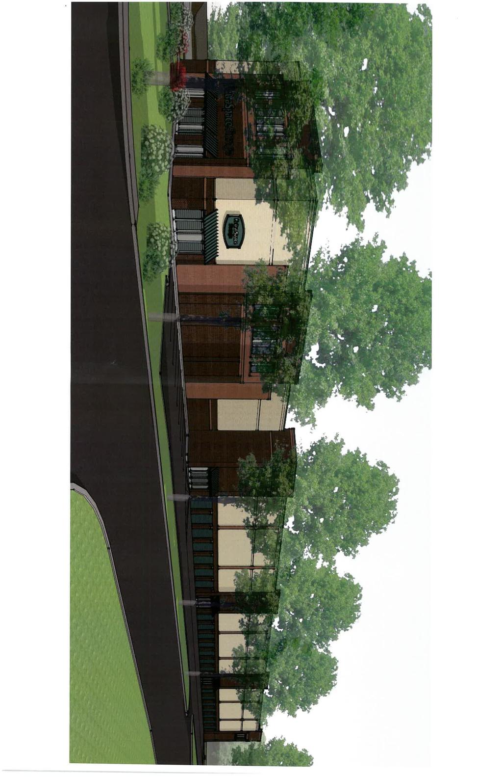
65
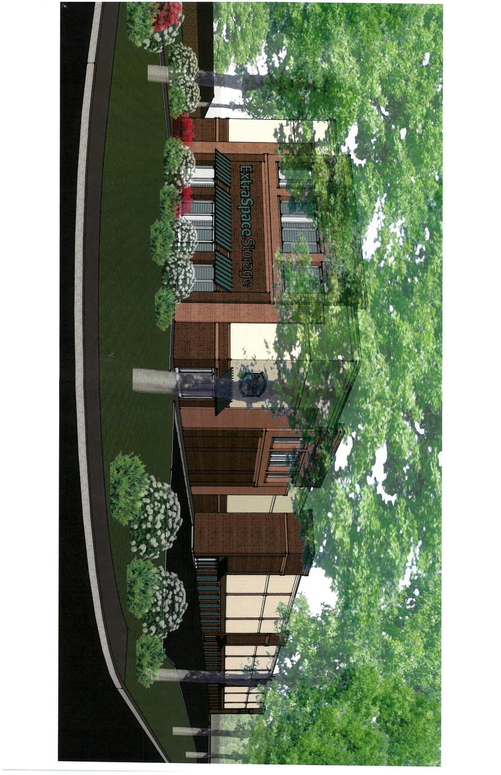
66
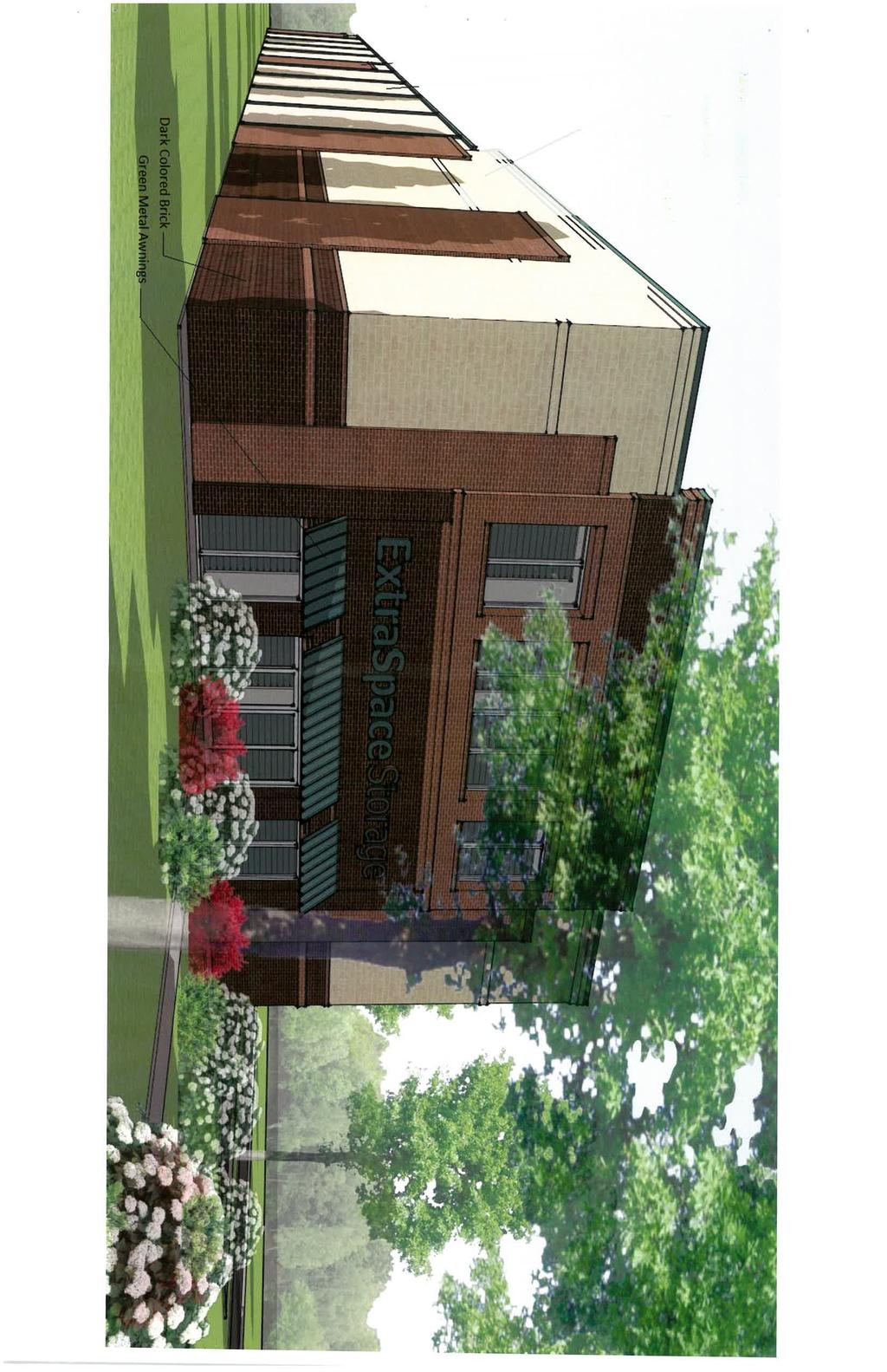
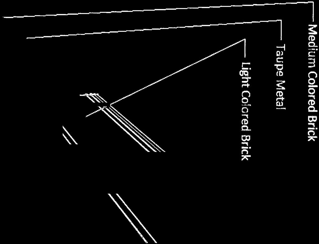

67
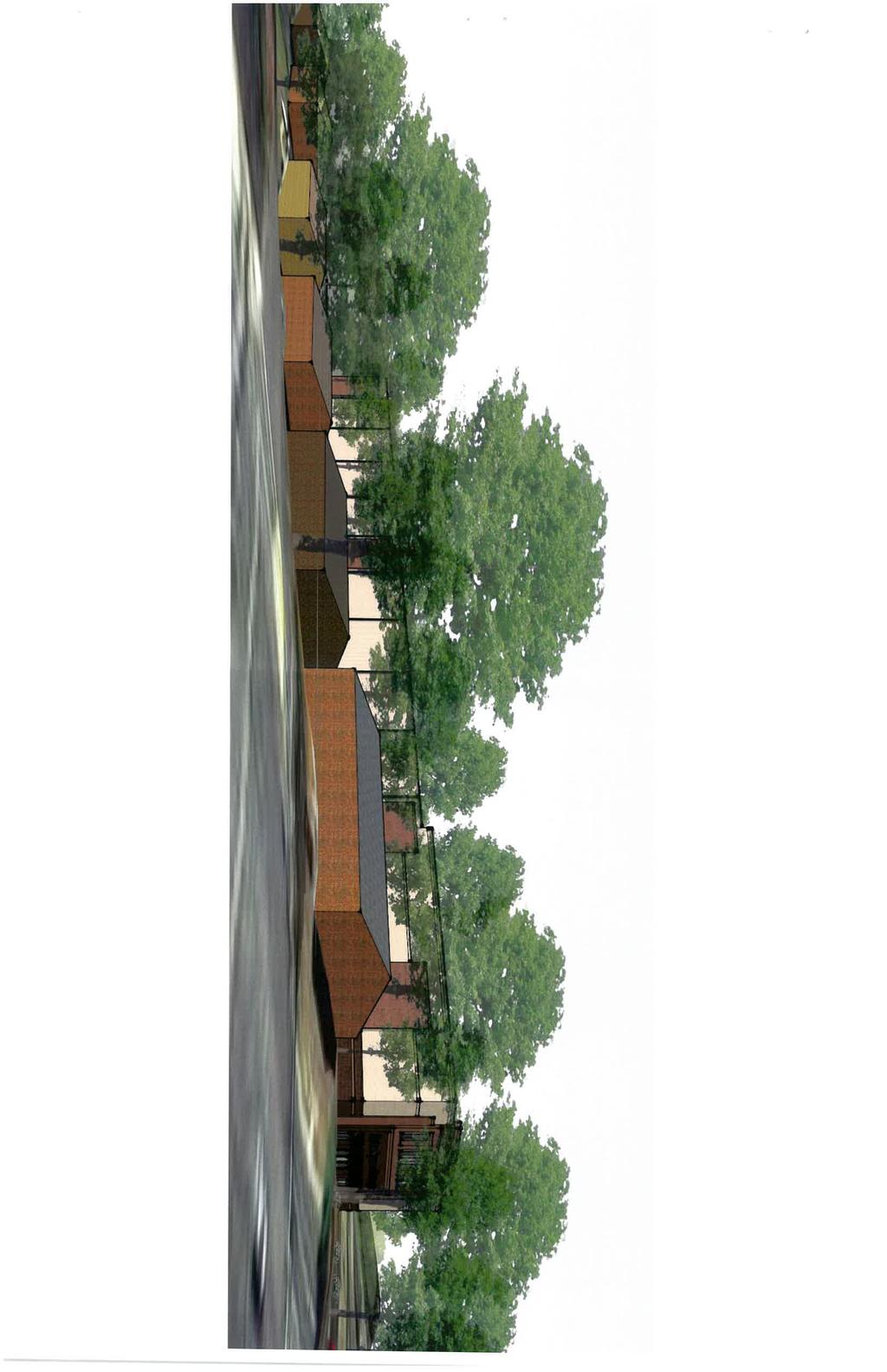
68

69 PRELIMINARY SITE DEVELOPMENT PLAN FOR EXTRA SPACE - HYDRAULIC ROAD LEGEND EXIST NEW DESCRIPTION TAX MAP 40C, PARCEL 46 CITY OF CHARLOTTESVILLE, VIRGINIA VICINITY MAP SCALE: 1"=500' OWNER FIRE MARSHALL'S NOTES DEVELOPER SITE Hydraulic Rd. U.S. RT 29 - Seminole Trail ZONING LEGAL REFERENCE BENCHMARK T JUSTIN M. SHIMP Lic. No FOR REVIEW SOURCE OF BOUNDARY & TOPO SHEET INDEX SHEET C1 - COVER SHEET SHEET C2 - EXISTING CONDITIONS & DEMOLITION PLAN SHEET C3 - SITE PLAN SHEET C4 - GRADING & UTILITY PLAN SHEET C5 - LANDSCAPING PLAN SHEET C6 - SIGHT DISTANCE DETAILS SHEET C7 - SITE & UTILITY DETAILS NOTES BUILDING HEIGHT SETBACKS EXISTING USE PROPOSED USE LAND USE SCHEDULE CRITICAL SLOPES LIGHTING FLOOD ZONE CITY PERMITS WATER & SANITARY SERVICES ELECTRIC / TELEPHONE / CABLE TV SIGNS PARKING SCHEDULE APPROVALS: DIRECTOR OF NEIGHBORHOOD DEVELOPMENT SERVICES DATE
70 T JUSTIN M. SHIMP Lic. No FOR REVIEW
71 T JUSTIN M. SHIMP Lic. No FOR REVIEW
72 T JUSTIN M. SHIMP Lic. No FOR REVIEW
73 T JUSTIN M. SHIMP Lic. No FOR REVIEW NOTE: 1. THE LAND OWNER SHALL BE PERMANENTLY RESPONSIBLE FOR MAINTENANCE OF ALL STREET TREES.
74 T JUSTIN M. SHIMP Lic. No FOR REVIEW


75 T W E I V E Lic. R No R JUSTIN M. SHIMP FO SEE PLANS FOR EXACT LAYOUT. SPACE PLANTS AS SPECIFIED IN PLANT LIST OR AS SHOWN. ADJUST SPACING AS NECESSARY OR AS DIRECTED BY LANDSCAPE ARCHITECT. SET SHRUB PLUMB. TOP OF ROOTBALL SHALL NOT BE MORE THAN 1" ABOVE FINISHED GRADE MULCH 2" DEEP IMMEDIATELY AFTER PLANTING AND WATER THOROUGHLY. REMOVE BURLAP FROM TOP 1/3 OF ROOTBALL 3" TALL WATERING BERM PLANTING PIT. PREPARED SOIL FOR SHRUBS 1/2 BALL DIA. MIN SOIL SURFACE ROUGHENED TO BIND NEW SOIL VARIES FINISHED GRADE
REGULAR MEETING OF LURAY PLANNING COMMISSION APRIL 13, 2016
 REGULAR MEETING OF LURAY PLANNING COMMISSION The Luray Planning Commission met on Wednesday, April 13, 2016 at 7:00 p.m. in regular session. The meeting was held in the Luray Town Council Chambers at 45
Boise City Planning & Zoning Commission Minutes November 3, 2014 Page 1
 Page 1 PUD14-00020 / 2 NORTH HOMES, LLC Location: 2818 W. Madison Avenue CONDITIONAL USE PERMIT FOR A FOUR UNIT PLANNED RESIDENTIAL DEVELOPMENT ON 0.28 ACRES LOCATED AT 2818 & 2836 W. MADISON AVENUE IN
We contacted all RNOs in the area to come to their meetings and personally explain the draft, and take questions. Four RNOs took us up on the offer,
 1 2 3 At the last TTF meeting at the end of April, the TTF reached a consensus recommendation on the draft zoning and directed staff to put it out in a draft for public review and feedback. I m going to
Charlottesville Planning Commission, Neighborhood Associations & News Media
 CITY OF CHARLOTTESVILLE A World Class City Department of Neighborhood Development Services City Hall Post Office Box 911 Charlottesville, Virginia 22902 Telephone 434-970-3182 Fax 434-970-3359 www.charlottesville.org
PENINSULA TOWNSHIP PLANNING COMMISSION MINUTES Center Road Traverse City, MI (Township Hall) February 27, :30 pm - amended time
 February 27, :30 pm - amended time") Meeting called to order at 5:30 pm by Couture. PENINSULA TOWNSHIP PLANNING COMMISSION MINUTES 13235 Center Road Traverse City, MI 49686 (Township Hall) February 27, 2017 5:30 pm - amended time Present:
Meeting called to order at 5:30 pm by Couture. PENINSULA TOWNSHIP PLANNING COMMISSION MINUTES 13235 Center Road Traverse City, MI 49686 (Township Hall) February 27, 2017 5:30 pm - amended time Present:
URBANDALE PLANNING AND ZONING COMMISSION MINUTES. November 2, 2015
 URBANDALE PLANNING AND ZONING COMMISSION MINUTES The Urbandale Planning and Zoning Commission met in regular session on Monday,, at the Urbandale City Hall, 3600 86 th Street. Chairperson Julie Roethler
TOWN OF HARRISBURG, NORTH CAROLINA BOARD of ADJUSTMENT MEETING TUESDAY, JANUARY 19, :00 PM MINUTES
 TOWN OF HARRISBURG, NORTH CAROLINA BOARD of ADJUSTMENT MEETING TUESDAY, JANUARY 19, 2016 6:00 PM MINUTES 1. CALL TO ORDER called the meeting to order. PRESENT:, John Overcash, Mike Hamamgian,, Thelma Thorne-Chapman,
City of Lake Elmo Planning Commission Meeting Minutes of January 14, 2013
 City of Lake Elmo Planning Commission Meeting Minutes of January 14, 2013 Chairman Williams called to order the workshop of the Lake Elmo Planning Commission at 7:00pm COMMISSIONERS PRESENT: Fliflet, Obermueller,
Table of Contents. Concept Plan Overview. Statement of Compliance with Design Guidelines. Statement of Compliance with Comprehensive Plan
 Table of Contents Concept Plan Overview Statement of Compliance with Design Guidelines Statement of Compliance with Comprehensive Plan Developer s Program Market Objective Benefit to Local Businesses Benefit
Subdivision FAQ s. Prepared by the Sitka Planning Office, Sara Russell, Planning Assistant Wells Williams, Planning Director
 Subdivision FAQ s Prepared by the Sitka Planning Office, 747-1814 Sara Russell, Planning Assistant Wells Williams, Planning Director Outline of Questions Answered on the following Pages - What defines
TOWN OF DUCK PLANNING BOARD REGULAR MEETING. October 9, The Planning Board for the Town of Duck convened at the Duck Meeting Hall on Wednesday,
 TOWN OF DUCK PLANNING BOARD REGULAR MEETING October 9, 2013 The Planning Board for the Town of Duck convened at the Duck Meeting Hall on Wednesday, October 9, 2013. Present were: Chair Joe Blakaitis, Vice
PLANNING COMMISSION MEETING
 03-13-08: Page 1 of 5 PLANNING COMMISSION MEETING March 13, 2008 The Planning Commission convened in Courtroom No. 1 at City Hall for their regular meeting. Chairman Fitzgerald called the meeting to order
BOARD OF ZONING APPEALS MINUTES OF THE PROCEEDINGS OF THE PUBLIC HEARING FEBRUARY 27, 2018
 BOARD OF ZONING APPEALS MINUTES OF THE PROCEEDINGS OF THE PUBLIC HEARING FEBRUARY 27, 2018 The hearing was called to order at 7:30 P.M. by Chairman Jones PRESENT: ABSENT: ALSO PRESENT: Board Members Matthew
MINUTES OF THE WORK STUDY MEETING OF THE QUEEN CREEK PLANNING AND ZONING COMMISSION AGENDA
 November 14, 2012, Page 1 of 5 MINUTES OF THE WORK STUDY MEETING OF THE QUEEN CREEK PLANNING AND ZONING COMMISSION WHEN: WEDNESDAY, NOVEMBER 14, 2012 WHERE: TOWN HALL COUNCIL CHAMBERS TIME: 6:00 p.m. Pursuant
DEVELOPMENT DEPARTMENT STAFF REPORT STAFF REPORT DRESDEN DRIVE TOWNHOMES DCI
 DEVELOPMENT DEPARTMENT STAFF REPORT Meeting Date: September 13, 2018 Item #: PZ2018-319 STAFF REPORT DRESDEN DRIVE TOWNHOMES DCI Request: Project Name: Development of Community Compact (DCI) and six concurrent
WEST BOUNTIFUL PLANNING COMMISSION
 Mayor Kenneth Romney City Engineer/ Zoning Administrator Ben White City Recorder Cathy Brightwell WEST BOUNTIFUL PLANNING COMMISSION 550 North 800 West West Bountiful, Utah 84087 Phone (801) 292-4486 FAX
ADA TOWNSHIP PLANNING COMMISSION MINUTES OF THE JUNE 15, 2017 MEETING
 ADA TOWNSHIP PLANNING COMMISSION MINUTES OF THE JUNE 15, 2017 MEETING A meeting of the was held on Thursday, June 15, 2017, 7:00 p.m. at the Ada Township Offices, 7330 Thornapple River Dr., Ada, MI. I.
TOWN OF NEW LONDON, NEW HAMPSHIRE
 TOWN OF NEW LONDON, NEW HAMPSHIRE 375 MAIN STREET NEW LONDON, NH 03257 WWW.NL-NH.COM ZONING BOARD OF ADJUSTMENT MEETING MINUTES Thursday, July 20, 2017 Town Office Sydney Crook Conference Room 375 Main
Town of Bayfield Planning Commission Meeting September 8, US Highway 160B Bayfield, CO 81122
 Planning Commissioners Present: Bob McGraw (Chairman), Ed Morlan (Vice-Chairman), Dr. Rick K. Smith (Mayor), Dan Ford (Town Board Member), Gabe Candelaria, Michelle Nelson Planning Commissioners Absent:
PLANNING COMMISSION MINUTES - CITY OF INVER GROVE HEIGHTS. Tuesday, May 20, :00 p.m. City Hall Chambers Barbara Avenue
 PLANNING COMMISSION MINUTES - CITY OF INVER GROVE HEIGHTS Tuesday, 7:00 p.m. City Hall Chambers - 8150 Barbara Avenue Chair Hark called the Planning Commission meeting to order at 7:00 p.m. Commissioners
CITY OF ANN ARBOR, MICHIGAN
 CITY OF ANN ARBOR, MICHIGAN 100 North Fifth Avenue, P.O. Box 8647, Ann Arbor, Michigan 48107-8647 www.a2gov.org Administration (734)794-6210 Community Development Services (734) 622-9025 Parks & Recreation
City of Pass Christian Municipal Complex Auditorium 105 Hiern Avenue. Zoning Board of Adjustments Meeting Minutes Tuesday, July 11, 2017, 6pm
 1 2 3 4 5 6 7 8 9 10 11 12 13 14 15 16 17 18 19 20 21 22 23 24 25 26 27 28 29 30 31 32 33 34 35 36 37 38 39 40 41 42 43 44 45 46 47 48 49 50 51 City of Pass Christian Municipal Complex Auditorium 105 Hiern
NOTICE OF MEETING The City of Lake Elmo Planning Commission will conduct a meeting on Monday December 10, 2018 at 7:00 p.m. AGENDA
 3800 Laverne Avenue North Lake Elmo, MN 55042 (651) 747-3900 www.lakeelmo.org NOTICE OF MEETING The City of Lake Elmo Planning Commission will conduct a meeting on Monday December 10, 2018 at 7:00 p.m.
THE AREA PLAN COMMISSION OF ST. JOSEPH COUNTY, IN AGENDA
 THE AREA PLAN COMMISSION OF ST. JOSEPH COUNTY, IN AGENDA Tuesday, June 20, 2017 Fourth-Floor Council Chambers 3:30 p.m. County-City Building, South Bend, IN PUBLIC HEARINGS: 1. Rezonings: A. A combined
College Avenue. Sowers Street. Calder Way. Beaver Avenue
 K L M Illustrative Master Plan: Collegiate District Calder Way Beaver Avenue High Street ner 16 Sowers Street Stre et 17 Hetzel Street 18 Gar Heister Street 15 Collegiate District 183 4-C: East End Collegiate
ANOKA PLANNING COMMISSION REGULAR MEETING ANOKA CITY HALL TUESDAY, MAY 16, :00 P.M.
 ANOKA PLANNING COMMISSION REGULAR MEETING ANOKA CITY HALL TUESDAY, MAY 16, 2017 7:00 P.M. CALL TO ORDER: The regular meeting of the Anoka Planning Commission was called to order at 7:00 p.m. ROLL CALL:
Planned Residence District (PR) To review a plan to construct 11 single family homes on approximately 4.01 acres.
 To review a plan to construct 11 single family homes on approximately 4.01 acres.") STAFF REPORT PLANNING & ZONING COMMISSION Village Green Municipal Building, Council Chambers 47 Hall Street Wednesday, March 13, 2019 7:00 P.M. 1. FINAL DEVELOPMENT PLAN REVIEW Applicant: Romanelli and
STAFF REPORT PLANNING & ZONING COMMISSION Village Green Municipal Building, Council Chambers 47 Hall Street Wednesday, March 13, 2019 7:00 P.M. 1. FINAL DEVELOPMENT PLAN REVIEW Applicant: Romanelli and
AMERICAN FORK CITY PLANNING COMMISSION MINUTES MARCH 16, 2016
 AMERICAN FORK CITY PLANNING COMMISSION MINUTES MARCH 16, 2016 The American Fork Planning Commission met in a regular session on March 16, 2016, in the American Fork City Hall, located at 31 North Church
JUNE 25, 2015 BUTTE-SILVER BOW PLANNING BOARD COUNCIL CHAMBERS BUTTE, MONTANA MINUTES
 JUNE 25, 2015 BUTTE-SILVER BOW PLANNING BOARD COUNCIL CHAMBERS BUTTE, MONTANA Members Present: Absent: Staff: Janet Lindh, Dan Foley, Rick LaBreche, Marc Murphy, Mike Kerns and John Taras Michael Marcum,
learning.com Streets In Infinity Streets Infinity with many thanks to those who came before who contributed to this lesson
 www.lockhart- learning.com Streets In Infinity 1 Streets in Infinity with many thanks to those who came before who contributed to this lesson 2 www.lockhart- learning.com Streets in Infinity Materials
Composition of traditional residential corridors.
 Page 1 of 7 St. Petersburg, Florida, Code of Ordinances >> PART II - ST. PETERSBURG CITY CODE >> Chapter 16 - LAND DEVELOPMENT REGULATIONS >> SECTION 16.20.060. CORRIDOR RESIDENTIAL TRADITIONAL DISTRICTS
Appendix C Tips for Making an Inspection a Cooperative Rather Than an Adversarial Experience
 Appendix C Tips for Making an Inspection a Cooperative Rather Than an Adversarial Experience A strongly expressed desire by the vocational educational program administrators, as well as by the enforcing
Staff presented two options for the Commission to consider recommending to Town Council:
 Attendance: Chair Darrell Page; Commissioners: Ann Holland, Scott Burroughs, Steve Clark, Pam Barger, Pam Carter, Michael Aldridge (arrived at 7:39); Hilda Keeney, Planning and Zoning Clerk; Kassie Watts,
Village of Bellevue Plan Commission
 Village of Bellevue Plan Commission Pursuant to Section 19.84 Wis. Stats., a scheduled regular meeting of the Village of Bellevue Plan Commission was held on Tuesday, at 7:00 p.m. at the Bellevue Village
ROSEMEAD CITY COUNCIL STAFF REPORT
 ROSEMEAD CITY COUNCIL STAFF REPORT TO THE HONORABLE MAYOR AND CITY COUNCIL FROM JEFF ALLRED CITY MANAGER DATE JUNE 9 2015 6 SUBJECT MUNICIPAL CODE AMENDMENT 15 02 AMENDING CHAPTERS 17 04 AND 17 72 OF TITLE
Community Dev. Coord./Deputy City Recorder
 1 2 3 4 5 6 7 8 9 10 11 12 13 14 15 16 17 18 19 20 21 22 23 24 25 26 27 28 29 30 31 32 33 34 35 36 37 38 39 40 41 42 43 44 45 46 NORTH OGDEN PLANNING COMMISSION MEETING MINUTES December 18, 2013 The North
Staff Report: Date: Applicant: Property Identification: Acreage of Request: Current Zoning of Requested Area: Requested Action: Attached:
 Staff Report: Completed by Jeff Palmer Director of Planning & Zoning Date: November 7, 2018, Updated November 20, 2018 Applicant: Greg Smith, Oberer Land Developer agent for Ronald Montgomery ET AL Property
ALPINE TOWNSHIP PLANNING COMMISSION REGULAR MEETING June 15, 2017
 Page 1 of 6 ALPINE TOWNSHIP PLANNING COMMISSION REGULAR MEETING 17-26 CALL TO ORDER / APPROVAL OF THE REGULAR MEETING MINUTES OF MAY 18, 2017 AND THE / PUBLIC COMMENT ON NON-AGENDA ITEMS The Alpine Township
Sell Your House in DAYS Instead of Months
 Sell Your House in DAYS Instead of Months No Agents No Fees No Commissions No Hassle Learn the secret of selling your house in days instead of months If you re trying to sell your house, you may not have
TOWN OF WARWICK ZONING BOARD OF APPEALS FEBRUARY 22, 2010
 TOWN OF WARWICK ZONING BOARD OF APPEALS FEBRUARY 22, 2010 Members Present: Mr. Jan Jansen, Chairman Mr. Mark Malocsay, Co-Chairman Mr. Norm Paulsen Attorney Robert Fink Members Absent: Diane Bramich Chairman
Evolution of the Vision for NE 181st Street Study Area
 City Council Action on NE 181 St Street Study Area Evolution of the Vision for NE 181st Street Study Area such uses to ensure neighborhood compatibility. More intense uses may be allowed through a conditional
Gary Locke, Plans Administrator Eric Fink, Asst. Law Director Jennifer Barone, Development Engineer Sheila Uzl, Transcriptionist
 KENT PLANNING COMMISSION REGULAR BUSINESS MEETING MEMBERS PRESENT: EXCUSED: STAFF PRESENT: Matt VanNote Bill Anderson Dave Wise Sean Kaine John Gargan Gary Locke, Plans Administrator Eric Fink, Asst. Law
City of Reno October 30, 2012 Draft Midtown Zoning Text Amendments 1
 Section 18.08.405 Regional Center and Transit Corridor Overlay Districts (i) SVTC South Virginia Street Transit Corridor Overlay Zoning District. (1) Applicability. This Section 18.08.405(l)'s standards
Ann Arbor Downtown Zoning Evaluation
 Ann Arbor Downtown Zoning Evaluation Options Workbook ENP & Associates in cooperation with the City of Ann Arbor September, 2013 Photo Courtesy of Andrew Horne, February 9, 2013 Introduction Thank you
Cascade Charter Township, Zoning Board of Appeals Minutes July 14, 2015 Page 1
 ZONING MINUTES Cascade Charter Township Zoning Board of Appeals Tuesday, July 14, 2015 7:00 P.M. Cascade Library Wisner Center 2870 Jackson Avenue SE ARTICLE 1. ARTICLE 2. ARTICLE 3. Chairman Casey called
NOTICE OF MEETING AND AGENDA FOR THE PLANNING COMMISSION OF SPRINGVILLE, UTAH... JANUARY 23, 2018
 NOTICE OF MEETING AND AGENDA FOR THE PLANNING COMMISSION OF SPRINGVILLE, UTAH............................ JANUARY 23, 2018 Notice is hereby given that the Planning Commission will hold a public meeting
TOWN OF MOUNT PLEASANT, SOUTH CAROLINA BOARD OF ZONING APPEALS FEBRUARY 22, 2010 MINUTES
 TOWN OF MOUNT PLEASANT, SOUTH CAROLINA BOARD OF ZONING APPEALS FEBRUARY 22, 2010 MINUTES Present: Absent: Staff: Charles Moore, chair, Don Gwinnup, Robert Hollings, Saila Smyly, Mason Smith Ann Dovre-Coker
Audio #26 NRAS NRAS
 NRAS Dymphna: Welcome everybody to iloverealestate.tv. Great to have you guys listening again and once again, I have a fabulous guest speaker to come and talk to you. Now we re talking about something
1 P a g e T o w n o f W a p p i n g e r Z B A M i n u t e MINUTES
 1 P a g e T o w n o f W a p p i n g e r Z B A M i n u t e 0 5-09- 17 MINUTES Town of Wappinger Zoning Board of Appeals May 9, 2017 Time: 7:00PM Town Hall 20 Middlebush Road Wappinger Falls, NY Summarized
PUBLIC REVIEW MEETING
 Douglas S. Wright, Jr., chair, opened the meeting at 7:01 p.m., on Wednesday, September 26, 2018, in the Council Chamber, Second Floor, City Hall. Also present were commission members S. McIntire, J. Stone,
WAYZATA PLANNING COMMISSION MEETING MINUTES MAY 21, AGENDA ITEM 1. Call to Order and Roll Call
 PC00-0 0 0 0 WAYZATA PLANNING COMMISSION MEETING MINUTES MAY, 0 AGENDA ITEM. Call to Order and Roll Call Chair Buchanan called the meeting to order at :00 p.m. Present at roll call were Commissioners:
Unless the City is going to enforce this, including the collection of taxes, it should be removed from the Code
 DIVISION 20 - PAG PASS-A-GRILLE ZONING DISTRICT Page Line Comment Response/Resolution Sec 20.01 Purpose and intent. 2 2 5 The proposed PAG Overlay is intended to prevent the construction of more residential
Minutes. Village Planning Board. March 23, 2004
 Minutes March 23, 2004 A meeting of the Village of Horseheads Planning Board was held on the above date at 6:00 p.m. Present were Chairman Bob Skebey, Board Members,,, and, Alternate Members Denis Kingsley
Jasper 115 Street DC2 Urban Design Brief
 Jasper 115 Street DC2 Urban Design Brief Greenlong Construction Ltd. Stantec Consulting Ltd. 2017 Overview The proposed rezoning application supports the development of two mixed-use high-rise buildings
Bolton Zoning Board of Appeals Regular Meeting Minutes June
 Bolton Zoning Board of Appeals Regular Meeting Minutes June 10 2014 Present at the meeting were: Mark Altermatt, John Toomey, Joel Hoffman, Jon Treat, Morris Silverstein, Bob Peterson and Jim Rupert, Zoning
In Business Q and A. Todd Nigro, president of Nigro Development. December 24 December 30, 2004 Interviewed by Jennifer Shubinski / Staff Writer
 In Business Q and A Todd Nigro, president of Nigro Development December 24 December 30, 2004 Interviewed by Jennifer Shubinski / Staff Writer Nigro Development is a small company with big plans for the
TOWN OF WARWICK ZONING BOARD OF APPEALS MAY 29, 2012
 TOWN OF WARWICK ZONING BOARD OF APPEALS MAY 29, 2012 Members Present: Jan Jansen, Chairman Mark Malocsay, Co-Chairman Diane Bramich Attorney Robert Fink Norman Paulsen Kevin Shuback minutes from the meeting
Meeting Announcement and Agenda Mt. Pleasant Zoning Board of Appeals. Wednesday, April 25, :00 p.m. City Hall Commission Chamber
 Meeting Announcement and Agenda Mt. Pleasant Zoning Board of Appeals Wednesday, April 25, 2018-7:00 p.m. City Hall Commission Chamber I. Roll Call: Assmann, Berkshire, Friedrich, Orlik, Raisanen, White
How To Organize a Tenants' Association
 How To Organize a Tenants' Association Before You Begin Once again: * you have no heat and hot water. * the building's front door lock is broken, and a neighbor was mugged in the lobby. * you asked the
38 th & Blake Height Amendments: Public Meeting #5 Building Design Comments July 13 th, 2016
 38 th & Blake Height Amendments: Public Meeting #5 Building Design Comments July 13 th, 2016 Table 1 1. Require people-oriented ground floors 2. Preserve sunlight, views, and architectural variety 3. Treat
PLANNED DEVELOPMENT DISTRICT STANDARDS. Cadence Site
 PLANNED DEVELOPMENT DISTRICT STANDARDS Cadence Site A Planned Development District 1. Statement of General Facts, Conditions and Objectives Property Size: Approximately 57.51 Acres York County Tax Map
STAFF PRESENT: Community Development Director: Nathan Crane Secretary: Dorinda King
 1 0 1 0 1 Highland City Planning Commission April, The regular meeting of the Highland City Planning Commission was called to order by Planning Commission Chair, Christopher Kemp, at :00 p.m. on April,.
Charter Township of Lyon. Planning Commission. Meeting Minutes. September 13, 2010
 Charter Township of Lyon Planning Commission Meeting Minutes September 13, 2010 The meeting was called to order by Mr. O Neil at 7:00 p.m. Approved: September 27, 2010, as corrected Roll Call: Lise Blades
Together with Tenants
 Together with Tenants Our draft plan Your feedback needed by 19 April 20 February 2019 About this plan The National Housing Federation is the membership body for housing associations in England. Our housing
AGENDA. CITY OF CENTRALIA, MISSOURI Planning and Zoning Commission Thursday, April 21, :00 P.M. City Hall Council Chambers
 AGENDA CITY OF CENTRALIA, MISSOURI Planning and Zoning Commission Thursday, April 21, 2016 6:00 P.M. City Hall Council Chambers I. ROLL CALL II. III. IV. Pledge of Allegiance Approval of Minutes of Previous
CITY OF WEST PARK PROPOSED TRANSIT ORIENTED CORRIDOR (TOC) EXPANSION WORKSHOP JUNE 15, 2016 FREQUENTLY ASKED QUESTIONS (FAQ)
 EXPANSION WORKSHOP JUNE 15, 2016 FREQUENTLY ASKED QUESTIONS (FAQ)") CITY OF WEST PARK PROPOSED TRANSIT ORIENTED CORRIDOR (TOC) EXPANSION WORKSHOP JUNE 15, 2016 FREQUENTLY ASKED QUESTIONS (FAQ) Q: Have you considered that people here love driving their cars and trucks,
CITY OF WEST PARK PROPOSED TRANSIT ORIENTED CORRIDOR (TOC) EXPANSION WORKSHOP JUNE 15, 2016 FREQUENTLY ASKED QUESTIONS (FAQ) Q: Have you considered that people here love driving their cars and trucks,
HARRIS TOWNSHIP Planning Commission Meeting Minutes September 19, 2016
 HARRIS TOWNSHIP Planning Commission Meeting Minutes September 19, 2016 Members in Attendance: Staff in Attendance: Public in Attendance: Bob Igo, Chairman Jeff Duerr, Vice Chairman Ron Buckalew John Wainright
Mayor Donovan Trustee Cronk Trustee Brazill Trustee Champagne Trustee Theobald Attorney Primo Clerk/Treasurer Snider
 October 15, 2007 DISTRIBUTION LIST Richard Donovan, Mayor Edmond Theobald, Trustee Ronald Cronk, Trustee William Brazill, Trustee John Champagne, Trustee Steven Primo, Attorney Thomas Petterelli, DPW Superintendent
ARLINGTON COUNTY, VIRGINIA
 ARLINGTON COUNTY, VIRGINIA County Board Agenda Item Meeting of April 19, 2008 DATE: April 2, 2008 SUBJECT: ORDINANCE TO AMEND, REENACT, AND RECODIFY Section 20 CP- FBC, Columbia Pike Form Based Code Districts
550 North 800 West West Bountiful, Utah Phone (801) FAX (801) PLANNING COMMISSION MEETING
 FAX (801) PLANNING COMMISSION MEETING") Mayor Kenneth Romney City Council James Ahlstrom James Bruhn Kelly Enquist Debbie McKean Mark Preece WEST BOUNTIFUL CITY 550 North 800 West West Bountiful, Utah 84087 Phone (801) 292-4486 FAX (801) 292-6355
Mayor Kenneth Romney City Council James Ahlstrom James Bruhn Kelly Enquist Debbie McKean Mark Preece WEST BOUNTIFUL CITY 550 North 800 West West Bountiful, Utah 84087 Phone (801) 292-4486 FAX (801) 292-6355
CITY OF CHARLOTTESVILLE DEPARTMENT OF NEIGHBORHOOD DEVELOPMENT SERVICES STAFF REPORT
 CITY OF CHARLOTTESVILLE DEPARTMENT OF NEIGHBORHOOD DEVELOPMENT SERVICES STAFF REPORT UPDATE: REQUEST FOR A ZONING TEXT AMENDMENT ZT15 00007: WEST MAIN STREET MIXED USE CORRIODRS AMENDMENT PLANNING COMMISSION
Chairman Byrne called the meeting to order at 6:00 p.m. and noted a quorum was present.
 CITY OF LEAVENWORTH PLANNING COMMISSION COMMISSION CHAMBERS, CITY HALL 100 N 5 th Street, Leavenworth, Kansas 66048 REGULAR SESSION Monday, January 7, 2019 6:00 PM CALL TO ORDER: Commissioners Present
TOWN OF ULYSSES PLANNING BOARD MEETING MINUTES Tuesday, February 6, 2018
 TOWN OF ULYSSES PLANNING BOARD MEETING MINUTES Tuesday, Approved: February 20, 2018 Present: Chair David Blake, and board members Rebecca Schneider, John Wertis and alternate Benjamin LeWalter; Town Planner
The Zoning Committee voted 4-2 to APPROVE this petition.
 Rezoning Petition 2016-T001 Zoning Committee Recommendation August 9, 2016 REQUEST SUMMARY OF PETITION PETITIONER AGENT/REPRESENTATIVE COMMUNITY MEETING STATEMENT OF CONSISTENCY Text amendment to Sections
The State of North Broad
 Welcome to the second issue of our monthly newsletter for Stamm Development Group. The targeted markets where we focus continue to be vibrant. We are seeing a lot of interest in the general areas of our
Approval of Amendment to City Code Chapter 34 (Zoning) Read Brodhead, Zoning Administrator of the City of Charlottesville
 Read Brodhead, Zoning Administrator of the City of Charlottesville") CITY OF CHARLOTTESVILLE, VIRGINIA CITY COUNCIL AGENDA Agenda Date: April 15, 2013 Action Required: Presenter: Staff Contacts: Approval of Amendment to City Code Chapter 34 (Zoning) Read Brodhead, Zoning
CITY OF CHARLOTTESVILLE, VIRGINIA CITY COUNCIL AGENDA Agenda Date: April 15, 2013 Action Required: Presenter: Staff Contacts: Approval of Amendment to City Code Chapter 34 (Zoning) Read Brodhead, Zoning
AGENDA SLOT HOME EVALUATION & TEXT AMENDMENT. 5:30 - Welcome
 AGENDA 5:30 - Welcome Please sign-in, put a sticker on the map, grab snacks, materials and a seat 5:45 - Staff Presentation 6:15 - Open House Stations Background Information Mixed Use Districts Multi Unit
Members present: Burchill, Yacoub, Yoerg, Potter, Rhoades and Casanova
 PLAN COMMISSION Members present: Burchill, Yacoub, Yoerg, Potter, Rhoades and Casanova Others present: Richard Stout, Tim and Betty Caruso, Jim Zeller, Jennifer O Neill, Matt Frisbie, Alan Catchpool, Jeff
Goal 1 - Retain and enhance Cherry Creek North s unique physical character.
 Introduction This document summarizes the proposed new zoning for the area of roughly bordered by University Boulevard, Steele Street, 3rd Avenue, and 1st Avenue. It provides a high-level review of the
CITY OF MANHATTAN BEACH [DRAFT] PLANNING COMMISION MINUTES OF REGULAR MEETING JANUARY 28, 2015
![CITY OF MANHATTAN BEACH [DRAFT] PLANNING COMMISION MINUTES OF REGULAR MEETING JANUARY 28, 2015](/thumbs/94/121103169.jpg "CITY OF MANHATTAN BEACH [DRAFT] PLANNING COMMISION MINUTES OF REGULAR MEETING JANUARY 28, 2015") CITY OF MANHATTAN BEACH [DRAFT] PLANNING COMMISION MINUTES OF REGULAR MEETING JANUARY 28, 2015 A Regular Meeting of the Planning Commission of the City of Manhattan Beach, California, was held on the 28
CITY OF MANHATTAN BEACH [DRAFT] PLANNING COMMISION MINUTES OF REGULAR MEETING JANUARY 28, 2015 A Regular Meeting of the Planning Commission of the City of Manhattan Beach, California, was held on the 28
Staff Report PLANNED DEVELOPMENT. Salt Lake City Planning Commission. From: Lauren Parisi, Associate Planner; Date: December 14, 2016
 Staff Report PLANNING DIVISION COMMUNITY & NEIGHBORHOODS To: Salt Lake City Planning Commission From: Lauren Parisi, Associate Planner; 801-535-7932 Date: December 14, 2016 Re: 1611 South 1600 East PLANNED
MINUTES of the Vernal City PLANNING COMMISSION Vernal City Council Chambers 447 East Main Street August 13, 2009
 MINUTES of the Vernal City PLANNING COMMISSION Vernal City Council Chambers 447 East Main Street Members Present: Freida Parker, Shirley Wilkins, Gordon Seitz, Eric Olsen, Sonja Norton, Troy Allred Alternates
Agenda. PLANNING COMMISSION REGULAR DOCKET TUESDAY, February 9, :30 P.M. CITY COUNCIL CHAMBERS
 Agenda PLANNING COMMISSION REGULAR DOCKET TUESDAY, February 9, 2016 5:30 P.M. CITY COUNCIL CHAMBERS I. PLANNING COMMISSION GATHERING -- 4:30 P.M. (Held in the NDS Conference Room) Commissioners gather
Zoning Board of Appeals
 Zoning Board of Appeals Minutes (meeting taped) Monthly meeting: Thursday, July 15, 2010 in the City Hall Aldermanic Chambers. The meeting was called to order at 6:35 p.m. Without objection the chair called
SESSION #3 Zoning Code Definitions
 SESSION #3 Zoning Code Definitions Purpose The purpose of this review is to evaluate the various definitions of uses and related items addressed in the zoning code. While the zoning code does not define
2015 Planning and Zoning School Town of Hyde Park July 15, Site Plan Review and Special Use Permits
 2015 Planning and Zoning School Town of Hyde Park July 15, 2015 Site Plan Review and Special Use Permits Matthew G. Rogers, AICP New York Planning Federation Introduction Site Plan and Special Use Permits
1. Roll Call. 2. Minutes a. September 24, 2018 Special Joint Meeting with Clay County Planning Commission. 3. Adoption of the Agenda
 1. Roll Call City of Vermillion Planning Commission Agenda 5:30 p.m. Regular Meeting Tuesday, October 9, 2018 City Council Chambers 2 nd Floor City Hall 25 Center Street Vermillion, SD 57069 2. Minutes
PLAINFIELD CHARTER TOWNSHIP COMMUNITY DEVELOPMENT DEPARTMENT PLANNING, ZONING & BUILDING SERVICES MEMORANDUM
 PLAINFIELD CHARTER TOWNSHIP COMMUNITY DEVELOPMENT DEPARTMENT PLANNING, ZONING & BUILDING SERVICES 6161 BELMONT AVENUE N.E. BELMONT, MI 49306 PHONE 616-364-1190 FAX: 616-364-1170 www.plainfieldchartertwp.org
RICHMOND CITY PLANNING & ZONING COMMISSION City Council Chambers 6 West Main Street Richmond, Utah 84333
 RICHMOND CITY PLANNING & ZONING COMMISSION City Council Chambers 6 West Main Street Richmond, Utah 84333 The Richmond City Planning & Zoning Commission met in the City Council Chambers, 6 West Main Street,
Constance Bakall Request for Return of Escrow Balance Mr. Merante asked Mr. Gainer if there was anything outstanding.
 Philipstown Planning Board Meeting Minutes May 19, 2011 The Philipstown Planning Board held its regular monthly meeting on Thursday, May 19, 2011 at the VFW Hall on Kemble Avenue in Cold Spring, New York.
City of Lake Elmo Planning Commission Meeting Minutes of January 26, 2015
 City of Lake Elmo Planning Commission Meeting Minutes of January 26, 2015 Chairman Williams called to order the meeting of the Lake Elmo Planning Commission at 7:00 p.m. COMMISSIONERS PRESENT: Williams,
MINUTES OF A REGULAR MEETING ZONING BOARD OF ADJUSTMENT OF THE BOROUGH OF MOUNTAIN LAKES February 24, 2016
 MINUTES OF A REGULAR MEETING ZONING BOARD OF ADJUSTMENT OF THE BOROUGH OF MOUNTAIN LAKES February 24, 2016 Chair Chris Richter called the meeting to order and announced: Adequate notice of this meeting
8.5.1 R1, Single Detached Residential District
 8.5.1 R1, Single Detached Residential District The purpose of this district is to provide for residential development in the form of single detached dwellings. Dwelling, Single Detached Home Business,
Tyrone Planning Commission Agenda May 24, :00 PM
 Tyrone Planning Commission Agenda May 24, 2018 7:00 PM Planning Commission I. Call to Order Jeff Duncan Chairman II. Approval of Agenda David Nebergall Vice-Chairman Carl Schouw Commissioner Dia Hunter
Charlottesville Planning Commission, Neighborhood Associations & News Media
 CITY OF CHARLOTTESVILLE A World Class City Department of Neighborhood Development Services City Hall Post Office Box 911 Charlottesville, Virginia 22902 Telephone 434-970-3182 Fax 434-970-3359 www.charlottesville.org
STERLING HEIGHTS PLANNING COMMISSION REGULAR MEETING CITY HALL JANUARY 9, 2014
 STERLING HEIGHTS PLANNING COMMISSION REGULAR MEETING CITY HALL JANUARY 9, 2014 LOCATION: City Council Chambers, 40555 Utica Road, Sterling Heights, MI. SUBJECT: Minutes of the Regular Meeting of the Planning
Home Buyer s Guide. Everything you need to know before buying a home
 Home Buyer s Guide Everything you need to know before buying a home A real estate transaction is one of the biggest financial transactions most people will do in a lifetime. Understanding the buying process
SUBDIVISION, PLANNED UNIT DEVELOPMENT, ZONING AMENDMENT, & SIDEWALK WAIVER STAFF REPORT Date: July 19, 2018
 SUBDIVISION, PLANNED UNIT DEVELOPMENT, ZONING AMENDMENT, & SIDEWALK WAIVER STAFF REPORT Date: July 19, 2018 NAME SUBDIVISION NAME LOCATION West Mobile Properties, LLC U.S. Machine Subdivision 556, 566,
SECOND UNIT DRAFT. workbook. A tool for homeowners considering building a second unit in San Mateo County
 DRAFT SECOND UNIT workbook A tool for homeowners considering building a second unit in San Mateo County Step 1 Getting Started This section will help you get started. By the end of the chapter you will:
DEPT. Burlington Board of Appeals DATE: Tuesday, July 17, 2018 TIME: 7:30P.M. PLACE: Town Hall Main Meeting Room, 2 nd floor
 Town of Burlington Meeting Posting DEPT. Burlington Board of Appeals DATE: Tuesday, July 17, 2018 TIME: 7:30P.M. PLACE: Town Hall Main Meeting Room, 2 nd floor Introduction of new Board Members Amendment