Halifax Regional Council May 09, 2017
|
|
|
- Martha Bond
- 5 years ago
- Views:
Transcription
1 P.O. Box 1749 Halifax, Nova Scotia B3J 3A5 Canada Item No Halifax Regional Council May 09, 2017 TO: Mayor Savage and Members of Halifax Regional Council SUBMITTED BY: Brad Anguish, A/Chief Administrative Officer DATE: March 31, 2017 SUBJECT: Case 20232: Municipal Planning Strategy and Land Use By-law amendments for 686 Bedford Highway, Halifax ORIGIN Application by W.M. Fares Architects LEGISLATIVE AUTHORITY See Attachment E RECOMMENDATION It is recommended that Halifax Regional Council refuse to initiate the process to consider amendments to the Municipal Planning Strategy for Halifax and the Land Use By-law for Halifax Mainland to enable the development of a multi-unit residential building at 686 Bedford Highway, Halifax.
2 Case 20232: MPS and LUB Amendments 686 Bedford Highway, Halifax Regional Council Report May 09, 2017 BACKGROUND W.M. Fares Architects is applying to develop a multi-unit residential building located at 686 Bedford Highway, Halifax. As this proposal cannot be considered under existing policies, the applicant is seeking amendments to the Municipal Planning Strategy for Halifax (MPS) and the Land Use By-law for Halifax Mainland (LUB) to enable the proposal. Subject site Location Regional Plan Designation Community Plan Designation (Map 1) Zoning (Map 2) Size of Site Street Frontage Current Land Use(s) Surrounding Use(s) 686 Bedford Highway, Halifax West side of Bedford Highway, approximately 200 metres south of Fern Avenue and 400 metres north of Larry Uteck Boulevard Urban Settlement Low Density Residential R-1 (Single Family Dwelling Zone) 8,779 square metres (94,500 square feet) Approximately 91 metres (300 feet), with an irregular front property line Single Unit Dwelling The property is surrounded on three sides (west side of Bedford Highway) by a single undeveloped parcel of land (Block E-R4) which is subject to a Development Agreement under the Wentworth and Bedford South Secondary Planning Strategies. This parcel is not currently eligible for development. A low-density residential neighbourhood is to the north. To the south and west, there is higher density development on Bedford Highway and Larry Uteck Boulevard. To the east lie water lots within the Bedford Basin and the CN Railway. Proposal Details The applicant wishes to develop a multi-unit residential building at 686 Bedford Highway. To enable this form of development, the applicant has requested site-specific amendments to the MPS and LUB that would allow the site to be developed by development agreement (Attachment A). MPS and LUB Context Under the MPS, 686 Bedford Highway is designated Low Density Residential within the Bedford Highway Secondary Planning Strategy (BHSPS). Policy 1.4 permits single-detached housing on low-density residential properties, and as such, the property is zoned R-1 (Single Family Dwelling). DISCUSSION The MPS is a strategic policy document that sets out the goals, objectives and direction for long term growth and development in Halifax. While the MPS provides broad direction, Regional Council may consider MPS amendment requests to enable proposed development that is inconsistent with its policies. Amendments to an MPS are significant undertakings and Council is under no obligation to consider such requests. Amendments should be only considered within the broader planning policy context and when there is reason to believe that circumstances have changed since the MPS was adopted, or last reviewed. Applicant Rationale The applicant has provided the following rationale in support of the proposed amendment(s):
3 Case 20232: MPS and LUB Amendments 686 Bedford Highway, Halifax Regional Council Report May 09, 2017 The site characteristics, including the location, the lot size and frontage, steep grades, and separation from existing uses make it appropriate for a mid-rise, multi-unit residential building; and Substantial development in the surrounding area has occurred in recent years. Attachment A contains the applicant s rationale. Staff Review Staff have reviewed the submitted rationale in the context of current policy, site circumstances and surrounding land uses and advise that there is there is not merit to the request for the following reasons: Intent of current policy As part of the Halifax Harbour Secondary Plan Initiative, the Land Use Planning Study Western Shore Bedford Basin 1 was approved-in-principle by Regional Council on February 19, The study area covered the western shore of Bedford Basin from Hogans Point to the Waterfront Development Corporation s Bedford Waterfront Phase II, and was intended to make recommendations concerning future land use of the study area. Following public consultation, this study recommended high-density development for bookends of the Bedford Highway (Bedford Waterfront and the Chinatown area), and proposed that two smaller nodes could accommodate some mixed-use development. It was recommended that areas outside of the nodes should remain low density, stating [i]t is important that continuous strip commercial developments not be permitted to take place all through the study area. The existing wooded and residential areas should continue to exist to maintain the special character of this length of Bedford Highway. The February 19, 2008 Motion of Regional Council directed staff to commence the process to amend the Bedford Highway Secondary Planning Strategy and Land Use Bylaw, using the report s recommendations as a framework. On January 11, 2011, Regional Council approved changes to the MPS and LUB which implemented the recommendations of the Land Use Planning Study Western Shore Bedford Basin. The node concept envisioned in the study was implemented through BHSPS Policies 1.8 to 1.8.3, which permit mixed-use redevelopment (with buildings exceeding 35 feet) by development agreement at two strategic locations along the Bedford Highway: the intersection with Larry Uteck Boulevard, and at the north end of the Halifax Plan Area (Attachment B). These properties are identified in the LUB as Schedule R (Attachment C and Map 3). The intent of the Schedule R policy is to limit larger mixed-use (residential/ commercial) buildings to specific areas of the Bedford Highway. Policy states that to be considered for inclusion within Schedule R, properties must have the Highway Commercial Designation, be zoned C-2B, and be immediately adjacent to lands currently under Schedule R. The subject property does not meet any of these criteria. During the approval process for Schedule R in 2011, Regional Council requested a supplementary report to address, among other things, a concern from the owner of 686 Bedford Highway that their lands should be considered for increased development opportunities as part of the amendments proposed at that time. The supplementary report 2 explained that the staff recommendation considered community concerns with multi-unit developments, coupled with the study s recommendations around preserving and promoting the corridor as a scenic drive. The report suggests that any future application should be complementary to the conclusions and general direction of the Land Use Planning Study Western Shore Bedford Basin. As the policy s intent is to limit large mixed-used development to particular areas of the Bedford Highway, staff do not recommend proceeding with the applicant s request
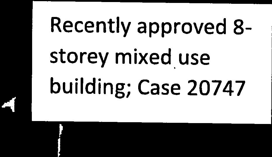
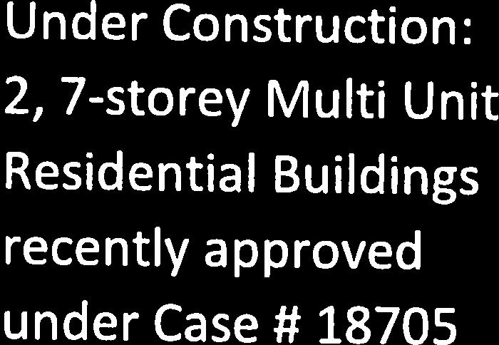
4 Case 20232: MPS and LUB Amendments 686 Bedford Highway, Halifax Regional Council Report May 09, 2017 Circumstances since current policy adoption Circumstances have not changed significantly since the MPS policy was last reviewed for the area, and changes in the development pattern have occurred only to the extent envisioned by current policy. Since the Schedule R policies were adopted in 2011, North West Community Council has approved three development agreements for multi-unit residential buildings under the policy, and one additional building is proposed. Of the approved developments, one is currently under construction and none have been completed. The multi-unit residential development west of the subject site, located on and around Larry Uteck Boulevard, has proceeded according to the policies of the Wentworth and Bedford South Secondary Planning Strategies. As the development activity that has occurred in the area has been anticipated by the current policy, the recommendations of the Land Use Planning Study Western Shore of Bedford Basin remain relevant today. Given that the policy has successfully guided current development activity to strategic locations on the Bedford Highway, staff advise that the applicant s request for a change to the policy is premature. Alternative approach Currently, the Low-Density Residential designation and R-1 Zone permit only single unit dwellings on this site. If Regional Council wish to consider an alternative to the applicant s proposal, staff recommend that only development which meets the intent of the Land Use Planning Study Western Shore Bedford Basin should be considered. This site may be an appropriate location for an alternative form of low-density development which would preserve the image of the area as a scenic drive and be compatible with the existing low-density development to the north. If Regional Council chose to initiate an alternative, staff would consider: The recommendations of the Land Use Planning Study Western Shore Bedford Basin; Alternative forms of low-density residential uses (including the design, height, lot coverage, and massing of proposed dwelling units); Preservation of green and open space, and the character of this section of the Bedford Highway; Proposed access, impact on traffic and servicing infrastructure; and The feedback received though community engagement initiatives. Conclusion Staff have reviewed the applicant s request, and advise that there is insufficient merit to proceed with the request. Guided by the recommendations of the Land Use Planning Study Western Shore Bedford Basin, current policy directs high-density development to two specific nodes on the Bedford Highway. The policy envisions maintaining the low-density residential nature of the area to preserve the character of the Bedford Highway as a scenic drive. The subject site is not eligible for inclusion within Schedule R, and a site-specific policy to enable a multi-unit residential development on the subject site would be contrary to the intent of current policy. Therefore, staff recommend that Regional Council refuse to initiate the MPS amendment application process. COMMUNITY ENGAGEMENT Should Regional Council choose to initiate the MPS amendment process, the HRM Charter requires that Regional Council approve a public participation program. In February of 1997, Regional Council approved a public participation resolution which outlines the process to be undertaken for proposed MPS and LUB amendments which are considered to be local in nature. This requires a public meeting to be held, at a minimum, and any other measures deemed necessary to obtain public opinion. The proposed level of community engagement is consultation, achieved through a public meeting early in the review process, as well as a public hearing, before Regional Council can consider approval of any amendments.
5 Case 20232: MPS and LUB Amendments 686 Bedford Highway, Halifax Regional Council Report May 09, 2017 Amendments to the MPS and LUB will potentially impact the following stakeholders: local residents and property owners. FINANCIAL IMPLICATIONS The HRM costs associated with processing this planning application can be accommodated within the approved operating budget for C320 Policy and Strategic Initiatives. RISK CONSIDERATION There are no significant risks associated with the recommendations contained within this report. This application involves proposed MPS amendments. Such amendments are at the discretion of Regional Council and are not subject to appeal to the N.S. Utility and Review Board. Information concerning risks and other implications of adopting the proposed amendments are contained within the Discussion section of this report. ENVIRONMENTAL IMPLICATIONS No additional concerns were identified beyond those raised in this report. ALTERNATIVES 1. Regional Council may choose to initiate a process to consider amendments to the Municipal Planning Strategy for Halifax and Land Use By-Law for Halifax Mainland to enable alternative forms of low-density residential development for 686 Bedford Highway than can be considered under current policy, in a form of development which respects the recommendations of the Land Use Planning Study Western Shore Bedford Basin (2008). In doing so, staff is directed to follow the public participation program for municipal planning strategy amendments as approved by Regional Council on February 27, Regional Council may choose to initiate the consideration of amendments to the Municipal Planning Strategy for Halifax that would differ from those outlined in this report. This may require a supplementary report from staff. ATTACHMENTS Map 1: Map 2: Map 3: Attachment A: Attachment B: Attachment C: Attachment D: Attachment E: Generalized Future Land Use Zoning Schedule R, Halifax Mainland Land Use By-law Area Applicant s Rationale Excerpts from the Municipal Planning Strategy for Halifax Excerpts from the Land Use By-law for Halifax Mainland Site Photographs Legislative Authority
6 Case 20232: MPS and LUB Amendments 686 Bedford Highway, Halifax Regional Council Report May 09, 2017 A copy of this report can be obtained online at then choose the appropriate Regional Council meeting date, or by contacting the Office of the Municipal Clerk at , or Fax Report Prepared by: Leah Perrin, Planner II, Report Approved by: Kate Greene, Policy & Strategic Initiatives Program Manager, Report Approved by: Bob Bjerke, Chief Planner & Director, Planning and Development,
7 ! Dowell Dr Fern Ave ± LDR Wagner Ave Bedford Hwy WA!!!!!!!!!!!!!!!!!!!!!!!!!!!!!!!!!!!!!!!!!!!!!!!!!!!!!!!!!!!!!!!!!!!!!!!!!!!!!!!!!!!!!!!!!!!!!!!!!!!!!!!!!!!!!!!!!!!!!!!!!!!!!!!!!!!!!!!!!!!!!!!!!!!!!!!!!!!!!!!!!!!!!!!!!!!!!!!!! CF!!!!!!!!!!!!!!!!!!!!!!!!!!!!!!!!!!!!!!!!!!!!!!!!!!!!!!!!!!!!!!!!!!!!!!!!!!!!!!!!!!!!!!!!!!!!!!!!!!!!!!!!!!!!!!!!!!!!!!!!!!!!!!!!!!!!!!!!!!!!!!!!!!!!!!!!!!!!!!!!!!!!!!!!!!!!!!!!!!!!!!!!!!!!!!!!!!!!!!!!!!!!!!!!!!!!!!!!!!!!!!!!!!!!!!!!!!!!!!!!!!!!!!!!!!!!!!!!!!!!!!!!!!!!!!!!!!!!!!!!!!!!!!!!!!!!!!!!!!!!!!!!!!!!!!!!!!!!!!!!!!!!!!!!!!!!!!!!!!!!!!!!!!!!!!!!!!!!!!!!!!!!!!!!!!!!!!!!!!!!!!!!!!!!!!!!!!!!!!!!!!!!!!!!!!!!!!!!!!!!!!!!!!!!!!!!!!!!!!!!!!!!!!!!!!!!!!!!!!!!!!!!!!!!!!!!!!!!!!!! LDR!!!!!!!!!!!!!!!!!!!!!!!!!!!!!!!!!!!!!!!!!!!!!!!!!!!!!!!!!!!!!!!!!!!!!!!!!!!!!!!!!!!!!!!!!!!!!!!!!!!!!!!!!!!!!!!!!!!!!!!!!!!!!!!!!!!!!!!!!!!!!!!!!!!!!!!!!!!!!!!!!!!!!!!!!!!!!!!!!!!!!!!!!!!!!!!!!!!!!!!!!!!!!!!!!!!!!!!!!!!!!!!!!!!!!!!!!!!!!!!!!!!!!!!!!!!!!!!!!!!!!!!!!!!!!!!!!!!!!!!!!!!!!!!!!!!!!!!!!!!!!!!!!!!!!!!!!!!!!!!!!!!!!!!!!!!!!!!!!!!!!!!!!!!!!!!!!!!!!!!!!!!!!!!!!!!!!!!!!!!!!!!!!!!!!!!!!!!!!!!!!!!!!!!!!!!!!!!!!!!!!!!!!!!!!!!!!!!! Residential Neighbourhoods!!!!!!!!!!!!!!!!!!!!!!!!!!!!!!!!!!!!!!!!!! HC RES Map 1 - Generalized Future Land Use 686 Bedford Highway Halifax!!!!!!!!!!!!!!! Subject Properties Halifax Plan Area Bedford Highway Secondary Plan Area Wentworth Secondary Planning Strategy Designation - Halifax Plan RES Residential Environments WA Water Access Area Designation - Bedford Highway Secondary Plan LDR Low Density Residential CF Community Facilities HC Highway Commercial Designation - Wentworth Secondary Planning Strategy Residential Neighbourhoods m This map is an unofficial reproduction of a portion of the Generalized Future Land Use Map for the plan area indicated. The accuracy of any representation on this plan is not guaranteed. 3 February 2017 Case T:\work\planning\SER_Group\SER_CasesVariances\20232\Maps_Plans\ (IAHG)
8 ! R-1 Fern Ave ± Dowell Dr R-1 Wagner Ave R-1 Bedford Hwy WA!!!!!!!!!!!!!!!!!!!!!!!!!!!!!!!!!!!!!!!!!!!!!!!!!!!!!!!!!!!!!!!!!!!!!!!!!!!!!!!!!!!!!!!!!!!!!!!!!!!!!!!!!!!!!!!!!!!!!!!!!!!!!!!!!!!!!!!!!!!!!!!!!!!!!!!!!!!!!!!!!!!!!!!!!!!!!!!!!!!!!!!!!!!!!!!!!!!!!!!!!!!!!!!!!!!!!!!!!!!!!!!!!!!!!!!!!!!!!!!!!!!!!!!!!!!!!!!!!!!!!!!!!!!!!!!!!!!!!!!!!!!!!!!!!!!!!!!!!!!!!!!!!!!!!!!!!!!!!!!!!!!!!!!!!!!!!!!!!!!!!!!!!!!!!!!!!!!!!!!!!!!!!!!!!!!!!!!!!!!!!!!!!!!!!!!!!!!!!!!!!!!!!!!!!!!!!!!!!!!!!!!!!!!!!!!!!!!!!!!!!!!!!!!!!!!!!!!!!!!!!!!!!!!!!!!!!!!!!!!!!!!!!!!!!!!!!!!!!!!!! R-1!!!!!!!!!!!!!!!!!!!!!!!!!!!!!!!!!!!!!!!!!!!!!!!!!!!!!!!!!!!!!!!!!!!!!!!!!!!!!!!!!!!!!!!!!!!!!!!!!!!!!!!!!!!!!!!!!!!!!!!!!!!!!!!!!!!!!!!!!!!!!!!!!!!!!!!!!!!!!!!!!!!!!!!!!!!!!!!!!!!!!!!!!!!!!!!!!!!!! P!!!!!!!!!!!!!!!!!!!!!!!!!!!!!!!!!!!!!!!!!!!!!!!!!!!!!!!!!!!!!!!!!!!!!!!!!!!!!!!!!!!!!!!!!!!!!!!!!!!!!!!!!!!!!!!!!!!!!!!!!!!!!!!!!!!!!!!!!!!!!!!!!!!!!!!!!!!!!!!!!!!!!!!!!!!!!!!!!!!!!!!!!!!!!!!!!!!!!!!!!!!!!!!!!!!!!!!!!!!!!!!!!!!!!!!!!!!!!!!!!!!!!!!!!!!!!!!!!!!!!!! WCDD!!!!!!!!!!!!!!!!!!!!!!!!!!!!!!!!!!!!!!!!!!!!!!!!!!!!!!!!!!!!!!!!!!!!!!!!!!!!!!!!!!!!!!!!!!!!!!!!!!!!!!!!!!!!!!!!!!!!!!!!!!!!!!!!!!!!!!!!!!!!!!!!!!!!!!!!!!!!!!!!!!!!!!!!!!!!!!!! C-2B K C-2B Map 2 - Zoning 686 Bedford Highway Halifax!!!!!!!!!!!!!!!!!!!! Subject Property Halifax Mainland Land Use By-Law Area Zone R-1 C-2B K WA WCDD Single Family Dwelling Highway Commercial Schedule K Water Access Wentworth Comprehensive Development District m This map is an unofficial reproduction of a portion of the Zoning Map for the plan area indicated. The accuracy of any representation on this plan is not guaranteed. 3 February 2017 Case T:\work\planning\SER_Group\SER_CasesVariances\20232\Maps_Plans\ (IAHG)
9 ! Crosby St Millview Ave ± Shaughnessy Pl Schedule R Vanier Way Rochdale Pl Dowell Dr Welch Lane Fern Ave Bedford Hwy Worthing ton Pl Merrill Dr Wagner Ave!!!!!!!!!!!!!!!!!!!!!!!!!!!!!!!!!!!!!!!!!!!!!!!!!!!!!!!!!!!!!!!!!!!!!!!!!!!!!!!!!!!!!!!!!!!!!!!!!!!! Jacob Lane Larry Uteck Blvd Bedros Lane Schedule R Fleetview Brigadier Crt Dr Bosun Run Outrigger Cres Starboard Dr Charlotte Lane Map 3 - Schedule R 686 Bedford Highway Halifax!!!!!!!!!!!!!!!!!!!! Subject Property Schedule R m This map is an unofficial reproduction of a portion of the ZM-2 - Schedules and Secondary Plan Areas map. Halifax Mainland Land Use By-Law Area The accuracy of any representation on this plan is not guaranteed. 3 February 2017 Case T:\work\planning\SER_Group\SER_CasesVariances\20232\Maps_Plans\ (IAHG)


10 Attachment A: Applicant s Rationale


11


12


13
14 Attachment B Excerpt from the Municipal Planning Strategy for Halifax SECTION VIII BEDFORD HIGHWAY SECONDARY PLANNING STRATEGY 1. RESIDENTIAL ENVIRONMENTS 1.3 For the purposes of this Bedford Highway Strategy, the City shall define "Residential Environments" as comprising three categories: (i) low-density residential; (ii) medium-density residential; and (iii) high-density residential. 1.4 Areas shown as low-density on the Generalized Future Land Use Map of this Bedford Highway Strategy shall be areas in which single-detached housing shall be permitted In order to promote investment in mixed use redevelopment within two specific nodes along the Bedford Highway, that being at the north end of the Halifax plan area and adjacent the intersection of the Bedford Highway and Larry Uteck Boulevard, and to prevent conflict between new and existing uses the Municipality may, through the land use by-law, identify areas that provide an opportunity for and will benefit from a mix of residential and commercial uses. In those areas identified in the land use by-law as Schedule R, all mixed residential/commercial developments or residential developments that exceed 35 feet in height shall be considered by development agreement in accordance with Sections 242 to 245 and 249 of the Halifax Regional Municipality Charter and as illustrated on Map ZM-2. (RC-Jan 11/11; E-Mar 12/11) In considering land use by-law amendments to allow inclusion of a specific property within Schedule R, the lands must be within the Bedford Highway Secondary Plan area, designated Highway Commercial, zoned C-2B (Highway Commercial Zone) and be immediately adjacent to lands currently identified in the land use by-law as Schedule R. (RC-Jan 11/11; E-Mar 12/11) In considering development agreements pursuant to Policy 1.8, Council shall consider the following: (a) (b) (c) the relationship of new development to adjacent properties and uses; and, the mitigation of impacts on the amenity, convenience and development potential of adjacent properties through effective urban design and landscape treatment; direct access to and sufficient frontage on Bedford Highway; the architectural design of the building(s) including high quality building materials, articulation of and variation to the building(s) facades; and fine-grained architectural detailing;
15 (d) the scale of the building(s) having regard for the retention of views of the Bedford Basin from public spaces including streets, and active transportation corridors; (e) safe vehicular and pedestrian access to the site and building(s); (f) the adequacy of vehicle and bicycle parking facilities; (g) the location of the majority of the vehicular parking below or to the side or rear of the building(s)with a minimal amount of parking accommodated in the front of the building(s) only where appropriate landscape measures along the street edge are provided; (h) the provision of both interior and exterior amenity areas and open space of a high quality, of a size and type adequate for the active and passive use of the residents; (i) the adequacy of the servicing capacity of the site; (j) the provision of appropriate buffering and landscape treatment; (k) the potential impact of shadowing on surrounding residential buildings beyond what currently exists; (l) demonstrated incorporation of Crime Prevention Through Environmental Design (CPTED) principles in the site and building design; and (m) the provision of active transportation linkages, where needed. (RC-Jan 11/11; E-Mar 12/11) Pursuant to Policy 1.8.1, where Commercial uses are proposed to be provided, Council shall consider the following: (a) commercial uses which comply with the C-1 (Local Business) Zone; (b) commercial uses on no more than the first and second floors or in stand alone buildings; (c) physical separation from abutting existing residential uses; (d) transparent and interactive facades along street frontages; (e) ground and fascia signage should be designed to complement the development and be consistent throughout the site; (f) adequate accommodation and screening of refuse/recycling, odours, mechanical equipment and service areas. (RC-Jan 11/11; E-Mar 12/11)
16 Attachment C Excerpt from the Land Use By-law for Halifax Mainland R-1 ZONE SINGLE FAMILY DWELLING ZONE 20(1) The following uses shall be permitted in any R-1 Zone: (a) a detached one-family dwelling; (b) the office of a professional person located in the dwelling house used by such professional person as his private residence; (ba) a home occupation; (c) a public park or playground; (d) a church and church hall; (e) a golf course; (f) a tennis court; (g) a yacht or boat club; (h) a public recreational centre; (i) a day care facility for not more than 8 children in conjunction with a dwelling (CCC-Apr 6/09;E-Oct 8/09) (j) a special care home containing not more than ten persons including resident staff members; (k) uses accessory to any of the foregoing uses. 20(2) No person shall in any R-1 Zone carry out, or cause or permit to be carried out, any development for any purpose other than one or more of the uses set out in subsection (1). 20(3) No person shall in any R-1 Zone use or permit to be used any land or building in whole or in part for any purpose other than one or more of the uses set out in subsection (1). REQUIREMENTS 21 Buildings erected, altered or used for R-1 uses in an R-1 Zone shall comply with the following requirements: (a) lot frontage minimum 50 feet except when a lot faces on the outer side of a curve in the street, in which case the min. frontage may be reduced to 30 feet (b) lot area minimum 5,000 square feet (ba) Notwithstanding clause (b), the minimum lot area, for lots abutting an inland watercourse in the "Mainland South Area", shall be 6,000 square feet; (c) lot coverage maximum 35 percent (ca) height maximum 35 feet
17 (d) floor coverage of living 950 square feet space, minimum (e) every building shall be at least 12 feet from any other building and at least 8 feet from the rear and both side lines of the lot on which it is situated and at least 20 feet from any street line in front of such building ACCESSORY BUILDINGS (f) (g) notwithstanding the provisions of clause (e), a carport or a detached or attached non-commercial garage may be located not less than 4 feet from the rear and both side lines of the lot on which it is situated and shall be located 8 feet from any other building notwithstanding the provisions of clause (f), any accessory building shall not require any side or rear yard nor any setback from any other building if such building is located entirely within the rear yard of the lot on which such building is located; provided, however, that such accessory building shall not be closer than 15 feet to any street line. BUILDINGS ON CORNER LOTS (h) where a building is situated on a corner lot, it shall be at least 10 feet from the flanking street line abutting such lot. BOSCOBEL ROAD LOT SIZES (i) Notwithstanding the minimum lot area requirements specified in Section 21(b) and 21(ba), the minimum lot area requirement for lots abutting or including the wetland area between Boscobel Road and Purcell s Cove Road as specified on Schedule A, shall be one acre, excepting those lots existing on the date of adoption of this Section, and excepting civic number 290 Purcell s Cove Road. BOARDERS AND LODGERS - BED AND BREAKFAST 22(a) 22(b) The keeping of not more than three boarders or lodgers in a one family dwelling house shall be permitted, but no window display or sign of any kind in respect to the use permitted by this section shall be allowed. The provision of the bed and breakfast accommodation shall not be permitted simultaneously with the keeping of boarders and lodgers. SIGNS 23 The exterior of any building in an R-l Zone shall not be used for the purpose of advertising or erecting or maintaining any billboard or sign except the following: (a) one sign board not exceeding 6 square feet in size pertaining to the sale or rent of the building or lot;
18 (b) one non-illuminated no-trespassing, safety, or caution sign not exceeding 1 square foot in size; (c) one non-illuminated sign not exceeding 1 square foot in area, indicating the name and the occupation, profession or trade of the occupant of the building; (d) one bulletin board for a church; (e) a sign not exceeding 2 square feet in size for a day care facility (RC-Mar 3/09;E-Mar 21/09); (f) a non-illuminated sign not to exceed 6 square feet in size for a non-residential building. (g) One sign not exceeding two square feet in size which can be illuminated only by reflected light, for any bed and breakfast establishment. DAY CARE FACILITIES 23A Buildings erected, altered or used for a day care facility (RC-Mar 3/09;E-Mar 21/09) shall comply with the following requirements: (a) (b) (c) (d) Except for outdoor play space, any day care facility (RC-Mar 3/09;E-Mar 21/09) shall be wholly contained within a dwelling which is the principle residence of the operator of the facility; One off street parking space, other than that required for the dwelling, shall be provided. The required parking space shall be eight feet wide by sixteen feet long, and be exclusive of the front yard. The day care facility (RC-Mar 3/09;E-Mar 21/09) shall be limited to a maximum of one full storey of the dwelling; this storey may be the basement. Only one day care facility (RC-Mar 3/09;E-Mar 21/09) shall be permitted to be located on any lot. 23B 23C Notwithstanding the provisions of Sections 20(1)(i) and 23A (a-c) a day care facility (RC-Mar 3/09;E-Mar 21/09) may be operated as an accessory use to a church, church hall, or public recreation centre. The parking provisions contained in Sections 11(1) and 11 (2) would apply. (Deleted) SPECIAL CARE HOME 23D Where any building is altered or used as a special care home in an R-1 Zone, such building, in addition to the requirements hereinbefore set out, shall comply with the following requirements: (i) 100 square feet of landscaped open space shall be provided for each person occupying such home;
19 (ii) recreational indoor space may account for 25% of the landscaped open space; (iii) the building is a minimum of 1,000 feet distant from any other building used for or as a special care home; (iv) parking requirements as contained in subsections (1) and (2) of Section 11. SCHEDULE R (RC-Jan 11/11;E-Mar 12/11) 74 In an area designated Schedule R, any residential or commercial use shall be permitted which is permitted by the land use by-law designation of such area, provided that: (a) (b) (c) (d) residential and commercial uses shall not exceed a height of thirty-five (35) feet; Council may, after a public hearing and by resolution, approve any specific development requested which would not otherwise be permitted by this by-law, provided that no approval shall be given inconsistent with Policies 1.8, 1.8.1, and of Part 1, Section VIII, of the Municipal Planning Strategy; approval by Council under Subsection (b) shall only be granted subject to the condition that the registered owner of the land upon which the development is to occur shall enter into an agreement with Council containing such terms and conditions as Council may direct; applications for amendments to agreements made pursuant to Subsection (b) may be made by Council after a public hearing if deemed necessary.

20 Attachment D: Site Photographs Subject Property Aerial image (Pictometry, May 2016)

21 Mixed-use development (multiunit residential/ commercial) under construction south of subject property Existing driveway for the subject property Bedford Highway, looking south (Staff photo, October 2016)
")
22 Existing driveway for the subject property Bedford Highway, looking north (Staff photo, October 2016)
23 Attachment E Legislative Authority Municipal Planning Strategy and Land Use By-law Amendments Initiated by Regional Council Halifax Regional Municipality Charter, Part VIII, Planning and Development, including: Planning documents reasonably consistent 214 (1) Planning documents adopted after the adoption of a statement of provincial interest that applies within the Municipality must be reasonably consistent with the statement. Planning advisory committee 215 (1) The Municipality may, by policy, establish a planning advisory committee and may establish different planning advisory committees for different parts of the Municipality. (4) The purpose of a planning advisory committee or a joint planning advisory committee is to advise respecting the preparation or amendment of planning documents and respecting planning matters generally. Public participation program 219 (1) The Council shall adopt, by policy, a public participation program concerning the preparation of planning documents. (2) The Council may adopt different public participation programs for different types of planning documents. (3) The content of a public participation program is at the discretion of the Council, but it must identify opportunities and establish ways and means of seeking the opinions of the public concerning the proposed planning documents. 220 (1) The Council shall adopt, by by-law, planning documents. (2) A by-law adopting planning documents must be read twice. (3) Before planning documents are read for a second time, the Council shall hold a public hearing. (4) The Council shall complete the public participation program before placing the first notice for a public hearing in a newspaper circulating in the Municipality. (5) The notice for the public hearing is sufficient compliance with the requirement to advertise second reading of a by-law. (6) Second reading must not occur until the Council has considered any submissions made or received at the public hearing. (7) Only those Council members present at the public hearing may vote on second reading of the planning documents. (8) The Council shall adopt planning documents, at second reading, by majority vote of the maximum number of members that may be elected to the Council. Purpose of municipal planning strategy 228 The purpose of a municipal planning strategy is to provide statements of policy to guide the development and management of the Municipality and, to further this purpose, to establish
24 (a) policies that address problems and opportunities concerning the development of land and the effects of the development; (b) policies to provide a framework for the environmental, social and economic development within the Municipality; (c) policies that are reasonably consistent with the intent of statements of provincial interest; and (d) specify programs and actions necessary for implementing the municipal planning strategy. Statements of policy in planning strategy 229 (1) A municipal planning strategy may include statements of policy with respect to any or all of the following: (a) the goals and objectives of the Municipality for its future; (b) the physical, economic and social environment of the Municipality; (c) the protection, use and development of lands within the Municipality, including the identification, protection, use and development of lands subject to flooding, steep slopes, lands susceptible to subsidence, erosion or other geological hazards, swamps, marshes or other environmentally sensitive areas; (d) stormwater management and erosion control; (e) in connection with a development, the excavation or filling in of land, the placement of fill or the removal of soil, unless these matters are subject to another enactment of the Province; (f) in connection with a development, retention of trees and vegetation for the purposes of landscaping, buffering, sedimentation or erosion control; (g) studies to be carried out prior to undertaking specified developments or developments in specified areas; (h) the staging of development; (i) the provision of municipal services and facilities; (j) municipal investment for public and private development and the coordination of public programs relating to the economic, social and physical development of the Municipality; (k) non-conforming uses and structures; (l) the subdivision of land; (m) the use and conservation of energy, including the height and siting of developments; (n) measures for informing, or securing, the views of the public regarding contemplated planning policies and actions or bylaws arising from such policies; (o) policies governing (i) land-use by-law matters, (ii) amendment of the land-use by-law, (iii) the acceptance and use of cash-in-lieu of required parking, (iv) the use of development agreements, (v) (vi) (vii) (viii) (ix) the establishment of comprehensive development districts, the use of site-plan approval areas, including whether notice must be given to owners and tenants of property that is thirty metres or more from the applicant s property, the establishment of transportation reserves, the use of infrastructure charges, the eligibility criteria for the establishment of a commercial development district including, without limiting the generality of the foregoing, the percentage increase in the taxable assessed value of the eligible properties, as defined in subsection 92C(1), within the proposed commercial development district and the period over which the increase in the taxable assessed value of the properties occurs; (p) the regulation or prohibition of development in areas near airports with a noise exposure forecast or noise exposure projections in excess of thirty, as set out on maps produced by an airport authority, as revised from time to time, and reviewed by the Department of Transport (Canada); (q) any other matter relating to the physical, social or economic environment of the Municipality.
25 (2) The Council shall include policies in the municipal planning strategy on how it intends to review the municipal planning strategy and land-use by-law. Secondary Planning Strategy 231 (1) A municipal planning strategy may provide for the preparation and adoption of a secondary planning strategy that applies, as part of the municipal planning strategy, to a specific area or areas of the Municipality. (2) The purpose of a secondary planning strategy is to address issues with respect to a particular part of the planning area, that may not, in the opinion of the Council, be adequately addressed in the municipal planning strategy alone. No action inconsistent with planning strategy 232 (1) The Municipality may not act in a manner that is inconsistent with a municipal planning strategy. Adoption of land-use by-law or amendment 234 (1) Where the Council adopts a municipal planning strategy or a municipal planning strategy amendment that contains policies about regulating land use and development, the Council shall, at the same time, adopt a land-use by-law or land-use by-law amendment that enables the policies to be carried out. Content of land-use by-law 235 (1) A land-use by-law must include maps that divide the planning area into zones. (2) A land-use by-law must (a) list permitted or prohibited uses for each zone; and (b) include provisions that are authorized pursuant to this Act and that are needed to implement the municipal planning strategy. (3) A land-use by-law may regulate or prohibit development, but development may not be totally prohibited, unless prohibition is permitted pursuant to this Part. (4) A land-use by-law may (a) regulate the dimensions for frontage and lot area for any class of use and size of structure; (b) regulate the maximum floor area of each use to be placed upon a lot, where more than one use is permitted upon a lot; (c) regulate the maximum area of the ground that a structure may cover; (d) regulate the location of a structure on a lot; (e) regulate the height of structures; (f) regulate the percentage of land that may be built upon; (g) regulate the size, or other requirements, relating to yards; (h) regulate the density of dwelling units; (i) require and regulate the establishment and location of off-street parking and loading facilities; (j) regulate the location of developments adjacent to pits and quarries; (k) regulate the period of time for which temporary developments may be permitted; (l) prescribe the form of an application for a development permit, the content of a development permit, the period of time for which the permit is valid and any provisions for revoking or renewing the permit; (m) regulate the floor area ratio of a building; (n) prescribe the fees for an application to amend a landuse by-law or for entering into a development agreement, site plan or variance. (5) Where a municipal planning strategy so provides, a land-use by-law may
26 (a) subject to the Public Highways Act, regulate or restrict the location, size and number of accesses from a lot to the abutting streets, as long as a lot has access to at least one street; (b) regulate or prohibit the type, number, size and location of signs and sign structures; (c) regulate, require or prohibit fences, walks, outdoor lighting and landscaping; (d) in connection with a development, regulate, or require the planting or retention of, trees and vegetation for the purposes of landscaping, buffering, sedimentation or erosion control; (e) regulate or prohibit the outdoor storage of goods, machinery, vehicles, building materials, waste materials, aggregates and other items and require outdoor storage sites to be screened by landscaping or structures; (f) regulate the location of disposal sites for any waste material; (g) in relation to a development, regulate or prohibit the altering of land levels, the excavation or filling in of land, the placement of fill or the removal of soil unless these matters are regulated by another enactment of the Province; (h) regulate or prohibit the removal of topsoil; (i) regulate the external appearance of structures; (j) set out conditions, including performance standards, to be met by a development before a development permit may be issued; (k) provide for incentive or bonus zoning in the HRM by Design Downtown Plan Area and the Centre Plan Area, including requirements for incentive or bonus zoning; (l) prescribe methods for controlling erosion and sedimentation during the construction of a development; (m) regulate or prohibit excavation, filling in, placement of fill or reclamation of land on floodplains identified in the land-use by-law; (n) prohibit development or certain classes of development where, in the opinion of the Council, the (i) cost of providing municipal wastewater facilities, stormwater systems or water systems would be prohibitive, (ii) provision of municipal wastewater facilities, stormwater systems or water systems would be premature, or (iii) cost of maintaining municipal streets would be prohibitive; (o) regulate or prohibit development within a specified distance of a watercourse or a municipal water-supply wellhead; (p) prohibit development on land that (i) is subject to flooding or subsidence, (ii) has steep slopes, (iii) is low-lying, marshy, or unstable, (iv) is otherwise hazardous for development because of its soil conditions, geological conditions, undermining or topography, (v) (vi) is known to be contaminated within the meaning of the Environment Act, or is located in an area where development is prohibited by a statement of provincial interest or by an enactment of the Province; (q) regulate or prohibit development in areas near airports with a noise exposure forecast or noise exposure projections in excess of thirty, as set out on maps produced by an airport authority, as revised from time to time, and reviewed by the Department of Transport (Canada); (r) permit the development officer to grant variances in parking and loading spaces, ground area and height, floor area occupied by a home-based business and the height and area of a sign. (6) Where the land-use by-law provides for incentive or bonus zoning within the Centre Plan Area, the land-use by-law must require the inclusion of affordable housing in a development in addition to any other requirements adopted by the Council, as the contribution for any incentive or bonus zoning applicable to the development.
27 No appeal permitted 263 The following are not subject to an appeal: (d) an amendment to a land-use by-law that is required to carry out a concurrent amendment to a municipal planning strategy.
EXCERPTS FROM HALIFAX REGIONAL MUNICIPALITY CHARTER
 EXCERPTS FROM HALIFAX REGIONAL MUNICIPALITY CHARTER Municipal planning strategy 227 The Council may adopt a municipal planning strategy for all, or part, of the Municipality and there may be separate strategies
Item No Halifax Regional Council August 15, 2017
 P.O. Box Halifax, Nova Scotia BJ A Canada Item No...0 Halifax Regional Council August, 0 TO: Mayor Savage and Members of Halifax Regional Council SUBMITTED BY: Original Signed Brad Anguish, A/Chief Administrative
Item No Halifax and West Community Council July 10, 2018
 P.O. Box 1749 Halifax, Nova Scotia B3J 3A5 Canada Item No. 10.1.2 Halifax and West Community Council July 10, 2018 TO: Chair and Members of Halifax and West Community Council SUBMITTED BY: Original signed
Item No Halifax Regional Council October 29, 2013
 Item No. 11.1.2 Halifax Regional Council October 29, 2013 TO: Mayor Savage and Members of Halifax Regional Council SUBMITTED BY: Richard Butts, Chief Administrative Officer DATE: October 9, 2013 Mike Labrecque,
Item No North West Community Council April 9, 2018
 P.O. Box 1749 Halifax, Nova Scotia B3J 3A5 Canada Item No. 13.1.3 North West Community Council April 9, 2018 TO: Chair and Members of North West Community Council Original Signed SUBMITTED BY: Kelly Denty,
Plan Dutch Village Road
 Plan Dutch Village Road Objective: The lands around Dutch Village Road are a minor commercial area that services the larger Fairview community. Maintaining the vibrancy of the area by planning for redevelopment
Financial Impact Statement There are no immediate financial impacts associated with the adoption of this report.
 STAFF REPORT Planning and Development Department Subject: Application by RYC Property to rezone a portion of lands on John Murray Dr. and Megan Lynn Dr. from R2 to R3 and to enter into a Development Agreement
Item No Halifax Regional Council February 21, 2012
 Item No. 10.1.2 Halifax Regional Council February 21, 2012 TO: Mayor Kelly and Members of Halifax Regional Council SUBMITTED BY: Richard Butts, Chief Administrative Officer DATE: January 25, 2012 Mike
3.1. OBJECTIVES FOR RESIDENTIAL LAND USE DESIGNATIONS GENERAL OBJECTIVES FOR ALL RESIDENTIAL DESIGNATIONS
 3. RESIDENTIAL LAND USE DESIGNATIONS INTRODUCTION The Residential land use designations provide for housing and other land uses that are integral to, and supportive of, a residential environment. Housing
STAFF REPORT. Financial Impact Statement There are no immediate financial impacts associated with the adoption of this report.
 STAFF REPORT Planning and Development Department Subject: Cottage Country Unsubstantial Amendment to Development Agreement To: CAO for Planning Advisory Committee, December 13, 2016 Date Prepared: December
1.0 Introduction. November 9, 2017
 November 9, 2017 Andrew Bone, Planner III Regional Planning Policy and Strategic Initiatives Halifax Regional Municipality 40 Alderney Drive Dartmouth, NS, B2Y 2N5 Subject: Application to amend the Bedford
P.O. Box 1749 Halifax, Nova Scotia B3J 3A5 Canada Item No Halifax and West Community Council December 16, 2015
 P.O. Box 1749 Halifax, Nova Scotia B3J 3A5 Canada TO: Item No. 14.1.1 Halifax and West Community Council December 16, 2015 Chair and Members of the Halifax and West Community Council Original Signed SUBMITTED
DEVELOPMENT AGREEMENT APPLICATION
 151-11172 LYNNETT ROAD, SPRYFIELD DEVELOPMENT AGREEMENT APPLICATION JULY 28, 2016 1 Spectacle Lake Drive Dartmouth, NS B3B 1X7 Phone: 902-835-9955 Fax: 902-835-1645 www.wspgroup.com 151-11172 July 28,
LOCATION: LUC AND UNDERLYING ZONING: OCP DESIGNATION:
 City of Surrey PLANNING & DEVELOPMENT REPORT File: 7916-0404-00 Planning Report Date: October 24, 2016 PROPOSAL: Terminate Land Use Contract No. 320 to permit the existing underlying Zone to come into
1 Application Form 4
 1 Application Form 4 5 2 Project Summary Location The proposed development is located at 216 Cobequid Road in Sackville, Nova Scotia. Site Characteristics The mixed-use development is situated on the corner
MUNICIPAL DISTRICT OF ROCKY VIEW NO. 44 ELBOW VALLEY WEST DIRECT CONTROL DISTRICT BYLAW C
 This document has been consolidated for convenience only. A current listing of any and all amendments can be obtained from the Municpal District Office Bylaw No. Date of Approval Amendment Type Bylaw C-6042-2005
HALIFMC. Item No P.O. Box Halifax, Nova Scotia B3J 3A5 Canada. Halifax Regional Council. July 21, 2015
 July 21, 2015 Halifax Regional Council Item No. 11.2.1 Halifax, Nova Scotia B3J 3A5 Canada professional person and accessory buildings) at 348 Purcell s Cove Road, Halifax, Land Use By-law (LUG) to permit
TO: Mayor & Council DATE: July 19, FROM: General Manager, Planning & Development FILE:
 CORPORATE REPORT NO: L002 COUNCIL DATE: July 24, 2017 REGULAR COUNCIL LAND USE TO: Mayor & Council DATE: July 19, 2017 FROM: General Manager, Planning & Development FILE: 5480 01 SUBJECT: Proposed Amendments
PLANNING RATIONALE REPORT
 PLANNING RATIONALE REPORT Zoning By-law Amendment Application 2920 Danbury Way Prepared for: Bravar Custom Builders Inc. and Village View Estates Ltd. by: 6393 Roslyn Street Ottawa (Orleans), Ontario K1C
CHAPTER XVIII SITE PLAN REVIEW
 CHAPTER XVIII SITE PLAN REVIEW Section 18.1 Section 18.2 Description and Purpose. The purpose of this chapter is to provide standards and procedures under which applicants would submit, and the Township
8.5.1 R1, Single Detached Residential District
 8.5.1 R1, Single Detached Residential District The purpose of this district is to provide for residential development in the form of single detached dwellings. Dwelling, Single Detached Home Business,
RURAL SETTLEMENT ZONE - RULES
 Chapter 38 RURAL SETTLEMENT ZONE - RULES INTRODUCTION This Chapter contains rules managing land uses in the. The boundaries of this zone are shown on the planning maps. There is limited opportunity for
THE CORPORATION OF THE DISTRICT OF PEACHLAND BYLAW NUMBER 2065, A Bylaw to Amend Zoning Bylaw Number 1375, 1996
 THE CORPORATION OF THE DISTRICT OF PEACHLAND BYLAW NUMBER 2065, 2013 A Bylaw to Amend Zoning Bylaw Number 1375, 1996 WHEREAS the Council of the Corporation of the District of Peachland has adopted Zoning
PLANNING REPORT Gordon Street City of Guelph. Prepared on behalf of Ontario Inc. March 17, Project No. 1507
 PLANNING REPORT 1131 Gordon Street City of Guelph Prepared on behalf of 1876698 Ontario Inc. March 17, 2016 Project No. 1507 423 Woolwich Street, Suite 201, Guelph, Ontario, N1H 3X3 Phone (519) 836-7526
STAFF REPORT PLN September 11, 2017
 Page: 1 TO: SUBJECT: GENERAL COMMITTEE APPLICATIONS FOR OFFICIAL PLAN AMENDMENT AND ZONING BY-LAW AMENDMENT 37 JOHNSON STREET WARD: WARD 1 PREPARED BY AND KEY CONTACT: SUBMITTED BY: GENERAL MANAGER APPROVAL:
Item No Halifax Regional Council June 5, 2018 July 31, 2018
 P.O. Box 1749 Halifax, Nova Scotia B3J 3A5 Canada Item No. 11.3 Halifax Regional Council June 5, 2018 July 31, 2018 TO: Mayor Savage Members of Halifax Regional Council SUBMITTED BY: Original Signed Councillor
Item No Harbour East - Marine Drive Community Council May 4, 2017
 P.O. Box 1749 Halifax, Nova Scotia B3J 3A5 Canada Item No. 13.1.1 Harbour East - Marine Drive Community Council May 4, 2017 TO: Chair and Members of Harbour East Marine Drive Community Council SUBMITTED
Planning Justification Report
 Planning Justification Report 103 and 105 Toronto Street Town of Markdale, Municipality of Grey Highlands Maverick Developments November 5, 2016 Zelinka Priamo Ltd. Page i TABLE OF CONTENTS Page No. 1.0
66 Isabella Street Rezoning Application - Preliminary Report
 STAFF REPORT ACTION REQUIRED 66 Isabella Street Rezoning Application - Preliminary Report Date: November 15, 2010 To: From: Wards: Reference Number: Toronto and East York Community Council Director, Community
Mayor Savage and Members of Halifax Regional Council. Original Signed. . ~-----,--,----,,...--r
 HALIFAX P.O. Box 1749 Halifax, Nova Scotia B3J 3A5 Canada Item No. 14.3.1 Halifax Regional Council March 8, 2016 TO: Mayor Savage and Members of Halifax Regional Council SUBMITTED BY: Original Signed.
Chair and Members of Halifax and West Community Council
 Halifax and West Community Council July 22, 2013 TO: SUBMITTED BY: Chair and Members of Halifax and West Community Council original Original signed Signed Brad Anguish, Director of Community and Recreation
HALIFAX Item No. P.O. Box Halifax, Nova Scotia. 83J 3A5 Canada. Harbour East-Marine Drive Community Council.
 September 8, 2016 Harbour East-Marine Drive Community Council Item No. 13.1.3 83J 3A5 Canada Halifax, Nova Scotia Strategy and Land Use By-law as set out in Attachments A and B of this report and schedule
RT-3 District Schedule
 District Schedule 1 Intent The intent of this Schedule is to encourage the retention of neighbourhood and streetscape character, particularly through the retention, renovation and restoration of existing
Planning & Development. Background. Subject Properties
 Planning & Development APPLICATION BRIEFING Prepared For: Planning Advisory Committee Submitted by: Jason Fox, Director of Planning & Development Date: Subject: Application by Meech Holdings Limited to
250, 252, 254 and 256 Royal York Road and 8 and 10 Drummond Street - Zoning By-law Amendment Application - Preliminary Report
 STAFF REPORT ACTION REQUIRED 250, 252, 254 and 256 Royal York Road and 8 and 10 Drummond Street - Zoning By-law Amendment Application - Preliminary Report Date: May 28, 2013 To: From: Wards: Reference
Staff Report for Council Public Meeting
 Agenda Item 3.3 Staff Report for Council Public Meeting Date of Meeting: September 27, 2017 Report Number: SRPRS.17.134 Department: Division: Subject: Planning and Regulatory Services Development Planning
Part 4.0 DEVELOPMENT REGULATIONS
 M A I N S T R E E T N O R T H Part 4.0 DEVELOPMENT REGULATIONS 4.1 Districts 4.2 Permitted and Prohibited Uses, Standards and Standard Specific Criteria and Other General Provisions 4.3 DPS REGULATIONS
Sheppard Ave East and 6, 8 and 10 Greenbriar Road - Official Plan Amendment and Zoning Amendment Applications - Preliminary Report
 STAFF REPORT ACTION REQUIRED 625-627 Sheppard Ave East and 6, 8 and 10 Greenbriar Road - Official Plan Amendment and Zoning Amendment Applications - Preliminary Report Date: April 15, 2016 To: From: Wards:
P. H. Robinson Consulting Urban Planning, Consulting and Project Management
 PLANNING RATIONALE REPORT FOR SITE PLAN AND DRAFT PLAN OF CONDOMINIUM APPLICATIONS 73-75 HARVEY STREET CITY OF OTTAWA PREPARED BY: P H ROBINSON CONSULTING AUGUST 2012 1 This report has been prepared on
LUC AND UNDERLYING ZONING: OCP DESIGNATION:
 City of Surrey PLANNING & DEVELOPMENT REPORT File: 7916-0581-00 Planning Report Date: February 20, 2017 PROPOSAL: Terminate Land Use Contract No. 554 to permit the existing underlying RA and RF Zones to
Town of Truckee. Contents. Article I - Development Code Enactment and Applicability. Chapter Purpose and Effect of Development Code...
 Town of Truckee TITLE 18 - DEVELOPMENT CODE Article I - Development Code Enactment and Applicability Chapter 18.01 - Purpose and Effect of Development Code... I-3 18.01.010 - Title... I-3 18.01.020 - Purposes
Inverness Area Planning Advisory Committee Inverness County Planning Advisory Committee Inverness County Council Planning Staff (EDPC)
") STAFF REPORT To: From: Inverness Area Planning Advisory Committee Inverness County Planning Advisory Committee Inverness County Council Planning Staff (EDPC) Date: January 18, 2018 Reference: Request for
STAFF REPORT To: From: Inverness Area Planning Advisory Committee Inverness County Planning Advisory Committee Inverness County Council Planning Staff (EDPC) Date: January 18, 2018 Reference: Request for
PIN , Part 1, Plan SR-713 in Lot 2, Concession 5, Township of McKim (1096 Dublin Street, Sudbury)
") STAFF REPORT Applicant: Dalron Construction Limited Location: PIN 02124-0103, Part 1, Plan SR-713 in Lot 2, Concession 5, Township of McKim (1096 Dublin Street, Sudbury) Official Plan and Zoning By-law:
STAFF REPORT Applicant: Dalron Construction Limited Location: PIN 02124-0103, Part 1, Plan SR-713 in Lot 2, Concession 5, Township of McKim (1096 Dublin Street, Sudbury) Official Plan and Zoning By-law:
TOTTENHAM SECONDARY PLAN
 TOTTENHAM SECONDARY PLAN AMENDMENT NO. 11 TO THE OFFICIAL PLAN OF THE TOWN OF NEW TECUMSETH The following text and schedules to the Official Plan of the Town of New Tecumseth constitute Amendment No. 11
Item No Harbour East Marine Drive Community Council February 2, 2017
 P.O. Box 4 Halifax, Nova Scotia B3J 3A Canada Item No. 3..2 Harbour East Marine Drive Community Council February 2, 20 TO: SUBMITTED BY: Chair and Members of Harbour East Marine Drive Community Council
RURAL GENERAL RG 1. PERMITTED USES DISCRETIONARY USES
 RURAL GENERAL RG PURPOSE: To protect the agricultural land base of the municipality while allowing nonagricultural developments which complement the area's economy. 1. PERMITTED USES DISCRETIONARY USES
25 Leonard Avenue - Official Plan Amendment and Zoning Amendment Applications - Preliminary Report
 STAFF REPORT ACTION REQUIRED 25 Leonard Avenue - Official Plan Amendment and Zoning Amendment Applications - Preliminary Report Date: March 8, 2017 To: From: Wards: Reference Number: Toronto and East York
Community Facilities (CF) Zone Residential; community centre; post office; bed and breakfast
 Zone Residential; community centre; post office; bed and breakfast") Applicant Land Owner Proposal Municipality of the County of Kings Report to the Centreville Area Advisory Committee Application to Amend the Zoning Map of the Land Use By-law (File 16-18) Date: Wednesday,
Applicant Land Owner Proposal Municipality of the County of Kings Report to the Centreville Area Advisory Committee Application to Amend the Zoning Map of the Land Use By-law (File 16-18) Date: Wednesday,
14 Strachan Ave and East Liberty St - Rezoning Application - Preliminary Report
 STAFF REPORT ACTION REQUIRED 14 Strachan Ave and 39-51 East Liberty St - Rezoning Application - Preliminary Report Date: August 19, 2009 To: From: Wards: Reference Number: Toronto and East York Community
Item No Halifax Regional Council January 30, 2018
 P.O. Box 1749 Halifax, Nova Scotia B3J 3A5 Canada Item No. 14.1.6 Halifax Regional Council January 30, 2018 TO: Mayor Savage and Members of Halifax Regional Council SUBMITTED BY: Jacques Dubé, Chief Administrative
For Vintages of Four Mile Creek Town of Niagara on the Lake, Ontario
 Planning Impact Analysis For Vintages of Four Mile Creek Town of Niagara on the Lake, Ontario Prepared by: Upper Canada Consultants 261 Martindale Road Unit #1 St. Catharines, Ontario L2W 1A1 Prepared
Urban Design Brief. Italian Seniors Project 1090, 1092, 1096 Hamilton Road City of London
 Urban Design Brief Italian Seniors Project City of London October 1, 2017 TABLE OF CONTENTS Page No. INTRODUCTION... 2 1.0 LAND USE PLANNING CONCEPT... 2 1.1 Subject Lands... 2 1.2 Official Plan and Zoning
THE CORPORATION OF THE TOWNSHIP OF KING THE CERTIFICATE PAGE FOR AMENDMENT NO. 89 TO THE OFFICIAL PLAN OF THE TOWNSHIP OF KING
 THE CORPORATION OF THE TOWNSHIP OF KING THE CERTIFICATE PAGE FOR AMENDMENT NO. 89 TO THE OFFICIAL PLAN OF THE TOWNSHIP OF KING (KING CITY COMMUNITY PLAN) The attached text and schedules constituting Amendment
Item No Halifax Regional Council August 2, 2016
 P.O. Box 1749 Halifax, Nova Scotia B3J 3A5 Canada TO: Mayor Savage and Members of Halifax Regional Council Item No. 14.1.3 Halifax Regional Council August 2, 2016 SUBMITTED BY: John Traves, Q.C. Acting
50 and 52 Neptune Drive Rezoning Preliminary Report
 STAFF REPORT ACTION REQUIRED 50 and 52 Neptune Drive Rezoning Preliminary Report Date: February 11, 2010 To: From: Wards: Reference Number: North York Community Council Director, Community Planning, North
RM-2 District Schedule
 District Schedule 1 Intent The intent of this Schedule is to permit low to medium density residential development, including low-rise apartment buildings, and to secure a higher quality of parking, open
PART 6 GENERAL REGULATIONS
 PART 6 GENERAL REGULATIONS 6.1 GENERAL PROVISIONS (1) The general development regulations of this Section prevail in all districts. Where there appears to be a conflict with the regulations in other Sections,
BYLAW NO. 15/026 A BYLAW OF THE REGIONAL MUNICIPALITY OF WOOD BUFFALO TO AMEND THE LAND USE BYLAW NO. 99/059
 Attachment 2 BYLAW NO. 15/026 A BYLAW OF THE REGIONAL MUNICIPALITY OF WOOD BUFFALO TO AMEND THE LAND USE BYLAW NO. 99/059 WHEREAS Section 639 of the Municipal Government Act requires every municipality
Town of Whitby By-law #
 Town of Whitby By-law # 7015-15 Site Plan Control By-law Being a By-law to designate the Town of Whitby as a Site Plan Control Area and to delegate to the Commissioner of Planning the approval of plans
Article 7: Residential Land Use and Development Requirements
 Article 7: Residential Land Use and Section 701: Statement of Intent (A) (B) (C) The intent of Article 7 is to develop certain land use and development requirements for the residential uses within Cumru
SUBJECT: Character Area Studies and Site Plan Approval for Low Density Residential Areas. Community and Corporate Services Committee
 Page 1 of Report PB-70-16 SUBJECT: Character Area Studies and Site Plan Approval for Low Density Residential Areas TO: FROM: Community and Corporate Services Committee Planning and Building Department
8.1 Single Detached (RSI/A-H, J-K; RS2/A-H, J-K
 8. Residential Zones 8.1 Single Detached (RSI/A-H, J-K; RS2/A-H, J-K 8.1.1 Purpose The zone provides for single detached housing with a range of compatible secondary uses. Subdivision standards vary by
70 Melbourne Ave Application to amend the (former) City of Toronto Zoning By-law Parkdale Pilot Project Final Report
 City of Toronto Zoning By-law Parkdale Pilot Project Final Report") STAFF REPORT ACTION REQUIRED 70 Melbourne Ave Application to amend the (former) City of Toronto Zoning By-law 438-86 Parkdale Pilot Project Final Report Date: March 27, 2009 To: From: Wards: Reference
STAFF REPORT ACTION REQUIRED 70 Melbourne Ave Application to amend the (former) City of Toronto Zoning By-law 438-86 Parkdale Pilot Project Final Report Date: March 27, 2009 To: From: Wards: Reference
Item No Halifax Regional Council March 21, 2017
 P.O. Box 1749 Halifax, Nova Scotia B3J 3A5 Canada Item No. 14.3.1 Halifax Regional Council March 21, 2017 TO: SUBMITTED BY: Mayor Savage and Members of Halifax Regional Council Original Signed Councillor
Bylaw No , being "Official Community Plan Bylaw, 2016" Schedule "A" DRAFT
 Bylaw No. 2600-2016, being "Official Community Plan Bylaw, 2016" Schedule "A" Urban Structure + Growth Plan Urban Structure Land use and growth management are among the most powerful policy tools at the
Planning Rationale in Support of an Application for Plan of Subdivision and Zoning By-Law Amendment
 Planning Rationale in Support of an Application for Plan of Subdivision and Zoning By-Law Amendment The Kilmorie Development 21 Withrow Avenue City of Ottawa Prepared by: Holzman Consultants Inc. Land
RM-3 District Schedule
 District Schedule 1 Intent The intent of this Schedule is to permit medium density residential development, including high-rise apartment buildings, and to secure a higher quality of parking, open space
RT-6 District Schedule
 District Schedule 1 Intent The intent of this Schedule is to encourage the retention, renovation and restoration of existing residential buildings which maintain the historic architectural style and building
Council Public Meeting
 Agenda 3.1 a Council Public Meeting Department: Division: Subject: Planning and Regulatory Services Development Planning Request for Comments Zoning By-law Amendment and Draft Plan of Subdivision Applications
RT-5 and RT-5N Districts Schedule
 Districts Schedule 1 Intent The intent of this District Schedule is to strongly encourage the retention and renovation of existing character houses by providing incentives such as increased floor area,
May 12, Chapter RH HILLSIDE RESIDENTIAL ZONES REGULATIONS Sections:
 May 12, 2017 Chapter 17.13 RH HILLSIDE RESIDENTIAL ZONES REGULATIONS Sections: 17.13.010 Title, intent, and description. 17.13.020 Required design review process. 17.13.030 Permitted and conditionally
RM-1 and RM-1N Districts Schedule
 Districts Schedule 1 Intent The intent of this Schedule is to encourage development of courtyard rowhouses on larger sites while continuing to permit lower intensity development on smaller sites. Siting
TABLE OF CONTENTS SECTION TITLE PAGE. 1.0 Introduction Residential Industrial 4
 TABLE OF CONTENTS SECTION TITLE PAGE 1.0 Introduction 2 2.0 Residential 3 3.0 Industrial 4 4.0 Outdoor Storage, Yards Lot Area, Frontage and Fencing 5 5.0 Implementation 6 2 1.0 INTRODUCTION On May 25,
Yonge Street and 3 Gerrard Street East - Zoning Amendment Application - Preliminary Report
 STAFF REPORT ACTION REQUIRED 363-391 Yonge Street and 3 Gerrard Street East - Zoning Amendment Application - Preliminary Report Date: May 22, 2015 To: From: Wards: Reference Number: Toronto and East York
230 Oak Street- Official Plan Amendment and Zoning Bylaw Amendment Applications - Preliminary Report
 STAFF REPORT ACTION REQUIRED 230 Oak Street- Official Plan Amendment and Zoning Bylaw Amendment Applications - Preliminary Report Date: February 6, 2014 To: From: Wards: Reference Number: Toronto and East
1417, , 1427 & 1429 Yonge Street - Official Plan Amendment and Zoning Amendment Applications - Preliminary Report
 STAFF REPORT ACTION REQUIRED 1417, 1421-1425, 1427 & 1429 Yonge Street - Official Plan Amendment and Zoning Amendment Applications - Preliminary Report Date: March 24, 2015 To: From: Wards: Reference Number:
COUNTY OF BRANT DEVELOPMENT SERVICES DEPARTMENT COMMITTEE OF ADJUSTMENT. Chair and Members of the Committee of Adjustment
 COUNTY OF BRANT DEVELOPMENT SERVICES DEPARTMENT COMMITTEE OF ADJUSTMENT TO: FROM: Chair and Members of the Committee of Adjustment Ruchika Angrish, Senior Planner DATE: January 23, 2014 REPORT: CA-14-06
RT-7 District Schedule
 District Schedule 1 Intent The intent this Schedule is to encourage the retention and renovation of existing buildings which maintain an architectural style and building form consistent with the historical
Urban Design Brief Dundas Street. London Affordable Housing Foundation. November Zelinka Priamo Ltd.
 Urban Design Brief 1039-1047 Dundas Street London Affordable Housing Foundation November 2017 Zelinka Priamo Ltd. TABLE OF CONTENTS Page No. INTRODUCTION... 3 SECTION 1 LAND USE PLANNING CONTEXT... 3 1.1
12, 14, 16 and 18 Marquette Avenue and 7 Carhartt Street Zoning By-law Amendment Application - Preliminary Report
 STAFF REPORT ACTION REQUIRED 12, 14, 16 and 18 Marquette Avenue and 7 Carhartt Street Zoning By-law Amendment Application - Preliminary Report Date: July 17, 2014 To: From: Wards: Reference Number: North
In order to permit maximum applicability of the PUD District, PUD-1 and PUD-2 Districts are hereby created.
 ARTICLE III. PUD ned Unit Development Overlay District 205-128. Purpose. The PUD ned Unit Development Overlay District is intended to provide flexibility in the design of planned projects; to encourage
4027 and 4031 Ellesmere Road Zoning Amendment and Draft Plan of Subdivision Applications - Request for Direction Report
 STAFF REPORT ACTION REQUIRED 4027 and 4031 Ellesmere Road Zoning Amendment and Draft Plan of Subdivision Applications - Request for Direction Report Date: August 22, 2013 To: From: Wards: Reference Number:
A Guide to the Municipal Planning Process in Saskatchewan
 A Guide to the Municipal Planning Process in Saskatchewan A look at the municipal development permit and the subdivision approval process in Saskatchewan May 2008 Prepared By: Community Planning Branch
RT-2 District Schedule
 District Schedule 1 Intent The intent of this Schedule is to permit two-family dwellings and to conditionally permit, in some instances, low density multiple-family housing. 2 Outright Approval Uses 2.1
9.3.5 Dual occupancy code
 9.3.5 Dual occupancy code 9.3.5.1 Application (1) This code applies to accepted development and assessable development identified as requiring assessment against the Dual occupancy 1 code by the tables
CHAPTER34 PRUD - PLANNED RESIDENTIAL UNIT DEVELOPMENT
 CHAPTER34 PRUD - PLANNED RESIDENTIAL UNIT DEVELOPMENT 17-34-1 17-34-2 17-34-3 17-34-4 17-34-5 17-34-6 17-34-7 17-34-8 17-34-9 Purpose Planned Residential Unit Development Defined Planned Residential Unit
DEVELOPMENT PLAN ORDINANCE
 DEVELOPMENT PLAN ORDINANCE CITY OF GLASGOW Ordinance No. 2026 SECTION A. Section 1. INTENT AND PURPOSE The purpose of this Ordinance is to establish and define development plans, which may be utilized
COMPLETENESS OF APPLICATION:
 Community Development Department 50 Dickson Street, 3 rd Floor, P.O. Box 669 Cambridge ON N1R 5W8 Tel: (519) 621-0740 ext. 4289 Fax: (519) 622-6184 TTY: (519) 623-6691 MINOR VARIANCE Application for a
RT-8 District Schedule
 District Schedule 1 Intent The intent of this Schedule is to encourage the retention and renovation of existing buildings which maintain an architectural style and building form consistent with the historical
Item No Halifax and West Community Council First Reading September 12, 2018 November 14, 2018
 P.O. Box 1749 Halifax, Nova Scotia B3J 3A5 Canada Item No. 13.1.4 Halifax and West Community Council First Reading September 12, 2018 November 14, 2018 TO: SUBMITTED BY: Chair and Members of Halifax and
CHAPTER 7 PROVISIONS GOVERNING USE DISTRICTS
 CHAPTER 7 PROVISIONS GOVERNING USE DISTRICTS 11-701. R-1 Residential and Agricultural. It is the purpose and intent of this district to provide areas that are suitable for low density residential uses,
FREQUENTLY USED PLANNING & ZONING TERMS
 City Of Mustang FREQUENTLY USED PLANNING & ZONING TERMS Abut: Having property lines, street lines, or zoning district lines in common. Accessory Structure: A structure of secondary importance or function
RM 4 and RM 4N Districts Schedule
 Districts Schedule 1 Intent The intent of this Schedule is to permit medium density residential development, including a variety of multiple dwelling types, to encourage the retention of existing buildings
CITY OF SURREY BY-LAW NO A by-law to amend Surrey Zoning By-law, 1993, No , as amended...
 CITY OF SURREY BY-LAW NO. 17377 A by-law to amend Surrey Zoning By-law, 1993, No. 12000, as amended As amended by Bylaw No: 18399, 04/13/15; 18514, 09/28/15...........................................................
Item No Halifax Regional Council August 15, 2017
 P.O. Box 1749 Halifax, Nova Scotia B3J 3A5 Canada TO: Mayor Savage and Members of Halifax Regional Council Item No. 14.1.13 Halifax Regional Council August 15, 2017 SUBMITTED BY: DATE: SUBJECT: Brad Anguish,
OFFICE CONSOLIDATION SECONDARY PLAN AREA 21 THE SOUTHGATE SECONDARY PLAN
 OFFICE CONSOLIDATION SECONDARY PLAN AREA 21 THE SOUTHGATE SECONDARY PLAN December 2012 EXPLANATORY NOTES (Secondary Plan Area 21) General (pertaining to all secondary plan office consolidations) i. Secondary
PLANNED RESIDENTIAL DEVELOPMENT (PRD)
") PLANNED RESIDENTIAL DEVELOPMENT SECTION 10. PLANNED RESIDENTIAL DEVELOPMENT (PRD) 10.1 Purpose Planned Residential Development allows by special permit from the Board an alternative pattern of residential
PLANNED RESIDENTIAL DEVELOPMENT SECTION 10. PLANNED RESIDENTIAL DEVELOPMENT (PRD) 10.1 Purpose Planned Residential Development allows by special permit from the Board an alternative pattern of residential
Director, Community Planning, South District
 STAFF REPORT October 21, 2002 To: Midtown Community Council From: Director, Community Planning, South District Subject: Refusal Report Applications for Amendments to the Official Plan and Zoning By-law,
Title 6 - Local Government Provisions Applicable to Special Purpose Districts and Other Political Subdivisions
 Title 6 - Local Government Provisions Applicable to Special Purpose Districts and Other Political Subdivisions CHAPTER 29. SOUTH CAROLINA LOCAL GOVERNMENT COMPREHENSIVE PLANNING ENABLING ACT OF 1994 1994
ORDINANCE NO The Town Council of the Town of Yucca Valley does ordain as follows:
 ORDINANCE NO. 141 AN ORDINANCE OF THE TOWN COUNCIL OF THE TOWN OF YUCCA VALLEY, CALIFORNIA, AMENDING TITLE 8, DIVISION 12, CHAPTER 1 RELATING TO DEFINITIONS AND TITLE 8, DIVISION 8, CHAPTER 3, RELATING