CITY PLANNING COMMISSION CITY OF NEW ORLEANS EXECUTIVE DIRECTOR. City Planning Commission Staff Report. Executive Summary
|
|
|
- Myra Gallagher
- 5 years ago
- Views:
Transcription
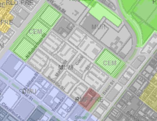
1 CITY PLANNING COMMISSION CITY OF NEW ORLEANS LATOYA CANTRELL MAYOR ROBERT D. RIVERS EXECUTIVE DIRECTOR LESLIE T. ALLEY DEPUTY DIRECTOR Subdivision Docket 098/18 City Planning Commission Staff Report Executive Summary Applicant: Housing Authority of New Orleans Request: Resubdivision of existing lots: Undesignated Parcel between squares 186 & 159; Undesignated Parcel between squares 159 & 156; Undesignated Parcel between Squares 156 & 129; Undesignated Parcel C between squares 185 & 160; Undesignated Parcel between squares 160 & 155; Undesignated Parcel B between squares 155 & 130; and Undesiqnated Parcel between the eastern side of Crozat Street and N. Robertson Street into Proposed streets: Portions of N. Villere Street, Marais Street and Treme Street between Iberville & Bienville Streets; Portions of N. Villere Street, Marais Street and Treme Street between Bienville & Conti Streets; Portion of Bienville Street between the eastern side of Crozat Street and N. Robertson Street. Location: The undesignated parcels are located in the Second Municipal District, bounded by Iberville St., N. Robertson St., Conti St., and Basin Street. (PD 4). Summary of Proposal: Subdivision Docket 098/18 is a major subdivision application involving the dedication of several undesignated parcels to the City for use as streets within the Iberville neighborhood. The resubdivision and dedication would reinstate portions of the N. Villere, Marais, Treme, and Bienville Street rights-of-way, reconnecting a former street grid. The original street grid was disrupted in the 1940 s when the Iberville Housing Development was developed and the former streets were developed as courtyards and open spaces. After Hurricane Katrina in 2005, HANO and the City of New Orleans received funding from HUD for the redevelopment of Iberville. The redevelopment of Iberville occurred in a total of seven phases. As part of this redevelopment plan, the grid street pattern was reestablished through a series of resubdivision requests which corresponded with the phases of the redevelopments. Those subdivision dockets were Subdivsiion SD098/18 1
2 Dockets 082/13, 150/14, 117/15, and 137/16. The approval of these requests created the squares that make up the housing sites, and seven (7) undesignated parcels were created for the future rededication of streets. The rededication is the final procedural component of the Iberville redevelopment. The purpose of this subdivision request is to dedicate those undesignated parcels as street rights of way and the improvements back to the City of New Orleans. Those street dedications are: 1. Portions of N. Villere Street, between Iberville & Bienville Streets 2. Marais Street between Iberville & Bienville Streets 3. Treme Street between Iberville & Bienville Streets 4. Portions of N. Villere Street between Bienville & Conti Streets 5. Marais Street between Bienville & Conti Streets 6. Treme Street between Bienville & Conti Streets 7. Portion of Bienville Street between the eastern side of Crozat Street and N. Robertson Street. The dedication is necessary to reinstate the former street grid, undoing the atypical superblock condition that characterized the site for decades, and completing the process of reconnecting the site to the surrounding neighborhood. Per the requirements of the Subdivision Regulations, if such a dedication is tentatively approved by the Commission, a dedication plan and a draft of an ordinance authorizing dedication shall be submitted to the Division of Real Estate and Records and the Commission for review and approval. If the submitted plan and ordinance are in accordance with the approved plans and specifications, the draft of the Ordinance shall be submitted to the City Council for consideration and adoption. Master Plan: The proposal is consistent with the Master Plan. Recommendation: The staff recommends Tentative Approval of Subdivision Docket 098/18 with final approval subject to four (4) provisos. Reasons for Recommendation: 1. The proposal is consistent with the Master Plan. 2. The proposal is consistent with the requirements of the Subdivision Regulations, in particular Article 3, Section Policy D: Changes In Street Pattern (Major Subdivisions). 3. The request finalizes the process of redeveloping the Iberville neighborhood as a dense mixed-use neighborhood by reinstating the street network, and undoing the superblock configuration. SD098/18 2
3 City Planning Commission Meeting September 25, 2018 CONSIDERATION SUBDIVISION DOCKET 098/18 Applicant: Housing Authority of New Orleans Prepared By: Nicolette Jones & Tim Jackson Date: September 18, 2018 Deadline: October 16, 2018 GENERAL INFORMATION Proposal: Resubdivision of existing lots: Undesignated Parcel between squares 186 & 159; Undesignated Parcel between squares 159 & 156; Undesignated Parcel between Squares 156 & 129; Undesignated Parcel C between squares 185 & 160; Undesignated Parcel between squares 160 & 155; Undesignated Parcel B between squares 155 & 130; and Undesignated Parcel between the eastern side of Crozat Street and N. Robertson Street into Proposed streets: Portions of N. Villere Street, Marais Street and Treme Street between Iberville & Bienville Streets; Portions of N. Villere Street, Marais Street and Treme Street between Bienville & Conti Streets; Portion of Bienville Street between the eastern side of Crozat Street and N. Robertson Street. Location: Zoning: Current Land Use: Proposed Land Use: The undesignated parcels are located in the Second Municipal District, bounded by Iberville St., N. Robertson St., Conti St., and Basin Street. (PD 4). MU-1 Medium Intensity Mixed-Use District The properties in question are not being used for any specific land use, but are currently being used as streets within the Iberville Development. The Iberville development contains several recently constructed multi-family buildings ranging in size from two to four stories. Some of the structures fronting Basin Street contain ground-floor commercial uses. The use of the properties will not change; they will remain being used as streets for access within the Iberville neighborhood, and will become dedicated streets through this major subdivision process. Required: This proposal is reviewed under Article 3, Section Policy D: Changes In Street Pattern (Major Subdivisions) of the Subdivision Regulations. Policy D explicitly requires both Commission review and a public hearing prior to a decision by the Commission. Major Subdivisions SD098/18 3

4 involving changes in street patterns must be reviewed by the Commission and are not eligible for Administrative Approval. Figure 1: Zoning Map Figure 2: Survey of Subject Property SD098/18 4
5 Background The Iberville neighborhood was initially developed during the mid to late 19 th century; it was an extension of the French Quarter, commonly known as the back of town. Historic Sanborn maps show that the area was developed with a dense mixture of residential, commercial, and industrial uses, built on compact lots, similar in form to the city s historic neighborhoods. In the early 19 th century, the area was also the site of what was known as Storyville, a restricted district that allowed legal prostitution. The district was abolished in Subsequent to the shutdown of the Storyville district, continued disinvestment in the area, as well as public health concerns regarding the area s abundance of substandard housing, led to the area s establishment as one of first proposed sites for federally funded public housing in the 1940s. Almost all of the previously existing 19 th century structures in the area were demolished in 1940 to clear land for the Iberville Public Housing Development. At the time the public housing development was built, there were not the same subdivision regulations as there are today; thus, the new housing development was built over the lot pattern of original development in the neighborhood and never resubdivided. The Iberville Public Housing Development originally consisted of 75 two and three-story brick townhouses and one administration building. The City sold most of the public rights-of-way within the site, in order for them to be converted to open pedestrian courtyards. The sale enabled the creation of the Iberville superblock. The historic housing development was evocative of the urban planning principles of the time, influenced by the garden city, urban renewal, and slum clearance movements. Post - Katrina Although there was little significant damage, the Iberville Public Housing Development was closed in 2005 following Hurricane Katrina. In 2011, the City and HANO were awarded a grant by United States Department of Housing and Urban Development (HUD) to transform the Iberville development and revitalize the historic Tremé district. The grant was part of HUD s Choice Neighborhoods Initiative, designed to transform distressed neighborhoods and public and assisted projects into viable and sustainable mixed-income neighborhoods by linking housing improvements with appropriate services, schools, public assets, transportation, and access to jobs. As the redevelopment is federally funded, the property was subject to an environmental review process per Section 106 of the Historic Preservation Act to mitigate any impact that the redevelopment may have on off-site historical elements. The development was also subject to the Advisory Council of Historic Preservation regulations. Part of the redevelopment plan included the breaking up of the Iberville superblock through the reinstatement of the City s historic rights-of-way and street grid pattern previously revoked in the 1940 s; the objective being to provide more connectivity to and within the area. The redevelopment plan also called for the demolition of 60 of the previous historic brick masonry structures; however, 16 have been preserved, including the administration building on Tremé Street. The 15 historic residential buildings are SD098/18 5

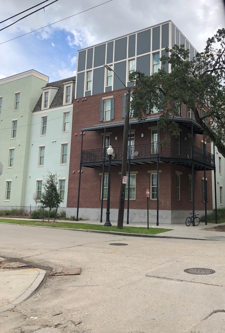
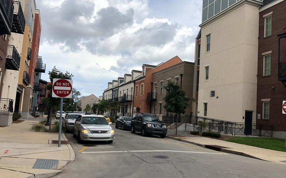
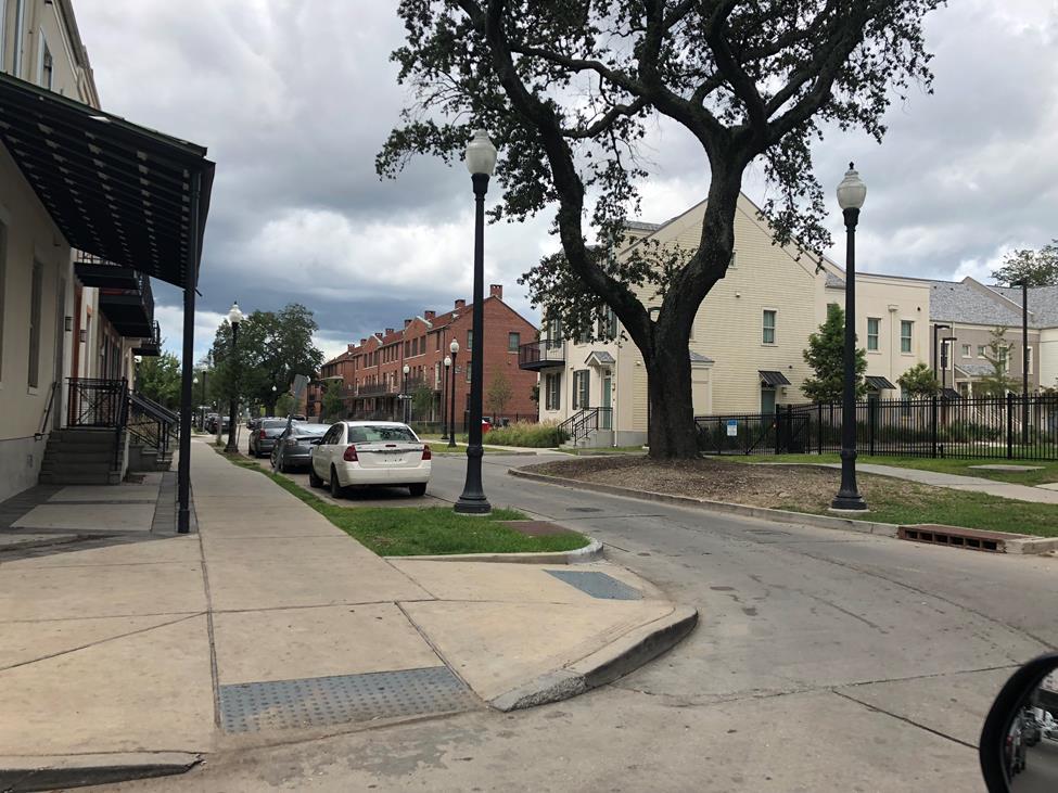
6 concentrated along the axes of Bienville and Marais Streets. The rest of the area was developed with a mixture of new multi-family structures and townhouses which complement the styles of the 1940s historic structures. The new development was constructed in seven phases, which the last and final phase almost complete. Upon completion of the entire development, the area will comprise eight hundred (880) new residential units. During each phase, the developer resubdivided the applicable squares (which still maintained the original lot pattern of the late 19 th century) with minor subdivision applications to comply with current building codes and the subdivision regulations. The developer resubdivided the property with a series of minor subdivision applications as opposed to one major subdivision application. This was done to align with financing procedures. However, prior to the permitting of phase one, the developers submitted engineering plans to the Departments of Public Works, the Sewerage and Water Board, and the Department of Parks and Parkways, for approval of the improvements to the proposed reinstated streets. These plans have been approved and the streets constructed. Figures 3 & 4: Photographs of Existing Street Improvements and Housing Development Corner of Iberville and N. Villere Streets Corner of Treme and Iberville Streets SD098/18 6
 undesignated parcels that have been improved and function as streets. These undesignated parcels, along with eight (8) squares (nos.")
7 Figure 5: Photograph of Existing Street Improvements and Housing Development Bienville Street at Treme Street Looking toward Marais Street Existing Conditions: The subject properties consist of seven (7) undesignated parcels that have been improved and function as streets. These undesignated parcels, along with eight (8) squares (nos. 129, 130, 155, 156, 159, 160, 185, and 186) containing multi-family housing developments, were created through a series of subdivision requests. The proposed street designations are currently the following parcels: 1. Undesignated Parcel between squares 186 & 159; 2. Undesignated Parcel between squares 159 & 156; 3. Undesignated Parcel between Squares 156 & 129; 4. Undesignated Parcel C between squares 185 & 160; 5. Undesignated Parcel between squares 160 & 155; 6. Undesignated Parcel B between squares 155 & 130; and 7. Undesignated Parcel between the eastern side of Crozat Street and N. Robertson Street These squares and the undesignated parcels were created through several minor subdivision requests which coincided the different redevelopment phases of the Iberville project. The subdivision dockets were SD082-13, SD150-14, SD117-15, and SD SD098/18 7
8 Proposed Conditions: The configuration of the squares and existing streets created in the previous subdivision approvals mentioned previously will not change; however, the undesignated parcels will be dedicated as public streets. The undesignated parcels will become the following proposed streets: 1. N. Villere Street, between Iberville & Bienville Streets 2. Marais Street between Iberville & Bienville Streets 3. Treme Street between Iberville & Bienville Streets; 4. N. Villere Street between Bienville & Conti Streets 5. Marais Street between Bienville & Conti Streets 6. Treme Street between Bienville & Conti Streets; 7. Bienville Street between the eastern side of Crozat Street and N. Robertson Street. Figure 6: Undesignated Parcels to be Dedicated Streets SD098/18 8
9 ANALYSIS Surrounding Development The petitioned site is located in an MU-1 Medium Intensity Mixed-Use District in the Iberville neighborhood. The neighborhood is centrally located; it borders the French Quarter, the Tremé Local Historic District, as well as the Central Business District. As such, the surrounding area encompasses a wide range of diverse land uses including several institutional, commercial, residential, and some light industrial uses. The area is also situated between several key transportation corridors including Canal Street, North Claiborne Avenue, and the Lafitte Greenway. The petitioned site is well served by public transit. The Iberville neighborhood is bounded by North Robertson, St. Louis, Basin, and Iberville Streets. Both the St. Louis Cemetery No. 1 and the St. Louis Cemetery No. 2 border the area to its northwestern and southeastern sides. The neighborhood is renowned for being the site of one of the first pre-wwii public housing developments in the city, developed in 1941 following the Wagner-Steagall Housing Act of Compliance with the Comprehensive Zoning Ordinance and the Subdivision Regulations: Subdivision Regulations The proposal complies with the applicable provisions of the Subdivision Regulations. This proposal is reviewed in accordance with Article 3, Policy D: Changes In Street Pattern (Major Subdivisions) of the Subdivision Regulations. This policy explicitly requires both Commission review and a public hearing prior to a decision by the Commission. Major Subdivisions involving changes in street patterns must be reviewed by the Commission and are not eligible for Administrative Approval. This subdivision request is not creating new lots, nor reconfiguring existing lot dimensions. This request only involves converting undesignated parcels, currently being used as streets, into dedicated public streets. As mentioned previously the undesignated parcels were created (in a sense as place-holders for future streets) through several minor subdivision requests involving the different redevelopment phases of the Iberville redevelopment project. This proposal complies with the applicable provisions of the Subdivision Regulations, and the engineering plans for the streets have already been approved by the applicable agencies. The plans were found to meet the General Standards of Design of the Subdivision Regulations as set out Section 5.2 in terms of its relation to the adjoining street system, minimum street width, minimum sidewalk width, grading and surfacing requirements, on-street parking provisions, and required landscaping. The engineering plans were approved in March 2014, and a copy of the plans is within the attachments of this report. SD098/18 9
10 Per the requirements of the Subdivision Regulations, if such a dedication is tentatively approved by the Commission, a dedication plan and a draft of an ordinance authorizing dedication shall be submitted to the Division of Real Estate and Records and the Commission for review and approval. If the submitted plan and ordinance are in accordance with the approved plans and specifications, the draft of the Ordinance shall be submitted to the City Council for consideration and adoption. Comprehensive Zoning Ordinance The subject property is within an MU-1 Medium Intensity Mixed-Use District. The squares shown on the submitted survey were created in previous subdivision requests (SD082-13, SD150-14, and SD117-15) and all of squares are compliant with the Comprehensive Zoning Ordinance s minimum lot size requirement for a multi-family use. The undesignated parcels were intended to create the future street rights of way to be dedicated to the City of New Orleans. Utilities & Regulatory Agencies: The City Planning Commission, when reviewing a proposed subdivision, requests written responses from the Department of Property Management Division of Real Estate and Records, Department of Public Works, Department of Safety and Permits, Sewerage and Water Board, Entergy, and the Historic District Landmarks Commission (where applicable) regarding the compliance of the proposed subdivision with the building codes, zoning ordinance, and other regulatory documents governing development in the city. As of the writing of this report, the Department of Safety and Permits, the Department of Property Management, Division of Real Estate and Records, and the Department of Public Works have reviewed and approved this request. The representative of the Sewerage and Water Board indicated that sewer and water facilities are available but not shown on the re-subdivision plan. It also noted that sewer and water house connections are not shown and, therefore, a note should be made on the survey stating that sewer and water house connections are the responsibility of the property owner. The Department of Public Works Engineering Division noted that Phases I and II of the street construction has received final acceptance from DPW. Phase III has yet to receive final acceptance, and will need to be inspected prior to final approval of the subdivision. Planning Advisory Committee In addition to written comments, representatives of City departments were asked to comment on the proposal at the Planning Advisory Committee meeting of September 5, The Department of Parks and Parkways noted that several tree plantings in the streets have failed and may need to be replaced. The Committee passed a motion of no objection subject to further review by the City Planning Commission and the Parks and Parkways Commission staffs. SD098/18 10
11 PLAN FOR THE 21 ST CENTURY Are the proposed actions supported by or in conflict with the policies and strategies of the Plan for the 21 st Century: New Orleans 2030? The Home Rule Charter of the City of New Orleans requires all land use actions (including subdivision) to be consistent with the Master Plan. A land use action is consistent with the Master Plan if it furthers, or at least does not interfere with, the goals, policies, and guidelines in the Land Use Element of the Master Plan and is compatible with the uses, densities, and intensities of the designation of its site on the future land use map. The Master Plan s future land use map ( Chapter 13: Land Use Plan of the Master Plan) designates this site for Mixed-Use Medium Density future land use. The goal, range of uses and development character for the Mixed-Use Medium Density designation is copied below: MIXED-USE MEDIUM DENSITY Goal: Create medium-density neighborhood centers to enhance walkability and serve as focal points within neighborhoods. Proximity to transit encouraged. Range of Uses: Medium-density single-family, two-family and multifamily residential and commercial uses. Limited light industrial uses (craft and value added industry and passive warehousing and storage) may be allowed in some areas. Development Character: Height/mass, and density of new development varied to ensure proper transitions to surrounding lower density residential neighborhoods. Many structures will feature ground floor retail with residences on upper floors. The proposed resubdivision of the site for residential development is consistent with the Mixed-Use Medium Density designation, as that designation is intended for single- and two-family residential development, as well as multiple-family residential, commercial, and limited light industrial use. The approval of the rededication of former street rightsof-way support the goals to enhance walkability and connectivity within this community. SUMMARY Subdivision Docket is a major subdivision application involving the dedication of several undesignated parcels to the City for use as streets within the Iberville neighborhood. The resubdivision and dedication would reinstate portions of the N. Villere, Marais, Treme, and Bienville Street rights-of-way, reconnecting a former street grid. The original street grid was disrupted in the 1940 s when the Iberville Housing Development was developed and the former streets were developed as courtyards and SD098/18 11
12 open spaces. After Hurricane Katrina in 2005, HANO and the City of New Orleans received finding from HUD for the redevelopment of Iberville. The redevelopment of Iberville occurred in a total of seven phases. As part of this redevelopment plan, the grid street pattern was re-established through a series of resubdivision requests which corresponded with the phases of the redevelopments. Those subdivision dockets were SD082-13, SD150-14, SD117-15, and SD The approval of these requests created the squares that make up the housing sites, and seven (7) undesignated parcels were created for the future rededication of streets. The rededication is the final procedural component of the Iberville redevelopment. The purpose of this subdivision request is to dedicate those undesignated parcels as street rights of way and the improvements back to the City of New Orleans. Those street dedications are: 1. N. Villere Street, between Iberville & Bienville Streets 2. Marais Street between Iberville & Bienville Streets 3. Treme Street between Iberville & Bienville Streets 4. N. Villere Street between Bienville & Conti Streets 5. Marais Street between Bienville & Conti Streets 6. Treme Street between Bienville & Conti Streets 7. Bienville Street between the eastern side of Crozat Street and N. Robertson Street. The dedication is necessary to reinstate the former street grid, undoing the atypical superblock condition that characterized the site for decades, and completing the process of reconnecting the site to the surrounding neighborhood. Per the requirements of the Subdivision Regulations, if such a dedication is tentatively approved by the Commission, a dedication plan and a draft of an ordinance authorizing dedication shall be submitted to the Division of Real Estate and Records and the Commission for review and approval. If the submitted plan and ordinance are in accordance with the approved plans and specifications, the draft of the Ordinance shall be submitted to the City Council for consideration and adoption. PRELIMINARY STAFF RECOMMENDATION The staff recommends that the City Planning Commission grant tentative approval of Subdivision Docket with final approval subject to four (4) provisos: Provisos 1. The applicant shall comply with any requirements deemed necessary by Entergy, the Sewerage and Water Board, the Departments of Public Works, the Department of Property Management, Division of Real Estate and Records, Department of Parks and Parkways, and the Department of Safety and Permits. SD098/18 12
13 2. The applicant shall submit all documentation for Final Approval as required per Section of the Subdivision Regulations. 3. The applicant shall comply with all other Subdivision Regulations, which includes the submittal of mortgage certificates, a consent letter from the mortgage company (if applicable) and tax certificates for the petitioned site. 4. The applicant shall submit a reproducible copy and two (2) prints and a digital copy of the final resubdivision survey in.pdf compatible file format. REASONS FOR RECOMMENDATION 1. The proposal is consistent with the Master Plan. 2. The proposal is consistent with the requirements of the Subdivision Regulations, in particular Article 3, Section Policy D: Changes In Street Pattern (Major Subdivisions). 3. The request finalizes the process of redeveloping the Iberville neighborhood as a dense mixed-use neighborhood by reinstating the street network, and undoing the superblock configuration. SD098/18 13
14 Zoning
15 FLUM
16 Survey

17 Streets to be Dedicated

18 Aerial Photo (2016)


19 Photos Existing Streets and Adjacent Housing Developments
20
21
22
23
24
25
26 W N S E C O N T I S T R E E T SQ 155 SQ 130 MARAIS STREET TREME STREET SQ 160 N. VILLERE STREET SQ 190 SQ 185 N. R O B E R T S O N S T R E E T TREME STREET CROZAT STREET SQ 189 SQ 186 SQ 159 SQ 156 SQ 129 SQ 124 N. VILLERE STREET MARAIS STREET B A S I N S T R E E T SECOND DISTRICT CITY OF NEW ORLEANS B I E N V I L L E S T R E E T I B E R V I L L E S T R E E T N W E S
CITY PLANNING COMMISSION CITY OF NEW ORLEANS EXECUTIVE DIRECTOR. City Planning Commission Staff Report. Executive Summary
 CITY PLANNING COMMISSION CITY OF NEW ORLEANS MITCHELL J. LANDRIEU MAYOR ROBERT D. RIVERS EXECUTIVE DIRECTOR Subdivision Docket 105-16 City Planning Commission Staff Report Executive Summary LESLIE T. ALLEY
CITY PLANNING COMMISSION CITY OF NEW ORLEANS EXECUTIVE DIRECTOR. City Planning Commission Staff Report. Executive Summary
 CITY PLANNING COMMISSION CITY OF NEW ORLEANS MITCHELL J. LANDRIEU MAYOR ROBERT D. RIVERS EXECUTIVE DIRECTOR LESLIE T. ALLEY DEPUTY DIRECTOR City Planning Commission Staff Report Zoning Docket: 050/16 Executive
CITY PLANNING COMMISSION CITY OF NEW ORLEANS EXECUTIVE DIRECTOR. City Planning Commission Staff Report. Executive Summary
 CITY PLANNING COMMISSION CITY OF NEW ORLEANS MITCHELL J. LANDRIEU MAYOR ROBERT D. RIVERS EXECUTIVE DIRECTOR LESLIE T. ALLEY DEPUTY DIRECTOR City Planning Commission Staff Report Zoning Docket 059/16 Executive
CITY PLANNING COMMISSION CITY OF NEW ORLEANS EXECUTIVE DIRECTOR. City Planning Commission Staff Report. Executive Summary
 CITY PLANNING COMMISSION CITY OF NEW ORLEANS MITCHELL J. LANDRIEU MAYOR ROBERT D. RIVERS EXECUTIVE DIRECTOR LESLIE T. ALLEY DEPUTY DIRECTOR City Planning Commission Staff Report Zoning Docket 096/16 Executive
CITY PLANNING COMMISSION CITY OF NEW ORLEANS EXECUTIVE DIRECTOR. City Planning Commission Staff Report. Executive Summary
 CITY PLANNING COMMISSION CITY OF NEW ORLEANS MITCHELL J. LANDRIEU MAYOR ROBERT D. RIVERS EXECUTIVE DIRECTOR LESLIE T. ALLEY DEPUTY DIRECTOR City Planning Commission Staff Report Zoning Docket: 032/18 Executive
CITY PLANNING COMMISSION CITY OF NEW ORLEANS EXECUTIVE DIRECTOR. City Planning Commission Staff Report. Executive Summary
 CITY PLANNING COMMISSION CITY OF NEW ORLEANS MITCHELL J. LANDRIEU MAYOR ROBERT D. RIVERS EXECUTIVE DIRECTOR LESLIE T. ALLEY City Planning Commission Staff Report Executive Summary Zoning Docket 053/16
CITY PLANNING COMMISSION CITY OF NEW ORLEANS EXECUTIVE DIRECTOR. City Planning Commission Staff Report. Executive Summary
 CITY PLANNING COMMISSION CITY OF NEW ORLEANS MITCHELL J. LANDRIEU MAYOR ROBERT D. RIVERS EXECUTIVE DIRECTOR LESLIE T. ALLEY DEPUTY DIRECTOR City Planning Commission Staff Report Executive Summary Zoning
ZD Page 1 of 16 CITY PLANNING COMMISSION CITY OF NEW ORLEANS EXECUTIVE DIRECTOR. City Planning Commission Staff Report.
 ZD049-16 Page 1 of 16 CITY PLANNING COMMISSION CITY OF NEW ORLEANS MITCHELL J. LANDRIEU MAYOR ROBERT D. RIVERS EXECUTIVE DIRECTOR LESLIE T. ALLEY DEPUTY DIRECTOR City Planning Commission Staff Report Executive
CITY PLANNING COMMISSION
 CITY PLANNING COMMISSION TO: HONORABLE CITY COUNCIL FROM: CITY PLANNING COMMISSION DATE: AUGUST 3, 2017 SUBJECT: REPORT AND RECOMMENDATION OF THE CITY PLANNING COMMISSION Ladies and Gentlemen: Attached
CITY PLANNING COMMISSION CITY OF NEW ORLEANS EXECUTIVE DIRECTOR. City Planning Commission Staff Report. Executive Summary
 CITY PLANNING COMMISSION CITY OF NEW ORLEANS MITCHELL J. LANDRIEU MAYOR ROBERT D. RIVERS EXECUTIVE DIRECTOR LESLIE T. ALLEY DEPUTY DIRECTOR City Planning Commission Staff Report Zoning Docket 092/16 Executive
CITY PLANNING COMMISSION CITY OF NEW ORLEANS EXECUTIVE DIRECTOR. City Planning Commission Staff Report. Executive Summary
 CITY PLANNING COMMISSION CITY OF NEW ORLEANS MITCHELL J. LANDRIEU MAYOR ROBERT D. RIVERS EXECUTIVE DIRECTOR LESLIE T. ALLEY DEPUTY DIRECTOR City Planning Commission Staff Report Executive Summary Zoning
CITY PLANNING COMMISSION CITY OF NEW ORLEANS MITCHELL J. LANDRIEU ROBERT D. RIVERS EXECUTIVE DIRECTOR. City Planning Commission Staff Report
 CITY PLANNING COMMISSION CITY OF NEW ORLEANS MITCHELL J. LANDRIEU ROBERT D. RIVERS MAYOR EXECUTIVE DIRECTOR City Planning Commission Staff Report LESLIE T. ALLEY DEPUTY DIRECTOR Zoning Docket: 108/16 Executive
AFFORDABLE TREMÉ. Housing density & TremÉ
 AFFORDABLE TREMÉ COMPILED BY THE SMALL CENTER FOR COLLABORATIVE DESIGN AND THE GREATER TREMÉ CONSORTIUM Housing density & TremÉ Tremé has always been dense. Row houses, shotguns, and cottages are all historic
DRAFT Plan Incentives. Part A: Basic Discount
 DRAFT 2030 Plan Incentives July 26, 2006 Part A: Basic Discount In order for a development to be eligible for any 2030 Land Resource Management Plan Discounts it must be located in the Urban Corridor and
WESTMINSTER PARK SUBDIVISION
 WESTMINSTER PARK SUBDIVISION Engineering Comments: FINAL PLAT COMMENTS (should be addressed prior to submitting the FINAL PLAT for review and/or signature by the City Engineer): A. Provide all of the required
2.0 LAND USE FRAMEWORK
 Land Use Framework 2.0 LAND USE FRAMEWORK FOLSOM BOULEVARD 2.1 LAND USE OVERVIEW The proposed land uses for Easton Place offer local and regional employment, shopping, and entertainment, highlighting the
CITY PLANNING COMMISSION
 CITY PLANNING COMMISSION TO: HONORABLE CITY COUNCIL FROM: CITY PLANNING COMMISSION DATE: OCTOBER 30, 2017 SUBJECT: REPORT AND RECOMMENDATION OF THE CITY PLANNING COMMISSION Ladies and Gentlemen: Attached
CITY PLANNING COMMISSION CITY OF NEW ORLEANS EXECUTIVE DIRECTOR. City Planning Commission Staff Report Executive Summary
 CITY PLANNING COMMISSION CITY OF NEW ORLEANS MITCHELL J. LANDRIEU MAYOR ROBERT D. RIVERS EXECUTIVE DIRECTOR LESLIE T. ALLEY DEPUTY DIRECTOR City Planning Commission Staff Report Executive Summary Zoning
PARRAMORE OAKS FRAMEWORK PLANNED DEVELOPMENT
 PARRAMORE OAKS FRAMEWORK PLANNED DEVELOPMENT Presented by Mark Cechman, AICP Paul S. Lewis, FAICP Review Process Pre- Application meeting August 11, 2016 Attended by representatives of: City Planning Transportation
3.0 Project Description
 3.0 Project Description City of Long Beach Shoreline Gateway Project Environmental Impact Report 3.0 PROJECT DESCRIPTION 3.1 PROJECT LOCATION AND SETTING PROJECT LOCATION The proposed Shoreline Gateway
Bridgeland-Riverside Area Redevelopment Plan (ARP)
") Bridgeland-Riverside Area Redevelopment Plan (ARP) The current Bridgeland-Riverside Area Redevelopment Plan (ARP) was approved in 1980. Since then, a lot of changes have taken place in the city and the
Bridgeland-Riverside Area Redevelopment Plan (ARP) The current Bridgeland-Riverside Area Redevelopment Plan (ARP) was approved in 1980. Since then, a lot of changes have taken place in the city and the
PLANNED UNIT DEVELOPMENT & SUBDIVISION STAFF REPORT Date: April 18, 2019
 PLANNED UNIT DEVELOPMENT & SUBDIVISION STAFF REPORT Date: April 18, 2019 DEVELOPMENT NAME SUBDIVISION NAME Springhill Village Subdivision Springhill Village Subdivision LOCATION 4350, 4354, 4356, 4358,
Appendix A: Guide to Zoning Categories Prince George's County, Maryland
 Appendix A: Guide to Zoning Categories Prince George's County, Maryland RESIDENTIAL ZONES 1 Updated November 2010 R-O-S: Reserved Open Space - Provides for permanent maintenance of certain areas of land
WESTMINSTER PARK PLACE SUBDIVISION
 WESTMINSTER PARK PLACE SUBDIVISION Engineering Comments: FINAL PLAT COMMENTS (should be addressed prior to submitting the FINAL PLAT for review and/or signature by the City Engineer): A. Provide all of
Village of Port Jefferson Urban Renewal Plan
 Urban Renewal Plan Village of Port Jefferson Urban Renewal Plan Port Jefferson, New York PREPARED FOR Village of Port Jefferson Village Board 121 West Broadway Port Jefferson, NY 11777 631.473.4724 PREPARED
5. Housing. Other Relevant Policies & Bylaws. Several City-wide policies guide our priorities for housing diversity at the neighbourhood level: Goals
 5. Housing Other Relevant Policies & Bylaws Several City-wide policies guide our priorities for housing diversity at the neighbourhood level: Goals 1. Encourage more housing diversity while maintaining
DEPARTMENT OF PLANNING JEFFERSON PARISH, LOUISIANA
 DEPARTMENT OF PLANNING JEFFERSON PARISH, LOUISIANA SUBDIVISION REPORT DOCKET NO: ES-89-15-PF SUMMARY NO: COUNCIL DISTRICT 2 Paul D. Johnston COUNCIL AT LARGE: A Chris Roberts B Elton M. Lagasse ADVERTISING
HOUSING ELEMENT GOALS, OBJECTIVES, AND POLICIES
 HOUSING ELEMENT GOALS, OBJECTIVES, AND POLICIES GOAL 1: To promote the preservation and development of high-quality, balanced, and diverse housing options for persons of all income levels throughout the
Board of Zoning Adjustments Staff Report Monthly Meeting Monday, June 13, 2016
 Board of Zoning Adjustments Staff Report Monthly Meeting Monday, June 13, 2016 Docket Number: 045-16 Prepared by: Nicolette P. Jones Applicant or Agent: Henry Hanisee, Aaron Motwani, Joseph J. Paciera
H-POLICY 1: Preserve and improve existing neighborhoods. Ensure that Prince William County achieves new neighborhoods with a high quality of life.
 HOUSING Intent The intent of the Housing Plan is to provide a framework for providing for the housing needs of all residents of Prince William County. These needs are expressed in terms of quality, affordability,
Development of a temporary grass multisport pitch and associated works (in addition to the previously approved park - Phase A).
.") To the Lord Mayor and Report No. 163/2018 Members of Dublin City Council Report of the Chief Executive (a) Planning and Development Act 2000 (as amended) & Planning and Development Regulations 2001 (as
To the Lord Mayor and Report No. 163/2018 Members of Dublin City Council Report of the Chief Executive (a) Planning and Development Act 2000 (as amended) & Planning and Development Regulations 2001 (as
CITY PLANNING COMMISSION CITY OF NEW ORLEANS EXECUTIVE DIRECTOR. City Planning Commission Staff Report. Executive Summary
 CITY PLANNING COMMISSION CITY OF NEW ORLEANS MITCHELL J. LANDRIEU MAYOR ROBERT D. RIVERS EXECUTIVE DIRECTOR LESLIE T. ALLEY DEPUTY DIRECTOR City Planning Commission Staff Report Zoning Docket 095/16 Executive
Truax Park Apartments
 Truax Park Apartments Master Planning and Site Development Study Prepared by The Community Development Authority of the City of Madison In association with SMITH & SMITH ASSOCIATES, Inc CONSTRUCTION COST
LAND USE ASSUMPTIONS REPORT POTENTIAL FUTURE DEVELOPMENT WEST WHITELAND TOWNSHIP, CHESTER COUNTY, PA
 LAND USE ASSUMPTIONS REPORT POTENTIAL FUTURE DEVELOPMENT WEST WHITELAND TOWNSHIP, CHESTER COUNTY, PA Adopted June 17, 2015 by Township Resolution No. 2015-30 Prepared by Theurkauf Design & Planning, LLC
ARTICLE 887. PD 887. Valley View - Galleria Area Special Purpose District
 ARTICLE 887. PD 887. Valley View - Galleria Area Special Purpose District SEC. 51P-887.101. LEGISLATIVE HISTORY. PD 887 was established by Ordinance No. 29032, passed by the Dallas City Council on June
Policy Issues City of Knoxville Zoning Code Update
 Policy Issues City of Knoxville Zoning Code Update ADU's (Accessory Dwelling Units) The draft zoning ordinance update permits ADU s as an accessory use in all single-family residential zoning districts.
Docket No. WS PF Orleans Village Section 1 Subdivision
 Planning Department Teresa A. Wilkinson, AICP Director STAFF REPORT Major Subdivision Docket No. WS-116-18-PF Orleans Village Section 1 Subdivision PARISH COUNCIL A: Christopher L. Roberts B: Cynthia Lee-Sheng
ARTICLE 3: Zone Districts
 ARTICLE 3: Zone Districts... 3-1 17.3.1: General...3-1 17.3.1.1: Purpose and Intent... 3-1 17.3.2: Districts and Maps...3-1 17.3.2.1: Applicability... 3-1 17.3.2.2: Creation of Districts... 3-1 17.3.2.3:
DIVISION 1 PURPOSE OF DISTRICTS
 ARTICLE 2 ZONING DISTRICTS AND MAP DIVISION 1 PURPOSE OF DISTRICTS Section 2.101 Zoning Districts. For the purpose of this Ordinance, the City of Richmond is hereby divided into districts as follows: DISTRICT
THE REDEVELOPMENT PLAN
 PAGE 37 THE REDEVELOPMENT PLAN FUTURE LAND USE The Silver Terrace Redevelopment Area is currently designated as Redevelopment Area #4 on the City of Delray Beach Future Land Use Map (FLUM). This designation
CITY PLANNING COMMISSION
 CITY PLANNING COMMISSION TO: HONORABLE CITY COUNCIL FROM: CITY PLANNING COMMISSION DATE: JUNE 1, 2018 SUBJECT: REPORT AND RECOMMENDATION OF THE CITY PLANNING COMMISSION Ladies and Gentlemen: Attached hereto
DEPARTMENT OF PLANNING JEFFERSON PARISH, LOUISIANA
 DEPARTMENT OF PLANNING JEFFERSON PARISH, LOUISIANA SUBDIVISION REPORT DOCKET NO: ES-1-17-PF SUMMARY NO.: COUNCIL DISTRICT: 2 Paul D. Johnston COUNCIL AT LARGE: A: Christopher L. Roberts B: Cynthia Lee-Sheng
GENERAL PLAN UPDATE SPECIFIC AREAS OF THE CITY
 GENERAL PLAN UPDATE SPECIFIC AREAS OF THE CITY Background There are a total of 14 specific areas that are being reviewed as part of the update of the General Plan. Requests to review these areas came from
RESIDENTIAL DISTRICTS
 RESIDENTIAL DISTRICTS RESIDENTIAL DISTRICTS The residential district standards have been revised to reflect on-the-ground development conditions, while continuing to respect the use patterns established
Comprehensive Plan /24/01
 IV The is a central component of the Comprehensive Plan. It is an extension of the general goals and policies of the community, as well as a reflection of previous development decisions and the physical
Glades County Staff Report and Recommendation Unified Staff Report for Small Scale Plan Amendment and Rezoning
 Glades County Staff Report and Recommendation Unified Staff Report for Small Scale Plan Amendment and Rezoning CASE NUMBERS: COMP17-02 and RZ17-02 DATE of STAFF REPORT: May 1, 2017 CASE TYPE: Application
Bylaw No , being "Official Community Plan Bylaw, 2016" Schedule "A" DRAFT
 Bylaw No. 2600-2016, being "Official Community Plan Bylaw, 2016" Schedule "A" Urban Structure + Growth Plan Urban Structure Land use and growth management are among the most powerful policy tools at the
ATTACHMENT #1 SUMMARY CHART
 ATTACHMENT #1 SUMMARY CHART Item # Amendment To: Nature of Proposed Amendment PCM201801 PCM201802 PCM201803 PCM201804 LMA201802 LMA201803 LMA201804 PCT201801 PCT201802 PCT201803 FUTURE LAND USE MAP Parkway
Chapter 5: Testing the Vision. Where is residential growth most likely to occur in the District? Chapter 5: Testing the Vision
 Chapter 5: Testing the Vision The East Anchorage Vision, and the subsequent strategies and actions set forth by the Plan are not merely conceptual. They are based on critical analyses that considered how
Official Zoning Map Amendment Application #2017I Gaylord Street and York Street Rezoning from U-RH-2.5 to U-RX-3 and U-RX-5
 Community Planning and Development Planning Services 201 W. Colfax Ave., Dept. 205 Denver, CO 80202 p: 720.865.2915 f: 720.865.3052 www.denvergov.org/cpd TO: Denver Planning Board FROM: Elizabeth Weigle,
CITY OF NAPLES STAFF REPORT
 Meeting of 11/9/16 Subdivision/Replat Petition 16-SD3 CITY OF NAPLES STAFF REPORT To: Planning Advisory Board From: Planning Department Subject: Subdivison/Replat Petition 16-SD3 Petitioner: Matthew Grabinski,
TOTTENHAM SECONDARY PLAN
 TOTTENHAM SECONDARY PLAN AMENDMENT NO. 11 TO THE OFFICIAL PLAN OF THE TOWN OF NEW TECUMSETH The following text and schedules to the Official Plan of the Town of New Tecumseth constitute Amendment No. 11
Missing Middle Housing in Practice
 Missing Middle Housing in Practice Daniel Parolek Principal, Opticos Design, Inc. dan@opticosdesign.com New Partners for Smart Growth Kansas City, MO 2013 1 Bungalow Courts Missing MIddle Housing 2012
DRAFT Housing Technical Bulletin
 DRAFT Housing Technical Bulletin This guidance is intended to clarify how the Housing Goal and Objectives of the Regional Policy Plan (RPP) are to be applied and interpreted in Cape Cod Commission Development
Goal 1 - Retain and enhance Cherry Creek North s unique physical character.
 Introduction This document summarizes the proposed new zoning for the area of roughly bordered by University Boulevard, Steele Street, 3rd Avenue, and 1st Avenue. It provides a high-level review of the
Place Type Descriptions Vision 2037 Comprehensive Plan
 Place Type Descriptions Vision 2037 Comprehensive Plan The Vision 2037 Comprehensive Plan establishes a range of place types for Oxford, ranging from low intensity (limited development) Rural and Natural
Comprehensive Plan Amendment #PLN , Reserve at Cannon Branch (Coles Magisterial District)
") COUNTY OF PRINCE WILLIAM 5 County Complex Court, Prince William, Virginia 22192-9201 PLANNING (703) 792-7615 FAX (703) 792-4758 OFFICE Internet www.pwcgov.org Christopher M. Price, AICP Director of Planning
COUNTY OF PRINCE WILLIAM 5 County Complex Court, Prince William, Virginia 22192-9201 PLANNING (703) 792-7615 FAX (703) 792-4758 OFFICE Internet www.pwcgov.org Christopher M. Price, AICP Director of Planning
DISCUSSION DRAFT 1 INTRODUCTORY PROVISIONS
 1 INTRODUCTORY PROVISIONS 1.1 GENERAL...3 Title 3 Authority 3 Applicability 3 Purpose 3 Regulatory Scope 4 Compliance 4 Fines and Penalties 4 Conflicting Provisions 5 Meaning & Intent 5 Text & Graphics
CITY OF NAPLES STAFF REPORT
 Meeting of 05/13/15 Conditional Use Petition 15-CU3 CITY OF NAPLES STAFF REPORT To: Planning Advisory Board From: Planning Department Subject: Conditional Use Petition 15-CU3 Petitioner: Hazelden Betty
CITY OF KAMLOOPS BYLAW NO A BYLAW TO AMEND THE ZONING BYLAW OF THE CITY OF KAMLOOPS
 67 68 CITY OF KAMLOOPS BYLAW NO. 5-1-2796 A BYLAW TO AMEND THE ZONING BYLAW OF THE CITY OF KAMLOOPS The Municipal Council of the City of Kamloops, in open meeting assembled, enacts as follows: 1. This
7 August 14, 2013 Public Hearing
 7 August 14, 2013 Public Hearing APPLICANT & OWNER: STAFF PLANNER: Stephen J. White REQUEST: Conditional Use Permit (motor vehicle sales) ADDRESS / DESCRIPTION: 4717 Hollis Road / 4740 Shore Drive GPIN:
TULSA PARK ESTATES SUBDIVISION, RESUBDIVISION OF LOT 6
 TULSA PARK ESTATES SUBDIVISION, RESUBDIVISION OF LOT 6 Engineering Comments: FINAL PLAT COMMENTS (should be addressed prior to submitting the FINAL PLAT for review and/or signature by the City Engineer):
COMMUNICATION URBAN DESIGN REVIEW BOARD CITY OF DES MOINES, IOWA NOVEMBER 1, 2016, 2016 MEETING
 COMMUNICATION URBAN DESIGN REVIEW BOARD CITY OF DES MOINES, IOWA NOVEMBER 1, 2016, 2016 MEETING Subject: Recommendation Prepared by: PRELIMINARY DESIGN AND FINANCIAL REVIEW 401 SE 6 TH STREET- CONNOLLY
Land Use. Land Use Categories. Chart 5.1. Nepeuskun Existing Land Use Inventory. Overview
 Land Use State Comprehensive Planning Requirements for this Chapter A compilation of objectives, policies, goals, maps and programs to guide the future development and redevelopment of public and private
Community Development
 Land Use Petition RZ-16-002 Date of Staff Recommendation Preparation: April 15, 2016 (CEL) Date of Planning Commission Recommendation: May 3, 2016 PROJECT LOCATION: DISTRICT/SECTION/LANDLOT(S): ACREAGE
Board of Zoning Adjustments Staff Report Monthly Meeting Monday, April 11, 2016
 Board of Zoning Adjustments Staff Report Monthly Meeting Monday, April 11, 2016 Docket Number: 020-16 Prepared by: Brooke Perry Applicant or Agent: Donald Maginnis Architect, Inc., Eugene Hoskins, Joan
Staff Report and Recommendation Based on the criteria for review in the Denver Zoning Code, Staff recommends approval for Application #2017I
 TO: Denver Planning Board, Joel Noble, Chair FROM: Theresa Lucero, Senior City Planner DATE: RE: Official Zoning Map Amendment Application #2017I-00163 Staff Report and Recommendation Based on the criteria
Nassau County 2030 Comprehensive Plan. Housing Element (H) Goals, Objectives and Policies. Goal
 Goals, Objectives and Policies. Goal") (H) Goal Assist the private sector to provide and maintain an adequate inventory of decent, safe and sanitary housing in suitable neighborhoods at affordable costs to meet the need of the present and future
(H) Goal Assist the private sector to provide and maintain an adequate inventory of decent, safe and sanitary housing in suitable neighborhoods at affordable costs to meet the need of the present and future
MONROE WARD REZONING SUMMARY. October 2018
 MONROE WARD REZONING SUMMARY October 2018 WHY IS THE CITY REZONING MONROE WARD? In July of 2017 Richmond City Council adopted The Pulse Corridor Plan, a corridor-long planning document that outlines steps
Poverty Rates by Census Tracts
 The following document is a presentation that was delivered to the Housing Conservation District Advisory Group (HCDAG). The materials contained in this presentation (including several updates) were prepared
DAUPHIN CREEK ESTATES SUBDIVISION
 # 12 SUB-000076-2017 DAUPHIN CREEK ESTATES SUBDIVISION Engineering Comments: FINAL PLAT COMMENTS (should be addressed prior to submitting the FINAL PLAT for review and/or signature by the City Engineer):
Indicates Council-recommended changes Introduced by: Mr. Tackett Date of introduction: June 14, 2016 SUBSTITUTE NO. 1 TO ORDINANCE NO.
 Indicates Council-recommended changes Introduced by: Mr. Tackett Date of introduction: June 14, 2016 SUBSTITUTE NO. 1 TO ORDINANCE NO. 16-067 TO AMEND NEW CASTLE COUNTY CODE CHAPTER 40 (ALSO KNOWN AS THE
PLANNING COMMISSION MAY 3, 2018 PUBLIC HEARING
 PLANNING COMMISSION MAY 3, 2018 PUBLIC HEARING SUBJECT: REQUEST TO DEMOLISH TWO SINGLE-FAMILY DWELLINGS ON TWO ADJOINING LOTS AND CONSTRUCT TEN RESIDENTIAL CONDOMINIUM UNITS AT 947 GENESEE AVENUE AND 944
Staff Report for Council Public Meeting
 Agenda Item 3.3 Staff Report for Council Public Meeting Date of Meeting: September 27, 2017 Report Number: SRPRS.17.134 Department: Division: Subject: Planning and Regulatory Services Development Planning
LITTLE MOUNTAIN ADJACENT AREA REZONING POLICY
 LITTLE MOUNTAIN ADJACENT AREA REZONING POLICY JANUARY 2013 CONTENTS 1.0 INTENT & PRINCIPLES...1 2.0 APPLICATION...2 3.0 HOUSING TYPES, HEIGHT & DENSITY POLICIES...3 3.1 LOW TO MID-RISE APARTMENT POLICIES...4
Board of Zoning Adjustments Staff Report Monthly Meeting Monday, November 9, 2015
 Board of Zoning Adjustments Staff Report Monthly Meeting Monday, November 9, 2015 Docket Number: 170-15 Prepared by: Brooke Perry Applicant or Agent: Gwendolyn A. Bordenave Property Location: 301-303 S.
Staff Report for Town Council
 Staff Report for Town Council Meeting Date: June 22, 2017 16-REZ-24 Trimble Avenue Residential Rezoning Purpose: Consider action on proposed rezoning request Prepared by: Katie Drye, Planning Speaker:
Land Use, Transportation, and Infrastructure Committee of Denver City Council FROM: Scott Robinson, Senior City Planner DATE: December 6, 2018 RE:
 Community Planning and Development Planning Services 201 W. Colfax Ave., Dept. 205 Denver, CO 80202 p: 720.865.2915 f: 720.865.3052 www.denvergov.org/cpd TO: Land Use, Transportation, and Infrastructure
DEPARTMENT OF PLANNING JEFFERSON PARISH, LOUISIANA
 DEPARTMENT OF PLANNING JEFFERSON PARISH, LOUISIA SUBDIVISION REPORT DOCKET NO: SUMMARY NO: COUNCIL DISTRICT 5: Cynthia Lee-Sheng COUNCIL AT LARGE: A: Chris Roberts B: Elton M. Lagasse ADVERTISING DATES:
Northfield, Minnesota Land Development Code
 Northfield, Minnesota Land Development Code August 2, 2011 Revised April 17, 2012 Revised June 19, 2012 Revised April 16, 2013 Revised November 19, 2013 Revised April 7, 2015 Table of Contents Article
HOUSING ELEMENT GOALS, OBJECTIVES, & POLICIES
 HOUSING ELEMENT GOALS, OBJECTIVES, & POLICIES GOAL H-1: ENSURE THE PROVISION OF SAFE, AFFORDABLE, AND ADEQUATE HOUSING FOR ALL CURRENT AND FUTURE RESIDENTS OF WALTON COUNTY. Objective H-1.1: Develop a
Planning Department Oconee County, Georgia
 Planning Department Oconee County, Georgia STAFF REPORT REZONE CASE #: 6985 DATE: October 31, 2016 STAFF REPORT BY: Andrew C. Stern, Planner APPLICANT NAME: Williams & Associates, Land Planners PC PROPERTY
The Maryland-National Capital Park and Planning Commission Prince George s County Planning Department Development Review Division
 The Maryland-National Capital Park and Planning Commission Prince George s County Planning Department Development Review Division 301-952-3530 Note: Staff reports can be accessed at www.mncppc.org/pgco/planning/plan.htm.
Staff Report and Recommendation Based on the criteria for review in the Denver Zoning Code, Staff recommends approval for application #2017I
 TO: Denver City Council, Land Use, Transportation and Infrastructure Committee FROM: Theresa Lucero, Senior City Planner DATE: RE: Official Zoning Map Amendment Application #2017I-00153 Staff Report and
DEPARTMENT OF PLANNING
 DEPARTMENT OF PLANNING ZONING/LAND USE REPORT : : (S) Cynthia Lee-Sheng AT LARGE: A Chris Roberts B Elton M. Lagasse ADVERTISING DATES: 0/06/1 0/13/1 0/20/1 PAB PUBLIC HEARING: 0/28/1 HEARING: 06/10/1
ARTICLE B ZONING DISTRICTS
 ARTICLE B ZONING DISTRICTS Sec. 8-3021 Established. In order to protect the character of existing neighborhoods; to prevent excessive density of population in areas which are not adequately served with
Director, Community Planning, North York District NNY 23 OZ and NNY 23 RH
 STAFF REPORT ACTION REQUIRED 2 & 50 Sheppard Avenue East 4841 to 4881 Yonge Street and 2 to 6 Forest Laneway Official Plan Amendment, Zoning By-law Amendment and Rental Housing Demolition Applications
B. The Plan is in conformity with the Comprehensive Plan.
 ARTICLE 17 PLANNING UNIT DEVELOPMENT 17.01 INTENT The purpose of this Section is to permit the creation of new Planned Unit Developments, permitted as Conditional Uses where maximum variations of design
Berry/University Form Based Code and Urban Residential Development
 Berry/University Form Based Code and Urban Residential Development Presented to the City Council by the Planning and Development Department October 11, 2016 Purpose Review proposed Berry/University formbased
Table of Contents ARTICLE 5A CHARACTER-BASED ZONING 1
 Table of Contents ARTICLE 5A CHARACTER-BASED ZONING 1 SECTION 10.5A10 GENERAL... 1 10.5A11 Purpose and Intent... 1 10.5A12 Applicability... 1 10.5A13 Compliance with Regulating Plan... 1 10.5A14 Relationship
PD No. 15 Authorized Hearing
 PD No. 15 Authorized Hearing Community Meeting No. 2 February 19, 2019 6:30 p.m. Hyer Elementary School Cafetorium 8385 Durham St Andrew Ruegg Senior Planner PD No. 15 Authorized Hearing On September 7,
Request. Recommendation. Recommended Motion. Planning Division Department of Community and Economic Development
 PLANNING COMMISSION STAFF REPORT Legislative Item 900 South 900 East Rezone Zoning Map Amendment PLNPCM2010-00360 700 East 900 East, 700 South 900 South December 12, 2012 Applicant: City Council Luke Garrott
Trenton Train Station Redevelopment Process. Applying the Principles of Successful Transit Oriented Development
 Trenton Train Station Redevelopment Process Applying the Principles of Successful Transit Oriented Development The Basics The City of Trenton has designated the area around the train station and has adopted
ZONING AMENDMENT & SUBDIVISION STAFF REPORT Date: November 3, 2016
 ZONING AMENDMENT & SUBDIVISION STAFF REPORT Date: November 3, 2016 APPLICANT NAME SUBDIVISION NAME David Shumer 5955 Airport Subdivision CITY COUNCIL DISTRICT District 6 5955 Airport Boulevard, 754 Linlen
DEPARTMENT OF PLANNING JEFFERSON PARISH, LOUISIANA
 DEPARTMENT OF PLANNING JEFFERSON PARISH, LOUISIANA SUBDIVISION REPORT DOCKET NO: SUMMARY NO: COUNCIL DISTRICT: 2 - Paul D. Johnston COUNCIL AT LARGE: A - Chris Roberts B - Cynthia Lee-Sheng ADVERTISING
CITY OF NEW ORLEANS Board of Zoning Adjustments
 CITY OF NEW ORLEANS Board of Zoning Adjustments MEETING MINUTES Monday, December 11, 2017 CITY OF NEW ORLEANS BOARD OF ZONING ADJUSTMENTS MEETING MINUTES Monday, December 11, 2017 10:00 a.m. City Council
Block bounded by Newton St., 17 th Ave., Lowell Blvd., and 16 th Ave.; plus Meade Street (evens only)
") Community Planning and Development Planning Services 201 W. Colfax Ave., Dept. 205 Denver, CO 80202 p: 720.865.2915 f: 720.865.3052 www.denvergov.org/cpd TO: Denver Planning Board FROM: Sara White, AICP,
Community Planning and Development Planning Services 201 W. Colfax Ave., Dept. 205 Denver, CO 80202 p: 720.865.2915 f: 720.865.3052 www.denvergov.org/cpd TO: Denver Planning Board FROM: Sara White, AICP,
Modern Tower Blocks and Apartment Neighbourhoods: Toronto s Urban Asset
 Modern Tower Blocks and Apartment Neighbourhoods: Toronto s Urban Asset Toronto s heritage of modern residential towers is an important built legacy which distinguishes Toronto from other cities. While
Proposed Development. The first phase of development will include the construction of an as-of-right tower, which will avail itself of the permitted d
 Miami River will be a mixed use development bound on the north by the Miami River, on the south by SW 7 th Street, on the east by SW 2 nd Avenue, and on the west by SW 3 rd Avenue ( Property ). The project
ORDINANCE NO. 15- Regulations (LDR) which would further the codification of TOD regulations that
 which would further the codification of TOD regulations that") 1 1 1 1 1 1 1 0 1 0 1 ORDINANCE NO. 1- AN ORDINANCE OF THE CITY OF BOYNTON BEACH, FLORIDA AMENDING THE LAND DEVELOPMENT REGULATIONS, CHAPTER 1, ARTICLE II, DEFINITIONS; CHAPTER, ARTICLE III, SECTION 1,
1 1 1 1 1 1 1 0 1 0 1 ORDINANCE NO. 1- AN ORDINANCE OF THE CITY OF BOYNTON BEACH, FLORIDA AMENDING THE LAND DEVELOPMENT REGULATIONS, CHAPTER 1, ARTICLE II, DEFINITIONS; CHAPTER, ARTICLE III, SECTION 1,