July 2012 Conducted by: Appalachian Mountain Club The Trust for Public Land
|
|
|
- Allison Ball
- 5 years ago
- Views:
Transcription


1 AN ANALYSIS OF THE CONSERVATION POTENTIAL IN THE SAND HILLS CONSERVATION REGION OF THE PENNSYLVANIA HIGHLANDS July 2012 Conducted by: Appalachian Mountain Club The Trust for Public Land This project was financed in part by a grant from the Community Conservation Partnerships Program, Environmental Stewardship Fund, under the administration of the Pennsylvania Department of Conservation and Natural Resources, Bureau of Recreation and Conservation as well as the William Penn Foundation. Authors: Mark Zakutansky - Appalachian Mountain Club Cathy Poppenwimer - Appalachian Mountain Club Tom Gilbert The Trust for Public Land Andrew dumoulin - The Trust for Public Land
2 Sand Hills Conservation Assessment Page 2 Table of Contents Map of the Sand Hills... 3 Executive Summary... 3 I. Land Conservation Assessment... 6 Introduction... 6 A. Methodology... 6 B. Results II. Conservation Finance Assessment Introduction A. Past Preservation Efforts and Future Needs B. Local Conservation Financing Options: General Obligation Bonds, Property Taxes, Earned Income Taxes.. 18 C. State Conservation Funding Program D. State Funding Sources E. Federal Conservation Programs III. Appendices... 41
3 Sand Hills Conservation Assessment Page 3 Executive Summary Sand Hills Conservation Area, Pennsylvania Highlands The Sand Hills form a central forested hub (Appendix A) of the Pennsylvania Highlands. This region of lower Dauphin County is a unique area of natural and recreational resources along the eastern shore of the Susquehanna River. This area s expansive woodlands and unique geologic features have helped shape the heritage and character of its people and communities. The Sand Hills landscape encompasses approximately 8,052 acres of land, including state game lands. The Sand Hills Conservation Area was highlighted in the Pennsylvania Highlands Conservation Atlas 1 and is a priority landscape for protection within the Pennsylvania Highlands. The Pennsylvania Highlands has been designated as a Mega-Greenway by the Commonwealth of Pennsylvania and stretches over 1.9 million acres in southeastern PA, through 13 counties from Northampton to Adams County. The Pennsylvania Highlands is part of the nationally significant 3.5 million acre Highlands region in Pennsylvania, New Jersey, New York and Connecticut. In the fall of 2011 the Appalachian Mountain Club and The Trust for Public Land undertook an analysis of the conservation potential in the Sand Hills. The goals of the analysis were two-fold. The first goal was to identify core conservation areas and to develop a conservation assessment of priority lands in the area. The second goal was to identify potential funding resources that could be utilized to protect priority lands in the Sand Hills. Key Findings The Sand Hills region contains over 13,100 parcels totaling approximately 41,000 acres. There are 122 parcels of existing conservation land, including state-owned lands (7 parcels), county-owned lands (7 parcels), municipally-owned lands (70 parcels), privately-owned lands (6 parcels), parcels with conservation easements (7 parcels), and parcels with agricultural easements (25 parcels). These parcels range from less than a quarter acre to over 217 acres in size and total 2,800 acres or 7% of the Sand Hills area. 1
4 Sand Hills Conservation Assessment Page 4 Out of 13,100 parcels, there are a total of 12,980 unconserved parcels that are potentially available for conservation protection; these total approximately 38,200 acres or 93% of the area. Of the unconserved parcels, there are a few large parcels (100 to 1,300 acres) and many small parcels (<3.3 acres). Of the unconserved parcels, 466 are adjacent to existing protected areas, and there are no in-holdings with 100% of their borders contiguous to conserved lands. There are approximately 58 miles of recreation trails and 997 unconserved parcels that are adjacent to or contain a trail. Most funding for land conservation in America comes from local governments. Therefore, a dedicated source of local revenue often serves as the key to long-range open space preservation efforts as the stable funding source to leverage grant money offered by the state and federal programs. Since 1996, more than 100 local ballot measures were passed in Pennsylvania that support the acquisition of land for open space, farmland and recreational purposes, generating nearly $1 billion. The overall passage rate for local ballot measures in Pennsylvania is 80 percent. Pennsylvania voters have approved 91 percent of all 47 bond measures, 71 percent of all 77 earned income tax measures, and 85 percent of all 13 property tax measures. In May 2005, Derry Township voters rejected a 0.1 percent earned income tax increase for open space with 44 percent support. The 10-year measure could have generated approximately $5 million for open space and conservation easements. Neither Dauphin County nor any of its other municipalities have ever voted on a conservation finance ballot measure. In Pennsylvania, general obligation bonds are the financing mechanism utilized most often by counties for land conservation. A bond issue provides up front funds that will allow for the immediate purchase of land while it is still available and distributes the cost of acquisition over time so that future beneficiaries also share in the burden. In addition, bond issues are a familiar form of public financing for local capital improvements including park development, in Pennsylvania. At the municipal level, pay as you go taxes such as the property tax, earned income tax, and real estate transfer tax have been used, in addition to bonds, to finance land conservation, mainly in the southeastern portion of the state. 2 There are several local finance options from taxes to bonds that could be considered as tools for financing parks and land conservation in the Sand Hills Conservation Area. Specifically, this report analyzes the revenue raising capacity of bonds, property taxes and the earned income tax as conservation finance mechanisms and their associated cost to taxpayers. In addition, several relevant state and federal conservation funding programs could be leveraged to provide funding for specific land acquisitions. The communities in this area could consider separate public funding programs or a coordinated effort to finance land conservation in the Sand Hills area. 2
5 Sand Hills Conservation Assessment Page 5 This feasibility report is meant to inform these jurisdictions of new funding options for land conservation by identifying potential funding mechanisms and revenue raising capacity. Next steps should include matching a funding source to the needs identified by the municipality and testing voter attitudes toward a specific set of funding proposals. TPL recommends a public opinion survey that tests funding options, ballot language, tax tolerance, and program priorities of voters. This study does not address county or municipal fiscal status for implementing a funding mechanism in depth. Rather, it anticipates that an examination of fiscal status will be an integral part of any decision-making process concerning conservation funding for the individual jurisdictions in the study area. Conclusion Based on the scientific and fiscal analysis, there is great potential for significant land conservation in the Sand Hills. If this effort is successful, people residing in and around the Sand Hills will enjoy many benefits, including plentiful clean water and air; access to closeto-home recreational and cultural resources; the conservation of important ecological resources such as forests, waterways and wildlife habitat and increased economic opportunity. For more information please contact: Mark Zakutansky Appalachian Mountain Club or mzakutansky@outdoors.org Cathy Poppenwimer - Appalachian Mountain Club or cpoppenwimer@outdoors.org Tom Gilbert The Trust for Public Land or tom.gilbert@tpl.org Andrew dumoulin The Trust for Public Land x557 or Andrew.duMoulin@tpl.org
6 Sand Hills Conservation Assessment Page 6 I. Land Conservation Assessment Introduction The Sand Hills region of lower Dauphin County is a unique area of natural resources along the eastern shore of the Susquehanna River. The Dauphin County Natural Areas Inventory identifies important habitats for a variety of animals in the Sand Hills region. Those habitats include the Round Top Thicket in northeast Londonderry Township, boulder belts of local significance, and the Iron Run Dam site. Among several federal- and state-listed rare plant and animal species in the Sand Hills area are the long eared owl, upland sandpiper, Allegheny woodrat, and timber rattlesnake. There are significant outdoor recreation areas in the Sand Hills. The 22-mile Jonathan Eshenour Memorial Trail passes through the Sand Hills and will ultimately link Palmyra and Hummelstown and tie into to the planned Swatara Creek Greenway and trail. Although some of the Sand Hills are in State Game Land 246, the rest of the Sand Hills remains vulnerable to development pressures. This mix of historic, cultural, and natural resources makes the Sand Hills one of the unique landscapes in the Pennsylvania Highlands. The goal of the land conservation assessment is to spatially identify high conservation value lands within the Sand Hills that: i) have the greatest potential for larger scale protection based on ownership parcel size; and ii) offer greater public value and ease of stewardship based on a parcel s adjacency to other protected lands. A. Methodology Study Area This project focuses on the portion of Dauphin County that is included in the Pennsylvania Highlands region (Appendix B, Map 1), including Conewago, Derry and Londonderry Townships and Royalton Borough. The Sand Hills conservation focus area 3 (Appendix B, Map 2) overlaps with sections of each township (Appendix B, Map 3). However, because the focus area is relatively small (8,052 acres), the entirety of each township and borough were evaluated since they all lie completely within the PA Highlands. Approach The potential for land conservation within this area is based on a parcel assessment including ownership fragmentation (parcel size and adjacency to existing protected land) and conservation value 4. The ownership fragmentation component ranks parcels based on their size and adjacency to existing protected areas. The conservation value is a quantitative measure of the ecological 3 Highlands Coalition The Pennsylvania Highlands Conservation Atlas. 4 AMC realizes that each advisory organization may evaluate landowner information differently. This approach was developed by the AMC and reviewed by a Sand Hills advisory group.
7 Sand Hills Conservation Assessment Page 7 and recreational/cultural resource values of each parcel based on the assessment conducted by the USDA Forest Service (USFS) as part of the Pennsylvania Highlands Study 5. In addition, other information was identified and mapped for each parcel. Ownership fragmentation and conservation value were computed for all unconserved landowner parcels, though we recognize that many parcels may be poor candidates for conservation due to their small size or existing development. The 2011 parcel data from Dauphin County was used for this analysis. Analysis Components The ownership fragmentation component ranks unconserved parcels based on size and adjacency to existing protected areas. Size: The parcel size score was determined by ranking parcels by size and assigning a subjective score to groups, with the largest parcels receiving the highest score: Score Grouping 0 Smallest 75% of parcels 1 75 th to 80 th percentile of parcels 2 80 th to 85 th percentile of parcels 3 85 th to 90 th percentile of parcels 4 90 th to 95 th percentile of parcels 5 Largest 5% of parcels. Adjacency: The parcel adjacency score was determined by the percentage of the property boundary bordering existing conservation land. The percentage was prorated to a maximum score of 5 (which would be given to parcels that are inholdings and entirely bordered by conservation land). Conservation: The parcel conservation value score was computed as the parcel s mean value based on the composite value analysis developed by the USFS as part of the Highlands Regional Study: Connecticut and Pennsylvania 2010 Update 6 (Appendix C, Map 1). High conservation value areas include a combination of recreational/cultural, water, biological, agricultural and forest resources. For a list of resource components refer to Appendix C, Table 1. This study is a continuation of the USFS New York/New Jersey Highlands studies conducted in 1992 and The purpose of the conservation value assessment was to integrate various sources of information to provide a coherent picture of relative resource conservation value across the region, highlighting areas that are a priority for conservation. The mean parcel scores range from 1 to 10, with higher scores indicating higher composite resource value. Combined Parcel Value Score A combined parcel value score was developed by adding the conservation value, parcel size and adjacency scores. The combined score identifies the parcels with the highest value for conservation based on the resource values and landscape context. This information is a 5 Pennsylvania Highlands Study Part 1, USDA Forest Service 2006, (data and maps are available on line). 6 U.S. Department of Agriculture, Forest Service Highlands Regional Study: Connecticut and Pennsylvania 2010 Update.
8 Sand Hills Conservation Assessment Page 8 helpful tool in both prioritizing conservation opportunities and obtaining funding for their protection. Additional Information Additional information was identified for each unconserved parcel included in the analysis. The parcel s mean score for each of the individual resource categories in the Highlands Regional Study: Connecticut and Pennsylvania 2010 Update was identified. These resource values include: recreational/cultural, water, biological, agricultural and forest resources (Appendix C, Map 2-6). The mean parcel scores in each category range from 0 to 10, with higher scores indicating higher resource value. A parcel was noted if it contained or is adjacent to regional recreation trails or is used for recreational purposes. The regional recreation trails include Horse-Shoe Trail, Jonathan Eshenour Memorial Trail, Conewago Creek Water Trail, Lower Susquehanna River Water Trail, and Swatara Creek Water Trail (Appendix C, Map 7). Parcels that are used for recreation include amusement parks and private campgrounds. A parcel was identified, and acreage and percentage determined, for the following features: - AMC designated Greenway Corridor. The Greenway corridors 7 are the best potential lands to connect areas that have a high natural resource value (Appendix C, Map 8). - AMC designated recreation corridor. The recreation corridors connect regional recreation trails to other trails and protected lands (Appendix C, Map 9). The recreation corridors were subjectively delineated. - Pennsylvania Natural Heritage Program (PNHP) Core Habitat. Core habitat 8 is an area containing plant or animal species of concern at the state or federal levels, or exceptional native diversity (Appendix C, Map 10). - PNHP Supporting Landscape. Supporting landscapes are areas surrounding or contiguous to core habitats that maintain vital ecological processes or secondary habitat for sensitive natural features that may be able to accommodate some types of low-impact activities (Appendix C, Map 11). - Riparian areas. Riparian areas are based on a 100-foot buffer along streams 9 (Appendix C, Map 12). Also, parcels were identified if the parcel contained an impaired or non-impaired stream (Appendix C, Map 13). Non-impaired and impaired streams are designated in the 2012 PA DEP Streams Integrated List 10. The stream name, stream order 11, and stream length within that parcel were also identified. 7 Appalachian Mountain Club and Pennsylvania Committee of the Highlands Coalition The Pennsylvania Highlands Greenway Planning Project A Tool for Land Protection in the Pennsylvania Highland. 8 Pennsylvania Natural Heritage Program. Statewide CNHI Fact Sheet feet is the average minimum riparian forest buffer width that PA DEP recommends for regulatory, voluntary, and grant activities. This width applies to perennial or intermittent streams, rivers (minimum 100 feet on both sides of the stream or river), lakes, ponds and reservoirs (DEP Riparian Forest Buffer Guidance. Document Number ). 10 The 2012 DEP Streams Integrated List represents stream assessments in an integrated format for the Clean Water Act Section 305(b) reporting and Section 303(d) listing. PA DEP protects 4 stream water uses: aquatic life, fish consumption, potable water supply, and recreation. The 305(b) layers represent stream segments that have been evaluated for attainment of those uses. If a stream segment is not attaining any one of its 4 uses, it is considered impaired.
9 Sand Hills Conservation Assessment Page 9 B. Results Parcel Value Assessment The study area contains over 13,100 parcels totaling approximately 41,000 acres. There are 122 parcels of existing conservation lands including state-owned lands (7 parcels), countyowned lands (7 parcels), municipally-owned lands (70 parcels), privately-owned lands (6 parcels), parcels with conservation easements (7 parcels), and parcels with agriculture easements (25 parcels). These parcels range from less than a quarter of an acre to over 217 acres in size and total approximately 2,800 acres or 7% of this portion of Dauphin County (Appendix D, Map 1). There are over 12,980 unconserved parcels encompassing about 38,200 acres that are potentially available for conservation protection. The unconserved parcels range from less than a quarter of an acre to over 1,300 acres in size. The distribution of the parcel size values (Figure 1 and Table 2) shows 2 large parcels (one over 1,300 acres and the other over 800 acres), with 12 other parcels over 200 acres. However, approximately 10,000 parcels are less than one acre. Because of the large number of small parcels, the top five percent (i.e. those over 9.8 acres) encompass 75% of the study area. Of the 61 parcels over 100 acres in size, 6 showed up in the top 1% of scores. Table 2: Distribution of Parcel Size Scores Score # of Parcels Size Range 0 9,737 >0.25 to 0.86 acres to 1.1 acres to 1.7 acres to 3.3 acres to 9.7 acres to 1,344 acres Figure 1: Parcel Size Distribution 11 Stream order is determined by the Strahler method. This method of stream order increases when streams of the same order intersect. The intersection of two links of different orders will not increase in order.
10 Sand Hills Conservation Assessment Page 10 Of the unconserved parcels, 466 are adjacent to existing protected areas, ranging from less than 1% to 96% adjacency. The distribution of values (Figure 2) are relatively even until the upper end, representing parcels with a high degree of adjacency. There are no inholdings. There is one parcel that is 96% adjacent, 4 parcels with over 80% adjacency and 8 parcels with between 60% to 70% adjacency. Figure 2: Percent Adjacency Distribution (only parcels adjacent to protected lands are included) The mean parcel conservation value scores span the full range from 1 to 10. The distribution does not contain any outliers or discrepancies (Figure 3). However, there are 2,961 parcels with the value of zero. The value of zero represents 1) a limitation of the GIS analysis due to the parcels small size and/or shape, which were below the resolution of Figure 3: Conservation Value Distribution the conservation value data used to compute this value, 2) areas in the conservation value data layer that are masked out (refer to Appendix C, Table 1, for an explanation of masked areas that are set to zero), or 3) parcels are outside the boundary of this data layer. The results of the combined parcel value analysis scores range from 0 to 15.8 out of a maximum of 20. The distribution of the combined parcel value displays no discrepancies or outliers within the distribution (Figure 4). Approximately 97% of the parcels have a value of 10 or below.
11 Sand Hills Conservation Assessment Page 11 Figure 4: Combined Parcel Value Score Distribution Identification of Priority Parcels The top 25 ranked parcels were identified. The parcels range in size from 1 acre to 200 acres. Percentage of adjacency ranges from 0% to 83% and the conservation value score from 6 to 10. For the top 25 ranked parcels, the combined parcel value score ranges from the highest of 15.8 to 12.8 with a difference of 3.0. The difference between the top 10 parcels is 2.2, while the difference between the 11th and 25th parcel is 0.7. Additional Information Additional information was identified for each unconserved parcel included in the analysis: The parcels mean score for each of the individual resource categories in the Highlands Regional Study: Connecticut and Pennsylvania 2010 Update (recreational/cultural, water, biological, agricultural and forest resources) ranged from 0 to 10, with higher scores indicating higher resource value. The regional recreation trails located within the Sand Hills project area include the Horse-Shoe Trail, Jonathan Eshenour Memorial Trail, Conewago Creek Water Trail, Lower Susquehanna River Water Trail, and Swatara Creek Water Trail. There are approximately 58 miles of recreation trails and 997 unconserved parcels that are adjacent to or contain a trail within the project area. The Horse-Shoe Trail is contained within, or adjacent to, 123 parcels; the Jonathan Eshenour Memorial Trail is contained within, or adjacent to, 516 parcels; the Conewago Creek Water Trail is contained within, or adjacent to, 52 parcels; the Lower Susquehana River Water Trail is adjacent to 229 parcels; and the Swatara Creek Water Trail is adjacent to 104 parcels. Twenty-three parcels contain or are adjacent to the Horse- Shoe Trail and Jonathan Eshenour Memorial Trail; and four parcels contain or are adjacent to, the Horse-Shoe Trail and Swatara Creek Water Trail.
12 Sand Hills Conservation Assessment Page 12 Unconserved parcels used for recreational purposes include amusement parks and private campgrounds. These parcels were identified by reviewing the parcel s ownership information included with the parcel data. There are 3 parcels used for recreational purposes. There is one parcel identified as an amusement park and 2 parcels identified as private campgrounds. Of the unconserved parcels, 4,994 (38%) overlap with an AMC designated Greenway Corridor to some degree, ranging from less than 1% to 100%. There are 4,279 parcels classified as 100% or are completed within a corridor. Of the unconserved parcels, 2,744 (21%) overlap with an AMC designated recreation corridor to some degree, ranging from less than 1% to 100%. There are 2,446 parcels classified as 100% or are completed within a corridor. Of the unconserved parcels, 840 (6%) contain PNHP Core Habitat to some degree, ranging from less than 1% to 100%. There are 557 parcels classified as containing 100% core habitat. Of the unconserved parcels, 1,581 (12%) contain PNHP Supporting Landscape to some degree, ranging from less than 1% to 100%. There are 1,264 parcels that are classified as containing 100% supporting landscape. Of the unconserved parcels, 1,634 (13%) contain riparian areas to some degree, ranging from less than 1% to 100%. There are 111 parcels that are classified as 100% riparian. For unconserved parcels, it was noted if the parcel contains an impaired or nonimpaired stream. Stream name, stream order and stream length were also recorded. Of the unconserved parcels, 791(6%) contain a stream, including 268 parcels that contain only non-impaired streams, 493 parcels that contain impaired streams, and 30 parcels that contain both. The highest stream order within an unconserved parcel is 4.
13 Sand Hills Conservation Assessment Page 13 II. Conservation Finance Assessment Introduction The Trust for Public Land (TPL) is a national nonprofit organization dedicated to conserving land for people to enjoy as parks, gardens, and natural areas. Since 1972, TPL has conserved almost 3 million acres of land nationwide. In Pennsylvania, TPL has helped protect almost 3,000 acres. To help state agencies and local governments acquire land, TPL assists communities in identifying and securing public financing. TPL s Conservation Finance program offers technical assistance to elected officials, public agencies and community groups to design, pass and implement public funding measures that reflect popular priorities. Since 1996, TPL has been involved in more than 400 successful ballot measures and twenty successful legislative campaigns that have created more than $34 billion in new funding for land conservation. Voters have approved 82 percent of the ballot measures that have been supported by TPL. In Pennsylvania, TPL is involved in the Renew Growing Greener coalition to increase state funding for land conservation. In May 2005 voters approved a $625 million bond, which included $300 million for open space and farmland preservation, as well as brownfield redevelopment. The measure passed statewide with 61 percent support and passed in Dauphin County with 56 percent support. Locally in Pennsylvania, TPL most recently assisted in the passage of a $10 million bond in Adams County. The funds will be used for open space, farmland and other natural area preservation. The measure passed with 75 percent support in November TPL also assisted Buckingham Township (Bucks County) in the passage of a $20 million bond for open space in April The measure passed with 82 percent support. TPL has recently completed conservation finance feasibility studies for Monroe and Lackawanna Counties, and Upper Saucon Township (Lehigh County). Since 1996, TPL has assisted 8 conservation measures in Pennsylvania and all 8 have passed generating almost $520 million for new land acquisitions. The objective for this study is to research the most viable local funding options for longterm conservation of open space, farmland, forests, watersheds and wildlife habitat for the Sand Hills Conservation Area including Dauphin County and the townships of Conewago, Derry and Londonderry. This research is part of a larger study of the region by the Appalachian Mountain Club. Overview Demographics Though Dauphin County has seen below average growth from , the county is surrounded, especially from the south, by moderate to fast growing counties which include Cumberland, York, Lancaster, and Lebanon. These areas could provide significant development pressures the Sand Hills area.


14 Sand Hills Conservation Assessment Page 14 Dauphin County Conewago Township has the lowest municipal tax rate in Dauphin County (and in the midstate region), partly because they have no real estate taxes. Conewago also has among the highest median household incomes in the area, at $84,844. It is a mainly rural and agricultural area, with some newer developments largely occupied by people who work in neighboring Derry Twp. at Hershey Foods, Penn State Milton S. Hershey Medical Center, and Hershey Entertainment & Resorts Co. Most of Conewago s $500,000 budget comes from earned income taxes. It is also a community with few services no police or fire department, and two members of the road crew. There is little industrial or commercial base. Conewago and Derry have the first and second highest median home values in the mid-state region. Conewago has the second highest median household income. 12 Recent Preservation Funding Efforts Conservation Finance election results can be helpful in gauging voter tolerance for public spending on land conservation. In May 2005, voters in Dauphin County supported the passage of the statewide Growing Greener II Bond question, authorizing $625 million of which almost $300 million was to preserve open space, farmland and watersheds. The amendment passed with 56 percent in Dauphin County and passed statewide with 61 percent support. As mentioned previously, in May 2005, voters in Derry Township rejected the following earned income tax increase which would have generated revenue for open space acquisitions: The Open Space Lands Acquisition and Preservation Act as amended by ACT 153 of 1996 (32 P.S. 5001, et seq.) Do you favor the imposition by the Township of Derry of an additional earned income tax at the rate of.1% (1/10 of 1%) to be used for financing the acquisition by the Township of Derry of open space, agriculture and conservation easements and such other purposes as set forth in said Act? 12 Analysis by the Patriot News December
15 Sand Hills Conservation Assessment Page 15 The measure received 44 percent support and came about due to increasing development pressures on the Township. Between 1992 and 2002 more than 1,400 new homes had been built. 13 The failure of the measure was pinned on recent tax hikes by Dauphin County and the school district. The school district raised taxes 24 percent in 2004 and Dauphin County had increased taxes by 19 percent for two consecutive years. 14 Township residents already paid a 1 percent earned income tax, as well. The Hershey Trust Company owns most of the developable land in the Township, which at the time was estimated to cost between $8,000 and $10,000 per acre. 15 It should also be noted that the Growing Greener II bond was voted on the same day voters in Derry Township were voting on their open space question. The Growing Greener II Bond Results Municipality County %Yes %No Conewago Towhsnip Dauphin 55% 45% Derry Township Dauphin 54% 46% Londonderry Township Dauphin 45% 55% amendment passed with 56 percent support in Dauphin County. In Conewago, Derry, and Londonderry Townships the voting was mixed, shown below. It passed statewide with 61 percent support. A. Past Preservation Efforts and Future Needs The primary preservation program in Dauphin County is the Dauphin County Agricultural Land Preservation Program (ALP). This program is funded through the state farmland preservation program and Clean and Green rollback tax interest. The county also has contributed between $50,000 and $100,000 annually since The county used approximately $1.4 million in federal funds between 1998 and 2005, however, with federal matching requirements, they have not pursued federal funds since Dauphin County has had difficulty finding landowners willing to agree to participate in the federal funding. As of 2011, the program has helped preserve over 13,000 acres through 131 easements. Clean and Green is a state program, administered at the county level, which taxes enrolled land at use value as opposed to market value. When such land is converted to developed land, rollback taxes and interest are assessed. This can vary from as low as $5,000 to as high as $68,000. Though most of the ALP easements have occurred in the northern part of the county, there are a few in the southeastern portion including 11 easements comprising almost 1300 acres in Londonderry and Conewago Townships. See map of easements in green below 13 Tax hike to buy land may come up for vote, by Megan Walde August 30, 2004 The Patriot News 14 Derry to decide on ballot question, by Megan Walde February 7, 2005 The Patriot News 15 Ballot question seeks views on raising taxes to save land, by Megan Walde May 13, 2005 The Patriot News

16 Sand Hills Conservation Assessment Page 16 The Manada Conservancy and the Central Pennsylvania Conservancy are the two main local land trusts. In April 2009 the County released the Dauphin County Parks, Recreation, Open Space and Greenways Study. The report was financed in part by a grant from the Community Conservation Partnership Program, Keystone Recreation, Park and Conservation Fund, under the administration of the Pennsylvania Department of Conservation and Natural Resources, Bureau of Recreation and Conservation. Under its Action Program the study suggests that Dauphin County can be an important partner in preserving open space in the county. Many counties and municipalities in Pennsylvania have floated bonds to support parks, recreation, open space, and greenway functions. Dauphin County could provide funding support for open space, parks, greenways, and other land acquisition projects through a voter-approved bond. If desired, the money from the bond can be leveraged with state matching grants to increase the impact of the land preservation effort. Table 4.6 in the report provides a list of potential state and federal funding sources for conservation. In the Proposed Open Space Concept, the study recognizes the importance of environmentally sensitive areas in the map below:


17 Sand Hills Conservation Assessment Page 17 B. Local Conservation Financing Options: General Obligation Bonds, Property Taxes, Earned Income Taxes Generally, there are five primary types of revenue sources available to counties and municipalities in Pennsylvania to pay for land conservation. Counties can use discretionary annual spending; and electoral and non-electoral debt financing, while municipalities may additionally use a voter-approved property tax 16 or earned income tax. This report will look at general obligation bonds at the county and municipal levels, and at the property tax for municipalities. The financing options utilized by a community will depend on a variety of factors, such as taxing capacity, budgetary resources, voter preferences and political will. The ability of local governments to establish dedicated funding sources depends upon state enabling authority. The specific finance options available to jurisdictions in the Sand Hills Conservation Area are described in this section. It should be noted that municipal open space taxes can be used to either pay as you go or finance debt for land conservation purposes. Under Act 153 of 1996, voters decide only a tax type/rate. Borrowing is then a separate and as-needed decision made by the municipality s elected officials, subsequent to a voter-approved tax increase. There are pros and cons to each approach. There is a much larger capacity created for land conservation in the nearterm when the voter-approved tax is used to finance a bond or other type of loan, while the 16 Voter approved, only if municipality would like to go above their legally limited property tax rate.
18 Sand Hills Conservation Assessment Page 18 pay as you go approach typically provides less funding in the near-term, but generates a more stable source of annual revenues for land preservation. 17 Non-Electoral Debt Non-electoral debt refers to bonds the municipality or county issues directly, without voter approval. Non-electoral debt is limited by law. The Local Government Unit Debt Act establishes the limits for non-electoral debt by type of local unit. The amount of non-voted debt that can be issued by a county or municipality is limited to 300 and 250 percent, respectively, of their borrowing base. 18 The Act defines the borrowing base as the average annual revenue taken over the last three years. 19 As of February 2012, Dauphin County and Conewago, Derry, and Londonderry Townships are not near their non-electoral debt limit. Though this is an option for land conservation, it is not ideal, as it must adhere to strict debt limits, and the alternative, voter-approved general obligation bonds, have enjoyed wide support in the Commonwealth. Requirements for Borrowing 20 Once a decision has been made to incur debt for a capital project, the municipality must comply with a number of requirements imposed upon it by the Local Government Unit Debt Act for non-electoral debt. Before a county or municipality can borrow funds, the governing body must enact an ordinance or a resolution in the case of small borrowings. The ordinance is both an information tool for the municipality s citizens and a means to officially begin the process of incurring debt. Notice of the ordinance must be published both before and after its enactment. The law requires that the ordinance contain certain items, which include the following: an indication of the type of debt to be incurred (electoral, non-electoral, or lease rental debt); an indication of the form of debt (general obligation, revenue or guaranteed revenue); a repayment schedule and interest rates; a covenant; a notice whether the bonds will be sold at public or private sale; authorization for an officer of the municipality 21 to prepare a debt statement (which must be submitted to the Department of Community and Economic Development), to execute and deliver the bonds or notes, and to take other official action as may be needed; an identification of the project/purpose for which the debt is being issued and its useful life Local Government Unit Debt Act Section 8022 (a)(2) 19 There are some provisions for the issuance of additional debt for certain purposes. 20 Section 8102 and Counties are also considered municipalities in Pennsylvania.
19 Sand Hills Conservation Assessment Page 19 As shown in the chart on the right, a number of counties have opted to raise open space funds without a referendum. 22 The funding represents, primarily, budget appropriations and nonvoted debt. Recent Non-Electoral Debt and Appropriations for Open Space County Total Amount Raised Year Approved Adams County $2 million 2003 Berks County $30 million 1999 Berks County $36 million 2005 Chester County $50 million 1997 Chester County $75 million 1999 Chester County $60 million Cumberland County $3 million 2004 Lancaster County $9 million Monroe County $7 million 2009 Montgomery County $100 million 1993 Schuylkill County $.65 million Opportunity Knocks, Open Space is a Community Investment; The Heritage Conservancy 2008
20 Sand Hills Conservation Assessment Page 20 Voter-Approved General Obligation Bond Voter-approved general obligation bonds have enjoyed widespread support in communities throughout Pennsylvania and much of the country. The passage rate for land conservation ballot measures in the Commonwealth is 80 percent, which is above the national passage rate of 76 percent for such ballot measures. Bonds have an even higher success rate at 91 percent. As shown in the chart to the right, over the past two decades, 33 counties and municipalities passed land conservation funding bond measures, most with overwhelming support, generating over $775 million for land conservation. There are no statutory debt limits on the amount of voter-approved (electoral) debt, or self-sustaining debt. Issuing Debt for Land Conservation A general obligation bond in Dauphin County or the municipalities in the Sand Hills Area would provide the means to raise a significant amount of money upfront to protect land that might not be available years down the road. A bond could provide the most readily accessible means to meet the conservation goals in the county and/or township. Bond funds may only be used for capital expenditures, including acquisition of lands or easements, and development or improvement of park and recreational facilities. Local Land Conservation Bonds Total Funds Jurisdiction Name Date at Stake Status % Yes Adams County 11/4/2008 $10,000,000 Pass 75% Bedminster Township 11/4/1997 $2,500,000 Pass 82% Bedminster Township 11/5/2002 $2,500,000 Pass 77% Bedminster Township 5/17/2005 $2,500,000 Pass 69% Buckingham Township 11/7/1995 $4,000,000 Pass 82% Buckingham Township 11/2/1999 $9,500,000 Pass 85% Buckingham Township 4/22/2008 $20,000,000 Pass 82% Bucks County 11/8/1994 $3,500,000 Pass 67% Bucks County 11/6/2007 $87,000,000 Pass 74% Delaware County 4/23/1996 $100,000,000 Fail East Goshen Township 11/5/1996 $3,000,000 Pass 72% Hilltown Township 11/5/1996 $3,800,000 Fail 50% Lehigh County 5/21/2002 $30,000,000 Pass 71% Lower Makefield Township 11/3/1998 $7,500,000 Pass 71% Lower Makefield Township 11/4/2008 $15,000,000 Pass 69% Middletown Township 5/17/2005 $8,500,000 Pass 79% Milford Township 5/15/2007 $5,000,000 Pass 62% Monroe County 5/19/1998 $25,000,000 Pass 52% Montgomery County 11/4/2003 $150,000,000 Pass 78% Mount Joy Township 11/8/2005 $2,000,000 Pass 61% Northampton County 11/5/2002 $37,000,000 Pass 65% Northampton Township 5/19/1998 $5,000,000 Pass 66% Patton Township 11/6/2001 $2,500,000 Pass 63% Pike County 11/8/2005 $10,000,000 Pass 67% Plumstead Township 4/16/1996 $4,000,000 Pass 84% Plumstead Township 11/6/2001 $6,000,000 Pass 76% Plumstead Township 11/8/2005 $8,000,000 Pass 77% Plumstead Township 11/3/2009 $4,500,000 Pass 51% Radnor Township 11/8/1994 $10,500,000 Fail Radnor Township 11/8/1994 $10,000,000 Pass Radnor Township 11/7/2006 $20,000,000 Pass 79% Richland Township 11/5/2002 $4,000,000 Pass 58% Schuylkill Township 11/8/2005 $20,000,000 Fail 42% Solebury Township 4/23/1996 $4,000,000 Pass 93% Solebury Township 11/2/1999 $10,000,000 Pass 90% Solebury Township 11/5/2002 $12,000,000 Pass 87% Solebury Township 11/8/2005 $18,000,000 Pass 88% South Abington Township 11/4/2003 $1,250,000 Pass 55% Springfield Township 11/7/2000 $3,000,000 Fail Springfield Township 11/7/2006 $5,000,000 Pass 74% Upper Dublin Township 11/4/2008 $30,000,000 Pass 67% Upper Makefield Township 11/5/1996 $6,000,000 Pass 77% Upper Makefield Township 11/7/2000 $15,000,000 Pass 68% Upper Makefield Township 11/8/2005 $10,000,000 Pass 80% Upper Merion Township 5/16/2006 $5,000,000 Pass 85% Upper Providence Township 5/20/2003 $6,000,000 Pass 65% Upper Southampton Township 5/21/2002 $2,000,000 Pass 69% Warrington Township 11/7/1995 $2,100,000 Pass 66% Warwick Township 11/7/1995 $1,500,000 Pass 72% Warwick Township 11/7/2006 $7,000,000 Pass 72% Wrightstown Township 11/7/1995 $1,500,000 Pass 65% Wrightstown Township 5/21/2002 $1,500,000 Pass 70% Wrightstown Township 11/7/2006 $1,500,000 Pass 78%
21 Sand Hills Conservation Assessment Page 21 The chart below includes the general obligation bond projections from a range of potential debt issuances displaying the annual household cost. For example, the County could issue $25 million in general obligation bonds at a cost of about $16 per household. 23 Projected Bond Costs for Sand Hills Conservation Area Municipalities 20Year Bonds at 5% Interest Rate $1m $2m $3m $4m $5m Dauphin Conewago Township $ 72.8 $ $ $ $ Dauphin Derry Township $ 6.8 $ 13.6 $ 20.4 $ 27.1 $ 33.9 Dauphin Londonderry Township $ 29.7 $ 59.3 $ 89.0 $ $ Projected Bond Costs for Dauphin County 20Year Bonds at 5% Interest Rate $1m $15m $25m $40m $50m Dauphin County $ 0.6 $ 9.7 $ 16.1 $ 25.8 $ Assessed value data dervied from County Assessor's office. Costs are based median assessed home values for each township derived from the Patriot News Common Level Ratio= 73.5 percent Dauphin County Assessed Taxable Assessed Value = $14.67B Conewago Twp. Taxable Assessed Value = $185.2M Derry Twp. Taxable Assessed Value = $2B Londonderry Twp. Taxable Assessed Value = $262.2M TPL s bond cost calculations provide a basic estimate of debt service, tax increase, and cost to the average homeowner in the community for potential bond issuances for land conservation. Assumptions include the following: the entire debt amount is issued in the first year and payments are equal until maturity; 20-year maturity; and 5 percent interest rate. The property tax estimates assume that the jurisdiction would raise property taxes to pay the debt service on bonds, however other revenue streams may be used. The cost per household represents the average annual impact of increased property taxes levied to pay the debt service. The estimates do not take into account growth in the tax base due to new construction over the life of the bonds. The jurisdiction s officials, financial advisors, bond counsel and underwriters would establish the actual terms of any bond. TPL recommends that the public opinion survey test voter support for bonds of varying amounts and to determine the annual amount that a majority is willing to pay to support a bond. Authority 24 For all local government units, except Philadelphia, the Local Government Unit Debt Act provides the authority and procedure for issuing local government debt. There are no statutory debt limits on the amount of voter-approved (electoral) debt, or self-sustaining debt. Procedure 25 To obtain voter approval, the governing body of the county or municipality must first adopt a resolution signifying its intent to issue electoral debt. A copy of the resolution and the PA Local Government Unit Debt Act Section Local Government Unit Debt Act, sections 8041 through 8049 and Center for Local Government Services Referendum Handbook
22 Sand Hills Conservation Assessment Page 22 form of the question must be certified to the county board of elections at least 45 days before the election. 26 The question must be phrased substantially as follows: Shall debt in the sum of [amount] dollars for the purpose of financing [insert brief description of project] be authorized to be incurred as debt approved by the electors? While the description of purposes should be brief, it should also be clear to the voters and it should authorize all of the intended activities. Notice of the referendum must be published in one or two newspapers of general circulation beginning no earlier than 21 days before the election and no later than 14 days before the election. The county board of elections shall prepare a statement in plain English, which indicates the purpose, limitations and effects of the ballot question to be included in the notice along with the date of the election and the question to be submitted to the voters. Voter-approved Property Tax The property tax is a familiar revenue source for local governments. Property taxes are usually measured in mills, where 1 mill equals $1 of tax for every $1,000 of assessed property value. Property taxes provide a steady annual source of revenue regardless of changes in the economy. They are relatively easy to administer at the local level, and the burden is broadly distributed. Local property tax rates have limits, requiring voter approval if these limits are exceeded. Nevertheless, voters in many communities have been willing to use a property tax increase when revenues are specifically earmarked for parks and open space protection. 27 Under Act 153 of 1996, funds may only be used for the purposes of acquiring land, including development rights. Funds from a voter-approved property-tax increase can also be used to finance revenue bonds for these purposes. Projected Property Tax Costs for Sand Hills Conservation Area Municipalities Municipality County Taxable Valuation (2012) Median Assessed Home Value.25 mill Raises.25 mill Average Annual Impact / HH**.5 mill Raises.5 mill Average Annual Impact / HH** Conewago Township Dauphin $185,207,600 $168,095 $46,302 $42.02 $92,604 $84.05 Derry Township Dauphin $1,969,182,600 $166,478 $492,296 $41.62 $984,591 $83.24 Londonderry Township Dauphin $262,153,800 $96,873 $65,538 $24.22 $131,077 $48.44 * To convert to today's assessed value, multiply by the Dauphin County common level ratio of 73.5% Ex: $150,000 home value x 73.5%=$110,250(assessment rounded to the nearest 100). **Houshold Impacts are based median assessed home values in each township The chart above includes the property-tax projections from various mill increases for all of the jurisdictions within the Sand Hills Conservation Area displaying the average household cost for each. For example, Londonderry Township could increase their property tax by.5 mills, which would generate over $131,000 for land conservation annually, while costing just under $49 per the median assessed home value. 26 Section 8043 Personal Conversation with Bernadette Barattini, Deputy Chief Counsel, PA Dept of Economic and Community Development 6/16/ Excerpted from the Heritage Conservancy s
23 Sand Hills Conservation Assessment Page 23 Earned Income Tax The earned income tax (EIT) is an important source of revenue for local governments. The EIT may be more acceptable than the property tax in communities with a large population of retired seniors, since the tax is only applied to earned income, not to real estate assets or pensions. Pennsylvania law caps the EIT at 1.0 percent, and in most jurisdictions the local school district lays claim to half of this amount. Act 153 of 1996 authorizes voters to approve the levy of an increased earned income tax beyond the 1.0 percent limit, exclusively for the purpose of financing purchases of land or development rights. Funds can also be used to finance revenue bonds for these purposes. The amount of the additional tax is set by the voters in a referendum. 28 As of February 2012, Conewago, Derry, and Londonderry Township each currently collect a 1% earned income tax that is split evenly with their respective school districts. 29 As mentioned, in May 2005 voters in Derry Township rejected the following EIT question. Do you favor the imposition by the Township of Derry of an additional earned income tax at the rate of.1% (1/10 of 1%) to be used for financing the acquisition by the Township of Derry of open space, agriculture and conservation easements and such other purposes as set forth in said Act? Derry Township Open Space EIT Results 5/2005 Precinct Yes Votes No Votes %Yes % % % % % % % % % % % % % % % If the Derry measure had passed it would have generated approximately $5 million over the course of the ten year proposal. If Derry Township went back to the ballot in 2012 with a.1 percent increase in the EIT for open space it would generate almost $850,000 annually for land conservation and cost the average home $61 annually or Estimated Revenue and Cost of Additional EIT Cost /Year/ Township EIT Annual Average HH Increase Revenue * Income** Conewago 0.05% $39,000 $ % $78,000 $84.84 Derry 0.05% $423,834 $ % $847,668 $60.64 Londonderry 0.05% $45,000 $ % $90,000 $66.74 Med. HH Income Conewago- $84,844 Derry- $60,635 Londonderry $66,742 *Based on 2011 EIT Revenue 28 Excerpted from the Heritage Conservancy s ring=h
24 Sand Hills Conservation Assessment Page 24 just over $1 a week. Although the amount that a majority of voters are willing to pay on an annual basis can vary significantly by community and region, TPL has found from polling around the nation that the range is typically $30-50 annually. It can be significantly higher in more affluent communities. In this context, the cost of the failed 2008 EIT measure may have been too high for a majority of voters. TPL recommends that the public opinion survey gauge voter support for varying levels of property and EIT tax increases, with information on the annual cost to the average household, to determine how much voters are willing to pay, and their preferences for different funding mechanisms. Referring Tax Measures to the Ballot The method for placing an earned income or property-tax referendum question on a ballot is set forth in the Pennsylvania Election Code (P.L. 1333, No. 320). First, the governing body must pass an ordinance to have the question placed on the ballot. For tax measures, the ordinance is then filed with the county board of elections at least 13 Tuesdays before the next primary or general election. The question for approval of a dedicated tax must be phrased in the following words: Do you favor the imposition of a [describe the tax in mileage or rate] by [local government unit] to be used to [purpose]?
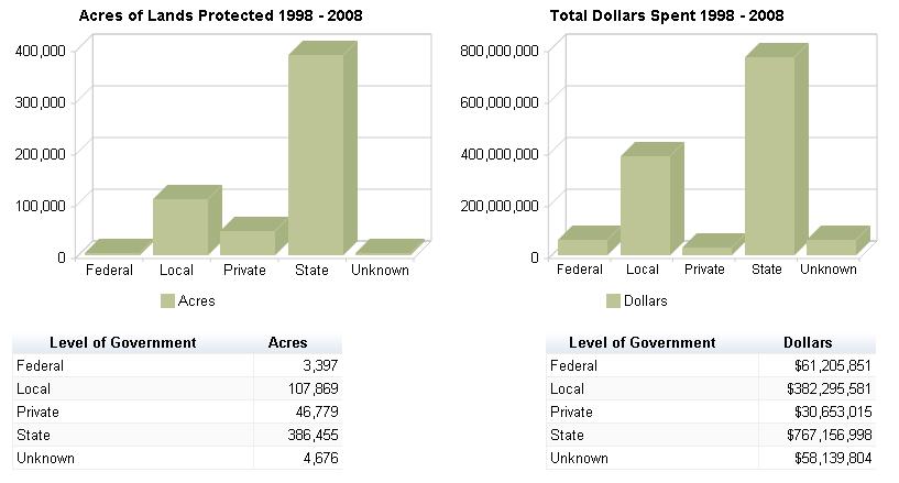
25 Sand Hills Conservation Assessment Page 25 C. State Conservation Funding Program According to TPL s Conservation Almanac, 31 which tracks conservation acquisition activity nationwide, in Pennsylvania, 538,798 acres were acquired for conservation purposes between 1998 and 2008 at a total cost of $1.1 billion. State spending by county shows that only $465,500 was spent through Keystone Recreation, Park and Conservation grants, in Dauphin County for new land acquisition, whereas $116 million was spent in Chester County, the highest spending among all counties. Other counties receiving high levels of state funding for new land acquisition include Lancaster, Berks, Northampton, Lehigh and Bucks, all of which have passed land conservation finance measures. However, between 1999 and 2010 Dauphin County received over $64 million for park development and other projects using Growing Greener funding. Only a small percentage of this was used on land conservation. The main source of federal funding to counties came from the Grassland Reserve Program, Farm and Ranch Lands Protection Program, the Land and Water Conservation Fund, the National Park Service and the Wetland Reserve Program. Counties receiving the majority of these funds were Adams, Montgomery, Pike and Chester. Between 1998 and 2008, the state spent $62 per capita on conservation, which is relatively low compared to Virginia and North Carolina, for which similar data are available. However, when viewed more broadly during the time period of , Pennsylvania ranked 6th nationally in terms of total state level spending for conservation, and 17th in terms of per capita spending as illustrated below. Land Conservation Spending & Acres Conserved using State Funds, State State $ Spent Acres Conserved $ per Capita North Carolina $1,075,500, ,262 $119 Virginia* $843,999, ,165 $109 Pennsylvania $767,156, ,455 $62 New York $1,042,649, ,601 $54 Kentucky** $46,856,559 52,839 $11 Source: TPL Conservation Almanac *Data through October 2009 **PACE Data not included for year 2008 The charts below depict the total acres acquired and total dollars spent in Pennsylvania by level of government. Data on private investment is not comprehensive. Farmland preservation programs at the county level are primarily responsible for the high level of local activity in the state ($382 million), which have helped to leverage state funds. The state Farmland Preservation Program, Growing Greener and Keystone Recreation, Park and Conservation grants have provided dedicated revenue at the state level of government. 31


26 Sand Hills Conservation Assessment Page 26
27 Sand Hills Conservation Assessment Page 27 D. State Funding Sources Pennsylvania uses direct appropriations from the General Fund, a portion of the real estate transfer tax, a state tipping fee, a portion of cigarette tax revenue, and several bonds to fund land conservation. Keystone Recreation, Park and Conservation Fund In 1993 voters passed the Key 93 initiative, which was originally funded by a 5-year, $50 million bond in addition to 15 percent of the state s share of the realty transfer tax. Key 93 focuses on land acquisition and preservation of nature preserves, habitats and parks. Grants are made through the Keystone, Recreation, Parks and Conservation Fund to The Department of Conservation and Natural Resources (65%), Pennsylvania Historic & Museum Commission (13%), Pennsylvania Department of Education (4%), and the State System of Higher Education (18%). Revenue allocated to DCNR is used for rehabilitation and upgrades to state park and forestry infrastructure, rails to trails projects, river protection and conservation projects. Grants are also distributed from DCNR to local recreation projects and to Land Trusts for natural areas and open space planning and acquisition. Between 1998 and 2008 just over $95 million was spent on land acquisition through the Keystone Recreation, Park and Conservation Fund. Growing Greener Initiative (I and II) The Growing Green I initiative, also called the Environmental Stewardship Fund, was signed into law in 1999 and dedicated nearly $650 million in bond funds over five years to preserve farmland and conserve open space. In June 2002 the Governor reauthorized the Growing Greener program, doubling the funding and extending it through This extension is funded by a permanent dedication of a $4.25/ton municipal waste disposal fee. The program s mission is to conserve farmland through the Farmland Preservation Program and open space; maintain state parks; clean up abandoned mines and restore watersheds; provide funds for recreational trails and local parks; help communities address land use; and provide new and upgraded water and sewer systems. Thus, much of the initiative is aimed at funding for projects not related to land acquisition. In May 2005 voters approved the Growing Greener II statewide bond of $625 million, nearly half of which is dedicated to the Farmland Preservation Program and open space conservation. 32 The Farmland Preservation Program was established in 1988 to curb the loss of prime farmland to non-agricultural uses. The Bureau of Farmland Preservation oversees the program, allowing for the purchase of conservation easements (i.e. development rights) from owners of valuable farmland by state, county and local governments. Funding is provided through an annual allotment of cigarette tax revenue of $ million, as well as Growing Greener bond funds. The American Farmland Trust has recognized Pennsylvania s farmland program as the leader in protecting farmland across the country, with more than 4,100 farms approved for easement purchases, totaling more than 450,000 acres. In order to qualify for the program, the land must be a part of an Agricultural Security Area (ASA), meet size specifications, have at least half of the tract be harvested cropland, pasture or grazing land, and contain 50 percent land capability classes I-IV. The farmland is scored and ranked for possible uses other than agriculture based upon a variety of factors (e.g. proximity of farm to water and sewer lines, extent and type of non-farm development 32
28 Sand Hills Conservation Assessment Page 28 nearby). Counties that decide to have an Easement Purchase Program must create an agricultural land preservation board. To date, 57 counties of 67 (85%) have established boards. In order for local governments to receive grant funding they must respond to an open application period upon notification by the state agency. Applications are ranked by regional/state staff and awarded according to internal budget priorities regarding land acquisition, restoration, recreation etc. All grants for land acquisition require a 50 percent match from local governments. 33 Growing Greener II bond funds were spread out over six years to support projects within the Department of Environmental Protection ($230 million), Department of Conservation and Natural Resources ($217.5 million), the Pennsylvania Department of Agriculture ($80 million), the Department of Community and Economic Development ($50 million), the Pennsylvania Fish and Boat Commission ($27.5 million) and the Pennsylvania Game Commission ($20 million). 34 Without re-authorization, Growing Greener II bond funds ran out in In addition, the debt service on the Growing Greener II bonds has been and continues to be drawn from the Growing Greener I Environmental Stewardship Fund. The combination of the Growing Greener II bond funds being depleted and the debt service impact on Growing Greener I has resulted in a decline in funding for Growing Greener programs from an average of $150 million annually over the past six years to $27.3 million in the current budget. Environmental Block Grant Program A provision of the Growing Greener II law established an Environmental Block Grant Program. This program allows counties to designate up to $90 million over the course of the bond program to target local priorities for open space and farmland preservation, among other purposes. State agencies were also included as a recipient of funding. Each county was guaranteed a minimum level of support and received funding according to their class Conversation with Greg Gove,, Chief, Recreation, Parks & Conservation Grants Division, Bureau of Recreation and Conservation, PA DCNR 34 Funding to the Department of Environmental Protection and the Department of Community and Economic Development do not support projects to acquire new land and little funding to the Fish and Boat Commission and Game Commission support new land acquisition. 35 The Renew Growing Greener Coalition, a statewide coalition of 23 conservation, recreation and environmental organizations formed in 2008 to plan and execute a successor Growing Greener program initiative. The coalition supports the renewal of GG initiatives with a state investment of $200 million annually, a dedicated & sustainable source or sources of revenue to support the renewal, the end of the diversion of money from the state s Environmental Stewardship Fund to pay debt on GGII bonds, and a renewed focus on conservation priorities. 36
29 Sand Hills Conservation Assessment Page 29 E. Federal Conservation Programs Through a variety of conservation programs, the federal government has long been an important partner for state and local governments, parks and conservation organizations, and community advocates. However, because of increased public and congressional scrutiny over federal spending, these programs face significant challenges each year as their budgets are proposed and finalized. For example from FY 2010 to FY 2011, the enacted level of the Land and Water Conservation Fund (LWCF) was reduced by one-third. In FY 2012, while the Obama Administration proposed full-funding of LWCF at $900 million, the House of Representatives considered a funding bill that proposed reducing LWCF to only $62 million. Other programs like the North American Wetlands Conservation Act and State Wildlife Grant programs would have seen cuts as well. Yet, when Congress completed the appropriations process for FY 2012, LWCF received $322 million, an increase from the previous year s level of $301 million, demonstrating continued bipartisan support for the program, even in difficult budget times. The precarious nature of federal spending and congressional activity has made for a very challenging political climate, yet one in which notable successes are still possible in Washington and at the special places around the country that Americans seek to conserve. Despite these potential cuts to federal conservation funding, this section of the report highlights the conservation programs that have been or are more likely to provide funding for open space acquisition. Highlands Conservation Act Federal The Highlands Conservation Act (HCA) was passed in November 2004 and, recognizes the importance of the water, forest, agricultural, wildlife, recreational, and cultural resources of the Highlands region, and the national significance of the Highlands (PA, NJ, NY, CT) region to the United States. The Act authorizes Congress to appropriate $110 million, $10 million a year over ten years for land conservation in the 4 Highlands states as well as $10 million, $1 million a year over ten years for technical assistance and study by the USFS. The HCA is currently funded through the Land and Water Conservation Fund federal side, through the U.S. Fish and Wildlife Service. A 50 percent match is required from non-federal sources, which can include state and local funds. America s Great Outdoors Initiative The Obama Administration launched the America s Great Outdoors (AGO) Initiative in April The initiative aims to reconnect Americans, and children in particular, to the outdoors by adopting a modernized approach to conservation. The initiative will reorganize and strengthen existing federal government programs and policies in coordination with state, local, tribal and private partners. Rather than dictating policies, the initiative relies on a grassroots model incorporating community ideas for conservation initiatives. Conservation targets range across the entire spectrum of land conservation--from access and transportation trails to urban parks to national parks. The Department of the Interior, Department of Agriculture, Department of the Army, Department of Commerce, and the White House Council on Environmental Quality recently signed a Memorandum of Understanding to establish the Federal Interagency Council on Outdoor Recreation (FICOR). FICOR aims to coordinate agency policy and action pertaining to the initiative; to align policies and procedures among federal, state, local, tribal and other outdoor recreation
30 Sand Hills Conservation Assessment Page 30 providers; and to identify partners outside the federal government who can promote outdoor recreation and provide additional resources and access. 37 One of the goals of the AGO initiative will be to create and enhance a new generation of safe, clean, accessible great urban parks and community green spaces. 38 This goal is to be accomplished by increased funding for the Land and Water Conservation Fund; supporting federal programs aimed to promote urban parks and community green spaces including those of the Department of Housing and Urban Development, the Department of Transportation, and the Environmental Protection Agency; targeting technical assistance to support community efforts through programs such as the Forest Service s Urban and Community Forestry Program; and connecting people with urban parks and community green spaces through programs such as the Department of Transportation s Safe Pathways to Schools. 39 One major strategy that was introduced in the initiative was the establishment of great urban parks through a portion of the LWCF for urban parks and broadening guidelines for state comprehensive outdoor recreation plans to support urban parks and green spaces. Accordingly, the President s FY 2012 budget included $122 million from LWCF state conservation grants to develop a competitive component targeted at community parks and green spaces, landscape-style conservation, and recreational waterways. The goal of these grants would be to fund signature projects that create more outdoor recreation opportunities and conserve open space in cities where access to natural areas has been unavailable. The Department of Interior is finalizing the details of this effort with the guidance of state and local park and recreation directors, state outdoor recreation liaisons, and conservation nonprofit organizations. Land and Water Conservation Fund Department of the Interior (varies by agency) Created in 1964, the Land and Water Conservation Fund (LWCF) is the largest source of federal money for park, wildlife, and open space land acquisition. Specifically, LWCF provides funding to assist in acquiring, preserving, developing and assuring accessibility to outdoor recreation resources, including but not limited to open space, parks, trails, wildlife lands and other lands and facilities desirable for individual active participation. 40 The program s funding comes primarily from offshore oil and gas drilling receipts, with an authorized expenditure of $900 million each year, while federal recreation fees, sales of federal surplus real property, and federal motorboat fuel taxes fund also contribute to the LWCF. Under this program, a portion of the money is intended to go to federal land purchases and a portion to the states as matching grants for land protection projects. Acquisitions at federal units must be within the boundaries of the national park or national wildlife refuge. The distribution of federal funds can be determined by Congress or by the federal agencies depending upon the manner provided by Congress. Most often Congress will specify the 37 Promoting-Outdoor-Recreation.cfm 38 America s Great Outdoors: A Promise to Future Generations, February 2011, available at at America s Great Outdoors: A Promise to Future Generations, February 2011, available at at <
31 Sand Hills Conservation Assessment Page 31 units and amounts identified for LWCF funding. In years when Congress passes a continuing resolution, as in FY 2007 and FY 2011, allocations are determined by the federal agency. In both cases, and depending on the overall amount of funding provided, the competition for LWCF money is very high. The proposed House Appropriations bill for FY 2012 sought to cut funding to the Land and Water Conservation Fund by more than 80 percent to $62 million. However, the President s America s Great Outdoors recommended full $900 million funding of LWCF programs in the Departments of the Interior and Agriculture. LWCF Appropriations ($ millions) Fiscal year Appropriation * *As enacted under the continuing resolution. Source: LWCF Coalition, General Factsheet.pdf. LWCF State Assistance Grants National Park Service The LWCF state assistance grants program provides a 50 percent match to states for planning, developing and acquiring land and water areas for natural resource protection and recreation enhancement. Funds are distributed through the National Park Service by a formula based on population and other factors. Once the funds are distributed to the states, it is up to each LWCF Stateside Grants to Pennsylvania FY 2011 $1,203,105 FY 2010 $1,232,328 FY 2009 $625,316 FY 2008 $763,175 FY 2007 $925,319 state to choose the projects, though the National Park Service has final approval. Eligible grant recipients include municipal subdivisions, state agencies and tribal governments, each of whom must provide at least 50 percent matching funds in either cash or in-kind contributions and a detailed plan for the proposed project. Grant applications are evaluated based on the technical merits of the project, the public/private partnerships, and how the project addresses the identified needs and priorities of a statewide comprehensive plan. Transportation Programs U.S. Department of Transportation Multiple transportation programs exist within the federal government that are applicable to conservation. Most are provided with funds through the five-year highway authorization packages. The last was SAFETEA-LU of 2005 and previous versions include TEA-21 of 1998 and ISTEA of For many years it was possible to receive additional funds through the annual appropriations process. However, Congress has eliminated earmarks in these bills, effectively ending the designation of funds for projects in the transportation appropriations bill. Transportation Enhancements In 1991, Congress authorized ISTEA ( Ice Tea ), the Intramodal Surface Transportation Efficiency Act. This multibillion-dollar law included for the first time a federal commitment to use transportation dollars to offset negative effects of highway construction projects, such as fragmented communities and the loss of open space. This commitment is carried out through the Transportation Enhancements (TE) program, which sets aside funding for
32 Sand Hills Conservation Assessment Page 32 community-based activities, such as bicycle facilities, historic preservation, abandoned rail corridors, and scenic protection. Since Congress introduced Transportation Enhancements in 1991, over $12 billion has been invested around the country in activities such as facilities for walking and bicycling, historic preservation, scenic beautification, land acquisition, and environmental mitigation. The program is funded through state transportation agencies, most of which have identified TE coordinators. Each state set aside ten percent of its Surface Transportation Program funds for use on TE activities. The state prioritizes the twelve eligible activities, accepts applications from local governments, and distributes the funds. The basic Federal eligibility requirements for TE projects are that they be one of the 12 defined activities and are related to surface transportation. States can have additional eligibility requirements. It is important to understand each state s TE program requirements before embarking on a project application. TE funds can be distributed to state or local governments or a non-governmental organization. Congress is currently debating proposals for a replacement of SAFETEA-LU. A House proposal has made state level enhancements funding optional. The Senate had proposed to keep the requirement for a set aside in order to pass an extension of the overall authorization agreed to consider an optional plan similar to the House. While national funding may not be eliminated, some states may decide to concentrate spending in other activities and not undertake enhancements projects. 12 Eligible Transportation Enhancement Activities: 1. Pedestrian and bicycle facilities Sidewalks, walkways or curb ramps; bike lane striping, wide paved shoulders, bike parking and bus racks; off-road trails; bike and pedestrian bridges and underpasses. 2. Pedestrian and bicycle safety and educational activities Campaigns promoting safety awareness; safety training activities and classes; training materials. 3. Acquisition of scenic or historic easements and sites Acquisition of scenic lands or easements; purchase of historic properties or buildings in historic districts, including historic battlefields. 4. Scenic or historic highway programs including tourist and welcome centers Construction of turnouts and overlooks; visitor centers and viewing areas; designation signs and markers. 5. Landscaping and scenic beautification Improvements such as street furniture, lighting, public art and landscaping along travel corridors. 6. Historic preservation Preservation of buildings and facades in historic districts; restoration of historic buildings for transportation-related purposes; access improvements to historic sites. 7. Rehabilitation and operation of historic transportation buildings, structures or facilities Restoration of railroad depots, bus stations and lighthouses; rehabilitation of rail trestles, tunnels, bridges and canals. 8. Conversion of abandoned railway corridors to trails Acquisition of railroad rightsof-way; planning, design and construction of multi-use trails and rail-with-trail projects. 9. Inventory, control, and removal of outdoor advertising Billboard inventories and removal of illegal and nonconforming billboards. Inventory control may include, but not be limited to, data collection, acquisition and maintenance of digital aerial photography, video
33 Sand Hills Conservation Assessment Page 33 logging, scanning and imaging of data, developing and maintaining an inventory and control database, and hiring of outside legal counsel. 10. Archaeological planning & research Research, preservation planning and interpretation; developing interpretive signs, exhibits and guides; inventories and surveys. 11. Environmental mitigation of runoff pollution and provision of wildlife connectivity Runoff pollution studies; soil erosion controls; detention and sediment basins; river clean-ups; wildlife underpasses. 12. Establishment of transportation museums Conversion of railroad stations or historic properties into museums with transportation themes; construction of new museums; purchase of exhibit materials. General information is available at and project information is available at Safe Routes to School Program The Safe Routes to Schools Program is a Federal-Aid program of the U.S. Department of Transportation's Federal Highway Administration (FHWA). The Program was created by of SAFETEA-LU. The SRTS Program is funded at $612 million over five Federal fiscal years (FY ) and is to be administered by State Departments of Transportation (DOTs). The Program provides funds to the States to substantially improve the ability of primary and middle school students to walk and bicycle to school safely. The purposes of the program are: -to enable and encourage children, including those with disabilities, to walk and bicycle to school -to make bicycling and walking to school a safer and more appealing transportation alternative, thereby encouraging a healthy and active lifestyle from an early age; and -to facilitate the planning, development, and implementation of projects and activities that will improve safety and reduce traffic, fuel consumption, and air pollution in the vicinity (approximately 2 miles) of primary and middle schools (Grades K-8). Each State administers its own program and develops its own procedures to solicit and select projects for funding. The program establishes two distinct types of funding opportunities: infrastructure projects (engineering improvements) and non-infrastructure related activities (such as education, enforcement and encouragement programs). State Actual 2005 Actual 2006* Actual 2007 Actual 2008 Actual 2009 Actual 2010 Actual 2011 Total Pennsylvania $1,000,000 $3,345,128 $4,430,549 $5,436,148 $6,720,350 $6,720,350 $7,326,704 $34,979,229 Recreational Trails Program The Recreational Trails Program (RTP) provides funds to the States to develop and maintain recreational trails and trail-related facilities for both non-motorized and motorized recreational trail uses. The RTP is an assistance program of the Department of Transportation's Federal Highway Administration (FHWA). Federal transportation funds
34 Sand Hills Conservation Assessment Page 34 benefit recreation including hiking, bicycling, in-line skating, equestrian use, cross-country skiing, snowmobiling, off-road motorcycling, all-terrain vehicle riding, four-wheel driving, or using other off-road motorized vehicles. The RTP funds come from the Federal Highway Trust Fund, and represent a portion of the motor fuel excise tax collected from non-highway recreational fuel use: fuel used for offhighway recreation by snowmobiles, all-terrain vehicles, off-highway motorcycles, and offhighway light trucks. The RTP funds are distributed to the States by legislative formula: half of the funds are distributed equally among all States, and half are distributed in proportion to the estimated amount of non-highway recreational fuel use in each State. Each State administers its own program. In Pennsylvania the Community Conservation Partnership Program within the Department of Conservation and Natural Resources runs the program and sets policies and project eligibility requirements. In FY 2011 Pennsylvania s formula apportion was $2.411 million. In FY 2010 Pennsylvania s apportionment was $2.211 million. Grants are not often above $100,000. In Pennsylvania, much of the funding has gone towards trail projects on state lands and for winter trail activities. Brownfields Program U.S. Environmental Protection Agency If a property identified for acquisition or redevelopment is or might be a brownfields site, many programs and other benefits at the local, state and federal levels encourage its redevelopment. The Environmental Protection Agency s Brownfields Program provides direct funding to eligible entities for brownfields assessment, cleanup, revolving loans, and environmental job training. In addition, legislation signed into law in 2001 limits the liability of certain contiguous property owners and prospective purchasers of brownfields properties, and innocent landowners are also afforded liability benefits to encourage revitalization and reuse of brownfield sites. EPA s brownfields program provides several types of grants: Assessment grants provide funding for a grant recipient to inventory, characterize, assess, and conduct cleanup and redevelopment planning and community involvement related to brownfield sites. Eligible entities are states, local governments, regional planning and redevelopment agencies, and Indian tribes. An eligible entity may apply for up to $200,000 to assess a site contaminated by hazardous substances, pollutants, petroleum or contaminants co-mingled with petroleum, with a waiver up to $350,000 for site specific proposals. Such waivers must be based on the anticipated level of hazardous substances, pollutants, petroleum or contaminants (including hazardous substances co-mingled with petroleum) at a single site. Total grant fund requests must not exceed a total of $400,000 per applicant unless the applicant requests a waiver. Due to budget limitations, no entity may apply for more than $700,000 in assessment funding. Remediation grants are available for remediation of brownfield sites. These grants are limited to $200,000 per site, with no more than three applications per entity. There is a 20 percent cost-share. Eligible entities are the same as listed above for assessment grants, with the addition of nonprofit organizations, who are eligible to apply, but must
35 Sand Hills Conservation Assessment Page 35 have site control of the property. One site may qualify for two grants if pollutants include petroleum and non-petroleum contaminants. Revolving Loan Fund grants provide funding for a grant recipient to capitalize a revolving loan fund to provide sub grants to carry out cleanup activities at brownfields sites. Grants may be awarded up to $1 million per eligible entity, or a group of eligible entities, with a 20 percent cost share and a five-year time frame for completion. Eligible entities are the same as those listed under assessment grants. Annual grants are announced around October each calendar year. As noted above, the proposed fiscal year 2012 federal budget produced by the House Appropriations Committee calls for a cut to EPA funding by 18 percent, a $2.1 billion cut, to a budget of $7.15 billion ($3.8 billion below the amount requested by President Obama). However, for the most part, the core Brownfields programs funding remains intact, though the Brownfield Economic Development Initiative will be eliminated, as follows: EPA Brownfields Site Assessment and Cleanup - $10 million, same as FY 10 EPA Brownfields Assistance to the States - $49.5 million, same as FY 10 HUD Brownfields Economic Development Initiative - eliminated, a cut of $17 million from FY 10 enacted. HUD Brownfields Programs: Brownfields Economic Development Initiative (BEDI) and Section 108 Loan Program U.S. Department of Housing and Urban Development The Brownfields Economic Development Initiative (BEDI) is a competitive grant program that HUD administers to assist cities with the redevelopment of abandoned or underused industrial and commercial facilities where expansion and redevelopment is burdened by real or potential environmental contamination. The goal of BEDI is to help cities spur the return of brownfields to economic use through financial assistance to public entities to redevelop brownfields. Another goal of BEDI is to enhance the security or improve the viability of a project financed with Section 108-guaranteed loan authority. Therefore BEDI grants must be used in conjunction with Section 108-guaranteed loans. Section 108 is the loan guarantee provision of the Community Development Block Grant (CDBG) program. The BEDI funds minimize the potential loss of future CDBG allocations. Both Section 108 loans and BEDI grant funds are initially made available by HUD to public entities approved for assistance. Such public entities may re-loan the Section 108 loan proceeds and provide BEDI funds to a business or other entity to carry out an approved economic development project, or the public entity may carry out the eligible project itself. BEDI projects must increase economic opportunity for persons of low-and moderateincome or stimulate and retain businesses and jobs that lead to economic revitalization. BEDI funds have been made available on a competitive basis. BEDI and Section 108 loan eligible recipients include CDBG entitlement communities and non-entitlement communities. BEDI and Section 108 funds must be used in conjunction with the same economic development project. Non-entitlement communities are also eligible to apply for and receive grants under the BEDI program. If a non-entitlement community receives a BEDI grant and applies for
36 Sand Hills Conservation Assessment Page 36 Section 108 loan guarantee assistance, the applicable state entity is required to pledge Community Development Block Grant (CDBG) funds as partial security for the loan. Community Food Projects Competitive Grants (CFPCGP) Program U.S. Department of Agriculture Private nonprofits are eligible to apply for Community Food Projects Competitive grants. Grants are intended to help eligible private nonprofit entities in need of a one-time infusion of federal assistance to establish and carryout multipurpose community food projects. Projects are funded from $10,000 to $300,000 and from 1 to 3 years. These one-time grants require a dollar-for-dollar match in resources. The CFPCGP is designed to: Meet the needs of low-income people by increasing access to fresher, more nutritious food supplies; Increase the self-reliance of communities in providing for their own food needs; Promote comprehensive responses to local food, farm, and nutrition issues; Meets specific state, local, or neighborhood food and agricultural needs for infrastructure improvement and development; Plans for long-term solutions; and Create innovative marketing activities that benefit both agricultural producers and low-income consumers. Clean Water and Drinking Water State Revolving Funds U.S. Environmental Protection Agency The U.S. Environmental Protection Agency is charged with implementing both the Clean Water Act and the Safe Drinking Water Act, two landmark pieces of legislation whose respective goals are to clean up America s waterways and to ensure safe drinking water. Conservation is an eligible activity under both laws. Both programs utilize State Revolving Funds (SRFs) to fund projects that improve water quality and enhance drinking water supplies. Every year, Congress appropriates funds that are apportioned out to the states on a formula basis to fund the SRFs. The Florida Department of Environmental Protection administers both the Clean Water State Revolving Fund and the Drinking Water State Revolving Fund. The proposed federal budget includes $1.988 billion for the Clean Water and Drinking Water State Revolving Funds, and a $797 million cut compared to FY 2011 request (which had already been proposed for a cut by President Obama because of an infusion of stimulus funds in FY 10). CWSRF and DWSRF Appropriations (millions) Fiscal year * 10 11** CWSRF 1,347 1,350 1,341 1,342 1, , ,689 2,100 2,100 DWSRF ,829 1,387 1,387 * 2009 totals include appropriations under ARRA: $4 billion for CWSRF and $2 billion for DWSRF. ** As enacted under the continuing resolution. Source: EPA budgets FY'03-FY'12, accessed at
37 Sand Hills Conservation Assessment Page 37 Clean Water State Revolving Fund Through the Clean Water State Revolving Fund (CWSRF) program, each state maintains a revolving loan fund to provide a source of low-cost financing for a wide range of water quality infrastructure projects. The CWSRF program is available to fund a wide variety of water quality projects including all types of nonpoint source, watershed protection or restoration, and estuary management projects, as well as more traditional municipal wastewater treatment projects. Nationwide, 95 percent of these funds go toward infrastructure projects, but watershed protection projects are increasing. Federal funds must be matched by 20 percent non-federal funds. CWSRF programs operate much like environmental infrastructure banks that are capitalized with federal and state contributions. CWSRF monies are loaned to communities and loan repayments are recycled back into the program to fund additional water quality protection projects. The revolving nature of these programs provides for an ongoing funding source that will last far into the future. States have the flexibility to target resources to their particular environmental needs, including contaminated runoff from urban and agricultural areas, wetlands restoration, groundwater protection, brownfields remediation, estuary management, and wastewater treatment. Land or easement acquisition is permitted with CWSRF funds as a method to reduce nonpoint source pollution. Drinking Water State Revolving Fund The Drinking Water State Revolving Fund (DWSRF) program was established by the 1996 Safe Drinking Water Act Amendments, under which EPA provides grants to states to establish revolving loan funds from which they provide loans and other types of financial assistance to public water systems for eligible infrastructure improvements. Conservation easements and fee acquisition may be funded. Since its inception, $2.7 million has been used for the acquisition of approximately 2,000 acres of land under the DWSRF. EPA has begun a concerted effort to focus more attention on protecting source water, which is roughly defined as untreated water from streams, rivers, lakes, or underground aquifers, which is used to supply private wells and public drinking water. There is growing recognition that protecting the source from contaminants is often more efficient and costeffective than treating drinking water later. Loans under the DWSRF are typically low-interest loans which may be repaid over 20 years. There is some flexibility given to the states to allow them to waive the principal repayment, offer negative interest rates or extend the loans to 30 years in specific hardship cases. Up to 31 percent of these capitalization grants can be set-aside to administer the SRF and state source protection programs and to fund source water protection activities, including land acquisition. Up to 15 percent of the set-aside can be used for land conservation and voluntary, incentive-based protection measures, with no more than 10 percent used for a single type of activity, such as land protection. Community Development Block Grants (CDBG) U.S. Department of Housing and Urban Development The Department of Housing and Urban Development provides Entitlement Communities Grants for the principal cities of Metropolitan Statistical Areas (MSAs), other metropolitan cities with populations of at least 50,000; and qualified urban counties with populations of
38 Sand Hills Conservation Assessment Page 38 at least 200,000 (excluding the population of entitled cities). CDBG funds may be used for activities that include, but are not limited to acquisition of real property; relocation and demolition; and construction of public facilities and improvements, such as water and sewer facilities, streets, neighborhood centers, and the conversion of school buildings for eligible purposes. HUD awards grants to entitlement community grantees to carry out a wide range of community development activities directed toward revitalizing neighborhoods, economic development, and providing improved community facilities and services. Entitlement communities develop their own programs and funding priorities. However, grantees must give maximum feasible priority to activities which benefit low- and moderate-income persons. A grantee may also carry out activities which aid in the prevention or elimination of slums or blight. Additionally, grantees may fund activities when the grantee certifies that the activities meet other community development needs having a particular urgency because existing conditions pose a serious and immediate threat to the health or welfare of the community where other financial resources are not available to meet such needs. CDBG funds may not be used for activities which do not meet these broad national objectives. Eligible grantees are as follows: Principal cities of Metropolitan Statistical Areas (MSAs); other metropolitan cities with populations of at least 50,000; and qualified urban counties with populations of at least 200,000 (excluding the population of entitled cities) are entitled to receive annual grants. HUD determines the amount of each entitlement grant by a statutory dual formula which uses several objective measures of community needs, including the extent of poverty, population, housing overcrowding, age of housing and population growth lag in relationship to other metropolitan areas. CDBG funds are allocated to states, counties and cities on a formula basis. HUD does not provide assistance directly to citizens, businesses or non-profit organizations. If you are an interested citizen, contact your local municipal or county officials for more information. It is possible that you live in a jurisdiction or area that is a direct or indirect grantee. Please check the CDBG Grantee Contacts or the CDBG Participation Directory for contact information. If your local government officials cannot answer your questions, or if you are a local official, contact the HUD Field Office that serves your area. Note that the local government administers the program and determines which local projects receive funding.
39 Sand Hills Conservation Assessment Page 39 III. Appendices Appendix A: PA Highlands Greenway Analysis Definition and GIS Methodology for Hubs and Corridors Hubs are core natural areas in the Pennsylvania Highlands and the potential connectors between them are called Corridors. Hubs are areas that have a high natural resource value such as large intact forests or abundant wildlife and, little fragmentation such as forests or farmland broken up by large developments. Hubs are both undisturbed natural lands and adjacent protected lands such as state parks, forests or game lands. Corridors are the best potential lands to connect the Hubs. While Corridors are not necessarily natural or protected lands they are important as they connect Hubs and often provide the most practical routes for animals to travel between core habitat areas. Development of Pennsylvania Highlands Greenway Hubs and Corridors : Phase one of the analysis process encompassed the development of a base layer to synthesize the natural and recreational resources targeted for conservation through the Greenway Plan. The data used in this process was obtained from the National Land Cover Dataset (NLCD). The first step involved identifying all green infrastructure grid cells. Green infrastructure consists of all thirty-meter NLCD pixels relating to forests, wetlands and open water. These three pixel values were then reclassified to equal the same value and converted to an ArcView shapefile. From this shapefile all contiguous areas totaling less than fifty hectares on the ground were removed followed by the removal of highly traveled roads. This was done to eliminate areas that are considered too small for analysis or are highly traveled and therefore do not qualify for analysis as a potential conservation area. A buffer was built around roads removing a 200 meters wide path from primary roads and a 100 meters wide path around secondary roads. These buffers act to filter the area between the roads and the natural areas to be studied. Multipart shapes were converted onto a single part and all shapes were then dissolved into one shape based on the Gridcode field in the attributes table. This shape was then converted back to raster format. The second step of the analysis was to further narrow the targeted natural resources through what is known as a stronghold analysis. A stronghold analysis consolidates the natural resource areas in the base composite resource data layer by identifying those areas least affected by surrounding and fragmenting disturbances such as roads. The stronghold analysis was performed in two steps. The first step was to shrink the hub lands grid and perform an aggregate analysis with the properties 1/aggreg/10/min/yes/yes performed stronghold type A. The second step was performed by shrinking the hub lands grid and performing an aggregate analysis with the properties 1/aggreg/3/min/yes/yes. Both analyses were converted to shapefiles and sliver polygons under 10 hectares were eliminated.
40 Sand Hills Conservation Assessment Page 40 Type A strongholds greater than 20 hectares were combined with type B strongholds occurring within 300 meters of type A strongholds, resulting in the creation of aggregated stronghold hub lands that highlight distinct regions. The resulting areas have high natural resource values and are minimally fragmented by built disturbances. The third step was to do a nearest neighbor analysis that would further smooth and unite intact natural resource areas such as interior forests, and give higher priority to those areas closest to existing public lands and private protected lands. This was intended to prioritize and highlight those areas where new land conservation can augment already protected lands. The nearest neighbor analysis was performed on the stronghold hubs based on the mean and 300m group and a shrink was performed on the resulting grids to match the boundary of the initial analysis and then reclassified. Protected lands were buffered by 10 grid cells and given a value of 10. This assured that those existing protected areas would receive highest priority in our development of conservation core areas and nodes. The fourth and final step was to integrate Natural Lands Trust s Smart Conservation to capture the highest priority ecological lands. Smart Conservation combines numerous data layers, pertaining to ecological richness, into a composite portrait of which lands are most essential for maintaining biological diversity. This was achieved by overlaying the stronghold analysis data with Smart Conservation ecological data, consisting of a potential vertebrates habitat subgroup, an aquatic habitat subgroup and a terrestrial habitat subgroup. A nearest neighbor analysis of 1000m was performed on the resulting overlay. An expand by ten on the top twenty-five percent quantile was performed to identify the hubs while a shrink by ten on the top fifty percent quantile was performed to identify the corridors. These hubs and corridors were then overlaid and converted to a shapefile. The final result of the completed analysis is a composite hub and spoke greenway scheme that can guide future conservation of the region. Given the many data layers and techniques employed to create this greenway plan, the final product represents a blueprint for conserving a wide range of natural and recreational resource values that include biodiversity, water supplies, and outdoor recreation. If the Pennsylvania Highlands Greenway Map vision is successfully implemented, it will have a lasting impact on the quality of life for the entire region.

41 Sand Hills Conservation Assessment Page 41 Appendix B: Location Maps Map 1: Study Area Map 2: Sand Hills Conservation Focus Area

42 Map 3: Dauphin County Study Area Sand Hills Conservation Assessment Page 42


43 Sand Hills Conservation Assessment Page 43 Appendix C: Components Map 1: Composite Resource Values Map 2: Recreational/Cultural Resource Values
44 Sand Hills Conservation Assessment Page 44 Map 3: Water Resource Values Map 4: Biological Resource Values
45 Sand Hills Conservation Assessment Page 45 Map 5: Agricultural Resource Values Map 6: Forest Resource Values

46 Sand Hills Conservation Assessment Page 46 Table 1 PA Highlands Resource Components U.S. Department of Agriculture, Forest Service Highlands Regional Study: Connecticut and Pennsylvania 2010 Update. Table PA-1, page

47 Sand Hills Conservation Assessment Page 47


48 Map 7: Recreation Trails Sand Hills Conservation Assessment Page 48
49 Sand Hills Conservation Assessment Page 49 Map 8: AMC Greenway Corridors Map 9: AMC Recreation Corridor

50 Sand Hills Conservation Assessment Page 50 Map 10: Pennsylvania Natural Heritage Program Core Habitat Map 11: Pennsylvania Natural Heritage Program Supporting Landscape
51 Sand Hills Conservation Assessment Page 51 Map 12: Riparian Areas Map 13: Impaired and Non-Impaired Streams

52 Sand Hills Conservation Assessment Page 52 Appendix D: Results Map 1: Protected Lands
CONSERVATION FINANCE FEASIBILITY STUDY JUNE 2018 WESTTOWN TOWNSHIP, PENNSYLVANIA
 CONSERVATION FINANCE FEASIBILITY STUDY JUNE 2018 WESTTOWN TOWNSHIP, PENNSYLVANIA Copyright June 2018,The Trust for Public Land. All rights reserved. Cover photo: Crebilly Farm Photo Credit: Save Crebilly
Improvements to the Open Space Law: What You Need to Know
 Improvements to the Open Space Law: What You Need to Know To what lengths would you go to save open space? Background & Intention: Legislation Enacted, Development Pressure Increases Appetite Open Space
More than 2,300 acres.
 FUNDING LAND CONSERVATION PRESERVING LAND Northampton County Townships Find Formula That Works for Land Conservation Many rural townships, feeling the pressure to develop open space, want to be able to
OPEN SPACE & RECREATION PLAN
 OPEN SPACE & RECREATION PLAN HOPEWELL TOWNSHIP Cumberland County, New Jersey Prepared by: Hopewell Township Environmental Commission Final October 2011 (THIS PAGE INTENTIONALLY LEFT BLANK) PUBLIC MEETINGS
2018 Highlands Region Land Preservation Status Report
 2018 Highlands Region Land Preservation Status Report Highlands Development Credit (HDC) properties (l to r): Tewksbury Township, Hunterdon County; Mount Olive, Morris County; Independence Township, Warren
Land Preservation in the Highlands Region
 Land Preservation in the Highlands Region Prepared by the Highlands Water Protection and Planning Council - August 2010 The Highlands watersheds are the best in the State in respect to ease of collection,
SESSION OF 1993 Act No AN ACT TABLE OF CONTENTS
 Official Advance Copy SESSION OF 1993 Act 1993-50 359 No. 1993-50 AN ACT HB 52 Providing for the establishment, operation and administration of the Keystone Recreation, Park and Conservation Fund; designating
Midway City Council 2 October 2018 Regular Meeting. Issuance of General Obligation Bonds / Public Meeting
 Midway City Council 2 October 2018 Regular Meeting Issuance of General Obligation Bonds / Public Meeting Memo Date: 29 September 2018 To: Mayor, City Council and Staff Cc: File From: Brad Wilson, City
General Development Plan Background Report on Agricultural Land Preservation
 General Development Plan 2008 Background Report on Agricultural Land Preservation February 2008 I. Introduction Anne Arundel County has been an agricultural community for over 350 years, beginning with
TOWN OF PELHAM, NEW HAMPSHIRE
 TOWN OF PELHAM, NEW HAMPSHIRE BUILDOUT ANALYSIS Prepared for the PELHAM CONSERVATION COMMISSION with the assistance of the NASHUA REGIONAL PLANNING COMMISSION TABLE OF CONTENTS I. INTRODUCTION...1 II.
2016 Highlands Region Land Preservation Status Report
 State of New Jersey Highlands Water Protection and Planning Council 100 North Road (Route 513) Chester, New Jersey 07930-2322 (908) 879-6737 (908) 879-4205 (fax) www.nj.gov/njhighlands 2016 Highlands Region
THE MANADA CONSERVANCY
 THE MANADA CONSERVANCY Description of a Land Trust What is a land trust? Land Trusts are non-profit organizations which work hand-in-hand with landowners to protect open spaces increasingly threatened
Existing Land Use. Typical densities for single-family detached residential development in Cumberland County: 1
 Existing Land Use A description of existing land use in Cumberland County is fundamental to understanding the character of the County and its development related issues. Economic factors, development trends,
Central Pennsylvania Conservancy Project Selection Criteria Form
 Central Pennsylvania Conservancy Project Selection Criteria Form The following criteria guide the actions of the Central Pennsylvania Conservancy s Land Protection Committee and Board of Directors in selecting
CODING: Words stricken are deletions; words underlined are additions. hb er
 1 2 3 4 5 6 7 8 9 10 11 12 13 14 15 16 17 18 19 20 21 22 23 24 25 26 An act relating to local government environmental financing; providing a short title; amending s. 212.055, F.S.; expanding the uses
National Legislative Program Evaluation Society September 19, Pennsylvania Legislative Budget and Finance Committee
 National Legislative Program Evaluation Society September 19, 2011 House Resolution 2009-334 Study the systems of real property valuation and assessment Pennsylvania Other states, in particular Maryland
OPEN SPACE PRESERVATION. Reflections on the Value of Acquiring Property for Preservation Purposes
 OPEN SPACE PRESERVATION Reflections on the Value of Acquiring Property for Preservation Purposes What is open space and what does it do? The Town Plan of Conservation and Development defines it as follows:
Dakota County Farmland and Natural Areas Program. Lake Pepin TMDL May 31, 2007
 Dakota County Farmland and Natural Areas Program Lake Pepin TMDL May 31, 2007 Presentation Overview County Context FNAP Planning Process FNAP Implementation Integrating Conservation Efforts Parcel Development
Opportunity Knocks. Open Space as acommunity Investment. By Michael Frank
 Opportunity Knocks Open Space as acommunity Investment By Michael Frank Acknowledgements This Project was made possible through a legislative initiative grant from Representative Charles T. McIlhinney
Understanding. Clean and Green
 Understanding Clean and Green Lycoming County Assessment Office 48 West Third Street Williamsport PA 17701 (570) 327-2301 DISCLAIMER: The material contained in this booklet is intended to provide only
Kent Land Trust Strategic Reassessment Project Final Report
 Kent Land Trust Strategic Reassessment Project Final Report Prepared For: Connecticut Institute for Resilience and Climate Adaptation (CIRCA) Prepared by: Michael A. Benjamin, Land Steward, Kent Land Trust
Community Preservation Act Answers To Frequently Asked Questions
 Community Preservation Act Answers To Frequently Asked Questions On September 14, 2000, former Governor Paul Cellucci and Lieutenant Governor Jane Swift signed the Community Preservation Act into law.
Amendment 1 Sponsor Committee Water and Land Conservation Amendment (850)
") ! Amendment 1 Text Amendment 1 Sponsor Committee Water and Land Conservation Amendment (850) 629-4656 emailus@floridawaterlandlegacy.org www.floridawaterlandlegacy.org TITLE: Water and Land Conservation
! Amendment 1 Text Amendment 1 Sponsor Committee Water and Land Conservation Amendment (850) 629-4656 emailus@floridawaterlandlegacy.org www.floridawaterlandlegacy.org TITLE: Water and Land Conservation
Town of Windham. Planning Department 8 School Road Windham, ME Voice ext. 2 Fax
 Town of Windham Planning Department 8 School Road Windham, ME 04062 Voice 207.894.5960 ext. 2 Fax 207.892.1916 Comprehensive Plan Review Team #12 RSU Superintendents Office Building, 1 st Floor Conference
Title 5: ADMINISTRATIVE PROCEDURES AND SERVICES
 Title 5: ADMINISTRATIVE PROCEDURES AND SERVICES Chapter 353: LAND FOR MAINE'S FUTURE Table of Contents Part 15-A. LAND FOR MAINE'S FUTURE... Section 6200. FINDINGS... 3 Section 6201. DEFINITIONS... 3 Section
COMMUNITY PRESERVATION ACT Town of Hatfield OPEN SPACE PROJECT GUIDELINES
 COMMUNITY PRESERVATION ACT Town of Hatfield OPEN SPACE PROJECT GUIDELINES CPA Open Space Projects: The Act requires that a participating community shall spend, or set aside for later spending, not less
Land Trust of Santa Cruz County. Strategic Plan. July 2012 to June This is a public version of a more detailed internal plan.
 Land Trust of Santa Cruz County Strategic Plan July 2012 to June 2015 This is a public version of a more detailed internal plan. Over the next three years the Land Trust will pursue four critical strategies.
MITIGATION POLICY FOR DISTRICT-PROTECTED LANDS
 MITIGATION POLICY FOR DISTRICT-PROTECTED LANDS Approved by the District Board of Directors on July 18, 2017 The following Mitigation Policy is intended to inform the evaluation of environmental mitigation-related
Land Use. Land Use Categories. Chart 5.1. Nepeuskun Existing Land Use Inventory. Overview
 Land Use State Comprehensive Planning Requirements for this Chapter A compilation of objectives, policies, goals, maps and programs to guide the future development and redevelopment of public and private
Chapter 10 Local Protection Measures
 The DPC fully supports the protection of private property rights and the DPC will work to ensure that there will be no negative impacts stemming from NHA activities on private property, should the designation
Protecting Farmland in Maryland: A Review of the Agricultural Land Preservation Program
 Protecting Farmland in Maryland: A Review of the Agricultural Land Preservation Program Craig Shollenberger Planning Intern (former) Anne Arundel County Maryland INTRODUCTION During the past ten to twelve
Innovative Local Government Land Conservation Techniques
 Innovative Local Government Land Conservation Techniques Three new successful land conservation programs used in Maryland by Baltimore and Carroll Counties are worthy of further examination. Baltimore
Palmerton Area Comprehensive Plan
 DRAFT Palmerton Area Comprehensive Plan Bowmanstown Borough, Lower Towamensing Township, Palmerton Borough and Towamensing Township Carbon County, Pennsylvania Draft - With Minor Revisions - March 2008
REVENUE ESTIMATING CONFERENCE TAX: ISSUE:
 REVENUE ESTIMATING CONFERENCE TAX: Ad Valorem ISSUE: Millage rate cap of 13.5 mills (1.35%) on all real property BILL NUMBER(S): HB 385 SPONSOR(S): Rivera MONTH/YEAR COLLECTION IMPACT BEGINS: DATE OF ANALYSIS:
Understanding Mississippi Property Taxes
 Understanding Mississippi Property Taxes Property tax revenues are a vital component of the budgets of Mississippi s local governments. Property tax revenues allow these governments to provide important
DESCRIPTION OF A LAND TRUST
 DESCRIPTION OF A LAND TRUST What is a land trust? Land trusts are non-profit organizations that work hand-in-hand with landowners to protect our valuable natural resources. Land trusts have become increasingly
CHAPTER Committee Substitute for Committee Substitute for House Bill No. 447
 CHAPTER 2016-225 Committee Substitute for Committee Substitute for House Bill No. 447 An act relating to local government environmental financing; providing a short title; amending s. 212.055, F.S.; expanding
Introduction to INRMP Implementation Options
 El Dorado County Integrated Natural Resources Management Plan Introduction to INRMP Implementation Options 1 Our approach to the options evaluation is based on the INRMP components as they are currently
Midway City Council 4 December 2018 Regular Meeting. Ordinance / General Plan Amendment
 Midway City Council 4 December 2018 Regular Meeting Ordinance 2018-23 / General Plan Amendment CITY COUNCIL MEETING STAFF REPORT DATE OF MEETING: December 4, 2018 DOCUMENT: NAME OF APPLICANT: AGENDA ITEM:
CHAPTER 12. BE IT ENACTED by the Senate and General Assembly of the State of New Jersey:
 CHAPTER 12 AN ACT concerning the constitutional dedication of corporation business tax revenues for certain environmental purposes, supplementing Title 13 of the Revised Statutes, and amending P.L.1999,
Midway City Council 16 October 2018 Work Meeting. Ordinance / General Plan Amendment
 Midway City Council 16 October 2018 Work Meeting Ordinance 2018-23 / General Plan Amendment CITY COUNCIL MEETING STAFF REPORT DATE OF MEETING: October 16, 2018 DOCUMENT: NAME OF APPLICANT: AGENDA ITEM:
Understanding the Clean and Green Program
 Understanding the Clean and Green Program Perry County, Pennsylvania DISCLAIMER: The material contained in this document is intended to provide only general information concerning the Pennsylvania Farmland
IRS FORM 8283 SUPPLEMENTAL STATEMENT DONATION OF CONSERVATION EASEMENT
 Name(s) shown on income tax return Identifying Number Robert T. Landowner 021-34-1234 Susan B. Landowner 083-23-5555 IRS FORM 8283 SUPPLEMENTAL STATEMENT DONATION OF CONSERVATION EASEMENT On November 12,
LEGISLATIVE PURPOSES. 2. Provide sources of agricultural products within the state for the citizens of the state
 LEGISLATIVE PURPOSES 1. Assist in sustaining the farming community 2. Provide sources of agricultural products within the state for the citizens of the state 3. Control the urban expansion which is consuming
DEVELOPING LOCAL FUNDING TO PROTECT DRINKING WATER SOURCES IN NORTH CAROLINA A GUIDE FOR LOCAL GOVERNMENT OFFICIALS
 DEVELOPING LOCAL FUNDING TO PROTECT DRINKING WATER SOURCES IN NORTH CAROLINA A GUIDE FOR LOCAL GOVERNMENT OFFICIALS Prepared by The Trust for Public Land October 2010 INTRODUCTION This guide is designed
HERSHEY COMMUNITY CENTER
 HERSHEY COMMUNITY CENTER Revised October 5, POTENTIAL HERSHEY COMMUNITY CENTER OVERVIEW ABOUT THE COMMUNITY CENTER Since our recreation center was built in 1963, our community and its recreation needs
AGENDA SHEET FOR COMMISSIONER S MEETING OF: December 7th, 2010
 AGENDA SHEET FOR COMMISSIONER S MEETING OF: December 7th, 2010 SUBMITTING DEPARTMENT: Parks, Recreation & Golf CONTACT PERSON: Doug Chase PHONE NUMBER: 477-2720 CHECK TYPE OF MEETING ITEM BELOW: BELOW
Community Based Public Private Partnership (CBP3) Great Lakes & St Lawrence Cities Initiatives
 Great Lakes & St Lawrence Cities Initiatives") Community Based Public Private Partnership (CBP3) Great Lakes & St Lawrence Cities Initiatives COMMON REASONS FOR PARTNERING Purpose Create long-term value by solving the essential problems you can t solve
Community Based Public Private Partnership (CBP3) Great Lakes & St Lawrence Cities Initiatives COMMON REASONS FOR PARTNERING Purpose Create long-term value by solving the essential problems you can t solve
Clean and Green LEBANON COUNTY UNDERSTANDING THE PROGRAM
 LEBANON COUNTY UNDERSTANDING THE Clean and Green PROGRAM When a county implements a Clean and Green program, it places two values on each parcel of land that qualifies. These values are known as the Fair
PUBLIC NOTICE TO HUNTERDON COUNTY VOTERS NOTICE OF GENERAL ELECTION
 PUBLIC NOTICE TO HUNTERDON COUNTY VOTERS NOTICE OF GENERAL ELECTION A General Election will be held on November 4, 2008 between the hours of 6:00AM and 8:00PM. The several State, County and local positions
Land Conservation Acreage Milestones
 Land Conservation Acreage Milestones Acreage goals set a milestone to achieve and a sense of accomplishment when they are reached. Ultimately, they are used as a measure of program success. Below are some
Town of Falmouth s Four Step Design Process for Subdivisions in the Resource Conservation Zoning Overlay District
 Town of Falmouth s Four Step Design Process for Subdivisions in the Resource Conservation Zoning Overlay District All subdivisions shall be designed in accordance with the following four-step process.
Conservation Easement Stewardship
 Conservation Easements are effective tools to preserve significant natural, historical or cultural resources. Conservation Easement Stewardship Level of Service Standards March 2013 The mission of the
Open Space. Introduction. Vision. Defining Open Space. Midway City 2017 General Plan
 Open Space Midway City 2017 General Plan Introduction The importance of preserving open space to meet the goals and objectives of the General Plan cannot be overstated. Indeed, references to preserving
Claudia Stuart, Williamson Act Program Manager and Nick Hernandez, Planning Intern
 Land Conservation (Williamson) Act Advisory Committee STAFF REPORT September 15, 2014 Prepared by: Claudia Stuart, Williamson Act Program Manager and Nick Hernandez, Planning Intern Subject: Discussion:
PLANNING FOR OUR FUTURE
 PLANNING FOR OUR FUTURE ELLSWORTH TOWNSHIP LAND USE AND POLICY PLAN The purpose of this Plan is to serve as a guide for the Township Trustees, Zoning Commission, Board of Zoning Appeals, developers, employers,
SARASOTA COUNTY GOVERNMENT
 SARASOTA COUNTY GOVERNMENT Parks, Recreation and Natural Resources TO: Sarasota County Commission THROUGH: Jonathan R. Lewis, County Administrator FROM: Carolyn Brown, Director, Parks, Recreation and Natural
Transfer of Development Rights (TDR) in Practice
 in Practice") Transfer of Development Rights (TDR) in Practice Transfer of Development Rights (TDR) programs use market forces to simultaneously promote conservation in high value natural, agricultural, and open space
Transfer of Development Rights (TDR) in Practice Transfer of Development Rights (TDR) programs use market forces to simultaneously promote conservation in high value natural, agricultural, and open space
UNOFFICIAL COPY OF HOUSE BILL 1272 A BILL ENTITLED
 UNOFFICIAL COPY OF HOUSE BILL 1272 M4 6lr0525 By: Delegates Smigiel, Kelley, Rosenberg, and Sossi Introduced and read first time: February 10, 2006 Assigned to: Environmental Matters 1 AN ACT concerning
SENATE BILL No. 35. December 5, 2016
 AMENDED IN ASSEMBLY JULY 5, 2017 AMENDED IN ASSEMBLY JUNE 20, 2017 AMENDED IN SENATE MAY 26, 2017 AMENDED IN SENATE APRIL 4, 2017 AMENDED IN SENATE MARCH 21, 2017 AMENDED IN SENATE MARCH 9, 2017 AMENDED
Appendix J Agricultural Land Preservation in Other States
 Appendix J Agricultural Land Preservation in Other States Appendix J Agricultural land preservation in other states Many states across the U.S. are working to protect agricultural land from development.
Please review the Draft PTF Grant Manual with the above background information in mind. AGC
 Board of Trustees Anna G. Chisholm, PTF Program Administrator 3.15.2017 Proposed Updates to the PTF Grant Manual The PTF Grant Manual was last updated in 2006 and many details of the easement process have
The Local Government Fiscal Impacts of Land Uses in Union County:
 The Local Government Fiscal Impacts of Land Uses in Union County: Revenue and Expenditure Streams by Land Use Category Jeffrey H. Dorfman and Bethany Lavigno Department of Agricultural & Applied Economics
2014 Plan of Conservation and Development
 The Town of Hebron Section 1 2014 Plan of Conservation and Development Community Profile Introduction (Final: 8/29/13) The Community Profile section of the Plan of Conservation and Development is intended
SCHOOL FINANCE: IMPACT FEES and a COUPLE OF OTHER THINGS. First Things. How Do We Pay? What Are We Talking About? How Do We Pay?
 SCHOOL FINANCE: IMPACT FEES and a COUPLE OF OTHER THINGS Theodore B. DuBose Haynsworth Sinkler Boyd, P.A. Presented to: SC School Boards Association 2016 School Law Conference Charleston, South Carolina
Local and Federal Funding for Mainland Beach Restoration Projects
 Local and Federal Funding for Mainland Beach Restoration Projects Presented by: Andrew Wycklendt (CB&I) Hawaii Shore and Beach Preservation Association 2014 Beach Restoration Workshop November 24, 2014
Chapter XX Purchase of Development Rights Program
 Chapter XX Purchase of Development Rights Program Short Title. This ordinance is to be known and may be cited as the Purchase of Development Rights ( PDR ) Program. Purpose Pursuant to the authority granted
Office of Legislative Services Background Report The Assessment of Real Property: Answers to Frequently Asked Questions
 Office of Legislative Services Background Report The Assessment of Real Property: Answers to Frequently Asked Questions OLS Background Report No. 120 Prepared By: Local Government Date Prepared: New Jersey
85 Old Dublin Pike. Doylestown, PA Preserving Our Natural and Historic Heritage (215)
") 85 Old Dublin Pike Preserving Our Natural and Historic Heritage Doylestown, P 18901 (215) 345-7020 Heritage Conservancy is a full service conservation organization with over 50 years of professional experience.
85 Old Dublin Pike Preserving Our Natural and Historic Heritage Doylestown, P 18901 (215) 345-7020 Heritage Conservancy is a full service conservation organization with over 50 years of professional experience.
Comprehensive Plan 2030
 Introduction The purpose of this chapter of the Comprehensive Plan is to accurately describe, in words and images, the goals and visions for the future of Clearfield, as determined by the people who live
Wildlife Habitat Conservation and Management Program
 EXHIBIT 1 PC-2015-4106 ODFW Guide Wildlife Habitat Conservation and Management Program Manual for Counties and Cities Oregon Department of Fish and Wildlife March 2006 Table of Contents 1. Introduction
Pennsylvania Tax Credit Rental Housing Survey
 2012 Pennsylvania Tax Credit Rental Housing Survey 155 East Columbus Street Suite 220 Pickerington, OH 43147 Bowen National Research conducted a statewide survey of approximately 65% of Tax Credit rental
SERVICE PLAN FOR RIVER VALLEY VILLAGE METROPOLITAN DISTRICT[S] CITY OF THORNTON, COLORADO. Prepared [NAME OF PERSON OR ENTITY] [ADDRESS] [ADDRESS]
![SERVICE PLAN FOR RIVER VALLEY VILLAGE METROPOLITAN DISTRICT[S] CITY OF THORNTON, COLORADO. Prepared [NAME OF PERSON OR ENTITY] [ADDRESS] [ADDRESS]](/thumbs/95/124551086.jpg "SERVICE PLAN FOR RIVER VALLEY VILLAGE METROPOLITAN DISTRICT[S] CITY OF THORNTON, COLORADO. Prepared [NAME OF PERSON OR ENTITY] [ADDRESS] [ADDRESS]") 2007 Thornton model service plan UPDATED August 2009 SERVICE PLAN FOR RIVER VALLEY VILLAGE METROPOLITAN DISTRICT[S] CITY OF THORNTON, COLORADO Prepared by [NAME OF PERSON OR ENTITY] [ADDRESS] [ADDRESS]
2007 Thornton model service plan UPDATED August 2009 SERVICE PLAN FOR RIVER VALLEY VILLAGE METROPOLITAN DISTRICT[S] CITY OF THORNTON, COLORADO Prepared by [NAME OF PERSON OR ENTITY] [ADDRESS] [ADDRESS]
CHARTER TOWNSHIP OF FENTON SEWER SYSTEM FINANCIAL OVERVIEW MARCH, 2018
 CHARTER TOWNSHIP OF FENTON SEWER SYSTEM FINANCIAL OVERVIEW MARCH, 2018 Fenton Township continues to receive inquiries regarding the relatively high sewer use fees that Township residents have been paying
Understanding the Clean and Green Program
 Understanding the Clean and Green Program Venango County, Pennsylvania DISCLAIMER: The material contained in this booklet is intended to provide only general information concerning the Pennsylvania Farmland
OPEN-SPACE CONVERSION REQUEST
 OPEN-SPACE CONVERSION REQUEST Applicant: Board Meeting: February 9, 2017 Landowner: Normandy Capital, LLC VOF Easement: BAT-03678 Table of Contents: Cover Page 1 Table of Contents 2 Application Overview
CHAPTER 7 HOUSING. Housing May
 CHAPTER 7 HOUSING Housing has been identified as an important or very important topic to be discussed within the master plan by 74% of the survey respondents in Shelburne and 65% of the respondents in
BLAIR COUNTY. UNDERSTANDING THE Clean and Green PROGRAM. COUNTY OF BLAIR Blair County Courthouse 423 Allegheny Street Hollidaysburg, PA
 BLAIR COUNTY UNDERSTANDING THE Clean and Green PROGRAM When a county implements a Clean and Green program, it places two values on each parcel of land that qualifies. These values are known as the Fair
Understanding. Clean and Green. Lycoming County Assessment Office 48 West Third Street Williamsport PA (570)
") Understanding Clean and Green Lycoming County Assessment Office 48 West Third Street Williamsport PA 17701 (570) 327-2301 DISCLAIMER: The material contained in this booklet is intended to provide only
Understanding Clean and Green Lycoming County Assessment Office 48 West Third Street Williamsport PA 17701 (570) 327-2301 DISCLAIMER: The material contained in this booklet is intended to provide only
REAL PROPERTY TAX BASE, MARKET VALUES, AND MARCELLUS SHALE: 2007 TO 2009
 CENTER FOR ECONOMIC AND COMMUNITY DEVELOPMENT REAL PROPERTY TAX BASE, MARKET VALUES, AND MARCELLUS SHALE: 2007 TO 2009 TIMOTHY W. KELSEY, RILEY ADAMS, AND SCOTT MILCHAK MARCH 1, 2012 CECD RESEARCH PAPER
Lessard Sams Outdoor Heritage Council
 Lessard Sams Outdoor Heritage Council MEMO: Agenda Item # 10 DATE: December 11, 2014 SUBJECT: PRESENTER: 2015 Legislative Appropriation Recommendation Bill Heather Koop, LSOHC staff Background: On October
January 28, Parcel sale. Proposed Clarks Creek Property Sale. Potential sale of acres 8/27/2015
 Proposed Clarks Creek Property Sale January 28, 2015 Potential sale of 383.8 acres CRW The Conservation Fund PA Game Commission The Conservation Fund is Fort Indiantown Gap selected partner Using Fort
Validation Checklist. Date submitted: How to use this check-list. Ecosystem Credit Accounting System. Version 1.1&2. Project Information
 Ecosystem Credit Accounting System Version 1.1&2 Last updated April 21, 2017 Validation Checklist Date submitted: Project Information Project Name Trading Area Name Trading Area Type (e.g., TMDL, TNC Ecoregion)
EXPLANATION OF COLUMN HEADINGS
 American farmland trust Farmland information center DESCRIPTION FARMLAND INFORMATION CENTER FACT SHEET STATUS OF LOCAL PACE PROGRAMS One Short Street, Suite 2 Northampton, MA 01060 (800) 370-4879 www.farmlandinfo.org
published by The Trust for Public Land and Land Trust Alliance Americans Invest in Parks & Conservation LandVote 2009
 published by The Trust for Public Land and Land Trust Alliance Americans Invest in Parks & Conservation LandVote 2009 National Overview On Election Day 2009, voters across the U.S. once again demonstrated
Open Space Inventory and Plan
 Chapter Ten Open Space Inventory and Plan Organization of Chapter Inventory of Open Space Resources page 10 2 Municipal and Regional Open Space Policy and Regulations page 10 5 Plan for Network of Protected
Texas Parks and Wildlife Foundation Buffer Lands Program Program Description and Application
 Texas Parks and Wildlife Foundation Texas Parks and Wildlife Foundation s mission is to provide private support to Texas Parks and Wildlife Department to manage and conserve the natural and cultural resources
Status of Local PACE Programs
 F A R M L A N D I N F O R M A T I O N C E N T E R Status of Local PACE Programs As of January 2012, at least 91 independently funded, local purchase of agricultural conservation easement (PACE) programs
ORDINANCE NO
 ORDINANCE NO. 2016-23 AUTHORIZING THE CREATION OF THE BALLPARK VILLAGE MUNICIPAL IMPROVEMENT DISTRICT; PROVIDING FOR THE FINANCING OF IMPROVEMENTS WITHIN THE BALLPARK VILLAGE MUNICIPAL IMPROVEMENT DISTRICT
Goals and Policies Concerning Use of MELLO-ROOS COMMUNITY FACILITIES ACT OF 1982
 Goals and Policies Concerning Use of MELLO-ROOS COMMUNITY FACILITIES ACT OF 1982 Section TABLE OF CONTENTS Page Introduction 1 1 Policy & Goals 1 2 Definitions 2 3 Eligible Public Facilities 3 4 Value-to-Lien
EXPLANATION OF COLUMN HEADINGS
 American farmland trust Farmland information center FARMLAND INFORMATION CENTER FACT SHEET STATUS OF LOCAL PACE PROGRAMS (800) 370-4879 www.farmlandinfo.org DESCRIPTION As of January 2011, at least 90
Land Acquisition - Florida Forever Mid-Term Review
 Land Acquisition - Florida Forever Mid-Term Review Report Number 2006-120 November 2005 Prepared for The Florida Senate Prepared by Committee on Environmental Preservation Table of Contents Summary 1 Background
ORDINANCE NO. 875 (AS AMENDED THROUGH 875
 ORDINANCE NO. 875 (AS AMENDED THROUGH 875.1) AN ORDINANCE OF THE COUNTY OF RIVERSIDE TO ESTABLISH A LOCAL DEVELOPMENT MITIGATION FEE FOR FUNDING THE PRESERVATION OF NATURAL ECOSYSTEMS IN ACCORDANCE WITH
MIDWAY CITY Municipal Code
 MIDWAY CITY Municipal Code TITLE 9 ANNEXATION CHAPTER 9.01 PURPOSE CHAPTER 9.02 GENERAL REQUIREMENTS CHAPTER 9.03 PROPERTY OWNER INITIATION OF ANNEXATION CHAPTER 9.04 PROCEDURES FOR CONSIDERATION OF PETITION
PROTECTING THE CHESAPEAKE BAY WATERSHED. C. Ronald Franks Audrey Scott
 MARYLAND S LAND CONSERVATION PROGRAMS PROTECTING THE CHESAPEAKE BAY WATERSHED Robert L. Ehrlich, Jr. Governor Department of Agriculture Lewis R. Riley Secretary Michael S. Steele Lt. Governor Department
CHAPTER 35 PARKS AND RECREATION
 35.01 INTRODUCTION CHAPTER 35 PARKS AND RECREATION Latest Revision 1994 Local park and recreation activities are becoming more important in the lives of Ohioans. Many residents are "rediscovering" the
RESTATED ARTICLES OF INCORPORATION For use by Domestic Non-Profit Corporations (Please read information and instructions on the last page)
") BCS/CD-511 (Rev. 12/05) Date Received MICHIGAN DEPARTMENT OF LABOR & ECONOMIC GROWTH BUREAU OF COMMERCIAL SERVICES (FOR BUREAU USE ONLY) This document is effective on the date filed, unless a subsequent
BCS/CD-511 (Rev. 12/05) Date Received MICHIGAN DEPARTMENT OF LABOR & ECONOMIC GROWTH BUREAU OF COMMERCIAL SERVICES (FOR BUREAU USE ONLY) This document is effective on the date filed, unless a subsequent
Using Easements to Conserve Biodiversity. Jeff Lerner Defenders of Wildlife
 Using Easements to Conserve Biodiversity Jeff Lerner Defenders of Wildlife jlerner@defenders.org Northeast LTA June 10, 2006 Defenders of Wildlife Mission: to protect native wild animals and plants in
FISCAL IMPACT ANALYSIS Proposed Abington Terrace Development Abington Township, Montgomery County
 FISCAL IMPACT ANALYSIS Proposed Abington Terrace Development Abington Township, Montgomery County November 9, 2018 Prepared for: BET Investments 200 Dryden Road, Suite 2000 Dresher, PA 19025 Prepared by:
PROPERTY ASSESSMENT AND TAXATION
 History of the Community and Service Area Structure Juneau's existing City and Borough concept was adopted in 1970 with the unification of the Cities of Juneau and Douglas and the Greater Juneau Borough.