CAERNARVON TOWNSHIP CONESTOGA RIVER WATERSHED ACT 167 STORM WATER MANAGEMENT ORDINANCE ORDINANCE NUMBER 89 ADOPTED JUNE 2, 2008
|
|
|
- Nelson Copeland
- 5 years ago
- Views:
Transcription
 Lititz, PA 17543 Phone (717) 625-1930 Fax (717) 625-1931 CAERNARVON TOWNSHIP CONESTOGA RIVER WATERSHED ACT 167")
1 155 E. Front Street (rear) Lititz, PA Phone (717) Fax (717) CAERNARVON TOWNSHIP CONESTOGA RIVER WATERSHED ACT 167 STORM WATER MANAGEMENT ORDINANCE 2008 ORDINANCE NUMBER 89 ADOPTED JUNE 2, 2008 CAERNARVON TOWNSHIP Lancaster County, Pennsylvania
2 CAERNARVON TOWNSHIP CONESTOGA RIVER WATERSHED ACT 167 STORM WATER MANAGEMENT ORDINANCE 2008 ORDINANCE NO. 89 AN ORDINANCE OF THE TOWNSHIP OF CAERNARVON, COUNTY OF LANCASTER, COMMONWEALTH OF PENNSYLVANIA, ADOPTING THE CONESTOGA RIVER WATERSHED ACT 167 STORM WATER MANAGEMENT PLAN, AS APPROVED BY THE PENNSYLVANIA DEPARTMENT OF ENVIRONMENTAL PROTECTION, PROVIDING PROVISIONS RELATING TO THE IMPLEMENTATION OF THAT PLAN, INCLUDING EXTENSIVE DEFINITIONS, DESIGN CRITERIA FOR STORM WATER MANAGEMENT FACILITIES, ESTABLISHING STORM WATER MANAGEMENT PERFORMANCE STANDARDS AND CRITERIA, ESTABLISHING REQUIREMENTS FOR STORM WATER MANAGEMENT PLANS, PROVIDING FOR EXEMPTIONS, PROVIDING A REVIEW PROCEDURE FOR STORM WATER MANAGEMENT PLANS, PROVIDING FOR INSPECTIONS, FEES, SECURITY DEPOSITS AND EXPENSES, REQUIRING MAINTENANCE RESPONSIBILITIES FOR STORM WATER FACILITIES, ESTABLISHING A CAERNARVON TOWNSHIP STORM WATER MAINTENANCE FUND, PROVIDING PENALTIES AND AN ENFORCEMENT MECHANISM, AND PROVIDING A LIEN FOR TOWNSHIP EXPENSES. Adopted at a Public Meeting Held on June 2, 2008
3 TABLE OF CONTENTS PAGE ARTICLE I - GENERAL PROVISIONS Section 101 Statement of Findings... 5 Section 102 Purpose... 5 Section 103 Statutory Authority... 6 Section 104 Applicability... 6 Section 105 General Requirements... 6 Section 106 Repealer... 6 Section 107 Severability... 7 Section 108 Compatibility with Other Permit and Ordinance Requirements 7 Section 109 Municipal Liability... 7 ARTICLE II DEFINITIONS Definitions... 8 ARTICLE III - DESIGN CRITERIA FOR STORM WATER MANAGEMENT FACILITIES Section 301 General Requirements Section 302 Pre-Development versus Post-Development Calculation Methodology Section 303 Design Standards Section 304 Design Criteria for Storm Water Conveyance Facilities Section 305 Water Quality and Ground Water Recharge Criteria Section 306 Floodplain ARTICLE IV - STORM WATER MANAGEMENT PLAN REQUIREMENTS Section 401 Exemptions Section 402 Storm Water Management Plan Contents Section 403 Storm Water Management Plan Submission Section 404 Storm Water Management Plan Review Section 405 Modification of Plans Section 406 As-Built Plans ARTICLE V - INSPECTIONS Section 501 Schedule of Inspections... 48
4 TABLE OF CONTENTS (Continued) PAGE ARTICLE VI - FEES AND EXPENSES Section 601 General Section 602 Expenses Covered by Fees Section 603 Improvement Security Section 604 Security Administration ARTICLE VII - MAINTENANCE RESPONSIBILITIES Section 701 Applicability Section 702 Maintenance Responsibilities Section 703 Maintenance Agreement for Privately Owned Storm Water Management Facilities Section 704 Maintenance of Existing Facilities / BMPs ARTICLE VIII - ENFORCEMENT AND PENALTIES Section 801 Right-of-Entry Section 802 Notification Section 803 Enforcement / Violations Section 804 Public Nuisance Section 805 Penalties Section 806 Appeals Section 807 Modification of Facilities Section 808 Modification of Ordinance Provisions Section 809 Effect of Municipal Action Section 810 Liens for Township Expenses Section 811 Effective Date APPENDICES A Exemption Criteria B-1 Storm Intensity B-2 Rational Method Coefficients B-3 SCS Method Curve Number Coefficients C Time of Concentration Worksheet D Shallow Concentrated Flow Nomograph E Manning s n Values for Pipes F Carbonate Geology G Release Rates H Standard Maintenance Agreement
5 CONESTOGA RIVER WATERSHED ACT 167 STORM WATER MANAGEMENT ORDINANCE Section 101. Statement of Findings ARTICLE I GENERAL PROVISIONS The Board of Supervisors of Caernarvon Township find that: A. Inadequate management of accelerated storm water runoff resulting from development throughout a watershed increases flood flows and velocities, contributes to erosion and sedimentation, overtaxes the carrying capacity of existing streams and storm sewers, greatly increases the cost of public facilities to convey and manage storm water, undermines floodplain management and flood reduction efforts in upstream and downstream communities, reduces groundwater recharge, and threatens public health and safety. B. A comprehensive program of storm water management, including reasonable regulation of development and activities causing accelerated erosion, is fundamental to the public health, safety, welfare, and the protection of the people of Caernarvon Township and all the people of the Commonwealth, their resources, and the environment. Section 102. Purpose The purpose of this Ordinance is to promote health, safety, and welfare within the Conestoga River Watershed by minimizing the damages described in Section 101.A of this Ordinance through provisions designed to: A. Manage accelerated runoff and erosion and sedimentation problems at their source by regulating activities that cause these problems. B. Utilize and preserve the existing natural drainage systems. C. Encourage recharge of groundwater where appropriate and prevent degradation of groundwater quality. D. Maintain existing flows and quality of streams and watercourses in Caernarvon Township and the Commonwealth. E. Preserve and restore the flood-carrying capacity of streams within the Conestoga River Watershed. 5
6 F. Provide proper maintenance of all permanent storm water management facilities that are constructed in the Township. G. Provide performance standards and design criteria for watershed-wide storm water management and planning. Section 103. Statutory Authority Pursuant to the express authority granted in the Storm Water Management Act, 32 P.S et seq, the Pennsylvania Municipalities Planning Code, 53 P.S et seq, and The Second Class Township Code, 53 P.S et seq., the Township of Caernarvon enacts this Ordinance to implement the Storm Water Management Act. Section 104. Applicability Any landowner or any person engaged in the alteration or development of land which may affect storm water runoff characteristics shall implement such measures consistent with the provisions of the Conestoga River Watershed Act 167 Storm Water Management Plan. This Ordinance shall apply to all properties in the Township, since all of Caernarvon Township lies within the Conestoga River Watershed, as delineated in the Subwatershed Boundary Map of the Conestoga River Watershed Act 167 Storm Water Management Plan (Appendix G-Release Rates). Section 105. General Requirements For any of the activities regulated by this Ordinance, the final approval of subdivision and/or land development plans, the issuance of any building or occupancy permit, or the commencement of any land disturbance activity may not proceed until the Property Owner or Developer or his/her agent has received written approval of a Storm Water Management Site Plan from the Township or its designee. Section 106. Repealer Any provisions of any ordinances of the Township of Caernarvon inconsistent with the provisions of this Ordinance shall be hereby repealed to the extent of the inconsistency only. Moreover, it is the specific intent to completely supplant the current township Storm Water Management Ordinance which was adopted on November 5, 2001 upon adoption of this Ordinance. The repeal of the aforesaid current Storm water management Ordinance shall be effective the effective date of this New Ordinance. 6
7 Section 107. Severability Should any article, section, subsection, paragraph, clause, phrase, word or provision of this Ordinance be declared by any Court of competent jurisdiction to be invalid, such judgment shall not affect the validity of the Ordinance as a whole or any part or provision thereof, other than the part so declared to be invalid or unconstitutional. Section 108. Compatibility with Other Permit and Ordinance Requirements Approvals issued pursuant to this Ordinance do not relieve the Applicant of the responsibility to secure required permits or approvals for activities regulated by any other applicable code, rule, act, or ordinance. If more stringent requirements concerning regulation of storm water or erosion and sediment pollution control are contained in other codes, rules, acts, or ordinances, the more stringent regulation shall apply. Section 109. Municipal Liability The making of an administrative decision shall not constitute a representation, guarantee, or warranty of any kind by Caernarvon Township or by any official or employee thereof, of the practicability or safety of any proposed structure or use with respect to damage from erosion, sedimentation, storm water runoff or floods, and shall create no liability upon, or cause of action against, the Township, its officials or employees. 7
8 ARTICLE II DEFINITIONS For the purposes of this chapter, certain terms and words used herein shall be interpreted as follows: A. Words used in the present tense include the future tense; the singular number includes the plural, and the plural number includes the singular; words of masculine gender include those of feminine gender and viceversa. B. The word includes or including shall not limit the term to the specific example but is intended to extend its meaning to all other instances of like kind and character. C. The word person includes an individual, firm, association, organization, partnership, trust, company, corporation, or any other similar entity and the members of such partnership or association and the officers of such corporation. D. The words shall and must are mandatory; the words may and should are permissive. E. The words used or occupied include the words intended, designed, maintained, or arranged to be used or occupied. Accelerated Erosion - The removal of the surface of the land through the combined action of man s activity and the natural processes at a rate greater than would occur because of the natural process alone. Act 167 Plan - The Plan for managing storm water runoff in the Conestoga River Watershed adopted by Lancaster County as required by the Storm Water Management Act, and known as the Conestoga River Watershed Act 167 Storm Water Management Plan. Agricultural Activities - The work of producing crops and raising livestock including tillage, plowing, discing, harrowing, pasturing and installation of conservation measures. Construction of new buildings or impervious areas is not considered an agricultural activity. Alteration - As applied to land, a land disturbance or a change in topography as a result of the moving of soil and rock from one location or position to another; also the changing of surface conditions by causing the surface to be more or less impervious. Applicant - A landowner or developer who has filed an application for approval to 8
9 engage in any Regulated Activities as defined in Section 104 of this Ordinance. As-Built Survey and Plan A record survey and plan, including but not limited to a survey upon completion of the construction of improvements within or adjacent to a development site for the purpose of verifying compliance with the approved Storm Water Management Plan, including topographic survey of final land contouring, storm sewer facility locations and pipe grades, and related facilities. As part of the As-Built Survey and Plan, the developer shall be responsible for verifying the adequacy of all Storm water facilities by submitting hydraulic and hydrologic calculations, as necessary, to confirm compliance with the approved design and Plan. All plans and calculations must include the seal, date and signature of the qualified registered professional(s) responsible for the As-Built Survey and Plan and calculations. Best Management Practices (BMPs) Structural devices or other methods that temporarily store or treat storm water runoff to reduce floating, remove pollutants, and provide other environmental amenities. Carbonate Geology - Limestone or dolomite bedrock. Chapter Chapter 102 of the regulations of PaDEP, 25 Pa. Code Sect et seq. Chapter Chapter 105 of the regulations of PaDEP, 25 Pa. Code Sect et seq. Chapter Chapter 106 of the regulations of PaDEP, 25 Pa. Code Sect et seq. Cistern - An underground reservoir or tank for storing rainwater. Conservation District - The Lancaster County Conservation District. Conservation Plan A plan for the conservation of agricultural resources protection from soil erosion and sediment pollution prepared for, submitted to and approved by the Lancaster County Conservation District pursuant to the Agreement between the Lancaster County Conservation District and the Township of Caernarvon. Conveyance - A pipe, culvert, swale or similar facility designed to carry the peak flow from the design storm. Culvert - A structure with appurtenant works which carries a watercourse under or through an embankment or fill. Dam - An artificial barrier, together with its appurtenant works, constructed for the purpose of impounding or storing water or another fluid or semifluid, or a refuse bank, fill or structure for highway, railroad or other purposes which does or may impound water or another fluid or semifluid. The dam falls under the requirements of Chapter 105, Dam Safety and Waterway Management, if the following is true; 9
10 A. The contributory drainage area exceeds 100 acres. B. The greatest depth of water measured by upstream toe of the dam at maximum storage elevation exceeds 15 feet. C. The impounding capacity at maximum storage elevation exceeds 50 acrefeet. Design Storm - The magnitude and temporal distribution of precipitation from a storm event measured in probability of occurrence (e.g., a 5-year storm) and duration (e.g., 24- hours), used in the design and evaluation of storm water management systems. Designee - The agent of a municipal governing body involved with the administration, review or enforcement of any provisions of this Ordinance by contract or memorandum of understanding. Detention Basin - An impoundment structure designed to manage storm water runoff by temporarily storing the runoff and releasing it at a predetermined rate. In order not to fall under the requirements of Chapter 105, Dam Safety and Waterway Management, the following must be true; A. The contributory drainage area may not exceed 100 acres. B. The greatest depth of water measured by upstream toe of the dam at maximum storage elevation may not exceed 15 feet. C. The impounding capacity at maximum storage elevation may not exceed 50 acre-feet. Developer - A person that undertakes any Regulated Activity of this Ordinance. Development Site - The parent tract for which a Regulated Activity is proposed. Disappearing Stream - A stream in an area underlain by limestone or dolomite which flows underground for a portion of its length. Downslope Property Line - That portion of a property line of a parent tract located at the topographically lowest point of the tract such that some or all overland, swale, or pipe flow from a Development Site would be directed toward it. Drainage Conveyance Facility - A storm water management facility designed to transmit storm water runoff, including streams, channels, swales, pipes, conduits, storm sewers, etc. Drainage Easement - A right granted by a landowner to a grantee, allowing the use of private land for storm water management purposes. Drainage Permit - A permit issued by the Township after the Storm Water Management 10
11 Plan has been approved by the Board of Supervisors. Earth Disturbance - Any activity including, but not limited to, construction, mining, timber harvesting and grubbing, which alters, disturbs, and exposes the existing land surface. Effective Agricultural Zone For the purposes of this Ordinance exclusively, a Zoning District which allows no more than 1 lot for every 20 or more acres of the parent tract. Energy Dissipater A device used to slow the velocity of storm water particularly at points of concentrated discharge such as pipe outlets. Ephemeral Stream - A transient stream, one that flows for a relatively short time. Erosion - The movement of soil particles by the action of water, wind, ice, or other natural forces. Erosion and Sediment Pollution Control (E&SPC) Plan - A plan which is designed to minimize accelerated erosion and sedimentation. Existing Conditions - The initial condition of a Development Site prior to the proposed construction. FEMA - the Federal Emergency Management Agency. Flood - A general but temporary condition of partial or complete inundation of normally dry land areas from the overflow of streams, rivers, and other waters of this Commonwealth. Floodplain - Any land area susceptible to inundation by water from any natural source or delineated by applicable Department of Housing and Urban Development, Federal Insurance Administration Flood Hazard Boundary - Mapped as being a special flood hazard area. Also, the area of inundation which functions as a storage or holding area for floodwater to a width required to contain a base flood of which there is a one percent (1%) chance of occurrence in any given year. The floodplain contains both the floodway and the flood fringe. Flood Plain Management Act - Act of October 4, 1978, P.L. 851, No. 166, as amended 32 P.S. Section et seq., and as may be amended in the future. Floodway - The channel of the watercourse and those portions of the adjoining floodplains which are reasonably required to carry and discharge the 100-year frequency flood. Unless otherwise specified, the boundary of the floodway is as indicated on maps and flood insurance studies provided by FEMA. In an area where no FEMA maps or studies have defined the boundary of the 100-year frequency floodway, it is assumed - 11
12 absent evidence to the contrary - that the floodway extends from the stream to 50 feet from the top of the bank of the stream. Forest Management/Timber Operations - Planning and activities necessary for the management of forest land. These include timber inventory and preparation of forest management plans, silvicultural treatment, cutting budgets, logging road design and construction, timber harvesting, site preparation and reforestation. Freeboard - The difference between the design high water elevation and the top of a dam, embankment, berm, tank, levee, basin, or diversion ridge. Grade - A slope, usually of a road, channel or natural ground specified in percent and shown on plans as specified herein. (To) Grade - to finish the surface of a roadbed, top of embankment or bottom of excavation. Grassed Waterway - A natural or constructed waterway, usually broad and shallow, covered with erosion-resistant grasses, used to conduct surface water. (Also see Swale) Groundwater Recharge - Replenishment of existing natural underground water supplies. Impervious Surface - Impervious surfaces are those surfaces which do not absorb water. All structures, buildings, parking areas, driveways, roads, sidewalks and any areas of concrete, asphalt or packed stone shall be considered impervious surface. In addition, all other areas as determined by the Township Engineer to be impervious within the meaning of this definition shall also be considered impervious surface. Impoundment - A retention or detention basin designed to retain storm water runoff and infiltrate it into the ground (in the case of a retention basin) or release it at a controlled rate (in the case of a detention basin). Infiltration Structures - A structure designed to direct runoff into the ground (e.g. french drains, seepage pits, seepage trenches). Inlet - A surface connection to a closed drain. The upstream end of any structure through which water may flow. Land Development - Any of the following activities: A. The improvement of one lot or two or more contiguous lots, tracts or parcels of land for any purpose involving: (i) a group of two or more residential or nonresidential buildings, whether proposed initially or cumulatively, or a single nonresidential building on a lot or lots regardless of the number of occupants or tenure; or 12
13 (ii) the division or allocation of land or space, whether initially or cumulatively, between or among two or more existing or prospective occupants by means of, or for the purpose of streets, common areas, leaseholds, condominiums, building groups or other features. B. A subdivision of land. C. Development in accordance with Section 503(1.1) of the MPC. Landowner - The legal or beneficial owner or owners of land including the holder of an option or contract to purchase (whether or not such option or contract is subject to any condition), a lessee if he is authorized under the lease to exercise the rights of the landowner, or other person having a proprietary interest in land. Land Disturbance - Any activity involving grading, tilling, digging, or filling of ground or stripping of vegetation or any other activity that causes an alteration to the natural condition of the land. Lineament - A fracture on the order of 10's of kilometers long usually extending to the basement below sedimentary rock. Main Stem (Main Channel) - Any stream segment or other runoff conveyance facility used as a reach in the Conestoga River hydrologic model. Manning Equation (Manning formula) - A method for calculation of velocity of flow (e.g. feet per second) and flow rate (e.g. cubic feet per second) in open channels based upon channel shape, roughness, depth of flow and slope. Open channels may include closed conduits so long as the flow is not under pressure. Memorandum of Understanding - An agreement between Caernarvon Township and the Lancaster County Conservation District to provide for cooperation between the Lancaster County Conservation District and Caernarvon Township officials, Lancaster County, to include within its ordinances, and to jointly promote conservation of natural resources within Caernarvon Township on lands both public and private, for the purposes of preventing accelerated soil erosion and sedimentation of streams, reducing storm water damage, and promoting the health, safety and general welfare of the residents of Caernarvon Township. MPC - The Pennsylvania Municipalities Planning Code, Act of July 1, 1967, P.L. 805, No. 247, as reenacted and amended, 53 P.S. Section et seq., and as may be amended in the future. Municipality - The Township of Caernarvon, Lancaster County, Pennsylvania. Natural Drainageway - An existing channel for water runoff that was formed by natural forces. 13
14 NPDES - The U.S. EPA s National Pollution Discharge Elimination System, which regulates point discharges (discrete conveyances such as pipes or man-made ditches). NRCS - Natural Resources Conservation Service (previously SCS Soil Conservation Service). Nonpoint Source Pollution - Pollution that enters a body of water from diffuse origins in the watershed and does not result from discernible, confined, or discrete conveyances. Open Channel - A drainage element in which storm water flows with an open surface. Open channels include, but shall not be limited to, natural and man-made drainage ways, swales, streams, ditches, canals, and pipes flowing partly full. Outfall - Point where water flows from a conduit, stream, or drain. Outlet - Points of water disposal from a stream, river, lake, tidewater or artificial drain. Parking Lot Storage - Involves the use of impervious parking areas as temporary impoundments with controlled release rates during rainstorms. PaDEP - The Pennsylvania Department of Environmental Protection, former entity the Pennsylvania Department of Environmental Resources, or any agency successor to the Pennsylvania Department of Environmental Protection [Note: The Department of Environmental Resources was abolished by Act 18 of 1995]. PaDOT - The Pennsylvania Department of Transportation or any agency successor thereto. Parent Tract - All contiguous land held in single and separate ownership, regardless of whether (i) such land is divided into one or more lots, parcels, purparts or tracts; (ii) such land was acquired by the landowner at different times or by different deeds, devise, partition or otherwise; or (iii) such land is bisected by public or private streets or rightsof-way, which was held by the landowner or his predecessor in title on the effective date of this Ordinance. Peak Discharge - The maximum rate of storm water runoff from a specific storm event. Person Any person, corporation (non-profit or profit), partnership, association, limited partnership, limited liability company, limited liability partnership or any other entity whatsoever. Pipe - A culvert, closed conduit, or similar structure (including appurtenances) that conveys storm water. 14
15 Plan - The storm water management and erosion and sediment pollution control plans and narratives. Planning Commission - The planning commission of Caernarvon Township, Lancaster County, Pennsylvania. Pond A body of water. PMF - Probable Maximum Flood - The flood that may be expected from the most severe combination of critical meteorologic and hydrologic conditions that are reasonably possible in any area. The PMF is derived from the probable maximum precipitation (PMP) as determined on the basis of data obtained from the National Oceanographic and Atmospheric Administration (NOAA). Rational Formula (Rational Method) - A rainfall-runoff relation used to estimate peak flow based on the formula: Q=ciA. Record Plan - Where a regulated activity constitutes a subdivision or land development, the Final Subdivision or Land Development plan which contains the information the Ordinance requires. Where a regulated activity does not constitute a subdivision or land development, a Storm Water Management Plan containing all required information and prepared in a form acceptable to the Office of the Recorder of Deeds for recording. Regulated Activities - Any activity to which this Ordinance is applicable pursuant to Section 104 of this Ordinance. Restrictive Agricultural Zone see Effective Agricultural Zone. Retention Basin - A reservoir designed to retain storm water runoff with its primary release of water being through the infiltration of said water into the ground. Return Period - The average interval, in years, within which a storm event of a given magnitude can be expected to recur. For example, the 25-year return period rainfall would be expected to recur on the average once every twenty-five years. Riser - A vertical pipe extending from the bottom of a basin or pond that is used to control the discharge rate from the storm water facility for a specified design storm. Rooftop Detention - Temporary ponding and gradual release of storm water falling directly onto flat roof surfaces by incorporating controlled-flow roof drains into building designs. Runoff - Any part of precipitation that flows over the land surface. SCS - U.S. Department of Agriculture, Soil Conservation Service (now known as 15
16 NRCS). Sediment Basin - A barrier, dam, retention or detention basin located and designed to retain rock, sand, gravel, silt, or other material transported by water. Sediment Pollution - The placement, discharge or any other introduction of sediment into the waters of the Commonwealth occurring from the failure to design, construct, implement or maintain control measures and control facilities in accordance with the requirements of this Ordinance. Sedimentation - The process by which mineral or organic matter is accumulated or deposited by the movement of water. Seepage Pit/Seepage Trench - An area of excavated earth filled with loose stone or similar coarse material, into which surface water is directed for infiltration into the ground. Sheet Flow - Runoff which flows over the ground surface as a thin, even layer, not concentrated in a channel. Soil-Cover Complex Method - A method of runoff computation developed by the SCS (now NRCS) that is based on relating soil type and land use/cover to a runoff parameter called Curve Number (CN). Soil Group, Hydrologic - A classification of soils by the Soil Conservation Service into four runoff potential groups. The groups range from A soils, which are very permeable and produce little runoff, to D soils, which are not very permeable and produce much more runoff. Spillway - A depression in the embankment of a pond or basin which is used to pass a Post development 100 year storm peak flow rate. Storage Indication Method - A reservoir routing procedure based on solution of the continuity equation (inflow minus outflow equals the change in storage) with outflow defined as a function of storage volume and depth. Storm Frequency - The number of times that a given storm event occurs or is exceeded on the average in a stated period of years. See Return Period. Storm Sewer - A system of pipes and/or open channels that convey intercepted runoff and storm water from other sources, but exclude domestic sewage and industrial wastes. Storm Water Represents the total amount of precipitation that actually reaches the ground surface. For purposes of this Ordinance, the term Storm Water and the word, Storm water shall be considered one and the same. 16
17 Storm Water Management Act (Act 167) - Act of October 4, 1978, P.L. 864, No. 167, as amended 32 P.S. Section et seq., and as may be amended in the future. Storm Water Management Facility - Any structure, natural or man-made, that, due to its condition, design, or construction, conveys, stores, or otherwise affects storm water runoff. Typical storm water management facilities include, but are not limited to, detention and retention basins, open channels, watercourses, road gutters, swales, storm sewers, pipes, and infiltration structures. Storm Water Management Site Plan - The Plan prepared by the Developer or his representative indicating how storm water runoff will be managed at a particular development site according to this Ordinance. The contents of a Storm Water Management Plan are established in Section 402. Stream Enclosure - A bridge, culvert or other structure in excess of 100 feet in length (measured from upstream to downstream) which encloses a regulated water of the Commonwealth. Subwatershed Area - The smallest drainage unit of a watershed for which storm water management criteria have been established in the Act 167 Plan. Subdivision - The division or re-division of a lot, tract or parcel of land by any means into two or more lots, tracts, parcels or other divisions of land including changes in existing lot lines for the purpose, whether immediate or future, of lease, partition by the court for distribution to heirs or devisees, transfer of ownership or building or lot development: provided, however, that the subdivision by lease of land for agricultural purposes into parcels of more than ten acres, not involving any new street or easement of access or any residential dwelling, shall be exempted. Swale - A natural or man-made drainage way shaped to required dimension and vegetated to safely gather and convey surface water runoff. Timber Operations - See Forest Management. Time of Concentration (Tc) - The time for surface runoff to travel from the hydraulically most distant point of the watershed to a point of interest within the watershed. This time is the combined total of overland flow time and flow time in pipes or channels, if any. TR-20 (calibrated) - The computer-based hydrologic modeling technique adapted to the Conestoga River Watershed for the Act 167 Plan. The model has been calibrated to reflect published and observed flow values by adjusting key model input parameters. Watercourse - A permanent or intermittent stream, river, brook, creek, channel, or 17
18 swale, whether natural or man-made, for gathering or carrying surface water and which is measured by the width of the channel during average annual high water, or design flow. Watershed - The entire region or area drained by a watercourse. Waters of the Commonwealth - Any and all rivers, streams, creeks, rivulets, ditches, watercourses, storm sewers, lakes, dammed water, wetlands, ponds, springs, and all other bodies or channels of conveyance of surface and underground water, or parts thereof, whether natural or artificial, within or on the boundaries of this Commonwealth. Wetland - Those areas that are inundated or saturated by surface or ground water at a frequency and duration sufficient to support, and that under normal circumstances do support, a prevalence of vegetation typically adapted for life in saturated soil conditions, including swamps, marshes, bogs, ferns, and similar areas 18
19 ARTICLE III DESIGN CRITERIA FOR STORM WATER MANAGEMENT FACILITIES Section 301. General Requirements A. All calculations, assumptions, criteria, and references used in the design of storm water management facilities, the establishment of existing facilities capabilities, and the pre- and post-development discharges that are needed to perform an adequate review shall be provided. B. Storm water drainage systems shall be provided in order to permit unimpeded flow along natural watercourses, except as modified by storm water management facilities or open channel consistent with this Ordinance. C. The existing points of concentrated drainage that discharge onto adjacent property shall not be relocated and shall be subject to any applicable discharge criteria specified in this Ordinance. D. Where a Development Site is traversed by watercourses other than permanent streams, a drainage easement shall be provided conforming substantially to the line of such watercourses. The terms of the easement shall prohibit excavation, the placing of fill or structures, and any alterations that may affect adversely the flow of storm water within any portion of the easement. Also, maintenance and mowing of vegetation within the easement shall be required. E. The PaDEP, Chapter 105, Rules and Regulations, apply to the construction, modification, operation or maintenance of both existing and proposed water obstructions and encroachments throughout the watershed, including work in wetlands. Inquiries on permit requirements or other concerns shall be addressed to PaDEP s Regional Office. Permit requirements or inquiring on dam safety should be addressed to the PaDEP, Bureau of Waterways Engineering - Harrisburg. F. When it can be shown that, due to topographic conditions, natural drainage ways on the development site cannot adequately provide for drainage, open channels may be constructed conforming substantially to the line and grade of such natural drainageways. Work within natural drainageways shall be subject to approval by PaDEP through the Joint Permit Application process, or, where deemed appropriate by PaDEP, through the General Permit process. G. Carbonate Geology - In areas of carbonate geology, a qualified Registered Professional shall certify the following: 19
20 1. No storm water facilities shall be placed in, over or immediately adjacent to the following features; a. sinkholes b. closed depressions c. lineaments in carbonate areas d. fracture traces e. caverns f. intermittent lakes g. ephemeral streams h. bedrock pinnacles (surface or subsurface) 2. Storm water management basins shall not be located closer than one hundred (100) feet from the rim of sinkholes or closed depressions, nor within one hundred (100) feet from disappearing streams; nor shall these basins be located closer than fifty (50) feet from lineaments or fracture traces; nor shall these basins be located closer than twenty-five (25) feet from surface or identified subsurface pinnacles. 3. Storm water resulting from regulated activities shall not be discharged into sinkholes. 4. If the developer can prove through analysis that the development site is in an area underlain by carbonate geology, and such geologic conditions may result in sinkhole formations, then the development site is exempt from recharge requirements as described in Sections 305.C and 305.D. However, the development site shall still be required to meet all other hydrologic and water quality management standards as found in this ordinance. 5. It shall be the developer s responsibility to verify if the development site is underlain by carbonate geology. The following note shall be attached to all Storm Water Management/Land Development Plans, The proposed detention basin is/is not (pick one) underlain by carbonate geology. 6. Whenever storm water facilities will be located in areas underlain by carbonate geology, a geological evaluation/report of the proposed location by a qualified Registered Professional shall conduct an evaluation/report to determine the susceptibility to sinkhole formation. The evaluation should include the use of the Soil Survey of Lancaster County, Pennsylvania prepared by the 20
21 United States Department of Agriculture (USDA) Soil Conservation Service, and the Sinkholes and Karst-Related Features of Lancaster County, Pennsylvania, Open-File Report, 90-01, prepared by William E. Kochanov, or other acceptable references as a minimum. 7. If it is determined that infiltration of storm water would increase the risk of sinkhole formation, then the design should implement the use of such items as impermeable liners and water tight storm pipe joints. 8. Refer to Appendix F for the carbonate areas of the Township. H. An E&SPC plan shall be prepared for all developments and approval shall be obtained from the Conservation District for developments with earth disturbance of 1 acre or more per DEP requirements. I. An NPDES permit when applicable shall be obtained. J. Approval of a Storm Water Management Plan by the Township shall not be construed as an indication that the Plan complies with the Erosion and Sediment Pollution Control standards of any agency of the Commonwealth. K. The developer of any Development Site in the Conestoga River Watershed which does not fall under the exemption criteria in Appendix A shall submit a Storm Water Management Plan consistent with the Conestoga River Watershed Act 167 Plan to the Township for review. The exemption criteria in Appendix A shall apply to the total proposed development on a parent tract even if development is to take place in stages. Impervious cover shall include, but not be limited to, any roof, parking or driveway areas and any new streets and sidewalks. Any areas designed to initially be gravel or crushed stone shall be assumed to be impervious. L. All Storm Water Management Plans shall be designed and certified by individuals registered in the Commonwealth of Pennsylvania and qualified to perform such duties based on education and training in hydrology and hydraulics. M. Roof drains shall not be connected to streets, sanitary or storm sewers or roadside ditches, except as noted below: 1. Roof drains may connect to a storm sewer system within a 21
22 Development Site with storm water facilities remaining privately owned and maintained, if the purpose of the connection is to reduce runoff and/or icing across the surface in pedestrian and vehicular traffic areas, and as long as the storm water management facilities meet the requirements of this Ordinance. N. Storm water management facilities which involve a State Highway shall be subject to the approval of the PaDOT. O. Storm water management facilities located within or affecting the floodplain or any watercourse shall be subject to the requirements of the Caernarvon Township Zoning Ordinance, the applicable Subdivision & Land Development Ordinance, and any other applicable requirements of any other ordinance or law in effect. P. Storm water runoff from a Development Site shall flow directly into a natural drainage way, watercourse, or into an existing storm sewer system, or onto adjacent properties in a manner similar to the runoff characteristics of the pre-development flow. Maximum use shall be made of the existing on-site natural and man-made storm water management facilities. Q. Storm water runoff shall not be transferred from one watershed to another unless they are sub-watersheds of a common watershed which join together within the perimeter of the Development Site, or the effect of the transfer does not alter the peak discharge (in conformance with the requirements of the Act 167 Plan) onto adjacent lands, or drainage easements from the affected landowners are provided. R. All storm water runoff flowing over the Development Site shall be considered in the design of the storm water management facilities. S. When the final plan will be submitted in phases, any temporary E&SPC basins should be evaluated for their long term ability to function as a permanent storm water facility. Since the E&SPC basins are a temporary item and not designed for a 100 year storm event, it may be necessary to convert them to storm water basins between construction phases due to the potential extended length of time between the phases. Upon stabilization of the individual phase, an E&SPC basin should be converted to function as a storm water basin to meet the requirements of this ordinance. If necessary, it can be converted back to an E&SPC facility upon the start of the next phase. T. Innovative methods for the control of storm water runoff are encouraged. Various combinations of methods should be tailored to suit the particular requirements of the type of development and the topographic features of 22
23 the Development Site. The following is a partial listing of detention and control methods which can be utilized in storm water management systems where appropriate: a. Detention basins b. Retention basins (subject to prior Township approval) c. Rooftop detention d. Parking lot storage e. Seepage pits, seepage trenches or other infiltration structures f. Concrete lattice block surfaces g. Grassed channels and vegetated strips. h. Cisterns and underground reservoirs i. Routed flow over grass j. Decreased impervious surface coverage k. Bio-retention areas (as approved for use by the Township) U. The plan shall clearly state the maximum allowable impervious surface coverage used in the design of the property s Storm Water Management Facilities. Any construction which would alter the original design or increase impervious surface coverage beyond the design limits will not be allowed without a redesign and/or analysis of the Storm Water Management design and shall be subject to review by the Township. Section 302. Pre-Development versus Post-Development Calculation Methodology A. Post-development rates of runoff from any regulated activity shall not exceed the release rates (% of pre-development) in Appendix G for all design storms unless the pre-existing hydrograph is not exceeded at all points in time. Offsite areas that drain through a proposed development site or into a basin are not subject to release rate criteria. However, offsite areas shall only enter a basin when absolutely necessary or by approval of the Township Engineer. Otherwise offsite areas shall be safely conveyed through the site. Also see section 304. Runoff calculations for the pre- and post-development comparison shall consider five (5) different storm frequencies (2-, 10-, 25-, 50-, and 100- year storm events). B. For the purpose of calculating pre- and post-development peak discharges, two scenarios shall be evaluated. Both good/summer and poor/winter conditions based on actual land use shall be checked. The 1 st scenario shall evaluate the good/summer conditions (actual land use) for both the offsite and onsite areas. And the second scenario shall evaluate the poor/winter conditions (actual land use) for both the offsite and onsite areas. 23
24 C. Any storm water runoff calculations involving drainage areas generally greater than 200 acres and Tc greater than 60 minutes, including on- and off-site areas, shall use a generally accepted calculation technique that is based on the NRCS soil cover complex method. Table III-1 summarizes acceptable computation methods. The method or methods used are to be selected by the design professional based on the individual limitations and suitability of such methods for a particular development site. TABLE III-1 ACCEPTABLE COMPUTATION METHODOLOGIES FOR STORM WATER MANAGEMENT PLANS METHOD METHOD DEVELOPED BY APPLICABILITY TR-20 (or commercial computer package based on TR-20) TR-55 (or commercial computer package based on TR-55) USDA NRCS USDA NRCS Applicable where use of full hydrology computer model is desirable or necessary. Applicable for land development plans within limitations described in TR-55. HEC-1 / HEC-HMS US Army Corps of Engineers Applicable where use of full hydrologic computer model is desirable or necessary. Rational Method (for determination of peak flow rates) VTPSUHM Rational Hydrograph Method or Modified Rational Method (for basin sizing/volume determination) Emil Kuichling (1889) For development sites less than 200 acres, Tc<60 min. or as approved by the Township Engineer. For drainage areas <25 acres. Other Methods Varies Other methodologies approved by the Township Engineer. 24
25 D. If the Soil-Cover-Complex Method is used, storm water runoff shall be based on the following 24-hour storm events published in Urban Hydrology for Small Watersheds, by USDA NRCS Engineering Division, also known as TR55. The original source was the U. S. Department of Commerce, Weather Bureau Technical Paper No. 40 (TP- 40), Rainfall Frequency Atlas of the United States, May Storm Event 25 Inches-of-Rainfall 2 years years years years years years 7.0 If the NRCS method is used, Antecedent Moisture Condition 1 is to be used in areas of carbonate geology, and Antecedent Moisture Condition 2 is to be used in all other areas. The curve numbers shown in the appendix are based on AMC 2. If the Rational Method is used, the Region 5, PaDOT Storm Intensity - Duration - Frequency Chart (PDT-IDF), dated May 1986 shall be used to determine the rainfall intensity in inches per hour (See Appendix B-1). E. Runoff calculations shall include a hydrologic and hydraulic analysis indicating volume and velocities of flow and the grades, sizes, and capacities of water carrying structures, sediment basins, retention and detention structures and sufficient design information to construct such facilities. Runoff calculations shall also indicate both pre-development and post-development rates for peak discharge of storm water runoff from the development site. F. Criteria and assumptions to be used in the determination of storm water runoff and design of management facilities are as follows: 1. Runoff coefficients shall be based on the information contained in Appendices B-2 and B-3 if the actual land use is listed in those Appendices. If the actual land use is not listed in these Appendices, runoff coefficients shall be chosen from other published documentation, and a copy of said documentation shall
26 be submitted with the storm water management report. 2. Times of concentration shall be based on the following design parameters: a. Sheet flow: Sheet flow shall be calculated using SCS, TR55 procedure. The maximum length for each reach of sheet or overland flow before shallow concentrated or open channel flow develops shall be one-hundred (100) feet unless flow lengths greater than one- hundred (100) feet up to a maximum of one-hundred fifty (150) feet can be justified, based on the actual conditions at each Development Site. b. Shallow concentrated flow: Travel time for shallow concentrated flow shall be determined using Figure 3-1 from TR-55, Urban Hydrology for Small Watersheds, as shown in Appendix D. A sample worksheet for calculating times of concentration is provided in Appendix C. c. Open Channel flows: At points where sheet and shallow concentrated flows concentrate in field depressions, swales, gutters, curbs, or pipe collection systems, the travel times and downstream end of the Development Site between these design points shall be based upon Manning s Equation and/or acceptable engineering design standards as determined by the Township Engineer. Section 303. Design Standards A. Detention and Retention Basins 1. Any storm water management facility designed to store storm water runoff and requiring a berm or earth embankment (i.e. detention or retention basin) shall be designed to provide an emergency spillway to handle the 100-year post-development peak flow rate. The height of embankment must be set to provide a minimum 1.0 foot of freeboard above the maximum elevation computed when the entire one-hundred (100) year peak flow passes through the spillway. However, criteria for design and construction of storm water management facilities are not the same criteria that are used in the permitting of dams under the PaDEP 26
27 Dam Safety Program. Depending upon the physical characteristics of a dam, a dam permit may be required and the design will have to meet the provisions of PaDEP Chapter 105. Depending on the physical characteristics of a dam, the design could require that anywhere from a 100-year to a Probable Maximum Flood (PMF) storm event be considered. The following shall be required, at a minimum: a. The maximum water depth shall not exceed six (6) feet, unless approved by a modification granted in conformance with Section 808 by the Board of Supervisors upon recommendation of the Township Engineer. b. The minimum top width of all dams/embankments/berms shall be five (5) feet. c. The interior side slopes shall not be greater than five (5) horizontal to one (1) vertical. The exterior side slopes shall not be greater than three (3) horizontal to one (1) vertical. d. All basins shall be structurally sound and shall be constructed of sound and durable materials. The completed structure and the foundation of all basins shall be stable under all probable conditions of operation. Compaction requirements and berm material requirements for the impoundment embankment shall be provided. An emergency spillway shall be provided for the basin and shall be capable of discharging the 100-year peak rate of runoff which enters the basin after development, in a manner which will not damage the integrity of the facility and will not create a downstream hazard. Where practical, the emergency spillway shall be constructed in undisturbed ground. e. The emergency spillway elevation shall be at least six inches (6 ) above the highest principal outlet device. f. An easement shall be provided from the spillway outfall to a natural or artificial watercourse. An easement for inspection and repair shall be provided when the conveyance structure crosses property boundaries. Appropriate easements to enclose and permit access to all detention and retention facilities shall be provided, complete with dimensions (i.e. bearings and distances). 27
28 g. All basins not including Groundwater Recharge and/or Water Quality storage shall include an outlet structure to permit draining the basin to a completely dry position within twenty-four (24) hours following the end of the design rainfall. All basins that do include Groundwater Recharge and/or Water Quality storage shall include an outlet structure to permit draining the basin to the level of the Groundwater Recharge and/or Water Quality storage within twenty-four (24) hours following the end of the design rainfall. h. A cutoff trench of impervious material shall be provided within all basin embankments. i. All structures passing through Detention Basin embankments (as defined in Section II above) shall have properly spaced concrete cutoff collars and all piping must be watertight. All structures passing through Dam embankments (as defined in Section II above) shall have seepage diaphragms and drains designed to the satisfaction of PaDEP. j. All discharge control devices with appurtenances (except discharge pipes) shall be made of reinforced concrete and stainless steel. Bolts/fasteners shall also be stainless steel. Discharge pipes shall conform to the requirements of Section 303.A.3. k. Low flow channels shall be provided from each water carrying facility to the outlet structure for all basins that do not include Groundwater Recharge and/or Water Quality storage. Low flow channels shall be one (1) percent minimum slope, (unless a concrete channel is used and approved for use), and shall be designed to enable ease of maintenance. Basins that do include Groundwater Recharge and/or Water Quality storage shall not have a low flow channel. l. Minimum slope within a basin that does not include Groundwater Recharge and/or Water Quality storage shall be a minimum one (1) percent positive grade toward the low flow channel. m. The effect on downstream areas if the basin embankment fails shall be considered in the design of all basins. Where 28
29 possible, the basin shall be designed to minimize the potential damage caused by such failure of the embankment. n. All structures (detention basins, cisterns, etc.), other than those used for Groundwater Recharge Volume and Water Quality Volume, must completely drain within 24 hours after the end of the design storm. o. Soils used for the construction of basins shall have low erodibility factors ( K factors). p. All outlet structures and emergency spillways shall be designed to ensure that the basin will be structurally sound. Calculations should be provided to ensure that the conveyance of flow will not endanger the integrity of the basin and the down slope area. q. No outflow from a detention basin shall discharge directly onto or be conveyed onto a public road but shall discharge into a culvert under, or storm sewer along a public road. The capacity of the receiving conveyance must be adequate to accept flow and calculations shall be submitted to verify the safe conveyance of flow, to the satisfaction of the Township. 2. Minimum floor elevations for all structures that would be affected by a basin, other temporary impoundments, or open conveyance systems where ponding may occur shall be two (2) feet above the 100-year water surface. If basement or underground facilities are proposed, detailed calculations addressing the effects of the phreatic line shall be provided. If the phreatic line does not pass under the structure by two (2) feet, then water-proofing and/or flood-proofing design information shall be submitted for review. 3. For On-Lot Storm water Management Systems, alternate design structures and facilities may be acceptable that do not comply with PaDOT Form 408 criteria, subject to the review by the Township Engineer. 4. For On-Lot Storm water Management Systems utilizing infiltration design, the storage volume of such systems shall be sized to safely contain the 100-year runoff volume, at a minimum, and assuming 29
30 no percolation. Percolation (i.e. infiltration ) into the ground, where acceptable, may be used for verifying drawdown of the system storage volume within the time prescribed by this Ordinance. Percolation shall not be used as a primary outlet in the sizing of the facility. 5. Percolation rates shall be based on actual field testing in the location, and at the proposed depth, of the Storm water Management Facility unless otherwise approved by the Township Engineer. 6. Ease of maintenance shall be considered in the design of all storm water management facilities. Subsurface facilities must be provided with adequate safe points of access for maintenance of the system. B. Storm Water Conveyance Corridor Protection (Riparian Corridor Preservation and Vegetation) Runoff from developed areas of the development site, including but not limited to areas of impervious surface, shall be managed through a series of riparian corridor vegetation facilities whenever possible. This will be accomplished in a manner satisfactory to the Township, utilizing the Pennsylvania Handbook of Best Management Practices for Developing Areas, 1998, Riparian Forested Buffer, and the priority goal of the riparian vegetation will be the reduction of thermal impacts on storm water runoff associated with impervious areas, with a secondary goal being the protection of capacity of existing storm water conveyance channels. These goals will be achieved through the use of design criteria in Section 304 of this Ordinance and shall be in addition to any other Township ordinance provisions. A fifteen (15) foot minimum wide riparian buffer strip shall be maintained along both sides of all streams. However, farms that are complying with an approved Soil Conservation Plan are exempt from this requirement. C. Sub-Regional (Combined Development Site) Storage Runoff can be managed regionally by one or more developers, either onsite or off-site. The design and release rate shall be consistent with the Conestoga River Act 167 Plan. Groundwater Recharge and Water Quality volumes as described in Sections 305 are a part of this option. 30
31 D. No Harm Option The No Harm option does not apply to the water quality requirement described in section 305.A. Furthermore, the No Harm option does not apply to the groundwater recharge requirement described in section 305.C, unless it can be shown that the development site is underlain by carbonate geology and infiltration can not be safely accomplished. For any proposed development, the developer has the option of using a less restrictive runoff control if the developer can prove that no harm would be caused by discharging at a higher runoff rate than that specified by the Plan. Proof of no harm would have to be shown from the development site through the remainder of the downstream drainage network until there is no additional flow increase. Proof of no harm must be shown using the capacity criteria specified in Section 304.A.1. if downstream capacity analysis is a part of the no harm justification. Attempts to prove no harm based upon downstream peak flow versus capacity analysis shall be governed by the following provisions: 1. The peak flow values to be used for downstream areas for the design return period storms (2-, 10-, 25-, 50-, and 100-year) shall be the values from the calibrated TR-20 Model for the Conestoga River Watershed. These flow values can be supplied to the developer by the County upon request. 2. At peak flow, any available capacity in the downstream conveyance system (as documented by a developer) may be used only in proportion to the proposed development site acreage relative to the total upstream undeveloped acreage (i.e. if the development site is 10% of the upstream undeveloped acreage, the developer may use up to 10% of the documented downstream available capacity at peak flow). 3. Developer-proposed runoff controls which would generate increased peak flow rates at documented storm drainage problem areas would, by definition, be precluded from successful attempts to prove no harm, except in conjunction with proposed capacity improvements for the problem areas consistent with Sections 304.A.1. and 304.A.17. Any no harm justifications shall be submitted by the developer as part of the Storm Water Management Plan submission per Article IV. 31
32 E. Match Pre-existing Hydrograph Developers and/or landowners are encouraged to provide infiltration facilities or utilize other techniques which will allow the post-development hydrograph to match the pre-existing hydrograph, along all parts of the hydrograph, for the development site. To match the pre-existing hydrograph means that it is not to be exceeded at all points in time. This option is most feasible for small subdivisions in areas of non-carbonate geology. Groundwater Recharge and Water Quality volumes as given in Section 304 can be used as part of this option. Section 304. Design Criteria for Storm Water Conveyance Facilities A. Conveyance Facilities 1. All conveyance facilities shall be designed for worst case conditions (winter/poor). All storm sewer pipes, culverts and bridges (excluding detention and retention basin outfall structures), gutters and swales conveying water originating only from within the boundaries of the Development Site shall be designed for at least a twenty-five (25) year storm event. All storm sewer pipes, culverts and bridges (excluding detention and retention basin outfall structures) conveying water originating from offsite shall be designed for at least a fifty (50) year storm event. All Development Sites must include design provisions that allow for the overland conveyance of the post 100-year storm flows through the site without damage to any private or public property. Drainage easements shall be provided to contain and convey the one-hundred (100) year storm event throughout the Development Site. Easements shall begin at the furthest upstream property line of the proposed Development Site in a watershed and be complete with dimensions (i.e. bearings and distances). 2. A concentrated discharge of storm water to an adjacent property shall be within an existing watercourse or otherwise an easement shall be required. 3. Storm sewer pipes, other than those used as roof drains, detention basin under drains, and street subbase under drains, shall have a minimum diameter of fifteen (15) inches and be made of reinforced concrete pipe (RCP), smooth lined corrugated polyethylene pipe (SLCPP), or approved equivalent. Where installation conditions merit, structural calculations that address the actual design requirements will be required. 32
33 4. Storm sewer pipes and culverts shall be installed on sufficient slopes to provide a minimum velocity of three (3) feet per second when flowing full. All storm sewer pipes shall have a minimum slope of 0.5 percent unless approved by the Township Engineer. 5. All storm sewer pipe and culverts shall be laid to a minimum depth of one (1) foot from finished subgrade to the crown of pipe in paved areas and one (1) foot from finished grade to the crown of pipe in grassed/non-paved areas. 6. Curves in pipes or box culverts without an inlet or manhole are prohibited. Tee joints, elbows and wyes are also prohibited. Changes in horizontal or vertical direction of storm sewers shall be accomplished by installing an inlet, manhole or junction box. 7. Storm water structures, including, pipes, culverts, manholes, inlets, headwalls, endwalls and end-sections shall conform to the requirements of the Pennsylvania Department of Transportation (PaDOT), Bureau of Design, Standards for Roadway Construction (RC), in effect at the time the design is submitted. All construction and materials shall be in accordance with PaDOT Publication 408, as amended. 8. Headwalls and endwalls shall be used where storm water runoff enters or leaves the storm sewer horizontally from a natural or manmade channel. PaDOT Type DW headwalls and endwalls shall be utilized, and stainless steel horizontal grating shall be installed in accordance with Township standards. 9. Storm water roof drains, sump pumps, and pipes, shall not directly discharge water into a street right-of-way or discharge into a sanitary sewer or dedicated storm sewer. 10. All existing and natural watercourses, channels, drainage systems, wetlands and areas of surface water concentration shall be maintained in their existing condition unless an alteration is approved by the Township and any other necessary approving body. 11. Flow velocities from any storm sewer may not result in erosion of the receiving channel. The highest attainable velocity shall be used in calculating velocities. Outlet protection consisting of a riprap apron or other suitable control measure(s) shall be provided in accordance with the Pennsylvania DEP Erosion and Sediment Pollution Control Program Manual (latest edition). 33
34 12. Energy dissipaters shall be placed at the outlets of all storm sewer pipes, culverts, and bridges where flow velocities exceed maximum permitted channel velocities as specified below: a. Three (3) feet per second where only sparse vegetation can be established and maintained because of shade or soil condition. b. Four (4) feet per second where normal growing conditions exist and vegetation is to be established by seeding. c. Five (5) feet per second where a dense, vigorous sod can be quickly established or where water can be temporarily diverted during establishment of vegetation. Netting and mulch or the equivalent methods for establishing vegetation shall be used. d. Six (6) feet per second where there exists a well established sod of good quality. 13. The following conditions shall be met for all swales: 1. Capacities and velocities shall be computed using the Manning Equation. The design parameters shall be as follows: a. Vegetated swales shall meet the following two (2) design considerations: (i) (ii) the first shall consider swale stability based upon a low degree of retardance ( n =.03); the second shall consider swale capacity based upon a high degree of retardance ( n =.05). All vegetated swales shall have a minimum slope of one (1) percent unless approved by the Township Engineer. b. The n factors to be used for paved or rip-rap swales or gutters shall be based upon accepted engineering design practices as approved by the Township. 2. All swales shall be designed to concentrate low flows to minimize siltation and meandering. 3. Verification that the velocity in the swale does not exceed the permissible velocity for the design swale lining shall be provided. The Pennsylvania DEP Erosion and Sediment 34
35 Pollution Control Program Manual (latest edition) shall be utilized for this purpose. Swales within Township rightsof-way shall be designed such that they can be maintained with existing Township equipment and resources. All such swale linings and configurations shall be subject to review and approval by the Board of Supervisors. Riprap-lined swales within Township rights-of-way shall be avoided, but may be allowed if specifically approved by the Board of Supervisors. 14. Manning n values used for design of pipes and culverts shall be in accordance with Appendix E. 15. All storm sewer crossings of streets shall be perpendicular to the street centerline. 16. Storm Water Conveyance Facilities not located within a public rightof-way shall be contained in and centered within an easement. Easements shall follow property boundaries where possible. 17. Storm Water Conveyance Improvements - If the Developer can prove under the No Harm Option (Section 303.D) of the Act 167 Plan that it would be feasible to provide conveyance improvements (install or upgrade pipes, bridges, swales, etc.) to relieve existing deficiencies as defined by Section 304.A.1. and any Local, State, or Federal regulations, the conveyance improvements could be provided by the Developer in lieu of storm water management facilities on the Development Site. Any conveyance improvements would be designed based on the eventual development of all areas tributary to the improvements and the conveyance criteria specified in this Ordinance. The eventual development of all tributary areas that the Developer must consider shall either be based on the current zoning or be established by the Township, whichever results in a greater amount of impervious surface. It shall be assumed that all new developments upstream of a proposed conveyance improvement would implement applicable storm water management techniques, consistent with this Ordinance. 18. Adequate erosion protection shall be provided along all open channels, and at all points of discharge. 19. Inlets shall be placed on both sides of the street at low spots (at a maximum spacing specified by this Ordinance) and at points of abrupt changes in the horizontal or vertical directions of storm sewers. Inlets shall be located along the curb line and are not permitted along the 35
36 curb radius at an intersection. 20. For the applicable design storm, flow depth in roadside swales shall not exceed six (6) inches. Flow depth in gutters shall not exceed three (3) inches. Flow depth across access drives and street intersections shall not exceed one and one-half inches (1-1/2 ). Flow depth across street intersections with other streets shall not exceed one (1) inch. 21. Inlet capacity information shall be provided for all inlets. All inlets grates shall be bicycle safe. 22. All inlets used along existing and proposed curbed streets shall include PaDOT Type C top units or approved equivalent. 23. Inlets shall be depressed two inches (2 ) below the grade of the street gutter or ground surface. Inlets used in ground areas shall have their tops installed level. Inlets used along curbed streets shall have their tops installed at a grade equal to the street. 24. Manholes and inlets, when proposed, shall not be spaced more than four hundred (400) feet apart. 25. All storm sewers which discharge from residential lots to a street or from a street to residential lots shall extend from the street right-ofway a minimum distance of two-thirds (2/3) the length of the longest adjacent lot dimension. 26. Trench excavations within existing street right-of-way areas shall be backfilled with suitable stone aggregate materials from the bottom of the trench to the pavement subgrade elevation. All other areas shall be backfilled with suitable stone aggregate materials from the bottom of the trench to the pipe spring line elevation, followed by proper backfilling and compaction of suitable soil material to finish grade. 27. When drainage swales are traversed by driveways or other crossings, design and construction details of the crossings shall be provided, and calculations indicating that the swales will continue to function in accordance with the swale design shall be provided. Section 305. Water Quality and Ground Water Recharge Criteria A. General Water Quality Requirements 1. Development sites where the post-developed impervious area is equal 36
37 to or less than the pre-developed impervious area shall not be required to provide Water Quality Volume, unless required by NPDES Part II. 2. Developed areas will provide adequate storage and treatment facilities necessary to capture and treat a minimum of the runoff from the first 1.2 inches (1.2") of rainfall. This volume of storage is the Water Quality Volume and is calculated in accordance with Section 305.B. The Recharge Volume may be a component of the Water Quality Volume. If the Recharge Volume is less than the Water Quality Volume, the remaining Water Quality Volume may be captured and treated by methods other than recharge/infiltration BMPs. 3. All water quality facilities that rely on drawdown time to achieve water quality benefits shall take a minimum of twenty-four hours (24) and no more than forty-eight (48) hours to be discharged. 4. All water quality facilities that do not rely on drawdown time (underdrains & ground infiltration) to achieve water quality benefits shall drain within twenty-four (24) hours. 5. If under drains or similar filtration systems are utilized in satisfying the Water Quality Volume requirement, provisions for drawdown must be integrated into the system so that an outlet into existing down gradient conveyance facilities is established (e.g. connect into an inlet box or discharge above grade on an endwall, etc.). 6. If an over-excavated sump volume is provided to satisfy the Water Quality Volume requirement, which will depend on infiltration, provisions shall be incorporated into the design to insure that adequate drawdown will be provided. B. Water Quality Volume Calculation 1. Calculation of Water Quality Volume: The Water Quality Volume (WQ v ) is the storage capacity needed to treat storm water runoff equivalent to a minimum of the first 1.2 inches (1.2") of runoff from the developed areas of the Development Site. The following calculation is used to determine the storage volume, WQ v, in acre-feet of storage: WQ v = [(1.2) (R v )(A)] / 12 WQ v = Water Quality Volume in acre-feet A = Area of watershed in acres R v = (I) where I = net increase in impervious 37
38 area / Area of watershed (A) 2. WQ v shall be designed as part of a storm water management facility which incorporates water quality BMPs as a primary benefit of using that facility, in accordance with design specifications contained in Pennsylvania Handbook of Best Management Practices for Developing Areas, C. General Groundwater Recharge Requirements (non-carbonate geology only) 1. If the developer can prove through analysis that the development site is in an area underlain by carbonate geology, and such geologic conditions may result in sinkhole formations, then the development site is exempt from recharge requirements. However, the development site shall still be required to meet all other hydrologic and water quality management standards as found in this Ordinance. Developed areas shall maintain groundwater recharge consistent with pre-development conditions, dependent on hydrologic soil groups and impervious cover unless the developer can prove the inability of the development site to achieve recharge based on existing development site conditions. This volume of runoff is termed the Recharge Volume and is calculated in accordance with Section 305.D. 2. Development sites where the post developed impervious area is equal to or less than the pre-developed impervious area shall not be required to provide Ground Water Recharge volume. 3. The Recharge Volume must be infiltrated within forty-eight (48) hours after the end of the design storm. D. Groundwater Recharge Calculations (non-carbonate geology only) 1. The Ground Water Recharge Volume (Re v ) is the volume of storm water runoff from a developed site which shall be required to maintain existing pre-development groundwater recharge at Development Sites. It may be part of the Water Quality Volume, and is calculated on the basis of treatment and recharge by structural storm water management practices, as follows: Re v = [(S) (R v )(A)] / 12 Re v = Recharge Volume in acre-feet A = Area of watershed in acres 38
39 R v = (I) where I = net increase in impervious area / Area of watershed (A) S is the Soil Specific Recharge factor and varies according to soil type, as follows: Hydrologic Soil Group Soil Specific Recharge Factor (S) A 0.32 B 0.22 C 0.10 D 0.05 a. If more than one hydrologic soil group (HSG) is present at a development site, a composite recharge volume shall be computed based upon the proportion of total development site area within each HSG. 2. Infiltration BMPs intended to receive runoff from developed areas shall be selected based on suitability of soils and development site conditions and shall be constructed on soils that have the following characteristics: a. A minimum depth of forty-eight (48) inches between the bottom of the facility and the seasonal high water table and/or bedrock (limiting zones). b. An infiltration and/or percolation rate sufficient to accept the additional storm water load and drain completely as determined by field tests conducted by the Owner s professional designer. 3. Infiltration BMPs receiving only roof runoff may be placed in soils having a minimum depth of twenty-four (24) inches between the bottom of the facility and the limiting zone. 4. The recharge volume provided at the Development Site shall be directed to the most permeable HSG available. 5. Structural storm water management facilities which provide treatment and recharge of the required Recharge Volume will be designed as part of a storm water management facility which incorporates groundwater recharge BMPs as a primary benefit of using that facility, in accordance with design specifications contained in Pennsylvania Handbook of Best Management Practices for Developing Areas, The designer shall reference what section of the Handbook is being utilized in the design, and fully describe the BMP method(s) being employed for water quality treatment purposes. 39
40 Section 306. Floodplain A. Floodplain areas shall be established and preserved per the requirements of the Caernarvon Township Zoning Ordinance (Part 12). 40
41 ARTICLE IV STORM WATER MANAGEMENT PLAN REQUIREMENTS Section 401. Exemptions The following actions are exempt from the Storm water Management Plan requirements of this ordinance. A. Any Regulated Activity that meets the exemption criteria in Ordinance Appendix A is exempt from the Storm Water Management Plan preparation provisions of this Ordinance. This criteria shall apply to the total development even if development is to take place in phases. The date of any previously adopted storm water management ordinance or the date of municipal ordinance adoption, whichever is older, shall be the starting point from which to consider tracts in which future subdivision and respective impervious area computations shall be cumulatively considered. Exemption shall not relieve the applicant from providing adequate storm water management to meet the purpose of this Ordinance. B. Land disturbance associated with existing one and two family dwellings, subject to conditions described in Appendix A of this Ordinance. C. Agricultural Activities when operated in accordance with a conservation plan or erosion and sediment pollution control plan found adequate by the Conservation District. The agricultural activities such as growing crops, rotating crops, tilling of soil and grazing animals and other such activities are specifically exempt from complying with the requirements of this Ordinance. D. Forest Management operations which are following the PaDEP management practices contained in its publication Soil Erosion and Sedimentation Control Guidelines for Forestry and are operating under an erosion and sediment pollution control plan. E. Municipally (Commonwealth of Pennsylvania and/or Caernarvon Township) sponsored and/or initiated roadway improvement (construction, widening, relocation and/or expansion) projects. Particularly safety improvement projects. This shall be determined on an as needed basis and shall be evaluated by the Township with respect to the impacts of the project, the need of the project and the availability to provide storm water management improvements for the particular project. 41
42 Section 402. Storm Water Management Plan Contents All activities regulated by Section 104 of this Ordinance and governed by the Act 167 Plan shall prepare a Storm Water Management Plan. The Storm Water Management Plan shall consist of all applicable calculations, maps and plans. All Storm Water Management Plan materials shall be submitted to the Township in a format that is clear, concise, legible, neat and well organized, and all documents shall be signed and sealed by the qualified registered professional responsible for their preparation. Incomplete submissions shall be returned to the Applicant within seven (7) days, along with a statement that the submission is incomplete, and stating the deficiencies found. Otherwise, the application shall be deemed accepted for filing as of the date of submission. Acceptance shall not, however, constitute a waiver of any deficiencies or irregularities. The applicant may appeal the Township s decision not to accept a particular application in accordance with Section 806 of this Ordinance. The following items shall be included in the Storm Water Management Plan: A. General 1. Plans and profiles of all proposed storm water management facilities including vertical and horizontal alignment, size, and type of material. This information shall be of the quality required for the construction of all facilities. 2. General description of project. 3. General description of permanent storm water management techniques, including construction specifications of the materials to be used for storm water management facilities. 4. Plans shall be legible in every detail. B. Drawings or map(s) of the project area shall be drawn at 1" = 50' or larger scale and shall be submitted on 24-inch x 36-inch sheets and shall be prepared in a form that meets the requirements for recording for the Office of the Recorder of Deeds of Lancaster County. These drawings shall be in conformance with the applicable Subdivision and Land Development regulations. The contents of the map(s) shall include, but not be limited to: 1. The location of the project relative to highways, municipalities or other identifiable landmarks. 2. Existing contours at intervals of one or two feet. In areas of steep slopes (greater than 20 percent), five-foot contour intervals may be 42
43 used. 3. Existing streams, lakes, ponds, or other bodies of water within the project area. 4. Other physical features including flood hazard boundaries, wetlands, sinkholes, streams, existing drainage courses, areas of natural vegetation to be preserved, and the total extent of the upstream area draining through the Development Site. 5. The locations of all existing and proposed utilities, sanitary sewers, and water lines within 50 feet of property lines. 6. An overlay showing soil names and boundaries, including the Hydrologic Soil Group (HSG) of each soil. 7. Proposed changes to the land surface and vegetative cover, including the type and amount of impervious area that would be added. 8. Proposed structures, roads, paved areas, and buildings. 9. Final proposed contours at intervals of one or two feet. In areas of steep slopes (greater than 20 percent), five-foot contour intervals may be used. 10. The name of the development, the name and address of the owner of the property, and the name of the individual or firm preparing the Plan. 11. The date of the plan submission and all subsequent revisions. 12. A graphic and written scale of one inch equals no more than fifty (50) feet. 13. A North arrow. 14. The total Development Site boundary and size with distances marked to the nearest foot and bearings to the nearest degree. 15. Existing and proposed land use(s). 16. A key map showing all existing man-made features two hundred (200) feet beyond the Development Site boundary that could be affected by the project. Offsite drainage areas contributing flow to 43
44 the Development Site exceeding the 200 foot limit must be clearly indicated on the Plan or appropriately referenced by additional exhibit(s). 17. Horizontal and vertical profiles of all open channels, including hydraulic capacity. 18. Overland drainage paths. 19. A minimum twenty (20) foot wide access easement around all storm water management facilities that would provide ingress from and egress to a public right-of-way. 20. For storm water management facilities that would be located offsite, a note on the Plan referencing a recorded Storm Water Maintenance Agreement which indicates the location and responsibility for maintenance of the offsite facilities. All off-site facilities shall meet the performance standards and design criteria specified in this Ordinance. See Section 703, Maintenance Agreement for Privately Owned Storm Water Facilities, for maintenance of on-site facilities. 21. A statement, signed by the landowner, acknowledging the storm water management system to be a permanent fixture that can be altered or removed only after approval by the Township of a revised Plan. 22. The location of all erosion and sedimentation control facilities. C. Supplemental Information 1. A written description of the following information shall be submitted: a. The overall storm water management concept for the project. b. Storm water runoff computations as specified in this Ordinance. c. Storm water management techniques and best management practices to be applied both during and after development. d. Expected project time schedule. 2. A soil erosion and sedimentation control Plan, (i.e. Erosion & Sediment Pollution Control Plan), including all reviews and approvals, as required by PaDEP or the Lancaster County 44
45 Conservation District. 3. In areas of carbonate geology, a geologic assessment of the effects of storm water runoff and infiltration on sinkholes as specified in this Ordinance. 4. The effect of the project (in terms of runoff volumes and peak flows) on adjacent properties and on any existing municipal storm water collection system that may receive runoff from the Development Site. 5. A Declaration of Adequacy / Highway Occupancy Permit from the PaDOT District Office when utilization of a PaDOT storm water facility is proposed. D. Storm Water Management Facilities 1. All storm water management facilities must be located on a map and described in detail. 2. Plans for groundwater recharge facilities must show the locations of existing and proposed septic tank infiltration areas and wells. A minimum fifty (50) foot separation from On Lot Disposal System (OLDS) infiltration areas is required. Infiltration rates shall be based upon perc and probe tests conducted at the site of the proposed facility, or based on other appropriate studies as performed by a Registered Geologist, Registered Geotechnical Engineer, or other qualified Registered Professional acceptable to the Township (e.g. soil transmissivity testing, permeability k- values, filter design). All calculations submitted shall be acceptable to the Township Engineer. 3. All calculations, assumptions and criteria used in the design of the storm water management facilities must be shown. If multiple facilities are used in conjunction with each other, such as infiltration best management practices with vegetation based management practices, a summary narrative shall be included describing any sequencing and how the facilities are meant to function with each other to manage storm water runoff. 45
46 Section 403. Storm Water Management Plan Submission For the purpose of complying with this Ordinance, the steps below shall be followed for Storm Water Management Plan submission. For any activities that require a PaDEP Joint Permit Application and regulated under Chapter 105 or Chapter 106 of PaDEP s Rules and Regulations, require a PaDOT Highway Occupancy Permit, or require any other permit under applicable state or federal regulations, the permit(s) shall be part of the Storm Water Management Plan. A. Any Developer proposing to engage in a Regulated Activity shall submit Four (4) copies of the Storm Water Management Plan to the Township B. Distribution of the Storm Water Management Plan will be as follows: 1. Two (2) copies to the Township accompanied by the requisite Township Review Fee, as specified in this Ordinance or other ordinance currently in effect. 2. One (1) copy to the Township Engineer. 3. One (1) copy to the Lancaster County Planning Commission. Section 404. Storm Water Management Plan Review A. The Township shall review the Storm Water Management Plan for consistency with the adopted Act 167 Plan. The Township shall require receipt of a complete plan, as specified in this Ordinance. B. In the case of a Subdivision or Land Development, the Township Engineer shall review the Storm Water Management Plan for conformance with the Township s Subdivision and Land Development Ordinance for all provisions not superseded by this Ordinance. C. For Regulated Activities requiring a PaDEP Joint Permit Application, the Developer shall notify PaDEP whether the Storm Water Management Plan is consistent with the Act 167 Plan and forward a copy of the Township s review letter to PaDEP with a copy of the transmittal to the Township. PaDEP may consider the Township s review comments in determining whether to issue a permit. D. The Township s approval of a Storm Water Management Plan shall be valid for the period set forth in Section 508 of the Pennsylvania Municipalities Planning Code, unless a schedule is submitted and approved for a longer period of time, as part of the approval process. 46
47 Additionally, approval of any plan involving single family dwellings shall continue to apply to each single family residential dwelling in a subdivision for a period of five (5) years from the time of recording of the Final Subdivision Plan affecting that lot. If the storm water management facilities included in this approved storm water management plan have not been constructed, or if an as-built plan of these facilities has not been filed and approved within the aforesaid time periods, then the Township, in its discretion, may consider the Storm Water Management Plan revoked and the Township shall have the discretion to require the resubmittal of plans in accordance with Section 403 of this Ordinance. Section 405. Modification of Plans A. Certain modifications to a Storm Water Management Plan after submission but before approval shall require a re-submission of the modified Storm Water Management Plan consistent with Section 403 of this Ordinance and be subject to review as specified in Section 404 of this Ordinance. The modifications which would require a re-submission includes, but is not limited to, the following: 1. A change in storm water management facilities or techniques. 2. The relocation or re-design of storm water management facilities. 3. Modifications that are necessary because soil or other conditions are not as stated on the Storm Water Management Plan (as determined by the Township). B. Any modification to a Storm Water Management Plan after approval shall be submitted to the Township accompanied by the applicable Review Fee. Section 406. As-Built Plan A. The Developer shall be responsible for completing an As-Built Survey and Plan (i.e. As-Built Plan) of all storm water management facilities included in the approved Storm Water Management Plan. The As-Built Plan and an explanation of any discrepancies with the design plans shall be submitted to the Township for final approval. In no case shall the Township approve the As-Built Plan until the Township receives a copy of an approved Declaration of Adequacy/Highway Occupancy permit from the PaDOT District Office, and any applicable permits from PaDEP. 47
48 Section 501. Schedule of Inspections ARTICLE V INSPECTIONS A. The Township, in conformance with Section 801, shall have the right of access to inspect all phases of the installation of any temporary or permanent storm water management facilities. B. During any stage of the work, if the Township determines that any temporary or permanent storm water management facilities are not being installed in accordance with the approved Storm Water Management Plan, the Township shall revoke any existing permits until a revised Storm Water Management Plan is submitted and approved, as specified in this Ordinance. 48
49 ARTICLE VI FEES AND EXPENSES Section 601. General The fees required by this Ordinance are the Township Review Fee. The Review Fee shall be established by the Township by separate resolution (meeting all requirements of the MPC) or by Ordinance to defray review costs incurred directly or indirectly by the Township and the Township Engineer. All fees shall be paid by the Applicant prior to the issuance of any building permits or any site improvements. Section 602. Expenses Covered by Fees The fees required by this Ordinance shall at a minimum cover: A. The review of the Storm Water Management Plan by the Township. B. The Development Site inspection. C. The inspection of storm water management facilities and drainage improvements during construction. D. The final inspection upon completion of the storm water management facilities and drainage improvements presented in the Storm Water Management Plan, and review of the As-Built Plans and calculations for compliance. E. Any additional work required to enforce any permit provisions regulated by this Ordinance, correct violations, and assure proper completion of stipulated remedial actions. F. Defray administration and clerical costs. Section 603. Improvement Security An improvement security (bond or letter of credit) for storm water related improvements shall be supplied by the Developer in conjunction with the subdivision/land development approval, or in conjunction with the Storm Water Management Plan approval if no subdivision/land development plan is required. The applicant shall provide an improvement security to the Township for the timely installation and proper construction of all storm water management facilities as required 49
50 by the approved Storm Water Management Plan and this Ordinance equal to 110% of the construction cost of the required controls. The amount of financial security must be established based on the Township s review and approval of an Opinion of Probable Cost of the required improvements submitted by the developer s engineer. The Opinion shall be signed, sealed, and dated by the Registered Professional Engineer responsible for the Opinion. If an Irrevocable Letter of Credit from a financial institution is submitted as security, it shall not expire without at least sixty (60) days prior notice to the Township. Section 604. Security Administration Except as otherwise specifically herein provided, all issues associated with improvement security, shall be governed by the provisions of Sections 509, 510 and 511 of the Pennsylvania Municipalities Planning Code, as amended, which provisions, to the extent applicable, are adopted herein by reference. Notwithstanding the foregoing, these provisions shall not apply to deposits made pursuant to Section 704 hereof. 50
51 Section 701. Applicability ARTICLE VII MAINTENANCE RESPONSIBILITIES For the purposes of this Article, drainage courses, swales, storm water inlets, pipes, conduits, detention/retention basins and other storm water management facilities, including Best Management Practices (BMPs), shall be included under the term storm water management facilities. Section 702. Maintenance Responsibilities A. The Storm Water Management Plan for the Development Site shall contain an operation and maintenance schedule prepared by the developer and approved by the Township providing for the necessary and proper operation and maintenance of the storm water management facility(ies). The maintenance schedule shall also be recorded with the Final Subdivision or Land Development Plan, if one is required. B. The Storm Water Management Plan for the Development Site shall establish responsibilities for the continuing operating and maintenance of all proposed storm water control facilities, including Best Management Practices (BMPs), consistent with the following principles: 1. If a development contains structures such as streets, sewers and other public improvements that will be dedicated to the Township, storm water control facilities may also be dedicated to and maintained by the Township. Even if the Township elects to accept dedication of streets, the Township is under no obligation to accept storm water management facilities located outside of the public right-of-way. 2. If a Development Site is to be maintained in single ownership or if sewers and other improvements serving the public are to be privately owned and maintained, then the ownership and maintenance of storm water control facilities shall be the responsibility of the owner, lessee, private management entity, or any other parties in interests. C. The Board of Supervisors, upon recommendation of the Township Engineer, shall make the final determination on the continuing maintenance responsibilities prior to final approval of the Subdivision / Land Development / Storm Water Management Plan. The acceptance of ownership and operating/maintenance responsibilities for any or all of the 51
52 storm water management facilities is at the sole discretion of the Township. D. Maintenance of storm water management facilities shall include, but not be limited to, the following: 1. Liming and fertilizing vegetated channels and other areas according to the specifications in the "Erosion and Sedimentation Control Handbook of Lancaster County. 2. Reestablishment of vegetation by seeding and mulching or sodding of scoured areas or areas where vegetation has not been successfully established. 3. Mowing as necessary to maintain adequate strands of grass and to control weeds. Chemical weed control may be used if federal, state and local laws and regulations are met. Selection of seed mixtures shall be subject to approval by the Township. 4. Removal of silt from all permanent structures which trap silt or sediment in order to keep the material from building up in grass waterways, pipes, detention or retention basins, infiltration structures, or BMPs, and thus reducing their capacity to convey or store water. 5. Regular inspection of the areas in question to assure proper implementation of BMPs, maintenance and care. 6. All pipes, swales and detention/retention facilities shall be kept free of any debris or other obstruction and in original design condition. Section 703. Maintenance Agreement for Privately Owned Storm Water Management Facilities A. Prior to final approval of the Development Site's Storm Water Management Plan, the property owner shall sign and record the standard Storm water management agreement (located in Appendix H) covering all storm water control facilities that are to be privately owned. The agreement shall stipulate that: 1. The owner shall maintain all facilities in accordance with the approved maintenance schedule and shall keep all facilities in a safe and attractive manner. 52
53 2. The owner shall convey to the Township easements and/or rightsof-way to assure access for periodic inspections by the Township and maintenance, if required. 3. The owner shall keep in file with the Township the name, address and telephone number of the person or company responsible for maintenance activities; in the event of a change, new information will be submitted to the Township within ten (10) days of the change. 4. If the owner fails to maintain the storm water control facilities following due notice by the Township to correct the problem(s), the Township may perform the necessary maintenance work or corrective work and the owner shall reimburse the Township for all reasonable costs. Failure to reimburse the Township may lead to a lien being placed against any or all properties which utilize the facility. Any and all attorney s fees associated with legal action on behalf of the Township to enforce these provisions shall be the responsibility of the property owner. B. Other items may be included in the agreement where determined necessary to guarantee the satisfactory maintenance of all facilities. The maintenance agreement shall be subject to the review and approval of the Township Solicitor and Board of Supervisors. Section 704. Maintenance of Existing Facilities / BMPs A. Storm water management facilities existing on the effective date of this Ordinance on individual lots which have not been accepted by the Township or for which maintenance responsibility has not been assumed by a private entity such as a homeowners association shall be maintained by the individual property owners. Such maintenance shall include at a minimum those items set forth in Section 702.D above. If the Township determines at any time that any permanent storm water management facility has been eliminated, altered, blocked through the erection of structures or the deposit of materials, or improperly maintained, the condition constitutes a nuisance and shall notify the property owner of corrective measures which are required, and provide for a reasonable period of time, not to exceed thirty (30) days, within which the property owner shall take such corrective action. If the property owner does not take the required corrective action, the Township may either perform the work or contract for the performance of the work and bill the property owner for the cost of the work plus a penalty of 10% of the cost of the work. If such bill is not paid by the property owner within thirty (30) days, 53
54 the Township may file a municipal claim against the property upon which the work was performed in accordance with the applicable laws. B. No person shall modify, remove, fill, landscape or alter storm water management facilities which have been installed on a property unless a storm water management permit has been obtained to permit such modification, removal, filling, landscaping or alteration. No person shall place any structure, fill landscaping or vegetation into a storm water management facility or within a drainage easement which will limit or alter the functioning of the facility or easement in any manner. 54
55 ARTICLE VIII ENFORCEMENT AND PENALTIES Section 801. Right-of-Entry Upon presentation of proper credentials, duly authorized representatives of the Township may enter at reasonable times upon any property within the Township to investigate or ascertain the condition of the subject property in regard to any aspect regulated by this Ordinance. Section 802. Notification In the event that any person fails to comply with the requirements of this Ordinance, or fails to conform to the requirements of any permit issued hereunder, the Township shall provide written notification of the violation. Such notification shall set forth the nature of the violation(s) and establish a reasonable time limit, for correction of these violation(s). Failure to comply within the time specified shall subject such person to the penalty provisions of this Ordinance. All such penalties shall be deemed cumulative and shall not preclude the Township from pursuing any and all other remedies. Section 803. Enforcement / Violations The Board of Supervisors is hereby authorized and directed to enforce all of the provisions of this Ordinance. All inspections regarding compliance with the Storm Water Management Plan shall be the responsibility of the Township Engineer or other qualified persons designated by the Township. A. A set of design plans approved by the Township shall be on file at the Development Site throughout the duration of the construction activity. Periodic inspections may be made by the Township during construction. B. It shall be unlawful for any person, firm, or corporation to undertake any activity under Section 104 on any property except as provided for in the approved Storm Water Management Plan and pursuant to the requirements of this Ordinance. It shall be unlawful to alter or remove any control structure required by the Storm Water Management Plan pursuant to this Ordinance or to allow the property to remain in a condition which does not conform to the approved Storm Water Management Plan. C. At the completion of the project, and as prerequisite for the release of the performance guarantee, the owner or his representatives shall: 1. Provide a certification of completion from an engineer, architect, 55
56 surveyor or other qualified person verifying that all permanent facilities have been constructed according to the plans and specifications and approved revisions thereto. 2. Provide a set of As-Built Plans and accompanying calculations to verify compliance with the approved design. D. After the Township receives the certification of completion and As-Built Plans, a final inspection shall be conducted by the Township to verify completion of the facilities in accordance with the approved Storm Water Management Plan. E. Prior to revocation or suspension of a permit, the Board of Supervisors will schedule a hearing to discuss the non-compliance if there is no immediate danger to life, public health or property. F. Suspension and revocation of permits 1. Any permit issued under this Ordinance may be suspended or revoked by the Board of Supervisors for: a. Noncompliance with or failure to implement any provision of the permit. b. A violation of any provisions of this Ordinance or any other applicable law, ordinance, rule, or regulation relating to the project. c. The creation of any condition or the commission of any act during construction or development which constitutes or creates a hazard or nuisance, pollution or which endangers the life or property of others, or as outlined in Article 804 of this Ordinance. 2. A suspended permit shall be reinstated by the Board of Supervisors when: a. The Township Engineer or other designee has inspected and approved the corrections to the storm water management and erosion and sediment pollution control measure(s), or the elimination of the hazard or nuisance, and/or; b. The Board of Supervisors is satisfied that the violation of the Ordinance, law, or rule and regulation has been 56
57 corrected. c. A permit revoked by the Board of Supervisors cannot be reinstated. The applicant may apply for a new permit under the procedures outlined in this Ordinance. G. An occupancy permit shall not be issued unless satisfactory inspection pursuant to Section 803.D has been secured. The occupancy permit shall be required for each lot owner and/or developer for all subdivisions and land development in the Township. H. It shall be a violation of this Ordinance to commit any of the following acts: 1. To commence land disturbance activities for which an approved Storm Water Management Plan is required prior to approval of said plan. 2. To install, repair, modify or alter storm water management facilities prior to obtaining an approved Storm Water Management Plan. 3. To misuse or fail to maintain any storm water management facility installed upon a property. 4. To construct any improvements upon, grade, fill, or take any other action which will impair the proper functioning of any storm water management facility. 5. To place false information on or omit relevant information from a Storm Water Management Plan. 6. To fail to comply with any other provisions of this Ordinance. Section 804. Public Nuisance A. Any violation of any provision of this Ordinance is deemed to be a public nuisance. B. Each day that a violation of any provision continues constitutes a separate violation. 57
58 Section 805. Penalties. A. Any person violating any provisions hereof shall be subject to and shall pay a civil enforcement penalty not to exceed Six Hundred Dollars ($600.00) for each violation, together with costs and attorneys fees incurred by the Township. A separate offense shall arise for each day or portion thereof in which a violation is found to exist and for each section of the Ordinance which is found to have been violated. B. In addition to all of the foregoing, any violation of the terms and conditions of this Ordinance may be enforced by the Township through an action in equity brought in the Court of Common Pleas of Lancaster County and upon the Township being successful therein, the Township shall additionally be entitled to all of its attorneys fees and costs therein. C. The Board of Supervisors may delegate any initial determination of Ordinance violation, service of notice of violation, and/or enforcement thereof, to such officers or agents of the Township as the Board of Supervisors shall deem, from time to time, qualified for that purpose. Section 806. Appeals A. Any person aggrieved by any action of the Township or its designee may appeal to Board of Supervisors within thirty (30) days of that action. B. Any person aggrieved by any decision of the Board of Supervisors, may appeal to the Lancaster County Court of Common Pleas within thirty (30) days of that decision. Section 807. Modification of Facilities A modification which involves a change in storm water management methods, techniques, or facilities, or which involves the relocation or redesign of storm water management facilities, or which is necessary because soil or other conditions are not as stated on the approved plan, shall require a resubmission by the developer in accordance with the plan requirements as set forth in 403 of this Ordinance. Section 808. Modification of Ordinance Provisions A. The provisions of this Ordinance are intended as minimum standards for the protection of the public health, safety, and welfare. The Township reserves the right to modify or to extend them conditionally in individual cases as may be necessary in the public interest; provided, however, that 58
59 such variation shall not have the effect of nullifying the intent and purpose of this Ordinance, and that the applicant shows that to the satisfaction of the Township that the applicable regulation is unreasonable, or will cause undue hardship, or that an alternative proposal will allow for equal or better results. The list of such modifications shall be listed on the plan and be identified separately under the heading MODIFICATIONS. B. In granting modifications, the Township may impose such conditions as will, in its judgment, secure substantially the objectives of the standards and requirements of this Ordinance. Section 809. Effect of Municipal Action A. Nothing contained in this Ordinance and no review by the Township or any of its agents or officials shall be construed by any person to be (unless specifically applied for and granted in writing, in advance, by the Board of Supervisors), a waiver of any term or condition of this Ordinance. B. Any approval shall not be considered as in any way adopting or certifying as to the accuracy, completion or compliance of any submission by any person, their agents, or their employees. C. Township shall not be held liable for lack of compliance with the terms and conditions of this Ordinance by any person or for the mistakes of any person in complying with or implementing the terms and conditions of this Ordinance. D. All approvals are subject to all other laws, ordinances, rules and regulations then in effect applicable to all applications, which said other rules, ordinances and regulations are adopted herein by reference. E. All applicants agree to and shall indemnify, defend and save harmless the Township from any and all costs incurred by Township (including its reasonable attorneys fees) arising out of intentional action or negligent action by applicants and/or their agents or employees. Section 810. Liens for Township Expenses In the event the Township incurs any expense or cost in the administration of this Ordinance or in the enforcement thereof pursuant to Article VIII hereof, or in the event that the Township incurs any expense in maintenance of facilities on private property, all costs and expenses of the Township (including a reasonable attorney s fees related to collection and/or enforcement thereof) shall be promptly reimbursed by the property owner. Upon the failure of the property owner to promptly reimburse the Township the 59
60 aforesaid costs, expenses and attorney s fees, the Township shall have the right, pursuant to applicable statutory authority to proceed in Court for the collection thereof and/or to take action to file a municipal lien for the recovery thereof. Section 811. Effective Date A. The provisions of this Ordinance shall take effect five (5) days after the date of its adoption as to all permit applications for building permits or other applicable permits and for circumstances where there should have been such applications, occurring after that date, but subject to the following limitations. B. Provisions of this Ordinance are not intended to change the grandfathering of plats set forth in Section 508 of the Pennsylvania Municipalities Planning Code. Accordingly, the provisions of this Ordinance shall be considered as a change or amendment in Zoning, Subdivision or other governing ordinance or plan thereby invoking the protections set forth as to such plans in Section 508 of the Pennsylvania Municipalities Planning Code. C. Additionally, the provisions of the Ordinance shall not apply to a single family residential dwelling in a subdivision where the final subdivision plan has been recorded prior to the effective date of this Ordinance until the expiration of five (5) years from the date of recording of said final subdivision plan applicable to that lot or to any facilities previously properly improved and installed pursuant to prior Ordinances of the Township, unless there is a change in proposed impervious surface. 60
61 ENACTED and ORDAINED at a regular meeting of the Board of Supervisors on the day of June 2, [Name], [Title] [Name], [Title] [Name], [Title] 61
62 Existing Developed Properties: APPENDIX A ACT 167 STORM WATER MANAGEMENT EXEMPTION CRITERIA Lands improved with existing structures may be exempted for an additional 1,500 square feet of impervious surface in all Zoning Districts provided that flows from the site after development leave the site in the same manner as the pre-development condition and there are no adverse effects to an adjacent property (ies) or facility (ies). It shall be ensured that zoning ordinance requirements for impervious coverage are not exceeded. Additional Exemption Criteria: Total Parcel Size Minimum Distance* (Feet) Cumulative New Impervious Areas Exempt from Ordinance acre 50 2,500 sq. ft. 1-2 acres ,000 sq. ft. >2-5 acres ,000 sq. ft. >5 acres ,000 sq. ft. * The minimum distance between the proposed impervious area and/or storm water controls/structure discharge point to the downslope property line of the Parent Tract. For instances when less impervious area is proposed than what is allowed, the minimum distance that is associated with the proposed impervious area shall be used. In lieu of meeting the minimum distance criteria, the applicant may provide documentation from a Qualified Registered Professional in the state of Pennsylvania that the increased flows from the site leaves the site in the same manner as the pre-development condition and that there will be no adverse effects to adjacent property, or the increased flows reach a natural drainage way or existing storm water management structure before affecting adjacent property. ** All farms for which an exemption is requested shall have a Conservation Plan approved by the appropriate officials.
63 APPENDIX NO B 1 PA DOT REGION 5 STORM IDF DATABASE RAINFALL INTENSITY (INCHES / HOUR) TIME STORM FREQUENCY (YEARS) (minutes)
64 APPENDIX NO. B-2 RUNOFF COEFFICIENTS C FOR RATIONAL FORMULA Land Use Runoff Coefficients C for Rational Formula Soil Group A B C D Slope 0-2% 2-6% 6%+ 0-2% 2-6% 6%+ 0-2% 2-6% 6%+ 0-2% 2-6% 6%+ Cultivated Land winter conditions summer conditions Fallowed Fields poor conditions good conditions Forest/Woodland Grass Areas good conditions average conditions poor conditions Impervious Areas Weighted Residential lot size c acre lot size ¼ acre lot size a acre lot size ½ acre lot size 1 acre Source: Lancaster County Act 167 Model Storm Water Ordinance (June 2002)
65 APPENDIX NO. B-3 RUNOFF CURVE NUMBERS CN FORSCS METHOD Runoff Curve Numbers CN for SCS Method Soil Group A B C D Slope 0-2% 2-6% 6%+ 0-2% 2-6% 6%+ 0-2% 2-6% 6%+ 0-2% 2-6% 6%+ Land Use Cultivated Land winter conditions summer conditions Fallowed Fields poor conditions good conditions Forest/Woodland Grass Areas good conditions average conditions poor conditions Impervious Areas Weighted Residential lot size c acre lot size ¼ acre lot size a acre lot size ½ acre lot size 1 acre Source: Lancaster County Act 167 Model Storm Water Ordinance (June 2002)
66
67
68
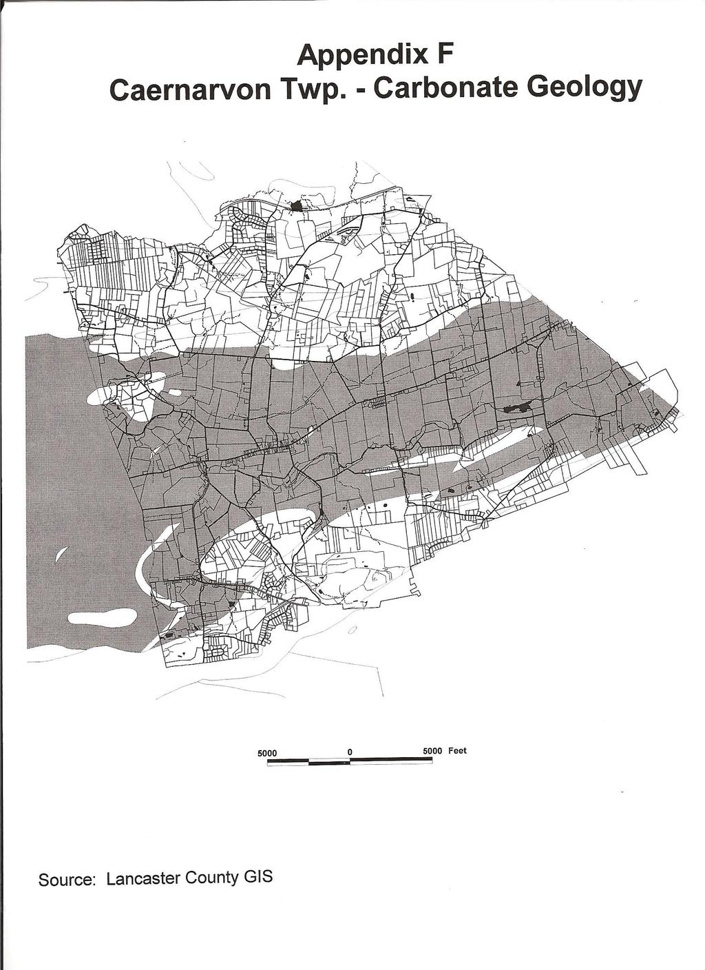
69

70
NORTH CORNWALL TOWNSHIP STORM WATER MANAGEMENT ORDINANCE
 NORTH CORNWALL TOWNSHIP STORM WATER MANAGEMENT ORDINANCE OF 2013 NOVEMBER 20, 2013 Prepared by: TABLE OF CONTENTS ARTICLE I GENERAL PROVISIONS Section 101 Title..... I 1 Section 102 Statement of Findings..
Chapter 149 STORM WATER MANAGEMENT
 Chapter 149 STORM WATER MANAGEMENT ARTICLE I General Provisions 149-1. Title. 149-2. Purpose; implication of provisions. 149-3. Legislative authority. 149-4. Applicability. 149-5. Compliance with other
WATER PART 1 WATER REGULATIONS
 WATER PART 1 WATER REGULATIONS 26-101. Definitions 26-102. Extensions 26-103. Management 26-104. Regulations 26-105. No Connection During Winter Months 26-106. Depth of Pipe 26-107. Removal of Soil 26-108.
West Mead Township STORMWATER MANAGEMENT ORDINANCE
 West Mead Township STORMWATER MANAGEMENT ORDINANCE CRAWFORD COUNTY PENNSYLVANIA STORMWATER MANAGEMENT ORDINANCE FOR WEST MEAD TOWNSHIP CRAWFORD COUNTY PENNSYLVANIA West Mead Township Planning Commission
CLAY TOWNSHIP, LANCASTER COUNTY, PENNSYLVANIA. ORDINANCE No.
 CLAY TOWNSHIP, LANCASTER COUNTY, PENNSYLVANIA ORDINANCE No. AN ORDINANCE OF THE TOWNSHIP OF CLAY, COUNTY OF LANCASTER, COMMONWEALTH OF PENNSYLVANIA, REPEALING CURRENT CHAPTER 11 OF THE CODE OF ORDINANCES
MANOR TOWNSHIP STORM WATER MANAGEMENT ORDINANCE. Adopted May 5, 2014 MANOR TOWNSHIP 950 WEST FAIRWAY DRIVE LANCASTER, PENNSYLVANIA 17603
 MANOR TOWNSHIP STORM WATER MANAGEMENT ORDINANCE Adopted May 5, 2014 MANOR TOWNSHIP 950 WEST FAIRWAY DRIVE LANCASTER, PENNSYLVANIA 17603 (717) 397-4769 Prepared by: RETTEW ASSOCIATES, INC. 3020 COLUMBIA
Swatara Township Lebanon County, Pennsylvania. Subdivision And Land Development Ordinance
 Swatara Township Lebanon County, Pennsylvania Subdivision And Land Development Ordinance ORDINANCE #2013-39 - January 10, 2013 SWATARA TOWNSHIP, LEBANON COUNTY SUBDIVISION AND LAND DEVELOPMENT ORDINANCE
TABLE OF CONTENTS ARTICLE I - GENERAL PROVISIONS
 TABLE OF CONTENTS ARTICLE I - GENERAL PROVISIONS 149-1. Short Title 149-2. Statement of Findings 149-3. Purpose 149-4. Statutory Authority 149-5. Applicability 149-6. Repealer OR Repeals and Continuation
City Of Attleboro Conservation Commission
 City Of Attleboro Conservation Commission GOVERNMENT CENTER, 77 PARK STREET ATTLEBORO, MASSACHUSETTS 02703 (508) 223 2222 FAX 222 3046 GENERAL INSTRUCTIONS AND CHECKLIST FOR COMPLETING STORMWATER MANAGEMENT
Chapter 136. SOIL EROSION
 1 of 8 12/19/2011 4:17 PM Township of Andover, NJ Monday, December 19, 2011 Chapter 136. SOIL EROSION [HISTORY: Adopted by the Township Committee of the Township of Andover by Ord. No. 77-11 (Ch. XVII
(Chapter Flood Damage Prevention)
") Chapter 13.10 Flood Damage Prevention Section: 13.10.010 Purpose and Policy 13.10.020 Definitions 13.10.030 Applicability and Areas of Special Flood Hazard 13.10.040 Administration 13.10.050 Provisions
Chapter 13.10 Flood Damage Prevention Section: 13.10.010 Purpose and Policy 13.10.020 Definitions 13.10.030 Applicability and Areas of Special Flood Hazard 13.10.040 Administration 13.10.050 Provisions
CHARLES CITY COUNTY SITE PLAN ORDINANCE. This Ordinance shall be known as the Charles City County Site Plan Ordinance.
 CHARLES CITY COUNTY SITE PLAN ORDINANCE Section 1. Title This Ordinance shall be known as the Charles City County Site Plan Ordinance. Section 2. Authority. This Ordinance is enacted pursuant to the authority
ARTICLE 5 MINOR SUBDIVISION/LAND DEVELOPMENT
 ARTICLE 5 MINOR SUBDIVISION/LAND DEVELOPMENT SECTION 501 ONLY FINAL PLAN REQUIRED The classification of a proposed subdivision as a "Minor Subdivision" shall only require the submission, review and approval
FINAL SUBDIVISION AND LAND DEVELOPMENT PLAN CHECKLIST. Plan Name. Applicant's Name:
 TOWNSHIP OF UPPER ST. CLAIR FINAL SUBDIVISION AND LAND DEVELOPMENT PLAN CHECKLIST Date Filed Plan Name PLC Applicant's Name: Phone Filing Date for Final Application Final Plat 114.22. FINAL APPLICATION
Chapter 5. Floodplain Management. 5.0 Introduction. 5.1 Floodplain Management and Regulation
 5.0 Introduction This chapter summarizes the Town s rules and regulations regarding floodplain management and development. The requirements presented in this chapter should be used by the design engineer
WEST GOSHEN TOWNSHIP STORMWATER MANAGEMENT ORDINANCE
 WEST GOSHEN TOWNSHIP STORMWATER MANAGEMENT ORDINANCE ORDINANCE NO. OF 2013 West Goshen Township, Chester County, Pennsylvania Adopted at a Public Meeting held on November 13, 2013 TABLE OF CONTENTS PAGE
BACKGROUND There are 23 flood control structures in the Upper Brushy Creek Water Control and Improvement District (District). See attached map.
. See attached map.") BACKGROUND There are 23 flood control structures in the Upper Brushy Creek Water Control and Improvement District (District). See attached map. The U.S Department of Agriculture - Natural Resources Conservation
BACKGROUND There are 23 flood control structures in the Upper Brushy Creek Water Control and Improvement District (District). See attached map. The U.S Department of Agriculture - Natural Resources Conservation
ORDINANCE NO
 26.Sept.2013 ORDINANCE NO. 2013-15 AN ORDINANCE OF THE TOWNSHIP RADNOR, DELAWARE COUNTY, PENNSYLVANIA, ESTABLISHING A USER FEE FOR STORMWATER COLLECTION AND MANAGEMENT WHEREAS, Radnor Township ("Radnor")
E L M E R B O R O U G H L A N D U S E B O A R D APPLICATION COVER SHEET (to be completed for all applications and appeals)
") E L M E R B O R O U G H L A N D U S E B O A R D APPLICATION COVER SHEET (to be completed for all applications and appeals) 1. Name(s): 2. Address: 3. Telephone Number(s): 4. E-mail: 5. Owner Name(s) (if
E L M E R B O R O U G H L A N D U S E B O A R D APPLICATION COVER SHEET (to be completed for all applications and appeals) 1. Name(s): 2. Address: 3. Telephone Number(s): 4. E-mail: 5. Owner Name(s) (if
ARTICLE I. IN GENERAL
 Adopted by City Council on December 7, 2009 AN ORDINANCE TO AMEND AND REORDAIN CHAPTER 10 (WATER PROTECTION) OF THE CODE OF THE CITY OF CHARLOTTESVILLE, 1990, AS AMENDED, BY DELETING SECTIONS 10-51 AND
STORMWATER MANAGEMENT ORDINANCE
 STORMWATER MANAGEMENT ORDINANCE AN AMENDED ORDINANCE REGULATING THE RATE AND VELOCITY OF STORMWATER DISCHARGE FROM PROPOSED DEVELOPMENTS WITHIN THE CITY OF MADISON AND REQUIREMENTS FOR STORMWATER RETENTION
VILLAGE OF ASHVILLE DEPARTMENT OF PUBLIC UTILITIES DIVISION OF STORMWATER MANAGEMENT STORMWATER MANAGEMENT PROGRAM STORMWATER CREDIT MANUAL
 VILLAGE OF ASHVILLE DEPARTMENT OF PUBLIC UTILITIES DIVISION OF STORMWATER MANAGEMENT STORMWATER MANAGEMENT PROGRAM STORMWATER CREDIT MANUAL SECTION I. OVERVIEW AND GENERAL INSTRUCTIONS INTRODUCTION A stormwater
STRASBURG TOWNSHIP LANCASTER COUNTY, PENNSYLVANIA SUBDIVISION AND LAND DEVELOPMENT ORDINANCE
 STRASBURG TOWNSHIP LANCASTER COUNTY, PENNSYLVANIA SUBDIVISION AND LAND DEVELOPMENT ORDINANCE ORDINANCE NO. 97 MARCH 7, 2016 STRASBURG TOWNSHIP 400 BUNKER HILL ROAD STRASBURG, PA 17579 Prepared by: HANOVER
Frequently Asked Questions for: Drainage, Watershed and Water Quality Property Owners Near Creeks Developers and Engineers and Definitions of Terms
 FREQUENTLY ASKED QUESTIONS Draft DEFINITIONS OF TERMS Last Revised July 2, 2008 Introduction: The following questions have been organized in the categories below. We have attempted to group the questions
SITE PLAN REVIEW PROCEDURES SECTION DEVELOPMENTS REQUIRING SITE PLAN APPROVAL
 SECTION 22.01 PURPOSE ARTICLE XXII PROCEDURES The purpose of this Article is to establish uniform requirements of procedure for all developments in the Township. Certain specific types of minor development
Chapter 5. Floodplain Management. 5.0 Introduction. 5.1 Douglas County Comprehensive Master Plan. 5.2 Floodplain Management and Regulation
 5.0 Introduction This chapter summarizes the County s rules and regulations regarding floodplain management and development. The requirements presented in this chapter should be used by the design engineer
***** Subchapter A. GENERAL PROVISIONS ***** PERMIT APPLICATIONS
 105.11. Permit requirements. 105.12. Waiver of permit requirements. Title 25 Environmental Protection Part I. Department of Environmental Protection Subpart C. Protection of Natural Resources Article I.
SIMPLIFIED APPROACH PERMIT PROCEDURES
 SIMPLIFIED APPROACH PERMIT PROCEDURES UPPER ALLEN TOWNSHIP Community Development Department 100 Gettysburg Pike, Mechanicsburg, PA 17055 Phone: 717-766-0756 Fax: 717-796-983 Office Hours: M-F 8:00 AM 4:30
Town of Alexandria. Floodplain Management Ordinance
 1 of 7 8/8/2009 4:56 PM Town of Alexandria Floodplain Management Ordinance SECTION 1 PURPOSE Certain areas of the Town of Alexandria, New Hampshire are subject to periodic flooding, causing serious damages
PRELIMINARY SUBDIVISION AND LAND DEVELOPMENT PLAN CHECKLIST. Applicant's Name:
 TOWNSHIP OF UPPER ST. CLAIR PRELIMINARY SUBDIVISION AND LAND DEVELOPMENT PLAN CHECKLIST Date Filed Plan Name: Applicant's Name: PLC# Phone = OK 0 = Missing; X = Not OK; NA = Not Applicable;? To be Determined;
REGIONAL DISTRICT OF NANAIMO BYLAW NO. 1469
 REGIONAL DISTRICT OF NANAIMO BYLAW NO. 1469 A BYLAW TO ESTABLISH FLOODPLAINS, CONSTRUCTION LEVELS IN FLOODPLAINS, AND SETBACKS FOR LANDFILL AND STRUCTURES IN FLOODPLAINS WHEREAS Section 910 of the Local
CHAPTER 24 F FLOOD ZONE OVERLAY DISTRICT
 CHAPTER 24 OVERLAY DISTRICT SECTION 24.01 PURPOSE It is the intent of this district to apply special regulation to the use of land in those areas subject to periodic inundation. Such regulation is deemed
COMMERCIAL SITE DEVELOPMENT GUIDE FOR UNINCORPORATED ST. CHARLES COUNTY
 COMMERCIAL SITE DEVELOPMENT GUIDE FOR UNINCORPORATED ST. CHARLES COUNTY GENERAL INFORMATION: This brochure is to be used as a guide and is not intended to amend or supersede the corresponding County ordinances
Appendix J: Stormwater Utility Ordinance Guidance
 Appendix J: Stormwater Utility Ordinance Guidance 1. City of Marquette (MI) Stormwater Utility Ordinance 2. Guidance on Establishing Stormwater Utility Fees 169 City of Marquette (MI) Stormwater Utility
YCCD EROSION & SEDIMENT POLLUTION CONTROL (E&SPC) PROGRAM SERVICES FEE SCHEDULE, RULES, & GUIDELINES
 PROGRAM SERVICES FEE SCHEDULE, RULES, & GUIDELINES") YCCD EROSION & SEDIMENT POLLUTION CONTROL (E&SPC) PROGRAM SERVICES FEE SCHEDULE, RULES, & GUIDELINES Adopted by the YCCD Board of Directors on December 14, 2018 Effective January 1, 2019. I. Authority
YCCD EROSION & SEDIMENT POLLUTION CONTROL (E&SPC) PROGRAM SERVICES FEE SCHEDULE, RULES, & GUIDELINES Adopted by the YCCD Board of Directors on December 14, 2018 Effective January 1, 2019. I. Authority
Condominium Unit Requirements.
 ARTICLE 19 CONDOMINIUM REGULATIONS Section 19.01 Purpose. The purpose of this Article is to regulate projects that divide real property under a contractual arrangement known as a condominium. New and conversion
Attached is a Clinton Township Zoning Permit Application and requirements for issuance of a permit.
 To Whom It May Concern: Attached is a Clinton Township Zoning Permit Application and requirements for issuance of a permit. The fee for the permit application is $75.00, which shall be made payable to
CHAPTER 15 SOIL DRAINAGE MANAGEMENT PLAN DESIGN STATE HEALTH DEPARTMENT SEWAGE HANDLING AND DISPOSAL REGULATIONS. Article 5
 CHAPTER 15 SOIL DRAINAGE MANAGEMENT PLAN DESIGN STATE HEALTH DEPARTMENT SEWAGE HANDLING AND DISPOSAL REGULATIONS Article 5 Installation of Residential Sewage Disposal Systems in Political Subdivisions
ARTICLE 4 MAJOR SUBDIVISION/LAND DEVELOPMENT PLAN REQUIREMENTS
 ARTICLE 4 MAJOR SUBDIVISION/LAND DEVELOPMENT PLAN REQUIREMENTS SECTION 401 LAND SKETCH PLANS FOR MAJOR SUBDIVISIONS AND DEVELOPMENTS 401.1 Sketch Plan Information The following process and procedures shall
SECTION 4: PRELIMINARY PLAT
 SECTION 4: PRELIMINARY PLAT After the completion of the sketch plan process, if submitted, the owner or developer shall file with the City an application for preliminary plat. The preliminary plat stage
STORMWATER MANAGEMENT AGREEMENT AND DECLARATION OF EASEMENT
 APPENDIX F STORMWATER MANAGEMENT AGREEMENT AND DECLARATION OF EASEMENT THIS AGREEMENT AND DECLARATION OF EASEMENT made this day of 20, by and between BRECKNOCK TOWNSHIP, Lancaster County, Pennsylvania,
-MENDOCINO COUNTY PLANNING AND BUILDING SERVICES- DIVISION OF LAND REGULATIONS TITLE 17
 ARTICLE VI -- GENERAL REGULATIONS AND PROVISIONS Sec. 17-50. Sec. 17-51 General Plan. Sec. 17-52 Lot and Block Design and Configuration. Sec. 17-53 Lot Access. Sec. 17-54 Private Roads. Sec. 17-55 Water
CHAPTER 15 SOIL DRAINAGE MANAGEMENT PLAN DESIGN STATE HEALTH DEPARTMENT SEWAGE HANDLING AND DISPOSAL REGULATIONS. Article 5
 CHAPTER 15 SOIL DRAINAGE MANAGEMENT PLAN DESIGN STATE HEALTH DEPARTMENT SEWAGE HANDLING AND DISPOSAL REGULATIONS Article 5 Installation of Residential Sewage Disposal Systems in Political Subdivisions
Waseca County Planning and Zoning Office
 Waseca County Planning and Zoning Office 300 North State Street Waseca, Minnesota 56093 Phone: 507-835-0650 Fax: 507-837-5310 Form no. PZ 081009 Web Site: www.co.waseca.mn.us FEES: 1) CUP FEE- $400.00
610 LAND DIVISIONS AND PROPERTY LINE ADJUSTMENTS OUTSIDE A UGB
 ARTICLE VI: LAND DIVISIONS AND PROPERTY LINE ADJUSTMENTS VI-21 610 LAND DIVISIONS AND PROPERTY LINE ADJUSTMENTS OUTSIDE A UGB 610-1 Property Line Adjustments (Property Line Relocation) A property line
Open Space Model Ordinance
 Open Space Model Ordinance Section I. Background Open space development has numerous environmental and community benefits, including: 1) Reduces the impervious cover in a development. Impervious cover
ARTICLE 13 CONDOMINIUM REGULATIONS
 ARTICLE 13 CONDOMINIUM REGULATIONS Section 13.01 Purpose. The purpose of this Article is to regulate projects that divide real property under a contractual arrangement known as a condominium. New and conversion
New Private Way Ordinance Westbrook Planning Board Workshop , Planning Board Public Hearing Definitions
 201 Definitions Private Right of Way; Private way A strip of land at least fifty feet wide, meeting the minimum standards for the construction of a gravel base for a public road, over which abutters may
ARTICLE 7 UTILITIES AND EASEMENTS
 7.1 PLACEMENT OF UTILITIES ARTICLE 7 UTILITIES AND EASEMENTS 7.1.1 All authorized public underground utilities shall be located within the right-of-way of a public street or within an easement designated
Appendix A. Definitions
 Definitions 1. Terms Defined. Words contained in this are those having a special meaning relative to the purposes of this Ordinance. Words not listed in this section shall be defined by reference to: (1)
SPANISH FORT PLANNING COMMISSION PRELIMINARY SUBDIVISION PLAT APPLICATION. Number of Lots (Units) Address. Address.
 Address. Address.") Case No. SPANISH FORT PLANNING COMMISSION PRELIMINARY SUBDIVISION PLAT APPLICATION Name of Subdivision Tax Parcel Number(s) Subdivision Location Total Acreage Number of Lots (Units) Average Lot Size Current
Case No. SPANISH FORT PLANNING COMMISSION PRELIMINARY SUBDIVISION PLAT APPLICATION Name of Subdivision Tax Parcel Number(s) Subdivision Location Total Acreage Number of Lots (Units) Average Lot Size Current
SECTION 10: FLOOD HAZARD EVALUATION 10-1
 10) SECTION 10: FLOOD HAZARD EVALUATION A. General. Land subject to being flooded by a Flood of 100-Year Frequency as defined by Title 76, Chapter 5, MCA, or land subject to flooding pursuant to these
(b) The location of principal and accessory buildings on the lot and the relationship of each structure to the other.
 The location of principal and accessory buildings on the lot and the relationship of each structure to the other.") ARTICLE XIX SITE PLAN Sec. 20-1900 Site Plan Review Procedure - Intent The site plan review procedures are instituted to provide an opportunity for the Township Planning Commission to review the proposed
ARTICLE XIX SITE PLAN Sec. 20-1900 Site Plan Review Procedure - Intent The site plan review procedures are instituted to provide an opportunity for the Township Planning Commission to review the proposed
CONSTRUCTION SITE EROSION CONTROL & STORMWATER MANAGEMENT JULY 3, 2014
 CHAPTER 9 Construction Site Erosion Control and Stormwater Management 10-9-1 Authority 10-9-2 Findings and Purpose 10-9-3 Applicability and Jurisdiction (1) Applicability (2) Jurisdiction (3) Exclusions
Village of Sussex Chapter 14 Page 1 of 67 11/22/2016 Ord. 827
 STORMWATER UTILITY 14.01 Findings and Determination 14.02 Creation 14.03 Management 14.04 Applications 14.05 Definitions refer to 14.800 14.06 Establishment 14.07 Stormwater Utility Fee 14.08 Stormwater
Article III. Erosion and Sedimentation Control
 Article III. Erosion and Sedimentation Control Section 9.6 Erosion and Sedimentation Control Plan Requirements Section 9.6.1 Plan Submission A plan shall be prepared for all land-disturbing activities
CHECKLIST FOR DEVELOPMENT REVIEW
 CHECKLIST FOR DEVELOPMENT REVIEW Petitions and related documents and plans for land development or other proposals regulated by Title 16 of the Municipal Code (Development Ordinance) and Title 17 of the
APPLICATION PROCEDURE
 ANTRIM PLANNING BOARD P. O. Box 517 Antrim, New Hampshire 03440 Phone: 603-588-6785 FAX: 603-588-2969 APPLICATION FORM AND CHECKLIST FOR MINOR OR MAJOR SITE PLAN REVIEW File Date Received By APPLICATION
BRISTOL CONSERVATION COMMISSION INLAND WETLANDS AGENCY FORM IW-1 (Application for a Wetlands Permit)
") APPLICATION NO. BRISTOL CONSERVATION COMMISSION INLAND WETLANDS AGENCY FORM IW-1 (Application for a Wetlands Permit) DATE FILED: APPROVED: DENIED: 1. APPLICANT: Name: Signature: Address: City: State: Zip
APPLICATION NO. BRISTOL CONSERVATION COMMISSION INLAND WETLANDS AGENCY FORM IW-1 (Application for a Wetlands Permit) DATE FILED: APPROVED: DENIED: 1. APPLICANT: Name: Signature: Address: City: State: Zip
LINCOLN COUNTY FLOOD DAMAGE PREVENTION ORDINANCE
 LINCOLN COUNTY FLOOD DAMAGE PREVENTION ORDINANCE SECTION 1.0 STATUTORY AUTHORIZATION, FINDINGS OF FACT, PURPOSE AND OBJECTIVES SECTION 2 DEFINITIONS SECTION 3.0 GENERAL PROVISIONS SECTION 4.0 ADMINISTRATION
SPRING BROOK TOWNSHIP 966 STATE ROUTE 307 SPRING BROOK TOWNSHIP, PA PHONE (570) FAX (570)
 FAX (570)") PERMIT # - D SPRING BROOK TOWNSHIP 966 STATE ROUTE 307 SPRING BROOK TOWNSHIP, PA 18444 PHONE (570) 842-7028 FAX (570) 842-0633 Date: PART I APPLICATION DRIVEWAY INSTALLATION APPLICATION AND PERMIT Name:
PERMIT # - D SPRING BROOK TOWNSHIP 966 STATE ROUTE 307 SPRING BROOK TOWNSHIP, PA 18444 PHONE (570) 842-7028 FAX (570) 842-0633 Date: PART I APPLICATION DRIVEWAY INSTALLATION APPLICATION AND PERMIT Name:
STORMWATER MANAGEMENT DESIGN ASSISTANCE MANUAL
 STORMWATER MANAGEMENT DESIGN ASSISTANCE MANUAL For Regulated Activities in Salisbury Township Lancaster County, Pennsylvania SIMPLIFIED APPROACH TABLE OF CONTENTS Contents Introduction...3 Importance of
Moore Township Planning Commission 2491 Community Drive, Bath, Pennsylvania Telephone: FAX: Rev:12/23/2013
 2491 Community Drive, Bath, Pennsylvania Telephone: 610-759-9449 FAX: 610-759-9448 Rev:12/23/2013 APPLICATION FORM FOR A SITE PLAN PER MOORE TOWNSHIP ZONING ORDINANCE SECTION 200-58.1 NORTHAMPTON COUNTY,
géãç Éy VtÇtÇwt zât 5440 Routes 5 & 20 West Canandaigua, NY Phone: (585) / Fax: (585)
 / Fax: (585)") géãç Éy VtÇtÇwt zât 5440 Routes 5 & 20 West Canandaigua, NY 14424 Phone: (585) 394-1120 / Fax: (585) 394-9476 NOTICE TO ALL PLANNING BOARD APPLICANTS FOR PRELIMINARY SUBDIVISION PHASED PROJECTS The applicant
géãç Éy VtÇtÇwt zât 5440 Routes 5 & 20 West Canandaigua, NY 14424 Phone: (585) 394-1120 / Fax: (585) 394-9476 NOTICE TO ALL PLANNING BOARD APPLICANTS FOR PRELIMINARY SUBDIVISION PHASED PROJECTS The applicant
ORDINANCE 90-2 Solid Waste Facility Siting Ordinance of Wythe County, Virginia. ARTICLE I - Title, Authority, and Jurisdiction
 ORDINANCE 90-2 Solid Waste Facility Siting Ordinance of Wythe County, Virginia ARTICLE I - Title, Authority, and Jurisdiction 1.1 Title. This ordinance shall be known as the "Solid Waste Facility Siting
CONDOMINIUM REGULATIONS
 ARTICLE 37 CONDOMINIUM REGULATIONS SECTION 37.01. Purpose The purpose of this Article is to regulate projects that divide real property under a contractual arrangement known as a condominium. New and conversion
SUBDIVISION AND LAND DEVELOPMENT. 185 Attachment 20
 185 Attachment 20 APPENDIX S Plat No. Date of Submission Twp. Fee $ Dauphin Co. Fee $ TOWNSHIP OF DERRY SUBDIVISION OR LAND DEVELOPMENT PLAN SUBMISSION APPLICATION This block for Twp. use only 1. Title
Clarksville, TN APPENDIX C STORM WATER AND BMP MAINTENANCE AGREEMENTS AND INSPECTIONS FORMS
 Clarksville, TN APPENDIX C STORM WATER AND BMP MAINTENANCE AGREEMENTS AND INSPECTIONS FORMS STORM WATER MAINTENANCE AGREEMENT Grading Permit No.: Tax Map and Parcel No.: Project Name: THIS AGREEMENT, made
UPPER MOUNT BETHEL TOWNSHIP NORTHAMPTON COUNTY, PENNSYLVANIA
 UPPER MOUNT BETHEL TOWNSHIP NORTHAMPTON COUNTY, PENNSYLVANIA JOINDER DEED / LOT CONSOLIDATION TOWNSHIP REVIEW PROCESS When accepting proposed Joinder Deeds / Lot Consolidations, review the Joinder Deed
MAJOR SUBDIVISION PRELIMINARY PLAT CHECKLIST
 TOWNSHIP OF EGG HARBOR PLANNING BOARD/ZONING BOARD OF ADJUSTMENT 3515 BARGAINTOWN ROAD EGG HARBOR TOWNSHIP, NJ 08234 MAJOR SUBDIVISION PRELIMINARY PLAT CHECKLIST The following checklist is designed to
ANDOVER CODE. Checklist #5 Preliminary Site Plan Conditional Use
 ANDOVER CODE Checklist #5 Preliminary Site Plan Conditional Use Applicant: Block Lot File No. This checklist is for general reference only. Further information may be required by the reviewing authority.
ARTICLE V PRELIMINARY PLAN SUBMISSION
 ARTICLE V PRELIMINARY PLAN SUBMISSION 501. Plan Requirements a. On or before the 25 th day of the month prior to a regularly scheduled meeting of the Planning Commission, the applicant shall submit two
FREQUENTLY USED PLANNING & ZONING TERMS
 City Of Mustang FREQUENTLY USED PLANNING & ZONING TERMS Abut: Having property lines, street lines, or zoning district lines in common. Accessory Structure: A structure of secondary importance or function
STORMWATER BEST MANAGEMENT PRACTICES OPERATIONS AND MAINTENANCE AGREEMENT
 STORMWATER BEST MANAGEMENT PRACTICES OPERATIONS AND MAINTENANCE AGREEMENT THIS AGREEMENT, made and entered into this day of, 20, by and between, (hereinafter the Landowner ), and the TOWNSHIP OF HEMPFIELD,
ARTICLE 16. FLOODPLAIN MANAGEMENT, EROSION AND SEDIMENT CONTROL, AND STORMWATER MANAGEMENT
 ARTICLE 16. FLOODPLAIN MANAGEMENT, EROSION AND SEDIMENT CONTROL, AND STORMWATER MANAGEMENT Title 1. DEFINITIONS AND GENERAL PROVISIONS 2. FLOODPLAIN MANAGEMENT 3. EROSION AND SEDIMENT CONTROL 4. STORMWATER
CHAPTER XVIII SITE PLAN REVIEW
 CHAPTER XVIII SITE PLAN REVIEW Section 18.1 Section 18.2 Description and Purpose. The purpose of this chapter is to provide standards and procedures under which applicants would submit, and the Township
COMMONWEALTH OF PENNSYLVANIA DEPARTMENT OF ENVIRONMENTAL PROTECTION BUREAU OF CLEAN WATER
 3800-FM-BCW0229b 7/2017 COMMONWEALTH OF PENNSYLVANIA DEPARTMENT OF ENVIRONMENTAL PROTECTION BUREAU OF CLEAN WATER OFFICIAL USE ONLY PA NOTICE OF TERMINATION FOR A GENERAL (PAG-02) OR INDIVIDUAL NPDES PERMIT,
Special Use Permit - Planned Unit Development Checklist. Property Address:
 Special Use Permit - Planned Unit Development Checklist Special Use Permit Number. Parcel Code/s #28-11- - - Property Address: Applicant: ARTICLE VIII Ordinance Reference - Section 8.1.2 Permit Procedures:
Appendix A Orleans County Local Law Assessment
 Appendix A Orleans County Local Law Assessment Appendix A 0 Albion, Town Does the municipality have: Comprehensive/ Master Local Law Assessment es o Reference: Comments: Town of Albion, Village of Albion,
Extractive Industrial Regulatory Ordinance No. 21 revised Dec. 28, 2010 EXTRACTIVE INDUSTRIAL REGULATORY ORDINANCE TYRONE TOWNSHIP, MICHIGAN
 40.101 Sec. 1. TITLE. EXTRACTIVE INDUSTRIAL REGULATORY ORDINANCE TYRONE TOWNSHIP, MICHIGAN ord. no. 21 eff. May 12, 1979, revised Dec. 28, 2010 This ordinance shall be known and cited as the Tyrone Township
THE COUNTY BOARD OF SUPERVISORS OF THE COUNTY OF DOUGLAS DOES ORDAIN AS FOLLOWS:
 8.1 SUBDIVISION CONTROL ORDINANCE THE COUNTY BOARD OF SUPERVISORS OF THE COUNTY OF DOUGLAS DOES ORDAIN AS FOLLOWS: SECTION I. GENERAL INTERPRETATION This ordinance shall not repeal, impair or modify private
STORMWATER MANAGEMENT SYSTEM AND FACILITIES
 152.01 Purpose 152.09 Nonresidential Unit 152.02 Findings 152.10 Rate Determinations; Compliance with Bond 152.03 Scope and Responsibility for Stormwater Utility Covenants 152.04 Definitions 152.11 Billing,
PART 2 DEFINITIONS. Unless otherwise expressly stated, the following terms shall, for the purpose of this Ordinance, have the meaning indicated below.
 PART 2 DEFINITIONS SECTION 201 GENERAL Unless otherwise expressly stated, the following terms shall, for the purpose of this Ordinance, have the meaning indicated below. SECTION 202 GENERAL TERMS The definitions
TOWNSHIP OF EGG HARBOR ZONING BOARD ADJUSTMENT CHECK LIST
 TOWNSHIP OF EGG HARBOR ZONING BOARD ADJUSTMENT CHECK LIST Schedule A - General Requirements 1. Where the application involves only a variance one (1) original and nineteen (19) copies of the appropriate
HAMILTON TOWNSHIP SUBDIVISION AND LAND DEVELOPMENT ORDINANCE
 HAMILTON TOWNSHIP SUBDIVISION AND LAND DEVELOPMENT ORDINANCE HAMILTON TOWNSHIP SUPERVISORS 1270 CROTTLESTOWN ROAD CHAMBERSBURG, PENNSYLVANIA 1720 1 (7 17) 264-2946 AS PROPOSED FEBRUARY 6,2002 HAMILTON
City of Duluth Development Regulations
 ARTICLE 10 PLAN AND PLAT SPECIFICATIONS 10.1 CONCEPT PLAN SPECIFICATIONS The following paragraphs outline the required elements of both the required and optional plans and plats mentioned throughout these
SUBDIVISION APPLICATION CHECKLIST SKETCH PLAN PRELIMINARY PLAT FINAL PLAT
 RECEIVED STAMP SUBDIVISION APPLICATION CHECKLIST SKETCH PLAN PRELIMINARY PLAT FINAL PLAT A checklist of background information and submission requirements for processing of a sketch plan, preliminary plat
ARTICLE 15 - PLANNED UNIT DEVELOPMENT
 Section 15.1 - Intent. ARTICLE 15 - PLANNED UNIT DEVELOPMENT A PUD, or Planned Unit Development, is not a District per se, but rather a set of standards that may be applied to a development type. The Planned
TOWN OF WATERVILLE VALLEY NEW HAMPSHIRE SITE PLAN REVIEW REGULATIONS
 TOWN OF WATERVILLE VALLEY NEW HAMPSHIRE Effective date March 17, 1981 Revised March 16, 1982 Revised March 13, 1986 Revised March 10, 1987 Revised March 14, 2013 Revised March 8, 2016 TOWN OF WATERVILLE
STORMWATER BEST MANAGEMENT PRACTICES OPERATION, MAINTENANCE, AND INSPECTION PLAN AND AGREEMENT
 STORMWATER BEST MANAGEMENT PRACTICES OPERATION, MAINTENANCE, AND INSPECTION PLAN AND AGREEMENT THIS AGREEMENT, made and entered into this day of, 20, by and between Township, Chester County, Pennsylvania,
ARTICLE 6 PRELIMINARY PLAT
 ARTICLE 6 PRELIMINARY PLAT SECTION: 30-06-01: Preliminary Plat 30-06-02: Information Required for Preliminary Plat 30-06-03: Determination of Requirement for Environmental Review Documents 30-06-04: Additional
13-2 SUBDIVISION PLANS AND PLATS REQUIRED EXCEPTIONS Subdivision Plats Required To be Recorded
 ARTICLE XIII SUBDIVISIONS 13-1 INTENT AND PURPOSE 13-1-1 Intent: It is the intent of the County Commission through the adoption of this Article to more fully avail itself of the power granted under 17-27-601
CHAPTER 5 RULES, RATES AND CHARGES FOR THE STORMWATER UTILITY SERVICE 1
 Change 8, April 1, 2008 19-47 CHAPTER 5 RULES, RATES AND CHARGES FOR THE STORMWATER UTILITY SERVICE 1 SECTION 19-501. Rules, rates, and charges adopted. 19-502. Findings. 19-503. Definitions. 19-504. Determination
ARTICLE 7: PLOT PLANS AND SITE PLAN REQUIREMENTS AND REVIEW
 ARTICLE 7: PLOT PLANS AND SITE PLAN REQUIREMENTS AND REVIEW Section 7.0 - Purpose The purpose of this article is to specify the documents and/or drawings required for a Site Plan Review or a Plot Plan
(Ord. No. 743, )
") CHAPTER 330. - FLOODPLAIN MANAGEMENT Section 330-1. - Purpose. (a) (b) (c) (d) It is hereby determined that the flood hazard areas of the City of Chamblee are subject to periodic inundation which may result
CHAPTER 330. - FLOODPLAIN MANAGEMENT Section 330-1. - Purpose. (a) (b) (c) (d) It is hereby determined that the flood hazard areas of the City of Chamblee are subject to periodic inundation which may result
WEST CALN TOWNSHIP CHESTER COUNTY
 WEST CALN TOWNSHIP CHESTER COUNTY SUBDIVISION AND LAND DEVELOPMENT ORDINANCE Developed and submitted to West Caln Township by: Brandywine Conservancy and E.B. Walsh and Associates, Inc. With direct support
Change 6, September 1, TITLE 18 WATER AND SEWERS 1
 Change 6, September 1, 2011 18-1 TITLE 18 WATER AND SEWERS 1 CHAPTER 1. MISCELLANEOUS. 2. CITY WASTEWATER SYSTEM. 3. WASTEWATER TREATMENT (SEWER) SYSTEM. 4. WATER. 5. CONNECTIONS WITH PUBLIC WATER SUPPLY.
CHAPTER 3 PRELIMINARY PLAT
 10-3-1 10-3-3 SECTION: CHAPTER 3 PRELIMINARY PLAT 10-3-1: Consultation 10-3-2: Filing 10-3-3: Requirements 10-3-4: Approval 10-3-5: Time Limitation 10-3-6: Grading Limitation 10-3-1: CONSULTATION: Each
WEST VINCENT TOWNSHIP SUBDIVISION AND LAND DEVELOPMENT ORDINANCE OF 1998
 WEST VINCENT TOWNSHIP SUBDIVISION AND LAND DEVELOPMENT ORDINANCE OF 1998 As amended by Ordinance No. 102-1999 As amended by Ordinance No. 112-2001 As amended by Ordinance No. 117-2002 As amended by Ordinance
RULES AND REGULATIONS FOR ADMINISTRATION OF AREA DRAINAGE PLANS
 RIVERSIDE COUNTY RULES AND REGULATIONS FOR ADMINISTRATION OF AREA DRAINAGE PLANS ADOPTED JUNE 10, 1980 BY RESOLUTION NO. 80-244 AMENDMENTS RESOLUTION NO. May 26, 1981 81-148 Nov. 9, 1982 82-320 July 3,