CITY COMMISSION MEETING AGENDA City Hall Commission Chambers Tuesday, January 17, :00 p.m. MEETING #5056
|
|
|
- Dulcie Wade
- 5 years ago
- Views:
Transcription
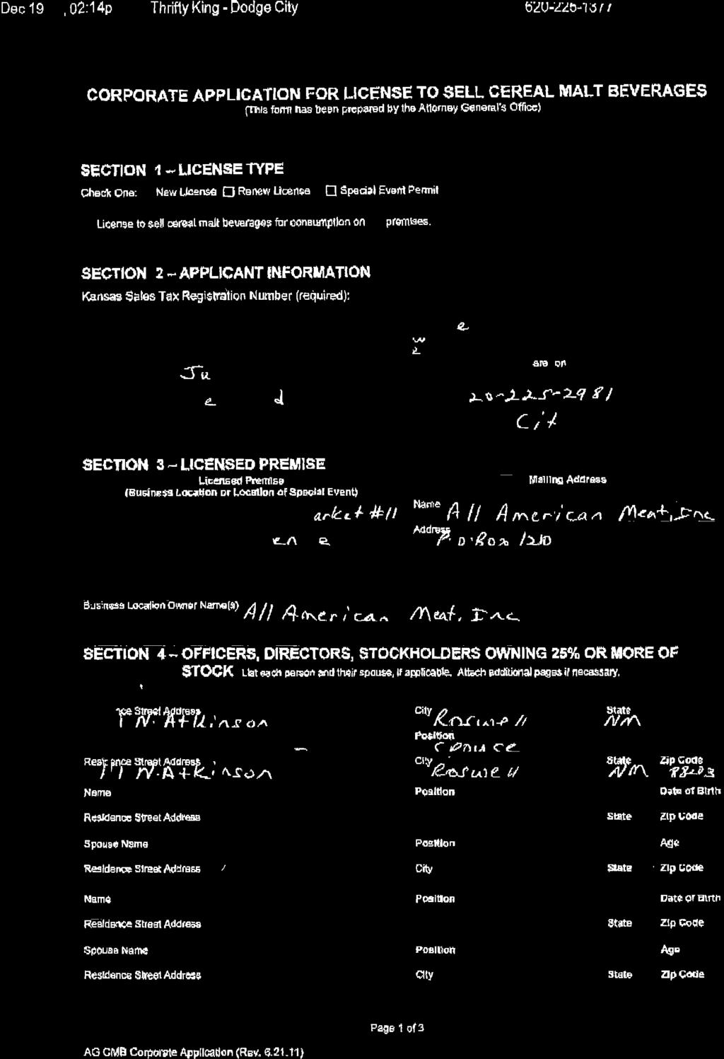
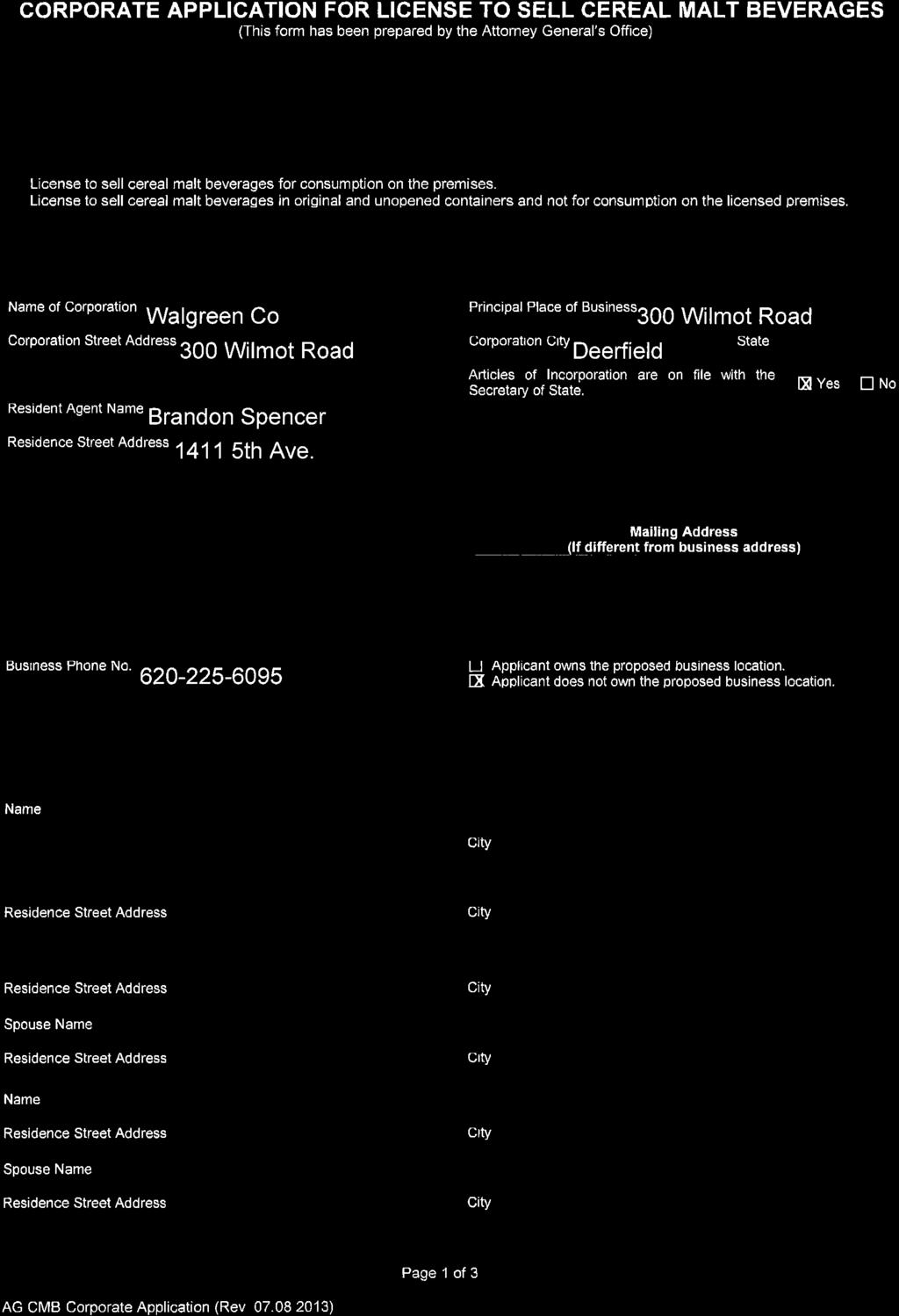
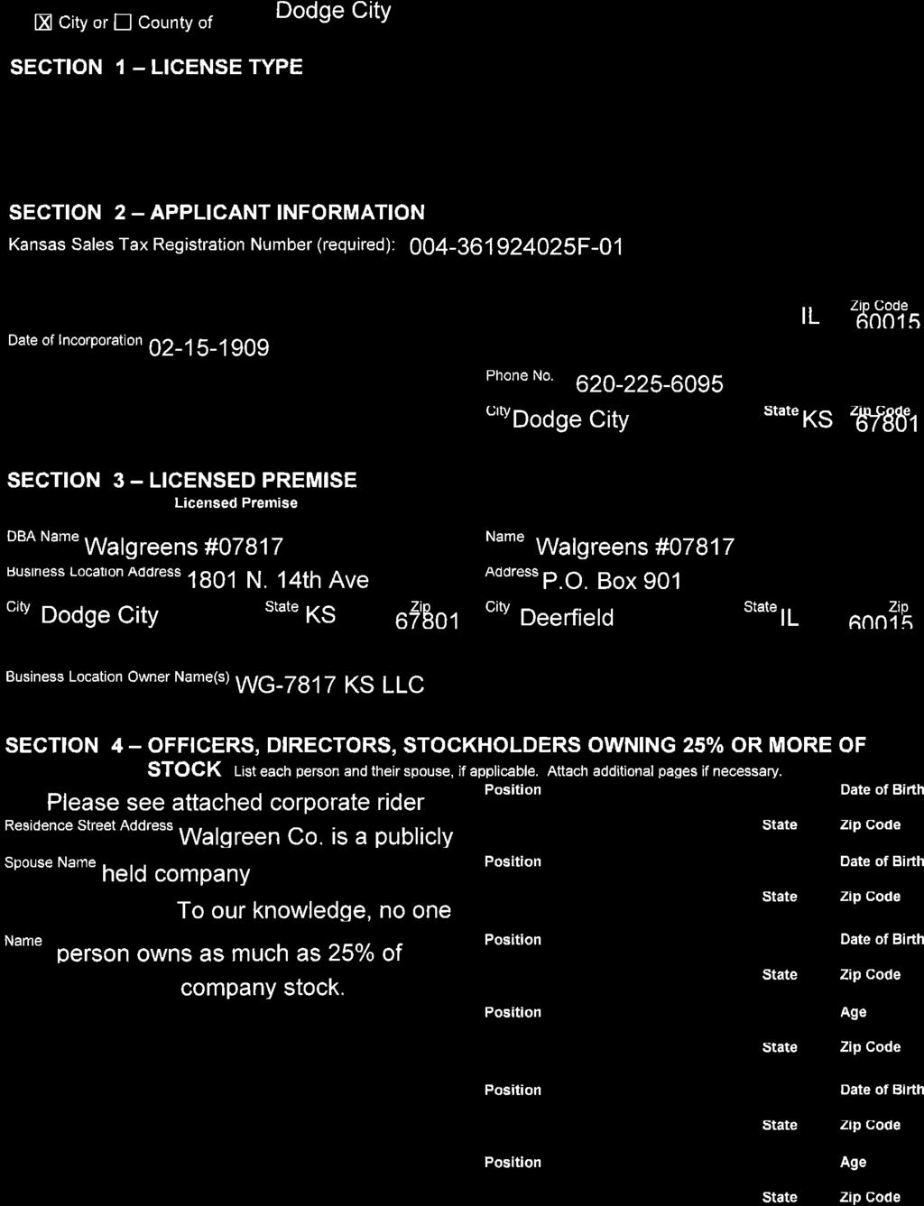
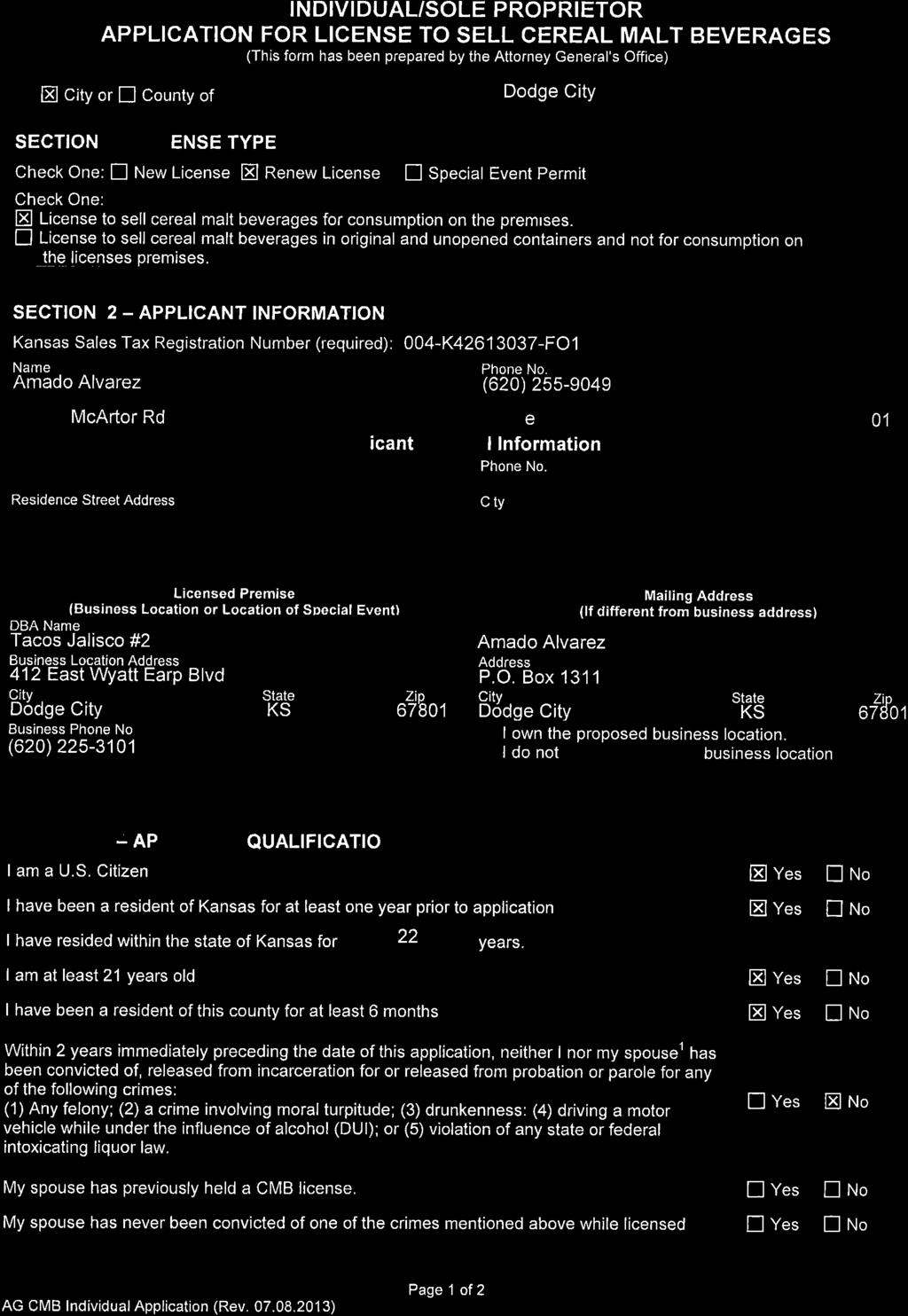
1 CALL TO ORDER ROLL CALL CITY COMMISSION MEETING AGENDA City Hall Commission Chambers Tuesday, January 17, :00 p.m. MEETING #5056 INVOCATION by Chaplain Shannon Sanchez of Fort Dodge Chapel PLEDGE OF ALLEGIANCE PETITIONS & PROCLAMATIONS VISITORS (Limit of five minutes per individual and fifteen minutes per topic. Final action may be deferred until the next City Commission meeting unless an emergency situation does exist). Public Library Quarterly Report CONSENT CALENDAR 1. Approval of City Commission Meeting Minutes, January 3; Appropriation Ordinance No.2, January 17, 2017; 3. Cereal Malt Beverage License: a. Walgreens Store, 1800 N. 14 th Avenue, b. Tacos Jalisco, 412 E. Wyatt Earp Blvd., c. Taylor s Roadhouse, 2305 W. Wyatt Earp Blvd., 4. Approval of Lease Agreement for Dodge City Area Chamber of Commerce and Dodge City/Ford County Development Corporation at Depot Building; 5. Approval of Lease Agreement with SER at Hennessey Hall. ORDINANCES & RESOLUTIONS Resolution No : A Resolution of the Governing Body of the City of Dodge City Authorizing an Agreement to Cooperate with Other Municipalities to form a group-funded pool entitled bylaws and Interlocal Cooperation Agreement for the Kansas Municipal Insurance Trust. Report by Director of Administration, Ryan Reid.
2 Resolution No : A Resolution Approving the ByLaws and Interlocal Cooperation Agreement for Midwest Public Risk Kansas. Report by Director of Administration, Ryan Reid. Resolution No : A Resolution Approving the Sister City Agreement between the City of Dodge City, Kansas and the Town of Beit Jann, Israel. Report by Assistant to City Manager/Assistant to Finance Director, Ernestor DelaRosa. UNFINISHED BUSINESS NEW BUSINESS 1. Approval of 2017 Street Program. Report by Director of Engineering, Ray Slattery. 2. Approval of Final Platt for Candletree #8. Report by Planning, Zoning, Storm Water Coordinator, Nathan Littrell. OTHER BUSINESS ADJOURNMENT
3 CITY COMMISSION MEETING MINUTES City Hall Commission Chambers Tuesday, January 3, :00 p.m. MEETING #5055 CALL TO ORDER ROLL CALL: Mayor Rick Sowers, Commissioners Jan Scoggins and Brian Delzeit. Commissioners Kent Smoll and Joyce Warshaw were reported absent. INVOCATION by Chaplain Shannon Sanchez of Fort Dodge Chapel PLEDGE OF ALLEGIANCE VISITORS (Limit of five minutes per individual and fifteen minutes per topic. Final action may be deferred until the next City Commission meeting unless an emergency situation does exist). CONSENT CALENDAR 1. Approval of City Commission Meeting Minutes, December 19, 2016; 2. Approval of City Commission Meeting Minutes, December 29, 2016; 3. Appropriation Ordinance No. 25, December 30, 2016; 4. Appropriation Ordinance No.1, January 3, 2017; 5. Cereal Malt Beverage License: a. Farmers Country Market, 1800 Central Avenue. Commissioner Brian Delzeit moved to approve the Consent Calendar as presented. Commissioner Jan Scoggins seconded the motion. The motion carried 3-0. ORDINANCES & RESOLUTIONS NEW BUSINESS Commissioner Brian Delzeit moved to give authorization to the City Manager to approve cost proposals not to exceed $40,000 for the Santa Fe Depot upper floor development. The motion was seconded by Commissioner Jan Scoggins. The motion carried 3-0. OTHER BUSINESS City Manager, Cherise Tieben - Reminder, there will be a public hearing at 5:00 p.m. on Thursday, January 5 in the City Commission Chambers for the STAR Bond District on 14 th Avenue; - Danny Gillum s reception will be held on January 6 at the Ford County Government Center;
4 Page 2 City Commission Meeting Minutes January 3, The next City Commission meeting will be Tuesday, January 17, 2017; - Sandie Masden s retirement reception will be held on January 20, 2017 in the Military Plaza. Commissioner, Jan Scoggins - Thanked the United Wireless Arena for opening the Ice Skating during the week between Christmas and New Year s. It was well attended; - Thanked the Park Department for the outstanding job on the Mayor s Christmas Tree; - The exercise equipment outside west of the Sheridan Activity Center is well used; - The YMCA has had a lot of activity; - Hope 2017 treats you right. Commissioner, Brian Delzeit - Happy New Year! Mayor, Rick Sowers ADJOURNMENT Commissioner Jan Scoggins moved to adjourn the meeting. Commissioner Brian Delzeit seconded the motion. The motion carried 3-0. ATTEST: Mayor Nannette Pogue, City Clerk
5
6
7
8
9
10
11
12
13
14
15

16
17

18
19
20
21
22
23

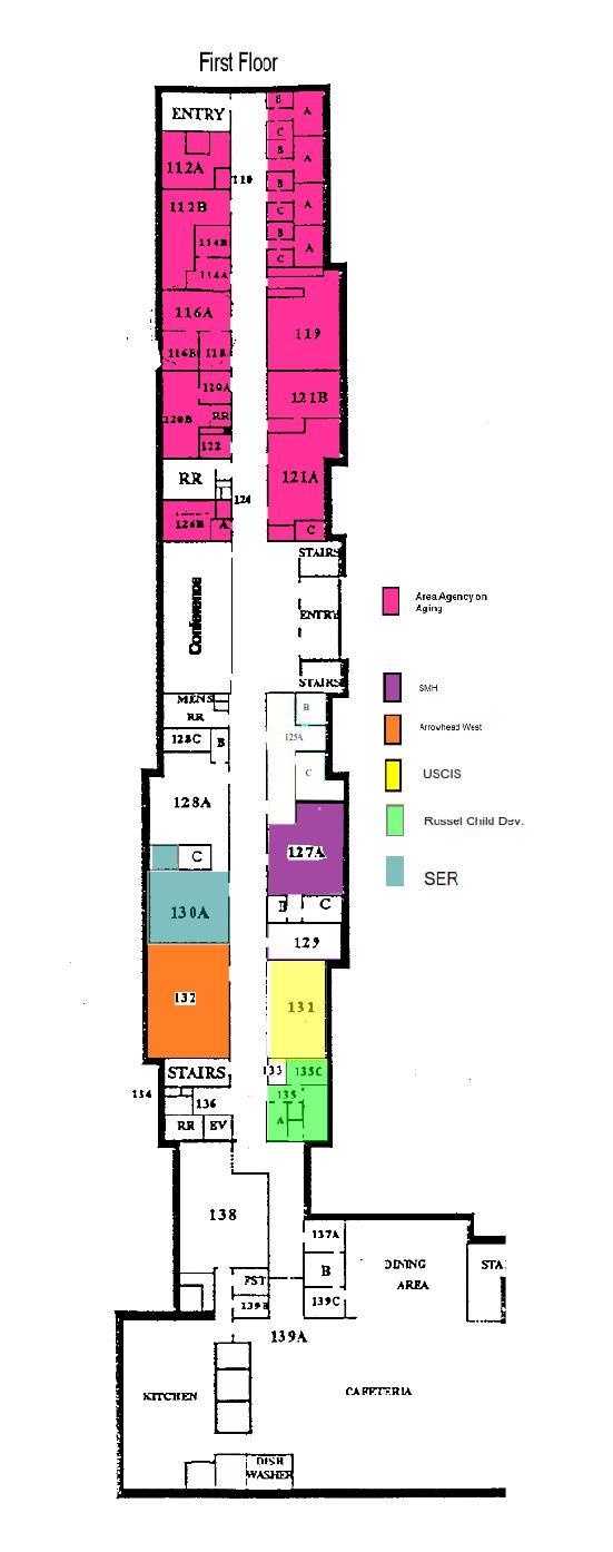
24 Parks and Recreation PO Box 880 Dodge City KS Phone: 620/ Fax: 620/ Memorandum To: Cherise Tieben, City Manager City Commissioners From: Paul Lewis, Parks & Recreation Director Date: January 11, 2017 Subject: Hennessy Lease Agreement Agenda Item: Consent Calendar RECOMMENDATION: Staff recommends approving the lease with SER Jobs for National Progress Inc. for space at Hennessy Hall. BACKGROUND: SER desires to lease space at Hennessy to house their operations and services. The space being leased is on the first floor, room 130. The total space being leased is 700 square feet and is a new three year lease. SER is a national network of employment and training organizations that formulates and advocates initiatives focusing on the needs of Hispanics in the areas of education, training, employment, business and economic opportunity. JUSTIFICATION: SER is a not-for-profit public service enterprise that is compatible with other entities currently housed in the facility. FINANCIAL CONSIDERATIONS: The annual lease payment will be $4,200 based on the standard $6 per sq. ft. base rent. Lease payments are prorated monthly and billed through City Hall. SER also requested removal of a concrete teacher s platform that was in the space and we installed new carpet. In exchange for those considerations, SER will pay an additional $1,000 up front to help compensate for those expenses. Because SER s operations are dependent on grant funding, this lease allows termination of the agreement should those funding sources no longer exist. Under those circumstances, SER agrees to not lease any other space in Ford County during the term of the agreement. PURPOSE/MISSION: This lease agreement is consistent with the City s core purpose of Ongoing Improvement as it facilitates additional opportunities in the community to provide training and resources that serve the education and development of children in the community. LEGAL CONSIDERATIONS: The agreement is the standard form used with all Hennessy tenants. ATTACHMENTS: Lease Agreement Exhibit A Floor Plan
25 Hennessey Hall Lease Agreement This lease agreement is made and entered into by and between the City of Dodge City, Kansas, a municipal corporation (LANDORD) and SER-Jobs for Progress National, Inc., a Kansas not-forprofit corporation. (TENANT). In consideration of the mutual promises and covenants of the parties as set forth herein, the LANDLORD and TENANT agree as follows: 1. LEASE PREMISES: The LANDLORD hereby leases to TENANT part of that property knows as Hennessey Hall, located on the former St. Mary s of the Plains College Campus in Dodge City, Kansas. Attached hereto as Exhibit A are the specifications of Hennessey Hall. That portion of the premises hereby leased to TENANT is outlined in red, comprising approximately seven hundred square feet (700) and labeled as Room 130. The outlined portion of Exhibit A, attached hereto and made a part hereof, is hereinafter collectively referred to as the leased premises. 2. TERM: The term of this lease shall be for a period of three (3) years commencing February 1, 2017, and terminating January 31, 2020 subject, however, to earlier termination as set forth herein. 3. LEASE RENTAL: During the first year of this lease, the TENANT shall pay to the LANDLORD annual rent in the amount of four thousand, two hundred dollars, ($4,200.00), representing a square footage rental rate of $6.00 per square foot, said annual amount to be paid in equal advance monthly installments of three hundred fifty dollars ($350.00), beginning on the first day of February, 2017, for 1st month s rent and continuing monthly thereafter for the first year of this lease, said monthly rental being hereinafter referred to as the base rent. 4. ADDITIONAL RENT: It is agreed by the parties that, in addition to the base rent as set forth above, the tenant shall pay an amount representing the TENANT S proportionate share of any increase in the LANDLORD S cost for taxes and utilities as set forth in the formula below. The parties understand and agree that, at the present time, the lease building facility is exempt from real estate taxes, and the parties anticipate the continued exemption of said facility during the term of this agreement; provided, however, that in the event the lease building facility in which the leased premises are located is placed on the tax rolls, then the TENANT shall pay proportionate share of such real estate taxes as set forth below. The TENANT S proportionate share of any increases costs for taxes and utilities will be calculated on the following basis: (a) If the combined expenses to the LANDLORD for real estate taxes and utilities (electricity, gas, trash, and water) for any year of the lease agreement are more than the taxes and utility costs for the base year, as defined below, then, in that event, the amount of the increase in such tax and utility expenses above the amount of the base year shall be proportioned to the tenant based on percentage that the leased premises covered by this lease bears to the total usable space in the entire building. It is agreed that the leased premises covered by this lease is approximately seven hundred square feet and the total usable space for the entire building is 38,000 square feet, and that the TENANT S proportionate percentage of the total building space is 1.8%
26 (b) To figure the rental adjustment, the dollar amount of increase in the combined real estate taxes and utility costs shall be multiplied by 1.8%, the TENANT S proportionate share of the entire building. A resulting amount is then divided by seven hundred (700) square feet and that amount shall then be added to the base rent per square foot rental figure for the coming lease year. It is agreed that in no event shall the annual per square foot rental figure be increased by more than $1.25 per square foot for any one year. (c) The adjusted base rent figure, as provided above, shall be due and payable to the landlord in monthly installments commencing on February 1, 2018 of the following year, and on the first day of each month thereafter until the next rental adjustment. (d) The base year shall be the taxes and utility costs attributable to the leased building facility for the calendar year REPAIR AND MAINTENANCE: Throughout the term of this lease, the LANDLORD shall be responsible for the maintenance and repair of the roof, the exterior portions of all outside walls of the leased building facility and shall be responsible for repairs necessitated by structural defects of the building. In addition, the LANDLORD shall be responsible for repair and maintenance of all plumbing, sewer, lighting, electrical, and heating and air conditioning units. LANDLORD shall maintain all portions of the area adjoining the leased property including sidewalks and parking lots in a clean and orderly condition free and clear of rubbish, snow, ice, and unlawful obstructions. The TENANT shall be responsible for all interior maintenance of the leased premises, including but not limited to, cleaning, painting, and general upkeep and shall be responsible for the prompt repair of any damage to the leased premises caused by reason of its use of the same, including but not limited to, any damage or needed repairs to any plumbing and electrical facilities located with the leased premises. The TENANT shall be responsible for repairs, maintenance, and replacement of any improvements or renovation made to the leased premises by the TENANT, including but not limited to telephone lines and equipment, computer wiring, and any special accommodations provided or installed by the TENANT. 6. SIGNAGE: The LANDLORD will provide a community sign identifying the property with a listing of the building tenants at a location near the entrance to the building. The TENANT will be responsible for any individual tenant signage it might desire, the style and location of which shall be subject to prior approval of the LANDLORD. 7. JANITORIAL SERVICES: The LANDLORD shall be responsible for providing janitorial services for the common areas of the leased building facility. The common areas shall consist of the foyer, stairs, and common hallways located outside the lease premises. The TENANT will be responsible for providing janitorial services to the leased premises. 8. TAXES: The LANDLORD shall pay all real estate taxes (including special assessments) on the leased building facility, if any. The TENANT shall pay all personal property taxes assessed against personal property owned by the TENANT and located in the leased premises. 9. USE: The TENANT shall use and occupy the leased premises for the operation of a business office. The TENANT shall not use or knowingly permit any part of the leased
27 premises to be used for any other purpose, without the prior written consent of the LANDLORD. 10. TENANT RENOVATIONS: The tenant hereby acknowledges that it has had a reasonable opportunity to view and inspect the lease premises prior to the execution of this lease agreement. TENANT and LANDLORD have agreed on certain improvements to the leased space that will be performed by LANDLORD prior to TENANT S occupancy. LANDLORD agrees to complete the following on TENANT S behalf: 1) Install new carpet; 2) Remove teacher s platform. In exchange for said improvements by LANDLORD, TENANT hereby agrees to pay one thousand dollars ($1,000) up front with the execution of this agreement. The TENANT acknowledges that no representation, statement or warranty, expressed or implied, has been made by or on behalf of the landlord as to the existing condition of the leased premises. Any future renovations and remodeling desired by the TENANT will be at the sole expense of the TENANT and shall be performed in accordance with plans and specifications as prepared by the TENANT, subject, however, to the prior written approval of the LANDLORD, which approval shall not be unreasonably withheld. TENANT further covenants and agrees to pay the entire cost of any work on the lease premises undertaken by the TENANT; to procure all necessary permits before undertaking such work; to do all such work in a good and workmanlike manner employing materials of good quality and complying with all governmental requirements. The TENANT further agrees to hold the LANDLORD harmless and indemnified from any injury, loss, claim, or damages to any person or property occasioned by or growing out of such work. The TENANT shall have the right to contest any claimed amounts or claims, arising out of any such work, and the TENANT shall discharge any lien, by bond, or otherwise, at its sole expense. 11. TERMINATION BY LANDLORD: In the event of the sale by the LANDLORD of the lease building facility which includes the lease premises to a third party, the LANDLORD shall have the option to terminate this lease agreement by providing written notice to the TENANT at least twelve (12) months prior to the termination date. 12. TERMINATION BY TENANT: LANDLORD acknowledges TENANT anticipates conduction operations subject to State and Federal government funding. Should TENANT fail to receive adequate funding to continue operations, TENANT may terminate the lease by providing LANDLORD written notice of intent to terminate ninety (90) days prior to termination. Should TENANT terminate the lease under this provision, TENANT shall not rent, lease, or sub-lease any other space within Ford County for the purpose of conducting office operations for the term of this lease. 13. CASUALTY INSURANCE: The LANDLORD agrees to keep the leased building facility insured for the benefit of the LANDLORD against loss of damage by fire and all casualties included in the broadest standard form obtainable of extended coverage or supplemental contract of endorsements. The TENANT shall have the responsibility to insure all of its interest in the fixtures, equipment, inventory, and other TENANT assets. 14. TENANT LIABIITY INSURANCE: The TENANT shall be responsible for and shall provide total and complete liability insurance in the amount of at least $500,000 that will save and protect the LANDLORD from any and all claims or demands of any kind or character which may arise or claim to arise against the LANDLORD by reason of the use
28 of leased premises by the TENANT, and the LANDLORD shall be named as an additional insured on such policies. It is further agreed that the TENANT shall save and hold harness the LANDLORD from any and all claims, causes of action or losses which may be asserted against the LANDLORD by reason of the TENANT S use of the leased premises under the terms and conditions of this lease and will further indemnify the LANDLORD for its attorney s fees and other costs, losses or expenses incurred by the LANDLORD in defending against any such claims or causes of action. 15. DESTRUCTION: In the event the leased premises, or any part thereof, be partially destroyed by an act of god, the elements, fire, or other cause covered by insurance carried by the landlord, the LANDLORD, using such insurance proceeds, shall proceed immediately with due diligence to repair, restore, and to replace said lease premises to as good a condition as it was in prior to such damage or destruction. The LANDLORD S responsibility in this respect should be limited to the amount of insurance proceeds received by the LANDLORD because of the damage or destruction. A just and proportionate part of the monthly rental payments shall be suspended or proportionately abated in accordance with use until the lease premises is put in complete repair. If the lease premises shall, at any time during the life of this lease or an extension thereof, be substantially damaged or destroyed by causes not covered by insurance, this lease agreement shall be subject of cancellation at the option of the LANDLORD by giving TENANT written notice of cancellation within twenty (20) days after the date of such damage or destruction. All rent paid in advance, if any, by the TENANT, that is actually unearned at the date of the damage or destruction, shall be refunded forthwith to the TENANT. If no notice of cancellation is given as aforesaid, or if the leased premises are not substantially damaged or destroyed, this lease shall remain in full force and effect, and the LANDLORD shall proceed immediately with due diligence to repair, restore, and replace the lease premises to as good a condition as they were in immediately prior to the damage or destruction. It is expressly agreed that TENANT S obligation to pay rent hereunder shall abate during the period of LANDLORD S repair or reconstruction of the premises pursuant to the term of this paragraph; to the extent the premises are untenable. 16. UTILITIES: LANDLORD shall be responsible for the payment of utilities, including water, sewer, trash removal, gas, and electricity for the lease premises. TENANT shall be responsible for any telecommunications and data utilities required. 17. ASSIGNMENT BY TENANT: The TENANT shall not assign this lease nor sublet or permit the leased premises or any part thereof to be used by any others, without the prior written consent of the LANDLORD in each such incident. The written consent of the LANDLORD to an assignment or subletting shall not be construed to relieve the TENANT from obtaining the consent in writing of the LANDLORD to any further assignment or subletting. 18. ASSIGNMENT BY LANDLORD: The LANDLORD shall have the right to assign this lease to another person or entity at any time without approval of the TENANT; provided, however, any such assignment shall not relieve the LANDLORD and its assignee of any obligations incumbent upon it under the provisions of this lease, and the same shall be binding on the LANDLORD S assignee. 19. RULES AND REGULATIONS: The LANDLORD reserves the right to promulgate rules and regulations concerning occupancy of the building of which the leased premises are a part. These rules and regulations shall be in writing and will take effect
29 immediately after notice has been given by serving a copy of the rules and regulations upon the TENANT. 20. NOTICES: Any notice under this lease must be in writing and must be sent by registered or certified mail to the last address of the party to whom the notice is to be given, as designated by the party in writing. The LANDLORD hereby designates its address as CITY HALL, 806 N. Second Avenue, P. O. Box 880, Dodge City, Kansas The TENANT hereby designates its address as 100 E. Royal Lane, Suite 130, Irving, TX BINDER: This agreement shall be binding on the parties hereto and their respective successors and assigns. IN WITNESS WHEREOF, the parties have hereunto set their hands in the day and year written below. DATE CITY OF DODGE CITY, A MUNICIPAL CORPORATION By: RICK SOWERS, MAYOR APPROVED: NANNETTE POGUE, CITY CLERK SER-JOBS FOR PROGRESS NATIONAL, INC. By: LINDA RIVAS, EXECUTIVE VICE PRESIDENT
30 Exhibit A
31 City of Dodge City City of Dodge City 806 N. Second Ave Phone: FAX: Memorandum To: City Commission From: Ryan Reid Date January 11, 2017 Subject: Resolutions No and Agenda Item: Ordinances and Resolutions Recommendation: I recommend the City Commission approve Resolutions No and Background: Staff expected a possible premium increase due to the hail storm last year and obtained bids from the Kansas Municipal Group Funded Pool (KMIT) and Midwest Public Risk Pool (MPR). The bids were significantly cheaper than what we received from our former insurance carrier and Staff made the change in order to contain costs and maintain adequate coverage. Justification: Rising insurance costs make this change worth potential risk of possible assessment. Financial Considerations: The City stands to save considerably (approximately $80,000 a year) by joining these pools. There is some risk of assessment but Staff believes the risk is low compared to the annual savings the City will experience. Neither KMIT nor MPR has done an assessment. Another consideration is that the billing for MPR is annual and they bill midyear. This requires us to pay a ½ year s payment in January and then a full year s payment mid-year (for 12 month s coverage). Purpose/Mission: On-going maintenance and improvement of City s property and worker s compensations insurance coverage. Legal Considerations: None Attachments: Resolutions No and
32 RESOLUTION NO CITY OF DODGE CITY, STATE OF KANSAS WHEREAS, the Governing Body of the City of Dodge City, has authority under the Kansas Municipal Group-Funded Pool Act, K.S.A , et seq., as amended, and the Interlocal Cooperation Act, K.S.A , et seq., as amended, to participate in and form a group-funded pool for workers compensation coverage; and WHEREAS, the City of Dodge City has reviewed an agreement to cooperate with other municipalities to form such group-funded pool entitled Bylaws and Interlocal Cooperation Agreement for the Kansas Municipal Insurance Trust, a copy of which is attached hereto and incorporated by reference in this Resolution. NOW THEREFORE, BE IT RESOLVED BY THE CITY COMMISSION OF THE ABOVE STATED MUNICIPALITY THAT: 1. The Bylaws and Interlocal Cooperation Agreement for the Kansas Municipal Insurance Trust, a copy of which is attached hereto and incorporated by reference into this Resolution, is hereby approved. 2. The Mayor is hereby authorized and directed to sign the Agreement on behalf of the municipality. 3. Neither this Resolution nor the Agreement approved hereby is intended to nor does it waive, nor shall it be construed as waiving, any immunity or limitation on liability provided to the League, its offices or employees, by any law, including but not limited to any such immunity or limitation appearing in the Kansas Tort Claims Act or amendments thereto. Furthermore, neither this Resolution or the Agreement is intended to, nor does it provide for coverage in excess of the limitation on liability within the Workers Compensation Act, K.S.A et seq., or amendments thereto. 4. The municipality understands and further by execution of this Resolution and the Agreement agrees that it will comply with the requirements of the Workers Compensation Act and amendments thereto and further understands that in accordance with the BYLAWS AND INTERLOCAL COOPERATION AGREEMENT THAT THE INDIVIDUAL MEMBERS OF THE COOPERATION MAY BE SUBJECT TO ASSESSMENT OF ADDITIONAL CONTRIBUTIONSUNDER THE CIRCUMSTANCES DESCRIBED IN THE AGREEMENT.
33 5. One copy of the signed Agreement shall be mailed to the Executive Director of the League of Kansas Municipalities along with a copy of this Resolution, one copy of the signed Agreement shall be filed with the County Register of Deeds, and one copy of the signed Agreement shall be filed with the Secretary of State of the State of Kansas. The foregoing Resolution was adopted by a majority vote of the Governing Body of the above-named municipality, State of Kansas, on this 17 th day of January, ATTEST: Mayor City Clerk
34 RESOLUTION NO CITY OF DODGE CITY, STATE OF KANSAS WHEREAS, the City of Dodge City has reviewed an agreement to cooperate with other municipalities to form such group-funded pool entitled Bylaws and Interlocal Cooperation Agreement for Midwest Public Risk, a copy of which is attached hereto and incorporated by reference in this Resolution. NOW THEREFORE, BE IT RESOLVED BY THE City Commission OF THE ABOVE STATED MUNICIPALITY THAT: 1. The Bylaws and Interlocal Cooperation Agreement for Midwest Public Risk Kansas, a copy of which is attached hereto and incorporated by reference into this Resolution, is hereby approved. 2. The Mayor is hereby authorized and directed to sign the Agreement on behalf of the municipality. 3. The municipality understands and further by execution of this Resolution and the Agreement agrees that it will comply with the BYLAWS AND INTERLOCAL COOPERATION AGREEMENT THAT THE INDIVIDUAL MEMBERS OF THE COOPERATION MAY BE SUBJECT TO ASSESSMENT OF ADDITIONAL CONTRIBUTIONS UNDER THE CIRCUMSTANCES DESCRIBED IN THE AGREEMENT. 4. One copy of the signed Agreement shall be mailed to the Executive Director of the Midwest Public Risk Kansas along with a copy of this Resolution, one copy of the signed agreement shall be filed with the County Register of Deeds, and one copy of the signed agreement shall be filed with the Secretary of State of the State of Kansas.
35 The foregoing Resolution was adopted by a majority vote of the Governing Body of the above-named municipality, State of Kansas, on this 17 th day of January, ATTEST: Mayor City Clerk
36 NOTICE PURSUANT TO K.S.A The proposed Kansas Municipal Insurance Trust is a group-funded pool formed through the Kansas Municipal Group-Funded Pool Act, K.S.A , et seq. The group-funded pool is not an insurance company subject to the general laws and rules and regulations relating to insurance companies; and the group-funded pool is subject to separate regulation by the Kansas Insurance Department as authorized by state statute and cannot commence or continue operations without a certificate of authority. Such authorization does not constitute an endorsement or recommendation of the coverage provided. ACKNOWLEDGEMENT AND RECEIPTS OF NOTICE ON BEHALF OF THE CITY OF DODGE CITY, KANSAS By: Mayor Date::

37
38
39
40
41
42
43
44 City of Dodge City City of Dodge City 806 N. Second Ave Phone: FAX: Memorandum To: From: City Manager City Commissioners Nathan Littrell Date: January 17, 2017 Subject: Candletree Unit 8 Addition Final Plat Agenda Item: New Business Recommendation: The Planning Commission met January 10, 2017 to review and recommend approval of this plat. This plat meets all of the requirements of the Dodge City Zoning Regulations and the Dodge City Subdivision Regulations. Background: Tim Volz is planning to build a single-family housing development once this plat is approved. This plat is a re-plat Candletree 7 and an additional tract of land. The Candletree 7 Plat was just approved back in July of 2016, but the developer had determined that the cost to develop the lots as platted were too high. The proposed Candletree 8 Plat reconfigures the previous plat as well as it subdivides an additional tract of land. Justification: This property is zoned R-1, Residential Low Density and conforms to the Dodge City Subdivision Regulations, Dodge City Zoning Regulations and the City Comprehensive Plan. Financial Considerations: None Purpose/Mission: To provide additional residential development. Legal Considerations: None Attachments: Plat Approval Application, Candletree Unit 8 Final Plat
45
46 151.38' N 89 29'34" E N 89 51'31" E ' S 00 36'03" W ' (S) 1" PIPE FD ORIGIN: CANDLETREE, ADD. 4 LOT 1, BLK 1 CANDLETREE ADDITION 4 LOT 2, BLK 1 CANDLETREE ADDITION 4 LOT 3, BLK 1 CANDLETREE ADDITION 4 1" PIPE FD ORIGIN: CANDLETREE, ADD. 4 LOT 4, BLK 1 CANDLETREE ADDITION 4 1" PIPE FD 1" PIPE FD ORIGIN: ORIGIN: CANDLETREE, CANDLETREE, ADD. 4 ADD. 4 LOT 1, BLK 2 CANDLETREE ADDITION 4 1" PIPE FD ORIGIN: CANDLETREE, ADD. 4 LOT 2, BLK 2 CANDLETREE ADDITION 4 1" PIPE FD ORIGIN: CANDLETREE, ADD. 4 1" PIPE FD ORIGIN: CANDLETREE, ADD. 4 LOT 1, BLK3 CANDLETREE ADDITION " BAR FD ORIGIN: CANDLETREE, ADD. 5 LOT 1, BLK " BAR FD ORIGIN: CANDLETREE, ADD. 5 LOT 2, BLK " BAR FD ORIGIN: CANDLETREE, ADD. 5 LOT 3, BLK 3 LOT 4, BLK ' 1 2 " BAR FD ORIGIN: CANDLETREE, ADD. 5 FD:UNKNOWN ORIGIN: CANDLETREE, ADD. 4 LOT 5, BLK 3 LOT 6, BLK 3 LOT 2, BLK 3 CANDLETREE ADDITION 4 LOT 3, BLK 3 CANDLETREE ADDITION 4 TANGLEWOOD DRIVE GARY AVENUE GARY AVENUE N 00 36'03" E ' (S) IRON ROAD RIGHT-OF-WAY S 88 57'30" E ' (S) N 1 4 COR. SEC. 14-T26S-R25W ORIGIN: A TO Z LAND SURVEYING CENTER COR. SEC. 14-T26S-R25W ORIGIN: A TO Z LAND SURVEYING 5 8 " REBAR CENTER COR. SEC. 14 IS COLLEGE HEIGHTS ADD. ACADEMY ADD. NO. 2 PRAIRIE WINDS ADD. ACADEMY ADD. ROSS 2ND ADD. CEDAR RIDGE CEDAR RIDGE ROSS 3RD ADD. ADD. ESTANCIA ADD. 2ND ADD. ROSS 1ST ADD. ROSS 1ST ADD. ROSS 1ST ADD. SIXTH AVE. ESTANCIA AVE. A HARVEST HILL ADD. ELEMENTARY ADD. TANGLEWOOD DRIVE PLATTED W. LINE OF NE 1 4 SEC 14 ACTUAL W. LINE OF NE 1 4 SEC ' N 88 40'58" W ' (S) 7.8' STEAMBOAT DRIVE 32.2' S 27 23'20" E ' (S) DEDICATED RIGHT-OF-WAY S 00 26'13" W ' (S) 6TH AVENUE RIGHT-OF-WAY PLATTED W. LINE OF NE 1 4 SEC 14 ACTUAL W. LINE OF NE 1 4 SEC " REBAR N 1 4 COR. SEC. 14 IS 6.10' S & 10.29' W OF PLATTED N. LINE OF NE 1 4 SEC 14 ACTUAL N. LINE OF NE 1 4 SEC 14 S 88 57'30" E ' (S) NE COR. SEC. 14-T26S-R25W ORIGIN: A TO Z LAND SURVEYING 50.0' ACT. COR. 1 2 " REBAR N 88 33'14" W ' (S) LOT 1, BLK 1 NE COR. SEC. 14 IS 5.26' S & 7.54' W OF ACT. COR. LOT 14, BLK 1 LOT 2, BLK 1 LOT 13, BLK 1 CANDLETREE ADDITION 5 LOT 3, BLK 1 LOT 4, BLK 1 LOT 5, BLK 1 LOT 6, BLK 1 LOT 12, BLK 1 LOT 11, BLK 1 LOT 10, BLK 1 LOT 9, BLK 1 LOT 7, BLK 1 LOT 8, BLK 1 CANDLETREE, UNIT 8 LOT 1, BLK 2 LOT 2, BLK 2 LOT 3, BLK 2 LOT 4, BLK 2 LOT 5, BLK 2 0.7' 1.0' 10.6' 11.9' 77.40' ' ' 32.98' 31.72' ' ' 32.16' ' 90.01' 32.17' N 29 52'36" E ' S 01 19'02" W ' S 25 26'24" E 85.24' 64.32' 74.72' S 24 07'29" E ' 78.12' 66.74' L=57.77' 27.83' 50.29' L=42.40' N 67 06'29" E ' 1 N 59 57'01" E ' N 60 48'32" E ' S 69 36'52" E ' S 24 07'29" E ' 77.55' N 69 25'26" E N 35 46'35" E ' S 53 04'26" E N 19 49'32" W ' N 66 51'56" E ' ' N 90 00'00" W N 25 34'31" E 64.75' ' S 53 04'26" E ' CUR VE 94.35' L=30.89' 50.23' 52.49' ' CUR VE 71.46' 36.46' 73.07' ' 80.21' 83.34' 73.34' L=91.38' STEAMBOAT DRIVE N 64 25'29" W ' N 21 01'37" E ' N 29 16'10" E ' N 61 48'54" E 88.87' 57.40' LOT 18, BLK 2 LOT 17, BLK 2 LOT 16, BLK 2 LOT 15, BLK 2 LOT 14, BLK 2 LOT 13, BLK 2 LOT 12, BLK 2 N 64 25'29" W ' N 25 34'31" E ' CUR VE 5 S 70 43'55" E ' ' ' ' S 23 00'08" W N 33 46'25" E ' CUR VE ' 92.10' L=63.21' ' ' 58.60' S 63 19'44" E ' ' S 89 46'02" E ' 65.24' S 00 26'13" W 'L=59.80' L=24.55' CUR VE 4 L=37.94' L=43.81' 19.94' 18.01' L=25.86' 10.0' U.E ' N 68 05'01" E 84.72' L=35.58' L=52.36' N 68 05'48" E ' ' 82.53' N 00 28'31" E ' L=60.06' N 69 05'40" E ' L=43.05 ' 25.14' L=15.43' L=11.59' 92.62' N 68 55'33" E ' 85.00' ' L=95.03' L=21.01' 26.93' 92.09' N 65 21'31" E ' ' 53.65' 88.01' 78.96' 97.57' 23.51' L=37.98' 99.62' N 32 03'20" W ' ' 30.00' 30.01' L=39.87' 28.29' L=11.47' R=120.00' CURVE ' 30.0' B.S. LOT 2 BLK 1 LOT 1 BLK 1 L=65.53' LOT 3 BLK 1 U.E. 20.0' U.E. 10.0' B.S. 30.0' 20.0' U.E. 30.0' B.S. 10.0' 30.0' B.S. 30.0' B.S. 19.4' 60.0' R/W L=141.22' LOT 4 BLK ' U.E. 10.0' U.E. CERVANTES ROAD BRECKENRIDGE S 52 24'46" W 83.65' 10.0' U.E. LOT 5 BLK 1 ROAD U.E. N 68 45'13" W 10.0' U.E. 10.0' U.E ' 6.0' 10.0' 16.0' L=95.30' 10.0' U.E. 10.0' U.E. 30.0' 30.0' ' DEDICATED RIGHT-OF-WAY LOT 6 BLK 1 N 46 24'56" E 90.95' ' 30.0' B.S. 30.0' B.S. 30.0' B.S. 10.0' U.E. 13.1' LOT 7 BLK ' R/W N 37 36'24" E ' 30.0' B.S. 10.0' U.E ' 20.0' U.E ' 99.44' 85.03' R/W 30.0' 60.0' 30.0' N 00 26'13" E ' ' 20.0' U.E. L=55.36' L=10.87' LOT 1 BLK 2 R/W 60.0' 20.77' LOT 1 BLK ' 30.0' L=49.83' LOT 1 BLK ' L=28.11' S 00 26'13" W ' (S) 29.14' ' S 88 33'14" E 70.15' ' GARY AVENUE 10.0' U.E. CUR VE L=57.45' 6 STREET 60.0' R/W LOT 1 BLK 4 LOT 8 BLK 2 LOT 7 BLK 2 LOT 9 BLK ' VAIL ' 69.09' S 83 30'37" E S 88 33'14" E LOT 2 BLK ' (S) COURSE 6 LOT 3 BLK ' U.E. LOT 6 BLK 2 LOT 10 BLK 2 LOT 5 BLK 2 LOT 4 BLK 2 LOT 11 BLK ' U.E. COURSE 5 LOT 3 BLK 2 LOT 2 BLK 2 LOT 6 BLK 3 COURSE 3 COURSE 2 LOT 5 BLK 3 LOT 4 BLK 3 COURSE 4 LOT 7 BLK 3 LOT 3 BLK 3 LOT 2 BLK ' ' 95.46' ' LOT 8 BLK ' 30.0' B.S ' S 73 25'36" E S 30 12'52" E 88.31' COURSE ' N 69 58'02" W ' ' S 88 57'30" E ' N 89 06'39" W N 00 00'00" E ' ' S 88 53'13" E ' S 00 26'13" W ' S 88 33'14" E COURSE 7 LOT 3 BLK 4 LOT 2 BLK 4 N 84 12'25" W ' ' S 88 42'51" E LOT 4 BLK 4 N 62 59'07" W ' N 32 45'46" W ' S 00 26'13" W ' (S) N 07 46'54" W ' N 01 02'30" E ' N 01 02'30" E ' N 30 40'28" E ' 29.8' S 88 57'30" E ' S 88 57'30" E ' N 67 25'57" E ' LOT 5 BLK 4 LOT 6 BLK 4 LOT 7 BLK 4 LOT 4 BLK 5 LOT 8 BLK 4 LOT 5 BLK 5 LOT 6 BLK 5 LOT 7 BLK ' LOT 8, BLK 5 LOT 9 BLK ' 31.0' N 20 04'10" E 39.76' 32.92' 92.44' 35.88' 13.1' 81.94' 59.34' 96.13' 77.95' 11.20' L=7.53' 30.0' LOT 9 BLK 4 LOT 10 BLK 4 LOT 11 BLK 4 LOT 12 BLK 4 LOT 13 BLK ' 82.26' L=48.45 L=57.18' ' L=50.53' L=48.86' L=59.29' L=62.26' 55.55' 73.89' L=24.46' L=11.13' L=29.42' L=43.90' B.S. L=47.19' N 06 47'33" W ' 83.34' 10.0' U.E. 30.0' B.S. L=14.34' 10.0' U.E. 30.0' B.S ' 48.61' 82.09' 85.83' ' 81.18' 83.65' L=45.47' CUR VE 7 S 89 50'16" E 71.50' 40.78' ' 82.67' S 00 28'31" W ' 30.0' B.S ' L=87.39' 30.0' B.S. L=85.81' 10.0' U.E. 8 L=135.06' CUR VE 64.72' 64.72' CUR VE L=132.62' ' N 07 51'59" E ' ' 10.0' U.E. U.E. 10.0' 30.0' B.S. M&B ' 89.72' ' ' ' 85.00' ' EXISTING 30.0' UTILITY EASEMENT DEDICATED RIGHT-OF-WAY DEDICATED RIGHT-OF-WAY 50.0' M&B 1 M&B 2 M&B 3 M&B ' 68.17' ' ' POINT OF BEGINNING TRACT A N 00 28'31" E ' 20.0' U.E. TRACT A 31.1' TRACT B TRACT B 20.98' R/W 60.0' 30.0' 30.0' 12.0' U.E. LOT # TRACT A TRACT B LOT DATA SQ. FT ACRES LOT # LOT 1, BLK 1 LOT 1, BLK 2 LOT 1, BLK 3 LOT 1, BLK 4 LOT 1, BLK 5 LOT 2, BLK 1 LOT 2, BLK 2 LOT 2, BLK 3 LOT 2, BLK 4 LOT 2, BLK 5 LOT 3, BLK 1 LOT 3, BLK 2 LOT 3, BLK 3 LOT 3, BLK 4 LOT 3, BLK 5 LOT 4, BLK 1 LOT DATA SQ. FT ACRES LOT # LOT 4, BLK 2 LOT 4, BLK 3 LOT 4, BLK 4 LOT 4, BLK 5 LOT 5, BLK 1 LOT 5, BLK 2 LOT 5, BLK 3 LOT 5, BLK 4 LOT 5, BLK 5 LOT 6, BLK 1 LOT 6, BLK 2 LOT 6, BLK 3 LOT 6, BLK 4 LOT 6, BLK 5 LOT 7, BLK 1 LOT 7, BLK 2 LOT DATA SQ. FT ACRES Final Plat LOT # LOT 7, BLK 3 LOT 7, BLK 4 LOT 7, BLK 5 LOT 8, BLK 2 LOT 8, BLK 3 LOT 8, BLK 4 LOT 8, BLK 5 LOT 9, BLK 2 LOT 9, BLK 4 LOT 9, BLK 5 LOT 10, BLK 2 LOT 10, BLK 4 LOT 11, BLK 2 LOT 11, BLK 4 LOT 12, BLK 4 LOT 13, BLK 4 LOT DATA SQ. FT ACRES a Re-Plat of Candletree, Unit 7 & a Tract City of Dodge City, Ford County, Kansas ' U.E. (P) (S) NO. RADIUS ARC L E G E N D MONUMENT FOUND (1/2" REBAR), ORIGIN: NOTED 1/2" X 24" REBAR W/CLS 66 CAP SET SECTION CORNER, NOTE: ALL SECTION CORNER MONUMENT ORIGINS ARE UNKNOWN UNLESS OTHERWISE NOTED. PLAT DISTANCE SURVEYED DISTANCE BUILDING SETBACK UTILITY EASEMENT UTILITY EASEMENT C L CURVE DATA CHORD DELTA TANGENT BEARING C ' 37.94' 37.63' 25 34'31" 19.29' S 12 47'16" W BEARINGS USED FOR THIS SURVEY WERE BASED ON THE NORTH LINE OF THE NORTHEAST QUARTER OF SECTION 14 - TOWNSHIP 26 SOUTH - RANGE 25 WEST, BEING ASSUMED S 88 57'30" E. ROSS BLVD. SIXTH AVE. SMH CONSULTANTS WHISPERING HILLS DODGE CITY LEGENDS PARK CANDLETREE ADD. NO. 4 CANDLETREE ADD. NO. 2 CANDLETREE ADD. ROSS BLVD. CANDLETREE ADD. AVE. A CANDLETREE ADD. NO. 5 CANDLETREE ADD. NO. 3 CANDLETREE ESTATES CANDLETREE COURTS TANGLEWOOD DR. CANDLETREE REPLAT BLK. 1 CANDLETREE REPLAT BLK. 2 B.S. U.E. C ' 65.53' 63.92' 44 10'29" 34.49' N 47 31'38" W C ' ' ' 95 11'24" 93.07' N 22 01'11" W C ' 49.83' 49.61' 19 02'06" 25.15' N 80 14'58" W C ' ' ' 50 54'23" 71.40' N 45 16'44" W C ' 85.56' 81.99' 57 40'21" 46.80' S 62 36'36" W C ' 45.47' 44.93' 30 39'05" 23.29' N 14 53'19" W NOTES: All building setback lines within the area being platted are to be 30.0' unless otherwise noted. There are no buildings on the subject property. FLOOD NOTE: Flood Zone X, an area determined to be outside the 0.2% annual chance floodplain, FEMA FIRM (Flood Insurance Rate Map) Community Panel Number 20161C0335G, Effective Date, March 16, 2015 and Community Panel Number 20161C0334G, Effective Date, March 16, CANDLETREE ADD. NO. 7 IRON RD. PROGRESS DOCUMENT FOR REFERENCE ONLY C ' ' ' 89 23'43" 84.11' N 44 15'39" W C ' ' ' 91 02'30" 86.56' S 45 31'15" W C ' 11.47' 11.46' 5 28'33" 5.74' N 22 42'07" W TRACT A & B NOTE: TRACT A & B WILL BE DEDICATED TO THE CITY OF DODGE CITY AND SHALL BE FOR THE CONVEYANCE OF STORM/RUN-OFF WATER. IT SHALL ALSO BE USED AS A RECREATIONAL AREA AS DEEMED BY THE CITY OF DODGE CITY. 20.0' U.E. METES & BOUNDS COURSE DATA COURSE # BEARING & DISTANCE M&B 1 S 88 57'30" E ' M&B 2 S 00 26'13" W ' M&B 3 S 88 33'14" E ' M&B 4 S 00 26'13" W 34.55' COURSE 1 N 89 33'47" W ' COURSE 2 RAD:150.00' ARC LEN: 78.54' CHORD: S 75 26'13" W 77.65' COURSE 3 S 60 26'14" W 13.21' COURSE 4 RAD: 90.00' ARC LEN: 48.51' CHORD: S 75 52'37" W 47.92' COURSE 5 N 88 40'58" W ' COURSE 6 N 01 09'11" E ' COURSE 7 N 88 40'58" ' M&B 5 N 00 36'03" E ' of land in the Northeast Quarter of Section 14, Township 26S, Range 25W,
47 OWNERS CERTIFICATE: THE UNDERSIGNED, TIMOTHY E. VOLZ, MANAGING MEMBER OF VOLZ BUILDERS, LLC, HEREBY CERTIFIES THAT THEY ARE CAUSED TO BE LAID OUT AND PLATTED A TRACT OF LAND TO BE CALLED "CANDLETREE, UNIT 8" AN ADDITION TO THE CITY OF DODGE CITY, FORD COUNTY, KANSAS, WHICH INCLUDES PORTIONS OF THE FOLLOWING: A TRACT OF LAND IN THE NORTHEAST QUARTER OF SECTION 14, TOWNSHIP 26 SOUTH, RANGE 25 WEST OF THE SIXTH PRINCIPAL MERIDIAN, CITY OF DODGE CITY, FORD COUNTY, KANSAS DESCRIBED AS FOLLOWS: BEGINNING AT THE NORTHWEST CORNER OF THE NORTHEAST QUARTER OF SAID SECTION 14; THENCE S E FEET ALONG THE NORTH LINE OF THE NORTHEAST QUARTER OF SAID SECTION 14; THENCE S W FEET; THENCE S E FEET; THENCE S W FEET TO THE NORTH LINE OF THE CANDLETREE ADDITION, UNIT 7, CITY OF DODGE CITY, FORD COUNTY, KANSAS; THENCE ALONG THE NORTH LINE OF THE SAID CANDLETREE ADDITION THE FOLLOWING 7 COURSES, COURSE: 1 N W FEET COURSE: 2 ON A CURVE TO THE LEFT WITH A RADIUS OF FEET, AN ARC LENGTH OF FEET, CHORD BEING S W FEET, COURSE: 3 S W FEET, COURSE: 4 ON A CURVE TO THE RIGHT WITH A RADIUS OF FEET, AN ARC LENGTH OF FEET, CHORD BEING S W FEET, COURSE: 5 N W FEET, COURSE: 6 N E FEET, COURSE: 7 N W FEET TO THE WEST LINE OF THE NORTHEAST QUARTER OF SAID SECTION 14; THENCE N E FEET TO THE POINT OF BEGINNING, CONTAINING ACRES. CITY APPROVAL STATE OF KANSAS CITY OF DODGE CITY THE ABOVE AND FOREGOING DOCUMENT KNOWN AS "CANDLETREE, UNIT 8" TO THE CITY OF DODGE CITY, FORD COUNTY, KANSAS, HAVING BEEN SUBMITTED TO THE GOVERNING BODY OF THE CITY OF DODGE CITY, FORD COUNTY, KANSAS AT THE REGULAR MEETING HELD ON THE DAY OF, 2017, HAS BEEN EXAMINED AND CONSIDERED AND THE SAME IS HEREBY APPROVED THIS DAY OF, THE CITY OF DODGE CITY, KANSAS RICK SOWERS, MAYOR NANNETTE POGUE, CITY CLERK CERTIFICATION BY REVIEW SURVEYOR STATE OF KANSAS COUNTY OF FORD SS THIS PLAT HAS BEEN EXAMINED THIS DAY OF, 2017 FOR COMPLIANCE WITH THE REQUIREMENTS OF THE ACT CONCERNING LAND SURVEYS IN THE STATE OF KANSAS, K.S.A AND LOTS ONE (1), TWO (2), THREE (3), AND FOUR (4), BLOCK ONE (1); LOTS ONE (1), TWO (2), THREE (3), FOUR(4), FIVE (5), SIX (6), BLOCK TWO (2); LOTS ONE (1), TWO (2), THREE (3), BLOCK THREE (3); LOTS ONE (1), TWO (2), THREE (3), FOUR (4) FIVE (5), SIX (6), SEVEN (7), EIGHT (8), NINE (9), TEN (10), BLOCK FOUR (4); LOTS ONE (1), TWO (2), THREE (3), FOUR (4), FIVE (5), AND SIX (6), BLOCK FIVE (5), ALL IN FINAL PLAT OF CANDLETREE UNIT 7, AN ADDITION TO THE CITY OF DODGE CITY, FORD COUNTY, KANSAS. SUBJECT TO EASEMENTS AND RESTRICTIONS OF RECORD. THE UNDERSIGNED, AS SUCH OWNERS, DO HEREBY STATE THAT ALL STREET RIGHT-OF-WAYS AS SHOWN ON THIS PLAT ARE HEREBY DEDICATED TO THE PUBLIC. AN EASEMENT AND LICENSE TO LOCATE, CONSTRUCT, OPERATE, INSPECT, REPLACE, AND MAINTAIN, OR AUTHORIZE THE LOCATION, CONSTRUCTION, OPERATION, INSPECTION, REPLACEMENT AND MAINTENANCE OF POLES, WIRES, CONDUITS, WATER, GAS, AND SEWER PIPES; REQUIRED DRAINAGE CHANNELS OR STRUCTURES; HARD AND IMPERVIOUS SURFACES; OR, OTHER STRUCTURES NECESSARY TO CARRY OUT THE FUNCTION OF THE EASEMENT, UPON THE AREA MARKED FOR EASEMENTS ON THIS PLAT, IS ALSO HEREBY DEDICATED TO THE PUBLIC. WHEN, AND IF, USED ON THIS PLAT, THE TERM "UTILITY" SHALL INCLUDE, BY WAY OF EXAMPLE, BUT NOT LIMITED TO, SEWER, WATER, GAS, ELECTRICITY, CABLE T.V. AND TELEPHONE. WHEN, AND IF, USED ON THIS PLAT, THE TERM "TRAVEL" SHALL INCLUDE ALL FORMS OF TRAVEL, BY WHATEVER MEANS, UNLESS THE TERM IS LIMITED BY OTHER WORDS OR PHRASES, SUCH AS, "PEDESTRIAN TRAVEL", ETC. THE UNDERSIGNED ACKNOWLEDGES THAT PURSUANT TO K.S.A , THE DEDICATION OF RIGHT-OF-WAYS AND EASEMENTS TO THE PUBLIC CONSTITUTES A CONVEYANCE THEREOF TO THE CITY OF DODGE CITY, FORD COUNTY, KANSAS, IN TRUST, FOR THE USES NAMED, EXPRESSED OR INTENDED. Volz Builders, LLC Timothy E. Volz, Managing Member STATE OF KANSAS COUNTY OF FORD SS BEFORE ME, A NOTARY PUBLIC, WITHIN AND FOR SAID COUNTY AND STATE, PERSONALLY KNOWN TO ME TO BE THE LEGAL PARTY WHO EXECUTED THE ABOVE AND FOREGOING INSTRUMENT AND ACKNOWLEDGED TO ME THAT SAID PARTY EXECUTED THE SAME AS A FREE AND VOLUNTARY ACT AND DEED FOR THE PURPOSES SET FORTH. IN WITNESS WHEREOF, I HAVE HEREUNTO PUT MY HAND AND SEAL THE DAY AND YEAR LAST ABOVE WRITTEN. MY COMMISSION EXPIRES. NOTARY PUBLIC DODGE CITY ZONING BOARD:. THIS PLAT OF "CANDLETREE, UNIT 8" HAS BEEN SUBMITTED TO AND APPROVED BY THE DODGE CITY ZONING BOARD THIS DAY OF, CHAIRMAN, FRANK ROSE REGISTER OF DEEDS CERTIFICATE STATE OF KANSAS COUNTY OF FORD SS SECRETARY, NATHAN LITTRELL THIS IS TO CERTIFY THAT THIS INSTRUMENT WAS FILED FOR RECORD IN THE OFFICE OF FORD COUNTY REGISTER OF DEEDS ON THIS DAY OF, 2017 IN PLAT BOOK, PAGE, AND IS DULY RECORDED. BRENDA POGUE, FORD COUNTY REGISTER OF DEEDS SURVEYOR: SMH Consultants Tim Sloan, P.S., President 2017 Vanesta Place, Suite 110, Manhattan, KS PH: OWNER & SUB-DIVIDER: Volz Builders Contact: Tim Volz Kliesen Street Dodge City, Kansas Ph: SIGNATURE PRINT SURVEYOR CERTIFICATE: I, TIM SLOAN, THE UNDERSIGNED, DO HEREBY CERTIFY THAT I AM, BY PROFESSION, A LAND SURVEYOR, AND THAT THE RE-PLAT OF "CANDLETREE, UNIT 8", AN ADDITION TO THE CITY OF DODGE CITY, FORD COUNTY, KANSAS CORRECTLY REPRESENTS A SURVEY MADE UNDER MY SUPERVISION ON THE DAY OF, 2017, AND THAT ALL MONUMENTS SHOWN HEREIN ACTUALLY EXIST AND THEIR POSITIONS ARE CORRECTLY SHOWN. THIS SURVEY MEETS THE KANSAS MINIMUM STANDARDS FOR THE PRACTICE OF LAND SURVEYING OF A TRACT OF LAND WHICH INCLUDES PORTIONS OF THE FOLLOWING: A TRACT OF LAND IN THE NORTHEAST QUARTER OF SECTION 14, TOWNSHIP 26 SOUTH, RANGE 25 WEST OF THE SIXTH PRINCIPAL MERIDIAN, CITY OF DODGE CITY, FORD COUNTY, KANSAS DESCRIBED AS FOLLOWS: BEGINNING AT THE NORTHWEST CORNER OF THE NORTHEAST QUARTER OF SAID SECTION 14; THENCE S E FEET ALONG THE NORTH LINE OF THE NORTHEAST QUARTER OF SAID SECTION 14; THENCE S W FEET; THENCE S E FEET; THENCE S W FEET TO THE NORTH LINE OF THE CANDLETREE ADDITION, UNIT 7, CITY OF DODGE CITY, FORD COUNTY, KANSAS; THENCE ALONG THE NORTH LINE OF THE SAID CANDLETREE ADDITION THE FOLLOWING 7 COURSES, COURSE: 1 N W FEET COURSE: 2 ON A CURVE TO THE LEFT WITH A RADIUS OF FEET, AN ARC LENGTH OF FEET, CHORD BEING S W FEET, COURSE: 3 S W FEET, COURSE: 4 ON A CURVE TO THE RIGHT WITH A RADIUS OF FEET, AN ARC LENGTH OF FEET, CHORD BEING S W FEET, COURSE: 5 N W FEET, COURSE: 6 N E FEET, COURSE: 7 N W FEET TO THE WEST LINE OF THE NORTHEAST QUARTER OF SAID SECTION 14; THENCE N E FEET TO THE POINT OF BEGINNING, CONTAINING ACRES. PROGRESS DOCUMENT AND LOTS ONE (1), TWO (2), THREE (3), AND FOUR (4), BLOCK ONE (1); LOTS ONE (1), TWO (2), THREE (3), FOUR(4), FIVE (5), SIX (6), BLOCK TWO (2); LOTS ONE (1), TWO (2), THREE (3), BLOCK THREE (3); LOTS ONE (1), TWO (2), THREE (3), FOUR (4) FIVE (5), SIX (6), SEVEN (7), EIGHT (8), NINE (9), TEN (10), BLOCK FOUR (4); LOTS ONE (1), TWO (2), THREE (3), FOUR (4), FIVE (5), AND SIX (6), BLOCK FIVE (5), ALL IN FINAL PLAT OF CANDLETREE UNIT 7, AN ADDITION TO THE CITY OF DODGE CITY, FORD COUNTY, KANSAS. SUBJECT TO EASEMENTS AND RESTRICTIONS OF RECORD. FOR REFERENCE ONLY TIM SLOAN, P.S. PRESIDENT TRANSFER RECORD CERTIFICATE: THIS IS TO CERTIFY THAT THIS INSTRUMENT WAS ENTERED INTO THE TRANSFER RECORD ON THIS DAY OF, DEBBIE COX, FORD COUNTY CLERK Final Plat CANDLETREE, UNIT 8 a Re-Plat of Candletree, Unit 7 & a Tract of land in the Northeast Quarter of Section 14, Township 26S, Range 25W, City of Dodge City, Ford County, Kansas SMH CONSULTANTS
CITY COMMISSION MEETING AGENDA City Hall Commission Chambers Tuesday, January 22, :00 p.m. MEETING #5117
 CALL TO ORDER ROLL CALL INVOCATION by PLEDGE OF ALLEGIANCE PETITIONS & PROCLAMATIONS CITY COMMISSION MEETING AGENDA City Hall Commission Chambers Tuesday, January 22, 2019 7:00 p.m. MEETING #5117 VISITORS
CITY COMMISSION MEETING AGENDA City Hall Commission Chambers May 1, 2017 Monday, 7:00 p.m. MEETING #5065
 CITY COMMISSION MEETING AGENDA City Hall Commission Chambers May 1, 2017 Monday, 7:00 p.m. MEETING #5065 CALL TO ORDER ROLL CALL INVOCATION by Rev Virgil Winkler of Jail Ministries PLEDGE OF ALLEGIANCE
CITY AND COUNTY OF BROOMFIELD SUBDIVISION IMPROVEMENT AGREEMENT FOR (PROPERTY NAME - ALL CAPS)
") CITY AND COUNTY OF BROOMFIELD SUBDIVISION IMPROVEMENT AGREEMENT FOR (PROPERTY NAME - ALL CAPS) THIS AGREEMENT, made and entered into this day of, 20, by and between The CITY AND COUNTY OF BROOMFIELD, a
CITY AND COUNTY OF BROOMFIELD SUBDIVISION IMPROVEMENT AGREEMENT FOR (PROPERTY NAME - ALL CAPS) THIS AGREEMENT, made and entered into this day of, 20, by and between The CITY AND COUNTY OF BROOMFIELD, a
CITY COMMISSION MEETING AGENDA City Hall Commission Chambers Monday, February 3, :00 p.m. MEETING #4947
 CITY COMMISSION MEETING AGENDA City Hall Commission Chambers Monday, February 3, 2014 7:00 p.m. MEETING #4947 CALL TO ORDER ROLL CALL INVOCATION INVOCATION by Philip Scott of First Christian Church PLEDGE
PROPERTY LEASE AGREEMENT
 Attachment FAC-1 PROPERTY LEASE AGREEMENT THIS AGREEMENT ( Lease Agreement, Lease or Agreement ), is entered into as of the day of, 2013 by and between the MIDDLETOWN TOWNSHIP BOARD OF EDUCATION, a public
SOUTH DAKOTA BOARD OF REGENTS. Budget and Finance ******************************************************************************
 SOUTH DAKOTA BOARD OF REGENTS Budget and Finance AGENDA ITEM: 7 U DATE: October 4-6 ****************************************************************************** SUBJECT: SDSU 6 th Street Land Sale for
ORDINANCE NO
 DRAFT NO. 09-90 ORDINANCE NO. 2009-81 AN ORDINANCE ACCEPTING FOR DEDICATION PURPOSES, A SANITARY SEWER EASEMENT FROM THE STATE OF OHIO FOR THE GREEK VILLAGE ON KENT STATE UNIVERSITY PROPERTY AND DECLARING
Commercial Lease Agreement
 Commercial Lease Agreement This Commercial Lease Agreement (Lease) is entered into on this day of, 20, by and between (Landlord) and (Tenant). Landlord is the owner of land and improvements whose address
PERMANENT DRAINAGE EASEMENT
 City Project No. Project Name: ; Tr. # Parcel No. (LLC, Corporation, Partnership) PERMANENT DRAINAGE EASEMENT THIS AGREEMENT, made and entered into this day of, 201, by and between, a, hereinafter called
REAL PROPERTY LEASE AGREEMENT. (LOCATION: Division Street, Lancaster, California 93535)
") REAL PROPERTY LEASE AGREEMENT (LOCATION: 45404 Division Street, Lancaster, California 93535) THIS LEASE AGREEMENT (this Lease ), is made and entered into this 1st day of July, 2014 (the Date of this Lease
REAL PROPERTY LEASE AGREEMENT (LOCATION: 45404 Division Street, Lancaster, California 93535) THIS LEASE AGREEMENT (this Lease ), is made and entered into this 1st day of July, 2014 (the Date of this Lease
DECLARATION OF PARTY WALL RIGHTS, COVENANTS, CONDITIONS, RESTRICTIONS AND EASEMENTS
 DECLARATION OF PARTY WALL RIGHTS, COVENANTS, CONDITIONS, RESTRICTIONS AND EASEMENTS This Declaration of Party Wall Rights, Covenants, Conditions, Restrictions and Easements (the Declaration) is made this
ATTACHMENT 4 SAMPLE AGREEMENT (for representation purposes only; to be modified as necessary)
") ATTACHMENT 4 SAMPLE AGREEMENT (for representation purposes only; to be modified as necessary) MONTROSE REGIONAL AIRPORT RESTAURANT CONCESSIONAIRE LEASE AGREEMENT THIS LEASE AGREEMENT, by and between MONTROSE
ATTACHMENT 4 SAMPLE AGREEMENT (for representation purposes only; to be modified as necessary) MONTROSE REGIONAL AIRPORT RESTAURANT CONCESSIONAIRE LEASE AGREEMENT THIS LEASE AGREEMENT, by and between MONTROSE
Commercial Lease Agreement
 Commercial Lease Agreement This Commercial Lease Agreement ("Lease") is made and effective [Date], by and between [Landlord] ("Landlord") and [Tenant] ("Tenant"). Landlord is the owner of land and improvements
COVENANT AGREEMENT BETWEEN THE CITY OF RAPID CITY AND GWH PROPERTIES, LLC TO PERMIT CERTAIN ENCROACHMENTS IN PEDESTRIAN AND UTILITY EASEMENT
 PREPARED BY: City Attorney s Office 300 Sixth Street Rapid City, SD 57702 (605) 394-4140 COVENANT AGREEMENT BETWEEN THE CITY OF RAPID CITY AND GWH PROPERTIES, LLC TO PERMIT CERTAIN ENCROACHMENTS IN PEDESTRIAN
ARKANSAS COMMERCIAL LEASE AGREEMENT
 ARKANSAS COMMERCIAL LEASE AGREEMENT This Commercial Lease Agreement ("Lease") is made and effective [Date], by and between [Landlord]("Landlord") and [Tenant] ("Tenant"). Landlord is the owner of land
EASEMENT AGREEMENT. WHEREAS, Ferguson is the 100% owner of the property described on Exhibit B attached hereto (the Williams Property );
;") EASEMENT AGREEMENT THIS EASEMENT AGREEMENT ( Agreement ) is entered into as of this day of, 2016, by and between CRAIG FERGUSON ( Ferguson ), and MAMIE DAVIS and JERRY MOORE ( Davis & Moore ), whose legal
EASEMENT AGREEMENT THIS EASEMENT AGREEMENT ( Agreement ) is entered into as of this day of, 2016, by and between CRAIG FERGUSON ( Ferguson ), and MAMIE DAVIS and JERRY MOORE ( Davis & Moore ), whose legal
OPTION TO PURCHASE REAL ESTATE AGREEMENT BETWEEN CITY OF WICHITA, KANSAS AND DSW BROADVIEW, LLC
 OPTION TO PURCHASE REAL ESTATE AGREEMENT BETWEEN CITY OF WICHITA, KANSAS AND DSW BROADVIEW, LLC OPTION TO PURCHASE REAL ESTATE AGREEMENT THIS OPTION TO PURCHASE REAL ESTATE AGREEMENT ( Option Agreement
UNIVERSITY OF MAINE SYSTEM REAL ESTATE AGREEMENT REVIEW FORM. Campus: Campus Contact: Contact #: LESSOR Name: Address: City/St/Zip:
 Property Address: UNIVERSITY OF MAINE SYSTEM REAL ESTATE AGREEMENT REVIEW FORM Use: Campus: Campus Contact: Contact #: LESSOR Name: Address: City/St/Zip: Phone: LESSEE Contact: Name: Address: City/St/Zip:
PLANNING COMMISSION REPORT Non-Public Hearing Item
 PC Staff Report 09/21/2015 Item No. 2B - 1 PLANNING COMMISSION REPORT Non-Public Hearing Item PC Staff Report 09/212015 ITEM NO. 2B: FINAL PLAT FOR MORGAN ADDITION; 800 MONTEREY WAY (MKM) : Consider a
PROPERTY EXCHANGE & CONVEYANCE AGREEMENT RECITALS
 PROPERTY EXCHANGE & CONVEYANCE AGREEMENT This Property Exchange and Conveyance Agreement ( Agreement ) is entered into as of the date of execution by and between Laramie Church of Christ, Inc., a Wyoming
ORDINANCE NO
 DRAFT NO. 16-52 ORDINANCE NO. 2016 48 AN ORDINANCE AUTHORIZING THE CITY MANAGER, OR HIS DESIGNEE, TO ENTER INTO AN AGREEMENT BETWEEN THE CITY OF KENT AND GARY PHILLIP BERARDINELLI TO SELL 0.2833 ACRES
CAMPBELL COUNTY AND CAMPBELL COUNTY SCHOOL DISTRICT NO. 1 GROUND LEASE
 CAMPBELL COUNTY AND CAMPBELL COUNTY SCHOOL DISTRICT NO. 1 GROUND LEASE THIS LEASE made and executed this day by and between Campbell County, 500 South Gillette Avenue, Gillette, WY 82716 (hereinafter referred
Landlord is the owner of land and improvements commonly known and numbered as. (address) and
 and") KENTUCKY COMMERICAL LEASE AGREEMENT This Commercial Lease Agreement ( Lease ) is made and effective this day of, 2, by and between ( Landlord ) and ( Tenant ). Landlord is the owner of land and improvements
KENTUCKY COMMERICAL LEASE AGREEMENT This Commercial Lease Agreement ( Lease ) is made and effective this day of, 2, by and between ( Landlord ) and ( Tenant ). Landlord is the owner of land and improvements
BILL NO (Emergency Measure) ORDINANCE NO. 5072
 ORDINANCE NO. 5072") BILL NO. 5210 (Emergency Measure) ORDINANCE NO. 5072 AN ORDINANCE AUTHORIZING THE MAYOR TO EXECUTE WITH MICHELSON-HADLEY HEIGHTS DEVELOPMENT, LLC, A CONTRACT AND QUIT CLAIM DEED CONVEYING CERTAIN PROPERTIES
BILL NO. 5210 (Emergency Measure) ORDINANCE NO. 5072 AN ORDINANCE AUTHORIZING THE MAYOR TO EXECUTE WITH MICHELSON-HADLEY HEIGHTS DEVELOPMENT, LLC, A CONTRACT AND QUIT CLAIM DEED CONVEYING CERTAIN PROPERTIES
ESCROW AGREEMENT - MAINTENANCE
 ESCROW AGREEMENT - MAINTENANCE This ESCROW AGREEMENT (the Agreement ) is made and entered into this day of,, by and between the City of O Fallon, Missouri, a Missouri municipal corporation (hereinafter
ORDINANCE NO. CID-3087
 ORDINANCE NO. CID-3087 AN ORDINANCE MAKING FINDINGS AS TO THE NATURE AND ADVISABILITY OF CREATING A COMMUNITY IMPROVEMENT DISTRICT AT THE NORTHEAST CORNER OF 91 ST STREET AND METCALF AVENUE; CREATING SAID
LEASE AGREEMENT. Between NEW ALBANY-FLOYD COUNTY SCHOOL BUILDING CORPORATION LESSOR. and
 LEASE AGREEMENT Between NEW ALBANY-FLOYD COUNTY SCHOOL BUILDING CORPORATION LESSOR and NEW ALBANY-FLOYD COUNTY CONSOLIDATED SCHOOL CORPORATION LESSEE Executed this day of December, 2016 TWPeterson Law
BID PROPOSAL FORMS FOR THE SALE OF REAL PROPERTY LOCATED IN THE CITY OF CORONA IN THE COUNTY OF RIVERSIDE
 150813 BID PROPOSAL FORMS FOR THE SALE OF REAL PROPERTY LOCATED IN THE CITY OF CORONA IN THE COUNTY OF RIVERSIDE Bid Proposal to Purchase Real Property February 5, 2013 11:00 a.m. This Real Property is
E. 140TH AVE. VICINITY MAP SCALE: 1"=600' LAND USE TABLE NET AREA 599,946 SQFT AC. GROSS AREA 741,420 SQFT AC.
 SHEET OF PURPOSE STATEMENT: THIS PLAT IS INTENDED TO SUBDIVIDE. ACRES INTO SINGLE FAMILY ATTACHED LOTS, TRACTS, DEDICATE AND GRANT EASEMENTS. LEGAL DESCRIPTION: THE UNDERSIGNED BEING THE OWNER(S) OF A
AGENDA HAYDEN PLANNING COMMISSION
 AGENDA HAYDEN PLANNING COMMISSION THURSDAY, DECEMBER 14, 2017 7:00 P.M. HAYDEN TOWN HALL 178 WEST JEFFERSON AVENUE REGULAR MEETING 1. CALL TO ORDER, MOMENT OF SILENCE & PLEDGE OF ALLEGIANCE 2. ROLL CALL
SOUTH DAKOTA BOARD OF REGENTS. Budget and Finance ******************************************************************************
 SOUTH DAKOTA BOARD OF REGENTS Budget and Finance AGENDA ITEM: 6 K DATE: October 2-4, 2018 ****************************************************************************** SUBJECT USD Discovery District:
This is a sample form for information ONLY. UTILITY INFRASTRUCTURE CONVEYANCE AND SERVICE AGREEMENT
 This is a sample form for information ONLY. A CSA will be tailored to your project at the appropriate time during the development process. Please contact the Development Services Team for additional information.
EASEMENT AGREEMENT (Distributor Performance Non-Exclusive)
") EASEMENT AGREEMENT (Distributor Performance Non-Exclusive) THIS EASEMENT AGREEMENT, effective the day of, 20, is made between WITNESSETH:, hereafter called Grantor, (whether grammatically singular or plural)
EASEMENT AGREEMENT (Distributor Performance Non-Exclusive) THIS EASEMENT AGREEMENT, effective the day of, 20, is made between WITNESSETH:, hereafter called Grantor, (whether grammatically singular or plural)
LEASE AGREEMENT BETWEEN RAPID CITY ARTS COUNCIL, INC. AND CITY OF RAPID CITY
 LF011106-12 LEASE AGREEMENT BETWEEN RAPID CITY ARTS COUNCIL, INC. AND CITY OF RAPID CITY 1. Parties. Lease made as of the day of, 2005, by and between the City of Rapid City, lessor, a municipal corporation
DEED OF EASEMENT STATE OF NEW JERSEY AGRICULTURE RETENTION AND DEVELOPMENT PROGRAM. BETWEEN, whose address is and is referred to as the Grantor;
 Page 1 of 8 E3-E DEED OF EASEMENT STATE OF NEW JERSEY AGRICULTURE RETENTION AND DEVELOPMENT PROGRAM This Deed is made, 20. BETWEEN, whose address is and is referred to as the Grantor; AND, whose address
Appendix A - REQUIRED PLAT CERTIFICATES... A-1
 APPENDICES CONTENTS: Appendix A - REQUIRED PLAT CERTIFICATES... A-1 Appendix B - MINIMUM STREET IMPROVEMENT STANDARDS Standard 1A Minor Residential... B-1 Standard 1B Minor Residential... B-2 Standard
RECITALS. Page 1 of 9
 INTERLOCAL AGREEMENT BETWEEN THE COUNTY OF VOLUSIA AND THE CITY OF DEBARY FOR REIMBURSEMENT OF UTILITY CONSTRUCTION AND A UTILITY SERVICE AGREEMENT FOR POTABLE WATER THIS AGREEMENT is entered into by and
TOWNSHIP OF LOWER MERION Department of Public Works
 EXHIBIT B TOWNSHIP OF LOWER MERION Department of Public Works MEMORANDUM TO: Douglas S. Cleland, Township Manager FROM: Donald K. Cannon, Director of Public Works SUBJECT: 1200 Farview Road Sanitary Sewer
SOUTH DAKOTA BOARD OF REGENTS. Budget and Finance ******************************************************************************
 SOUTH DAKOTA BOARD OF REGENTS Budget and Finance AGENDA ITEM: 9 G DATE: June 26-28, 2018 ****************************************************************************** SUBJECT SDSU Lease-Purchase Agreement
REAL ESTATE PURCHASE AND SALE CONTRACT
 REAL ESTATE PURCHASE AND SALE CONTRACT THIS REAL ESTATE PURCHASE AND SALE CONTRACT, is made and entered into as of the day of 2010, by and between (Seller) HPJ Properties, LLC and ("Buyer") WHEREAS, Seller
RIGHT OF WAY AND COMMON DRIVEWAY AGREEMENT SUN8 PDC, LLC, c/o DISTRIBUTED SUN, LLC SUBDIVISION DRYDEN, NEW YORK
 RIGHT OF WAY AND COMMON DRIVEWAY AGREEMENT SUN8 PDC, LLC, c/o DISTRIBUTED SUN, LLC SUBDIVISION DRYDEN, NEW YORK THIS RIGHT OF WAY AGREEMENT ( Agreement ) is made this day of, 2017 by SCOTT PINNEY, an individual
COUNCIL AGENDA MEMO ITEM NO. III - #1
 COUNCIL AGENDA MEMO ITEM NO. III - #1 FROM: Anton Jelinek, Director of Utilities MEETING: October 24, 2017 SUBJECT: PRESENTER: Permanent Utility and Right-of-Way Easement Anton Jelinek Discussion: At the
QUEBEC STREET EAST 130TH AVENUE ONEIDA STREET E. 130TH AVE. VALENTIA ST TAMARAC ST EAST 128TH AVENUE MONACO STREET BACHMAN DR. SITE QUINCE ST.
 SHEET OF CASE NO.: SUBA 0-0 PURPOSE STATEMENT: THIS PLAT IS INTENDED TO SUBDIVIDE. ACRES INTO 0 SINGLE FAMILY LOTS, AND TRACTS FOR PARKS, OPEN SPACE, DRAINAGE AND DETENTION, DEDICATE RIGHT-OF-WAY AND GRANT
MINOR SUBDIVISION PLAT
 MINOR SUBDIVISION PLAT Community Development Department 8101 Ralston Road Arvada, Colorado 80002 September 2015 MINOR SUBDIVISION PLAT Subdivisions consisting of five (5) or fewer lots are eligible for
COMMERICAL LEASE AGREEMENT DISCLAIMER:
 COMMERICAL LEASE AGREEMENT DISCLAIMER: Prior to using this Sample Commercial Lease Agreement form, the Kentucky Real Estate Commission strongly advises that the parties consult with their attorneys. Commercial
1~1~ 1i i11mmi ~m
 1~1~ 1i1111111111i11mmi111111111~m 20180521-0006702 5/ 21/ 2018 Pages: 10 F : $0. 00 2 : 11 PM Register of Deeds T20180026529 COVER SHEET TITLE OF DOCUMENT: Ordinance No. 18-17 (Creation of The Olathe
NON-EXCLUSIVE ROADWAY AND UTILITY EASEMENT DEED AND AGREEMENT
 RETURN TO: STOGSDILL LAW OFFICE, P.C. 505 West Main, Suite 313 Lewistown, Montana 59457 (406) 538-2623 NON-EXCLUSIVE ROADWAY AND UTILITY EASEMENT DEED AND AGREEMENT THIS EASEMENT DEED AND AGREEMENT is
EASEMENT AGREEMENT. hereinafter called Grantor, (whether grammatically singular or plural) and the:
 and the:") EASEMENT AGREEMENT THIS EASEMENT AGREEMENT made and entered into as of the day of,, by and between: hereinafter called Grantor, (whether grammatically singular or plural) and the: hereinafter called Distributor.
EASEMENT AGREEMENT THIS EASEMENT AGREEMENT made and entered into as of the day of,, by and between: hereinafter called Grantor, (whether grammatically singular or plural) and the: hereinafter called Distributor.
GREENWAY EASEMENT AGREEMENT
 GREENWAY EASEMENT AGREEMENT This greenway access easement is entered into by and between the Laramie County School District Number One ( Grantor ), a corporate body organized under the laws of the State
PREPARED BY: David Hertz Midwest Rentals, LLC East Highway 50 Vermillion, SD 57069
 PREPARED BY: David Hertz Midwest Rentals, LLC. 1405 East Highway 50 Vermillion, SD 57069 CONTRACT FOR DEED AND PURCHASE AGREEMENT FOR PERSONAL PROPERTY This Contract For Deed and Purchase Agreement for
DLA Piper LLP (US) 6225 Smith Avenue Baltimore, Maryland
 6225 Smith Avenue Baltimore, Maryland") DLA Piper LLP (US) 6225 Smith Avenue Baltimore, Maryland 21209-3600 SUBSTITUTE TRUSTEES SALE OF SEVEN TOWNHOMES LOCATED IN THE RIDGELY FOREST DEVELOPMENT OF ELKTON MARYLAND (LOTS 15, 43-48); EACH LOT CONSISTING
DLA Piper LLP (US) 6225 Smith Avenue Baltimore, Maryland 21209-3600 SUBSTITUTE TRUSTEES SALE OF SEVEN TOWNHOMES LOCATED IN THE RIDGELY FOREST DEVELOPMENT OF ELKTON MARYLAND (LOTS 15, 43-48); EACH LOT CONSISTING
MINOR SUBDIVISION PLAT
 MINOR SUBDIVISION PLAT Community Development Department 8101 Ralston Road Arvada, Colorado 80002 MINOR SUBDIVISION PLAT Subdivisions consisting of five (5) or fewer lots are eligible for the minor subdivision
PROPERTY ACQUISITION AND TRANSFER AGREEMENT
 STATE OF ALABAMA ) ) JEFFERSON COUNTY ) PROPERTY ACQUISITION AND TRANSFER AGREEMENT THIS PROPERTY ACQUISITION AND TRANSFER AGREEMENT (the Agreement ) is made this day of, 2017, by and between the BIRMINGHAM
Lake Havasu City COUNCIL COMMUNICATION
 Lake Havasu City COUNCIL COMMUNICATION CC NO.: 6b MEETING DATE: 8/13/13 TYPE OF MEETING: Regular TO: FROM: SUBJECT: COUNCIL GOAL: SUMMARY: FISCAL IMPACT: ATTACHMENTS: RECOMMENDATION: SUGGESTED MOTION:
SECTIONS 1 THROUGH 4, SECTION 4-A, SECTIONS 5 THROUGH 11, SECTIONS 11-A AND 11-B, SECTIONS 12 THROUGH 17, SECTION 17-A, AND SECTIONS 18 AND
 AMENDMENTS TO THE AMENDED RESERVATIONS, RESTRICTIONS AND COVENANTS for TANGLEWOOD SECTIONS 1 THROUGH 4, SECTION 4-A, SECTIONS 5 THROUGH 11, SECTIONS 11-A AND 11-B, SECTIONS 12 THROUGH 17, SECTION 17-A,
DECLARATION OF COVENANTS, CONDITIONS AND RESTRICTIONS HICKORY NUT OF WILDEWOOD ASSOCIATION, INC.
 DECLARATION OF COVENANTS, CONDITIONS AND RESTRICTIONS OF HICKORY NUT OF WILDEWOOD ASSOCIATION, INC. THIS DECLARATION, made and entered into this 17 th day of February, 1987 by PARAGON BUILDERS, INC., a
City of Melissa, Texas Plat Dedication Language
 City of Melissa, Texas Plat Dedication Language [INCLUDE THE FOLLOWING DEDICATION LANGUAGE FOR INDIVIDUALS (MODIFY APPROPRIATELY TO REFLECT EXACTLY AS SHOWN ON PROPERTY DEED)]: NOW THEREFORE, KNOW ALL
EASEMENT AGREEMENT. WHEREAS, Hall Brothers owns certain real property located in Weber County, Utah ( Hall Brothers Property );
;") When Recorded Return to: Parcel No. EASEMENT AGREEMENT THIS EASEMENT AGREEMENT ( Agreement ) is entered into this day of, 2016 by and between VALLEY DREAMS PROPERTIES, LLC, a Utah limited liability company
When Recorded Return to: Parcel No. EASEMENT AGREEMENT THIS EASEMENT AGREEMENT ( Agreement ) is entered into this day of, 2016 by and between VALLEY DREAMS PROPERTIES, LLC, a Utah limited liability company
RESOLUTION NO. R RESOLUTION APPROVING A STORM SEWER EASEMENT AGREEMENT
 RESOLUTION NO. R-50-04 RESOLUTION APPROVING A STORM SEWER EASEMENT AGREEMENT WHEREAS, the City of Wheaton has approved a residential subdivision for a property commonly known as "Parkview Estates"; and
PURCHASE AND SALE AGREEMENT
 PURCHASE AND SALE AGREEMENT THIS AGREEMENT made this day of July, 2017, by and between JPMCC 2011- C5 APPLETREE MALL LLC, having an address at c/o Torchlight Loan Services, 475 5th Avenue, 10 th Floor,
HOLDING TANK AGREEMENT
 MUNII\9602(4)\020328\1\11 03-19-07 WITH FINANCIAL SECURITY Prepared By: Return To: Parcel ID # Morgan, Hallgren, Crosswell & Kane, P.C. 700 N. Duke St. P. O. Box 4686 Lancaster, PA 17604-4686 (717)-299-5251
COMMERCIAL PROPERTY LEASE AGREEMENT
 COMMERCIAL PROPERTY LEASE AGREEMENT THIS AGREEMENT is hereby made between R.J.E.S., LLC., 208 South Pearl Street, Red Bank, New Jersey (hereinafter, Lessor ), and the Borough of Red Bank, 90 Monmouth Street,
EASEMENT AGREEMENT. hereinafter called Grantor, (whether grammatically singular or plural) and the:
 and the:") EASEMENT AGREEMENT THIS EASEMENT AGREEMENT, made and entered into as of the day of,, by and between: hereinafter called Grantor, (whether grammatically singular or plural) and the: hereinafter called Distributor.
EASEMENT AGREEMENT THIS EASEMENT AGREEMENT, made and entered into as of the day of,, by and between: hereinafter called Grantor, (whether grammatically singular or plural) and the: hereinafter called Distributor.
QUEBEC STREET EAST 130TH AVENUE ONEIDA STREET E. 130TH AVE. VALENTIA ST TAMARAC ST EAST 128TH AVENUE MOACO STREET BACHMAN DR. SITE QUINCE ST.
 SHEET OF CASE NO.: SUBA - PURPOSE STATEMENT: THIS PLAT IS INTENDED TO SUBDIVIDE. ACRES INTO SINGLE FAMILY LOTS, AND TRACTS FOR PARKS, OPEN SPACE, DRAINAGE AND DETENTION, DEDICATE RIGHT-OF-WAY AND GRANT
TRANSBAY JOINT POWERS AUTHORITY
 STAFF REPORT FOR CALENDAR ITEM NO.: 15 FOR THE MEETING OF: March 10, 2011 TRANSBAY JOINT POWERS AUTHORITY BRIEF DESCRIPTION: Approving a Temporary Easement Agreement (Temporary Easement) between the Transbay
RESOLUTION NO. A RESOLUTION AUTHORIZING EXECUTION OF AN EASEMENT AGREEMENT TO ILLINOIS BELL TELEPHONE COMPANY D.B.A. AT&T ILLINOIS
 RESOLUTION NO. A RESOLUTION AUTHORIZING EXECUTION OF AN EASEMENT AGREEMENT TO ILLINOIS BELL TELEPHONE COMPANY D.B.A. AT&T ILLINOIS BE IT RESOLVED by the Village Council of the Village of Downers Grove,
ASSIGNMENT OF LEASES AND RENTS
 ASSIGNMENT OF LEASES AND RENTS THIS ASSIGNMENT OF LEASES AND RENTS (as the same may be amended, modified or supplemented from time to time, the Assignment ), dated as of the day of, 2011, from Four-G,
STATE OF NORTH CAROLINA LEASE AGREEMENT
 STATE OF NORTH CAROLINA LEASE AGREEMENT THIS LEASE AGREEMENT, made and deemed executed on the latter of the dates of signatures on page 5 (if signatures are not concurrent), by and between (hereinafter
FINAL PLAT. Community Development Department 8101 Ralston Road Arvada, Colorado 80002
 FINAL PLAT Community Development Department 8101 Ralston Road Arvada, Colorado 80002 September 2015 FINAL SUBDIVISION PLAT Final Subdivision Plat Review Applications for a Final Plat shall be submitted
Declaration of Condominium Of Northridge Lakes -East Bay Owners' Association, Inc. Table of Contents
 1 Declaration of Condominium Of Northridge Lakes -East Bay Owners' Association, Inc. Table of Contents Section Page Amendments 9 Administration of Property 4 Annexation 6 Building Description -Original
The Drainage Encroachment Agreement has been revised as of August 2014.
 Vanderburgh County Surveyor s office Linda Freeman Jeff Mueller, PE, County Surveyor Doug McDonald, PE, LS Chief Deputy Special Deputy The Drainage Encroachment Agreement has been revised as of August
Exhibit A: REAL ESTATE TRANSFER AGREEMENT
 Exhibit A: REAL ESTATE TRANSFER AGREEMENT This agreement is made between the City of Urbana, Illinois, a municipal corporation of the State of Illinois (the Seller ), and Homestead Corporation of Champaign-Urbana,
GENERAL WARRANTY DEED
 PROJECT. # 89008160 TRACT NO.:10 PARCEL ID NO.:PL199032200000001003 OWNERS NAME: Park Hill School District SITUS ADDRESS:5520 N. Northwood: KANSAS CITY, MISSOURI MAILING ADDRESS:7703 NW Barry Rd. Kansas
Published in pamphlet form by authority of the City Council of the City of Monticello, Piatt
 CITY OF MONTICELLO PIATT COUNTY, ILLINOIS RESOLUTION NO. 2008 49 RESOLUTION AUTHORIZING PURCHASE OF REAL ESTATE Bruce T. and Nang J. Abraham Pro eemy " ADOPTED BY THE CITY COUNCIL CITY OF MONTICELLO THIS
MEMORANDUM. Michael Smith, Director of Public Works. Discussion of Temporary Aerial Easement for KDC
 MEMORANDUM To: From: Mayor and City Council Michael Smith, Director of Public Works Date: August 11, 2014 Subject: Discussion of Temporary Aerial Easement for KDC ITEM DESCRIPTION Discussion of an aerial
PLANNING AND DEVELOPMENT DEPARTMENT PRELIMINARY PLAT APPLICATION
 PLANNING AND DEVELOPMENT DEPARTMENT PRELIMINARY PLAT APPLICATION IT IS INCUMBENT UPON THE APPLICANT TO SUBMIT COMPLETE AND CORRECT INFORMATION. ANY MISLEADING, DECEPTIVE, INCOMPLETE OR INCORRECT INFORMATION
Contract of Sale. Witnesseth:
 Contract of Sale This Agreement made as of this th day of August, 2015 between the CITY OF STAMFORD, a municipal corporation organized and existing under the laws of the State of Connecticut, acting herein
UTILITY EASEMENT AGREEMENT
 THIS INSTRUMENT PREPARED BY AND RETURN TO: Roy K. Payne, Esq. Chief Assistant City Attorney 400 S. Orange Avenue Orlando, FL 32801 Roy.Payne@CityofOrlando.Net UTILITY EASEMENT AGREEMENT THIS UTILITY EASEMENT
INSTRUCTIONS FINAL PLAT APPROVAL APPLICATION
 INSTRUCTIONS FINAL PLAT APPROVAL APPLICATION 1. The applicant/agent shall fill out the attached application. The attached application form must be completely filled in before it can be filed. Portions
Municipality of Anchorage PURCHASE AND SALE AGREEMENT FOR HLB Parcel C in Chugiak, Alaska
 Municipality of Anchorage PURCHASE AND SALE AGREEMENT FOR HLB Parcel 1-007-C in Chugiak, Alaska THIS AGREEMENT dated, 2017, by and between the MUNICIPALITY OF ANCHORAGE, an Alaska municipal corporation,
LEASE AGREEMENT TIE DOWN SPACE
 Yucca Valley Airport District PO Box 2527 Yucca Valley, CA 92286 www.yuccavalleyairport.com THIS made and entered into this day of, 20, by and between the YUCCA VALLEY AIRPORT DISTRICT, hereinafter referred
BUY/SELL AGREEMENT. 4. Possession will be given to Buyer at closing. Exceptions: Subject to tenant s rights.
 BUY/SELL AGREEMENT THIS BUY/SELL AGREEMENT made this 13 th day of September, 2016, by and between the undersigned, Steven Smith, Court Appointed Receiver for Cornelius Whitthome of 9505 Groh Rd., Suite
AIR RIGHTS OPTION AGREEMENT
 On Monday, February 22, 2010 City Council placed on First Reading an Ordinance to enter into an agreement with Coral SECC and PIRHL Cedar Center Housing for an affordable senior housing component as part
Municipality of Anchorage PURCHASE AND SALE AGREEMENT FOR LOT 17, NEVILLA PARK SUBDIVISION
 Municipality of Anchorage PURCHASE AND SALE AGREEMENT FOR LOT 17, NEVILLA PARK SUBDIVISION THIS AGREEMENT dated, 2016, by and between the MUNICIPALITY OF ANCHORAGE, an Alaska municipal corporation, whose
INTERGOVERNMENTAL AGREEMENT
 INTERGOVERNMENTAL AGREEMENT This Intergovernmental Agreement (this Agreement) is made and entered into as of December 1, 2010, by and between the VILLAGE OF BIG ROCK, an Illinois municipal corporation
CITY OF LANGLEY AND LANGLEY CHAMBER OF COMMERCE VISITOR INFORMATION CENTER LEASE
 CITY OF LANGLEY AND LANGLEY CHAMBER OF COMMERCE VISITOR INFORMATION CENTER LEASE THIS LEASE is made and entered into this day of, 2016 between the CITY OF LANGLEY, a municipal corporation of the State
CHAPTER 2 RELATED DOCUMENTS AND FORMS
 CHAPTER 2 RELATED DOCUMENTS AND FORMS TABLE OF CONTENTS CHAPTER 2 RELATED DOCUMENTS AND FORMS Resolution R00- Establishing Public Improvement Design Standards Page 1 Current Plans Review & Construction
PERMANENT EASEMENT AGREEMENT. good and valuable consideration, the sufficiency and receipt of which is hereby acknowledged, The Esther Harrison
 PERMANENT EASEMENT AGREEMENT For and in consideration of the sum of Seven thousand thirty and 00/100 dollars ($7,030.00) and other good and valuable consideration, the sufficiency and receipt of which
Map Filing Law. 46: Effective date This act shall take effect January first, one thousand nine hundred and fiftyfour.
 46:23-9.8. Effective date This act shall take effect January first, one thousand nine hundred and fiftyfour. L.1953, c. 358, p. 1941, s. 8. 46:23-9.9. Short title This act shall be known and may be cited
Final Plat Mapping Requirements
 CURRENT PLANNING DIVISION 410 E. 5 th Street Loveland, CO 80537 970-962-2523 eplan-planning@cityofloveland.org cityofloveland.org/dc Final Plat Mapping Requirements All Final plats shall comply with the
VICINITY MAP/AERIAL MAP SITE
 VICINITY MAP/AERIAL MAP SITE N ZONING MAP PA 9 PA 5 SITE Solterra West ODP PA 7 N , DATE, 2013, TIME, COUNTY OF JEFFERSON, STATE OF COLORADO, $ DEDICATION CERTIFICATE THE UNDERSIGNED, BEING THE OWNER(S)
LEASE AGREEMENT PARKING LOTS City of Yakima And JEM Development Company
 LEASE AGREEMENT PARKING LOTS City of Yakima And JEM Development Company THIS LEASE AGREEMENT - PARKING LOTS (the Lease ) is entered into and effective as of the day of May, 2015 (herein the "Effective
FIFTH AMENDMENT TO NEW LEASE
 FIFTH AMENDMENT TO NEW LEASE This Fifth Amendment to New Lease ("Amendment") is entered into, and dated for reference purposes, as of July 11, 2008 (the Execution Date ) by and between METROPOLITAN LIFE
DECLARATION OF DRAINAGE EASEMENTS. Document No. Document Title. (Declarant) Recording Data Return Address
 Recording Data Return Address") Document No. DECLARATION OF DRAINAGE EASEMENTS Document Title (Declarant) Recording Data Return Address DOCUMENT PREPARED BY AND AFTER RECORDING RETURN TO: Parcel No. - - - - - - DECLARATION OF DRAINAGE
Document No. DECLARATION OF DRAINAGE EASEMENTS Document Title (Declarant) Recording Data Return Address DOCUMENT PREPARED BY AND AFTER RECORDING RETURN TO: Parcel No. - - - - - - DECLARATION OF DRAINAGE
SUBLEASE AGREEMENT RECITALS
 SUBLEASE AGREEMENT THIS SUBLEASE AGREEMENT (this "Sublease") is made as of the 6 1 h day of July, 2010 (the "Effective Date") by and between VIRGINIA PORT AUTHORITY, a political subdivision of the Commonwealth
ATTACHMENT Q DRAFT COMMON DRIVEWAY AGREEMENT
 ATTACHMENT Q DRAFT COMMON DRIVEWAY AGREEMENT RIGHT OF WAY AND COMMON DRIVEWAY AGREEMENT [Delaware River Solar LLC & NY Dryden I LLC] SUBDIVISION DRYDEN, NEW YORK THIS RIGHT OF WAY AGREEMENT ( Agreement
LAND SALE CONTRACT Josephine County, Oregon
 LAND SALE CONTRACT Josephine County, Oregon This Agreement is made by and between JOSEPHINE COUNTY, a political subdivision of the State of Oregon, hereinafter called COUNTY, and, hereinafter called PURCHASER.
ENCROACHMENT AGREEMENT (Farmland O Connell Road)
") STATE OF KANSAS Tract 28103, 28112, 28124, L3031 & L4218 COUNTY OF DOUGLAS Line: E ENCROACHMENT AGREEMENT (Farmland Development @ O Connell Road) THIS AGREEMENT, entered into by and between SOUTHERN STAR
STATE OF KANSAS Tract 28103, 28112, 28124, L3031 & L4218 COUNTY OF DOUGLAS Line: E ENCROACHMENT AGREEMENT (Farmland Development @ O Connell Road) THIS AGREEMENT, entered into by and between SOUTHERN STAR
PURCHASE AGREEMENT. 4. CONTINGENCIES. This Purchase Agreement is contingent upon the satisfaction of the following conditions:
 PURCHASE AGREEMENT 1. PARTIES. This purchase agreement (the Purchase Agreement ) is made this day of, 2017, by and between the County of Carver, Minnesota, a public body politic and corporate having the
Submittal Requirements: Subdivision Plat (Final)
") s Planning and Zoning Submittal Requirements: Subdivision Plat (Final) 1. Application form, APO fees, and filing fee. Transportation Development Review Fee please contact Engineering at (970) 221-6605
s Planning and Zoning Submittal Requirements: Subdivision Plat (Final) 1. Application form, APO fees, and filing fee. Transportation Development Review Fee please contact Engineering at (970) 221-6605