Commissioners Court Agenda July 23, 2018
|
|
|
- Owen Stafford
- 5 years ago
- Views:
Transcription

1 Commissioners Court Agenda July 23, 2018
2
3


4
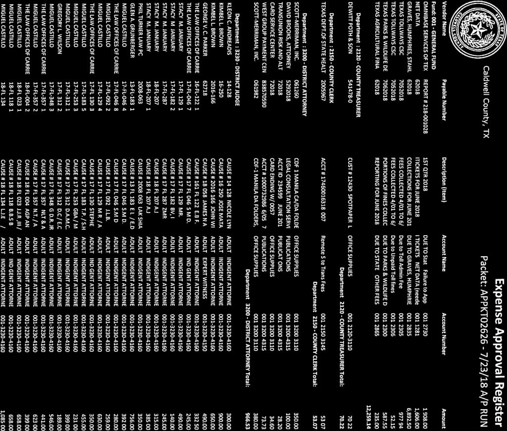
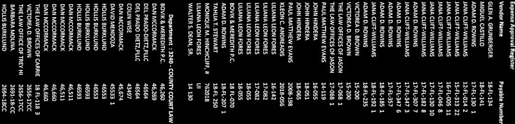
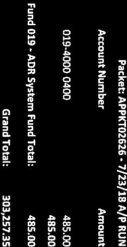
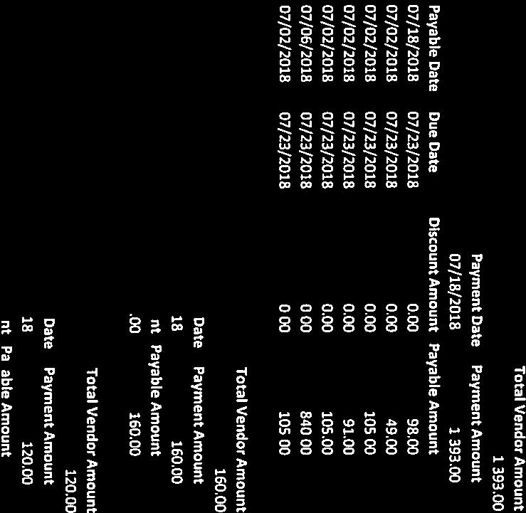
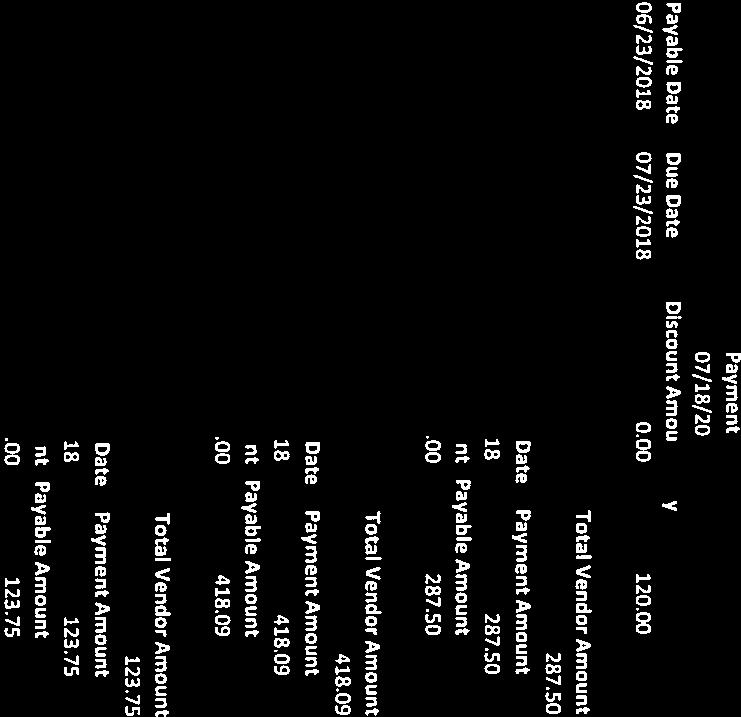
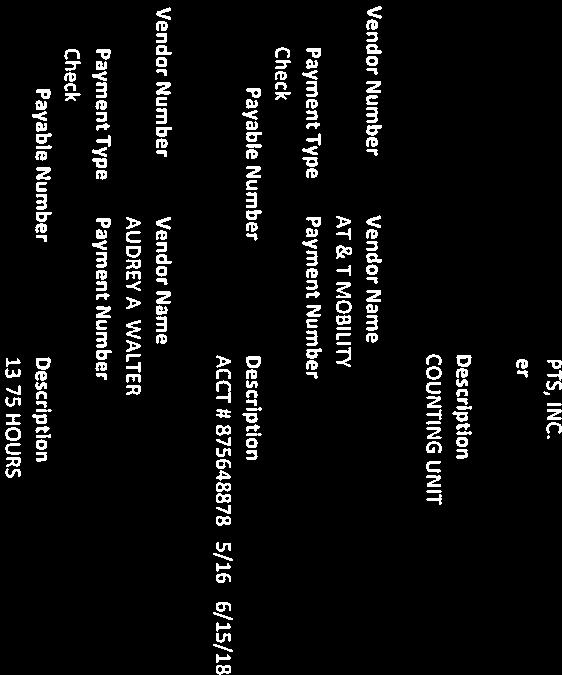
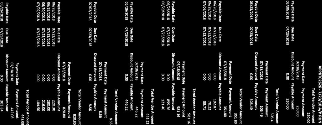
5 CONSENT AGENDA. (The following consent items may be acted upon in one motion). 1. Approve payment of County invoices in the amount of $ 303,
6

7

8


9


10

11


12


13


14

15


16


17


18

19


20


21


22


23


24

25

26

27

28

29
30
31
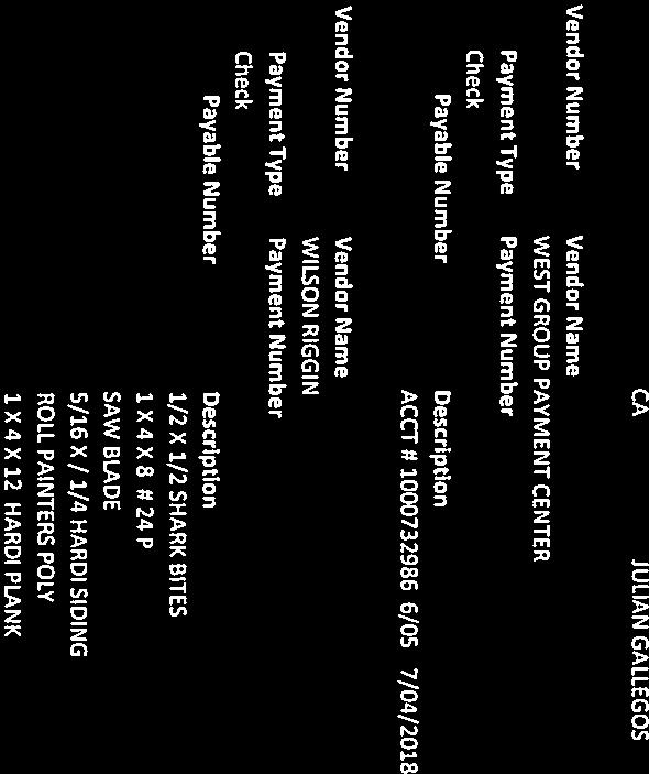
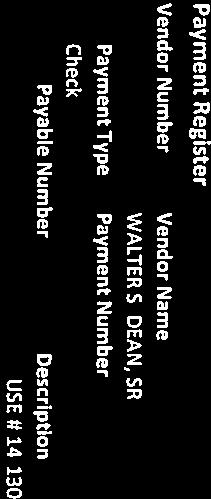
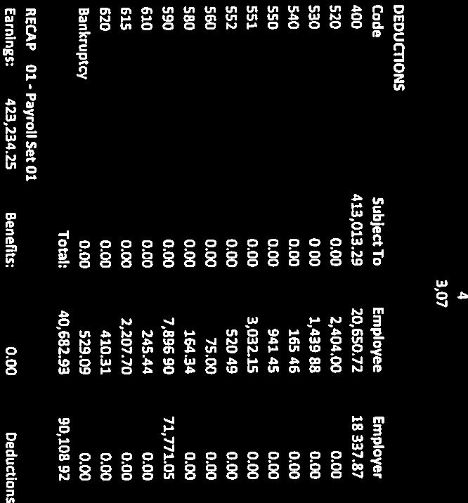
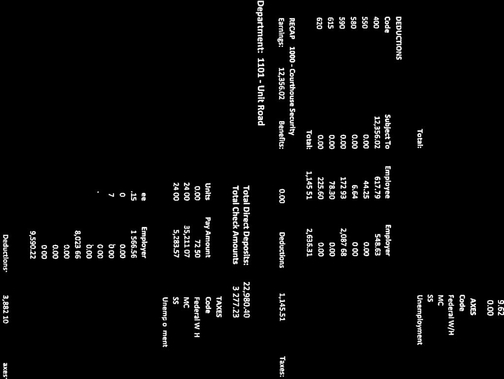
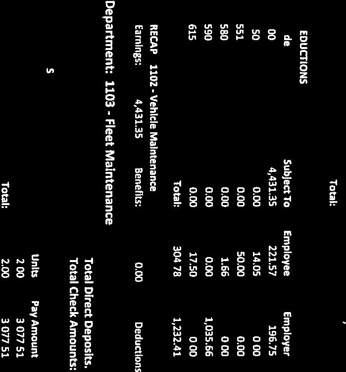
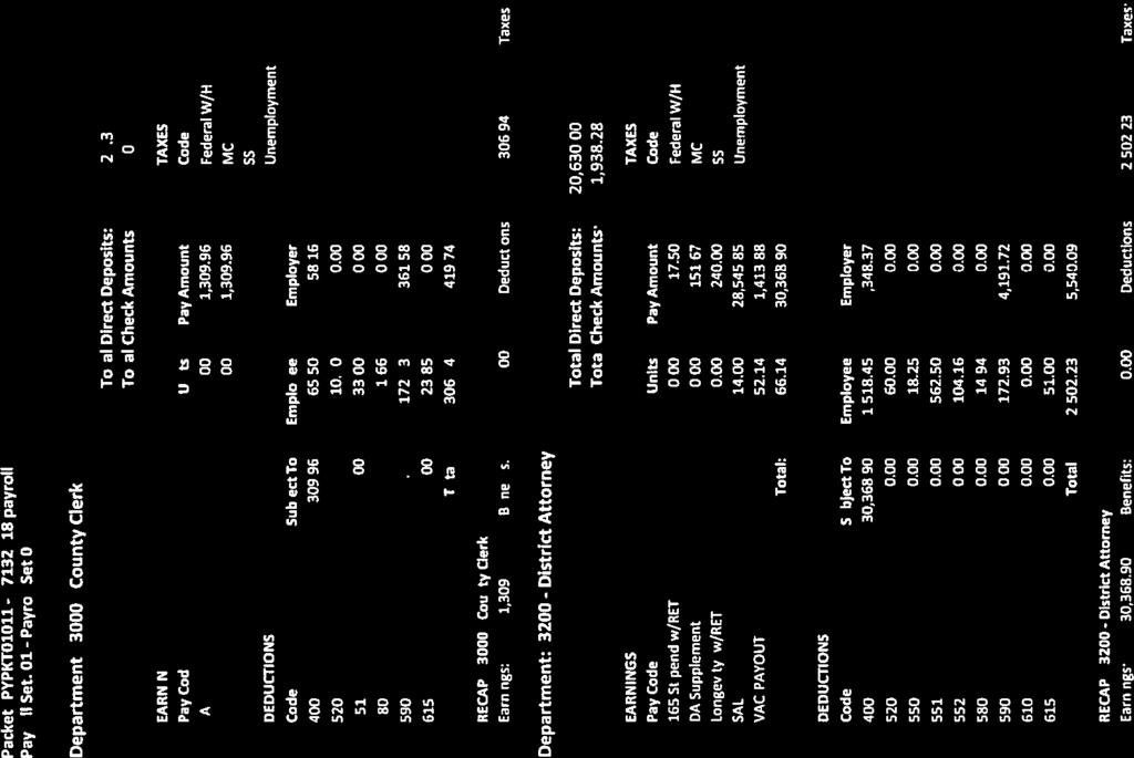
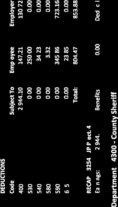
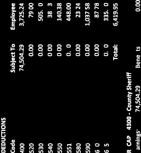
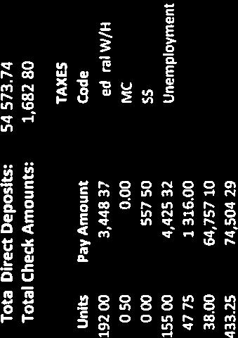
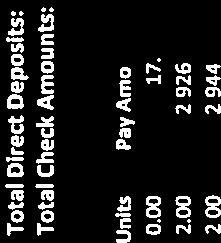
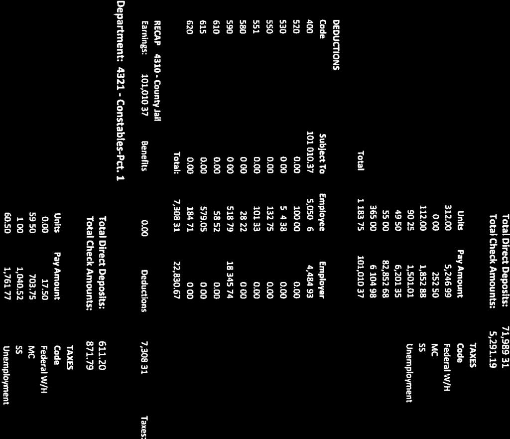
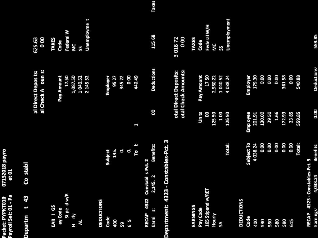
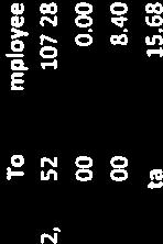
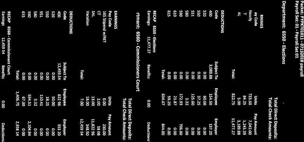
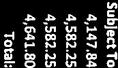
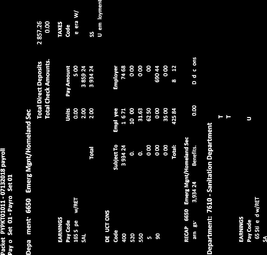
32 2. Ratify re-occurring County payments in the amount of: A. $ 317, (Payroll for 07/01/ /15/2018)


33
34


35
36


37


38


39

40


41


42


43


44


45


46


47


48

49


50

51


52
53 B. $ 95, (Payroll Tax for 07/01/ /15/2018)


54
55 C. $ 35, (Utilities)
56 Bill Name Location Jun-18 Maxwell Water Supply Corp. Hwy 142/CCR 239 & FM 1966 JP MAXWELL WATER SUPPLY CORP. - TOTAL Polonia Water Supply Corp. Caldwell County Unit Rd Polonia Water Supply Corp. Caldwell Co. Prect Civic Dr., Dale, TX POLONIA WATER SUPPLY CORP. - TOTAL Texas Gas Service Caldwell County Jail #2, 1204 Reed Rd CCSO 1, Caldwell County 405 E. Market, Lockhart County Bldg Luling, 510 E Pierce, Luling Caldwell County #2, 401 E. Market, Lockhart Caldwell Cty Juv Prob Dept Caldwell Co. New Building-1703 S. Colorado TEXAS GAS SERVICE - TOTAL 1, City of Lockhart - CALDCO 01 Caldwell Co. Annex, 405 E. Market Caldwell Co. Annex, 405 E. Market CITY OF LOCKHART - CALDCO 01 -TOTAL City of Lockhart - CALDCO 02 Caldwell Co. Annex, 110 S. Main 1, Bkroom, 312 E. San Antonio SERVER RM CC Juvenile Prob. Dept, 312 E. San Antonio CC Annex, CC Courthouse, 401 E. Market CC District Resource Cent, 401 E. Market - DRC Caldwell Co. Annex, 110 S. Main-Sprinkler CC Judicial Center, 1703 S. Colorado 8, CC Judicial Center, 1703 S. Colorado Caldwell Co. Annex, 1196 Reed Dr.-Barn MAINT Caldwell Co. Annex, Blackjack 2, Caldwell Co. Annex, 1204 Reed Dr. CCSO 20, Caldwell Co. Annex, 1403 Blackjack-LW School Caldwell Co. Annex, 1403 Blackjack-Maint Bldg CITY OF LOCKHART - CALDCO 02 - TOTAL 36, City of Luling - CALDWELL Caldwell Co-JP/County Auditor, 508 N. Fannin St Statement date usually end of the month. Caldwell Co-Adult/Juv Serv, 512 E. Fannin St Caldwell Co. Welfare Off, 505 E. Fannin St Caldwell Co Prec. #2, 423 San Marcos Hwy CITY OF LULING - CALDWELL - TOTAL Bluebonnet Electric Caldwell County Precint # Caldwell County Prec Bluebonnet Electric Caldwell County URS Sanitation - meter no: / BLUEBONNET ELECTRIC - TOTAL Total Utilities Paid: 39,773.59
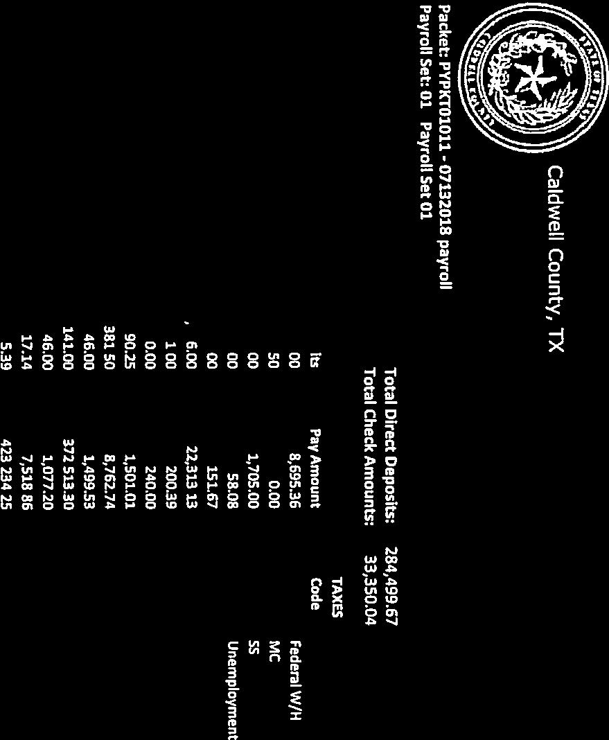
57 D. $ 152, (Department of Motor Vehicle Fees)
58
59 E. $ 402, (Texas Motor Vehicle Sales/Use Tax and Surcharge)
60
61 F. $ 17, (Texas Motor Vehicle Registration Surcharge/Title Application Fees)
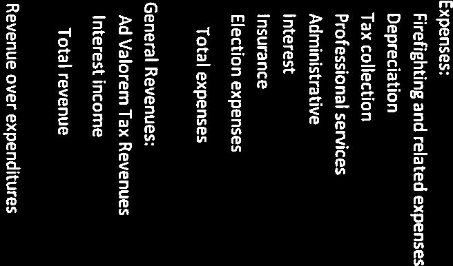
62
63 G. $ 1, (Texas Boat and Boat Motor Sales and Use Tax Report)
64
65 3. Approve June 2018 Tax Collection Report submitted by the Caldwell County Appraisal District.
66
67
68
69 4. Accept ESD financial reporting from Emergency Services District No. 2 (ESD #2) for Fiscal Year Ending December 31, 2017.


70

71

72

73


74


75
76 SPECIAL PRESENTATION Julie Zimmerman Recognition of members of the Ag Committee
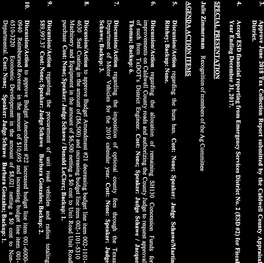
77 ACTION AGENDA ITEMS 5. Discussion/Action regarding the burn ban. Cost: None; Speaker: Judge Schawe / Martin Ritchey; Backup: None.
78 6. Discussion/Action Discussion/Action regarding the allocation of remaining SH130 Concession Funds for improvements on Caldwell County roads and authorizing the County Judge to request approval of such from TxDOT s District Engineer. Cost: None; Speaker: Judge Schawe / Jacque Thomas; Backup: 6.


79


80


81


82

83

84
85 7. Discussion/Action regarding the imposition of optional county fees through the Texas Department of Motor Vehicles for the 2019 calendar year. Cost: None: Speaker: Judge Schawe; Backup: 3.
 each year regarding the imposition or removal of optional fees. Notice must be made to the TxDMV each year by September 1 with new fees taking effect each year on January 1.")
86 July 16, 2018 The Honorable County Judge Re: Imposition of Optional Fees for Calendar Year 2019 Your Honor: County commissioners courts are statutorily required to notify the Texas Department of Motor Vehicles (TxDMV) each year regarding the imposition or removal of optional fees. Notice must be made to the TxDMV each year by September 1 with new fees taking effect each year on January 1. This letter and attachments will provide information on how to submit the calendar year 2019 notification to the TxDMV. The following is a brief description of the local optional fees from Chapter 502 of the Transportation Code: County Road and Bridge Fee (Section ): may not exceed $10; fees collected must be credited to the county road and bridge fund. Child Safety Fee (Section ): may not exceed $1.50; revenue must be used for school crossing guard services; remaining funds must be used for programs to enhance child safety, health, or nutrition, including child abuse intervention and prevention and drug and alcohol abuse prevention. Transportation Project Fee (Section ) applies to Bexar, Cameron, El Paso, Hidalgo, and Webb counties only: may not exceed $10 or $20 for those meeting population requirements under Section (b) and (b-1); revenue must be used for long-term transportation projects. Please complete the attached form, Imposition of Optional Fees, and return to the TxDMV. If your county will keep the same optional fees for calendar year 2019, select OPTION A. If your county will change fees, select OPTION B, and return the form with a copy of the court order. Deadline: Please return the form on or before Monday, August 27, 2018, by to: DMV_OptionalCountyFeeUpdates@TxDMV.gov. (please note the underscore between DMV and Optional) If you have any questions, please contact Tiffany McGehee, Registration Services, at (512) Thank you for your timely response. Sincerely, Jeremiah Kuntz, Director Vehicle Titles and Registration Division Texas Department of Motor Vehicles JK:TT:TM Attachments cc: County tax assessor-collectors
87 TEXAS REGISTRATION FEES EFFECTIVE January 1, 2018 EXPIRES December 31, 2018 STATE LAW ALLOWS THE COLLECTION OF LOCAL FEES AT THE TIME OF VEHICLE REGISTRATION Below are local fees collected with vehicle registration fees through the County Tax Assessor-Collector s office. The total fee on the registration renewal notice includes applicable local fees. Anderson $10.25 Andrews $7 Angelina $10 Aransas $10 Archer $10 Armstrong $10 Atascosa $10 Austin $10 Bailey $10 Bandera $10 Bastrop $10 Baylor $10 Bee $10 Bell $11.50 Bexar $21.50 Blanco $11.50 Borden 0 Bosque $10 Bowie $10 Brazoria $10 Brazos $11.50 Brewster $10 Briscoe $10 Brooks $11.50 Brown $11.50 Burleson $10.75 Burnet $11.50 Caldwell $11.50 Calhoun $10 Callahan $10 Cameron $21.50 Camp $10.50 Carson $10 Cass $10 Castro $10 Chambers $11 Cherokee $10 Childress $10 Clay $10 Cochran $10 Coke $10 Coleman $10 Collin $11.50 Collingsworth $10 Colorado $10 Comal $11.50 Comanche $10 Concho $10 Cooke $10 Coryell $10 Cottle $10 Crane 0 Crockett $5 Crosby $10 Culberson $10 Dallam $10 Dallas $10 Dawson $10 Deaf Smith $10 Delta $10 Denton $11.50 DeWitt $10 Dickens $10 Dimmitt $11.50 Donley $10 Duval $10 Eastland $10 Ector $10 Edwards $11.00 Ellis $10 El Paso $20 Erath $10 Falls $11 Fannin $10 Fayette $10 Fisher $10 Floyd $10 Foard $10 Fort Bend $11.50 Franklin $10 Freestone $10 Frio $11.50 Gaines 0 Galveston $10 Garza $10 Gillespie $11.50 Glasscock $10 Goliad $10 Gonzales $10 Gray $10 Grayson $10 Gregg $9 Grimes $10 Guadalupe $11.50 Hale $10 Hall $10 Hamilton $10 Hansford $10 Hardeman $10 Hardin $10 Harris $11.50 Harrison $11.50 Hartley $10 Haskell $10 Hays $10 Hemphill $5 Henderson $10 Hidalgo $20 Hill $10 Hockley $10 Hood $10 Hopkins $10 Houston $10 Howard $10 Hudspeth $10 Hunt $11 Hutchinson $10 Irion $10 Jack $10 Jackson $10 Jasper $10 Jeff Davis $11.50 Jefferson $10 Jim Hogg $11.50 Jim Wells $11.50 Johnson $11.50 Jones $10 Karnes $10 Kaufman $11.50 Kendall $11 Kenedy 0 Kent 0 Kerr $10 Kimble $10 King 0 Kinney $10 Kleberg $10 Knox $10 Lamar $10 Lamb $10 Lampasas $11.50 La Salle $10 Lavaca $10 Lee $10 Leon $10 Liberty $10 Limestone $10 Lipscomb $10 Live Oak $10 Llano $11.50 Loving 0 Lubbock $10 Lynn $10 Madison $10 Marion $10 Martin $10 Mason $11.50 Matagorda $10 Maverick $11.50 McCulloch $11.50 McLennan $11.50 McMullen 0 Medina $10 Menard $11.50 Midland $10 Milam $10 Mills $11.50 Mitchell $10 Montague $10 Montgomery $10 Moore $10 Morris $10 Motley $10 Nacogdoches $10 Navarro $10 Newton $10 Nolan $10 Nueces $10 Ochiltree $10 Oldham $10 Orange $10 Palo Pinto $10 Panola $1.50 Parker $10 Parmer $10 Pecos $10 Polk $11.50 Potter $10 Presidio $10 Rains $11.50 Randall $10 Reagan $10 Real $10 Red River $10 Reeves $10 Refugio $10 Roberts $5 Robertson $11.50 Rockwall $10 Runnels $10 Rusk $11 Sabine $11 San Augustine $11.50 San Jacinto $11.50 San Patricio $11.50 San Saba $10 Schleicher $10 Scurry $10 Shackelford $10 Shelby $11.50 Sherman $10 Smith $11.50 Somervell $10 Starr $10 Stephens $10 Sterling 0 Stonewall $10 Sutton $10 Swisher $10 Tarrant $10 Taylor $10 Terrell $10 Terry $10 Throckmorton $10 Titus $10 Tom Green $11.50 Travis $11.50 Trinity $11.50 Tyler $11 Upshur $10 Upton $5 Uvalde $10 Val Verde $10 Van Zandt $11.50 Victoria $10 Walker $10 Waller $10 Ward 0 Washington $10 Webb $20 Wharton $10 Wheeler $6.50 Wichita $10 Wilbarger $10 Willacy $10 Williamson $11.50 Wilson $10 Winkler $7.50 Wise $10 Wood $10 Yoakum $10 Young $10 Zapata $11.50 Zavala $11.50 PASSENGER VEHICLES / TRUCKS 6,000 lbs. or less = $50.75 The annual registration fee for a passenger vehicle (including a motor bus or private bus) or truck with a gross vehicle weight of 6,000 lbs. or less is $50.75, plus applicable fees and local county fees. Note: The gross vehicle weight of a truck is determined by adding the empty weight of the vehicle and the heaviest load that will be carried by the vehicle (carrying capacity) during the registration year. TRAILERS / TRAVEL TRAILERS 6,000 lbs. or less = $45.00 The annual registration fee for a trailer or travel trailer (if the trailer requires registration) with a gross vehicle weight of 6,000 lbs. or less is $45.00, plus applicable fees and local county fees. ALL VEHICLES 6,001 lbs. 10,000 lbs. = $54.00 The annual registration fee for a vehicle with a gross vehicle weight of 6,001 lbs. 10,000 lbs. is $54.00, plus applicable fees and local county fees. Note: The gross vehicle weight of a truck is determined by adding the empty weight of the vehicle and the heaviest load that will be carried by the vehicle (carrying capacity) during the registration year. WEIGHT BASED REGISTRATION FEES Vehicles 10,001 lbs. or more will pay the following registration fee*, plus applicable and local county fees 10,001-18,000 lbs. $ ,001-25,999 lbs. $ ,000-40,000 lbs. $ ,001-54,999 lbs. $ ,000-70,000 lbs. $ ,001-80,000 lbs. $ Over 80,000 lbs. Varies *Does not include diesel fees for commercial vehicles MOTORCYCLES / MOPEDS = $30.00 The annual registration fee for a motorcycle or moped is $30.00, plus applicable fees and local county fees. TEXAS DEPARTMENT OF MOTOR VEHICLES VEHICLE TITLES AND REGISTRATION DIVISION FEE CHART 1C (REV. 1/2018)


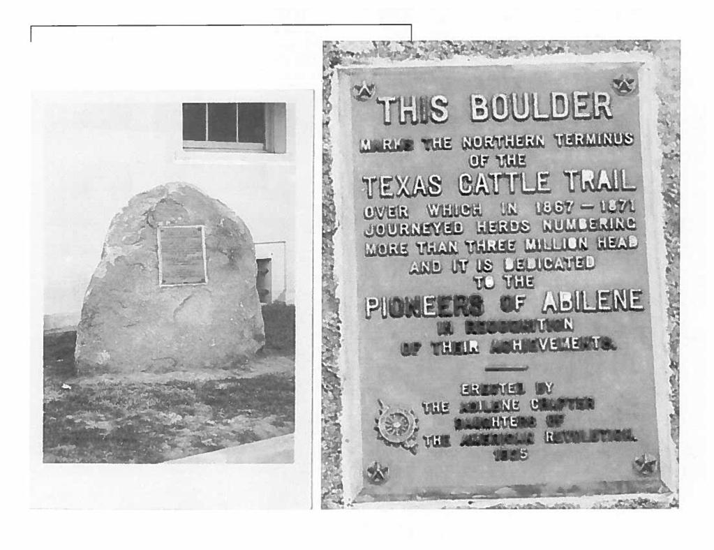
88
89 8. Discussion/Action to approve Budget Amendment #21 decreasing budget line item / Seal Coating in the amount of ($6,500) and increasing budget line item / Machinery and Equipment in the amount of $6,500 netting a $0 cost to Unit Road Unit Road purchase. Cost: None; Speaker: Judge Schawe / Donald LeClerc; Backup: 1.
90 DATE: July CALDWELL COUNTY BUDGET TRANSFER / AMENDMENT REQUEST FY DEPARTMENT: Unit Road A B C D E CURRENT REVISED BUDGET REQUESTED BUDGET FUND/DEPARTMENT/LINE Account AMOUNT CHANGE AMOUNT (EX.001-xxxx-xxxx) Description (Total budgeted amount) (add/subtract) (NEW budgeted amount) Seal Coating 200, (6,500.00) 193, Machinery and Equipment 170, , , TOTALS $ 370, $ - $ 370, EXPLAIN SPECIFICALLY WHY MONIES ARE BEING TRANSFERRED INTO EACH LINE: Budget Amendment is needed to meet the cost of two (2) mobile radios and three (3) hand held radios ($15,411.37) Passed and approved in Commissioners Court by a vote of aye and nay on this day of, Recorded By Caldwell County Judge Attested By Caldwell County Clerk
91 9. Discussion/Action regarding the procurement of unit road vehicles and radios totaling $89, Cost: None; Speaker: Judge Schawe / Barbara Gonzales; Backup: 2.
92 Commissioners Court-Monday, July 23, 2018 County Auditor s Office / Unit Road Procurement of Two (2) Trucks and Radios exceeding $50,000 History: At the June 25, 2018 Commissioners Court meeting, Unit Road was authorized to procure two (2) trucks and radios from available funds in Machinery and Equipment Account (Line Item: ). Discussion Items: Purchasing Policy VII. Bidding Process and Procedures discusses Category 5 Purchases over $50,000 must be approved by Commissioners Court. Notable Budget Items Funds are available and will be transferred from to Machinery and Equipment in the amount of $6,500 to fund the remainder of this fixed assets totaling $87, Recommendation to Commissioner s Court County Auditor s Office respectfully recommends the following: The Commissioners Court to Approve the attached proposal from Gunn Chevrolet / Buy Board Contract # to purchase two (2) 2018 Chevrolet Silverado 2500 HD 2WD Crew Cab Pickups and radios totaling $87, Passed and approved in Commissioners Court by a vote of aye and nay on this day of Recorded By Caldwell County Judge Attested By Caldwell County Clerk


93
94 10. Discussion/Action to approve Budget Amendment #22 increased budget line item / Reimbursed Revenue in the amount of $10,695 and increasing budget line item / Economic Development in the amount of $8,021 netting a $0 cost to Non-Departmental. Cost: None; Speaker: Judge Schawe / Barbara Gonzales; Backup: 1.
95 DATE: July 23, 2018 CALDWELL COUNTY BUDGET AMENDMENT REQUEST FY DEPARTMENT: Non-Departmental A B C D E CURRENT REVISED BUDGET REQUESTED BUDGET FUND/DEPARTMENT/LINE Account AMOUNT CHANGE AMOUNT (EX.001-xxxx-xxxx) Description (Total budgeted amount) (add/subtract) (NEW budgeted amount) Reimbursed Revenue $ (14,000.00) $ (10,695.00) (24,695.00) Economic Development 30, , , TOTALS $ 16, $ (2,674.00) $ 13, EXPLAIN SPECIFICALLY WHY MONIES ARE BEING TRANSFERRED INTO EACH LINE: Accounting for A/R and / or receipts received on the behalf of City of Lockhart and City of Luling for Aerial Mapping services approved by CCT on 07/24/2017; obligation by Caldwell County paid out of Economic Development funds to Flyer View Group Passed and approved in Commissioners Court by a vote of aye and nay on this day of, Recorded By Caldwell County Judge Attested By Caldwell County Clerk
96 11. Discussion/Action authorizing Commissioners Court to submit an Antiquities Permit Application to the Texas Historical Commission for purposes of constructing a Caldwell County Trail Drivers marker on the Caldwell County Courthouse grounds. Cost: None; Speaker: Commissioner Theriot / Ronda Reagan; Backup: 4.
97 ANTIQUITIES PERMIT APPLICATION Historic Buildings and Structures GENERAL PROJECT INFORMATION Please complete the following. See detailed instructions, How to Complete the Antiquities Permit Application for Historic Buildings and Structures, for additional information. 1. Property Name and Location NAME OF STATE ANTIQUITIES LANDMARK ADDRESS CITY COUNTY ZIP CODE 2. Project Name NAME OR BRIEF DESCRIPTION OF PROJECT WORK 3. Applicant (Owner or Controlling Agency) OWNER/AGENCY REPRESENTATIVE TITLE ADDRESS CITY STATE ZIP CODE PHONE 4. Architect or Other Project Professional NAME/FIRM REPRESENTATIVE TITLE ADDRESS CITY STATE ZIP CODE PHONE 5. Construction Period PROJECT START DATE PROJECT END DATE PERMIT CATEGORY Please select the category that best describes the proposed work. (Pick one.) Preservation Reconstruction Rehabilitation Architectural Investigation Restoration Hazard Abatement Relocation Demolition New Construction ATTACHMENTS For all projects, please attach the following: Written description of the proposed project; Project documents (plans, specifications, etc.); and Photographs of the property showing areas of proposed work. Application reports may be required based on the project work or at the request of Texas Historical Commission staff. Please indicate if the following are provided with your application: Historic Structure Report Architectural Documentation Historical Documentation Archeological Documentation
98 PROPERTY NAME: Antiquities Permit Application for Historic Buildings and Structures, Continued COUNTY: CERTIFICATIONS The applicant and project professional must complete, sign, and date the following certifications. The Texas Historical Commission's Rules of Practice and Procedure and the Secretary of the Interior's Standards for the Treatment of Historic Properties are available through links from the Antiquities Permits page on our website at Standard permit terms and conditions are listed in the detailed instructions, How to Complete the Antiquities Permit Application for Historic Buildings and Structures. Special conditions may also be included in a permit. Please contact Texas Historical Commission staff with any questions regarding the Rules, our procedures, and permit requirements prior to signing and submitting a permit application. Applicant's Certification I,, as legal representative of the Applicant,, do certify that I have reviewed and approved the plans and specifications for this project. Furthermore, I understand that failure to conduct the project according to the approved contract documents and the terms of this permit may result in cancellation of the permit. Signature Date Project Professional's Certification I,, as legal representative of the Firm,, do certify that I am familiar with the Texas Historical Commission's Rules of Practice and Procedure and the Secretary of the Interior's Standards for the Treatment of Historic Properties. Furthermore, I understand that submission of a completion report is required for all Historic Buildings and Structures Permits. Furthermore, I understand that failure to conduct the project according to the Rules, Standards, approved contract documents, and the terms of this permit may result in cancellation of the permit. Signature Date SUBMISSION Please submit the completed permit application in hard copy with original signatures to the mailing or physical address below, or electronically with scanned signatures to hspermit@thc.texas.gov. Attachments, including plans and photographs, must be sent to the mailing address below or delivered to 108 West 16th St., Second Floor, Austin, TX
99 THIS BOULDER MARKS THE SOUTHERN TRAIL OF THE GREAT TEXAS CATTLE TRAILS OVER WHICH IN HERDS NUMBERING MORE THAN THREE THOUSAND AT A TIME JOURNEYED THROUGH LOCKHART AND IS DEDICATED TO THE PIONEERING CALDWELL COUNTY TRAIL DRIVERS IN RECOGNITION OF THEIR ACHIEVEMENTS IN IMPROVING THE COUNTY'S ECONOMY. ERECTED BY THE CALDWELL COUNTY HISTORICAL COMMISSION IN HONOR OF THE 150TH ANNIVERSARY OF THE CHISHOLM TRAIL.


100
101 12. PUBLIC HEARING at 9:30AM: for the purpose of receiving public comment regarding the adoption of proposed amendments to the Caldwell County Development Ordinance. Cost: None; Speaker: Commissioner Theriot; Backup: 83.
102 CALDWELL COUNTY DEVELOPMENT ORDINANCE Adopted January 18, 2011 Amended
103 TABLE OF CONTENTS 1.0 AUTHORITY COORDINATION WITH OTHER JURISDICTIONS ENFORCEMENT AND PENALTIES AUTHORITY OF THE COMMISSIONERS COURT DEFINITIONS SUBDIVISION PLATTING PROCEDURES GENERAL PRE-APPLICATION CONFERENCE EXCEPTIONS TO PLATTING REQUIREMENTS Requirements for Exempted Subdivisions PRELIMINARY PLAT REQUIREMENTS Information Provided with the Preliminary Plat Previously Approved Preliminary Plat Expiration of Approved Preliminary Plat PROCEDURES FOR PHASED SUBDIVISIONS FINAL PLAT REQUIREMENTS AND PROCEDURES Information to be Provided with the Final Plat certifications and acknowledgements to be provided with final plat Additional Items to be Submitted with the Final Plat Submittal Procedures for Final Plat Expiration of Approved Final plat SHORT FORM PLATS FISCAL SECURITY FOR SUBDIVISION IMPROVEMENTS Construction Bonds Maintenance Bonds Forms of Security Collection of Security Release of Security SUBDIVISION PLATS WITH PRIVATE STREETS CANCELLATION OF SUBDIVISION PLATS REVISION OF SUBDIVISION PLATS VARIANCE PROCEDURES CONSTRUCTION PERMIT PROCEDURES GENERAL i
104 4.2 SUBDIVISION CONSTRUCTION PERMIT PROCEDURES Subdivision Construction Plan elements Subdivision Utility Design general Requirements Subdivision Erosion & Sedimentation Control Requirements Subdivision Construction Permit Submittal Requirements Private Street Requirements COMMERCIAL SITE CONSTRUCTION PERMIT PROCEDURES Pre-Application Conference Requirements for Commercial Site Construction Permit Commercial Site Plan Exemptions RESIDENTIAL CONSTRUCTION PERMIT MANUFACTURED RENTAL HOME COMMUNITY STANDARDS Plat Required Construction Plans Additional Requirements WORK IN THE PUBLIC RIGHT-OF-WAY PERMIT PROCEDURES FLOODPLAIN REVISION PROCEDURES WAIVER PROCEDURES OTHER DEVELOPMENT PROCEDURES CONSTRUCTION INSPECTION PROCEDURES PROCEDURES TO CONVERT PRIVATE STREETS TO PUBLIC STREETS PROCEDURE TO CANCEL AN EASEMENT OR RIGHT-OF-WAY Other Cancellation Requests FEES SEVERABILITY A. APPENDIX A SUBDIVISION LAYOUT REQUIREMENTS A.1. GENERAL REQUIREMENTS A.2. RURAL SUBDIVISIONS A.3. REQUIREMENTS FOR URBAN SUBDIVISIONS A.4. REQUIREMENTS FOR PRIVATE STREETS A.5. CONSERVATION SUBDIVISION INCENTIVES A.6. REQUIREMENTS FOR FLAG LOTS B. APPENDIX B STREET DESIGN REQUIREMENTS B.1. STREET GEOMETRIC STANDARDS B.2. GENERAL STREET DESIGN REQUIREMENTS ii
105 B.3. CURB/GUTTER STREET STANDARDS B.4. RURAL (SHOULDER-SECTION) STREET STANDARDS B.5. DESIGN OF PRIVATE GRAVEL ROADWAYS B.6. COUNTY AND STATE HIGHWAYS B.7. STREET NAMES AND STREET SIGNS B.8. PAVEMENT DESIGN B.9. MAJOR STRUCTURES AND BRIDGES C. APPENDIX C WORK IN THE PUBLIC RIGHT-OF-WAY C.1. PERMIT REQUIREMENT FOR WORK IN THE PUBLIC RIGHT-OF-WAY C.2. REQUIREMENTS FOR DESIGN AND CONSTRUCTION OF DRIVEWAYS D. APPENDIX D EASEMENTS AND RIGHT-OF-WAY REQUIREMENTS E. APPENDIX E DRAINAGE DESIGN REQUIREMENTS E.1. DRAINAGE DESIGN GENERAL REQUIREMENTS E.2. DRAINAGE DESIGN CRITERIA F. APPENDIX F EROSION AND SEDIMENT CONTROL REQUIREMENTS G. APPENDIX G PROTECTION OF STREAMBANKS AND BLUFFS G.1. STREAM SETBACK REQUIREMENTS G.2. BLUFF PROTECTION G.3. EXEMPTIONS G.4. WAIVER H. APPENDIX H FLOODPLAIN REVISION REQUIREMENTS iii
106 1.0 AUTHORITY This Development Ordinance constitutes the rules governing subdivision and platting of property and the permitting of site and subdivision construction within the unincorporated areas of Caldwell County. It is intended to promote the health, safety, morals, and general welfare of the County and the safe, orderly, and healthful development of the unincorporated areas, these issues being hereby declared to be worthwhile public purposes and in the public interest. When in conflict with any previously enacted subdivision regulations for Caldwell County, these subdivision regulations shall control. The ordinances and requirements described in this and the following chapters, articles and sections, shall constitute and be designated the Caldwell County Development Ordinance and may be so cited. This Caldwell County Development Ordinance is also herein referred to as these Regulations. This ordinance regulates the development of property within the jurisdiction of Caldwell County, Texas under authority set forth in the following Texas statutes, including but not limited to: A) Texas Local Government Code Chapter 232 County Regulation of Subdivisions; Chapter 242 Authority of Municipality and County to Rregulate Subdivisions In and Outside Municipality s Extraterritorial Jurisdiction; Chapter 245 Issuance of Local Permits B) Texas Transportation Code Chapter 251 General County Authority Relating to Roads and Bridges Chapter 252 Systems of County Road Administration Chapter 253 County Improvement of Subdivision Roads Chapter 254 Drainage on Public Roads Chapter 255 County Regulation of Sight Distances C) This Development Ordinance has been approved by the Caldwell County Commissioners Court as a means of implementing County responsibilities described in the Texas sstatutes listed above and as required by other statutes applicable to counties. These responsibilities mandate that Caldwell County shall provide for the safety, health and welfare of the general public through its authority to: 1) 2) 3) 4) Administer the orderly development of real property in accordance with the Texas Local Government Code and other applicable regulations; Require that roadways and drainage facilities be arranged, designed, and built in a manner consistent with sound planning and engineering practices and established standards of construction; Require that proposed development demonstrate the ability to provide adequate water and wastewater service and capacity; Protect the County s natural resources in a manner compatible with sound development goals and practices; 1
107 5) 6) 7) 8) Protect the citizens of Caldwell County from an unreasonable tax burden resulting from substandard design and construction of public infrastructure or inadequate funding for maintenance of public facilities; Require that the owner of the tract to be subdivided execute good and sufficient construction and maintenance bonds or alternative fiscal surety; Require that lot and block monumentation be set by an RPLS before recordation of the plat; and Support the orderly and coordinated development of real property within the extra-territorial jurisdiction of local municipalities. Section 3.0 of this ordinance (Subdivision Platting Procedures) addresses procedures for Preliminary Plat approval, Final Platting, and for plat cancellation and revisions. Section 4.0 (Construction Permit Procedures) provides guidelines for obtaining a subdivision or site construction permit including construction plans requirements and construction inspection. Technical design specifications are found in the Appendices. 1.1 COORDINATION WITH OTHER JURISDICTIONS All authority specifically provided to Caldwell County, or agreed to between Caldwell County and other local, state and/or federal agencies, shall be applied to the fullest extent. Specific platting and permitting requirements are subject to interlocal agreements which may exist for governing the extraterritorial jurisdictions surrounding incorporated cities within Caldwell County. In the event no interlocal agreement exists, all development must be approved by both the municipality and Caldwell County with final approval to be granted by the County. To the extent that ordinances conflict, the more stringent provisions shall prevail. In addition to compliance with the subdivision regulations of Caldwell County and with municipalities having extraterritorial jurisdiction, the development and use of real property in Caldwell County may be subject to regulation by other jurisdictions including the Texas Commission on Environmental Quality (TCEQ), the U.S. Corps of Engineers, FEMA, U.S. EPA, U.S. Fish and Wildlife, and other County regulations. 1.2 ENFORCEMENT AND PENALTIES A) Section of the Texas Local Government Code provides for the enforcement of State subdivision laws and portions of these regulations. B)A) Under Section , aa person commits an offense if that person knowingly or intentionally violates certain a requirements of these regulations, including the Platting and Engineering Guidelines incorporated as appendices. That offense is a Class B Misdemeanor as defined by the Texas Local Government Code, as amended. Formatted: Numbered + Level: 1 + Numbering Style: A, B, C, + Start at: 1 + Alignment: Left + Aligned at: 0" + Tab after: 0.25" + Indent at: 0.25" Formatted: Bullets and Numbering C)B) There exist many other required guidelines through additional State and Federal statutes and additional County regulations that constitute an offense in which penalty ranges include misdemeanors and felonies. D)C) Under Texas law, a person may be jointly responsible as a party to an offense if the person (acting with intent to promote or assist the commission of the offense) solicits, encourages, directs, aids, or attempts to aid another person to commit the offense. Thus, a real estate agent or broker, a lender, an attorney, a surveyor, an engineer, a title insurer, or any other person who assists in violating these Regulations may also face criminal penalties. 2
108 E)D) The Criminal District Attorney of Caldwell County, Texas, Attorney General, or other prosecuting attorney, shall have the power to enforce these Regulations, and any additional State and Federal statutes or additional County regulations that constitute an offense, by filing an action in a court of competent jurisdiction to: 1) 2) 3) 4) enjoin the violation or threatened violation of any requirement established or adopted in these Regulations by the Caldwell County Commissioners Court; recover damages in an amount adequate for the County to undertake any construction or other activity necessary to bring about compliance with a requirement established by these Regulations; pursue any remedy authorized by State or federal law, including the remedies contained in Sections , , and of the Texas Local Government Code, as amended; and / or prosecute criminal violations of these Regulations. F)E) No party shall file for record or have recorded in the official records of the County Clerk's office any plat of a subdivision or re-subdivision without first securing approval thereto by the Commissioners Court, in lawful, open session. Further, no party so subdividing or re-subdividing of any real estate shall use the subdivision's or re-subdivision's description in any deed of conveyance or contract of sale delivered to a purchaser unless and until said plat has been duly authorized as aforesaid and the plat has actually been filed for record with the Clerk of the County Court. G)F) All developers must comply with state and federal laws and regulations, and shall comply with Title VIII of the Civil Rights Act of 1968 (as amended), by not directly or indirectly discriminating on the basis of race, religion, sex, or national origin in lot marketing and advertising, the rendering of lot services, and requiring terms and conditions on lot sales and leases. 1.3 AUTHORITY OF THE COMMISSIONERS COURT A) B) C) D) E) The Commissioners Court may adopt rules of procedure to govern its actions taken under this ordinance. After public hearing, the Court may adopt rules that shall be consistent with the provisions of this ordinance and shall become effective upon being filed with the County Clerk. Decisions by the Commissioners Court concerning the specific interpretation of these regulations shall become a part of these regulations upon filing with the Office of the County Clerk. Disapproval of a plat by the Commissioners Court shall be deemed a refusal by the County concerning any responsibility for maintenance of any public infrastructure until the Court has entered an order accepting such improvements for maintenance. No County Employee shall enter a subdivision for the purpose of maintaining public infrastructure, unless and until such roads, utilities and drainage facilities have been installed as per approved plans, and such improvements have been accepted by the Commissioners Court. No person shall create a subdivision of land either by sale, or lease, or otherwise, within Caldwell County without complying with the provisions of these regulations, unless the Commissioners Court acknowledges that the division of land is exempt from platting as an Exempted Subdivision. 3
109 F) In addition to any other remedy provided by law, the Commissioners Court shall have the right to enjoin any violation of these regulations by injunction issued by a court of competent jurisdiction. 2.0 DEFINITIONS As used herein: County means Caldwell County, Texas; Commissioners Court means the Commissioners Court of Caldwell County, Texas; singular nouns and pronouns shall include the plural; and the masculine gender shall include the feminine gender where necessary for a correct meaning. For the purpose of these Regulations, the following terms, phrases, words, and their derivations shall have the meaning ascribed to them in this Section. All other words and terms shall have their usual force and meaning. ADT Average Daily one-way Trips. Acceptance of Improvements Upon successful completion of the performance period, the County will accept improvements designated for public maintenance into its roadway system. Alley A right-of-way which is used only for secondary access to individual properties which have their primary access from an adjacent street or joint use access easement (JUAE) which has direct access to a public street. All-weather surface road A street, road, or drive that is constructed with base material and has a hard surface to ensure access by ambulance, fire trucks, and other emergency vehicles under all weather conditions. Applicant The owner, person or entity applying for any permit, approval, variance or waiver under this ordinance. Approval of Improvements - Upon successful completion of the construction of improvements as defined within this Ordinance, approval of those improvements will be acknowledged by the County and the performance period will begin. Bluff Limited to a bluff with a vertical change in elevation in excess of 20 feet and an average gradient in excess of 33 percent. Building Line A line beyond which buildings must be set back from the lot or property line. Chip Seal A pavement surface treatment that combines layers of asphalt and fine aggregate. Also known as two course surface treatment or asphaltic surface treatment. Collector Street A street or road that collects traffic from other streets and serves as the most direct route to another collector, minor arterial, major arterial, or state highway. Commercial Site Construction All construction, site grading, or addition of impervious cover on a parcel of land not otherwise exempted under this ordinance. The following are not considered commercial construction: single family residential; two-family (duplex); or three family (triplex) residential; garages, sheds, barns, swimming pools, gardens or other ancillary out-buildings associated with one to three family residences; conservation open space; barns or agriculture 4
110 structures not intended for common use by the public; or improvements to increase the agricultural value of property being used for agricultural purposes with fewer than 50 average-daily trips per day. Commissioners Court The Caldwell County Commissioners Court; also referred to as the Court. County Commissioner - The elected Commissioner of a precinct in Caldwell County in which a subdivision or development is located, or the County Commissioner s designated agent. County Engineer The Professional Engineer (PE) appointed by the Commissioners Court to that position or the County s designated agent or engineer employed by the county. County Representative The designated agent or employee of the County appointed to review, inspect, administer or implement provisions of this and / or other County ordinances. County Review Coordinator The designated agent or employee of the County appointed to perform administrative reviews and receive submittals under this ordinance. County Road Any public road or street in which the County has a public interest and has been accepted for maintaineanced by the County and is not within the incorporated limits of a city and is not a state highway. Designated 100-year Floodplain Any area adjacent to a stream or water course which, on the average, has a one percent (1%) chance of being inundated by flood waters in any given year; also referred to as the floodplain or Special Flood Hazard Area (SFHA). Developer Any owner, or authorized agent thereof, engaging in subdivision of property, except as specifically exempted under this ordinance. Also referred to as Subdivider or Applicant. Development Subdivision of real property, construction of roads and drainge improvements within a subdivision, commercial site construction or construction to alter an existing regulated floodplain. Development Agreement A legally binding agreement entered into by a private party or entity and the County which delineates the conditions for a particular development wherein various concessions to the technical requirements of Development Ordinance may be made in exchange for a mutually agreeable alternate standard which meets the intent of the Ordinance and is in the best interest of both parties. Driveway An access facility from a street or road for the use by the owners or others. Engineer A person who is licensed by the State of Texas as a professional engineer to practice engineering; also referred to as a Professional Engineer (PE). Excavating The mechanical removal of earth material. Exempted Subdivision Those subdivisions of land that are exempted from platting requirements as provided in Section of the Texas Local Government Code. Extra-Territorial Jurisdiction (ETJ) Land located outside of a City s incoporated limits over which the City has jurisdiction under Chapter 42 of the Texas Local Government Code. 5
111 Fill Any act by which earth, sand, gravel, rock or similarly approved material is deposited, placed, pushed, pulled or transported to a place other than the place from which it is excavated and the materials so placed. Final Plat A map or drawing of a proposed subdivision prepared in a manner suitable for recording in the County records and prepared in conformance with any conditions of preliminary approval previously granted by the Commissioners Court. Fiscal Security A bond or funds deposited to secure the construction and performance of improvements required to support the street and drainage requirements related to a subdivision plat or site plan. Flag Lot A lot which has street frontage via a slender strip of land conforming to the subdivision layout requirements of this ordinance. Flood Damage Prevention Ordinance The set of rules approved by the Commissioners Court for the purpose of minimizing public and/or private losses due to flood conditions. Floodway The channel of a river or other watercourse and the adjacent land areas that must be reserved in order to discharge the base flood without cumulatively increasing the water surface elevation more than a designated height. Improvements Street and drainage construction as required by this Development Ordinance to support the functionality and safety of a proposed development. Groundwater Conservation District Any district or authority created under Chapter 35 of the Texas Water Code to regulate or manage groundwater. HMAC Hot Mix Asphaltic Concrete. Industrial Street A street or road intended primarily to serve traffic within an existing or proposed industrial development. Inspector Designee of the Commissioners Court charged with making applicable inspections under this ordinance. Interlocal Agreement Agreement between Caldwell County and a municipality drafted under the authority of House Bill 1445 defining the subdivision and construction permit review procedures and terms of the shared authority over land within the ETJ of the municipality. Joint Use Access Easement (JUAE) An agreement defining the terms and conditions related to the use of shared access driveways. Lot A single defined area of land, regardless of size, identified within a subdivision plat by a number. Major Arterial A major traffic artery, carrying higher volumes of traffic, more or less continuously, which is intended to connect remote parts of the county and to act as a principal connecting street with other county roads and state highways. Manufactured Rental Home Community A parcel of land that is separated into two or more spaces or lots that are rented, leased, or offered for rent or lease without a purchase option; for a term of less 6
112 than sixty (60) months, for the installation of manufactured homes for use and occupancy as residences. Minor Arterial A significant traffic artery, carrying high volumes of traffic, more or less continuously, which is intended to connect remote parts of the county and to act as a connecting street with other county roads and state highways. Nonconforming Subdivision A subdivision of land or a description of land for sale or resale that was platted or filed with the County Clerk prior to May 9, 1983 and which subdivision results in public access, but for which a plan or plat has not been authorized for recording or recorded by the Caldwell County Commissioners Court. Occupancy To make use for residential, commercial, or industrial purposes. Onsite Sewage Facility (OSSF) A wastewater system designed to treat and dispose of less than 5,000 gallons per day of effluent on the same property that produces the wastewater. Open Space A land use which supports quality of life by limiting certain development or other activities on specific parcels. Natural open spaces include wooded areas, prairies, creeks and greenbelts which limit access. Limited development open spaces include parks, practice fields, detention facilities, floodways, non-structural agricultural uses (excludes large chicken barns, concentrated animal feeding operations, etc.), and similar uses with significant limits on impervious cover and vertical development. Open space specifically does not include golf courses. Organized Disposal System Any public or private system for the collection, treatment and disposal of sewage operated in accordance with the terms and conditions of a permit from the Texas Water Development Board, Texas Commission on Environmental Quality, and the Texas Department of State Health Services. Original Tract of Land A tract of land which existed in its current legal configuration prior to September 1, Parcel A Lot or Tract of land Pavement The road bearing surface layer, on a private or public road, consisting of concrete, asphalt concrete or two applications of asphalt material each covered with aggregate and generally designed for a twenty (20) year life expectancy. Performance Period A two-year period which begins after County approval of the constructed improvements during which the improvements are evaluated for adequacy with respect to design and construction, and throughout which the Subdivider retains responsibility for maintenance. This period typically ends when either the County accepts the improvements for public maintenance or the Property Owners Association takes responsibility for private maintenance. Pre-application Conference A meeting between the owner or his agent, the County Commissioner, and County staff (as deemed appropriate by the County Commissioner) to discuss a possible development or subdivision. Preliminary Plat A map of a proposed subdivision illustrating the features of the development for review and preliminary approval by the Commissioners Court, but not suitable for recording in the County Records. 7
113 Private Street A right-of-way or road designated for vehicular access to adjacent properties which has been recognized by the County via plat approval or other formal acknowledgement by Commissioners Court and has not been accepted by a public entity for maintenance. Property Owners Association A not-for-profit organization established for the purpose of owning and managing the common land or amenities of a property and whose documents have been accepted and/or approved by the County with membership in an association comprised of more than one property; also referred to as a Home Owners Association. Public Street A public right-of-way, however designated, dedicated, or acquired, which provides vehicular access to adjacent properties; also referred to as a county road, city street, or state highway. QA/QC Quality Assurance / Quality Control. Private Gravel Roadway A roadway that is designed for use by one hundred (100) or less vehicle trips per day determined by an engineering survey and approved by the County. Registered Professional Land Surveyor (RPLS) A person who is licensed to practice public surveying by the State of Texas; also referred to as a Professional Surveyor. Revised Plat An instrument used to revise or amend the division of land that has previously been approved as a Final Plat, by the Commissioners Court; also referred to as a revised subdivision. Residential Structure A structure that is manufactured or constructed to house a single family, two families (duplex) or three families (triplex). Roadway The vehicle travel surface, curbs, shoulders, drainageways, and other necessary items to transport persons, vehicles, or storm water generally located within a right-of-way. Rural Subdivision Any subdivision, including a phase of a Master Planned Subdivision that does not have any lots less than one (1) acre in area. Shared Access Driveway A driveway which provides access for at least two (2) lots but not more than four (4) lots through a Joint Use Access Easement filed with the County Clerk and is not intended to serve as a substitute for interior roads; also referred to as a Common Driveway. Short Form Plat A subdivision submitted for platting which meets specific conditions (Section 3.7) that may file for Final Plat for approval without necessitating prior approval of a Preliminary Plat and generally not requiring construction plans review. Street Width The shortest horizontal distance between the lines which delineate the right-of-way of the streets. Stream Bank The top of the natural slope above a stream where typical rain events deliver sheet flow from upstream areas and the local soils and vegetation have established conditions which resist extensive erosion. Stubbed Out A street terminated by a permanent or temporary turnaround sufficient for emergency vehicle use, ending adjacent to undeveloped property or acreage, and intended to be extended at such time as the adjacent undeveloped property or acreage is subdivided or developed. 8
114 Subdivider Any owner or authorized agent thereof who is proposing to divide, or is currently dividing, land so as to constitute a subdivision according to the terms and provisions of these regulations; also referred to as developer; or applicant. Subdivision The division of any lot, tract, or parcel of land, within the unincorporated areas of Caldwell County, into two or more lots or sites for the purpose of public sale or building construction, whether immediate or future, including re-subdivision of land for which a plat has been filed and recorded. Subdivisions include those lots, tracts or parcels of land within Caldwell County which lie inside of an incorporated city or town s ETJ, and where regulatory authority is shared through an interlocal agreement. TCEQ Texas Commission on Environmental Quality. TIA Traffic Impact Assessment. Tract An undivided area of land described in the deed records by metes and bounds (written) and / or graphic description. Urban Subdivision Any subdivision, including a phase of a Master Planned Subdivision that does not have any lots less than one quarter (1/4) acres in area utilizing curb and gutter road section with underground storm sewers and served by a public water supply and a organized sewage collection system. Watercourse A natural or man-made channel through which stormwater flows. Water District Any district or authority created by authority of either Sections 52(b)(1) and (2), Article III, or Section 59, Article XVI, Texas Constitution, regardless of how created. This term includes but is not limited to a municipal utility district, a water control and improvement district, a water improvement district, a special utility district, and a fresh water supply district. The term does not include a groundwater conservation district regulated under Chapter 36 of the Texas Water Code. 9
115 3.0 SUBDIVISION PLATTING PROCEDURES 3.1 GENERAL The owner of a tract of land that divides the tract in any manner other than those outlined as exempt in Section 3.3 below must have a plat of the subdivision prepared. The subdivision of a tract under this Section includes a subdivision of real property by any method of conveyance, including, but not limited to, a contract for deed, oral contract, contract of sale, fractional ownership division, or other type of executory contract, regardless of whether the subdivision is based on a metes and bounds description of lot boundaries. The Commissioners Court will not approve a Final Plat for subdivision of land unless it complies with all applicable requirements of the provisions of this Development Ordinance and other applicable rules and regulations. Nonconforming subdivisions shall comply with the requirements of the regulations in effect at the time of their approval or filing with the County Clerk. 3.2 PRE-APPLICATION CONFERENCE A pre-application conference is mandatory for all subdivisions. The owner or agent shall contact the Precinct Commissioner(s) in whose Precinct(s) the proposed subdivision will occur. The Commissioner will schedule a pre-application conference with the applicant and appropriate County staff and reviewers. The owner or agent shall provide a sketch of the proposed subdivision showing general roadway patterns and lot configurations, drainageways, and existing utilities. The County Commissioner and staff will meet with the owner or agent and will review the layout for compliance with general subdivision requirements including compliance with the County s transportation plans and other planning initiatives. The pre-application conference is for informational purposes only and shall not be construed in any way as a formal approval or commitment by the County. 3.3 EXCEPTIONS TO PLATTING REQUIREMENTS Pursuant to Sections , , and of the Texas Local Government Code, the Commissioners Court may allow conveyance of portions of one or more parcels by metes and bounds description without revising any associated plat, provided said conveyance does not violate, amend, remove, or attempt to violate, amend or remove, any covenants or restrictions REQUIREMENTS FOR EXEMPTED SUBDIVISIONS A) The County will not require a plat for: 1) family land grants wherein the property is divided into four or fewer lots and is to be sold, given, or otherwise transferred to an individual who is related to the owner within the third degree by consanguinity or affinity, as determined under Chapter 573, Texas Local Government Code. This exemption requires the following: a) all proposed parcels must have access to an existing public state roadway, County Road, or Private Streeroad. a)b) development on the property must comply with minimum required setbacks from water wells and septic systems, if applicable. 10
116 b)c) a signed affidavit in a form acceptable to the County must be provided attesting to the familial relationship. c)d) a restrictive covenant shall be recorded with the deed prohibiting a secondary sale or further subdivision of the property for a period of five ten (105) years without a requirement for compliance with this Development Ordinances. NOTE: The Commissioners Court will consider hardship variances allowing for the removal of this restriction from the property prior to the five ten year expiration on a case-by-case basis. 2) 3) 4) 5) 6) an Original Tract of Land (a tract of land which existed in its current deeded configuration prior to September 1, 1997); a manufactured home rental community, as provided in Section (C) of the Texas Local Government Code, provided that such developments shall be subject to minimum infrastructure standards which have been established by the County, or are as specified in Section 4.5 and the appendices to this ordinance; a judicial partition under a final judgment; an acquisition by a governmental or other entity with powers of eminent domain by condemnation proceedings, dedication, or contract and conveyance in lieu of condemnation; or a subdivision outside the incorporated limits of a municipality, or a municipality s ETJ, that does not lay out streets, roads (public or private), alleys, squares, parks, or other areas intended to be dedicated to the public use or for the use of purchasers or owners of lots fronting on or adjacent to those areas, provided that all of the divided land: a) is to be used primarily for agricultural use as defined by Section 1-d, Article III, Texas Constitution, or for farm, ranch, wildlife management, or timber production use, as defined by Section 1-d, Article III, Texas Constitution; b) consists of lots of more than 10 acres in area; c) is sold to a veteran through the Veteran s Land Board program; d) belongs to the state or any state agency, board, or commission or the permanent school fund or any other dedicated funds of the state; or e) is transferred to persons who owned an undivided interest in the original tract and a plat is filed before any further development of any part of the tract. B)7) A conveyance of property that results in an adjustment or change in in boundaries between two adjacent unplatted tracts, provided the number fo tracts, number of owners, and total area of the tracts affected remains unchanged after the conveyance, and provided each tract consist of more than one (1) acre in area after the conveyance. Formatted: Bullets and Numbering B)7)The lots are sold to adjoining landowners and the owner does not lay out part of the tract described by Section (a)(3). 8) one new part is to be retained by the owner, and the other newpart is to be transferred to another person who will further subdivide the tract subject to the plat approval requirements of this chapter. 11
117 B) C) If a proposed division of land meets one of the criteria for an exception to the requirement of platting, at the request of the owner(s) of the land, the County Engineer will issue a letter to the Owner(s) acknowledging the exception in order to facilitate the issuance of permits and approvals by the County or other jurisdictions that are required for the development of or construction of improvements on the land. Prior to issuing the letter, the County Engineer may require certification or documentation that the criteria for the exception are satisfied. If the County Engineer feels that an Exemption Letter is not justified, then the exemption matter shall be sent to the Commissioners Court for determination. Even if a particular division of land is not subject to the requirement of platting, aspects of the development and sale of the land will be subject to the following: 1) 2) 3) The applicable portions of the County s current ordinances and development permit procedures including but not limited to rules for driveway permits, OSSF, floodplain hazard management, and addressing. All tracts must have fifty (50) feet frontage on a state roadway, County Road, or Private Street.public or private rodway approved by Caldwell county, except in the case of a family land grant, which is controlled by Section 3.3.1(A)(1)(a) above.. Restrictive Covenants imposed on the land if imposed by the Owners. 3.4 PRELIMINARY PLAT REQUIREMENTS A) B) C) D) A Preliminary Plat must be submitted as part of an application for approval of a Final Plat for any multi-lot or phased subdivision and for any subdivision proposing new streets. Approval of the Preliminary Plat is a necessary precedent to approval of the Final Plat. An application for approval of a Preliminary Plat shall be submitted to the County by the record Owner or by the duly authorized agent of the Owner. If the proposed subdivision is located within the ETJ of a municipality, it shall follow the provisions of the approved interlocal agreement, if one exists. If an interlocal agreement does not exist, the Preliminary Plat must be submitted concurrently to both the County and any other governmental entity with platting jurisdiction. The application for approval of a Preliminary Plat will be reviewed by the County for completeness under the applicable requirements and procedures of these Standards. If the application is complete, the County will notify the Owner and the County s technical review process will begin. If the application is incomplete, the County will notify the Owner within ten (10) business days regarding information or documents that are lacking. If the application is complete, the County will notify the Owner and the County s technical review process will begin. Upon acceptance by the County that the application is complete, the County will review the application for compliance with these Standards. An incomplete application for a Preliminary Plat shall be conclusively deemed to be withdrawn if the Owner does not provide the documents or other missing information within sixty forty-five (4560) calendar days after the County has notified the Owner of the missing documents or information. An administratively complete application for a Preliminary Plat will be reviewed by the County Engineer for technical and/or regulatory non-compliance. If the Preliminary Plat is determined to be non-compliant, it will be returned to the Owner with comments within thirty (30) calendar days for the initial submittal and within fourteen (14) calendar days for subsequent submittals. Applicants are expected to respond to comments within fourteen (14) calendar days or provide notice to the County why they are unable to respond promptly 12
118 and when a response is anticipated. An application may be conclusively deemed to be withdrawn if the Owner is unable to provide a response to technical comments within forty-five (45) days of being notified of technical deficiencies. Applicants failing to satisfactorily address comments after two rounds of review will be asked to reimburse the County for the cost of additional review or have their application rejected at the Courts discretion. A Preliminary Plat and a Final Plat may be submitted concurrently if prior approval is obtained from the County Commissioner. E) Prior to the hearing for approval of a Preliminary Plat at Commissioners Court, notice shall be sent to the local Emergency Services District, to the Fire Marshal, and to the owners of land as shown on the Caldwell County Appraisal District roles located within 1,000 feet of the proposed subdivision. The applicant shall prepare a notification letter, site location map, a plan of the project describing the land use and size of the project, and the mailing list in an electronic format suitable for mail-merge use. Upon approval of the notification materials and mailing list, the County will send out notification postmarked no later than 21 days prior to the date of the hearing at Commissioners Court. At least 21 fourteen (14) calendar days prior to the hearing atapproval of a Preliminary Plat by Commissioners Court, the applicant shall also post a sign visible from the nearest major roadway(s) adjacent to the project notifying the public of a pending application for subdivision. The format for the sign shall be as specified by Caldwell County. Caldwell County will furnish the sign(s), subject to a refundable deposit. If the sign(s) is returned in good and reusable condition within seven (7) days of approval of the Preliminary Plat, the Applicants sign deposit will be refunded. F)If a Preliminary Plat application is accepted and technical submittals are approved by the County Engineer and if public notice has been made as required above, a hearing for consideration of the Preliminary Plat will be set on the Commissioners Court agenda at least 10 days prior to the scheduled meeting date. Formatted: Bullets and Numbering G)F) The County Commissioners Court will approve or disapprove a Preliminary Plat application and notify the Owner of the result within sixty (60) calendar days after receiving an application determined by the County to be administratively and technically complete. The Commissioners Court, at its sole discretion, may unilaterally may extend the sixty (60) day period for final action if agreed torequested in writing by the Owner and approved by the Court. If the application is disapproved, the County will provide a written list of the reasons for disapproval INFORMATION PROVIDED WITH THE PRELIMINARY PLAT A) Preliminary Plats for tracts of less than 100 acres shall be drawn at a scale of 1 =100. Preliminary Plats for tracts greater than 100 acres may be drawn at a scale of 1 =200 with approval from the County Engineer. For Preliminary Plats the minimum acceptable sheet size is 18 x 24 ; the maximum acceptable size is 24 x 36. Preliminary Plat submittals shall contain the following information: 1) 2) 3) The date of submittal or the date of last revision, scale and north arrow, and a location map oriented with north to the top of the drawing. The name, address, and phone number of the Owner, the primary contact person, the Engineer, and the Surveyor; in place of the seal and signature of the Engineer and / or Surveyor the Preliminary Plat shall include the following note: Preliminary. This document shall not be recorded for any purposes. A unique subdivision name. The official name of the subdivision shall not begin with the words A, An, The, or Replat of. 13
119 4) 5) 6) 7) 8) 9) The location of existing property boundary lines. The width and location of platted streets and/or alleys within or adjacent to the property. The location of City Limits and Extra-Territorial Jurisdiction (ETJ) boundaries for incorporated areas. The location of existing utilities within the subdivision boundary. The total acreage, number of lots, size of individual lots, and sequential and logical identification of lots by lot and block number. Identification of proposed land uses other than single family residential. 10) The names, locations, width, and dimensions (to nearest foot) of proposed streets, roads, lots, alleys, drainage easements, public utility easements, parks, and other lots provided for public use. 11) Adjacent property boundaries and owner s names, including deed references to unsubdivided tracts as available from current tax records, and lot, block, and recording information for adjacent recorded subdivisions. 12) Indication of the proposed public or private nature of the streets shall be indicated. If private streets are proposed, the streets must be labeled Private Street, Drainage and Public Utility Easement and must be described and platted by lot and block. 13) Tax certificates indicating that payment of all current tax obligations (County, City, school, etc.) has occurred. B) Preliminary Plat applications shall be accompanied by the Preliminary Engineering Plan showing the general arrangement of infrastructure and drainage. The maximum acceptable sheet size for Preliminary Engineering Plans is 24 x 36. Preliminary Engineering Plan submittals shall contain the following information: 1) 2) 3) Topographic contour lines at one (1 ) foot or two (2 ) foot intervals with sufficient accuracy to permit the planning of drainage, streets, and other proposed improvements. Contour lines at greater intervals in steep areas will be acceptable subject to approval by the County Engineer. Datum and data sources must be noted on the plan. A drainage plan drawn at a scale with no less definition than provided in the Preliminary Engineering Plan and including stormwater channel alignments with drainage structures, drainage easements with course and distance of centerlines and boundaries, lot lines, street layout, proposed inlets, culverts, roadside ditches, channel sections and sideslopes, bridges, channel improvements, levees or berms, and fill areas. The limits of the 100-year floodplain shall be depicted including the width of overflow and backwater at roadways. If the subdivision intends to utilize a water distribution, wastewater collection or recycled water system, plans shall be included indicating the typical assignment and trench details, preliminary pipe sizes and alignments, any lift stations / pump stations / etc, and any connection points to adjacent properties or existing roadways. C) Preliminary Plat applications shall be accompanied by an Engineering Summary Report. The summary report shall be signed and sealed by the Professional Engineer responsible for the Preliminary Engineering Plan and shall address the following: 14
120 1) 2) 3) 4) 5) 6) Proposed drainage systems including an engineering drainage report to support all drainage designs with complete computations provided in an orderly manner and clearly stated assumptions and design basis. If any revision to a FEMA Flood Insurance Study is required, a detailed discussion of the character the changes to the floodplain. Specification of Groundwater Districts with jurisdictional authority and a discussion of applicable rules and constraints associated with protection of local groundwaters. If proposed streets are to be privately owned, specification of the proposed means for collecting dues from associated property owners; or for providing property tax assessments sufficient to support annual maintenance costs and to support a sinking fund for long term street rehabilitation. If individual, private, onsite wastewater disposal facilities are to be used, preliminary written approval for use of these systems must be provided from the regulatory agencies in Caldwell County responsible for review of onsite waste disposal facilities. If water and/or wastewater services are to be provided by a municipality, corporation, or district, confirmation from the municipality, corporation, or district by certified letter or affidavit of a willingness to serve the proposed development including assurance that sufficient water and/or wastewater capacity is available PREVIOUSLY APPROVED PRELIMINARY PLAT When a Preliminary Plat is submitted for property covered all or in part by a previously approved and still valid Preliminary Plat, the later Preliminary Plat shall include all property covered by the previously approved Preliminary Plat which has not been Final Platted. The approval of such later Preliminary Plat shall supersede and render void the previous Preliminary Plat approval; however, the Court may allow the later Preliminary Plat to cover less than all of the property covered by the previously approved Preliminary Plat if the Court finds that the later Preliminary Plat does not substantially impair the orderly planning of roads, utilities, drainage and other public facilities EXPIRATION OF APPROVED PRELIMINARY PLAT Commissioners Court approval of a Preliminary Plat shall expire twoone (21) years after the date of approval unless a Final Plat is submitted for all or part of the area covered by the Preliminary Plat. The Commissioners Court may grant six-month extensions for a total of up to onetwo (12) additional years for submittal of a Final Plat, provided the subdivider requests such extension in writing showing good cause and does so at least thirty (30) days prior to the expiration date. Granting of an extension may be predicated upon the subdivider agreeing to comply with conditions of new or updated regulations, or other items as the Court may deem appropriate, as a condition of the extension. 3.5 PROCEDURES FOR PHASED SUBDIVISIONS A) If less than the entire Original Tract is being subdivided and platted, the County will require the Owner to enter into a Phasing Agreement with the County to provide for the orderly administration of the subdivision process and the subsequent platting of the balance of the tract. The Phasing Agreement must be approved by the Commissioners Court concurrently with approval of the first Preliminary Plat. 15
121 B) C) When a subdivision is platted and developed in phases, each individual phase must stand alone and be capable of functioning independently with respect to utilities, drainage, flood detention and access. When a subdivision is to be platted as a phased and related development, a Master Development Plan shall be submitted with the Preliminary Plat of the first portion to be subdivided. The Master Development Plan is considered a non-binding planning tool and a source of planning information for the County. It shall include the following information: 1) 2) 3) 4) 5) 6) 7) The boundaries of the entire development with the locations of adjacent platted subdivisions and adjoining unplatted property including the names of the record owners of each tract. The proposed phasing plan including the boundaries of each individual phase and the proposed sequential order for platting. The location, width and names of all existing or platted streets or public rights-of-way and all existing easements within and adjacent to the development. The layout and width of proposed arterials, thoroughfares and collector streets, and the general configuration of proposed streets and alleys. The general arrangement and designations of land uses with specification of any sites designated for special use (e.g., for parks, open space, detention, or other public facilities). The approximate location of the boundary of the existing and proposed 100-year floodplain and the location and width of drainage easements, channels, creeks and water courses within the development. The location of proposed drainage courses and of any necessary offsite drainage improvements. 3.6 FINAL PLAT REQUIREMENTS AND PROCEDURES A) B) The Final Plat is a legal document defining the physical configuration and rules governing development and operation of a Subdivision. The Final Plat shall be approved and recorded prior to the sale of any subdivision lots, or commencement of any construction activities on the proposed lots created by the plat. The Final Plat may not be approved prior to approval of the Preliminary Plat but may be filed concurrently with the Preliminary Plat subject to approval by the County Engineer and the County Commissioner. The Final Plat shall be submitted concurrently with the construction plans. The Final Plat shall not be recorded prior to a) construction of the required public improvements in a manner sufficient to satisfy County infrastructure design requirements; or b) posting with the County of fiscal security for the construction of public improvements as specified in this ordinance. 16
122 3.6.1 INFORMATION TO BE PROVIDED WITH THE FINAL PLAT Following approval of the Preliminary Plat, the Final Plat shall be submitted to the County for final review. The subdivision name must be prominently displayed on each sheet. Information to be provided with the Final Plat shall include the following information: A) B) C) D) E) F) The date, subdivision name, scale, location map, north arrow and, on all sheets, the sheet number. The Final Plat shall be 18 x 24 or 24 x 36 and printed on Mylar sheets or non-smearing coated inkjet vellum It shall be legibly printed in black ink, and it shall utilize a scale of 1 =100 or less. Any Final Plat s deemed to be illegible, misleading, or that may result in illegible or misleading copies when reproduced, will be rejected. The names of adjoining subdivisions with adjoining streets, blocks, and lots, and ownership of adjoining properties, including appropriate public filing data. Streets names, street boundaries, lot boundaries, and an alphanumeric designation and description for lots (including open spaces) in accordance with a systematic arrangement for identifying lot parcels. Lot and block numbers must be systematically and sequentially arranged. All proposed streets must be named and the names approved in writing by the appropriate regulatory agencies. All existing and proposed easements properly indicated and labeled. Existing easements must reference the holder of the easement and recording information. All drainage easements must be shown in accordance with the approved Preliminary Plat. Sufficient data to readily determine and reproduce on the ground the location, bearing and length of every street right-of-way line, lot line, block line, and easement line, whether curved or straight. This shall include the radius, arc, and chord distance and bearing for lot, street and easement lines. The location of permanent monuments and control points, sufficient to physically mark the location corners, points of intersection, points of curvature, and points of tangency of all subdivision parcels. Lot corners, block corners, curve points, angle points and un-found perimeter boundary corners shall be marked with a physical monument. All monuments shall be set by an RPLS and shall be set at sufficient depth to retain a stable and distinctive location. All monuments shall be of sufficient size to withstand the deteriorating forces of nature and shall be of such material that in the land surveyor s judgment will best achieve this goal. One boundary corner shall be marked with a concrete monument, unless a concrete monument exists on an adjacent platted subdivision within 1,300 feet of the proposed plat. Permanent markers along boundary lines may be spaced not more than 1,300 feet apart. G) One or more benchmarks referenced to a recognized elevation datum shall be placed as permanent monuments in subdivisions which contain the regulatory 100-year flood boundary. The distance between bench marks in these subdivisions shall not exceed twenty-five hundred feet (2,500 ) for areas affected by the 100-year floodplain. G)H) Identification of proposed and permitted land uses other than single family residential. The legal description of the property proposed to be subdivided including acreage, name of the County H)I) survey and abstract number, a reference to the approximate distance to the nearest corner of the original 17
123 survey of which the subdivision is a part and survey ties across existing street rights-of-way to verify rightof-way widths. I)J) For any lot shown on a subdivision Final Plat containing, or within three hundred (300 ) feet of, a floodplain, a note on the plat requiring that the lowest finished floor of any habitable structure built on that lot shall be at least two (2 ) feet above the 100-year flood level as determined by a Professional Engineer or as shown on FEMA FIRM maps. Any structure built within this zone shall have an elevation certificate prepared by a Professional Engineer or an RPLS CERTIFICATIONS AND ACKNOWLEDGEMENTS TO BE PROVIDED WITH FINAL PLAT The following certifications and acknowledgements shall appear on the Final Plat: A) B) C) D) E) F) G) H) A preamble or statement signed and acknowledged by the current owner(s) of record, dedicating streets, alleys, easements, parks and other open spaces to public use. Where private streets are proposed, the owner shall dedicate such facilities to the use of the owners of lots in the subdivision, utilities providing services to the subdivision, emergency services providers, public service agencies, and a homeowners association for perpetual maintenance. The preamble must also state the acreage subdivided out of each original survey. In addition, a complete mailing address shall be shown beneath the signature of the owner(s). Certification by the RPLS to the effect that the plat represents a true and accurate survey made by the surveyor, that all the necessary survey monuments are correctly show thereon, and that it complies with all survey requirements of this ordinance. Where necessary, pursuant to the provisions of an interlocal agreement, the signatures of the Chairman and Secretary of the Planning Commission and of the Director of Planning or authorized official of a city with extra-territorial jurisdiction attesting approval of the plat. For subdivision within the platting jurisdiction of another governmental entity, the signatures of the appropriate officials or engineer shall be provided on the plat. Certification by a Professional Engineer shall be provided indicating that the plat satisfies the engineering requirements of these regulations. Certification for signature by the County Clerk indicating the date of Order, and the cabinet and page number of the minutes of the Commissioners Court recording the Order authorizing the filing of the plat. Certification for signature by the County Clerk attesting to the date and fact of filing for record and also the date, time and fact of recording, and book and page of record in the Plat Records of Caldwell County. For subdivision with Private Streets, an acknowledgement that: It is understood that on approval of this plat by the Commissioners Court of Caldwell County, Texas, the building of all streets, roads and other public thoroughfares delineated and shown on this plat, and all bridges and culverts necessary to be constructed or placed in such streets, roads other public thoroughfares, or in connection therewith, shall remain the responsibility of the owner, Home Owners / Property Owners Association, and/or applicant of the tract of land covered by this plat, in accordance with plans and specifications prescribed by the 18
124 Commissioners Court of Caldwell County, Texas. The Court assumes no obligation to build the streets, roads and other public thoroughfares shown on this plat, or of constructing any bridges or culverts in connection therewith. See Sections 3.9 and and Appendix A.4 for additional acknowledgements that may be required for private streets. I) J) K) L) M) N) For subdivisions with Public Streets, an acknowledgement that: The Owner(s) of the Subdivision shall construct the Subdivision s street and drainage Improvements (the Improvements ) to County Standards in order for the County to accept the public Improvements for maintenance or to release fiscal security posted to secure private Improvements. To secure this obligation, the Owner(s) must post fiscal security with the County in the amount of the estimated cost of the Improvements. The Owner(s) obligation to construct the Improvements to County Standards and to post the fiscal security to secure such construction is a continuing obligation binding on the Owners and their successors and assigns until the public Improvements have been accepted for maintenance by the County or the private Improvements have been constructed and are performing to County Standards. A statement indicating that: The County is not responsible for maintenance of parks, open space, or drainage easements unless otherwise agreed to by the Commissioners Court. A statement indicating that: No lot in this subdivision shall be occupied until connected to a municipal water distribution system or an approved onsite water well. If the subdivision is not to be served immediately by a sewage collection system connected to an approved private community disposal facility, or to a public sewer system, and if disposal of domestic sewage through a private individual sewage disposal system has been approved by the appropriate local authority for each lot, the plat shall contain a restriction prohibiting occupancy of any lot until such private individual sewage disposal system has been installed, inspected, and permitted in accordance with the rules and regulations of the Texas Department of State Health Services and/or the Texas Commission on Environmental Quality, and the appropriate local authority. Reference to any covenants or restrictions imposed on the land by volume and page of Caldwell County Real Property Records. If lots will be served by OSSF, a certification by the Engineer or licensed sanitarian that lot(s) or sites serviced by individual sewage disposal system(s) satisfy State and County requirements for septic systems or that alternative organized disposal systems will be required ADDITIONAL ITEMS TO BE SUBMITTED WITH THE FINAL PLAT The following additional items shall be provided to the County with the Final Plat: A) B) Detailed and complete construction plans for all proposed subdivision improvements including but not limited to streets, drainage, and water and wastewater utility system improvements. These documents shall bear the seal and signature of a Professional Engineer licensed to practice in the State of Texas. If water and/or wastewater service is to be provided by a private water supply and/or wastewater collection and disposal entity authorized by the appropriate state regulatory body(ies), the applicant shall submit copies of all pertinent authorization documents including copies of construction plans and specifications 19
125 reviewed and approved by the regulatory entity(ies). This documentation shall include plans for continuous operation and maintenance of the proposed system(s). C) D) E) F) G) H) I) J) K) If water and/or wastewater services are to be provided by a municipality, public corporation or district established under Texas law, a written statement from the authorized officials of the municipality, corporation, or district to the effect that sufficient water and/or wastewater capacity is available for lots in the development and that satisfactory fiscal arrangements have been made with the municipality, corporation, or district for construction of the facilities in the subdivision by the Subdivider or that the necessary facilities will be constructed by the municipality, corporation, or district as development progresses. If water is to be provided by private water wells, a copy of the water availability study prepared in accordance with TCEQ guidelines. If wastewater is to be provided by an onsite sewage facility (OSSF), copies of feasibility reports prepared in accordance with Title 30 of the Texas Administrative Code Chapter 285, TCEQ and other Caldwell County regulations pertaining to OSSF. Fiscal security in accordance with Section 3.8. Certified documents from all utility and/or service companies who may serve the subdivision (water, wastewater, electric power, telephone, gas, etc.) confirming intent to serve and the type, availability and capacity of the service available to the subdivision. A a draft of any proposed legal restrictions and covenants to be imposed on the subdivision. Tax certificates indicating that payment of all current tax obligations (County, City, school, etc.) has occurred. Survey closure information for the tract boundary, rights-of-way, blocks, and lots. Subdivisions developed with private streets, parks, open space or other shared common amenities shall have a mandatory property / home owners association or be part of an Improvement District (such as a Municipal Utility District, Road District or Public Improvement District) which includes all property and lots served by the private streets, parks, opens space and / or shared amenities. The association or district shall own and be responsible for the maintenance of private streets and appurtenances. The association or district shall provide a plan demonstrating financial responsibility for maintenance and emergency repair of the private street improvements utilizing dues, assessments, maintenance bonds, insurance, etc. The association or district shall have a dedicated sinking fund and associated anticipated schedule for major renovations / rehabilitation of the shared facilities. The by-laws or incorporation documents of the entity shall include the requirement to annually submit copies to the County Review Coordinator of its financials, including income statement and balance sheet and other information as may be necessary to demonstrate financial responsibility for ongoing maintenance of the shared facilities. For subdivisions with private roads, the applicant shall provide seed money to the entity in its sinking fund for road maintenance of at least 5% of the cost of the street construction cost. The applicable association or district documents shall be reviewed and approved by the County Engineer and the County s Attorney to ensure that they conform to these and other applicable County rules and regulations. The documents shall be filed of record at the County prior to final plat approval in order to ensure that there is an entity in place for long-term 20
126 maintenance of private streets and appurtenances. The association or district may not be dissolved without the prior written consent of the County. No portion of these documents pertaining to the maintenance of private streets and alleys, and assessments therefore, may be amended without the written consent of the County. The County will not assist in enforcing deed restrictions nor collecting of dues, assessments or taxes SUBMITTAL PROCEDURES FOR FINAL PLAT A) B) C) D) An application for approval of a Final Plat shall be submitted to the County by the record Owner or by the duly authorized agent of the Owner. If the proposed subdivision is located within the ETJ of a municipality, it shall follow the provisions of the approved interlocal agreement, if one exists. If an interlocal agreement does not exist, the Final Plat must be submitted concurrently to both the County and any other governmental entity with platting jurisdiction. The application for approval of a Final Plat will be reviewed by the County for completeness under the applicable requirements and procedures of these Standards. If the application is incomplete, the County will notify the Owner within ten (10) business days regarding information or documents that are lacking. If the application is complete, the County will notify the Owner and the County s technical review process will begin. An incomplete application for a Final Plat shall be conclusively deemed to be withdrawn if the Owner does not provide the documents or other missing information within forty-five (45) calendar days after the County has notified the Owner of the missing documents or information. An administratively complete application for a Final Plat will be reviewed by the County Engineer for technical and/or regulatory compliance. If the Final Plat is determined to be non-compliant, it will be returned to the Owner with comments within thirty (30) calendar days for the initial submittal and within fourteen (14) calendar days for subsequent submittals. Applicants are expected to respond to comments within fourteen (14) calendar days or provide notice to the County why they are unable to respond promptly and when a response is anticipated. An application may be conclusively deemed to be withdrawn if the Owner is unable to provide a response to technical comments within forty-five (45) days of being notified of technical deficiencies. Applicants failing to satisfactorily address comments after two rounds of review will be asked to reimburse the County for the cost of additional review or have their application rejected at the Courts discretion. A Preliminary Plat and a Final Plat may be submitted concurrently if prior approval is obtained from the County Commissioner. At least fourteen (14) calendar days prior to the approval of a Final Plat by Commissioners Court, the applicant shall also post a sign visible from the nearest major roadway(s) adjacent to the project notifying the public of a pending application for subdivision. The applicant shall provide the sign in the format specified by the County. Caldwell County will furnish the sign(s), subject to a refundable deposit. If the sign(s) is returned in good and reusable condition within seven (7) days of approval of the Final Plat, the Applicants sign deposit will be refunded. B)The application for approval of a Final Plat will be reviewed by the County for completeness under the applicable requirements and procedures of these Standards. If the application is complete, the County will notify the Owner and the County s technical review process will begin. If the application is incomplete, the County will notify the Owner within ten (10) business days regarding information or documents that are lacking. Upon acceptance by the County that the application is complete, the County will review the Formatted: Bullets and Numbering 21
127 application for compliance with these Standards. An incomplete application for a Final Plat shall be conclusively deemed to be withdrawn if the Owner does not provide the documents or other missing information within sixty (60) days after the County has notified the Owner of the missing documents or information. C)An administratively complete application for a Final Plat will be reviewed by the County Engineer for technical and/or regulatory non-compliance. If the Final Plat is determined to be non-compliant, it will be returned to the Owner with comments within thirty (30) calendar days for the initial submittal and within fourteen (14) days for subsequent submittals. Applicants failing to satisfactorily address comments after two rounds of review will be asked to reimburse the County for the cost of additional review or have their application rejected at the Courts discretion. D)Prior to the hearing for approval of a Final Plat at Commissioners Court, notice shall be sent to the local Emergency Services District, to the Fire Marshal, and to the owners of land as shown on the Caldwell County Appraisal District roles located within 1,000 feet of the proposed subdivision. The applicant shall prepare a notification letter, site location map, a plan of the project describing the land use and size of the project, and the mailing list in an electronic format suitable for mail-merge use. Upon approval of the notification materials and mailing list by the County Review Coordinator, the County will send out notification postmarked no later than 21 days prior to the date of the hearing at Commissioners Court. At least 21 days prior to the hearing at Commissioners Court, the applicant shall also post a sign visible from the nearest major roadway(s) adjacent to the project notifying the public of a pending application for subdivision. E)If Final Plat application is accepted and technical submittals are approved by the County Engineer and public notice has been made as required above, a hearing for consideration of the Final Plat will be set on the Commissioners Court agenda at least 10 days prior to the scheduled meeting date. F)E) The County Commissioners Court will approve or disapprove a Final Plat application and notify the Owner of the result within sixty (60) days after receiving an application determined by the County to be administratively and technically complete. The Commissioners Court, at its sole discretion, may unilaterallymay extend the sixty (60) day period for final action if agreed torequested in writing by the Owner and approved by the Court. If the application is disapproved, the County will provide a written list of the reasons for disapproval. G)F) If the Final Plat application contains property currently within an existing recorded subdivision, see Sections 3.10 through 3.11 for cancellation and revision of plat procedures. A Final Plat must incorporate all the provisions of any Preliminary Plat for the property that has previously received approval from the Commissioners Court. If changes are necessary, the approved Preliminary Plat must be revised, unless the entire tract is being final platted. 22
128 3.6.5 EXPIRATION OF APPROVED FINAL PLAT Commissioners Court approval of a Final Plat shall expire two (2) years after the date of approval if the Final Plat is not recorded. Upon written request from the subdivider showing good cause at least thirty (30) days prior to the Final Plat approval expiration, the Commissioners Court, at its sole discretion, may grant an extension. Extension may be predicated upon the subdivider agreeing to comply with conditions of new or updated regulations or other items as the Court may deem appropriate as a condition of the extension. 3.7 SHORT FORM PLATS A) A Short Form Plat is a Final Plat that: 1) 2) 3) Consists of four (4) or fewer lots; does not require the dedication of new streets; and does not require detention facilities OR requires detention facilities but the detention facilities are appropriate to be constructed at the time of subsequent commercial site development. In this case, a plat note shall be included stipulating that detention will be provided at the time of site development in accordance with the applicable ordinances in effect at the time of development. B) C) D) E) F) Inside the ETJ of a municipality, a short form plat shall follow the provisions of the interlocal agreement. If there is no interlocal agreement, the Short Form Plat must be submitted concurrently to all applicable jurisdictions. Each lot must abut a state roadway, County Road, or Private Street or Roadpublic or private roadway approved by Caldwell County of adequate right-of-way and construction and be situated such that no additional streets are necessary to meet the County requirements. A Preliminary Plat is not required for a Short Form Plat. If the Short Form Plat application contains property currently within an existing recorded subdivision, see Section 3.10 and 3.11 of these regulations for cancellation and revision procedures. Refer to Section 3.6 for Plat Requirements. Exception: The notice requirements under 3.6.4(D) for Short Form Plats are five (5) calendar days. 3.8 FISCAL SECURITY FOR SUBDIVISION IMPROVEMENTS A) Fiscal Security is a financial commitment provided to the County to ensure that the infrastructure required to support the associated subdivision will be constructed. In approving the creation of new lots, the County will require that appropriate fiscal be posted prior to recordation of the plat unless the applicant elects to have the plat held in abeyance and to construct the improvement prior to recordation. This portion of the Code is framed recognizing that the County considers the standard form for fiscal security for the construction and performance period to be a surety bond. Alternate forms of security may be accepted by 23
129 the County as long as the financial instrument and associated security agreement satisfy the above requirements. B) C) D) E) F) Construction Security In order to assure that the streets, alleys, drainageways and other public improvements are constructed in a timely manner and in accordance with civil design specifications, the owner of the subdivision shall file a Construction Bond, executed by a Surety Company authorized to do business in the State of Texas, and made payable to the County Judge of Caldwell County, Texas in the amount of one hundred and ten percent (110%) of the cost of construction. Performance Period Security In order to guarantee that streets, alleys, drainageways and other public improvements were properly constructed and have been maintained in good condition for two (2) years following completion of construction activities, the owner/developer shall file a Maintenance Bond executed by a Surety Company authorized to do business in Texas, and made payable to the County Judge of Caldwell County, Texas in an amount no less than ten percent (10%) of the construction cost of the improvements. Fiscal security for construction must be filed with the County prior to approval of a subdivision plat for recording, or prior to the commencement of construction, and must be maintained throughout the time of the construction of the Improvements if no Security is in place at that time. Fiscal security for the performance period must be filed with the County prior to commencement of the performance period and shall be maintained throughout the performance period. If any form of fiscal security is scheduled to expire prior to the end of the activity it secures, the County will take any action required to get the fiscal extended by the Owner or the County will collect the funds from the Surety per and hold them in trust until the activity being secured is completed. If the Security for a recorded Subdivision should expire before construction of the Improvements has been completed, it shall be re-posted by the party responsible for the construction of such Improvements before construction continues. Construction and maintenance bonds shall provide that, should these bonds be unenforceable as a statutory bond, the obligees shall be bound by their contract as a common law obligation. In approving a Final Plat, the Court may order that the plat be held in abeyance and not filed or recorded until the Owner has: submitted construction security or completed construction of the required improvements and provided a Maintenance Bond for the performance period; and provided proof that the Final Plat has been approved by any other governmental entity with platting or other jurisdictional authority; and met any other prerequisites set by the Court. G) Upon approval by the Court and determination that any prerequisites for filing have all been met, the Final Plat will be filed of record in the Plat Records of Caldwell County, along with any applicable covenants and/or restrictions, at the Owner s expense. If it is determined that any prerequisites for filing have not been met or if any other governmental entity with jurisdictional authority requires changes to the plat as it was previously approved by the Court, the court may reconsider the application and approve modifications, or the Court may withdraw its previous approval. 24
130 3.8.1 CONSTRUCTION BONDS A) B) C) D) E) F) G) The amount of the construction bond shall not exceed the estimated cost of construction of the streets, alleys, drainageways and other public improvements, or other maximum amount subsequently established by the State of Texas. The estimate will be based on construction plans which are acceptable to the County and current costs for such work which has been developed by the County from City, County, and State bid results and from information provided by local suppliers. Construction surety bonds to be filed with the County Judge shall be provided in a form approved by the County prior to the approval of a subdivision plat for recording, or shall be provided as directed by the County Engineer if no plat is filed. The surety company underwriting the bond(s) will be acceptable if it is listed in the latest list of companies holding certificates of authority from the Secretary of the Treasury of the United States and if it is licensed to write such bonds in the State of Texas. The Construction Bond shall require that the owner of the subdivision will begin construction of streets, alleys, drainageways and other public improvements shown on the subdivision plat, or otherwise located, as soon as possible after the date of approval of the plat by the Commissioners Court, or as directed, and shall diligently complete such construction in accordance with County standards and specifications within a period agreed to between the owner and the County Representative, not to exceed two years. The Construction Bond shall remain in full force and in effect until all streets, alleys, drainageways, and other public improvements in the subdivision have been completed to the satisfaction of the County Representative and the County Commissioner or his agent, and the obligation has been released by official action of the Commissioners Court. In the event any or all of the streets, alleys, drainage facilities or other public improvements are not completed, and if the Contractor or Owner refuses to correct defects called to his attention in writing by the County Representative, the unfinished improvements shall be completed at the cost and expense of obligees as provided below in Section The construction period may be extended by mutual agreement of the Commissioners Court and Developer provided this extended agreement includes an increase in the bond amount to cover cost increases accrued since the date of the original agreement MAINTENANCE BONDS A) B) The Owner shall provide a Maintenance Bond as security against damages or defective work which may occur or be identified during the two-year performance period which begins after approval of the public improvements. The Maintenance Bond will bind the Owner or contractor to maintain the newly constructed facilities and to correct any defects in materials, workmanship (including utility backfills), or design inadequacies, or damages, which may be discovered within the two-year performance period. The subdivision will not begin the required two-year performance period until such bond or bonds are furnished and approved by the County. The surety company underwriting the bond(s) will be acceptable if it 25
131 is listed in the latest list of companies holding certificates of authority from the Secretary of the Treasury of the United States and if it is licensed to write such bonds in the State of Texas. C) D) E) The Owner must correct or cause the Contractor to correct at his/her own expense, damages or defects due to improper construction or maintenance within 30 days after receiving written notice of such defects from the County. If the Owner fails or refuses to correct such defects within the 30-day period, or to provide acceptable assurance that such work will be completed within a reasonable time thereafter, Caldwell County may elect to correct or cause to be corrected any such damages or defects, charging any and all incurred expenses against the maintenance bond. Security shall be released by official action of the Commissioners Court if the project exists in a good state of operation and repair which meets County Standards for the period of two (2) years from the date of official release of Construction Security. Periodic inspection of all streets and alleys for which Maintenance Security is held will be made by the County Representative during the period of liability covered by the Maintenance Bond; and, in the event any or all of the streets, alleys, drainageways and other public improvements are not being properly maintained, the owner will be so advised in writing and if, after a reasonable time, he fails or refuses to perform proper maintenance of streets, alleys, drainageways and other public improvements, they shall then be maintained at the cost and expense of obligees as provided below FORMS OF SECURITY The following forms of security are considered acceptable for insuring a Developer s promise to properly construct and maintain streets, alleys, drainage facilities and other public improvements in a subdivision in Caldwell County: A) Surety Bond Construction and Maintenance Bonds are considered to be the standard form of fiscal security for subdivision improvements in Caldwell County and they shall meet the requirements of this Section when used. B) Cash Deposit. The offer of cash in lieu of Bond shall be accompanied by a Cash Security Agreement signed by the Developer or his agent. On the date that the Commissioners Court approves Cash Security in lieu of Bond, the County Judge shall sign the agreement and copies shall go to the Developer, to official records, and to the County Treasurer. The conditions of the Cash Security Agreement are as stated on the forms provided by the County. The general conditions of the Cash Security Agreement are the same as those stated for the Construction and Maintenance Bonds. The Cash Security Agreement shall be provided in a form approved by the County. C) Letter of Credit 26
132 The County, at its sole discretion, may accept a Letter of Credit as fiscal security for the construction of improvements and/or the subsequent performance period. The offer of Letter of Credit in lieu of Bond shall be accompanied by a Letter of Credit Security Agreement signed by the Developer or his agent. On the date that the Commissioners Court approves a Letter of Credit Security in lieu of Bond, the County Judge shall sign the agreement and copies shall go to the Developer, to official records, and to the County Treasurer. The conditions of the Letter of Credit Security Agreement are as stated on the forms provided by the County. The general conditions of the Letter of Credit Security Agreement are the same as those stated for the Construction and Maintenance Bonds. The Letter of Credit Security Agreement shall be provided in a form approved by the County COLLECTION OF SECURITY A) B) C) D) The construction security will remain in full force and in effect until all public Improvements have been approved and are performing to County standards at the end of the construction period. The maintenance security will remain in full force and in effect until all public improvements have passed inspection and have been approved for acceptance by the County at the end of the performance period. In the event any or all of the Improvements fail to meet County standards and the Owner fails or refuses to correct defects or damage called to his attention in writing by the County, the County may collect the security to complete the improvements. The County Judge is authorized to execute notices of intent to collect on posted Security without the necessity of Commissioners Court action, but the Court must authorize the collection of the Security. Recovery on construction and maintenance bonds shall not be limited or exhausted by one or more recoveries of less than the total amount of such bonds. The County may draw upon any security posted under this agreement upon the occurrence of one or more of the following events: 1) 2) 3) 4) 5) The failure of the subdivider to construct or complete the Improvements to applicable County Standards; The subdivider s failure to renew or replace the Security at least forty-five (45) days prior to its expiration; The acquisition of the property or a portion of the property by the issuer of the security or other creditor through foreclosure or an assignment or conveyance in lieu of foreclosure; The arrangement by the Commissioners Court for the completion of one or more of the Improvements; or The determination by the Commissioners Court that the completion of one or more of the public improvements is in the public interest. 27
133 E) F) The collection on Security and the implementation of construction to complete necessary improvements to the extent possible with the resulting funds does not constitute acceptance of the improvements for maintenance. The County is not a subdivision developer and, if it undertakes the performance of such construction through a third party contractor, the County is acting as a third party trustee on behalf of the public. Request for collection of securities must be approved by the Commissioners Court and signed by the County Judge and, in the case of collection for construction, only after it as been determined that failure to complete construction, extend the security instrument s period of coverage, or correct deficiencies is not due to weather, acts of God, strikes or other reasons beyond the Developer s control RELEASE OF SECURITY A) B) C) Substantial completion shall be defined as the date ten (10) days prior to the date that, in the opinion of the Owner or his/her consulting engineer, all work will be finished. On this date, the Owner will: (1) notify the Inspector in writing that the work has been substantially completed; (2) request a list of any unfinished work to be completed in said 10 days; and (3) require his/her consulting engineer to prepare and forward a Construction Summary Report to the County, which is required for advance preparation of the County Approval of Construction Letter. Within four (4) working days after the Owner has given the Inspector written notice that the work has been substantially completed, the Inspector will review the work and a report will be prepared for the Owner with copies provided to the Owner s consulting engineer and the contractor. This report will include: (1) any remaining items discovered which do not comply with the construction documents; (2) County requirements not completed; and (3) any other items required for the issuance of the Approval of Construction Letter. A construction approval meeting will be held at the site of the work and at a time agreed to by the County Representative and the Owner. The Owner will invite contractors to the meeting as appropriate and will invite attendance by the Owner s consulting engineer. An Approval of Construction Letter will be issued by the County within five (5) days of the onsite meeting if all items listed below in this Section are in order. If there are exceptions, a Letter of Exception will be issued instead with reasons stated for the exceptions. An Approval of Construction Letter will then be issued when the exceptions are cleared. The Approval of Construction Letter will be issued contingent upon the following documents being supplied to the County: 1) 2) 3) 4) 5) A Construction Summary Report. Owner s consulting engineer s concurrence letter. Reproducible construction plans, certified as Record Drawings, by the Owner s consulting engineer. The Bond or bonds for the one-year performance period for public Improvements. If applicable, a copy of the Conditional Letter of Map Amendment or Revision from FEMA and the completed application for a Letter of Map Amendment or Revision. D) After the Approval of Construction Letter has been issued, the public streets and drainage will be accepted by the Commissioners Court and the construction will be monitored by the County for the two year performance period. If damages, failures, or defects appear, the Owner will be notified to make corrections. 28
134 E) In addition to the contractor s two-year warranty on construction, Developers of proposed roadways which will not be maintained by the County, including private roads, shall demonstrate financial responsibility for street and drainage infrastructure by providing proof of the following: 1) 2) escrowed funds totaling, or insurance covering, 10% of the construction cost for emergency repairs; and, mechanisms for collecting dues from associated property owners; or property tax assessments established and sufficient to support annual maintenance costs and to support a sinking fund for street rehabilitation. F) In lieu of leaving 10% of the fiscal security in place for the performance period, the Owner may submit a maintenance bond in a total sum of 10% of the cost of the construction of the public Improvements guaranteeing the work and warranties. The subdivision will not begin the required two-year performance period until such bond or bonds are furnished and approved by the County. The surety company underwriting the bond(s) will be acceptable if it is listed in the latest list of companies holding certificates of authority from the Secretary of the Treasury of the United States, and if it is licensed to write such bonds in the State of Texas. G) After the Approval of Construction Letter has been issued, the streets and drainage will be accepted by the Commissioners Court and the Improvements will be monitored by the County during the two-year performance period. If failures or damages appear, the Owner will be notified to make corrections. Upon expiration of the two-year performance period, and if no damages or defects have been identified and reported to the Owner by the County Representative, the County will release the maintenance bond. H) I) The County Representative shall notify the Commissioners Court of the satisfactory construction and maintenance (during the performance period) of public and private improvements. The Commissioners Court may then authorize accepting public improvements for permanent County maintenance. Upon acceptance of the public improvements, the County will fully release all posted security for public improvements. Upon approval of private improvements at the end of the performance period, the County will fully release the security for the private improvements and will cause to be issued a release statement, signed by the County Judge, releasing the owner and surety from further obligation under the maintenance bond. Sections or phases of subdivisions must be completed in their entirety, excluding sidewalks. No allowances will be made for accepting partially completed sections or phases without the approval of a variance from the Commissioners Court. 3.9 SUBDIVISION PLATS WITH PRIVATE STREETS A) B) Subdivisions having private streets may be established only under the terms set forth in this ordinance, and pursuant to any other ordinances or guidelines for private street developments as may be adopted for use by the County either as part of this ordinance or as separate ordinances or policies. All private streets shall be designed and constructed in accordance with the County s standards for publicly dedicated streets. The term private street shall be inclusive of alleys, if such are to be provided within the subdivision. Private streets shall be permitted only within a subdivision satisfying all of the following criteria: 29
135 1) 2) 3) 4) 5) The streets to be restricted to private use are not intended for regional or local through traffic circulation. The subdivision is located in an area that is surrounded on at least three (3) sides, meaning at least seventy-five percent (75%) of the perimeter, by natural barriers, such as creeks, floodplains, steep topological slopes, geologic formations or wildlife preserves, or by similar barriers created by man, such as a golf course or linear park (non-qualifying barriers would include screening walls, roadways, man-made drainage ditches or berms, utility easements and rights-of-way). The subdivision is not located adjacent to an existing or approved public street subdivision that can be reasonably connected, even though the street connection would require construction of a bridge or culvert (in that instance, the two subdivisions shall be connected as public street subdivisions unless the bridge or culvert would be so expensive as to be impractical or unfeasible). A mandatory property owners (homeowners ) association, which includes all property to be served by the private streets, will be formed. The subdivision conforms to any other special guidelines for private street developments as may be approved separately by the County. C) D) E) F) G) H) I) J) K) Roads or streets that are shown on the County s Thoroughfare or Transportation Plans such as highways, major or minor thoroughfares, arterials, or collectors, shall not be used, maintained or constructed as private streets. A private street subdivision shall not cross or interfere with an existing or future collector or arterial street. The County may deny the creation of any private street if, at its sole discretion, the County determines the private street would negatively affect traffic circulation on public streets; would impair access to the subject or adjacent property; would impair access to or from public facilities including schools or parks; or would cause possible delays in the response time of emergency vehicles. Layout requirements for subdivisions with private streets can be found in Appendix A.4. The County shall not pay for any portion of the cost of constructing or maintaining a private street. Applications for subdivisions with private streets must include the same plans and engineering information required for public streets and utilities. County requirements pertaining to review and approval of improvements shall apply, and fees charged for these services shall also apply. The County may periodically inspect private streets, and may request any repairs necessary to ensure efficient emergency access and to protect the public health, safety, convenience and welfare. A site plan showing the design and location of all proposed access restricted entrances shall be submitted for review by the County Engineer, along with the engineering plans for the subdivision, and must be approved by the County along with approval of the Preliminary Plat. The subdivision final plat shall include the acknowledgement provided in Section 3.6.2(H). The subdivision final plat, property deeds and property owners association documents shall note that certain County services may not be provided for private street subdivisions. Among the services which will 30
136 not be provided are: routine law enforcement patrols, enforcement of traffic and parking regulations, and preparation of accident reports. L) On the subdivision final plat shall be language whereby the property owners association or district, as owner of the private streets and appurtenances, agrees to release, indemnify, defend and hold harmless the County, any other governmental entity, and any public utility entity for damages to private streets that may be occasioned by the reasonable use of the private streets by same, or for damages and injury (including death) arising from the condition of the private streets, use of access gates or cross-arms, or use of the subdivision by the County or any other governmental or utility entity. M) Property owners association documents or district by-laws, as applicable, shall reference Section 5.2(A) and shall contain provisions that describe how the association or district may make application to the County to accept private streets and any associated property as public streets and right-of-way. The association documents shall also provide for the County s right to assess the property owners for the cost of remediation of improvements whether a voluntary or involuntary conversion to public right-of-way is pursued under this ordinance CANCELLATION OF SUBDIVISION PLATS A) B) This Section applies only to real property located outside municipalities and their ETJ as defined in the Texas Local Government Code. Properties within a municipality s ETJ shall follow the applicable interlocal agreement if one exists. If there is no interlocal agreement in place, cancellations of plats within the ETJ of a municipality must be approved by both the municipality and the County. A person owning real property that has been legally platted into lots or blocks may apply to the Commissioners Court to cancel all or part of the subdivision, including cancellation of dedicated easements or rights-of-way within the subdivision or portion thereof to be canceled. If the Commissioners Court determines that the cancellation of all or part of the subdivision does not interfere with the established rights of any purchaser who owns any part of the subdivision, or it is shown that the purchaser agrees to the cancellation, the Commissioners Court shall authorize the owner of the subdivision to file an instrument canceling the subdivision in whole or in part. If the cancellation is approved, the property will be reestablished as acreage tracts as it existed prior to subdivision. Notice of the proposed subdivision cancellation shall be published in the local newspaper at least 21 days prior to the public hearing held at a regular Commissioners Court meeting. In the event the cancellation is being done to facilitate a replat, the replat will be processed simultaneously with the cancellation action. The following documentation is required to be submitted for review prior to placing the request on the Commissioners Court agenda:. 1) 2) 3) 4) Copies of the plat to be canceled. If only a partial cancellation is being requested, the lots, blocks, and/or right-of-way to be canceled must be delineated. Tax certificates indicating that payment of all current tax obligations (County, City, school, etc.) has occurred. Copies of the current owner s deed(s) for the area to be canceled. A request for cancellation. a) If the request is for cancellation of the entire subdivision, a copy of the cancellation document must be provided showing the notarized signature of all the owners of the lots or blocks in the 31
137 subdivision. b) If the request is for only a portion of the original plat, the document must reflect the notarized signature of at least 75% of the owners of the original lots in the subdivision, phase, or identifiable part. However, if the owners of at least 10% of the original lots file written objection to the cancellation with the Court, the granting of an order of cancellation is at the discretion of the Court. 5) 6) In the case of utility easement or rights-of-way cancellation, letters from utility providers either stating that the release of the easements and/or rights of way will not create a limitation on area service, or specifying areas to be retained for easements. Certification of public notice at least 21 days prior to the court hearing. C) The Caldwell County Clerk shall write legibly on the cancelled plat the word Cancelled and shall enter on the plat a reference to the volume and page at which the cancelling instrument is recorded. On the execution and recording of the cancelling instrument, the cancelled plat has no effect REVISION OF SUBDIVISION PLATS A) B) C) D) This Section applies only to real property located outside municipalities and their ETJ as defined in the Texas Local Government Code. Properties within a municipality s ETJ shall follow the applicable interlocal agreement if one exists. If there is no interlocal agreement in place, revision of plats within the ETJ of a municipality must be approved by both the County and municipality under the municipality s established rules for replatting without vacating or amending subdivision plats. A person who has subdivided land that is subject to the subdivision controls of the County may apply in writing to the Commissioners Court for permission to revise the subdivision plat filed for record with the County Clerk. After the application is filed with the Commissioners Court, the Court shall publish a notice of the application in a newspaper of general circulation in the County. The notice must include a statement of the time and place at which the Court will meet to consider the application and to hear protests to the revision of the plat. The notice must be published at least three times during the period that begins on the 30 th day and ends on the 7 th day before the date of the meeting. If all or part of the subdivided tract has been sold to nondeveloper owners, the Court shall also give notice to each of those owners by certified or registered mail, return receipt requested, at the owner s address. The following documentation must be submitted for review prior to placing the request on the Commissioners Court s agenda: 1) 2) 3) Copies of the plat proposed to be revised, with a delineation of any partial revisions. Current ownership information for the subdivision. An agreement, if any, signed by lot owners who may be affected by the revision. E) The Commissioners Court shall adopt an order to permit the revision of the subdivision plat, if it is shown to the Court that: 1) the revision will not interfere with the established rights of any owner of a part of the subdivided land; or 32
138 2) each owner whose rights may be interfered with has agreed to the revision. F) If the Commissioners Court permits a person to revise a subdivision plat, the person may make the revision by filing for record with the County Clerk a revised plat or part of a plat that indicates the changes made to the original plat VARIANCE PROCEDURES A) B) C) D) E) The Commissioners Court may grant a variance from these regulations if an applicant requests the variance in writing and finds that, because of special circumstances applicable to the property involved, a strict application denies such property of privileges or safety enjoyed by other similarly situated property with similarly timed development. Where such conditions are found, the variance permitted shall be the minimum departure from the terms of this regulation necessary to avoid such deprivation of privileges and to facilitate a reasonable use. The Commissioners Court may not grant a variance if it would provide the applicant with any special privileges not enjoyed by other similarly situated properties with similarly timed development, or if based on a special or unique condition which was created as a result of the method by which a person voluntarily subdivides land after the adoption date of these regulations. The Commissioners Court reserves the right to require that granting of a variance shall be contingent upon the recordation / codification of special conditions and requirements as identified and stipulated by the Court. No variance shall be granted regarding bonding. All variances must be based on the general intent of these regulations and deemed to be in the public interest or of negligible negative impact to the public interest. 4.0 CONSTRUCTION PERMIT PROCEDURES 4.1 GENERAL A) B) C) In order to insure safe and proper engineering design of streets, driveways, utilities and drainage systems, construction drawings and specifications, prepared and certified by a Professional Engineer licensed to practice in the State of Texas, shall be submitted for review, and a construction permit issued, prior to commencement of land clearing and construction for subdivision or site construction located in Caldwell County. Design specifications for commercial site and subdivision projects shall conform to acceptable and usual engineering design practice and the requirements specified in the appendices to this document. For design elements not defined by this Ordinance or other Caldwell County regulations: Subdivisions may be designed using AASHTO (American Association of State Highway and Transportation Officials) Design Criteria, TxDOT Roadway Design Criteria, or criteria adopted by a municipality if that criteria is more 33
139 stringent than County Standards. Other County approved design and construction guidelines include, but are not limited to: ACI (American Concrete Institute); AASHTO A Policy and Geometric Design of Highways and Streets, 1990; AASHTO Standard Specifications for Highway Bridges, 1996; AASHTO Roadside Design Guide ; Institute of Transportation Engineers Guidelines for Urban Major Street Design Texas Accessibility Standards, as adopted by the Texas Commission on Licensing and Regulation; TxDOT Standard Specifications for Construction of Highways, Streets, and Bridges; the Texas Manual on Uniform Traffic Control Devices; and TxDOT Operations and Procedures Manual. Refer to the appendices for drainage design guidelines. Additional Design Guidelines may be approved by the County on a case-bycase basis. D) E) F) G) Construction plans for subdivision streets and drainage improvements, commercial site construction, manufactured rental home communities, work in the public right-of-way, or construction to alter an existing floodplain shall be submitted to the County Engineer for approval. No construction activity may begin prior to County approval of construction plans. If construction is not underway within one hundred eighty (180) days from the date of County approval of construction plans, all Construction Permits will expire and renewals will be required. If construction ceases for a period of one (1) year, the Owner must resubmit all construction plans prior to beginning construction again and must obtain a new subdivision development permit. Construction Permits issued are valid for twoone (21) years or until construction is complete, whichever comes first. At the discretion of the Commissioners Court a single Eextension for a period of one (1) years may be granted without reapplication if 1) the plan for construction has not changed, 2) the applicant can demonstrate that they have made reasonable attempts to construct the improvements and 3) the applicant can demonstrate that they have a reasonable expectation of completing the construction in the additional time granted. A copy of the approved Construction Permit shall be posted on site for the duration of construction activities covered under the permit. The posting shall be visible from the nearest major roadway(s) adjacent to the development. Submittal Procedure: An application for approval of a Construction Permit shall be submitted to the County by the record Owner or by the duly authorized agent of the Owner. If the proposed construction is located within the ETJ of a municipality, it shall follow the provisions of the approved interlocal agreement, if one exists. If an interlocal agreement does not exist, the Construction Permit must be submitted concurrently to both the County and any other governmental entity with jurisdiction. The application will be reviewed by the County for completeness under the applicable requirements and procedures of these Standards. The County will notify the Owner within fifteen ten (105) business days regarding information or documents that are lacking. An incomplete application shall be conclusively deemed to be withdrawn if the Owner does not provide the documents or other missing information within forty-fivethirty (4530) calendar days after the County has notified the Owner of the missing documents or information. Upon acceptance by the County that the application is complete, the County will review the application for compliance with these Standards. An administratively complete application will be reviewed by the County Engineer for technical and/or regulatory non-compliance. If an application is determined to be non-compliant, it will be returned to the Owner with comments within thirty (30) calendar days for the initial submittal and within fourteen (14) calendar days for subsequent submittals. Applicants are expected to respond to comments within 34
140 fourteen (14) calendar days or provide notice to the County why they are unable to respond promptly and when a response is anticipated. An application may be conclusively deemed to be withdrawn if the Applicant is unable to provide a response to technical comments within forty-five (45) days of being notified of technical deficiencies. Applicants failing to satisfactorily address comments after two rounds of review will be asked to reimburse the County for the cost of additional review or have their application rejected at the Court s County Engineer s discretion. Upon notice from the County that the application is administratively complete, the applicant shall post a sign visible from the nearest major roadway(s) adjacent to the project notifying the public of a pending application for construction. Formatted: Bullets and Numbering 4.2 SUBDIVISION CONSTRUCTION PERMIT PROCEDURES SUBDIVISION CONSTRUCTION PLAN ELEMENTS Subdivision construction plans shall require the following information and formatting: A) B) C) D) E) F) Plans shall contain a signature block for approval by the County in addition to all other typical information found on construction plans and all other data necessary for construction. The County Engineer must approve language provided in the General Notes and Special Notes. Plans shall contain a print of the subdivision plat reduced to a size and a scale divisible by ten (10) to conform to the scales of construction drawings. Design details for the construction of streets and drainage facilities shall conform to the requirements of these regulations and shall be of a scale ratio no less defined than one inch to fifty feet (1 = 50 ) horizontal and one inch to five feet (1 = 5 ) vertical. Existing ground line and finished grade profiles shall be shown at the centerline of the right-of-way. Street cross-sections including road shoulders and ditch lines shall be provided at intervals no greater than 100 feet. Typical cross-sections shall be provided for roadway sections having similar drainage and/or traffic carrying requirements. All existing and proposed drainage and utility appurtenances shall be shown in plan and profile; Plans for the installation of storm sewer and sanitary sewer shall show the horizontal alignments and grades in both plan and profile. G) The location and installation of utilities within drainage easements shall be allowed only when no other practical alternative exists. A separate utility easement, outside that required for the floodway, shall be provided wherever possible SUBDIVISION UTILITY DESIGN GENERAL REQUIREMENTS A) Plans for the installation of sanitary sewer lines, water lines, electric lines, gas lines or any other similar underground service line are required to be approved by the entity providing the proposed service and by the governmental agency(ies) having appropriate jurisdictional authority (Texas Commission on 35
141 Environmental Quality, Guadalupe Blanco River Authority (GBRA), Lower Colorado River Authority (LCRA), water district, etc.). B) C) D) E) After review and approval by the service provider, and before approval of subdivision construction plans by the County, approved utility plans shall be submitted to the County for final approval of system location and alignment; depth of cover; type and method of backfill; restoration of surfaces after installation; location of valves, controls or manholes; and other features projecting to the surface which can be expected to affect public roadways and ROW. Plans showing the lines and grades in both plan and profile are required for the installation of water line in excess of twelve inches (12 ) in diameter. Smaller lines may be shown in plan view only if typical details are provided which clearly indicate the depth of the water line under streets, drainage ditch and culvert flowlines, and the horizontal location and depths of other utilities. Plans for the installation of storm sewer and sanitary sewer lines shall show alignments and grades in both plan and profile. Location and installation of utilities within a drainage easement shall be allowed only when no other practical alternative exists. A separate public utility easement, outside that required for the floodway, shall be provided wherever possible SUBDIVISION EROSION & SEDIMENTATION CONTROL REQUIREMENTS Temporary erosion and sediment controls shall be provided for all subdivision construction activity sufficient to capture and control construction phase sediment loads and to prevent siltation of downstream waterways. Permanent erosion and sediment controls shall be provided sufficient to permanently stabilize all disturbed areas, prevent erosion in channels and at drainage structure outfalls during high flow events, and protect the integrity of structural improvements. Erosion and sediment control requirements for subdivision are presented in Appendix F SUBDIVISION CONSTRUCTION PERMIT SUBMITTAL REQUIREMENTS A construction permit application for subdivision projects may be submitted to the County Review Coordinator during normal office hours. Applications for subdivision construction must be accompanied by: A) B) C) D) one set of the consulting engineer s construction drawings for streets, drainage, water, wastewater, and other required civil design elements. one copy of the geotechnical report establishing pavement design standards based on AASHTO pavement thickness design for a full 20-year life. a plan outlining QA/QC activities needed to monitor the construction process and confirm that the permitted improvements meet the design criteria. The Engineer s Opinion of Probable Cost signed and sealed by the engineer of record for street, drainage and utility improvements including estimated quantities, unit prices, and contingencies. 36
142 E) F) An engineer s summary letter outlining the nature of the project and any requests for the use of other standards from the design standards with justification for such applications. A traffic impact analysis for developments that generate traffic volumes in excess of 2,000 vehicle trips per day PRIVATE STREET REQUIREMENTS Private streets will be permitted through the same process as public streets but have additional requirements as follows: A) B) C) In addition to the street names, the Lot and/or Block information associated with the private streets shall be shown on the construction plans. The permit application shall include a copy of the documents establishing the property owners association and identifying the prescribed terms and acknowledgements as outlined in this ordinance. The permit application shall include a copy of the association s or district s Court approved plan demonstrating private financial responsibility for maintenance and emergency repair of the private street improvements utilizing dues, assessments, maintenance bonds, insurance, etc. as set forth in Section 3.9 (E). 4.3 COMMERCIAL SITE CONSTRUCTION PERMIT PROCEDURES A commercial site construction permit is required for development and construction or alteration of improvements on any lot for any use other than single family residential, two-family (duplex), or three family (triplex) residential. Except as provided in Section below, a site plan must be approved and released before: a) a person may change the use of property; or b) a person may develop property PRE-APPLICATION CONFERENCE A pre-application conference is mandatory for all commercial site plan permits. The owner or agent shall contact the Precinct Commissioner(s) in whose Precinct(s) the proposed construction is to occur. The Commissioner will schedule a pre-application conference with the applicant and appropriate County staff and reviewers. The owner or agent shall provide: a copy of the recorded final plat, if a legally subdivided lot, OR a copy of the metes and bounds description and accompanying surveyors sketch for acreage tracts. a sketch or rendering of the proposed development showing adjacent roadways; adjacent land uses; floodplain; existing creeks, streams, and areas of concentrated stormwater flow; conceptual layout of site buildings, parking, detention and fencing; and existing utilities. The County Commissioner and staff will meet with the owner or agent and will review proposal for compliance with requirements of County ordinances and transportation or infrastructure plans. The pre-application conference is for informational purposes only and shall not be construed in any way as a formal approval or commitment by the County. 37
143 4.3.2 REQUIREMENTS FOR COMMERCIAL SITE CONSTRUCTION PERMIT For all Commercial Site Construction, the parcel for which the permit is required must be an Original Tract or a legally platted lot through Caldwell County Commissioners Court or be exempt from platting under provisions of this ordinance or the Texas Local Government Code. Commercial Site Construction permit applications shall be accompanied by construction drawings and specifications prepared and certified by a Professional Engineer licensed to practice in the State of Texas. Site construction drawings shall be submitted for review, and a construction permit issued, prior to commencement of land clearing and construction for commercial site projects. Design specifications for site construction projects in Caldwell County shall conform to design requirements specified in the appendices to this document. Site Construction Permit applications shall be accompanied by: A) B) C) D) E) F) An engineer s summary letter outlining the nature of the project and any requests for the use of alternative design standards with justification for such applications. A copy of the deed or other officially recorded documentation establishing ownership of the property. Tax certificates indicating that payment of all current tax obligations (County, City, school, etc.) has occurred. If the site construction includes addition of or expansion structures that generate wastewater and is to be served by an on-site sewage facility (OSSF), the site construction application shall be accompanied by an OSSF application. Applications for the site construction and OSSF permits will be processed concurrently. In cases where the OSSF is existing and adequate to serve the planned improvements, a letter from the Director of Sanitation confirming the adequacy of the existing system to meet the demands of the planned improvements may be substituted. If the site construction includes a new driveway or improvement of an existing driveway, or if it alters the intensity of the site use so as to bring into question the adequacy of the existing driveway under this ordinance, the site construction permit shall be accompanied by a driveway permit application. Applications for the site construction and driveway permits will be reviewed concurrently. An estimate of probable cost for all phases of proposed construction prepared by the architect or engineer bearing the signature and seal of the responsible professional. G) If the development is located in or within 300 feet of a floodplain, the first finished floor elevation of any proposed habitable structures must be two (2) feet above the adjoining base flood elevation and the following must accompany the permit: a) base flood elevation of the floodplain(s) (an Elevation Certificate will be required). b) the elevation of the lowest existing floor as determined by a Professional Engineer or an RPLS. c) proposed elevation of the improvements. H) A traffic impact analysis for site development projects that generate traffic volumes in excess of 1,000 vehicles trips per day. 38
144 H)I) Proof of potable water service in the form of 1) receipt for paid impact / meter fees from the applicable water supplier, 2) water bill, OR 3) copy of drillers log for private water well. 4) an engineered or certified rainwater collection system.. Formatted: Not Highlight Formatted: Highlight I)J) An Engineering Summary Report. The summary report shall be signed and sealed by the responsible Professional Engineer and shall address the following topics: 1) 2) 3) An engineering drainage report to support all drainage designs including complete computations provided in an orderly manner with clearly stated assumptions and design basis. If any revision to a FEMA Flood Insurance Study is required, discussion of the character of the changes and the reasons requiring map revision shall be provided. Specification of the source of water and wastewater service including copies of relevant service letters and other necessary approvals. J)K)Construction plans conforming to the following: 1) 2) 3) 4) 5) 6) 7) 8) Cover Sheet showing name, address and phone numbers for the record Owner, proposed project name, location map, sheet index, certifications and signature blocks, the names of the engineer and surveyor, the project address, the submittal date, and the bearing basis and benchmarks list. Existing Conditions Sheet showing property lines with bearings and distances; locations of existing structures and improvements; significant trees 12 caliper and larger; centerline of drainageways and existing drainage structures; 100-year floodplain boundaries if applicable; existing topographic data at 1-foot contour intervals; locations, sizes and descriptions of all existing utilities; location, dimensions, names and descriptions of all existing or recorded rights-of-way and easements; and location of City Limit and ETJ lines. Erosion and Sedimentation Control Plan showing location, size and character of all temporary and permanent erosion and sediment control measures, contractor staging areas, and proposed cut and fill areas. Site Plan showing location and dimensions of all existing and proposed buildings, driveways, and parking facilities with sufficient dimensional control information to allow proper construction staking. Grading and Drainage Plan with drainage areas and design flows; detailed design of drainage facilities including channel sections, storm sewers, and detention basins; existing and proposed topographic conditions at one-foot intervals; benchmarks; and design flow calculations. Base flood elevations and existing and proposed finished floor elevations for any structures located in a floodplain or within three hundred (300) feet of a floodplain. Utility Plan Sheet showing layout and pipe sizes for the proposed water distribution and wastewater collection systems; well locations; on-site wastewater treatment and disposal system locations with design capacity information, if applicable; locations of fire hydrants, valves, meters; design details for connections to municipal water system; plan and profile information for water utility line in the public ROW or public utility easements; and, if applicable, detailed design sheets for lift stations. Construction Details. 39
145 4.3.3 COMMERCIAL SITE PLAN EXEMPTIONS The County Engineer, with approval of the Commissioners Court, may determine that a project is exempt from County site permitting requirements. A site plan is not required for the following: A) B) C) D) E) F) Construction or alteration of single family, two-family (duplex), or three-family (triplex) properties. Removal of a tree not protected under this ordinance. Interior alteration of an existing building. Construction of a fence that does not obstruct the flow of water. Clearing of an area 15 feet wide for surveying and testing;. Restoration of an existing building that begins within 12 months of the date of the damage. G) Placement of a temporary commercial portable building that does not impede or divert drainage. For the purposes of this exemption temporary means a duration of less than six (6) months and the intended uses include job site construction trailers, sales trailers, etc. Removing and replacing the portable building does not restart the six (6) month temporary use limitation. H) Operation of a home-based business on the same property as a primary residence, or an agriculture business that typically generations 50 or fewer ADT qualifies for permitting as a Residential Construction Permit under this Ordinance and is not subject to Commercial Construction Permit requirements. (ADT = Average Daily one-way Trips. A vehicle counts as one ADT when arriving and again as one ADT when leaving. 50 or fewer ADT typically translates to 25 or fewer customers or visitors traveling to and from the business per day. Consult the County Engineer if additional clarification is needed.) 4.4 RESIDENTIAL CONSTRUCTION PERMIT A) The following activities require a Residential Construction Permit through Caldwell County: Construction of a new residential structure. Additions to existing residential structures that result in an increase in the number of bathrooms or bedrooms. Installation of a manufactured home. Reconstruction or rehabilitation of an existing residential structure damaged by fire or flood where the estimated cost of reconstruction or rehabilitation exceeds 30% of the pre-damage value of the structure. B) Enclosure of an existing staircase or porch, construction of a carport for fewer than 10 cars, construction of a deck, roof replacement, remodeling of an exterior façade, and sidewalk construction are specifically exempted from the requirement to obtain a Residential Construction Permit. 40
146 C) D) Operation of a home-based business on the same property as a primary residence, or an agriculture business that typically generations 50 or fewer ADT, qualifies for permitting as a Residential Construction Permit under this Ordinance and is not subject to Commercial Construction Permit requirements. (ADT = Average Daily one-way Trips. A vehicle counts as one ADT when arriving and again as one ADT when leaving. 50 or fewer ADT typically translates to 25 or fewer customers or visitors traveling to and from the business per day. Consult the County Engineer if additional clarification is needed.) Residential Construction Permits issued are valid for two (2) years or until construction is complete, whichever comes first. D)E) A residential construction permit application shall be accompanied by the following: A copy of the recorded final plat, if a legally subdivided lot, OR a copy of the metes and bounds description and accompanying surveyors sketch for acreage tracts. A copy of the deed or other officially recorded documentation establishing ownership of the property. Tax certificates indicating that payment of all current tax obligations (County, City, school, etc.) has occurred. A sketch or rendering of the proposed construction or addition showing location of existing structures; existing and proposed driveway(s); approximate distances from the improvements to existing property boundaries; floodplain; easements; residential or public water wells; location of on-site sewage facilities including tanks, pumps, and effluent fields. The foundation of all residential homes shallall be a minimum of twelve (12) inches higher than the surrounding ground. Proof of potable water service in the form of 1) receipt for paid impact / meter fees from the applicable water supplier, 2) water bill, OR 3) copy of drillers log for private water well.. 4) an engineered or certified rainwater collection system. Formatted: Highlight If the residence is located inside of or within 300 feet of a floodplain, the first finished floor elevation of any proposed habitable structures must be at least two (2) feet above the adjoining base flood plain elevation and the following must accompany the permit: a) Base flood elevation of the floodplain(s) (an Elevation Certificate will be required). b) the elevation of the lowest existing floor as determined by a Professional Engineer or an RPLS. c) proposed elevation of the improvements. If served by an on-site sewage facility, a copy of the approved OSSF permit issued through Caldwell County. The parcel for which the permit is being applied must be an Original Tract or a legally platted lot through Caldwell County Commissioners Court or exempt from platting under the provisions of this ordinance or the Texas Local Government Code. 41
147 4.5 MANUFACTURED RENTAL HOME COMMUNITY STANDARDS As authorized under Section of the Texas Local Government Code to protect public welfare and promote orderly development within the County, Caldwell County adopts the standards provided in the Appendices to this ordinance for construction of streets, drives, floodplains and drainage within Manufactured Rental Home Communities. Developers of Manufactured Rental Home Communities shall apply for approval under the general guidelines, process and Fees applicable under Section 3.0 of this Ordinance. Construction or development of a Manufactured Rental Home Community may not begin until the Plat of the planned community is approved by Commissioners Court and the Construction Plans are approved by the County Engineer in accordance with this Ordinance PLAT REQUIRED For the purpose of Manufactured Rental Home Community review and permitting, a Plat complying with the standards of Section 3 prepared by an RPLS of the proposed community shall be prepared showing the general features, boundaries, areas designated for common use (such as joint use access areas, rights-of-way, areas designated for utilities) as required for subdivision plats. The Plat of the community shall comply with Appendix A of this Ordinance and indicate the dimensions and area for each Manufactured Rental Home CONSTRUCTION PLANS Construction plans for the Manufactured Rental Home Community shall accompany the Plat application to Caldwell County and be subject to the standards, review procedures and processes of Section 4.2, and the appendices of this Ordinance. Manufactured Rental Home Communities shall comply with Sections 3.8 (Fiscal Security for Subdivisions) and 5.1 (Construction Inspection Procedures) of this Ordinance ADDITIONAL REQUIREMENTS Manufactured Rental Home Communities shall meet the following additional requirements: Design and construction of all streets shall follow standards for Private Streets as provided in this Ordinance. EXCEPTION: Streets within Manufactured Rental Home Communities will NOT be considered for conversion to a Public Street or acceptance by the County for maintenance. Notes and Certifications in Section 3 related to private street conversion to public street or acceptance by the County for maintenance shall be appropriately modified. Manufactured rental homes shall not be located in flood prone areas. Any lots for manufactured rental homes that include or are adjacent to flood prone areas shall require specification of an easement defining the boundary of the regulatory floodplain and prohibiting construction therein. All mobile homes must be tied down or anchored in accordance with TCEQ standards. The foundation of all mobile homes must be closed in. 4.6 WORK IN THE PUBLIC RIGHT-OF-WAY PERMIT PROCEDURES All construction or activity of any kind within the County s right-of-way, including installation of overhead or underground utilities; construction, expansion, or rehabilitation of driveways; construction of sidewalks, signage 42
148 or drainage facilities; placement of fill; grading; paving; surveying; blocking of traffic; boring under the highway; or any other activities which may affect normal operations within the public right-of-way shall require issuance of a Work in the Public Right-of-Way Permit in accordance with the Appendices of this Ordinance. 4.7 FLOODPLAIN REVISION PROCEDURES Under FEMA s National Flood Insurance Program (NFIP), it is the responsibility of the County to assure that local Flood Insurance Rate Maps (FIRM) continue to accurately represent the boundaries of the 100-year floodplain (the Special Flood Hazard Areas (SFHA)) when development within the community results in changes to the flood boundary. Applications for subdivision or site construction permits in Caldwell County shall include detailed hydrologic and hydraulic analyses of existing and proposed Base Flood Elevations (BFE) and floodplain boundaries. If it is determined by the County Engineer or Floodplain Administrator that changes to BFE s and floodplain boundaries along regulatory floodplains warrant notification to FEMA and revision of existing maps, the applicant shall submit appropriate applications and documentation and shall provide copies of correspondence necessary to achieve FEMA approval of map revisions. Procedures and policies regarding floodplain revision are presented in Appendix H. 4.8 WAIVER PROCEDURES A) B) C) D) E) The County Engineer may grant a waivers from Section 4 of this Ordinance and from the technical standards outlined in the Appendices if an applicant requests it in writing and the County Engineer finds that, because of special circumstances applicable to the property involved, a strict application denies such property of privileges or safety enjoyed by other similarly situated property. Where such conditions are found, the waiver permitted shall be the minimum departure from the terms of this regulation as necessary to avoid such deprivation of privileges enjoyed by such other property and to facilitate a reasonable use. The County Engineer may not grant a waiver if it would provide the applicant with any special privileges not enjoyed by other similarly situated properties with similarly timed development, or if based on a special or unique condition which was created as a result of the method by which a person voluntarily subdivides land after the adoption date of these regulations. The County Engineer reserves the right to require that granting of a waiver shall be contingent upon the recordation/codification of special conditions or design requirements as identified and stipulated by the County Engineer. Waivers for engineering design and compaction tests shall not be granted except as may be determined to be an acceptable and usual engineering practice and approved by the County Engineer and the County Commissioner. All waivers must be based on the general intent of these regulations and deemed to be in the public interest or of negligible negative impact to the public interest. An applicant may appeal a waiver determination made by the County Engineer to the Commissioners Court. 43
149 5.0 OTHER DEVELOPMENT PROCEDURES 5.1 CONSTRUCTION INSPECTION PROCEDURES A) B) C) D) The Owner or his contractor shall notify the County Representative a minimum of forty-eight (48) hours prior to the time of start of construction of streets and drainage in the subdivision. Start of clearing shall be defined as clearing of road right-of-way only. Contractors working within public rights-of-way shall obtain a permit and provide prior notice at least forty-eight (48) hours in advance of construction to all utility companies and other relevant stakeholders with facilities located in the right-of-way. The Owner will require any contractor performing work to keep accessible on the work site a copy of approved construction documents with the latest revisions for the use of representatives of the County, Owner, and the Owner s engineer. The Owner shall designate a representative(s) to be responsible for all communications with the County concerning the work. The inspected work must not deviate from the approved construction documents. Field adjustments which do not affect project integrity, cost, or construction time, and which are consistent with the intent of the design, will be approved by the County Representative. After initial approval of the Construction Documents, the Owner may make changes to the construction documents, subject to the approval of the County Representative, and any such approved changes will be forwarded to the Inspector. Procedures for construction inspection shall include the following: 1) 2) The Owner and his contractor shall request and attend a pre-construction meeting with the County Representative. Schedule of construction and frequency and type of field inspections and source and number of field tests will be determined at this meeting. If on-site or local unprocessed base material is proposed, or if density control is specified, a representative of the Owner or contractor s field control lab shall also attend the preconstruction meeting. The Owner will distribute approved plans prior to convening the pre-construction meeting. The preconstruction meeting will be held prior to start of any construction. At a minimum, the conference shall consist of introduction of all parties with an exchange of phone numbers and addresses and a discussion of: (1) start dates and schedule of events; (2) erosion and sedimentation controls; (3) traffic control and barricades; (4) identification of superintendents; (5) special conditions or provisions to plans and/or specifications including the approved QA/QC plan; and (6) final acceptance guidelines. A minimum of two days notice of the conference will be given to the: a) Owner s representative. b) Consulting engineer for the Owner. c) Contractors for roads, drainage, and utilities. d) City engineers, if appropriate;. e) Water and wastewater construction inspectors, if appropriate. f) County Engineer. 44
150 3) Field inspections and field control tests shall be performed in accordance with the approved QA/QC plan and include, but are not limited to, the following: a) Utility installation backfill and density tests as required. b) Preconstruction inspection of any on-site or local sources of base material. If directed by the Inspector, a testing laboratory shall make site and laboratory investigations at the Owner s expense to confirm that materials meet required construction specifications. c) Sub-grade preparation including fills, cuts, ditch excavation and sub-grade sterilization. Notify the Inspector prior to all materials tests. Copies of all test results are to be provided to the Inspector including any retests. All retest results will clearly identify the failed test that they are addressing so that an audit can be completed. Approval by the Inspector is required prior to placement of base. d) Placement and compaction of base material as required. Notify the Inspector prior to all materials tests. Approval by the Inspector is required prior to placement of pavement. e) Pavement of roads and streets as required. The contractor shall notify the Inspector at least twenty-four (24) hours prior to start of paving after base is approved. He shall provide any required data on pavement mixes, tests to be performed, etc., at least five (5) days prior to start of paving. Pavement placement and consolidation may be inspected at the option of the County. 4) 5) When a major item, such as excavating, placing of storm sewer pipe, processing of base, placing of curb and gutter, placing of structures, laying asphaltic concrete, or construction of drains, is under way, the Inspector will make follow up visits to the site at appropriate intervals. If the work is stopped for any reason (e.g., rain, strike, lack of materials, equipment breakdown, etc.) for seven (7) calendar days or more, the Inspector shall be notified twenty-four (24) hours in advance of work startup. The Inspector shall be given twenty-four (24) hours notice when the contractor anticipates each bluetop/density stage, subgrade approval for base, base approval or approval for a succeeding lift of base, base approval for prime coat, and placement of asphaltic concrete. Expected calls for Inspector notification will be made as follows: a) subgrade approvals for base. b) density tests for each lift of base. c) approval of blue top of base for prime coat. d) placement of asphaltic concrete. 6) 7) 8) Twenty-four (24) hours before asphalt paving is planned, notifications must be given for plant monitoring of asphaltic concrete production in order for the asphalt to be acceptable to Caldwell County. When weather conditions are questionable, plant monitoring may be placed on standby for a short-notice start. The Inspector shall be notified at least twenty-four (24) hours before concrete is placed to allow the scheduling of onsite testing. The Inspector shall be notified as early as practicable but no less than twenty-four (24) hours in advance of any work to be performed on Saturdays, Sundays, or holidays. 45
151 9) The contractor or Owner shall request final inspection in writing. Inspection shall be performed by an inspector qualified and approved by the Commissioners Court. The County shall make the requested inspection no later than ten (10) days following receipt of the written request. A written punch list listing all deficiencies noted on the final inspection and uncorrected deficiencies from previous field inspections, shall be provided to the contractor within five (5) days following the final inspection, and if requested also provided to the Owner. 10) Unless prior arrangement has been approved by the Commissioners Court, no partial acceptance of completed construction will be approved. If required, partial acceptance shall be allowed only after consideration of access, drainage, and other matters related to the well-being and safety of the public. 11) Defects noted during final inspection shall be corrected within thirty (30) days. Written request for reinspection for correction of defects will be required unless specifically waived by the County Representative. 12) Unless otherwise specified, materials and equipment furnished for permanent installation in the work shall conform to all applicable requirements of the Contract Documents and shall be new and undamaged when installed or otherwise incorporated into the work. 13) Unless otherwise specified, all soil moisture-density tests and other tests performed on the site to determine the quality of material to be incorporated into the project will be as directed by the County Representative. Frequency, time, locations, and procedures of tests will be coordinated and approved by the inspector. Testing must be conducted by an independent laboratory approved by the County Engineer. Payment for all initial testing and all retesting of failed materials will be the responsibility of the Owner. The extent of required investigations and retesting due to failed tests will be determined by the County Representative. 14) The County Representative may require two or more passing retests for each failure before acceptance. Manufactured materials to be incorporated into the project shall meet the requirements of the approved Construction Documents; e.g., reinforcing steel, expansion joint materials, concrete pipe, cement, miscellaneous steel, cast iron materials, flexible base. The Owner may be required to furnish a manufacturer s certificate stating that the material meets the requirements specified for this project. 5.2 PROCEDURES TO CONVERT PRIVATE STREETS TO PUBLIC STREETS A) A subdivision with private streets may request that the County convert the right-of-way to a public street as follows: 1) An entity responsible for maintaining the private streets within a subdivision may make application to the County to accept as public right-of-way all lots within the subdivision which are used as private streets under the following conditions: a) An application is made which includes evidence that a majority of the owners of the lots within the subdivision are favorable to the action. b) An inspection has been completed to the satisfaction to the County which assesses the conditions of the private streets relative to the requirements for streets at the time the application is made. c) The application includes a plan for addressing any deficiencies noted in the inspection and for the removal of or licensing agreement for all non-standard improvements in the right-of-way (gates, 46
152 guard house, aesthetic elements, landscaping requiring special maintenance, etc.). d) The private streets connect directly to an adjacent public right-of-way which has already been accepted for public maintenance. 2) Upon receipt of the application, the County will determine if the conversion to public right-of-way is in the best interest of local residents and the citizens of the County. The County will: a) Review the application and inspection to confirm that the right-of-way and improvements meet the current street requirements or, if they do not, that a plan has been provided for any remediation that may be required including fiscal security as required. b) Confirm that the final condition of the right-of-way will not contain any unapproved elements in the horizontal clear zone or elements which would require maintenance practices which are not typical for County crews. c) Hold a public hearing to receive public input on the requested action. 3) 4) After the County has determined that it is willing to accept the private street, the applicant will have a surveyor prepare the dedication documents as required by current codes. In no event shall the County be obligated to accept the private streets as public and any acceptance by the Court is at its sole discretion. B) The County may, as required to provide for the public s health, safety and welfare, utilize the following procedure to convert unmaintained private streets to public streets: 1) 2) 3) 4) 5) 6) 7) Notify the responsible entity that deficient conditions have been reported and that repair or restoration is required. Post signs as needed warning the general public which is leaving the public right-of-way and entering the private street that unsafe conditions exist. Inspect the private street to determine the cost of remediation and prepare a plan to cover the cost of remediation via a property tax assessment and/or inclusion of all or part of the remediation in a future bond election. Hold a public hearing to receive public input on a proposed plan for remediation and acceptance. During a subsequent Commissioners Court meeting, determine by vote whether or not to pursue the conversion plan. The Commissioners Court is not obligated to have such a vote on the same subdivision any more frequently than once every four years. Utilize dedication documents or the condemnation process as needed to convert the private streets to public streets. Implement the remediation and initiate cost recovery per the plan. 5.3 PROCEDURE TO CANCEL AN EASEMENT OR RIGHT-OF-WAY A) Persons making a request for cancellation of right-of-way shall submit a letter to the County Engineer and the County Commissioner. The letter should state the reason for the request. The request for cancellation 47
153 will be placed on the agenda for consideration by the Commissioners Court based on comments from the County Engineer. The following documents shall be submitted with the request: 1) 2) 3) 4) 5) Application form signed by the person cancelling the ROW/easement or their agent; Sketch and field notes describing the easement or right-of-way to be cancelled. Signed letters of approval or concurrence with the request from all adjacent and abutting property owners. For public utility easements, a letter (or standard form) from all utility companies (electric, telephone, cable, water and wastewater, gas, etc.) serving the area stating they have no need for the easement requested for cancellation, and a sketch and field notes describing any easement to remain for utilities. If the right-of-way to be cancelled was dedicated by a plat approved by a city or town under their extraterritorial jurisdiction authority, then letters from appropriate city officials shall be provided confirming their concurrence with the cancellation request. B) C) D) Cancellation requests for public utility easements will be processed through the Commissioners Court only if these public utility easements were established by a plat approved by the Commissioners Court. If the drainage easement is also a public utility easement and is located within the extra-territorial jurisdiction of a city or town, then the public utility easement must be cancelled in accordance with the applicable interlocal agreement or, in the event there is no interlocal agreement, vacated by the city or town prior to cancellation of the drainage easement by Caldwell County. The request for drainage easement cancellation will be investigated by the County Engineer and a recommendation made prior to the public hearing. If the request is considered favorably by the Commissioners Court, a public hearing will be scheduled for Commissioners Court on a date no earlier than thirty (30) days after the acceptance of the request. This will allow time for posting notices at the Courthouse and in the local newspaper for a period of three (3) weeks and for the public hearing to be held at a regular session as required by Texas law. Following the public hearing, the Commissioners Court may take action on the request on the same date OTHER CANCELLATION REQUESTS A) B) C) Cancellation requests for lot lines, building setback lines, private access easements, or any other cancellation requests within the extra-territorial jurisdiction of a city or town, other than for right-of-way or drainage, will be in accordance with the applicable interlocal agreement or, in the event there is no interlocal agreement, be vacated by the city or town prior to cancellation by Caldwell County.. Cancellation requests for private ingress / egress / access easements must be negotiated between the grantee and grantor of such easements. Cancellation requests for private streets or for reserves must be made to the property owner. 48
154 6.0 FEES A) B) The Commissioners Court requires payment of an application fee to cover the cost of the County s review of a subdivision plat and inspection of public infrastructure improvements described by the plat. This fee will vary based on the number of proposed lots in the subdivision, the acreage described by the plat, the type of proposed roadway, drainage and other public infrastructure improvements, or any other reasonable criteria determined by the Commissioners Court. All administrative fees including fees for review of a Preliminary and Final Plat, construction plans, plat cancellation / revision, and inspection fees, shall be paid to the County prior to commencement of the requested review or inspection. These fees will be reviewed annually by the Commissioners Court and adjusted to recover the cost of reviewing and inspecting subdivisions submitted to the County. 7.0 SEVERABILITY It is the intention of the Commissioners Court that the sections, paragraphs, sentences, clauses, and phrases of this ordinance are severable and, if any phrase, clause, sentence, paragraph, or section of this ordinance shall be declared unconstitutional by the valid judgment or decree of any court of competent jurisdiction, such unconstitutionality shall not affect any of the remaining phrases, clauses, sentences, paragraphs or sections of this ordinance, since the same would have been enacted by the Commissioners Court without the incorporation in the ordinance of any such unconstitutional content. 49
155 APPENDIX A. APPENDIX A SUBDIVISION LAYOUT REQUIREMENTS Preliminary Plats and Final Plats for streets and drainage facilities in subdivisions located outside a City s ETJ shall conform to the layout provisions and design requirements set forth below. Subdivisions located inside a City s ETJ shall comply with the approved interlocal agreement or, if there is not an approved interlocal agreement, the stricter regulation when City and County requirements conflict. A.1. GENERAL REQUIREMENTS To provide continuity in flow of traffic and connectivity of the various public utilities and facilities, the following is required in all subdivisions: A) B) C) D) E) F) Streets within a subdivision shall not terminate with a cul-de-sac when within 210 feet of the adjoining common boundary, if such adjoining tract is susceptible to subdivision. Each lot greater than one half (1/2) acre shall have a rear lot line easement not less than 15 feet wide for utilities and drainage. Where necessary, side lot line easements of 10 feet for each adjoining lot shall be provided. Lots smaller than one half (1/2) acre shall have a rear lot line easement of not less than 10 feet and side lot easements, where necessary, of not less than 5 feet. Lots for townhouses and apartments, which have no separation of structures, shall match requirements for lots greater than one half (1/2) acre. Drainage facilities requiring more width than the typical drainage easement provides shall be located within drainage easements that are not included within any residential lot. There shall be no reserve strip along any subdivision boundary. A street terminating in a cul-de-sac may be a maximum of 1,000 ft in length and may provide primary access to a maximum of 20 lots. More than one access to an arterial or collector road is required for any subdivision with more than 30 residential lots. For subdivisions with fewer than 100 lots, the secondary access may be achieved via allweather access located in easements dedicated for emergency vehicles (such access may be equipped with crash gates). With approval of County Engineer, Ssecondary access requirements may also be met via the use of a divided roadway with a minimum 20-ft paved width on each side of the median. In considering allowing use of a divided entry in lieu of a second access, the County Engineer will consider if any other alternatives are available, if the condition creating the single point of access was created by the applicant. Residential driveways should generally not directly access the divided entry if used in lieu of a second access. G) Traffic Impact Assessment (TIA) is required for assessing need and size parameters for turn lanes, queuing lengths and traffic control devices for approval of any subdivision where the expected number of trips generated exceeds any of the following criteria: 1) A residential subdivision which exceeds 2,000 vehicle trips per day using 9 trips per day for each house or living unit in duplexes / triplexes; or 50
156 2) A commercial development which exceeds 1,000 vehicle trips per day. as calculated using the Trip Generation Manual published by the Institute of Traffic Engineers. TIA s shall include future traffic for streets serving adjacent properties or developments. Where streets may connect to adjacent undeveloped land in the future, 32 ADT per acre will be assumed from the adjacent property and used for analysis of traffic impacts. For subdivisions assuming residential use of lots in developing their Trip Generation or their TIA, the plat(s) shall include note or deed restriction declaring the following: This subdivision has been approved recognizing that each lot is created for single family residential use and, based on that use, the traffic generated should not exceed accepted levels of trip generation for the associated roadways. Any future development proposing resubdivision or another land use may require a TIA and an appropriate roadway remediation plan prior to approval. A.2. RURAL SUBDIVISIONS A) A Rural Subdivision under this Ordinance has the following characteristics: 1) 2) It may be served by individual water wells and septic systems or connected to a community water and wastewater system; and It may utilize open ditch street drainage or underground stormsewers B) C) D) The minimum lot size for all lots in a Rural Subdivision is one (1) acre twoone (21) acre. A smaller lot size may be approved as part of a development agreement. This minimum lot size does not apply to lots designated by plat note for landscaping, drainage detention, parks, open space, or other common community uses. Residential blocks in rural subdivisions should not exceed three thousand feet (3,000 ) in length. Exceptions will be considered subject to review and approval by the County Engineer. The minimum lot frontage and building set back along roadways in rural subdivisions shall be as follows: Road Type Minimum Building Lot Frontage Set Backs 1.) Private Gravel Roadway ) Local Streets ) Minor Collectors ) Major Collectors ) Minor Arterials ) Major Arterials All existing County Roads and Private Streets are assumed to be Major Collectors unless the Developer submits traffic counts and 20 year traffic forecasts supporting a lower roadway classification. All existing state roadways are assumed to be Major Arterials unless the Developer submits traffic counts and 20 year traffic forecasts supporting a lower roadway classification. For lots on cul-de-sacs or on the outside radius of roadways with 2,500 or fewer ADT s, the minimum lot width may be measured at the building line. 51
157 E) F) For subdivisions without centralized wastewater collection, lot sizing shall be compliant with the minimum requirements for an organized disposal system (i.e. sewage treatment) design meeting the regulations of Caldwell County, the Texas Department of Health Services, the Texas Commission on Environmental Quality, and the Texas Water Development Board, as applicable. For subdivisions without centralized wastewater collection, lots shall be configured to comply with TCEQ and Caldwell County septic system regulations and requirements for sanitary easements around public and private water wells. G) Reduced minimum lot sizes and minimum lot frontages may be approved by the Commissioners Court as part of a development agreement addressing parks and open space requirements, accompanying alterations to the road design standard tables attached to this ordinance, emergency services, light pollution and other factors as may be desirable between the applicant and the Commissioners Court. H) Lot frontage for flag lots shall be platted as provided in this appendix. A.3. REQUIREMENTS FOR URBAN SUBDIVISIONS A) An Urban Subdivision under this Ordinance has the following characteristics: 1) 2) It is connected to a community water and wastewater system; and It utilizes curb and gutter road sections with closed conveyance storm sewer system. B) C) D) E) F) The minimum lot size for all lots in an Urban Subdivision is one quarter (1/4) acre. This minimum lot size does not apply to lots designated by plat note for landscaping, drainage detention, parks, open space, or other common community uses. In general, the side-yard lot lines in urban subdivisions shall be at approximately right angles to street alignments or radial to curved streets. An arrangement placing adjacent lots at right angles to each other should be avoided. Residential blocks in urban subdivisions shall not exceed thirteen hundred feet (1,300 ) in length unless such blocks are parallel to and adjacent to an arterial, in which case such blocks shall not exceed seventeen hundred fifty feet (1,750 ) in length. Block widths in urban residential subdivisions should allow for two (2) tiers of lots back to back, except where abutting an arterial to which access to the lots is prohibited, or where prevented by topographical conditions or size of the property. The minimum lot frontage and building set back along roadways in urban subdivisions shall be as follows: Road Type Minimum Building Lot Frontage Set Backs 1.) Local Streets ) Minor Collectors ) Major Collectors
158 4.) Minor Arterials ) Major Arterials All existing County Roads and Private Streets are assumed to be Major Collectors unless the Developer submits traffic counts and 20 year traffic forecasts supporting a lower roadway classification. All existing state roadways are assumed to be Major Arterials unless the Developer submits traffic counts and 20 year traffic forecasts supporting a lower roadway classification. For lots on cul-de-sacs or on the outside radius of roadways with 2,500 or fewer ADT s, the minimum lot width may be measured at the building line. G) Reduced minimum lot sizes and minimum lot frontages may be approved by the Commissioners Court as part of a development agreement addressing parks and open space requirements, accompanying alterations to the road design standard tables attached to this ordinance, emergency services, light pollution and other factors as may be desirable between the applicant and the Commissioners Court. H) Lot frontage for flag lots shall be platted as provided in this appendix. A.4. REQUIREMENTS FOR PRIVATE STREETS Private streets must meet the following special requirements in addition to all of the standard requirements for public streets: A) B) C) Private streets must be constructed within a separate lot owned by the property owners association or district. This lot must conform to the County s standards for public street rights-of-way. An easement covering the street lot shall be granted to the County providing unrestricted access to and use of the property for any purpose deemed necessary by the County. This right shall also extend to applicable utility providers operating within the County and to other necessary governmental service providers, such as the U.S. Postal Service. The easement shall also permit the County to remove any vehicle or obstacle within the street lot that may impair emergency access. A private street subdivision shall provide a minimum of eighty feet (80') of access frontage on a public street for subdivision entrances in order to accommodate a median-divided entrance with appropriate vehicle stacking, queuing and turnaround area. Primary access into a private street subdivision shall be from a major roadway, which has a minimum right-of-way of sixty feet (60'), or from a larger roadway, as shown on the County s Thoroughfare or Transportation Plans. Restricted access entrances shall not be allowed from alleys or private driveways or parking lots. A private street subdivision shall provide a minimum of eighty (80) feet queuing distance between edge of pavement of public roadway and subdivision gate. As an alternative to the queuing distance the applicant may dedicate and promptly construct deceleration/acceleration turning lanes. Any private street (and any other type of gated entrance) which has an access control gate or cross-arm must have a minimum uninterrupted pavement width of twenty-four feet (24') at the location of the gate or access control device, both ingress point and egress point, regardless of the type of device used. If an overhead, or lift-up, barrier is used, it must be a minimum of sixteen feet (16') in height above the road surface, and this clearance height shall be extended for a minimum distance of fifty feet (50') in front of and behind the location of the device. All gates and cross-arms must be of a breakaway design. A minimum vehicle stacking distance of one hundred feet (100') shall be provided from the right-of-way line of the 53
159 public road from which the private street subdivision is accessed to the first vehicle stopping point, which is usually an access request keypad, a telephone, or a guard s window. Adequate distance shall be provided between the access request point(s) and the entry barrier, or gate, to accommodate a vehicle turnaround as described below. D) A paved turnaround space must be located in front of (i.e., prior to passage of) any restricted access entrance barrier, between the access request device and the barrier or gate, to allow vehicles that are denied access to safely exit onto public streets without having to back up, particularly into the public street upon which the entrance is located. The design and geometry of such turnaround shall be of such pavement width and having such inside turning radius that it will accommodate smooth, single-motion U- turn movements by the following types of vehicles: 1) 2) 3) Larger passenger vehicles, such as full-sized vans and pickup trucks, Passenger vehicles with short trailers up to twenty-four feet (24') in length, such as small flatbed, camping or box-type trailers, The types of service and utility trucks that typically visit or make deliveries to neighborhoods that are similar to the proposed private street subdivision, such as utility service vehicles, postal or UPS delivery trucks, and two- to three-axle flatbed or box-type trucks used by contractors and moving companies. E) F) The County Engineer or the Commissioners Court may require submission of additional drawings, plans or exhibits demonstrating that the proposed turnaround will work properly, and that vehicle turnaround movements will not compromise public safety on the entry roadway or on the adjacent public street(s). Any public water, sewer and drainage facilities, streetlights, and traffic-control devices, such as traffic signs, placed within the private street lot shall be designed and constructed to County standards. All private traffic-control devices and regulatory signs shall conform to County standards. Any County regulations relating to infrastructure financing, developer cost participation, and capital cost recovery shall apply to subdivisions with private streets, with the exception of those applying to street construction. G) The metering for utilities such as water, gas and electricity shall be located on the individual lots to be served, not grouped together in a centralized location(s), such as gang-box style metering stations, which shall not be permitted. H) The entrances to all private streets shall be clearly marked with a sign, placed in a prominent and visible location, stating that the streets within the subdivision are private, and that they are not maintained nor regularly patrolled by the County. All restricted access entrances must be manned twenty-four (24) hours every day, or they must provide a reliable, alternative means of ensuring County and emergency access to the subdivision, preferably with an Opticom-type system for emergency access, by the County and other utility or public service providers, such as postal carriers and utility companies, with appropriate identification. The method to be used to ensure County and emergency access into the subdivision shall be approved by the County and by all applicable emergency services providers prior to engineering release for construction of the subdivision. If the association or district fails to maintain reliable access as required herein, the County may enter the subdivision and remove any gate or device which is a barrier to access at the sole expense of the association. The applicable association or district documents shall contain provisions in conformity with this Section which may not be amended without the written consent of the County. 54
160 A.5. CONSERVATION SUBDIVISION INCENTIVES Alternate standards are available for subdivisions which voluntarily implement the following provisions: Provide 40% of the original tract acreage as open space, conservation land, parks (public or private) and / or community amenities; Implement water quality best management practices achieving a total reduction of 80% of Total Suspended Solids (TSS) from post-development stormwater flows; and Incorporate an Integrated Pest Management Plan and Fertilizer Plan that minimizes use of Nitrogen and Phosphorus-based fertilizers. For subdivisions meeting the above requirements the following incentives are available: Minimum lot sizes of this ordinance are waived; however, lots served by on-site water wells or OSSF must comply with applicable state and Caldwell County regulations for lot size and setbacks. Minimum lot frontages of this ordinance may be reduced by 40%. Minimum centerline radius and tangent length between reverse curves or compound curves is waived; however, minimum stopping sight distances and intersection site distances must be maintained. For subdivisions using an urban street standard, the total number of single family lots under these incentives shall not exceed the total acreage of the tract minus the acreage of any multifamily or commercial components divided by For subdivisions using a rural street standard, the total number of single family lots under these incentives shall not exceed the total acreage of the tract minus the acreage of any multifamily or commercial components divided by 1. A.6. REQUIREMENTS FOR FLAG LOTS A) B) C) D) Flagged lots in all subdivisions, regardless of the State requirement to plat or not, shall conform to these requirements. These provisions only apply to multiple flag lots within a subdivision. A flag lot consists of a stem which is typically long and narrow and a flag section area which is typically a larger area where land development occurs. All subdivisions with two (2) or more adjacent flag lots shall be platted. Flag lots shall generally be avoided and used only where property lines, topography and / or drainage constraints require use of flag lots to develop property at similar intensity enjoyed by similarly situated property. The number of flag lots shall under no circumstancesnot exceed 5% of the total lots created, whichever is higher. 55
161 E) F) Flag lots shall establish a building line within the flag and have a minimum width in conformance with A.2(B) or A.3(B) at this building line. The stem of each flag lot in a platted subdivision shall be a minimum of thirty feet (30 ) twenty feet (20 ) wide and shall provide access to a public roadway. The sum of adjacent stems may not exceed one hundred and twenty feet ( ). G) A Joint Use Driveway Access Agreement shall be provided and filed with the subdivision and shown on the plat if the access stem of two or more flag lots are adjacent to each other. No property owner shall place any fences, walls or any other obstructions within the area covered by the Joint Use Access Agreement. The paved driveway within the Joint Use Access Agreement shall be a minimum of eighteen (18 ) feet and shall include a minimum clear zone width of six feet on either side of the pavement. H) I) Design, construction, and maintenance of a Shared Access Driveway and the Joint Use Driveway Access Agreement must be approved by the County Engineer. All driveways shall comply with the regulations and standards of this ordinance unless determined by the County Engineer that an alternative design would improve safety and traffic flow. B. APPENDIX B STREET DESIGN REQUIREMENTS Street design standards in Caldwell County apply to newly constructed roadways regardless of whether they are intended to be accepted by the County for maintenance or privately maintained. These standard are based upon anticipated Average Daily Traffic counts (ADT assuming one-way trips) for the proposed roadway. Where streets may connect to adjacent undeveloped land in the future, 32 ADT per acre will be assumed from the adjacent property and used for classifying roadways and pavement design. ADT calculations shall be calculated based on the current edition of the Trip Generation Manual published by the Institute of Transportation Engineers and shall be approved by the County Engineer. B.1. STREET GEOMETRIC STANDARDS Table B-1 presents a summary of Urban (curb/gutter) roadway design standards for the above-defined roadways. Table B-2 presents a summary of Rural (shoulder-section) roadway design standards for the abovedefined roadways. Any deviation from these standards shall require a waiver. B.2. GENERAL STREET DESIGN REQUIREMENTS A) B) Roadway design standards, unless specifically identified, shall be standards that are found in common usage by the Texas Department of Transportation. Design guidelines shall follow the American Association of State Highway Transportation Officials Policy on Geometric Design of Rural Highways. Design for horizontal curves including stopping sight distance and superelevation shall conform to the formulae, principles, and guidelines of the American Association of State Highway and Transportation Officials (AASHTO), A Policy on Geometric Design of Rural Highways. All non-standard designs of roadside ditches, retaining walls, and other street appurtenances shall require review and approval by the County Engineer. 56
162 C) D) E) Lots restricted by plat note to one single-family residence shall be assumed to generate 9 one-way trips per day. ADT counts for all other properties shall be determined on a case-by-case basis and approved by the County Engineer. Minimum cross slope grade for all streets shall be two percent (2%). No cul-de-sac shall have a crossslope exceeding six (6%) percent. Grade changes of greater than eight-tenths percent (0.8%) shall be connected by vertical curves. The minimum length (L) of vertical curves shall be one hundred feet (100 ) or shall conform to the formula: L = KA (whichever is greater) where A is the algebraic difference in the tangent approach grades expressed as a whole number, and K is established in accordance with the Design Guidelines Geometric Design for Local Roads and Streets, for sag and crest vertical curves, with credit given to the use of proper street lighting. F) Approach grades on an intersecting street should be limited to three percent (3%) for at least fifty feet (50 ) unless sight distances are in excess of the AASHTO Design Guide minimum for stopping on a grade level, in which case the approach grades should not be greater than six percent (6%). Where sidewalks cross intersecting streets, street grades along the crosswalk area shall be compliant with relevant accessibility regulations per the Americans with Disabilities Act and the Texas Accessibility Standards. G) Subject to approval by the County Engineer, slopes for occasional short runs between intersections may exceed maximum grade values indicated in Tables 7-1 and 7-2; however, maximum grades through intersections may not exceed the maximum specified values. H) I) J) K) L) Superelevation may be used in conjunction with horizontal curves to meet design speed requirements for urban and rural subdivisions. The maximum superelevated rate for curb/gutter roadways is limited to 0.04 ft/ft. Special attention must be given to assuring correct transitions from the superelevated roadway section to intersecting crowned roadway sections or driveway grades. Roadside drainage ditches shall be contained entirely within the ROW or within a dedicated drainage easement. Headwalls, catch basins or other culvert structures shall be designed in accordance with the drainage requirements of this ordinance and typical construction details of the Texas Department of Transportation, as applicable. No headwall, wing-wall, or other structural member shall protrude above the surface of the traveled roadway. Headwalls flush with road embankment slopes (at 3:1 or flatter) are preferred for any culverts parallel to streets or driveways. Special consideration shall be given to streets where the horizontal alignment, overhead obstructions, the presence of cross traffic, or other natural or man-made conditions exist such that stopping sight distance would become the controlling parameter as it relates to the determination of a minimum length of a vertical curve. An increased curve radius may be required where street grades, street cuts, or other natural or man-made obstacles limit stopping sight distance to below that required for the design speed. 57
163 M) Proposed streets in new subdivisions shall be aligned with existing and/or proposed streets on adjoining properties except where, in the opinion of the Commissioners Court, topography, requirements of traffic circulation, or other considerations make it desirable to depart from such alignments. N) Permanent or temporary turnarounds shall be required on all dead-end streets longer than 150 feet unless a waiver is approved by the County Engineer. O) If proposed local street extensions between subdivisions or subdivision sections are approved and platted without cul-de-sac turnarounds at the section or subdivision boundary, the right-of-way width of the local street shall be a minimum of sixty feet (60 ) and shall include provisions for a temporary turnaround if required by the County Engineer. P) Whenever possible, streets shall be designed to have curved alignments with minimum centerline radii as specified above. Whenever possible, continuous streets through neighborhoods shall be avoided, particularly those connecting two arterials by a direct route. Q) Whenever possible, T intersections shall be specified rather than four-way intersections. A tangent section of at least sixty feet (60 ) at right angle to the intersecting through street shall be required prior to any bend or curve on the branch street. If this cannot be reasonably achieved due to topographic or other constraints, a modified design must be approved by the County Engineer. R) S) T) U) V) Where T intersections will result in jogs in street alignment, the minimum offset between intersecting street centerlines from opposing sides of a through street shall be 150 feet between local street intersections and 300 feet between collector street intersections. The minimum centerline separation between two intersecting streets on the same side of a given through street shall be 300 feet. Angles between streets in subdivisions at intersections shall not be less than eighty degrees (80 ). When intersecting angles sharper than eighty degrees (80 ) are deemed necessary by the County Engineer and the Commissioners Court, the property line at the small angle of the intersection shall be chamfered or rounded so as to permit the construction of curbs having a radius of not less than twenty-five feet (25 ) without decreasing the normal width of the sidewalk area. Where a curb/gutter street intersects a continuing shoulder-section street, stand-up curb and gutter shall terminate as necessary to allow drainage from the curb/gutter section to enter the bar ditch of the shouldersection street in a non-erosive manner. Concrete riprap or mortared rock riprap may be required to protect the shoulder area where the curb transition occurs The AASHTO Roadside Design Guide shall be used for determining necessary clear zone distances for shoulder section roadways in all unincorporated areas of the County. Clear zones for curb/gutter sections with design speed 30 mph or less shall be 3 feet from face of stand up curb For curb/gutter sections with design speeds of 35 mph or greater, use the same clear zone distances as used for shoulder-section roadways. Streets intersecting State-maintained roadways such as Federal Highways, State Highways, or Farm-to- Market roads, shall require approval of the Texas Department of Transportation. W) Guardrails shall be designed in accordance with current TxDOT standards. 58
164 X) If the application includes any non-standard improvements in the right-of-way (gates, guard house, aesthetic elements, landscaping requiring special maintenance, etc.), approval by the Commissioners Court of a license agreement for any non-standard improvements will be required prior to approval of the subdivision construction plans. B.3. CURB/GUTTER STREET STANDARDS This Section references roadways serving urban subdivisions located outside the ETJ boundaries of incorporated cities. Street types referenced in this Section are as follows: Curb/gutter Local Streets provide vehicular access to single family lots in urban areas. Curb/gutter Collector Streets convey traffic from Local to Arterial Streets and may also provide access to residential and nonresidential lots. Curb/gutter Arterial Streets convey traffic from Collectors, other Arterial Streets, and Commercial Streets to State Highways or other major roads. They are intended to carry high volumes of traffic, more or less continuously. Curb/gutter Commercial Streets provide access to commercial and industrial lots. Curb/gutter Streets shall meet the following standards: A) B) C) D) E) F) G) H) I) J) Curb/gutter Local and Curb/gutter Collector Streets shall provide stand-up curb and gutter on both sides of the street. Curb/gutter Streets shall convey stormwater runoff utilizing a storm sewer system with curb inlets. Except as approved by the County Engineer, the length of a Curb/gutter Local Street shall not exceed 1,500 feet. A cul-de-sac on a Curb/gutter Local Street shall not provide access to more than twenty (20) lots. Curb/gutter Collector Streets shall be stubbed out to adjacent undeveloped property at spacing intervals not greater than 2,500 unless this is not possible due to topographic or adjacent development constraints. Except as approved by the County Engineer, the length of a Curb/gutter Collector Street shall not exceed five thousand (5,000) feet. A cul-de-sac on a Curb/gutter Collector Street shall not provide access to more than twenty (20) duplex, triplex, or multifamily lots. Curb/gutter Minor Arterial streets shall be extended to adjacent undeveloped property as determined by the Commissioners Court upon consideration of future circulation needs in the area. A cul-de-sac on a Curb/gutter Commercial Street shall not exceed eight hundred feet (800 ) in length and shall provide a turnaround with an eighty (80 ) foot right-of-way radius and sixty foot (60 ) pavement radius. The spacing of signalized street intersections on major roadways shall not be less than two thousand six hundred feet (2,600 ) unless approved by the Commissioners Court. 59
165 K) L) In general, the spacing of street intersections along an Curb/gutter Major Arterial Street shall not be less than one thousand three hundred feet (1,300 ), unless sight-distance or topography dictates a lesser street spacing. Medians may be required along Curb/gutter Arterial Streets where street intersection spacing is less than one thousand three hundred feet (1,300 ), or driveway spacing is less than two hundred feet (200 ). Median breaks shall be located at intersections with arterials, collectors, industrial streets, and driveways to businesses generating significant daily traffic. M) The geometric design of Curb/gutter Major Arterial Streets shall conform to the formulas, principals, and guidelines of the American Association of State Highway and Transportation Officials (AASHTO), A Policy on Design of Urban Highways and Arterial Streets. Curb return radii on an arterial street shall be a minimum of thirty-five feet (35 ). B.4. RURAL (SHOULDER-SECTION) STREET STANDARDS This Section references roadways serving rural subdivisions located outside the ETJ boundaries of incorporated municipalities. Street types referenced in this Section are as follows: Rural Local Streets provide vehicular access to residential lots in rural subdivisions. Rural Collector Streets convey traffic from Local Streets serving rural subdivisions to Arterial Streets and may also provide access to residential and nonresidential lots. Rural Streets shall meet the following standards: A) B) C) The Commissioners Court may require that Rural Local Streets be stubbed out to adjacent undeveloped property in order to provide adequate connectivity to existing and/or future development patterns anticipated on adjacent tracts. Cul-de-sacs on a Rural Local Street shall not provide access to more than twenty (20) lots. Rural Collector Streets shall be extended to adjacent undeveloped property as determined by the Commissioners Court upon consideration of future circulation patterns anticipated in the area. B.5. DESIGN OF PRIVATE GRAVEL ROADWAYS Private Gravel Roadways may be approved to provide vehicular access to farm, ranch and other rural tracts that are generally fifty (50) acres or more in size and where there are no existing public roads. Ranch Roads shall meet the following standards: A) B) C) Private Gravel Roadways shall follow a practicable route, convenient to landowners while avoiding hills and streams. The minimum right-of-way width for Private Gravel Roadways shall be sixty feet (60 ). Private Gravel Roadways may serve up to 10 rural tracts and must have an all-weather surface. The surface does not necessarily have to be chip seal, HMAC or concrete. 60
166 D) E) F) Private Gravel Roadways that are not paved with chip seal, HMAC or concrete must be privately maintained by the owners of the lots using them for access. A maintenance agreement must be approved by the County Engineer and recorded in the public record when the plat is recorded. Subdivisions which choose to use the provisions of this section shall include a plat note approved by the Commissioners Court that restricts all lots served by this style of roadway from any further subdivision without first bringing the portion of Private Gravel Roadway from the tract to be further subdivided to the nearest existing paved road up to current County standards for pavement section and width. Proposed subdivisions that intend to take access from an existing Private Gravel Roadway must reconstruct the roadway to meet the standards of the appropriate road classification per Table B-2. B.6. COUNTY AND STATE HIGHWAYS Provisions shall be made for the extension or widening of County Roads and State Highways where required by the Commissioners Court in order to protect the safety and welfare of the public. B.7. STREET NAMES AND STREET SIGNS A) B) C) Street names for new subdivision streets may be suggested by the applicant. If these names are reasonable and are not similar to existing names of streets in Caldwell County, the County Engineer will recommend them to the Commissioners Court for approval on the Final Plat. Suggested names shall be submitted for preliminary approval on the Final Plat submittal and forwarded to the local postmaster and Address Administrator for review. Street names and addresses shall conform to the policies and procedures of the Address Administrator. The Developer of a subdivision shall install all street name signs on new streets in accordance with the County Construction Standards. Street signs will be inspected for approval prior to the release of the Construction Bond or other security. The Developer of a subdivision shall be required to install traffic control signs and devices in accordance with the Texas Manual on Uniform Traffic Control Devices following review and approval by the County Engineer or Commissioners Court. Payment for the installation of such control signs or devices shall be the responsibility of the Developer. B.8. PAVEMENT DESIGN This Section applies to pavements for all subdivision roads, whether intended for acceptance by the County for maintenance or for private maintenance. A) B) The full-depth (surface course, base layers, sub-grade) pavement structure for roadways shall be designed by a Professional Engineer for a 20-year life before the first structural overlay is anticipated. Acceptable pavements consist of chip seal, HMAC and concrete paving subject to the following criteria: 1) 2) Urban Subdivisions shall utilize HMAC or concrete pavement. Rural Subdivisions may use chip seal on streets with less than 2,501 ADT per day. 61
167 3) 4) Type D HMAC shall be used as the surface course for local streets with ADT less than 500 unless the percentage of truck traffic is greater than 10. Type C HMAC shall be used as the surface course in all other applications. The Developer may post a Cash Security Agreement with the County for the cost of an intermediate structural overlay if the Developer desires to stage-construct the 20-year design-life pavement structure. B.9. MAJOR STRUCTURES AND BRIDGES A) B) Design of major structures shall conform to the Texas Department of Transportation s Standard Specifications for Construction of Highways, Streets and Bridges. Proprietary bridge, culvert, or retaining wall designs must be approved by the County Engineer. Bridge design loading and widths for residential roads shall conform to TxDOT design requirements or as directed by the County. Structures of this nature require review and specific approval from the County. C. APPENDIX C WORK IN THE PUBLIC RIGHT-OF-WAY C.1. PERMIT REQUIREMENT FOR WORK IN THE PUBLIC RIGHT-OF-WAY A) B) C) No person shall engage in any construction, repair or excavation within any street, alley easement or other public right-of-way within the jurisdiction of Caldwell County without first obtaining a permit from the County. The requirement to obtain a permit covers placement of fill; grading; paving; surveying; boring under the highway; blocking of traffic; construction of utilities, driveway aprons, sidewalks, signage, and drainage facilities and any other activities which may affect normal operations within the public right-ofway. Before start of construction within the public right-of-way, the County Unit Road Administrator shall review and approve all construction plans and specifications to assure that work will be performed in accordance with County codes and requirements. All construction activity, materials, plans and specifications shall be available at all times for inspection by the Unit Road Administrator s office. In addition to detailed design plans and specifications for proposed improvements, construction plans and reports shall provide the following information: 1) 2) 3) 4) lot dimensions and lot addresses. location of all existing improvements and vegetation in the public right-of-way including buildings, utilities, pavements, signage and trees. location, dimensions and depths of all existing utility connections. a traffic control plan, if required. D) Construction work in the public right-of-way may result in damage to public or private infrastructure including water and wastewater utilities; storm drainage facilities; and gas, electric, telephone, and cable 62
168 lines. No person shall be issued a permit pursuant to this chapter unless the applicant presents with the application, or has on file with the Unit Road Administrator, a certificate of public liability insurance in an amount as specified on the permit application form. E) F) The relocation and/or adjustment of any existing public or private utility or infrastructure in preparation for construction activity shall be the responsibility of the applicant. Proposed coordination activities for preconstruction adjustments to public and private utilities, drainage facilities, traffic control signs and signalization devices, or other existing improvements in the public right-of-way shall be reviewed and approved by the Unit Road Administrator prior to construction. Installation of underground utilities in the right-of-way shall include detectable underground warning tape. G) All work shall be expeditiously performed and completed as soon as reasonably possible. Upon completion of construction or repair, the applicant shall promptly backfill any street, alley, easement or public right-ofway in which applicant has made any excavation. Permanent pavementasphalt repairs shall be completed by the applicant no later than three (3) days after the excavation has been backfilled, unless otherwise authorized by the Unit Road Administrator. H) I) J) K) L) The applicant shall continuously maintain the construction, repair or excavation site in a safe condition and keep the site free from any condition that may cause risk of harm to any person or property at all times after the work has commenced and until all work, including permanent patching, has been completed and accepted by the County. During such time, applicant shall provide, install, and continuously maintain proper safeguards, signs and barricades at the construction site. The applicant shall warrant to the County the adequacy and continued satisfactory condition and function of all backfill and permanent patches installed by the applicant or by any agent or employee of the applicant for a period of two (2) years after the construction activities have been released by the County. If the applicant fails to install permanent patching within three (3) days after completion of backfill, or if the applicant fails to honor the warranty set forth above, after demand by the County, the County shall complete the work and make such repairs as are necessary. If such repairs are completed by the County, the County may charge the cost of repairs to the applicant. Construction materials and equipment shall not be stored or parked in the public right-of-way, unless otherwise noted as a condition of this permit. Permits for performance of work in the public right-of-way shall expire 6 months from the date of issuance unless extended in writing. 63
169 C.2. REQUIREMENTS FOR DESIGN AND CONSTRUCTION OF DRIVEWAYS This Section provides minimum and desirable design criteria along with provisions and requirements for safe and convenient access to abutting private property from streets and highways. The intent is to assure that access is provided with a minimum of interference with the free and safe movement of vehicular and pedestrian traffic and to prevent traffic congestion arising from vehicular entry to or exit from abutting private property. A maximum of three (3) driveways with a maximum combined width of thirty (30) feet may be permitted for each lot provided that appropriate spacing and offsets are observed for the type of roadway as follows: Local Street (Rural) Local Street (Curb/gutter) Minimum Offset between Edges of Adjacent Driveways on the Same Side of Street Minimum Offset to edge of Driveway on Opposite Side if not Aligned N/A N/A Collector Street Arterial Street Criteria Single Family Minimum Desirable Maximum Width Curb Return Radius Duplexes and Townhomes, and Joint Use Driveways serving two units/lots Minimum Desirable Maximum Width Curb Return Radius Joint Use Driveways serving three or more lots Minimum Maximum Width 20 (if restricted against parking) 25 (otherwise) Curb Return Radius Multi-family, Commercial, Industrial Uses Minimum Maximum Width case by case Curb Return Radius Collectors Curb Return Radius Arterials All existing County Roads and Private Streets are assumed to be Collector Street unless the Developer submits traffic counts and 20 year traffic forecasts supporting a lower roadway classification. All existing state 64
170 roadways are assumed to be an Arterial Street unless the Developer submits traffic counts and 20 year traffic forecasts supporting a lower roadway classification. A Waiver from the maximum number and combined width of drive-ways may be granted if the applicant submits a Traffic Impact Analysis (TIA) that demonstrates the roadway(s) being accessed to are of adequate ROW, paved width and the pavement cross-section is generally sufficient to handle the proposed traffic or that the applicant makes such improvements as may be called for in the TIA. Driveways shall be designed as follows: 1) 2) 3) 4) 5) The angle of driveway approach shall be approximately 90 degrees for two-way driveways, and degrees for one-way driveways. If a curb inlet is present, there shall be ten (10) feet between the inlet opening and the edge of a driveway curb return. All driveways must be constructed within the street frontage of the subject property as determined by extending the side property lines to the curb line. Neither the driveway nor the curb returns shall overlap adjacent property frontage without written approval from the adjacent property owner. Driveway widths (including curb returns) may not exceed 70 percent of roadway frontage. Joint Use Driveways may be approved provided that a permanent written access easement is obtained. The subdivider must include a plat note and provide dedication documents indicating that maintenance of the joint use driveway shall be the responsibility of the lot owners served by the joint use driveway. A maximum of five (5) residences may be served by a single joint use driveway. If more than three (3) residences are to be served by a single joint use driveway, the following requirements apply: a) The Developer must construct a driveway, designed by a Professional Engineer, to have an allweather surface and a pavement structure meeting at least private street standards. b) The Developer must construct a turnaround meeting fire department criteria at the end of the driveway, or no further than 200 feet from the end of the driveway. c) The joint use access easement must be dedicated as a public utility easement and/or drainage easement unless otherwise approved by the County Engineer. d) The Developer must erect signs indicating private driveway at the entrance to a joint use driveway and include a plat note indicating that maintenance of the driveway will not be the responsibility of the County. e) If the Developer records a restrictive covenant and places signage that prohibits the parking of vehicles along a joint use driveway, then the joint use driveway paved surface may be a minimum width of 20 feet. Otherwise, the paved surface of the driveway may be no less than 25 feet wide. 6) Driveways connecting to Local streets are to be located no closer to the corner of intersecting rights of way than 60 percent of parcel frontage or 50 feet, whichever is greater. Driveways connecting to all other street types are to be located no closer to the corner of intersecting rights-of-way than 60 percent of parcel frontage or 100 feet; whichever is greater. Driveways shall not be constructed within the curb return of a street intersection. 65
171 7) 8) Where a driveway crosses or adjoins a sidewalk, walkway, or an accessible path of travel (as defined by the Americans with Disabilities Act of 1990) the driveway grade shall be a maximum of two (2) percent, over a minimum throat length of three (3) feet contiguous with the sidewalk, thereby effectively matching the cross slope of the sidewalk or accessible path of travel across the full width of the driveway. Driveway aprons constructed within the public right-of-way and permitted under these provisions shall be exclusively for the purpose of providing access to lots adjacent to the public right-of-way. Maintenance of driveway aprons shall be the responsibility of the land owner. D. APPENDIX D EASEMENTS AND RIGHT-OF-WAY REQUIREMENTS A) B) C) D) E) F) When the Court finds that easements in areas adjoining a proposed subdivision are necessary to provide adequate drainage thereof or to serve such subdivision with utilities, the subdivider shall obtain such easements from the appropriate entity prior to Final Plat approval. All easements or fee strips created prior to the subdividing of any tract of land must be shown on the subdivision plat with appropriate notations indicating the name of the holder of such easement or fee strip, the purpose of the easement and the facilities contained therein. The dimension of the easement or fee strip shall be tied to all adjacent lot lines, street right-of-way and plat boundary lines. The recording reference of the instruments creating and establishing said easement or fee strip shall be provided. Appurtenances within an easement shall not destroy lot corners nor overlay a lot line. Easements shall not be used as driveways except as specifically identified as Joint Use Driveways under this Ordinance. Easements shall be maintained (mowed, cleared, etc.) by the landowner. Drainage Easements shall be provided where concentrated flows are conveyed away from roads or through lots or tracts. Drainage easements shall be at least twenty-five (25 ) wide for open channels and shall be sized at a minimum to accommodate the 100-year floodplain. A note shall be provided on the plat indicating that all property owners are to keep drainage facilities and easements clear of fences, buildings, planting and other obstructions which may affect the flow of water or the ability to operate and maintain the drainage facility. County employees shall have the right to enter any drainage easement. Service ways for off-street loading and unloading, not less than twenty feet (20 ) in width, shall be provided to serve commercial and industrial sites and aligned so as to be convenient to driveway entrances and exits. In those instances where easements have not been defined by accurate survey dimension, such as an over and across type easement, the subdivider shall request the information from the owner of such easement through the property within the plat boundaries. If the holder of an undefined easement does not define the easement involved and certifies his refusal to define such easement to the Court, the subdivision plat must provide accurate information as to the centerline location of all existing pipelines or other utility facilities placed in conformance with the easement owner s right. G) A letter, statement, or other instrument from the owner of any privately owned easement within the plat boundaries must be provided where such easements are proposed to be crossed by streets (either public 66
172 or private), or a public utility, or drainage easements, stating that the owner of such easement approves such crossing of his/her private easements for the purposes intended and depicted upon the plat. Where an instrument of record is submitted in lieu of a letter or statement from the owner of any such private easement, the Court shall then refer such instrument to the County s attorney for his/her determination as to whether the conditions in such instrument are sufficient to adequately provide or accommodate the crossings of such private easement by the proposed streets (either public or private), public utility, or drainage easements depicted on the plat. H) Easements across parts of a lot other than as described above shall be required as deemed necessary by the Court. All such utility, access, and drainage easements shall be so aligned as to permit construction of utilities therein at a minimum cost. E. APPENDIX E DRAINAGE DESIGN REQUIREMENTS E.1. DRAINAGE DESIGN GENERAL REQUIREMENTS A) B) The owner of the property to be developed is responsible for the conveyance of all stormwater flowing through the property, including present and future stormwater that is directed to the property by other developed property or naturally flows through the property because of the topography. Stormwater conveyance and drainage facilities shall be designed and constructed sufficient to assure that: 1) 2) 3) 4) 5) The effects of any proposed increase in stormwater flows, to, from, across, or along subdivision or site development properties is properly attenuated in a manner which will assure compliance with Texas Water Code Section All at-grade and subsurface drainage facilities shall be designed to convey at a minimum the storm runoff flows from the 25-year frequency storm. Storm runoff flows up to and including the 100-year frequency event shall be conveyed within defined public rights-of-way or drainage easements. Proposed drainage facilities of all types shall be designed to prevent collection and pooling of storm flows which may become stagnant. Stormwater discharge to natural channels shall be returned to a sheet flow condition before reaching the stream bank OR channel stabilization shall be utilized to prevent erosion caused by the discharge. Erosion and sedimentation shall be controlled, both temporarily during construction and permanently thereafter, so as to prevent siltation of water courses. C) D) Design and construction of flood detention facilities serving residential subdivisions is the responsibility of the Developer. Design and construction of flood detention facilities serving commercial or multi-family subdivisions is the responsibility of the Developer. Flood detention facilities may serve multiple lots or be located on each lot individually: 1) Detention facilities serving more than one commercial or multi-family lot and constructed by the Developer at the time of subdivision shall be dedicated and maintained by an Improvement District or 67
173 the Home Owners (or Property Owners) Association (HOA / POA). The plat for lots served by this type of facility or facilities shall include: a) necessary easements and drainage facilities to be conveyed from each lot to the facility; and b) a notation on the plat identifying each lot to be served by the common facility. 2) Where detention facilities serving commercial or multi-family lots are not constructed by the Subdivider, the plat for such lots shall include a notation indicating that each lot is to comply with the provisions of the Caldwell County ordinances in effect for drainage and floodplain at the time of site construction. E) The County Engineer may waive the requirement for flood detention if: 1) 2) 3) adequate conveyance for the 100-year frequency storm is available in easements shown on the plat or in a separate drainage easement obtained by the applicant; engineering analysis demonstrates that undetained flood flows can be conveyed without adversely impacting adjacent, upstream or downstream properties (or that such impacts are contained within drainage easements obtained by the Developer); and the applicant agrees to provide stormwater quality measures (BMP s) to serve the proposed development which are considered adequate by the Commissioners Court and the County Engineer. Water quality controls shall be equivalent or superior to those required by the Lower Colorado River Authority (LCRA) Water Quality Technical Manual. If at the time of proposed development, the Guadalupe-Blanco River Authority adopts measures applicable to the Plum Creek or Geronimo/Alligator Creek watersheds, these standards may be substituted. F) If the proposed development will require revision of the 100-year floodplain as defined in the County s Flood Insurance Rate Maps (FIRM) under FEMA s National Flood Insurance Program (NFIP) regulations 44 CFR Part 65, the applicant shall, at the applicant s expense, file a Letter of Map Revision (LOMR) or Conditional Letter of Map Revision (CLOMR) request with FEMA and provide all necessary data and materials to satisfy FEMA requirements for approval of the revision. Procedures for floodplain revisions are described in Appendix H below. G) The record owner of a detention basin or appurtenance that receives stormwater runoff from a commercial or multifamily development shall maintain the basin or appurtenance. Maintenance of detention basins or appurtenances that are integral parts of roadways accepted for maintenance by a political subdivision shall be the responsibility of the accepting entity. H) I) The responsibility of the owner or developer shall extend to provision of adequate off-site drainage improvements to accommodate the full effects of the development of his/her property. When the owner/developer certifies by affidavit that a bona fide attempt to meet off-site drainage requirements has not been successful, the County may assist, at its discretion, in the acquisition of necessary property rights to provide for construction of off-site drainage improvements. The owner/developer shall make adequate guarantees that he/she will stand the full cost of acquiring said property rights and shall retain full responsibility for construction of the required off-site improvements. If the construction or improvement of a stormwater drainage facility is required along a property line that is common to more than one property owner, the owner proposing the development is, at the time the property is developed, responsible for each required facility on either side of the common property line, 68
174 including the responsibility to dedicate or obtain the dedication of any necessary right-of-way or drainage easement. E.2. DRAINAGE DESIGN CRITERIA A) B) C) D) Caldwell County drainage policy shall govern the planning and design of drainage infrastructure subject to the jurisdiction of this ordinance. Notwithstanding, all designs shall be in accordance with sound engineering practices and shall not necessarily be limited to minimum criteria when it is deemed by the County Engineer to be necessary for the welfare or safety of the public to implement more stringent requirements or criteria. Drainage design sheets shall indicate channel or water course cross-sections at sufficient spacing, scale and dimension to adequately determine or delineate the water surface profile, velocity, and other necessary parameters of the design flow under consideration. Drainage design calculations shall be presented legibly and with a clear and logical progression on the plan sheets or in a separate report document. Hydrologic Methods Hydrologic design procedures used to calculate stormwater flow rates must be consistent when drainage areas are combined. In all cases, the hydrologic method required for the largest drainage area shall be used for all sub-watersheds. Hydrologic design procedures shall conform to the following methods where appropriate: 1) 2) The Rational Method may be used for drainage areas not exceeding one hundred (100) acres. The U.S. Corps of Engineers hydrologic model HEC-HMS or the Soil Conservation Service (now NRCS) model SCS TR-20 shall be used when drainage areas exceed 100 acres, and may also be used for drainage areas smaller than 100 acres. TR-55 may be used for developing times of concentrations (lag times). When utilizing TR-55 Sheet Flow Lengths shall not exceed 100-ft for developed conditions or 300-ft for undeveloped conditions and Shallow Concentrated Flow Lengths shall not exceed 1,000-ft under any ciricumstances unless evidence is submitted to the satisfaction of the County Engineer that special circumstances exist that warrant the use lengths exceeding these limits. 2)3)Alternate methods may be approved by the County Engineer on a case-by-case basis. Formatted: Bullets and Numbering E) Hydraulic Methods Hydraulic design procedures used to calculate water surface elevations, flow velocities, energy grade lines or other hydraulic parameters shall conform to the following methods where appropriate: 1) 2) 3) Manning s Equation may be used for computing normal depths for steady flows confined to uniform channels with free surface flow. The riverine hydraulics program HEC-RAS Flood Plain Hydraulics, developed by the US Army Corps of Engineers, or WSP2 (Water Surface Profile 2), developed by the Soil Conservation Service, shall be used for analysis of non-uniform flow and of backwater profiles. StormCad, developed by Bentley Systems, or Hydraflow Storm Sewers, developed by Autodesk shall be used for design of storm sewer systems. 69
175 4) Alternative hydraulic analysis methodologies including multi-dimensional and/or unsteady flow models for open channel flow or alternative storm sewer analysis methodologies may be allowed subject to prior approval by the County Engineer. F) Drainage plans shall show the design in plan and profile on the same sheet and shall have a scale ratio no larger than 1 = 50 horizontal to 1 = 5 vertical. G) The maximum allowable flow velocity in open channels for the 100-year frequency storm is six feet (6 ) per second. The minimum allowable flowline slope in open channels is one (1) percent. Use of a concrete low flow inset channel allows a minimum flowline slope of 0.5%. Alternative design values may be acceptable subject to review and approval by the County Engineer. H) I) J) K) L) Channel sideslopes may not be steeper than 3:1 (H:V) unless provided with structural or other measures designed by a qualified engineer to assure slope stability. The engineer must take care to insure open channel flow designs provide adequate freeboard to accommodate hydraulic jumps which may occur in the channel when considering the 25- and 100-year storms. For non-curbed streets, all flows shall be contained within parallel roadside ditches. Concrete or rock retards shall be used when design velocities exceed five feet (5 ) per second. Roadside drainage ditches without a protective lining shall have an established vegetative cover. Construction plans for proposed reinforced concrete box culverts, bridges and related structures may be adaptations of TxDOT standards. For bridges and culverts constructed on streets in urban or rural subdivisions serving residential properties, runoff from the 100-year frequency storm shall not overtop the roadway crown or adjacent top of curb by more than twelve (12 ) inches. For bridges and culverts constructed on streets other than in residential neighborhoods, runoff from the 100-year frequency storm shall not overtop the roadway crown or adjacent top of curb by more than six (6 ) inches. M) Where a floodplain delineation is required, its determination shall be based on the projected full development of all properties contributing to the point of consideration assuming no flood detention. The design engineer may elect to incorporate the flow reduction benefits of upstream flood detention subject to the following required field and hydrologic investigations: 1) 2) a field survey of the existing physical characteristics of both the outlet structure and ponding volume of upstream flood detention facilities. a comprehensive, spacially and temporally accurate hydrologic analysis of contributing hydrographs. Approval of flow reductions associated with upstream detention are subject to review and approval by the County Engineer. N) The design engineer may elect to utilize a floodplain delineation previously approved by the County Engineer, assuming the same is still applicable under present requirements and criteria. In so doing, the engineer does not remove himself from responsibility for the delineation s accuracy. 70
176 O) A drainage area of 64 acres or greater is required within a contributing watershed to create a floodplain. For areas of flow with less than 64 acres of contributing area, no floodplain must be defined; however, with regard to the drainage design criteria presented herein, any concentrated flow shall be contained in a dedicated drainage easement. P) Q) R) S) T) Drainage easements shall provide additional width necessary to allow safe ingress and egress for maintenance activities and equipment. All new bridges shall be designed to convey a 100-year frequency storm. The water surface profile elevation shall not exceed the low chord elevation of the bridge structure. The 25-year hydraulic grade line shall be at or below the gutter line and shall in no case surcharge back through an inlet or inlets. All storm sewers, inlets, manholes or junctions shall be designed in accordance with Texas Department of Transportation hydraulic criteria. Headwalls, wing-walls, ditch checks, inlets or other drainage structures shall be designed in accordance with Texas Department of Transportation standards. F. APPENDIX F EROSION AND SEDIMENT CONTROL REQUIREMENTS A) Minimum requirements for temporary and permanent erosion control design for site and subdivision projects shall be as follows: 1) 2) The temporary (construction-phase) erosion control plan shall be sufficient to prevent sedimentation of drainageways, drainage structures, and floodplain areas that could result in reduced flow capacity, excessive streambank erosion, erosion around structures, or damage to adjoining property. The permanent erosion control plan shall be sufficient to: a) Permanently stabilize all disturbed areas with vegetation, including slopes and embankments. b) Prevent erosion at culvert and storm sewer outlets, at bridges, and within channels through use of energy dissipaters, rip-rap, level spreaders, vegetative channel treatments, erosion resistant structural linings or gabions; erosion control blankets, retards or drop structures both during and after the vegetation re-establishment period. c) Protect the integrity of structural improvements including prevention of ongoing sedimentation of drainage structures, channels, and roadside drainage ditches. B) Stormwater discharges from all land development projects must conform to the National Pollutant Discharge Elimination System (NPDES) requirements of the Clean Water Act which is administered through the U. S. Environmental Protection Agency (EPA) and the Texas Commission on Environmental Quality. Based on construction scope and total acreage of disturbed soil area, requirements may include compliance with NPDES General Permits for Industrial Activity, preparation and execution of a Storm Water Pollution Prevention Plan (SWPPP), and construction start and completion notifications. If 71
177 applicable, the project SWPPP shall be submitted to the County prior to the pre-construction meeting or commencement of soil disturbing activities, whichever occurs first. C) Rock or riprap retards shall be used to control the erosive characteristics of drainage in roadside ditches on steep slopes. Retards shall be designed to reduce flow velocities to a non-erosive level and to prevent storm flows from encroaching on the driving surface. Retards shall not project onto shoulder surfaces and shall blend into ditch lines so that normal roadside ditch maintenance is possible. G. APPENDIX G PROTECTION OF STREAMBANKS AND BLUFFS G.1. STREAM SETBACK REQUIREMENTS Development activity in Caldwell County, including grading, clearing and construction, shall be set back from the top of the streambankcenterline of waterways the following distances based upon the size of the contributing watershed: A) Minor Waterways (64 to 320 acres) 50 feet B) Intermediate Waterways (320 to 1280 acres) 100 feet C) Major Waterways (greater than 1280 acres) 150 feet D) Setback distances shall in no case extend more than twenty-five (25 ) feet beyond the limits of the 100- year floodplain. G.2. BLUFF PROTECTION Development activity including clearing of natural vegetation shall be set back from the crest of a bluff (or top of bank) a distance of 75 feet from the top of the bluff OR a horizontal distance equal to three (3) times the height from the toe to the top of the bluff, whichever is less. G.3. EXEMPTIONS Development activity exempted from this requirement includes: necessary roadway crossings, utilities, driveways, and trails designed to minimize disturbance to the protected zone to the maximum extent practical (subject to the approval of the County Engineer). G.4. WAIVER A waiver from these requirements maywill be granted if: 1) 2) a water quality plan meeting or exceeding the requirements of the LCRA Water Quality Management Technical Manual (or other equivalent entity as may be recognized by Caldwell County) is implemented within the subdivision; and a geotechnical analysis demonstrates that the streambank slope or bluff is sufficiently stable to support itself and any proposed structures located along the crest of the bluff or engineering measures are imployed to stabilize the slope. 72
178 Waiver of setbacks under this section does not permit the filling in or re-routing of natural streams, creeks, or waterways with an identifiable stream bed and banks, watercourses that may meet the definition of Waters of the State of Texas, or Waters of the United States. H. APPENDIX H FLOODPLAIN REVISION REQUIREMENTS A) B) Under FEMA s National Flood Insurance Program (NFIP), it is the responsibility of the County to assure that local Flood Insurance Rate Maps (FIRM) continue to accurately represent the boundaries of the 100- year floodplain (the Special Flood Hazard Areas (SFHA)) when development within the community results in changes to the flood boundary. Applications for subdivision or construction permits in Caldwell County shall include detailed hydrologic and hydraulic analyses of existing and proposed FEMA regulatory base flood elevations and floodplain boundaries. When it is determined by the County Engineer or Floodplain Administrator that proposed development may cause changes to floodplain characteristics along FEMAregulated streams within the County s jurisdiction, the applicant shall submit appropriate applications and documentation to FEMA. The applicant shall provide the County Engineer and Floodplain Administrator copies of ongoing application processing and comments response necessary to achieve FEMA approval of map revisions. Applications to FEMA required by the County may include one or more of the following: 1) 2) 3) 4) Letter of Map Revision Based on Fill (LOMR-F): A LOMR-F application is submitted when a structure or parcel has been elevated on fill above the BFE and is therefore excluded from the SFHA. Letter of Map Amendment (LOMA): A LOMA is an official map revision by letter to the effective NFIP map based upon review of scientific or technical data submitted by the Owner of a property who believes the property has incorrectly been included in a designated SFHA. A LOMA amends the currently effective FEMA map and establishes that a specific property is not located in a SFHA. Letter of Map Revision (LOMR): A LOMR application seeks from FEMA a letter authorizing official revision of an effective FIRM based on updated, detailed hydrologic and hydraulic modeling of physical changes to channels and other flow conveyance facilities resulting from improved topographic or drainage structures data, structural flood control improvements, or evidence of actual flooding patterns following an extreme rainfall event. Issuance of an approved LOMR by FEMA results in an official change to the community s Flood Insurance Rate Map(s). Conditional Letter of Map Revision (CLOMR): A CLOMR request is submitted to FEMA when a community, a developer, or a property owner seeks pre-construction FEMA review and comment on a proposed project which will affect local BFE s and floodplain boundaries. A CLOMR is FEMA s determination as to a project s ability to comply with minimum NFIP floodplain management criteria. If the project complies, the CLOMR also describes the character of probable revisions to NFIP maps but does not represent a binding commitment from FEMA regarding future flood boundary locations or BFE s. Conditional letters may also be requested for a LOMR-F and a LOMA. C) Depending upon the character and location of proposed changes to base flood elevations, the County Engineer may require the applicant to complete the processing of a Conditional Letter of Map Revision (CLOMR) prior to issuance of a site or subdivision permit. 73
179 D) The County Engineer may also require performance of a regulatory floodway determination as a means of allowing development in flood-prone areas while limiting the magnitude of long term flood hazards. The regulatory floodway constitutes the stream channel plus that portion of the overbank area which must be kept free of encroachment in order to allow conveyance of the 100-year flood without increasing base flood elevations by more than one foot (or an alternative threshold as determined on a case-by-case basis by the County Engineer). Construction within the floodway fringe (non-floodway) portion of the floodplain requires finished floor elevations to be placed at least two feet above the corresponding base flood elevation. 74
180
181
182
183
184
185 13. Discussion/Action to adopt the proposed amendments to the Caldwell County Development Ordinance. Cost: None; Speaker: Commissioner Theriot; Backup: 83.
186 CALDWELL COUNTY DEVELOPMENT ORDINANCE Adopted January 18, 2011 Amended
187 TABLE OF CONTENTS 1.0 AUTHORITY COORDINATION WITH OTHER JURISDICTIONS ENFORCEMENT AND PENALTIES AUTHORITY OF THE COMMISSIONERS COURT DEFINITIONS SUBDIVISION PLATTING PROCEDURES GENERAL PRE-APPLICATION CONFERENCE EXCEPTIONS TO PLATTING REQUIREMENTS Requirements for Exempted Subdivisions PRELIMINARY PLAT REQUIREMENTS Information Provided with the Preliminary Plat Previously Approved Preliminary Plat Expiration of Approved Preliminary Plat PROCEDURES FOR PHASED SUBDIVISIONS FINAL PLAT REQUIREMENTS AND PROCEDURES Information to be Provided with the Final Plat certifications and acknowledgements to be provided with final plat Additional Items to be Submitted with the Final Plat Submittal Procedures for Final Plat Expiration of Approved Final plat SHORT FORM PLATS FISCAL SECURITY FOR SUBDIVISION IMPROVEMENTS Construction Bonds Maintenance Bonds Forms of Security Collection of Security Release of Security SUBDIVISION PLATS WITH PRIVATE STREETS CANCELLATION OF SUBDIVISION PLATS REVISION OF SUBDIVISION PLATS VARIANCE PROCEDURES CONSTRUCTION PERMIT PROCEDURES GENERAL i
188 4.2 SUBDIVISION CONSTRUCTION PERMIT PROCEDURES Subdivision Construction Plan elements Subdivision Utility Design general Requirements Subdivision Erosion & Sedimentation Control Requirements Subdivision Construction Permit Submittal Requirements Private Street Requirements COMMERCIAL SITE CONSTRUCTION PERMIT PROCEDURES Pre-Application Conference Requirements for Commercial Site Construction Permit Commercial Site Plan Exemptions RESIDENTIAL CONSTRUCTION PERMIT MANUFACTURED RENTAL HOME COMMUNITY STANDARDS Plat Required Construction Plans Additional Requirements WORK IN THE PUBLIC RIGHT-OF-WAY PERMIT PROCEDURES FLOODPLAIN REVISION PROCEDURES WAIVER PROCEDURES OTHER DEVELOPMENT PROCEDURES CONSTRUCTION INSPECTION PROCEDURES PROCEDURES TO CONVERT PRIVATE STREETS TO PUBLIC STREETS PROCEDURE TO CANCEL AN EASEMENT OR RIGHT-OF-WAY Other Cancellation Requests FEES SEVERABILITY A. APPENDIX A SUBDIVISION LAYOUT REQUIREMENTS A.1. GENERAL REQUIREMENTS A.2. RURAL SUBDIVISIONS A.3. REQUIREMENTS FOR URBAN SUBDIVISIONS A.4. REQUIREMENTS FOR PRIVATE STREETS A.5. CONSERVATION SUBDIVISION INCENTIVES A.6. REQUIREMENTS FOR FLAG LOTS B. APPENDIX B STREET DESIGN REQUIREMENTS B.1. STREET GEOMETRIC STANDARDS B.2. GENERAL STREET DESIGN REQUIREMENTS ii
189 B.3. CURB/GUTTER STREET STANDARDS B.4. RURAL (SHOULDER-SECTION) STREET STANDARDS B.5. DESIGN OF PRIVATE GRAVEL ROADWAYS B.6. COUNTY AND STATE HIGHWAYS B.7. STREET NAMES AND STREET SIGNS B.8. PAVEMENT DESIGN B.9. MAJOR STRUCTURES AND BRIDGES C. APPENDIX C WORK IN THE PUBLIC RIGHT-OF-WAY C.1. PERMIT REQUIREMENT FOR WORK IN THE PUBLIC RIGHT-OF-WAY C.2. REQUIREMENTS FOR DESIGN AND CONSTRUCTION OF DRIVEWAYS D. APPENDIX D EASEMENTS AND RIGHT-OF-WAY REQUIREMENTS E. APPENDIX E DRAINAGE DESIGN REQUIREMENTS E.1. DRAINAGE DESIGN GENERAL REQUIREMENTS E.2. DRAINAGE DESIGN CRITERIA F. APPENDIX F EROSION AND SEDIMENT CONTROL REQUIREMENTS G. APPENDIX G PROTECTION OF STREAMBANKS AND BLUFFS G.1. STREAM SETBACK REQUIREMENTS G.2. BLUFF PROTECTION G.3. EXEMPTIONS G.4. WAIVER H. APPENDIX H FLOODPLAIN REVISION REQUIREMENTS iii
190 1.0 AUTHORITY This Development Ordinance constitutes the rules governing subdivision and platting of property and the permitting of site and subdivision construction within the unincorporated areas of Caldwell County. It is intended to promote the health, safety, morals, and general welfare of the County and the safe, orderly, and healthful development of the unincorporated areas, these issues being hereby declared to be worthwhile public purposes and in the public interest. When in conflict with any previously enacted subdivision regulations for Caldwell County, these subdivision regulations shall control. The ordinances and requirements described in this and the following chapters, articles and sections, shall constitute and be designated the Caldwell County Development Ordinance and may be so cited. This Caldwell County Development Ordinance is also herein referred to as these Regulations. This ordinance regulates the development of property within the jurisdiction of Caldwell County, Texas under authority set forth in the following Texas statutes, including but not limited to: A) Texas Local Government Code Chapter 232 County Regulation of Subdivisions; Chapter 242 Authority of Municipality and County to Rregulate Subdivisions In and Outside Municipality s Extraterritorial Jurisdiction; Chapter 245 Issuance of Local Permits B) Texas Transportation Code Chapter 251 General County Authority Relating to Roads and Bridges Chapter 252 Systems of County Road Administration Chapter 253 County Improvement of Subdivision Roads Chapter 254 Drainage on Public Roads Chapter 255 County Regulation of Sight Distances C) This Development Ordinance has been approved by the Caldwell County Commissioners Court as a means of implementing County responsibilities described in the Texas sstatutes listed above and as required by other statutes applicable to counties. These responsibilities mandate that Caldwell County shall provide for the safety, health and welfare of the general public through its authority to: 1) 2) 3) 4) Administer the orderly development of real property in accordance with the Texas Local Government Code and other applicable regulations; Require that roadways and drainage facilities be arranged, designed, and built in a manner consistent with sound planning and engineering practices and established standards of construction; Require that proposed development demonstrate the ability to provide adequate water and wastewater service and capacity; Protect the County s natural resources in a manner compatible with sound development goals and practices; 1
191 5) 6) 7) 8) Protect the citizens of Caldwell County from an unreasonable tax burden resulting from substandard design and construction of public infrastructure or inadequate funding for maintenance of public facilities; Require that the owner of the tract to be subdivided execute good and sufficient construction and maintenance bonds or alternative fiscal surety; Require that lot and block monumentation be set by an RPLS before recordation of the plat; and Support the orderly and coordinated development of real property within the extra-territorial jurisdiction of local municipalities. Section 3.0 of this ordinance (Subdivision Platting Procedures) addresses procedures for Preliminary Plat approval, Final Platting, and for plat cancellation and revisions. Section 4.0 (Construction Permit Procedures) provides guidelines for obtaining a subdivision or site construction permit including construction plans requirements and construction inspection. Technical design specifications are found in the Appendices. 1.1 COORDINATION WITH OTHER JURISDICTIONS All authority specifically provided to Caldwell County, or agreed to between Caldwell County and other local, state and/or federal agencies, shall be applied to the fullest extent. Specific platting and permitting requirements are subject to interlocal agreements which may exist for governing the extraterritorial jurisdictions surrounding incorporated cities within Caldwell County. In the event no interlocal agreement exists, all development must be approved by both the municipality and Caldwell County with final approval to be granted by the County. To the extent that ordinances conflict, the more stringent provisions shall prevail. In addition to compliance with the subdivision regulations of Caldwell County and with municipalities having extraterritorial jurisdiction, the development and use of real property in Caldwell County may be subject to regulation by other jurisdictions including the Texas Commission on Environmental Quality (TCEQ), the U.S. Corps of Engineers, FEMA, U.S. EPA, U.S. Fish and Wildlife, and other County regulations. 1.2 ENFORCEMENT AND PENALTIES A) Section of the Texas Local Government Code provides for the enforcement of State subdivision laws and portions of these regulations. B)A) Under Section , aa person commits an offense if that person knowingly or intentionally violates certain a requirements of these regulations, including the Platting and Engineering Guidelines incorporated as appendices. That offense is a Class B Misdemeanor as defined by the Texas Local Government Code, as amended. Formatted: Numbered + Level: 1 + Numbering Style: A, B, C, + Start at: 1 + Alignment: Left + Aligned at: 0" + Tab after: 0.25" + Indent at: 0.25" Formatted: Bullets and Numbering C)B) There exist many other required guidelines through additional State and Federal statutes and additional County regulations that constitute an offense in which penalty ranges include misdemeanors and felonies. D)C) Under Texas law, a person may be jointly responsible as a party to an offense if the person (acting with intent to promote or assist the commission of the offense) solicits, encourages, directs, aids, or attempts to aid another person to commit the offense. Thus, a real estate agent or broker, a lender, an attorney, a surveyor, an engineer, a title insurer, or any other person who assists in violating these Regulations may also face criminal penalties. 2
192 E)D) The Criminal District Attorney of Caldwell County, Texas, Attorney General, or other prosecuting attorney, shall have the power to enforce these Regulations, and any additional State and Federal statutes or additional County regulations that constitute an offense, by filing an action in a court of competent jurisdiction to: 1) 2) 3) 4) enjoin the violation or threatened violation of any requirement established or adopted in these Regulations by the Caldwell County Commissioners Court; recover damages in an amount adequate for the County to undertake any construction or other activity necessary to bring about compliance with a requirement established by these Regulations; pursue any remedy authorized by State or federal law, including the remedies contained in Sections , , and of the Texas Local Government Code, as amended; and / or prosecute criminal violations of these Regulations. F)E) No party shall file for record or have recorded in the official records of the County Clerk's office any plat of a subdivision or re-subdivision without first securing approval thereto by the Commissioners Court, in lawful, open session. Further, no party so subdividing or re-subdividing of any real estate shall use the subdivision's or re-subdivision's description in any deed of conveyance or contract of sale delivered to a purchaser unless and until said plat has been duly authorized as aforesaid and the plat has actually been filed for record with the Clerk of the County Court. G)F) All developers must comply with state and federal laws and regulations, and shall comply with Title VIII of the Civil Rights Act of 1968 (as amended), by not directly or indirectly discriminating on the basis of race, religion, sex, or national origin in lot marketing and advertising, the rendering of lot services, and requiring terms and conditions on lot sales and leases. 1.3 AUTHORITY OF THE COMMISSIONERS COURT A) B) C) D) E) The Commissioners Court may adopt rules of procedure to govern its actions taken under this ordinance. After public hearing, the Court may adopt rules that shall be consistent with the provisions of this ordinance and shall become effective upon being filed with the County Clerk. Decisions by the Commissioners Court concerning the specific interpretation of these regulations shall become a part of these regulations upon filing with the Office of the County Clerk. Disapproval of a plat by the Commissioners Court shall be deemed a refusal by the County concerning any responsibility for maintenance of any public infrastructure until the Court has entered an order accepting such improvements for maintenance. No County Employee shall enter a subdivision for the purpose of maintaining public infrastructure, unless and until such roads, utilities and drainage facilities have been installed as per approved plans, and such improvements have been accepted by the Commissioners Court. No person shall create a subdivision of land either by sale, or lease, or otherwise, within Caldwell County without complying with the provisions of these regulations, unless the Commissioners Court acknowledges that the division of land is exempt from platting as an Exempted Subdivision. 3
193 F) In addition to any other remedy provided by law, the Commissioners Court shall have the right to enjoin any violation of these regulations by injunction issued by a court of competent jurisdiction. 2.0 DEFINITIONS As used herein: County means Caldwell County, Texas; Commissioners Court means the Commissioners Court of Caldwell County, Texas; singular nouns and pronouns shall include the plural; and the masculine gender shall include the feminine gender where necessary for a correct meaning. For the purpose of these Regulations, the following terms, phrases, words, and their derivations shall have the meaning ascribed to them in this Section. All other words and terms shall have their usual force and meaning. ADT Average Daily one-way Trips. Acceptance of Improvements Upon successful completion of the performance period, the County will accept improvements designated for public maintenance into its roadway system. Alley A right-of-way which is used only for secondary access to individual properties which have their primary access from an adjacent street or joint use access easement (JUAE) which has direct access to a public street. All-weather surface road A street, road, or drive that is constructed with base material and has a hard surface to ensure access by ambulance, fire trucks, and other emergency vehicles under all weather conditions. Applicant The owner, person or entity applying for any permit, approval, variance or waiver under this ordinance. Approval of Improvements - Upon successful completion of the construction of improvements as defined within this Ordinance, approval of those improvements will be acknowledged by the County and the performance period will begin. Bluff Limited to a bluff with a vertical change in elevation in excess of 20 feet and an average gradient in excess of 33 percent. Building Line A line beyond which buildings must be set back from the lot or property line. Chip Seal A pavement surface treatment that combines layers of asphalt and fine aggregate. Also known as two course surface treatment or asphaltic surface treatment. Collector Street A street or road that collects traffic from other streets and serves as the most direct route to another collector, minor arterial, major arterial, or state highway. Commercial Site Construction All construction, site grading, or addition of impervious cover on a parcel of land not otherwise exempted under this ordinance. The following are not considered commercial construction: single family residential; two-family (duplex); or three family (triplex) residential; garages, sheds, barns, swimming pools, gardens or other ancillary out-buildings associated with one to three family residences; conservation open space; barns or agriculture 4
194 structures not intended for common use by the public; or improvements to increase the agricultural value of property being used for agricultural purposes with fewer than 50 average-daily trips per day. Commissioners Court The Caldwell County Commissioners Court; also referred to as the Court. County Commissioner - The elected Commissioner of a precinct in Caldwell County in which a subdivision or development is located, or the County Commissioner s designated agent. County Engineer The Professional Engineer (PE) appointed by the Commissioners Court to that position or the County s designated agent or engineer employed by the county. County Representative The designated agent or employee of the County appointed to review, inspect, administer or implement provisions of this and / or other County ordinances. County Review Coordinator The designated agent or employee of the County appointed to perform administrative reviews and receive submittals under this ordinance. County Road Any public road or street in which the County has a public interest and has been accepted for maintaineanced by the County and is not within the incorporated limits of a city and is not a state highway. Designated 100-year Floodplain Any area adjacent to a stream or water course which, on the average, has a one percent (1%) chance of being inundated by flood waters in any given year; also referred to as the floodplain or Special Flood Hazard Area (SFHA). Developer Any owner, or authorized agent thereof, engaging in subdivision of property, except as specifically exempted under this ordinance. Also referred to as Subdivider or Applicant. Development Subdivision of real property, construction of roads and drainge improvements within a subdivision, commercial site construction or construction to alter an existing regulated floodplain. Development Agreement A legally binding agreement entered into by a private party or entity and the County which delineates the conditions for a particular development wherein various concessions to the technical requirements of Development Ordinance may be made in exchange for a mutually agreeable alternate standard which meets the intent of the Ordinance and is in the best interest of both parties. Driveway An access facility from a street or road for the use by the owners or others. Engineer A person who is licensed by the State of Texas as a professional engineer to practice engineering; also referred to as a Professional Engineer (PE). Excavating The mechanical removal of earth material. Exempted Subdivision Those subdivisions of land that are exempted from platting requirements as provided in Section of the Texas Local Government Code. Extra-Territorial Jurisdiction (ETJ) Land located outside of a City s incoporated limits over which the City has jurisdiction under Chapter 42 of the Texas Local Government Code. 5
195 Fill Any act by which earth, sand, gravel, rock or similarly approved material is deposited, placed, pushed, pulled or transported to a place other than the place from which it is excavated and the materials so placed. Final Plat A map or drawing of a proposed subdivision prepared in a manner suitable for recording in the County records and prepared in conformance with any conditions of preliminary approval previously granted by the Commissioners Court. Fiscal Security A bond or funds deposited to secure the construction and performance of improvements required to support the street and drainage requirements related to a subdivision plat or site plan. Flag Lot A lot which has street frontage via a slender strip of land conforming to the subdivision layout requirements of this ordinance. Flood Damage Prevention Ordinance The set of rules approved by the Commissioners Court for the purpose of minimizing public and/or private losses due to flood conditions. Floodway The channel of a river or other watercourse and the adjacent land areas that must be reserved in order to discharge the base flood without cumulatively increasing the water surface elevation more than a designated height. Improvements Street and drainage construction as required by this Development Ordinance to support the functionality and safety of a proposed development. Groundwater Conservation District Any district or authority created under Chapter 35 of the Texas Water Code to regulate or manage groundwater. HMAC Hot Mix Asphaltic Concrete. Industrial Street A street or road intended primarily to serve traffic within an existing or proposed industrial development. Inspector Designee of the Commissioners Court charged with making applicable inspections under this ordinance. Interlocal Agreement Agreement between Caldwell County and a municipality drafted under the authority of House Bill 1445 defining the subdivision and construction permit review procedures and terms of the shared authority over land within the ETJ of the municipality. Joint Use Access Easement (JUAE) An agreement defining the terms and conditions related to the use of shared access driveways. Lot A single defined area of land, regardless of size, identified within a subdivision plat by a number. Major Arterial A major traffic artery, carrying higher volumes of traffic, more or less continuously, which is intended to connect remote parts of the county and to act as a principal connecting street with other county roads and state highways. Manufactured Rental Home Community A parcel of land that is separated into two or more spaces or lots that are rented, leased, or offered for rent or lease without a purchase option; for a term of less 6
196 than sixty (60) months, for the installation of manufactured homes for use and occupancy as residences. Minor Arterial A significant traffic artery, carrying high volumes of traffic, more or less continuously, which is intended to connect remote parts of the county and to act as a connecting street with other county roads and state highways. Nonconforming Subdivision A subdivision of land or a description of land for sale or resale that was platted or filed with the County Clerk prior to May 9, 1983 and which subdivision results in public access, but for which a plan or plat has not been authorized for recording or recorded by the Caldwell County Commissioners Court. Occupancy To make use for residential, commercial, or industrial purposes. Onsite Sewage Facility (OSSF) A wastewater system designed to treat and dispose of less than 5,000 gallons per day of effluent on the same property that produces the wastewater. Open Space A land use which supports quality of life by limiting certain development or other activities on specific parcels. Natural open spaces include wooded areas, prairies, creeks and greenbelts which limit access. Limited development open spaces include parks, practice fields, detention facilities, floodways, non-structural agricultural uses (excludes large chicken barns, concentrated animal feeding operations, etc.), and similar uses with significant limits on impervious cover and vertical development. Open space specifically does not include golf courses. Organized Disposal System Any public or private system for the collection, treatment and disposal of sewage operated in accordance with the terms and conditions of a permit from the Texas Water Development Board, Texas Commission on Environmental Quality, and the Texas Department of State Health Services. Original Tract of Land A tract of land which existed in its current legal configuration prior to September 1, Parcel A Lot or Tract of land Pavement The road bearing surface layer, on a private or public road, consisting of concrete, asphalt concrete or two applications of asphalt material each covered with aggregate and generally designed for a twenty (20) year life expectancy. Performance Period A two-year period which begins after County approval of the constructed improvements during which the improvements are evaluated for adequacy with respect to design and construction, and throughout which the Subdivider retains responsibility for maintenance. This period typically ends when either the County accepts the improvements for public maintenance or the Property Owners Association takes responsibility for private maintenance. Pre-application Conference A meeting between the owner or his agent, the County Commissioner, and County staff (as deemed appropriate by the County Commissioner) to discuss a possible development or subdivision. Preliminary Plat A map of a proposed subdivision illustrating the features of the development for review and preliminary approval by the Commissioners Court, but not suitable for recording in the County Records. 7
197 Private Street A right-of-way or road designated for vehicular access to adjacent properties which has been recognized by the County via plat approval or other formal acknowledgement by Commissioners Court and has not been accepted by a public entity for maintenance. Property Owners Association A not-for-profit organization established for the purpose of owning and managing the common land or amenities of a property and whose documents have been accepted and/or approved by the County with membership in an association comprised of more than one property; also referred to as a Home Owners Association. Public Street A public right-of-way, however designated, dedicated, or acquired, which provides vehicular access to adjacent properties; also referred to as a county road, city street, or state highway. QA/QC Quality Assurance / Quality Control. Private Gravel Roadway A roadway that is designed for use by one hundred (100) or less vehicle trips per day determined by an engineering survey and approved by the County. Registered Professional Land Surveyor (RPLS) A person who is licensed to practice public surveying by the State of Texas; also referred to as a Professional Surveyor. Revised Plat An instrument used to revise or amend the division of land that has previously been approved as a Final Plat, by the Commissioners Court; also referred to as a revised subdivision. Residential Structure A structure that is manufactured or constructed to house a single family, two families (duplex) or three families (triplex). Roadway The vehicle travel surface, curbs, shoulders, drainageways, and other necessary items to transport persons, vehicles, or storm water generally located within a right-of-way. Rural Subdivision Any subdivision, including a phase of a Master Planned Subdivision that does not have any lots less than one (1) acre in area. Shared Access Driveway A driveway which provides access for at least two (2) lots but not more than four (4) lots through a Joint Use Access Easement filed with the County Clerk and is not intended to serve as a substitute for interior roads; also referred to as a Common Driveway. Short Form Plat A subdivision submitted for platting which meets specific conditions (Section 3.7) that may file for Final Plat for approval without necessitating prior approval of a Preliminary Plat and generally not requiring construction plans review. Street Width The shortest horizontal distance between the lines which delineate the right-of-way of the streets. Stream Bank The top of the natural slope above a stream where typical rain events deliver sheet flow from upstream areas and the local soils and vegetation have established conditions which resist extensive erosion. Stubbed Out A street terminated by a permanent or temporary turnaround sufficient for emergency vehicle use, ending adjacent to undeveloped property or acreage, and intended to be extended at such time as the adjacent undeveloped property or acreage is subdivided or developed. 8
198 Subdivider Any owner or authorized agent thereof who is proposing to divide, or is currently dividing, land so as to constitute a subdivision according to the terms and provisions of these regulations; also referred to as developer; or applicant. Subdivision The division of any lot, tract, or parcel of land, within the unincorporated areas of Caldwell County, into two or more lots or sites for the purpose of public sale or building construction, whether immediate or future, including re-subdivision of land for which a plat has been filed and recorded. Subdivisions include those lots, tracts or parcels of land within Caldwell County which lie inside of an incorporated city or town s ETJ, and where regulatory authority is shared through an interlocal agreement. TCEQ Texas Commission on Environmental Quality. TIA Traffic Impact Assessment. Tract An undivided area of land described in the deed records by metes and bounds (written) and / or graphic description. Urban Subdivision Any subdivision, including a phase of a Master Planned Subdivision that does not have any lots less than one quarter (1/4) acres in area utilizing curb and gutter road section with underground storm sewers and served by a public water supply and a organized sewage collection system. Watercourse A natural or man-made channel through which stormwater flows. Water District Any district or authority created by authority of either Sections 52(b)(1) and (2), Article III, or Section 59, Article XVI, Texas Constitution, regardless of how created. This term includes but is not limited to a municipal utility district, a water control and improvement district, a water improvement district, a special utility district, and a fresh water supply district. The term does not include a groundwater conservation district regulated under Chapter 36 of the Texas Water Code. 9
199 3.0 SUBDIVISION PLATTING PROCEDURES 3.1 GENERAL The owner of a tract of land that divides the tract in any manner other than those outlined as exempt in Section 3.3 below must have a plat of the subdivision prepared. The subdivision of a tract under this Section includes a subdivision of real property by any method of conveyance, including, but not limited to, a contract for deed, oral contract, contract of sale, fractional ownership division, or other type of executory contract, regardless of whether the subdivision is based on a metes and bounds description of lot boundaries. The Commissioners Court will not approve a Final Plat for subdivision of land unless it complies with all applicable requirements of the provisions of this Development Ordinance and other applicable rules and regulations. Nonconforming subdivisions shall comply with the requirements of the regulations in effect at the time of their approval or filing with the County Clerk. 3.2 PRE-APPLICATION CONFERENCE A pre-application conference is mandatory for all subdivisions. The owner or agent shall contact the Precinct Commissioner(s) in whose Precinct(s) the proposed subdivision will occur. The Commissioner will schedule a pre-application conference with the applicant and appropriate County staff and reviewers. The owner or agent shall provide a sketch of the proposed subdivision showing general roadway patterns and lot configurations, drainageways, and existing utilities. The County Commissioner and staff will meet with the owner or agent and will review the layout for compliance with general subdivision requirements including compliance with the County s transportation plans and other planning initiatives. The pre-application conference is for informational purposes only and shall not be construed in any way as a formal approval or commitment by the County. 3.3 EXCEPTIONS TO PLATTING REQUIREMENTS Pursuant to Sections , , and of the Texas Local Government Code, the Commissioners Court may allow conveyance of portions of one or more parcels by metes and bounds description without revising any associated plat, provided said conveyance does not violate, amend, remove, or attempt to violate, amend or remove, any covenants or restrictions REQUIREMENTS FOR EXEMPTED SUBDIVISIONS A) The County will not require a plat for: 1) family land grants wherein the property is divided into four or fewer lots and is to be sold, given, or otherwise transferred to an individual who is related to the owner within the third degree by consanguinity or affinity, as determined under Chapter 573, Texas Local Government Code. This exemption requires the following: a) all proposed parcels must have access to an existing public state roadway, County Road, or Private Streeroad. a)b) development on the property must comply with minimum required setbacks from water wells and septic systems, if applicable. 10
200 b)c) a signed affidavit in a form acceptable to the County must be provided attesting to the familial relationship. c)d) a restrictive covenant shall be recorded with the deed prohibiting a secondary sale or further subdivision of the property for a period of five ten (105) years without a requirement for compliance with this Development Ordinances. NOTE: The Commissioners Court will consider hardship variances allowing for the removal of this restriction from the property prior to the five ten year expiration on a case-by-case basis. 2) 3) 4) 5) 6) an Original Tract of Land (a tract of land which existed in its current deeded configuration prior to September 1, 1997); a manufactured home rental community, as provided in Section (C) of the Texas Local Government Code, provided that such developments shall be subject to minimum infrastructure standards which have been established by the County, or are as specified in Section 4.5 and the appendices to this ordinance; a judicial partition under a final judgment; an acquisition by a governmental or other entity with powers of eminent domain by condemnation proceedings, dedication, or contract and conveyance in lieu of condemnation; or a subdivision outside the incorporated limits of a municipality, or a municipality s ETJ, that does not lay out streets, roads (public or private), alleys, squares, parks, or other areas intended to be dedicated to the public use or for the use of purchasers or owners of lots fronting on or adjacent to those areas, provided that all of the divided land: a) is to be used primarily for agricultural use as defined by Section 1-d, Article III, Texas Constitution, or for farm, ranch, wildlife management, or timber production use, as defined by Section 1-d, Article III, Texas Constitution; b) consists of lots of more than 10 acres in area; c) is sold to a veteran through the Veteran s Land Board program; d) belongs to the state or any state agency, board, or commission or the permanent school fund or any other dedicated funds of the state; or e) is transferred to persons who owned an undivided interest in the original tract and a plat is filed before any further development of any part of the tract. B)7) A conveyance of property that results in an adjustment or change in in boundaries between two adjacent unplatted tracts, provided the number fo tracts, number of owners, and total area of the tracts affected remains unchanged after the conveyance, and provided each tract consist of more than one (1) acre in area after the conveyance. Formatted: Bullets and Numbering B)7)The lots are sold to adjoining landowners and the owner does not lay out part of the tract described by Section (a)(3). 8) one new part is to be retained by the owner, and the other newpart is to be transferred to another person who will further subdivide the tract subject to the plat approval requirements of this chapter. 11
201 B) C) If a proposed division of land meets one of the criteria for an exception to the requirement of platting, at the request of the owner(s) of the land, the County Engineer will issue a letter to the Owner(s) acknowledging the exception in order to facilitate the issuance of permits and approvals by the County or other jurisdictions that are required for the development of or construction of improvements on the land. Prior to issuing the letter, the County Engineer may require certification or documentation that the criteria for the exception are satisfied. If the County Engineer feels that an Exemption Letter is not justified, then the exemption matter shall be sent to the Commissioners Court for determination. Even if a particular division of land is not subject to the requirement of platting, aspects of the development and sale of the land will be subject to the following: 1) 2) 3) The applicable portions of the County s current ordinances and development permit procedures including but not limited to rules for driveway permits, OSSF, floodplain hazard management, and addressing. All tracts must have fifty (50) feet frontage on a state roadway, County Road, or Private Street.public or private rodway approved by Caldwell county, except in the case of a family land grant, which is controlled by Section 3.3.1(A)(1)(a) above.. Restrictive Covenants imposed on the land if imposed by the Owners. 3.4 PRELIMINARY PLAT REQUIREMENTS A) B) C) D) A Preliminary Plat must be submitted as part of an application for approval of a Final Plat for any multi-lot or phased subdivision and for any subdivision proposing new streets. Approval of the Preliminary Plat is a necessary precedent to approval of the Final Plat. An application for approval of a Preliminary Plat shall be submitted to the County by the record Owner or by the duly authorized agent of the Owner. If the proposed subdivision is located within the ETJ of a municipality, it shall follow the provisions of the approved interlocal agreement, if one exists. If an interlocal agreement does not exist, the Preliminary Plat must be submitted concurrently to both the County and any other governmental entity with platting jurisdiction. The application for approval of a Preliminary Plat will be reviewed by the County for completeness under the applicable requirements and procedures of these Standards. If the application is complete, the County will notify the Owner and the County s technical review process will begin. If the application is incomplete, the County will notify the Owner within ten (10) business days regarding information or documents that are lacking. If the application is complete, the County will notify the Owner and the County s technical review process will begin. Upon acceptance by the County that the application is complete, the County will review the application for compliance with these Standards. An incomplete application for a Preliminary Plat shall be conclusively deemed to be withdrawn if the Owner does not provide the documents or other missing information within sixty forty-five (4560) calendar days after the County has notified the Owner of the missing documents or information. An administratively complete application for a Preliminary Plat will be reviewed by the County Engineer for technical and/or regulatory non-compliance. If the Preliminary Plat is determined to be non-compliant, it will be returned to the Owner with comments within thirty (30) calendar days for the initial submittal and within fourteen (14) calendar days for subsequent submittals. Applicants are expected to respond to comments within fourteen (14) calendar days or provide notice to the County why they are unable to respond promptly 12
202 and when a response is anticipated. An application may be conclusively deemed to be withdrawn if the Owner is unable to provide a response to technical comments within forty-five (45) days of being notified of technical deficiencies. Applicants failing to satisfactorily address comments after two rounds of review will be asked to reimburse the County for the cost of additional review or have their application rejected at the Courts discretion. A Preliminary Plat and a Final Plat may be submitted concurrently if prior approval is obtained from the County Commissioner. E) Prior to the hearing for approval of a Preliminary Plat at Commissioners Court, notice shall be sent to the local Emergency Services District, to the Fire Marshal, and to the owners of land as shown on the Caldwell County Appraisal District roles located within 1,000 feet of the proposed subdivision. The applicant shall prepare a notification letter, site location map, a plan of the project describing the land use and size of the project, and the mailing list in an electronic format suitable for mail-merge use. Upon approval of the notification materials and mailing list, the County will send out notification postmarked no later than 21 days prior to the date of the hearing at Commissioners Court. At least 21 fourteen (14) calendar days prior to the hearing atapproval of a Preliminary Plat by Commissioners Court, the applicant shall also post a sign visible from the nearest major roadway(s) adjacent to the project notifying the public of a pending application for subdivision. The format for the sign shall be as specified by Caldwell County. Caldwell County will furnish the sign(s), subject to a refundable deposit. If the sign(s) is returned in good and reusable condition within seven (7) days of approval of the Preliminary Plat, the Applicants sign deposit will be refunded. F)If a Preliminary Plat application is accepted and technical submittals are approved by the County Engineer and if public notice has been made as required above, a hearing for consideration of the Preliminary Plat will be set on the Commissioners Court agenda at least 10 days prior to the scheduled meeting date. Formatted: Bullets and Numbering G)F) The County Commissioners Court will approve or disapprove a Preliminary Plat application and notify the Owner of the result within sixty (60) calendar days after receiving an application determined by the County to be administratively and technically complete. The Commissioners Court, at its sole discretion, may unilaterally may extend the sixty (60) day period for final action if agreed torequested in writing by the Owner and approved by the Court. If the application is disapproved, the County will provide a written list of the reasons for disapproval INFORMATION PROVIDED WITH THE PRELIMINARY PLAT A) Preliminary Plats for tracts of less than 100 acres shall be drawn at a scale of 1 =100. Preliminary Plats for tracts greater than 100 acres may be drawn at a scale of 1 =200 with approval from the County Engineer. For Preliminary Plats the minimum acceptable sheet size is 18 x 24 ; the maximum acceptable size is 24 x 36. Preliminary Plat submittals shall contain the following information: 1) 2) 3) The date of submittal or the date of last revision, scale and north arrow, and a location map oriented with north to the top of the drawing. The name, address, and phone number of the Owner, the primary contact person, the Engineer, and the Surveyor; in place of the seal and signature of the Engineer and / or Surveyor the Preliminary Plat shall include the following note: Preliminary. This document shall not be recorded for any purposes. A unique subdivision name. The official name of the subdivision shall not begin with the words A, An, The, or Replat of. 13
203 4) 5) 6) 7) 8) 9) The location of existing property boundary lines. The width and location of platted streets and/or alleys within or adjacent to the property. The location of City Limits and Extra-Territorial Jurisdiction (ETJ) boundaries for incorporated areas. The location of existing utilities within the subdivision boundary. The total acreage, number of lots, size of individual lots, and sequential and logical identification of lots by lot and block number. Identification of proposed land uses other than single family residential. 10) The names, locations, width, and dimensions (to nearest foot) of proposed streets, roads, lots, alleys, drainage easements, public utility easements, parks, and other lots provided for public use. 11) Adjacent property boundaries and owner s names, including deed references to unsubdivided tracts as available from current tax records, and lot, block, and recording information for adjacent recorded subdivisions. 12) Indication of the proposed public or private nature of the streets shall be indicated. If private streets are proposed, the streets must be labeled Private Street, Drainage and Public Utility Easement and must be described and platted by lot and block. 13) Tax certificates indicating that payment of all current tax obligations (County, City, school, etc.) has occurred. B) Preliminary Plat applications shall be accompanied by the Preliminary Engineering Plan showing the general arrangement of infrastructure and drainage. The maximum acceptable sheet size for Preliminary Engineering Plans is 24 x 36. Preliminary Engineering Plan submittals shall contain the following information: 1) 2) 3) Topographic contour lines at one (1 ) foot or two (2 ) foot intervals with sufficient accuracy to permit the planning of drainage, streets, and other proposed improvements. Contour lines at greater intervals in steep areas will be acceptable subject to approval by the County Engineer. Datum and data sources must be noted on the plan. A drainage plan drawn at a scale with no less definition than provided in the Preliminary Engineering Plan and including stormwater channel alignments with drainage structures, drainage easements with course and distance of centerlines and boundaries, lot lines, street layout, proposed inlets, culverts, roadside ditches, channel sections and sideslopes, bridges, channel improvements, levees or berms, and fill areas. The limits of the 100-year floodplain shall be depicted including the width of overflow and backwater at roadways. If the subdivision intends to utilize a water distribution, wastewater collection or recycled water system, plans shall be included indicating the typical assignment and trench details, preliminary pipe sizes and alignments, any lift stations / pump stations / etc, and any connection points to adjacent properties or existing roadways. C) Preliminary Plat applications shall be accompanied by an Engineering Summary Report. The summary report shall be signed and sealed by the Professional Engineer responsible for the Preliminary Engineering Plan and shall address the following: 14
204 1) 2) 3) 4) 5) 6) Proposed drainage systems including an engineering drainage report to support all drainage designs with complete computations provided in an orderly manner and clearly stated assumptions and design basis. If any revision to a FEMA Flood Insurance Study is required, a detailed discussion of the character the changes to the floodplain. Specification of Groundwater Districts with jurisdictional authority and a discussion of applicable rules and constraints associated with protection of local groundwaters. If proposed streets are to be privately owned, specification of the proposed means for collecting dues from associated property owners; or for providing property tax assessments sufficient to support annual maintenance costs and to support a sinking fund for long term street rehabilitation. If individual, private, onsite wastewater disposal facilities are to be used, preliminary written approval for use of these systems must be provided from the regulatory agencies in Caldwell County responsible for review of onsite waste disposal facilities. If water and/or wastewater services are to be provided by a municipality, corporation, or district, confirmation from the municipality, corporation, or district by certified letter or affidavit of a willingness to serve the proposed development including assurance that sufficient water and/or wastewater capacity is available PREVIOUSLY APPROVED PRELIMINARY PLAT When a Preliminary Plat is submitted for property covered all or in part by a previously approved and still valid Preliminary Plat, the later Preliminary Plat shall include all property covered by the previously approved Preliminary Plat which has not been Final Platted. The approval of such later Preliminary Plat shall supersede and render void the previous Preliminary Plat approval; however, the Court may allow the later Preliminary Plat to cover less than all of the property covered by the previously approved Preliminary Plat if the Court finds that the later Preliminary Plat does not substantially impair the orderly planning of roads, utilities, drainage and other public facilities EXPIRATION OF APPROVED PRELIMINARY PLAT Commissioners Court approval of a Preliminary Plat shall expire twoone (21) years after the date of approval unless a Final Plat is submitted for all or part of the area covered by the Preliminary Plat. The Commissioners Court may grant six-month extensions for a total of up to onetwo (12) additional years for submittal of a Final Plat, provided the subdivider requests such extension in writing showing good cause and does so at least thirty (30) days prior to the expiration date. Granting of an extension may be predicated upon the subdivider agreeing to comply with conditions of new or updated regulations, or other items as the Court may deem appropriate, as a condition of the extension. 3.5 PROCEDURES FOR PHASED SUBDIVISIONS A) If less than the entire Original Tract is being subdivided and platted, the County will require the Owner to enter into a Phasing Agreement with the County to provide for the orderly administration of the subdivision process and the subsequent platting of the balance of the tract. The Phasing Agreement must be approved by the Commissioners Court concurrently with approval of the first Preliminary Plat. 15
205 B) C) When a subdivision is platted and developed in phases, each individual phase must stand alone and be capable of functioning independently with respect to utilities, drainage, flood detention and access. When a subdivision is to be platted as a phased and related development, a Master Development Plan shall be submitted with the Preliminary Plat of the first portion to be subdivided. The Master Development Plan is considered a non-binding planning tool and a source of planning information for the County. It shall include the following information: 1) 2) 3) 4) 5) 6) 7) The boundaries of the entire development with the locations of adjacent platted subdivisions and adjoining unplatted property including the names of the record owners of each tract. The proposed phasing plan including the boundaries of each individual phase and the proposed sequential order for platting. The location, width and names of all existing or platted streets or public rights-of-way and all existing easements within and adjacent to the development. The layout and width of proposed arterials, thoroughfares and collector streets, and the general configuration of proposed streets and alleys. The general arrangement and designations of land uses with specification of any sites designated for special use (e.g., for parks, open space, detention, or other public facilities). The approximate location of the boundary of the existing and proposed 100-year floodplain and the location and width of drainage easements, channels, creeks and water courses within the development. The location of proposed drainage courses and of any necessary offsite drainage improvements. 3.6 FINAL PLAT REQUIREMENTS AND PROCEDURES A) B) The Final Plat is a legal document defining the physical configuration and rules governing development and operation of a Subdivision. The Final Plat shall be approved and recorded prior to the sale of any subdivision lots, or commencement of any construction activities on the proposed lots created by the plat. The Final Plat may not be approved prior to approval of the Preliminary Plat but may be filed concurrently with the Preliminary Plat subject to approval by the County Engineer and the County Commissioner. The Final Plat shall be submitted concurrently with the construction plans. The Final Plat shall not be recorded prior to a) construction of the required public improvements in a manner sufficient to satisfy County infrastructure design requirements; or b) posting with the County of fiscal security for the construction of public improvements as specified in this ordinance. 16
206 3.6.1 INFORMATION TO BE PROVIDED WITH THE FINAL PLAT Following approval of the Preliminary Plat, the Final Plat shall be submitted to the County for final review. The subdivision name must be prominently displayed on each sheet. Information to be provided with the Final Plat shall include the following information: A) B) C) D) E) F) The date, subdivision name, scale, location map, north arrow and, on all sheets, the sheet number. The Final Plat shall be 18 x 24 or 24 x 36 and printed on Mylar sheets or non-smearing coated inkjet vellum It shall be legibly printed in black ink, and it shall utilize a scale of 1 =100 or less. Any Final Plat s deemed to be illegible, misleading, or that may result in illegible or misleading copies when reproduced, will be rejected. The names of adjoining subdivisions with adjoining streets, blocks, and lots, and ownership of adjoining properties, including appropriate public filing data. Streets names, street boundaries, lot boundaries, and an alphanumeric designation and description for lots (including open spaces) in accordance with a systematic arrangement for identifying lot parcels. Lot and block numbers must be systematically and sequentially arranged. All proposed streets must be named and the names approved in writing by the appropriate regulatory agencies. All existing and proposed easements properly indicated and labeled. Existing easements must reference the holder of the easement and recording information. All drainage easements must be shown in accordance with the approved Preliminary Plat. Sufficient data to readily determine and reproduce on the ground the location, bearing and length of every street right-of-way line, lot line, block line, and easement line, whether curved or straight. This shall include the radius, arc, and chord distance and bearing for lot, street and easement lines. The location of permanent monuments and control points, sufficient to physically mark the location corners, points of intersection, points of curvature, and points of tangency of all subdivision parcels. Lot corners, block corners, curve points, angle points and un-found perimeter boundary corners shall be marked with a physical monument. All monuments shall be set by an RPLS and shall be set at sufficient depth to retain a stable and distinctive location. All monuments shall be of sufficient size to withstand the deteriorating forces of nature and shall be of such material that in the land surveyor s judgment will best achieve this goal. One boundary corner shall be marked with a concrete monument, unless a concrete monument exists on an adjacent platted subdivision within 1,300 feet of the proposed plat. Permanent markers along boundary lines may be spaced not more than 1,300 feet apart. G) One or more benchmarks referenced to a recognized elevation datum shall be placed as permanent monuments in subdivisions which contain the regulatory 100-year flood boundary. The distance between bench marks in these subdivisions shall not exceed twenty-five hundred feet (2,500 ) for areas affected by the 100-year floodplain. G)H) Identification of proposed and permitted land uses other than single family residential. The legal description of the property proposed to be subdivided including acreage, name of the County H)I) survey and abstract number, a reference to the approximate distance to the nearest corner of the original 17
207 survey of which the subdivision is a part and survey ties across existing street rights-of-way to verify rightof-way widths. I)J) For any lot shown on a subdivision Final Plat containing, or within three hundred (300 ) feet of, a floodplain, a note on the plat requiring that the lowest finished floor of any habitable structure built on that lot shall be at least two (2 ) feet above the 100-year flood level as determined by a Professional Engineer or as shown on FEMA FIRM maps. Any structure built within this zone shall have an elevation certificate prepared by a Professional Engineer or an RPLS CERTIFICATIONS AND ACKNOWLEDGEMENTS TO BE PROVIDED WITH FINAL PLAT The following certifications and acknowledgements shall appear on the Final Plat: A) B) C) D) E) F) G) H) A preamble or statement signed and acknowledged by the current owner(s) of record, dedicating streets, alleys, easements, parks and other open spaces to public use. Where private streets are proposed, the owner shall dedicate such facilities to the use of the owners of lots in the subdivision, utilities providing services to the subdivision, emergency services providers, public service agencies, and a homeowners association for perpetual maintenance. The preamble must also state the acreage subdivided out of each original survey. In addition, a complete mailing address shall be shown beneath the signature of the owner(s). Certification by the RPLS to the effect that the plat represents a true and accurate survey made by the surveyor, that all the necessary survey monuments are correctly show thereon, and that it complies with all survey requirements of this ordinance. Where necessary, pursuant to the provisions of an interlocal agreement, the signatures of the Chairman and Secretary of the Planning Commission and of the Director of Planning or authorized official of a city with extra-territorial jurisdiction attesting approval of the plat. For subdivision within the platting jurisdiction of another governmental entity, the signatures of the appropriate officials or engineer shall be provided on the plat. Certification by a Professional Engineer shall be provided indicating that the plat satisfies the engineering requirements of these regulations. Certification for signature by the County Clerk indicating the date of Order, and the cabinet and page number of the minutes of the Commissioners Court recording the Order authorizing the filing of the plat. Certification for signature by the County Clerk attesting to the date and fact of filing for record and also the date, time and fact of recording, and book and page of record in the Plat Records of Caldwell County. For subdivision with Private Streets, an acknowledgement that: It is understood that on approval of this plat by the Commissioners Court of Caldwell County, Texas, the building of all streets, roads and other public thoroughfares delineated and shown on this plat, and all bridges and culverts necessary to be constructed or placed in such streets, roads other public thoroughfares, or in connection therewith, shall remain the responsibility of the owner, Home Owners / Property Owners Association, and/or applicant of the tract of land covered by this plat, in accordance with plans and specifications prescribed by the 18
208 Commissioners Court of Caldwell County, Texas. The Court assumes no obligation to build the streets, roads and other public thoroughfares shown on this plat, or of constructing any bridges or culverts in connection therewith. See Sections 3.9 and and Appendix A.4 for additional acknowledgements that may be required for private streets. I) J) K) L) M) N) For subdivisions with Public Streets, an acknowledgement that: The Owner(s) of the Subdivision shall construct the Subdivision s street and drainage Improvements (the Improvements ) to County Standards in order for the County to accept the public Improvements for maintenance or to release fiscal security posted to secure private Improvements. To secure this obligation, the Owner(s) must post fiscal security with the County in the amount of the estimated cost of the Improvements. The Owner(s) obligation to construct the Improvements to County Standards and to post the fiscal security to secure such construction is a continuing obligation binding on the Owners and their successors and assigns until the public Improvements have been accepted for maintenance by the County or the private Improvements have been constructed and are performing to County Standards. A statement indicating that: The County is not responsible for maintenance of parks, open space, or drainage easements unless otherwise agreed to by the Commissioners Court. A statement indicating that: No lot in this subdivision shall be occupied until connected to a municipal water distribution system or an approved onsite water well. If the subdivision is not to be served immediately by a sewage collection system connected to an approved private community disposal facility, or to a public sewer system, and if disposal of domestic sewage through a private individual sewage disposal system has been approved by the appropriate local authority for each lot, the plat shall contain a restriction prohibiting occupancy of any lot until such private individual sewage disposal system has been installed, inspected, and permitted in accordance with the rules and regulations of the Texas Department of State Health Services and/or the Texas Commission on Environmental Quality, and the appropriate local authority. Reference to any covenants or restrictions imposed on the land by volume and page of Caldwell County Real Property Records. If lots will be served by OSSF, a certification by the Engineer or licensed sanitarian that lot(s) or sites serviced by individual sewage disposal system(s) satisfy State and County requirements for septic systems or that alternative organized disposal systems will be required ADDITIONAL ITEMS TO BE SUBMITTED WITH THE FINAL PLAT The following additional items shall be provided to the County with the Final Plat: A) B) Detailed and complete construction plans for all proposed subdivision improvements including but not limited to streets, drainage, and water and wastewater utility system improvements. These documents shall bear the seal and signature of a Professional Engineer licensed to practice in the State of Texas. If water and/or wastewater service is to be provided by a private water supply and/or wastewater collection and disposal entity authorized by the appropriate state regulatory body(ies), the applicant shall submit copies of all pertinent authorization documents including copies of construction plans and specifications 19
209 reviewed and approved by the regulatory entity(ies). This documentation shall include plans for continuous operation and maintenance of the proposed system(s). C) D) E) F) G) H) I) J) K) If water and/or wastewater services are to be provided by a municipality, public corporation or district established under Texas law, a written statement from the authorized officials of the municipality, corporation, or district to the effect that sufficient water and/or wastewater capacity is available for lots in the development and that satisfactory fiscal arrangements have been made with the municipality, corporation, or district for construction of the facilities in the subdivision by the Subdivider or that the necessary facilities will be constructed by the municipality, corporation, or district as development progresses. If water is to be provided by private water wells, a copy of the water availability study prepared in accordance with TCEQ guidelines. If wastewater is to be provided by an onsite sewage facility (OSSF), copies of feasibility reports prepared in accordance with Title 30 of the Texas Administrative Code Chapter 285, TCEQ and other Caldwell County regulations pertaining to OSSF. Fiscal security in accordance with Section 3.8. Certified documents from all utility and/or service companies who may serve the subdivision (water, wastewater, electric power, telephone, gas, etc.) confirming intent to serve and the type, availability and capacity of the service available to the subdivision. A a draft of any proposed legal restrictions and covenants to be imposed on the subdivision. Tax certificates indicating that payment of all current tax obligations (County, City, school, etc.) has occurred. Survey closure information for the tract boundary, rights-of-way, blocks, and lots. Subdivisions developed with private streets, parks, open space or other shared common amenities shall have a mandatory property / home owners association or be part of an Improvement District (such as a Municipal Utility District, Road District or Public Improvement District) which includes all property and lots served by the private streets, parks, opens space and / or shared amenities. The association or district shall own and be responsible for the maintenance of private streets and appurtenances. The association or district shall provide a plan demonstrating financial responsibility for maintenance and emergency repair of the private street improvements utilizing dues, assessments, maintenance bonds, insurance, etc. The association or district shall have a dedicated sinking fund and associated anticipated schedule for major renovations / rehabilitation of the shared facilities. The by-laws or incorporation documents of the entity shall include the requirement to annually submit copies to the County Review Coordinator of its financials, including income statement and balance sheet and other information as may be necessary to demonstrate financial responsibility for ongoing maintenance of the shared facilities. For subdivisions with private roads, the applicant shall provide seed money to the entity in its sinking fund for road maintenance of at least 5% of the cost of the street construction cost. The applicable association or district documents shall be reviewed and approved by the County Engineer and the County s Attorney to ensure that they conform to these and other applicable County rules and regulations. The documents shall be filed of record at the County prior to final plat approval in order to ensure that there is an entity in place for long-term 20
210 maintenance of private streets and appurtenances. The association or district may not be dissolved without the prior written consent of the County. No portion of these documents pertaining to the maintenance of private streets and alleys, and assessments therefore, may be amended without the written consent of the County. The County will not assist in enforcing deed restrictions nor collecting of dues, assessments or taxes SUBMITTAL PROCEDURES FOR FINAL PLAT A) B) C) D) An application for approval of a Final Plat shall be submitted to the County by the record Owner or by the duly authorized agent of the Owner. If the proposed subdivision is located within the ETJ of a municipality, it shall follow the provisions of the approved interlocal agreement, if one exists. If an interlocal agreement does not exist, the Final Plat must be submitted concurrently to both the County and any other governmental entity with platting jurisdiction. The application for approval of a Final Plat will be reviewed by the County for completeness under the applicable requirements and procedures of these Standards. If the application is incomplete, the County will notify the Owner within ten (10) business days regarding information or documents that are lacking. If the application is complete, the County will notify the Owner and the County s technical review process will begin. An incomplete application for a Final Plat shall be conclusively deemed to be withdrawn if the Owner does not provide the documents or other missing information within forty-five (45) calendar days after the County has notified the Owner of the missing documents or information. An administratively complete application for a Final Plat will be reviewed by the County Engineer for technical and/or regulatory compliance. If the Final Plat is determined to be non-compliant, it will be returned to the Owner with comments within thirty (30) calendar days for the initial submittal and within fourteen (14) calendar days for subsequent submittals. Applicants are expected to respond to comments within fourteen (14) calendar days or provide notice to the County why they are unable to respond promptly and when a response is anticipated. An application may be conclusively deemed to be withdrawn if the Owner is unable to provide a response to technical comments within forty-five (45) days of being notified of technical deficiencies. Applicants failing to satisfactorily address comments after two rounds of review will be asked to reimburse the County for the cost of additional review or have their application rejected at the Courts discretion. A Preliminary Plat and a Final Plat may be submitted concurrently if prior approval is obtained from the County Commissioner. At least fourteen (14) calendar days prior to the approval of a Final Plat by Commissioners Court, the applicant shall also post a sign visible from the nearest major roadway(s) adjacent to the project notifying the public of a pending application for subdivision. The applicant shall provide the sign in the format specified by the County. Caldwell County will furnish the sign(s), subject to a refundable deposit. If the sign(s) is returned in good and reusable condition within seven (7) days of approval of the Final Plat, the Applicants sign deposit will be refunded. B)The application for approval of a Final Plat will be reviewed by the County for completeness under the applicable requirements and procedures of these Standards. If the application is complete, the County will notify the Owner and the County s technical review process will begin. If the application is incomplete, the County will notify the Owner within ten (10) business days regarding information or documents that are lacking. Upon acceptance by the County that the application is complete, the County will review the Formatted: Bullets and Numbering 21
211 application for compliance with these Standards. An incomplete application for a Final Plat shall be conclusively deemed to be withdrawn if the Owner does not provide the documents or other missing information within sixty (60) days after the County has notified the Owner of the missing documents or information. C)An administratively complete application for a Final Plat will be reviewed by the County Engineer for technical and/or regulatory non-compliance. If the Final Plat is determined to be non-compliant, it will be returned to the Owner with comments within thirty (30) calendar days for the initial submittal and within fourteen (14) days for subsequent submittals. Applicants failing to satisfactorily address comments after two rounds of review will be asked to reimburse the County for the cost of additional review or have their application rejected at the Courts discretion. D)Prior to the hearing for approval of a Final Plat at Commissioners Court, notice shall be sent to the local Emergency Services District, to the Fire Marshal, and to the owners of land as shown on the Caldwell County Appraisal District roles located within 1,000 feet of the proposed subdivision. The applicant shall prepare a notification letter, site location map, a plan of the project describing the land use and size of the project, and the mailing list in an electronic format suitable for mail-merge use. Upon approval of the notification materials and mailing list by the County Review Coordinator, the County will send out notification postmarked no later than 21 days prior to the date of the hearing at Commissioners Court. At least 21 days prior to the hearing at Commissioners Court, the applicant shall also post a sign visible from the nearest major roadway(s) adjacent to the project notifying the public of a pending application for subdivision. E)If Final Plat application is accepted and technical submittals are approved by the County Engineer and public notice has been made as required above, a hearing for consideration of the Final Plat will be set on the Commissioners Court agenda at least 10 days prior to the scheduled meeting date. F)E) The County Commissioners Court will approve or disapprove a Final Plat application and notify the Owner of the result within sixty (60) days after receiving an application determined by the County to be administratively and technically complete. The Commissioners Court, at its sole discretion, may unilaterallymay extend the sixty (60) day period for final action if agreed torequested in writing by the Owner and approved by the Court. If the application is disapproved, the County will provide a written list of the reasons for disapproval. G)F) If the Final Plat application contains property currently within an existing recorded subdivision, see Sections 3.10 through 3.11 for cancellation and revision of plat procedures. A Final Plat must incorporate all the provisions of any Preliminary Plat for the property that has previously received approval from the Commissioners Court. If changes are necessary, the approved Preliminary Plat must be revised, unless the entire tract is being final platted. 22
212 3.6.5 EXPIRATION OF APPROVED FINAL PLAT Commissioners Court approval of a Final Plat shall expire two (2) years after the date of approval if the Final Plat is not recorded. Upon written request from the subdivider showing good cause at least thirty (30) days prior to the Final Plat approval expiration, the Commissioners Court, at its sole discretion, may grant an extension. Extension may be predicated upon the subdivider agreeing to comply with conditions of new or updated regulations or other items as the Court may deem appropriate as a condition of the extension. 3.7 SHORT FORM PLATS A) A Short Form Plat is a Final Plat that: 1) 2) 3) Consists of four (4) or fewer lots; does not require the dedication of new streets; and does not require detention facilities OR requires detention facilities but the detention facilities are appropriate to be constructed at the time of subsequent commercial site development. In this case, a plat note shall be included stipulating that detention will be provided at the time of site development in accordance with the applicable ordinances in effect at the time of development. B) C) D) E) F) Inside the ETJ of a municipality, a short form plat shall follow the provisions of the interlocal agreement. If there is no interlocal agreement, the Short Form Plat must be submitted concurrently to all applicable jurisdictions. Each lot must abut a state roadway, County Road, or Private Street or Roadpublic or private roadway approved by Caldwell County of adequate right-of-way and construction and be situated such that no additional streets are necessary to meet the County requirements. A Preliminary Plat is not required for a Short Form Plat. If the Short Form Plat application contains property currently within an existing recorded subdivision, see Section 3.10 and 3.11 of these regulations for cancellation and revision procedures. Refer to Section 3.6 for Plat Requirements. Exception: The notice requirements under 3.6.4(D) for Short Form Plats are five (5) calendar days. 3.8 FISCAL SECURITY FOR SUBDIVISION IMPROVEMENTS A) Fiscal Security is a financial commitment provided to the County to ensure that the infrastructure required to support the associated subdivision will be constructed. In approving the creation of new lots, the County will require that appropriate fiscal be posted prior to recordation of the plat unless the applicant elects to have the plat held in abeyance and to construct the improvement prior to recordation. This portion of the Code is framed recognizing that the County considers the standard form for fiscal security for the construction and performance period to be a surety bond. Alternate forms of security may be accepted by 23
213 the County as long as the financial instrument and associated security agreement satisfy the above requirements. B) C) D) E) F) Construction Security In order to assure that the streets, alleys, drainageways and other public improvements are constructed in a timely manner and in accordance with civil design specifications, the owner of the subdivision shall file a Construction Bond, executed by a Surety Company authorized to do business in the State of Texas, and made payable to the County Judge of Caldwell County, Texas in the amount of one hundred and ten percent (110%) of the cost of construction. Performance Period Security In order to guarantee that streets, alleys, drainageways and other public improvements were properly constructed and have been maintained in good condition for two (2) years following completion of construction activities, the owner/developer shall file a Maintenance Bond executed by a Surety Company authorized to do business in Texas, and made payable to the County Judge of Caldwell County, Texas in an amount no less than ten percent (10%) of the construction cost of the improvements. Fiscal security for construction must be filed with the County prior to approval of a subdivision plat for recording, or prior to the commencement of construction, and must be maintained throughout the time of the construction of the Improvements if no Security is in place at that time. Fiscal security for the performance period must be filed with the County prior to commencement of the performance period and shall be maintained throughout the performance period. If any form of fiscal security is scheduled to expire prior to the end of the activity it secures, the County will take any action required to get the fiscal extended by the Owner or the County will collect the funds from the Surety per and hold them in trust until the activity being secured is completed. If the Security for a recorded Subdivision should expire before construction of the Improvements has been completed, it shall be re-posted by the party responsible for the construction of such Improvements before construction continues. Construction and maintenance bonds shall provide that, should these bonds be unenforceable as a statutory bond, the obligees shall be bound by their contract as a common law obligation. In approving a Final Plat, the Court may order that the plat be held in abeyance and not filed or recorded until the Owner has: submitted construction security or completed construction of the required improvements and provided a Maintenance Bond for the performance period; and provided proof that the Final Plat has been approved by any other governmental entity with platting or other jurisdictional authority; and met any other prerequisites set by the Court. G) Upon approval by the Court and determination that any prerequisites for filing have all been met, the Final Plat will be filed of record in the Plat Records of Caldwell County, along with any applicable covenants and/or restrictions, at the Owner s expense. If it is determined that any prerequisites for filing have not been met or if any other governmental entity with jurisdictional authority requires changes to the plat as it was previously approved by the Court, the court may reconsider the application and approve modifications, or the Court may withdraw its previous approval. 24
214 3.8.1 CONSTRUCTION BONDS A) B) C) D) E) F) G) The amount of the construction bond shall not exceed the estimated cost of construction of the streets, alleys, drainageways and other public improvements, or other maximum amount subsequently established by the State of Texas. The estimate will be based on construction plans which are acceptable to the County and current costs for such work which has been developed by the County from City, County, and State bid results and from information provided by local suppliers. Construction surety bonds to be filed with the County Judge shall be provided in a form approved by the County prior to the approval of a subdivision plat for recording, or shall be provided as directed by the County Engineer if no plat is filed. The surety company underwriting the bond(s) will be acceptable if it is listed in the latest list of companies holding certificates of authority from the Secretary of the Treasury of the United States and if it is licensed to write such bonds in the State of Texas. The Construction Bond shall require that the owner of the subdivision will begin construction of streets, alleys, drainageways and other public improvements shown on the subdivision plat, or otherwise located, as soon as possible after the date of approval of the plat by the Commissioners Court, or as directed, and shall diligently complete such construction in accordance with County standards and specifications within a period agreed to between the owner and the County Representative, not to exceed two years. The Construction Bond shall remain in full force and in effect until all streets, alleys, drainageways, and other public improvements in the subdivision have been completed to the satisfaction of the County Representative and the County Commissioner or his agent, and the obligation has been released by official action of the Commissioners Court. In the event any or all of the streets, alleys, drainage facilities or other public improvements are not completed, and if the Contractor or Owner refuses to correct defects called to his attention in writing by the County Representative, the unfinished improvements shall be completed at the cost and expense of obligees as provided below in Section The construction period may be extended by mutual agreement of the Commissioners Court and Developer provided this extended agreement includes an increase in the bond amount to cover cost increases accrued since the date of the original agreement MAINTENANCE BONDS A) B) The Owner shall provide a Maintenance Bond as security against damages or defective work which may occur or be identified during the two-year performance period which begins after approval of the public improvements. The Maintenance Bond will bind the Owner or contractor to maintain the newly constructed facilities and to correct any defects in materials, workmanship (including utility backfills), or design inadequacies, or damages, which may be discovered within the two-year performance period. The subdivision will not begin the required two-year performance period until such bond or bonds are furnished and approved by the County. The surety company underwriting the bond(s) will be acceptable if it 25
215 is listed in the latest list of companies holding certificates of authority from the Secretary of the Treasury of the United States and if it is licensed to write such bonds in the State of Texas. C) D) E) The Owner must correct or cause the Contractor to correct at his/her own expense, damages or defects due to improper construction or maintenance within 30 days after receiving written notice of such defects from the County. If the Owner fails or refuses to correct such defects within the 30-day period, or to provide acceptable assurance that such work will be completed within a reasonable time thereafter, Caldwell County may elect to correct or cause to be corrected any such damages or defects, charging any and all incurred expenses against the maintenance bond. Security shall be released by official action of the Commissioners Court if the project exists in a good state of operation and repair which meets County Standards for the period of two (2) years from the date of official release of Construction Security. Periodic inspection of all streets and alleys for which Maintenance Security is held will be made by the County Representative during the period of liability covered by the Maintenance Bond; and, in the event any or all of the streets, alleys, drainageways and other public improvements are not being properly maintained, the owner will be so advised in writing and if, after a reasonable time, he fails or refuses to perform proper maintenance of streets, alleys, drainageways and other public improvements, they shall then be maintained at the cost and expense of obligees as provided below FORMS OF SECURITY The following forms of security are considered acceptable for insuring a Developer s promise to properly construct and maintain streets, alleys, drainage facilities and other public improvements in a subdivision in Caldwell County: A) Surety Bond Construction and Maintenance Bonds are considered to be the standard form of fiscal security for subdivision improvements in Caldwell County and they shall meet the requirements of this Section when used. B) Cash Deposit. The offer of cash in lieu of Bond shall be accompanied by a Cash Security Agreement signed by the Developer or his agent. On the date that the Commissioners Court approves Cash Security in lieu of Bond, the County Judge shall sign the agreement and copies shall go to the Developer, to official records, and to the County Treasurer. The conditions of the Cash Security Agreement are as stated on the forms provided by the County. The general conditions of the Cash Security Agreement are the same as those stated for the Construction and Maintenance Bonds. The Cash Security Agreement shall be provided in a form approved by the County. C) Letter of Credit 26
216 The County, at its sole discretion, may accept a Letter of Credit as fiscal security for the construction of improvements and/or the subsequent performance period. The offer of Letter of Credit in lieu of Bond shall be accompanied by a Letter of Credit Security Agreement signed by the Developer or his agent. On the date that the Commissioners Court approves a Letter of Credit Security in lieu of Bond, the County Judge shall sign the agreement and copies shall go to the Developer, to official records, and to the County Treasurer. The conditions of the Letter of Credit Security Agreement are as stated on the forms provided by the County. The general conditions of the Letter of Credit Security Agreement are the same as those stated for the Construction and Maintenance Bonds. The Letter of Credit Security Agreement shall be provided in a form approved by the County COLLECTION OF SECURITY A) B) C) D) The construction security will remain in full force and in effect until all public Improvements have been approved and are performing to County standards at the end of the construction period. The maintenance security will remain in full force and in effect until all public improvements have passed inspection and have been approved for acceptance by the County at the end of the performance period. In the event any or all of the Improvements fail to meet County standards and the Owner fails or refuses to correct defects or damage called to his attention in writing by the County, the County may collect the security to complete the improvements. The County Judge is authorized to execute notices of intent to collect on posted Security without the necessity of Commissioners Court action, but the Court must authorize the collection of the Security. Recovery on construction and maintenance bonds shall not be limited or exhausted by one or more recoveries of less than the total amount of such bonds. The County may draw upon any security posted under this agreement upon the occurrence of one or more of the following events: 1) 2) 3) 4) 5) The failure of the subdivider to construct or complete the Improvements to applicable County Standards; The subdivider s failure to renew or replace the Security at least forty-five (45) days prior to its expiration; The acquisition of the property or a portion of the property by the issuer of the security or other creditor through foreclosure or an assignment or conveyance in lieu of foreclosure; The arrangement by the Commissioners Court for the completion of one or more of the Improvements; or The determination by the Commissioners Court that the completion of one or more of the public improvements is in the public interest. 27
217 E) F) The collection on Security and the implementation of construction to complete necessary improvements to the extent possible with the resulting funds does not constitute acceptance of the improvements for maintenance. The County is not a subdivision developer and, if it undertakes the performance of such construction through a third party contractor, the County is acting as a third party trustee on behalf of the public. Request for collection of securities must be approved by the Commissioners Court and signed by the County Judge and, in the case of collection for construction, only after it as been determined that failure to complete construction, extend the security instrument s period of coverage, or correct deficiencies is not due to weather, acts of God, strikes or other reasons beyond the Developer s control RELEASE OF SECURITY A) B) C) Substantial completion shall be defined as the date ten (10) days prior to the date that, in the opinion of the Owner or his/her consulting engineer, all work will be finished. On this date, the Owner will: (1) notify the Inspector in writing that the work has been substantially completed; (2) request a list of any unfinished work to be completed in said 10 days; and (3) require his/her consulting engineer to prepare and forward a Construction Summary Report to the County, which is required for advance preparation of the County Approval of Construction Letter. Within four (4) working days after the Owner has given the Inspector written notice that the work has been substantially completed, the Inspector will review the work and a report will be prepared for the Owner with copies provided to the Owner s consulting engineer and the contractor. This report will include: (1) any remaining items discovered which do not comply with the construction documents; (2) County requirements not completed; and (3) any other items required for the issuance of the Approval of Construction Letter. A construction approval meeting will be held at the site of the work and at a time agreed to by the County Representative and the Owner. The Owner will invite contractors to the meeting as appropriate and will invite attendance by the Owner s consulting engineer. An Approval of Construction Letter will be issued by the County within five (5) days of the onsite meeting if all items listed below in this Section are in order. If there are exceptions, a Letter of Exception will be issued instead with reasons stated for the exceptions. An Approval of Construction Letter will then be issued when the exceptions are cleared. The Approval of Construction Letter will be issued contingent upon the following documents being supplied to the County: 1) 2) 3) 4) 5) A Construction Summary Report. Owner s consulting engineer s concurrence letter. Reproducible construction plans, certified as Record Drawings, by the Owner s consulting engineer. The Bond or bonds for the one-year performance period for public Improvements. If applicable, a copy of the Conditional Letter of Map Amendment or Revision from FEMA and the completed application for a Letter of Map Amendment or Revision. D) After the Approval of Construction Letter has been issued, the public streets and drainage will be accepted by the Commissioners Court and the construction will be monitored by the County for the two year performance period. If damages, failures, or defects appear, the Owner will be notified to make corrections. 28
218 E) In addition to the contractor s two-year warranty on construction, Developers of proposed roadways which will not be maintained by the County, including private roads, shall demonstrate financial responsibility for street and drainage infrastructure by providing proof of the following: 1) 2) escrowed funds totaling, or insurance covering, 10% of the construction cost for emergency repairs; and, mechanisms for collecting dues from associated property owners; or property tax assessments established and sufficient to support annual maintenance costs and to support a sinking fund for street rehabilitation. F) In lieu of leaving 10% of the fiscal security in place for the performance period, the Owner may submit a maintenance bond in a total sum of 10% of the cost of the construction of the public Improvements guaranteeing the work and warranties. The subdivision will not begin the required two-year performance period until such bond or bonds are furnished and approved by the County. The surety company underwriting the bond(s) will be acceptable if it is listed in the latest list of companies holding certificates of authority from the Secretary of the Treasury of the United States, and if it is licensed to write such bonds in the State of Texas. G) After the Approval of Construction Letter has been issued, the streets and drainage will be accepted by the Commissioners Court and the Improvements will be monitored by the County during the two-year performance period. If failures or damages appear, the Owner will be notified to make corrections. Upon expiration of the two-year performance period, and if no damages or defects have been identified and reported to the Owner by the County Representative, the County will release the maintenance bond. H) I) The County Representative shall notify the Commissioners Court of the satisfactory construction and maintenance (during the performance period) of public and private improvements. The Commissioners Court may then authorize accepting public improvements for permanent County maintenance. Upon acceptance of the public improvements, the County will fully release all posted security for public improvements. Upon approval of private improvements at the end of the performance period, the County will fully release the security for the private improvements and will cause to be issued a release statement, signed by the County Judge, releasing the owner and surety from further obligation under the maintenance bond. Sections or phases of subdivisions must be completed in their entirety, excluding sidewalks. No allowances will be made for accepting partially completed sections or phases without the approval of a variance from the Commissioners Court. 3.9 SUBDIVISION PLATS WITH PRIVATE STREETS A) B) Subdivisions having private streets may be established only under the terms set forth in this ordinance, and pursuant to any other ordinances or guidelines for private street developments as may be adopted for use by the County either as part of this ordinance or as separate ordinances or policies. All private streets shall be designed and constructed in accordance with the County s standards for publicly dedicated streets. The term private street shall be inclusive of alleys, if such are to be provided within the subdivision. Private streets shall be permitted only within a subdivision satisfying all of the following criteria: 29
219 1) 2) 3) 4) 5) The streets to be restricted to private use are not intended for regional or local through traffic circulation. The subdivision is located in an area that is surrounded on at least three (3) sides, meaning at least seventy-five percent (75%) of the perimeter, by natural barriers, such as creeks, floodplains, steep topological slopes, geologic formations or wildlife preserves, or by similar barriers created by man, such as a golf course or linear park (non-qualifying barriers would include screening walls, roadways, man-made drainage ditches or berms, utility easements and rights-of-way). The subdivision is not located adjacent to an existing or approved public street subdivision that can be reasonably connected, even though the street connection would require construction of a bridge or culvert (in that instance, the two subdivisions shall be connected as public street subdivisions unless the bridge or culvert would be so expensive as to be impractical or unfeasible). A mandatory property owners (homeowners ) association, which includes all property to be served by the private streets, will be formed. The subdivision conforms to any other special guidelines for private street developments as may be approved separately by the County. C) D) E) F) G) H) I) J) K) Roads or streets that are shown on the County s Thoroughfare or Transportation Plans such as highways, major or minor thoroughfares, arterials, or collectors, shall not be used, maintained or constructed as private streets. A private street subdivision shall not cross or interfere with an existing or future collector or arterial street. The County may deny the creation of any private street if, at its sole discretion, the County determines the private street would negatively affect traffic circulation on public streets; would impair access to the subject or adjacent property; would impair access to or from public facilities including schools or parks; or would cause possible delays in the response time of emergency vehicles. Layout requirements for subdivisions with private streets can be found in Appendix A.4. The County shall not pay for any portion of the cost of constructing or maintaining a private street. Applications for subdivisions with private streets must include the same plans and engineering information required for public streets and utilities. County requirements pertaining to review and approval of improvements shall apply, and fees charged for these services shall also apply. The County may periodically inspect private streets, and may request any repairs necessary to ensure efficient emergency access and to protect the public health, safety, convenience and welfare. A site plan showing the design and location of all proposed access restricted entrances shall be submitted for review by the County Engineer, along with the engineering plans for the subdivision, and must be approved by the County along with approval of the Preliminary Plat. The subdivision final plat shall include the acknowledgement provided in Section 3.6.2(H). The subdivision final plat, property deeds and property owners association documents shall note that certain County services may not be provided for private street subdivisions. Among the services which will 30
220 not be provided are: routine law enforcement patrols, enforcement of traffic and parking regulations, and preparation of accident reports. L) On the subdivision final plat shall be language whereby the property owners association or district, as owner of the private streets and appurtenances, agrees to release, indemnify, defend and hold harmless the County, any other governmental entity, and any public utility entity for damages to private streets that may be occasioned by the reasonable use of the private streets by same, or for damages and injury (including death) arising from the condition of the private streets, use of access gates or cross-arms, or use of the subdivision by the County or any other governmental or utility entity. M) Property owners association documents or district by-laws, as applicable, shall reference Section 5.2(A) and shall contain provisions that describe how the association or district may make application to the County to accept private streets and any associated property as public streets and right-of-way. The association documents shall also provide for the County s right to assess the property owners for the cost of remediation of improvements whether a voluntary or involuntary conversion to public right-of-way is pursued under this ordinance CANCELLATION OF SUBDIVISION PLATS A) B) This Section applies only to real property located outside municipalities and their ETJ as defined in the Texas Local Government Code. Properties within a municipality s ETJ shall follow the applicable interlocal agreement if one exists. If there is no interlocal agreement in place, cancellations of plats within the ETJ of a municipality must be approved by both the municipality and the County. A person owning real property that has been legally platted into lots or blocks may apply to the Commissioners Court to cancel all or part of the subdivision, including cancellation of dedicated easements or rights-of-way within the subdivision or portion thereof to be canceled. If the Commissioners Court determines that the cancellation of all or part of the subdivision does not interfere with the established rights of any purchaser who owns any part of the subdivision, or it is shown that the purchaser agrees to the cancellation, the Commissioners Court shall authorize the owner of the subdivision to file an instrument canceling the subdivision in whole or in part. If the cancellation is approved, the property will be reestablished as acreage tracts as it existed prior to subdivision. Notice of the proposed subdivision cancellation shall be published in the local newspaper at least 21 days prior to the public hearing held at a regular Commissioners Court meeting. In the event the cancellation is being done to facilitate a replat, the replat will be processed simultaneously with the cancellation action. The following documentation is required to be submitted for review prior to placing the request on the Commissioners Court agenda:. 1) 2) 3) 4) Copies of the plat to be canceled. If only a partial cancellation is being requested, the lots, blocks, and/or right-of-way to be canceled must be delineated. Tax certificates indicating that payment of all current tax obligations (County, City, school, etc.) has occurred. Copies of the current owner s deed(s) for the area to be canceled. A request for cancellation. a) If the request is for cancellation of the entire subdivision, a copy of the cancellation document must be provided showing the notarized signature of all the owners of the lots or blocks in the 31
221 subdivision. b) If the request is for only a portion of the original plat, the document must reflect the notarized signature of at least 75% of the owners of the original lots in the subdivision, phase, or identifiable part. However, if the owners of at least 10% of the original lots file written objection to the cancellation with the Court, the granting of an order of cancellation is at the discretion of the Court. 5) 6) In the case of utility easement or rights-of-way cancellation, letters from utility providers either stating that the release of the easements and/or rights of way will not create a limitation on area service, or specifying areas to be retained for easements. Certification of public notice at least 21 days prior to the court hearing. C) The Caldwell County Clerk shall write legibly on the cancelled plat the word Cancelled and shall enter on the plat a reference to the volume and page at which the cancelling instrument is recorded. On the execution and recording of the cancelling instrument, the cancelled plat has no effect REVISION OF SUBDIVISION PLATS A) B) C) D) This Section applies only to real property located outside municipalities and their ETJ as defined in the Texas Local Government Code. Properties within a municipality s ETJ shall follow the applicable interlocal agreement if one exists. If there is no interlocal agreement in place, revision of plats within the ETJ of a municipality must be approved by both the County and municipality under the municipality s established rules for replatting without vacating or amending subdivision plats. A person who has subdivided land that is subject to the subdivision controls of the County may apply in writing to the Commissioners Court for permission to revise the subdivision plat filed for record with the County Clerk. After the application is filed with the Commissioners Court, the Court shall publish a notice of the application in a newspaper of general circulation in the County. The notice must include a statement of the time and place at which the Court will meet to consider the application and to hear protests to the revision of the plat. The notice must be published at least three times during the period that begins on the 30 th day and ends on the 7 th day before the date of the meeting. If all or part of the subdivided tract has been sold to nondeveloper owners, the Court shall also give notice to each of those owners by certified or registered mail, return receipt requested, at the owner s address. The following documentation must be submitted for review prior to placing the request on the Commissioners Court s agenda: 1) 2) 3) Copies of the plat proposed to be revised, with a delineation of any partial revisions. Current ownership information for the subdivision. An agreement, if any, signed by lot owners who may be affected by the revision. E) The Commissioners Court shall adopt an order to permit the revision of the subdivision plat, if it is shown to the Court that: 1) the revision will not interfere with the established rights of any owner of a part of the subdivided land; or 32
222 2) each owner whose rights may be interfered with has agreed to the revision. F) If the Commissioners Court permits a person to revise a subdivision plat, the person may make the revision by filing for record with the County Clerk a revised plat or part of a plat that indicates the changes made to the original plat VARIANCE PROCEDURES A) B) C) D) E) The Commissioners Court may grant a variance from these regulations if an applicant requests the variance in writing and finds that, because of special circumstances applicable to the property involved, a strict application denies such property of privileges or safety enjoyed by other similarly situated property with similarly timed development. Where such conditions are found, the variance permitted shall be the minimum departure from the terms of this regulation necessary to avoid such deprivation of privileges and to facilitate a reasonable use. The Commissioners Court may not grant a variance if it would provide the applicant with any special privileges not enjoyed by other similarly situated properties with similarly timed development, or if based on a special or unique condition which was created as a result of the method by which a person voluntarily subdivides land after the adoption date of these regulations. The Commissioners Court reserves the right to require that granting of a variance shall be contingent upon the recordation / codification of special conditions and requirements as identified and stipulated by the Court. No variance shall be granted regarding bonding. All variances must be based on the general intent of these regulations and deemed to be in the public interest or of negligible negative impact to the public interest. 4.0 CONSTRUCTION PERMIT PROCEDURES 4.1 GENERAL A) B) C) In order to insure safe and proper engineering design of streets, driveways, utilities and drainage systems, construction drawings and specifications, prepared and certified by a Professional Engineer licensed to practice in the State of Texas, shall be submitted for review, and a construction permit issued, prior to commencement of land clearing and construction for subdivision or site construction located in Caldwell County. Design specifications for commercial site and subdivision projects shall conform to acceptable and usual engineering design practice and the requirements specified in the appendices to this document. For design elements not defined by this Ordinance or other Caldwell County regulations: Subdivisions may be designed using AASHTO (American Association of State Highway and Transportation Officials) Design Criteria, TxDOT Roadway Design Criteria, or criteria adopted by a municipality if that criteria is more 33
223 stringent than County Standards. Other County approved design and construction guidelines include, but are not limited to: ACI (American Concrete Institute); AASHTO A Policy and Geometric Design of Highways and Streets, 1990; AASHTO Standard Specifications for Highway Bridges, 1996; AASHTO Roadside Design Guide ; Institute of Transportation Engineers Guidelines for Urban Major Street Design Texas Accessibility Standards, as adopted by the Texas Commission on Licensing and Regulation; TxDOT Standard Specifications for Construction of Highways, Streets, and Bridges; the Texas Manual on Uniform Traffic Control Devices; and TxDOT Operations and Procedures Manual. Refer to the appendices for drainage design guidelines. Additional Design Guidelines may be approved by the County on a case-bycase basis. D) E) F) G) Construction plans for subdivision streets and drainage improvements, commercial site construction, manufactured rental home communities, work in the public right-of-way, or construction to alter an existing floodplain shall be submitted to the County Engineer for approval. No construction activity may begin prior to County approval of construction plans. If construction is not underway within one hundred eighty (180) days from the date of County approval of construction plans, all Construction Permits will expire and renewals will be required. If construction ceases for a period of one (1) year, the Owner must resubmit all construction plans prior to beginning construction again and must obtain a new subdivision development permit. Construction Permits issued are valid for twoone (21) years or until construction is complete, whichever comes first. At the discretion of the Commissioners Court a single Eextension for a period of one (1) years may be granted without reapplication if 1) the plan for construction has not changed, 2) the applicant can demonstrate that they have made reasonable attempts to construct the improvements and 3) the applicant can demonstrate that they have a reasonable expectation of completing the construction in the additional time granted. A copy of the approved Construction Permit shall be posted on site for the duration of construction activities covered under the permit. The posting shall be visible from the nearest major roadway(s) adjacent to the development. Submittal Procedure: An application for approval of a Construction Permit shall be submitted to the County by the record Owner or by the duly authorized agent of the Owner. If the proposed construction is located within the ETJ of a municipality, it shall follow the provisions of the approved interlocal agreement, if one exists. If an interlocal agreement does not exist, the Construction Permit must be submitted concurrently to both the County and any other governmental entity with jurisdiction. The application will be reviewed by the County for completeness under the applicable requirements and procedures of these Standards. The County will notify the Owner within fifteen ten (105) business days regarding information or documents that are lacking. An incomplete application shall be conclusively deemed to be withdrawn if the Owner does not provide the documents or other missing information within forty-fivethirty (4530) calendar days after the County has notified the Owner of the missing documents or information. Upon acceptance by the County that the application is complete, the County will review the application for compliance with these Standards. An administratively complete application will be reviewed by the County Engineer for technical and/or regulatory non-compliance. If an application is determined to be non-compliant, it will be returned to the Owner with comments within thirty (30) calendar days for the initial submittal and within fourteen (14) calendar days for subsequent submittals. Applicants are expected to respond to comments within 34
224 fourteen (14) calendar days or provide notice to the County why they are unable to respond promptly and when a response is anticipated. An application may be conclusively deemed to be withdrawn if the Applicant is unable to provide a response to technical comments within forty-five (45) days of being notified of technical deficiencies. Applicants failing to satisfactorily address comments after two rounds of review will be asked to reimburse the County for the cost of additional review or have their application rejected at the Court s County Engineer s discretion. Upon notice from the County that the application is administratively complete, the applicant shall post a sign visible from the nearest major roadway(s) adjacent to the project notifying the public of a pending application for construction. Formatted: Bullets and Numbering 4.2 SUBDIVISION CONSTRUCTION PERMIT PROCEDURES SUBDIVISION CONSTRUCTION PLAN ELEMENTS Subdivision construction plans shall require the following information and formatting: A) B) C) D) E) F) Plans shall contain a signature block for approval by the County in addition to all other typical information found on construction plans and all other data necessary for construction. The County Engineer must approve language provided in the General Notes and Special Notes. Plans shall contain a print of the subdivision plat reduced to a size and a scale divisible by ten (10) to conform to the scales of construction drawings. Design details for the construction of streets and drainage facilities shall conform to the requirements of these regulations and shall be of a scale ratio no less defined than one inch to fifty feet (1 = 50 ) horizontal and one inch to five feet (1 = 5 ) vertical. Existing ground line and finished grade profiles shall be shown at the centerline of the right-of-way. Street cross-sections including road shoulders and ditch lines shall be provided at intervals no greater than 100 feet. Typical cross-sections shall be provided for roadway sections having similar drainage and/or traffic carrying requirements. All existing and proposed drainage and utility appurtenances shall be shown in plan and profile; Plans for the installation of storm sewer and sanitary sewer shall show the horizontal alignments and grades in both plan and profile. G) The location and installation of utilities within drainage easements shall be allowed only when no other practical alternative exists. A separate utility easement, outside that required for the floodway, shall be provided wherever possible SUBDIVISION UTILITY DESIGN GENERAL REQUIREMENTS A) Plans for the installation of sanitary sewer lines, water lines, electric lines, gas lines or any other similar underground service line are required to be approved by the entity providing the proposed service and by the governmental agency(ies) having appropriate jurisdictional authority (Texas Commission on 35
225 Environmental Quality, Guadalupe Blanco River Authority (GBRA), Lower Colorado River Authority (LCRA), water district, etc.). B) C) D) E) After review and approval by the service provider, and before approval of subdivision construction plans by the County, approved utility plans shall be submitted to the County for final approval of system location and alignment; depth of cover; type and method of backfill; restoration of surfaces after installation; location of valves, controls or manholes; and other features projecting to the surface which can be expected to affect public roadways and ROW. Plans showing the lines and grades in both plan and profile are required for the installation of water line in excess of twelve inches (12 ) in diameter. Smaller lines may be shown in plan view only if typical details are provided which clearly indicate the depth of the water line under streets, drainage ditch and culvert flowlines, and the horizontal location and depths of other utilities. Plans for the installation of storm sewer and sanitary sewer lines shall show alignments and grades in both plan and profile. Location and installation of utilities within a drainage easement shall be allowed only when no other practical alternative exists. A separate public utility easement, outside that required for the floodway, shall be provided wherever possible SUBDIVISION EROSION & SEDIMENTATION CONTROL REQUIREMENTS Temporary erosion and sediment controls shall be provided for all subdivision construction activity sufficient to capture and control construction phase sediment loads and to prevent siltation of downstream waterways. Permanent erosion and sediment controls shall be provided sufficient to permanently stabilize all disturbed areas, prevent erosion in channels and at drainage structure outfalls during high flow events, and protect the integrity of structural improvements. Erosion and sediment control requirements for subdivision are presented in Appendix F SUBDIVISION CONSTRUCTION PERMIT SUBMITTAL REQUIREMENTS A construction permit application for subdivision projects may be submitted to the County Review Coordinator during normal office hours. Applications for subdivision construction must be accompanied by: A) B) C) D) one set of the consulting engineer s construction drawings for streets, drainage, water, wastewater, and other required civil design elements. one copy of the geotechnical report establishing pavement design standards based on AASHTO pavement thickness design for a full 20-year life. a plan outlining QA/QC activities needed to monitor the construction process and confirm that the permitted improvements meet the design criteria. The Engineer s Opinion of Probable Cost signed and sealed by the engineer of record for street, drainage and utility improvements including estimated quantities, unit prices, and contingencies. 36
226 E) F) An engineer s summary letter outlining the nature of the project and any requests for the use of other standards from the design standards with justification for such applications. A traffic impact analysis for developments that generate traffic volumes in excess of 2,000 vehicle trips per day PRIVATE STREET REQUIREMENTS Private streets will be permitted through the same process as public streets but have additional requirements as follows: A) B) C) In addition to the street names, the Lot and/or Block information associated with the private streets shall be shown on the construction plans. The permit application shall include a copy of the documents establishing the property owners association and identifying the prescribed terms and acknowledgements as outlined in this ordinance. The permit application shall include a copy of the association s or district s Court approved plan demonstrating private financial responsibility for maintenance and emergency repair of the private street improvements utilizing dues, assessments, maintenance bonds, insurance, etc. as set forth in Section 3.9 (E). 4.3 COMMERCIAL SITE CONSTRUCTION PERMIT PROCEDURES A commercial site construction permit is required for development and construction or alteration of improvements on any lot for any use other than single family residential, two-family (duplex), or three family (triplex) residential. Except as provided in Section below, a site plan must be approved and released before: a) a person may change the use of property; or b) a person may develop property PRE-APPLICATION CONFERENCE A pre-application conference is mandatory for all commercial site plan permits. The owner or agent shall contact the Precinct Commissioner(s) in whose Precinct(s) the proposed construction is to occur. The Commissioner will schedule a pre-application conference with the applicant and appropriate County staff and reviewers. The owner or agent shall provide: a copy of the recorded final plat, if a legally subdivided lot, OR a copy of the metes and bounds description and accompanying surveyors sketch for acreage tracts. a sketch or rendering of the proposed development showing adjacent roadways; adjacent land uses; floodplain; existing creeks, streams, and areas of concentrated stormwater flow; conceptual layout of site buildings, parking, detention and fencing; and existing utilities. The County Commissioner and staff will meet with the owner or agent and will review proposal for compliance with requirements of County ordinances and transportation or infrastructure plans. The pre-application conference is for informational purposes only and shall not be construed in any way as a formal approval or commitment by the County. 37
227 4.3.2 REQUIREMENTS FOR COMMERCIAL SITE CONSTRUCTION PERMIT For all Commercial Site Construction, the parcel for which the permit is required must be an Original Tract or a legally platted lot through Caldwell County Commissioners Court or be exempt from platting under provisions of this ordinance or the Texas Local Government Code. Commercial Site Construction permit applications shall be accompanied by construction drawings and specifications prepared and certified by a Professional Engineer licensed to practice in the State of Texas. Site construction drawings shall be submitted for review, and a construction permit issued, prior to commencement of land clearing and construction for commercial site projects. Design specifications for site construction projects in Caldwell County shall conform to design requirements specified in the appendices to this document. Site Construction Permit applications shall be accompanied by: A) B) C) D) E) F) An engineer s summary letter outlining the nature of the project and any requests for the use of alternative design standards with justification for such applications. A copy of the deed or other officially recorded documentation establishing ownership of the property. Tax certificates indicating that payment of all current tax obligations (County, City, school, etc.) has occurred. If the site construction includes addition of or expansion structures that generate wastewater and is to be served by an on-site sewage facility (OSSF), the site construction application shall be accompanied by an OSSF application. Applications for the site construction and OSSF permits will be processed concurrently. In cases where the OSSF is existing and adequate to serve the planned improvements, a letter from the Director of Sanitation confirming the adequacy of the existing system to meet the demands of the planned improvements may be substituted. If the site construction includes a new driveway or improvement of an existing driveway, or if it alters the intensity of the site use so as to bring into question the adequacy of the existing driveway under this ordinance, the site construction permit shall be accompanied by a driveway permit application. Applications for the site construction and driveway permits will be reviewed concurrently. An estimate of probable cost for all phases of proposed construction prepared by the architect or engineer bearing the signature and seal of the responsible professional. G) If the development is located in or within 300 feet of a floodplain, the first finished floor elevation of any proposed habitable structures must be two (2) feet above the adjoining base flood elevation and the following must accompany the permit: a) base flood elevation of the floodplain(s) (an Elevation Certificate will be required). b) the elevation of the lowest existing floor as determined by a Professional Engineer or an RPLS. c) proposed elevation of the improvements. H) A traffic impact analysis for site development projects that generate traffic volumes in excess of 1,000 vehicles trips per day. 38
228 H)I) Proof of potable water service in the form of 1) receipt for paid impact / meter fees from the applicable water supplier, 2) water bill, OR 3) copy of drillers log for private water well. 4) an engineered or certified rainwater collection system.. Formatted: Not Highlight Formatted: Highlight I)J) An Engineering Summary Report. The summary report shall be signed and sealed by the responsible Professional Engineer and shall address the following topics: 1) 2) 3) An engineering drainage report to support all drainage designs including complete computations provided in an orderly manner with clearly stated assumptions and design basis. If any revision to a FEMA Flood Insurance Study is required, discussion of the character of the changes and the reasons requiring map revision shall be provided. Specification of the source of water and wastewater service including copies of relevant service letters and other necessary approvals. J)K)Construction plans conforming to the following: 1) 2) 3) 4) 5) 6) 7) 8) Cover Sheet showing name, address and phone numbers for the record Owner, proposed project name, location map, sheet index, certifications and signature blocks, the names of the engineer and surveyor, the project address, the submittal date, and the bearing basis and benchmarks list. Existing Conditions Sheet showing property lines with bearings and distances; locations of existing structures and improvements; significant trees 12 caliper and larger; centerline of drainageways and existing drainage structures; 100-year floodplain boundaries if applicable; existing topographic data at 1-foot contour intervals; locations, sizes and descriptions of all existing utilities; location, dimensions, names and descriptions of all existing or recorded rights-of-way and easements; and location of City Limit and ETJ lines. Erosion and Sedimentation Control Plan showing location, size and character of all temporary and permanent erosion and sediment control measures, contractor staging areas, and proposed cut and fill areas. Site Plan showing location and dimensions of all existing and proposed buildings, driveways, and parking facilities with sufficient dimensional control information to allow proper construction staking. Grading and Drainage Plan with drainage areas and design flows; detailed design of drainage facilities including channel sections, storm sewers, and detention basins; existing and proposed topographic conditions at one-foot intervals; benchmarks; and design flow calculations. Base flood elevations and existing and proposed finished floor elevations for any structures located in a floodplain or within three hundred (300) feet of a floodplain. Utility Plan Sheet showing layout and pipe sizes for the proposed water distribution and wastewater collection systems; well locations; on-site wastewater treatment and disposal system locations with design capacity information, if applicable; locations of fire hydrants, valves, meters; design details for connections to municipal water system; plan and profile information for water utility line in the public ROW or public utility easements; and, if applicable, detailed design sheets for lift stations. Construction Details. 39
229 4.3.3 COMMERCIAL SITE PLAN EXEMPTIONS The County Engineer, with approval of the Commissioners Court, may determine that a project is exempt from County site permitting requirements. A site plan is not required for the following: A) B) C) D) E) F) Construction or alteration of single family, two-family (duplex), or three-family (triplex) properties. Removal of a tree not protected under this ordinance. Interior alteration of an existing building. Construction of a fence that does not obstruct the flow of water. Clearing of an area 15 feet wide for surveying and testing;. Restoration of an existing building that begins within 12 months of the date of the damage. G) Placement of a temporary commercial portable building that does not impede or divert drainage. For the purposes of this exemption temporary means a duration of less than six (6) months and the intended uses include job site construction trailers, sales trailers, etc. Removing and replacing the portable building does not restart the six (6) month temporary use limitation. H) Operation of a home-based business on the same property as a primary residence, or an agriculture business that typically generations 50 or fewer ADT qualifies for permitting as a Residential Construction Permit under this Ordinance and is not subject to Commercial Construction Permit requirements. (ADT = Average Daily one-way Trips. A vehicle counts as one ADT when arriving and again as one ADT when leaving. 50 or fewer ADT typically translates to 25 or fewer customers or visitors traveling to and from the business per day. Consult the County Engineer if additional clarification is needed.) 4.4 RESIDENTIAL CONSTRUCTION PERMIT A) The following activities require a Residential Construction Permit through Caldwell County: Construction of a new residential structure. Additions to existing residential structures that result in an increase in the number of bathrooms or bedrooms. Installation of a manufactured home. Reconstruction or rehabilitation of an existing residential structure damaged by fire or flood where the estimated cost of reconstruction or rehabilitation exceeds 30% of the pre-damage value of the structure. B) Enclosure of an existing staircase or porch, construction of a carport for fewer than 10 cars, construction of a deck, roof replacement, remodeling of an exterior façade, and sidewalk construction are specifically exempted from the requirement to obtain a Residential Construction Permit. 40
230 C) D) Operation of a home-based business on the same property as a primary residence, or an agriculture business that typically generations 50 or fewer ADT, qualifies for permitting as a Residential Construction Permit under this Ordinance and is not subject to Commercial Construction Permit requirements. (ADT = Average Daily one-way Trips. A vehicle counts as one ADT when arriving and again as one ADT when leaving. 50 or fewer ADT typically translates to 25 or fewer customers or visitors traveling to and from the business per day. Consult the County Engineer if additional clarification is needed.) Residential Construction Permits issued are valid for two (2) years or until construction is complete, whichever comes first. D)E) A residential construction permit application shall be accompanied by the following: A copy of the recorded final plat, if a legally subdivided lot, OR a copy of the metes and bounds description and accompanying surveyors sketch for acreage tracts. A copy of the deed or other officially recorded documentation establishing ownership of the property. Tax certificates indicating that payment of all current tax obligations (County, City, school, etc.) has occurred. A sketch or rendering of the proposed construction or addition showing location of existing structures; existing and proposed driveway(s); approximate distances from the improvements to existing property boundaries; floodplain; easements; residential or public water wells; location of on-site sewage facilities including tanks, pumps, and effluent fields. The foundation of all residential homes shallall be a minimum of twelve (12) inches higher than the surrounding ground. Proof of potable water service in the form of 1) receipt for paid impact / meter fees from the applicable water supplier, 2) water bill, OR 3) copy of drillers log for private water well.. 4) an engineered or certified rainwater collection system. Formatted: Highlight If the residence is located inside of or within 300 feet of a floodplain, the first finished floor elevation of any proposed habitable structures must be at least two (2) feet above the adjoining base flood plain elevation and the following must accompany the permit: a) Base flood elevation of the floodplain(s) (an Elevation Certificate will be required). b) the elevation of the lowest existing floor as determined by a Professional Engineer or an RPLS. c) proposed elevation of the improvements. If served by an on-site sewage facility, a copy of the approved OSSF permit issued through Caldwell County. The parcel for which the permit is being applied must be an Original Tract or a legally platted lot through Caldwell County Commissioners Court or exempt from platting under the provisions of this ordinance or the Texas Local Government Code. 41
231 4.5 MANUFACTURED RENTAL HOME COMMUNITY STANDARDS As authorized under Section of the Texas Local Government Code to protect public welfare and promote orderly development within the County, Caldwell County adopts the standards provided in the Appendices to this ordinance for construction of streets, drives, floodplains and drainage within Manufactured Rental Home Communities. Developers of Manufactured Rental Home Communities shall apply for approval under the general guidelines, process and Fees applicable under Section 3.0 of this Ordinance. Construction or development of a Manufactured Rental Home Community may not begin until the Plat of the planned community is approved by Commissioners Court and the Construction Plans are approved by the County Engineer in accordance with this Ordinance PLAT REQUIRED For the purpose of Manufactured Rental Home Community review and permitting, a Plat complying with the standards of Section 3 prepared by an RPLS of the proposed community shall be prepared showing the general features, boundaries, areas designated for common use (such as joint use access areas, rights-of-way, areas designated for utilities) as required for subdivision plats. The Plat of the community shall comply with Appendix A of this Ordinance and indicate the dimensions and area for each Manufactured Rental Home CONSTRUCTION PLANS Construction plans for the Manufactured Rental Home Community shall accompany the Plat application to Caldwell County and be subject to the standards, review procedures and processes of Section 4.2, and the appendices of this Ordinance. Manufactured Rental Home Communities shall comply with Sections 3.8 (Fiscal Security for Subdivisions) and 5.1 (Construction Inspection Procedures) of this Ordinance ADDITIONAL REQUIREMENTS Manufactured Rental Home Communities shall meet the following additional requirements: Design and construction of all streets shall follow standards for Private Streets as provided in this Ordinance. EXCEPTION: Streets within Manufactured Rental Home Communities will NOT be considered for conversion to a Public Street or acceptance by the County for maintenance. Notes and Certifications in Section 3 related to private street conversion to public street or acceptance by the County for maintenance shall be appropriately modified. Manufactured rental homes shall not be located in flood prone areas. Any lots for manufactured rental homes that include or are adjacent to flood prone areas shall require specification of an easement defining the boundary of the regulatory floodplain and prohibiting construction therein. All mobile homes must be tied down or anchored in accordance with TCEQ standards. The foundation of all mobile homes must be closed in. 4.6 WORK IN THE PUBLIC RIGHT-OF-WAY PERMIT PROCEDURES All construction or activity of any kind within the County s right-of-way, including installation of overhead or underground utilities; construction, expansion, or rehabilitation of driveways; construction of sidewalks, signage 42
232 or drainage facilities; placement of fill; grading; paving; surveying; blocking of traffic; boring under the highway; or any other activities which may affect normal operations within the public right-of-way shall require issuance of a Work in the Public Right-of-Way Permit in accordance with the Appendices of this Ordinance. 4.7 FLOODPLAIN REVISION PROCEDURES Under FEMA s National Flood Insurance Program (NFIP), it is the responsibility of the County to assure that local Flood Insurance Rate Maps (FIRM) continue to accurately represent the boundaries of the 100-year floodplain (the Special Flood Hazard Areas (SFHA)) when development within the community results in changes to the flood boundary. Applications for subdivision or site construction permits in Caldwell County shall include detailed hydrologic and hydraulic analyses of existing and proposed Base Flood Elevations (BFE) and floodplain boundaries. If it is determined by the County Engineer or Floodplain Administrator that changes to BFE s and floodplain boundaries along regulatory floodplains warrant notification to FEMA and revision of existing maps, the applicant shall submit appropriate applications and documentation and shall provide copies of correspondence necessary to achieve FEMA approval of map revisions. Procedures and policies regarding floodplain revision are presented in Appendix H. 4.8 WAIVER PROCEDURES A) B) C) D) E) The County Engineer may grant a waivers from Section 4 of this Ordinance and from the technical standards outlined in the Appendices if an applicant requests it in writing and the County Engineer finds that, because of special circumstances applicable to the property involved, a strict application denies such property of privileges or safety enjoyed by other similarly situated property. Where such conditions are found, the waiver permitted shall be the minimum departure from the terms of this regulation as necessary to avoid such deprivation of privileges enjoyed by such other property and to facilitate a reasonable use. The County Engineer may not grant a waiver if it would provide the applicant with any special privileges not enjoyed by other similarly situated properties with similarly timed development, or if based on a special or unique condition which was created as a result of the method by which a person voluntarily subdivides land after the adoption date of these regulations. The County Engineer reserves the right to require that granting of a waiver shall be contingent upon the recordation/codification of special conditions or design requirements as identified and stipulated by the County Engineer. Waivers for engineering design and compaction tests shall not be granted except as may be determined to be an acceptable and usual engineering practice and approved by the County Engineer and the County Commissioner. All waivers must be based on the general intent of these regulations and deemed to be in the public interest or of negligible negative impact to the public interest. An applicant may appeal a waiver determination made by the County Engineer to the Commissioners Court. 43
233 5.0 OTHER DEVELOPMENT PROCEDURES 5.1 CONSTRUCTION INSPECTION PROCEDURES A) B) C) D) The Owner or his contractor shall notify the County Representative a minimum of forty-eight (48) hours prior to the time of start of construction of streets and drainage in the subdivision. Start of clearing shall be defined as clearing of road right-of-way only. Contractors working within public rights-of-way shall obtain a permit and provide prior notice at least forty-eight (48) hours in advance of construction to all utility companies and other relevant stakeholders with facilities located in the right-of-way. The Owner will require any contractor performing work to keep accessible on the work site a copy of approved construction documents with the latest revisions for the use of representatives of the County, Owner, and the Owner s engineer. The Owner shall designate a representative(s) to be responsible for all communications with the County concerning the work. The inspected work must not deviate from the approved construction documents. Field adjustments which do not affect project integrity, cost, or construction time, and which are consistent with the intent of the design, will be approved by the County Representative. After initial approval of the Construction Documents, the Owner may make changes to the construction documents, subject to the approval of the County Representative, and any such approved changes will be forwarded to the Inspector. Procedures for construction inspection shall include the following: 1) 2) The Owner and his contractor shall request and attend a pre-construction meeting with the County Representative. Schedule of construction and frequency and type of field inspections and source and number of field tests will be determined at this meeting. If on-site or local unprocessed base material is proposed, or if density control is specified, a representative of the Owner or contractor s field control lab shall also attend the preconstruction meeting. The Owner will distribute approved plans prior to convening the pre-construction meeting. The preconstruction meeting will be held prior to start of any construction. At a minimum, the conference shall consist of introduction of all parties with an exchange of phone numbers and addresses and a discussion of: (1) start dates and schedule of events; (2) erosion and sedimentation controls; (3) traffic control and barricades; (4) identification of superintendents; (5) special conditions or provisions to plans and/or specifications including the approved QA/QC plan; and (6) final acceptance guidelines. A minimum of two days notice of the conference will be given to the: a) Owner s representative. b) Consulting engineer for the Owner. c) Contractors for roads, drainage, and utilities. d) City engineers, if appropriate;. e) Water and wastewater construction inspectors, if appropriate. f) County Engineer. 44
234 3) Field inspections and field control tests shall be performed in accordance with the approved QA/QC plan and include, but are not limited to, the following: a) Utility installation backfill and density tests as required. b) Preconstruction inspection of any on-site or local sources of base material. If directed by the Inspector, a testing laboratory shall make site and laboratory investigations at the Owner s expense to confirm that materials meet required construction specifications. c) Sub-grade preparation including fills, cuts, ditch excavation and sub-grade sterilization. Notify the Inspector prior to all materials tests. Copies of all test results are to be provided to the Inspector including any retests. All retest results will clearly identify the failed test that they are addressing so that an audit can be completed. Approval by the Inspector is required prior to placement of base. d) Placement and compaction of base material as required. Notify the Inspector prior to all materials tests. Approval by the Inspector is required prior to placement of pavement. e) Pavement of roads and streets as required. The contractor shall notify the Inspector at least twenty-four (24) hours prior to start of paving after base is approved. He shall provide any required data on pavement mixes, tests to be performed, etc., at least five (5) days prior to start of paving. Pavement placement and consolidation may be inspected at the option of the County. 4) 5) When a major item, such as excavating, placing of storm sewer pipe, processing of base, placing of curb and gutter, placing of structures, laying asphaltic concrete, or construction of drains, is under way, the Inspector will make follow up visits to the site at appropriate intervals. If the work is stopped for any reason (e.g., rain, strike, lack of materials, equipment breakdown, etc.) for seven (7) calendar days or more, the Inspector shall be notified twenty-four (24) hours in advance of work startup. The Inspector shall be given twenty-four (24) hours notice when the contractor anticipates each bluetop/density stage, subgrade approval for base, base approval or approval for a succeeding lift of base, base approval for prime coat, and placement of asphaltic concrete. Expected calls for Inspector notification will be made as follows: a) subgrade approvals for base. b) density tests for each lift of base. c) approval of blue top of base for prime coat. d) placement of asphaltic concrete. 6) 7) 8) Twenty-four (24) hours before asphalt paving is planned, notifications must be given for plant monitoring of asphaltic concrete production in order for the asphalt to be acceptable to Caldwell County. When weather conditions are questionable, plant monitoring may be placed on standby for a short-notice start. The Inspector shall be notified at least twenty-four (24) hours before concrete is placed to allow the scheduling of onsite testing. The Inspector shall be notified as early as practicable but no less than twenty-four (24) hours in advance of any work to be performed on Saturdays, Sundays, or holidays. 45
235 9) The contractor or Owner shall request final inspection in writing. Inspection shall be performed by an inspector qualified and approved by the Commissioners Court. The County shall make the requested inspection no later than ten (10) days following receipt of the written request. A written punch list listing all deficiencies noted on the final inspection and uncorrected deficiencies from previous field inspections, shall be provided to the contractor within five (5) days following the final inspection, and if requested also provided to the Owner. 10) Unless prior arrangement has been approved by the Commissioners Court, no partial acceptance of completed construction will be approved. If required, partial acceptance shall be allowed only after consideration of access, drainage, and other matters related to the well-being and safety of the public. 11) Defects noted during final inspection shall be corrected within thirty (30) days. Written request for reinspection for correction of defects will be required unless specifically waived by the County Representative. 12) Unless otherwise specified, materials and equipment furnished for permanent installation in the work shall conform to all applicable requirements of the Contract Documents and shall be new and undamaged when installed or otherwise incorporated into the work. 13) Unless otherwise specified, all soil moisture-density tests and other tests performed on the site to determine the quality of material to be incorporated into the project will be as directed by the County Representative. Frequency, time, locations, and procedures of tests will be coordinated and approved by the inspector. Testing must be conducted by an independent laboratory approved by the County Engineer. Payment for all initial testing and all retesting of failed materials will be the responsibility of the Owner. The extent of required investigations and retesting due to failed tests will be determined by the County Representative. 14) The County Representative may require two or more passing retests for each failure before acceptance. Manufactured materials to be incorporated into the project shall meet the requirements of the approved Construction Documents; e.g., reinforcing steel, expansion joint materials, concrete pipe, cement, miscellaneous steel, cast iron materials, flexible base. The Owner may be required to furnish a manufacturer s certificate stating that the material meets the requirements specified for this project. 5.2 PROCEDURES TO CONVERT PRIVATE STREETS TO PUBLIC STREETS A) A subdivision with private streets may request that the County convert the right-of-way to a public street as follows: 1) An entity responsible for maintaining the private streets within a subdivision may make application to the County to accept as public right-of-way all lots within the subdivision which are used as private streets under the following conditions: a) An application is made which includes evidence that a majority of the owners of the lots within the subdivision are favorable to the action. b) An inspection has been completed to the satisfaction to the County which assesses the conditions of the private streets relative to the requirements for streets at the time the application is made. c) The application includes a plan for addressing any deficiencies noted in the inspection and for the removal of or licensing agreement for all non-standard improvements in the right-of-way (gates, 46
236 guard house, aesthetic elements, landscaping requiring special maintenance, etc.). d) The private streets connect directly to an adjacent public right-of-way which has already been accepted for public maintenance. 2) Upon receipt of the application, the County will determine if the conversion to public right-of-way is in the best interest of local residents and the citizens of the County. The County will: a) Review the application and inspection to confirm that the right-of-way and improvements meet the current street requirements or, if they do not, that a plan has been provided for any remediation that may be required including fiscal security as required. b) Confirm that the final condition of the right-of-way will not contain any unapproved elements in the horizontal clear zone or elements which would require maintenance practices which are not typical for County crews. c) Hold a public hearing to receive public input on the requested action. 3) 4) After the County has determined that it is willing to accept the private street, the applicant will have a surveyor prepare the dedication documents as required by current codes. In no event shall the County be obligated to accept the private streets as public and any acceptance by the Court is at its sole discretion. B) The County may, as required to provide for the public s health, safety and welfare, utilize the following procedure to convert unmaintained private streets to public streets: 1) 2) 3) 4) 5) 6) 7) Notify the responsible entity that deficient conditions have been reported and that repair or restoration is required. Post signs as needed warning the general public which is leaving the public right-of-way and entering the private street that unsafe conditions exist. Inspect the private street to determine the cost of remediation and prepare a plan to cover the cost of remediation via a property tax assessment and/or inclusion of all or part of the remediation in a future bond election. Hold a public hearing to receive public input on a proposed plan for remediation and acceptance. During a subsequent Commissioners Court meeting, determine by vote whether or not to pursue the conversion plan. The Commissioners Court is not obligated to have such a vote on the same subdivision any more frequently than once every four years. Utilize dedication documents or the condemnation process as needed to convert the private streets to public streets. Implement the remediation and initiate cost recovery per the plan. 5.3 PROCEDURE TO CANCEL AN EASEMENT OR RIGHT-OF-WAY A) Persons making a request for cancellation of right-of-way shall submit a letter to the County Engineer and the County Commissioner. The letter should state the reason for the request. The request for cancellation 47
237 will be placed on the agenda for consideration by the Commissioners Court based on comments from the County Engineer. The following documents shall be submitted with the request: 1) 2) 3) 4) 5) Application form signed by the person cancelling the ROW/easement or their agent; Sketch and field notes describing the easement or right-of-way to be cancelled. Signed letters of approval or concurrence with the request from all adjacent and abutting property owners. For public utility easements, a letter (or standard form) from all utility companies (electric, telephone, cable, water and wastewater, gas, etc.) serving the area stating they have no need for the easement requested for cancellation, and a sketch and field notes describing any easement to remain for utilities. If the right-of-way to be cancelled was dedicated by a plat approved by a city or town under their extraterritorial jurisdiction authority, then letters from appropriate city officials shall be provided confirming their concurrence with the cancellation request. B) C) D) Cancellation requests for public utility easements will be processed through the Commissioners Court only if these public utility easements were established by a plat approved by the Commissioners Court. If the drainage easement is also a public utility easement and is located within the extra-territorial jurisdiction of a city or town, then the public utility easement must be cancelled in accordance with the applicable interlocal agreement or, in the event there is no interlocal agreement, vacated by the city or town prior to cancellation of the drainage easement by Caldwell County. The request for drainage easement cancellation will be investigated by the County Engineer and a recommendation made prior to the public hearing. If the request is considered favorably by the Commissioners Court, a public hearing will be scheduled for Commissioners Court on a date no earlier than thirty (30) days after the acceptance of the request. This will allow time for posting notices at the Courthouse and in the local newspaper for a period of three (3) weeks and for the public hearing to be held at a regular session as required by Texas law. Following the public hearing, the Commissioners Court may take action on the request on the same date OTHER CANCELLATION REQUESTS A) B) C) Cancellation requests for lot lines, building setback lines, private access easements, or any other cancellation requests within the extra-territorial jurisdiction of a city or town, other than for right-of-way or drainage, will be in accordance with the applicable interlocal agreement or, in the event there is no interlocal agreement, be vacated by the city or town prior to cancellation by Caldwell County.. Cancellation requests for private ingress / egress / access easements must be negotiated between the grantee and grantor of such easements. Cancellation requests for private streets or for reserves must be made to the property owner. 48
238 6.0 FEES A) B) The Commissioners Court requires payment of an application fee to cover the cost of the County s review of a subdivision plat and inspection of public infrastructure improvements described by the plat. This fee will vary based on the number of proposed lots in the subdivision, the acreage described by the plat, the type of proposed roadway, drainage and other public infrastructure improvements, or any other reasonable criteria determined by the Commissioners Court. All administrative fees including fees for review of a Preliminary and Final Plat, construction plans, plat cancellation / revision, and inspection fees, shall be paid to the County prior to commencement of the requested review or inspection. These fees will be reviewed annually by the Commissioners Court and adjusted to recover the cost of reviewing and inspecting subdivisions submitted to the County. 7.0 SEVERABILITY It is the intention of the Commissioners Court that the sections, paragraphs, sentences, clauses, and phrases of this ordinance are severable and, if any phrase, clause, sentence, paragraph, or section of this ordinance shall be declared unconstitutional by the valid judgment or decree of any court of competent jurisdiction, such unconstitutionality shall not affect any of the remaining phrases, clauses, sentences, paragraphs or sections of this ordinance, since the same would have been enacted by the Commissioners Court without the incorporation in the ordinance of any such unconstitutional content. 49
239 APPENDIX A. APPENDIX A SUBDIVISION LAYOUT REQUIREMENTS Preliminary Plats and Final Plats for streets and drainage facilities in subdivisions located outside a City s ETJ shall conform to the layout provisions and design requirements set forth below. Subdivisions located inside a City s ETJ shall comply with the approved interlocal agreement or, if there is not an approved interlocal agreement, the stricter regulation when City and County requirements conflict. A.1. GENERAL REQUIREMENTS To provide continuity in flow of traffic and connectivity of the various public utilities and facilities, the following is required in all subdivisions: A) B) C) D) E) F) Streets within a subdivision shall not terminate with a cul-de-sac when within 210 feet of the adjoining common boundary, if such adjoining tract is susceptible to subdivision. Each lot greater than one half (1/2) acre shall have a rear lot line easement not less than 15 feet wide for utilities and drainage. Where necessary, side lot line easements of 10 feet for each adjoining lot shall be provided. Lots smaller than one half (1/2) acre shall have a rear lot line easement of not less than 10 feet and side lot easements, where necessary, of not less than 5 feet. Lots for townhouses and apartments, which have no separation of structures, shall match requirements for lots greater than one half (1/2) acre. Drainage facilities requiring more width than the typical drainage easement provides shall be located within drainage easements that are not included within any residential lot. There shall be no reserve strip along any subdivision boundary. A street terminating in a cul-de-sac may be a maximum of 1,000 ft in length and may provide primary access to a maximum of 20 lots. More than one access to an arterial or collector road is required for any subdivision with more than 30 residential lots. For subdivisions with fewer than 100 lots, the secondary access may be achieved via allweather access located in easements dedicated for emergency vehicles (such access may be equipped with crash gates). With approval of County Engineer, Ssecondary access requirements may also be met via the use of a divided roadway with a minimum 20-ft paved width on each side of the median. In considering allowing use of a divided entry in lieu of a second access, the County Engineer will consider if any other alternatives are available, if the condition creating the single point of access was created by the applicant. Residential driveways should generally not directly access the divided entry if used in lieu of a second access. G) Traffic Impact Assessment (TIA) is required for assessing need and size parameters for turn lanes, queuing lengths and traffic control devices for approval of any subdivision where the expected number of trips generated exceeds any of the following criteria: 1) A residential subdivision which exceeds 2,000 vehicle trips per day using 9 trips per day for each house or living unit in duplexes / triplexes; or 50
240 2) A commercial development which exceeds 1,000 vehicle trips per day. as calculated using the Trip Generation Manual published by the Institute of Traffic Engineers. TIA s shall include future traffic for streets serving adjacent properties or developments. Where streets may connect to adjacent undeveloped land in the future, 32 ADT per acre will be assumed from the adjacent property and used for analysis of traffic impacts. For subdivisions assuming residential use of lots in developing their Trip Generation or their TIA, the plat(s) shall include note or deed restriction declaring the following: This subdivision has been approved recognizing that each lot is created for single family residential use and, based on that use, the traffic generated should not exceed accepted levels of trip generation for the associated roadways. Any future development proposing resubdivision or another land use may require a TIA and an appropriate roadway remediation plan prior to approval. A.2. RURAL SUBDIVISIONS A) A Rural Subdivision under this Ordinance has the following characteristics: 1) 2) It may be served by individual water wells and septic systems or connected to a community water and wastewater system; and It may utilize open ditch street drainage or underground stormsewers B) C) D) The minimum lot size for all lots in a Rural Subdivision is one (1) acre twoone (21) acre. A smaller lot size may be approved as part of a development agreement. This minimum lot size does not apply to lots designated by plat note for landscaping, drainage detention, parks, open space, or other common community uses. Residential blocks in rural subdivisions should not exceed three thousand feet (3,000 ) in length. Exceptions will be considered subject to review and approval by the County Engineer. The minimum lot frontage and building set back along roadways in rural subdivisions shall be as follows: Road Type Minimum Building Lot Frontage Set Backs 1.) Private Gravel Roadway ) Local Streets ) Minor Collectors ) Major Collectors ) Minor Arterials ) Major Arterials All existing County Roads and Private Streets are assumed to be Major Collectors unless the Developer submits traffic counts and 20 year traffic forecasts supporting a lower roadway classification. All existing state roadways are assumed to be Major Arterials unless the Developer submits traffic counts and 20 year traffic forecasts supporting a lower roadway classification. For lots on cul-de-sacs or on the outside radius of roadways with 2,500 or fewer ADT s, the minimum lot width may be measured at the building line. 51
241 E) F) For subdivisions without centralized wastewater collection, lot sizing shall be compliant with the minimum requirements for an organized disposal system (i.e. sewage treatment) design meeting the regulations of Caldwell County, the Texas Department of Health Services, the Texas Commission on Environmental Quality, and the Texas Water Development Board, as applicable. For subdivisions without centralized wastewater collection, lots shall be configured to comply with TCEQ and Caldwell County septic system regulations and requirements for sanitary easements around public and private water wells. G) Reduced minimum lot sizes and minimum lot frontages may be approved by the Commissioners Court as part of a development agreement addressing parks and open space requirements, accompanying alterations to the road design standard tables attached to this ordinance, emergency services, light pollution and other factors as may be desirable between the applicant and the Commissioners Court. H) Lot frontage for flag lots shall be platted as provided in this appendix. A.3. REQUIREMENTS FOR URBAN SUBDIVISIONS A) An Urban Subdivision under this Ordinance has the following characteristics: 1) 2) It is connected to a community water and wastewater system; and It utilizes curb and gutter road sections with closed conveyance storm sewer system. B) C) D) E) F) The minimum lot size for all lots in an Urban Subdivision is one quarter (1/4) acre. This minimum lot size does not apply to lots designated by plat note for landscaping, drainage detention, parks, open space, or other common community uses. In general, the side-yard lot lines in urban subdivisions shall be at approximately right angles to street alignments or radial to curved streets. An arrangement placing adjacent lots at right angles to each other should be avoided. Residential blocks in urban subdivisions shall not exceed thirteen hundred feet (1,300 ) in length unless such blocks are parallel to and adjacent to an arterial, in which case such blocks shall not exceed seventeen hundred fifty feet (1,750 ) in length. Block widths in urban residential subdivisions should allow for two (2) tiers of lots back to back, except where abutting an arterial to which access to the lots is prohibited, or where prevented by topographical conditions or size of the property. The minimum lot frontage and building set back along roadways in urban subdivisions shall be as follows: Road Type Minimum Building Lot Frontage Set Backs 1.) Local Streets ) Minor Collectors ) Major Collectors
242 4.) Minor Arterials ) Major Arterials All existing County Roads and Private Streets are assumed to be Major Collectors unless the Developer submits traffic counts and 20 year traffic forecasts supporting a lower roadway classification. All existing state roadways are assumed to be Major Arterials unless the Developer submits traffic counts and 20 year traffic forecasts supporting a lower roadway classification. For lots on cul-de-sacs or on the outside radius of roadways with 2,500 or fewer ADT s, the minimum lot width may be measured at the building line. G) Reduced minimum lot sizes and minimum lot frontages may be approved by the Commissioners Court as part of a development agreement addressing parks and open space requirements, accompanying alterations to the road design standard tables attached to this ordinance, emergency services, light pollution and other factors as may be desirable between the applicant and the Commissioners Court. H) Lot frontage for flag lots shall be platted as provided in this appendix. A.4. REQUIREMENTS FOR PRIVATE STREETS Private streets must meet the following special requirements in addition to all of the standard requirements for public streets: A) B) C) Private streets must be constructed within a separate lot owned by the property owners association or district. This lot must conform to the County s standards for public street rights-of-way. An easement covering the street lot shall be granted to the County providing unrestricted access to and use of the property for any purpose deemed necessary by the County. This right shall also extend to applicable utility providers operating within the County and to other necessary governmental service providers, such as the U.S. Postal Service. The easement shall also permit the County to remove any vehicle or obstacle within the street lot that may impair emergency access. A private street subdivision shall provide a minimum of eighty feet (80') of access frontage on a public street for subdivision entrances in order to accommodate a median-divided entrance with appropriate vehicle stacking, queuing and turnaround area. Primary access into a private street subdivision shall be from a major roadway, which has a minimum right-of-way of sixty feet (60'), or from a larger roadway, as shown on the County s Thoroughfare or Transportation Plans. Restricted access entrances shall not be allowed from alleys or private driveways or parking lots. A private street subdivision shall provide a minimum of eighty (80) feet queuing distance between edge of pavement of public roadway and subdivision gate. As an alternative to the queuing distance the applicant may dedicate and promptly construct deceleration/acceleration turning lanes. Any private street (and any other type of gated entrance) which has an access control gate or cross-arm must have a minimum uninterrupted pavement width of twenty-four feet (24') at the location of the gate or access control device, both ingress point and egress point, regardless of the type of device used. If an overhead, or lift-up, barrier is used, it must be a minimum of sixteen feet (16') in height above the road surface, and this clearance height shall be extended for a minimum distance of fifty feet (50') in front of and behind the location of the device. All gates and cross-arms must be of a breakaway design. A minimum vehicle stacking distance of one hundred feet (100') shall be provided from the right-of-way line of the 53
243 public road from which the private street subdivision is accessed to the first vehicle stopping point, which is usually an access request keypad, a telephone, or a guard s window. Adequate distance shall be provided between the access request point(s) and the entry barrier, or gate, to accommodate a vehicle turnaround as described below. D) A paved turnaround space must be located in front of (i.e., prior to passage of) any restricted access entrance barrier, between the access request device and the barrier or gate, to allow vehicles that are denied access to safely exit onto public streets without having to back up, particularly into the public street upon which the entrance is located. The design and geometry of such turnaround shall be of such pavement width and having such inside turning radius that it will accommodate smooth, single-motion U- turn movements by the following types of vehicles: 1) 2) 3) Larger passenger vehicles, such as full-sized vans and pickup trucks, Passenger vehicles with short trailers up to twenty-four feet (24') in length, such as small flatbed, camping or box-type trailers, The types of service and utility trucks that typically visit or make deliveries to neighborhoods that are similar to the proposed private street subdivision, such as utility service vehicles, postal or UPS delivery trucks, and two- to three-axle flatbed or box-type trucks used by contractors and moving companies. E) F) The County Engineer or the Commissioners Court may require submission of additional drawings, plans or exhibits demonstrating that the proposed turnaround will work properly, and that vehicle turnaround movements will not compromise public safety on the entry roadway or on the adjacent public street(s). Any public water, sewer and drainage facilities, streetlights, and traffic-control devices, such as traffic signs, placed within the private street lot shall be designed and constructed to County standards. All private traffic-control devices and regulatory signs shall conform to County standards. Any County regulations relating to infrastructure financing, developer cost participation, and capital cost recovery shall apply to subdivisions with private streets, with the exception of those applying to street construction. G) The metering for utilities such as water, gas and electricity shall be located on the individual lots to be served, not grouped together in a centralized location(s), such as gang-box style metering stations, which shall not be permitted. H) The entrances to all private streets shall be clearly marked with a sign, placed in a prominent and visible location, stating that the streets within the subdivision are private, and that they are not maintained nor regularly patrolled by the County. All restricted access entrances must be manned twenty-four (24) hours every day, or they must provide a reliable, alternative means of ensuring County and emergency access to the subdivision, preferably with an Opticom-type system for emergency access, by the County and other utility or public service providers, such as postal carriers and utility companies, with appropriate identification. The method to be used to ensure County and emergency access into the subdivision shall be approved by the County and by all applicable emergency services providers prior to engineering release for construction of the subdivision. If the association or district fails to maintain reliable access as required herein, the County may enter the subdivision and remove any gate or device which is a barrier to access at the sole expense of the association. The applicable association or district documents shall contain provisions in conformity with this Section which may not be amended without the written consent of the County. 54
244 A.5. CONSERVATION SUBDIVISION INCENTIVES Alternate standards are available for subdivisions which voluntarily implement the following provisions: Provide 40% of the original tract acreage as open space, conservation land, parks (public or private) and / or community amenities; Implement water quality best management practices achieving a total reduction of 80% of Total Suspended Solids (TSS) from post-development stormwater flows; and Incorporate an Integrated Pest Management Plan and Fertilizer Plan that minimizes use of Nitrogen and Phosphorus-based fertilizers. For subdivisions meeting the above requirements the following incentives are available: Minimum lot sizes of this ordinance are waived; however, lots served by on-site water wells or OSSF must comply with applicable state and Caldwell County regulations for lot size and setbacks. Minimum lot frontages of this ordinance may be reduced by 40%. Minimum centerline radius and tangent length between reverse curves or compound curves is waived; however, minimum stopping sight distances and intersection site distances must be maintained. For subdivisions using an urban street standard, the total number of single family lots under these incentives shall not exceed the total acreage of the tract minus the acreage of any multifamily or commercial components divided by For subdivisions using a rural street standard, the total number of single family lots under these incentives shall not exceed the total acreage of the tract minus the acreage of any multifamily or commercial components divided by 1. A.6. REQUIREMENTS FOR FLAG LOTS A) B) C) D) Flagged lots in all subdivisions, regardless of the State requirement to plat or not, shall conform to these requirements. These provisions only apply to multiple flag lots within a subdivision. A flag lot consists of a stem which is typically long and narrow and a flag section area which is typically a larger area where land development occurs. All subdivisions with two (2) or more adjacent flag lots shall be platted. Flag lots shall generally be avoided and used only where property lines, topography and / or drainage constraints require use of flag lots to develop property at similar intensity enjoyed by similarly situated property. The number of flag lots shall under no circumstancesnot exceed 5% of the total lots created, whichever is higher. 55
245 E) F) Flag lots shall establish a building line within the flag and have a minimum width in conformance with A.2(B) or A.3(B) at this building line. The stem of each flag lot in a platted subdivision shall be a minimum of thirty feet (30 ) twenty feet (20 ) wide and shall provide access to a public roadway. The sum of adjacent stems may not exceed one hundred and twenty feet ( ). G) A Joint Use Driveway Access Agreement shall be provided and filed with the subdivision and shown on the plat if the access stem of two or more flag lots are adjacent to each other. No property owner shall place any fences, walls or any other obstructions within the area covered by the Joint Use Access Agreement. The paved driveway within the Joint Use Access Agreement shall be a minimum of eighteen (18 ) feet and shall include a minimum clear zone width of six feet on either side of the pavement. H) I) Design, construction, and maintenance of a Shared Access Driveway and the Joint Use Driveway Access Agreement must be approved by the County Engineer. All driveways shall comply with the regulations and standards of this ordinance unless determined by the County Engineer that an alternative design would improve safety and traffic flow. B. APPENDIX B STREET DESIGN REQUIREMENTS Street design standards in Caldwell County apply to newly constructed roadways regardless of whether they are intended to be accepted by the County for maintenance or privately maintained. These standard are based upon anticipated Average Daily Traffic counts (ADT assuming one-way trips) for the proposed roadway. Where streets may connect to adjacent undeveloped land in the future, 32 ADT per acre will be assumed from the adjacent property and used for classifying roadways and pavement design. ADT calculations shall be calculated based on the current edition of the Trip Generation Manual published by the Institute of Transportation Engineers and shall be approved by the County Engineer. B.1. STREET GEOMETRIC STANDARDS Table B-1 presents a summary of Urban (curb/gutter) roadway design standards for the above-defined roadways. Table B-2 presents a summary of Rural (shoulder-section) roadway design standards for the abovedefined roadways. Any deviation from these standards shall require a waiver. B.2. GENERAL STREET DESIGN REQUIREMENTS A) B) Roadway design standards, unless specifically identified, shall be standards that are found in common usage by the Texas Department of Transportation. Design guidelines shall follow the American Association of State Highway Transportation Officials Policy on Geometric Design of Rural Highways. Design for horizontal curves including stopping sight distance and superelevation shall conform to the formulae, principles, and guidelines of the American Association of State Highway and Transportation Officials (AASHTO), A Policy on Geometric Design of Rural Highways. All non-standard designs of roadside ditches, retaining walls, and other street appurtenances shall require review and approval by the County Engineer. 56
246 C) D) E) Lots restricted by plat note to one single-family residence shall be assumed to generate 9 one-way trips per day. ADT counts for all other properties shall be determined on a case-by-case basis and approved by the County Engineer. Minimum cross slope grade for all streets shall be two percent (2%). No cul-de-sac shall have a crossslope exceeding six (6%) percent. Grade changes of greater than eight-tenths percent (0.8%) shall be connected by vertical curves. The minimum length (L) of vertical curves shall be one hundred feet (100 ) or shall conform to the formula: L = KA (whichever is greater) where A is the algebraic difference in the tangent approach grades expressed as a whole number, and K is established in accordance with the Design Guidelines Geometric Design for Local Roads and Streets, for sag and crest vertical curves, with credit given to the use of proper street lighting. F) Approach grades on an intersecting street should be limited to three percent (3%) for at least fifty feet (50 ) unless sight distances are in excess of the AASHTO Design Guide minimum for stopping on a grade level, in which case the approach grades should not be greater than six percent (6%). Where sidewalks cross intersecting streets, street grades along the crosswalk area shall be compliant with relevant accessibility regulations per the Americans with Disabilities Act and the Texas Accessibility Standards. G) Subject to approval by the County Engineer, slopes for occasional short runs between intersections may exceed maximum grade values indicated in Tables 7-1 and 7-2; however, maximum grades through intersections may not exceed the maximum specified values. H) I) J) K) L) Superelevation may be used in conjunction with horizontal curves to meet design speed requirements for urban and rural subdivisions. The maximum superelevated rate for curb/gutter roadways is limited to 0.04 ft/ft. Special attention must be given to assuring correct transitions from the superelevated roadway section to intersecting crowned roadway sections or driveway grades. Roadside drainage ditches shall be contained entirely within the ROW or within a dedicated drainage easement. Headwalls, catch basins or other culvert structures shall be designed in accordance with the drainage requirements of this ordinance and typical construction details of the Texas Department of Transportation, as applicable. No headwall, wing-wall, or other structural member shall protrude above the surface of the traveled roadway. Headwalls flush with road embankment slopes (at 3:1 or flatter) are preferred for any culverts parallel to streets or driveways. Special consideration shall be given to streets where the horizontal alignment, overhead obstructions, the presence of cross traffic, or other natural or man-made conditions exist such that stopping sight distance would become the controlling parameter as it relates to the determination of a minimum length of a vertical curve. An increased curve radius may be required where street grades, street cuts, or other natural or man-made obstacles limit stopping sight distance to below that required for the design speed. 57
247 M) Proposed streets in new subdivisions shall be aligned with existing and/or proposed streets on adjoining properties except where, in the opinion of the Commissioners Court, topography, requirements of traffic circulation, or other considerations make it desirable to depart from such alignments. N) Permanent or temporary turnarounds shall be required on all dead-end streets longer than 150 feet unless a waiver is approved by the County Engineer. O) If proposed local street extensions between subdivisions or subdivision sections are approved and platted without cul-de-sac turnarounds at the section or subdivision boundary, the right-of-way width of the local street shall be a minimum of sixty feet (60 ) and shall include provisions for a temporary turnaround if required by the County Engineer. P) Whenever possible, streets shall be designed to have curved alignments with minimum centerline radii as specified above. Whenever possible, continuous streets through neighborhoods shall be avoided, particularly those connecting two arterials by a direct route. Q) Whenever possible, T intersections shall be specified rather than four-way intersections. A tangent section of at least sixty feet (60 ) at right angle to the intersecting through street shall be required prior to any bend or curve on the branch street. If this cannot be reasonably achieved due to topographic or other constraints, a modified design must be approved by the County Engineer. R) S) T) U) V) Where T intersections will result in jogs in street alignment, the minimum offset between intersecting street centerlines from opposing sides of a through street shall be 150 feet between local street intersections and 300 feet between collector street intersections. The minimum centerline separation between two intersecting streets on the same side of a given through street shall be 300 feet. Angles between streets in subdivisions at intersections shall not be less than eighty degrees (80 ). When intersecting angles sharper than eighty degrees (80 ) are deemed necessary by the County Engineer and the Commissioners Court, the property line at the small angle of the intersection shall be chamfered or rounded so as to permit the construction of curbs having a radius of not less than twenty-five feet (25 ) without decreasing the normal width of the sidewalk area. Where a curb/gutter street intersects a continuing shoulder-section street, stand-up curb and gutter shall terminate as necessary to allow drainage from the curb/gutter section to enter the bar ditch of the shouldersection street in a non-erosive manner. Concrete riprap or mortared rock riprap may be required to protect the shoulder area where the curb transition occurs The AASHTO Roadside Design Guide shall be used for determining necessary clear zone distances for shoulder section roadways in all unincorporated areas of the County. Clear zones for curb/gutter sections with design speed 30 mph or less shall be 3 feet from face of stand up curb For curb/gutter sections with design speeds of 35 mph or greater, use the same clear zone distances as used for shoulder-section roadways. Streets intersecting State-maintained roadways such as Federal Highways, State Highways, or Farm-to- Market roads, shall require approval of the Texas Department of Transportation. W) Guardrails shall be designed in accordance with current TxDOT standards. 58
248 X) If the application includes any non-standard improvements in the right-of-way (gates, guard house, aesthetic elements, landscaping requiring special maintenance, etc.), approval by the Commissioners Court of a license agreement for any non-standard improvements will be required prior to approval of the subdivision construction plans. B.3. CURB/GUTTER STREET STANDARDS This Section references roadways serving urban subdivisions located outside the ETJ boundaries of incorporated cities. Street types referenced in this Section are as follows: Curb/gutter Local Streets provide vehicular access to single family lots in urban areas. Curb/gutter Collector Streets convey traffic from Local to Arterial Streets and may also provide access to residential and nonresidential lots. Curb/gutter Arterial Streets convey traffic from Collectors, other Arterial Streets, and Commercial Streets to State Highways or other major roads. They are intended to carry high volumes of traffic, more or less continuously. Curb/gutter Commercial Streets provide access to commercial and industrial lots. Curb/gutter Streets shall meet the following standards: A) B) C) D) E) F) G) H) I) J) Curb/gutter Local and Curb/gutter Collector Streets shall provide stand-up curb and gutter on both sides of the street. Curb/gutter Streets shall convey stormwater runoff utilizing a storm sewer system with curb inlets. Except as approved by the County Engineer, the length of a Curb/gutter Local Street shall not exceed 1,500 feet. A cul-de-sac on a Curb/gutter Local Street shall not provide access to more than twenty (20) lots. Curb/gutter Collector Streets shall be stubbed out to adjacent undeveloped property at spacing intervals not greater than 2,500 unless this is not possible due to topographic or adjacent development constraints. Except as approved by the County Engineer, the length of a Curb/gutter Collector Street shall not exceed five thousand (5,000) feet. A cul-de-sac on a Curb/gutter Collector Street shall not provide access to more than twenty (20) duplex, triplex, or multifamily lots. Curb/gutter Minor Arterial streets shall be extended to adjacent undeveloped property as determined by the Commissioners Court upon consideration of future circulation needs in the area. A cul-de-sac on a Curb/gutter Commercial Street shall not exceed eight hundred feet (800 ) in length and shall provide a turnaround with an eighty (80 ) foot right-of-way radius and sixty foot (60 ) pavement radius. The spacing of signalized street intersections on major roadways shall not be less than two thousand six hundred feet (2,600 ) unless approved by the Commissioners Court. 59
249 K) L) In general, the spacing of street intersections along an Curb/gutter Major Arterial Street shall not be less than one thousand three hundred feet (1,300 ), unless sight-distance or topography dictates a lesser street spacing. Medians may be required along Curb/gutter Arterial Streets where street intersection spacing is less than one thousand three hundred feet (1,300 ), or driveway spacing is less than two hundred feet (200 ). Median breaks shall be located at intersections with arterials, collectors, industrial streets, and driveways to businesses generating significant daily traffic. M) The geometric design of Curb/gutter Major Arterial Streets shall conform to the formulas, principals, and guidelines of the American Association of State Highway and Transportation Officials (AASHTO), A Policy on Design of Urban Highways and Arterial Streets. Curb return radii on an arterial street shall be a minimum of thirty-five feet (35 ). B.4. RURAL (SHOULDER-SECTION) STREET STANDARDS This Section references roadways serving rural subdivisions located outside the ETJ boundaries of incorporated municipalities. Street types referenced in this Section are as follows: Rural Local Streets provide vehicular access to residential lots in rural subdivisions. Rural Collector Streets convey traffic from Local Streets serving rural subdivisions to Arterial Streets and may also provide access to residential and nonresidential lots. Rural Streets shall meet the following standards: A) B) C) The Commissioners Court may require that Rural Local Streets be stubbed out to adjacent undeveloped property in order to provide adequate connectivity to existing and/or future development patterns anticipated on adjacent tracts. Cul-de-sacs on a Rural Local Street shall not provide access to more than twenty (20) lots. Rural Collector Streets shall be extended to adjacent undeveloped property as determined by the Commissioners Court upon consideration of future circulation patterns anticipated in the area. B.5. DESIGN OF PRIVATE GRAVEL ROADWAYS Private Gravel Roadways may be approved to provide vehicular access to farm, ranch and other rural tracts that are generally fifty (50) acres or more in size and where there are no existing public roads. Ranch Roads shall meet the following standards: A) B) C) Private Gravel Roadways shall follow a practicable route, convenient to landowners while avoiding hills and streams. The minimum right-of-way width for Private Gravel Roadways shall be sixty feet (60 ). Private Gravel Roadways may serve up to 10 rural tracts and must have an all-weather surface. The surface does not necessarily have to be chip seal, HMAC or concrete. 60
250 D) E) F) Private Gravel Roadways that are not paved with chip seal, HMAC or concrete must be privately maintained by the owners of the lots using them for access. A maintenance agreement must be approved by the County Engineer and recorded in the public record when the plat is recorded. Subdivisions which choose to use the provisions of this section shall include a plat note approved by the Commissioners Court that restricts all lots served by this style of roadway from any further subdivision without first bringing the portion of Private Gravel Roadway from the tract to be further subdivided to the nearest existing paved road up to current County standards for pavement section and width. Proposed subdivisions that intend to take access from an existing Private Gravel Roadway must reconstruct the roadway to meet the standards of the appropriate road classification per Table B-2. B.6. COUNTY AND STATE HIGHWAYS Provisions shall be made for the extension or widening of County Roads and State Highways where required by the Commissioners Court in order to protect the safety and welfare of the public. B.7. STREET NAMES AND STREET SIGNS A) B) C) Street names for new subdivision streets may be suggested by the applicant. If these names are reasonable and are not similar to existing names of streets in Caldwell County, the County Engineer will recommend them to the Commissioners Court for approval on the Final Plat. Suggested names shall be submitted for preliminary approval on the Final Plat submittal and forwarded to the local postmaster and Address Administrator for review. Street names and addresses shall conform to the policies and procedures of the Address Administrator. The Developer of a subdivision shall install all street name signs on new streets in accordance with the County Construction Standards. Street signs will be inspected for approval prior to the release of the Construction Bond or other security. The Developer of a subdivision shall be required to install traffic control signs and devices in accordance with the Texas Manual on Uniform Traffic Control Devices following review and approval by the County Engineer or Commissioners Court. Payment for the installation of such control signs or devices shall be the responsibility of the Developer. B.8. PAVEMENT DESIGN This Section applies to pavements for all subdivision roads, whether intended for acceptance by the County for maintenance or for private maintenance. A) B) The full-depth (surface course, base layers, sub-grade) pavement structure for roadways shall be designed by a Professional Engineer for a 20-year life before the first structural overlay is anticipated. Acceptable pavements consist of chip seal, HMAC and concrete paving subject to the following criteria: 1) 2) Urban Subdivisions shall utilize HMAC or concrete pavement. Rural Subdivisions may use chip seal on streets with less than 2,501 ADT per day. 61
251 3) 4) Type D HMAC shall be used as the surface course for local streets with ADT less than 500 unless the percentage of truck traffic is greater than 10. Type C HMAC shall be used as the surface course in all other applications. The Developer may post a Cash Security Agreement with the County for the cost of an intermediate structural overlay if the Developer desires to stage-construct the 20-year design-life pavement structure. B.9. MAJOR STRUCTURES AND BRIDGES A) B) Design of major structures shall conform to the Texas Department of Transportation s Standard Specifications for Construction of Highways, Streets and Bridges. Proprietary bridge, culvert, or retaining wall designs must be approved by the County Engineer. Bridge design loading and widths for residential roads shall conform to TxDOT design requirements or as directed by the County. Structures of this nature require review and specific approval from the County. C. APPENDIX C WORK IN THE PUBLIC RIGHT-OF-WAY C.1. PERMIT REQUIREMENT FOR WORK IN THE PUBLIC RIGHT-OF-WAY A) B) C) No person shall engage in any construction, repair or excavation within any street, alley easement or other public right-of-way within the jurisdiction of Caldwell County without first obtaining a permit from the County. The requirement to obtain a permit covers placement of fill; grading; paving; surveying; boring under the highway; blocking of traffic; construction of utilities, driveway aprons, sidewalks, signage, and drainage facilities and any other activities which may affect normal operations within the public right-ofway. Before start of construction within the public right-of-way, the County Unit Road Administrator shall review and approve all construction plans and specifications to assure that work will be performed in accordance with County codes and requirements. All construction activity, materials, plans and specifications shall be available at all times for inspection by the Unit Road Administrator s office. In addition to detailed design plans and specifications for proposed improvements, construction plans and reports shall provide the following information: 1) 2) 3) 4) lot dimensions and lot addresses. location of all existing improvements and vegetation in the public right-of-way including buildings, utilities, pavements, signage and trees. location, dimensions and depths of all existing utility connections. a traffic control plan, if required. D) Construction work in the public right-of-way may result in damage to public or private infrastructure including water and wastewater utilities; storm drainage facilities; and gas, electric, telephone, and cable 62
252 lines. No person shall be issued a permit pursuant to this chapter unless the applicant presents with the application, or has on file with the Unit Road Administrator, a certificate of public liability insurance in an amount as specified on the permit application form. E) F) The relocation and/or adjustment of any existing public or private utility or infrastructure in preparation for construction activity shall be the responsibility of the applicant. Proposed coordination activities for preconstruction adjustments to public and private utilities, drainage facilities, traffic control signs and signalization devices, or other existing improvements in the public right-of-way shall be reviewed and approved by the Unit Road Administrator prior to construction. Installation of underground utilities in the right-of-way shall include detectable underground warning tape. G) All work shall be expeditiously performed and completed as soon as reasonably possible. Upon completion of construction or repair, the applicant shall promptly backfill any street, alley, easement or public right-ofway in which applicant has made any excavation. Permanent pavementasphalt repairs shall be completed by the applicant no later than three (3) days after the excavation has been backfilled, unless otherwise authorized by the Unit Road Administrator. H) I) J) K) L) The applicant shall continuously maintain the construction, repair or excavation site in a safe condition and keep the site free from any condition that may cause risk of harm to any person or property at all times after the work has commenced and until all work, including permanent patching, has been completed and accepted by the County. During such time, applicant shall provide, install, and continuously maintain proper safeguards, signs and barricades at the construction site. The applicant shall warrant to the County the adequacy and continued satisfactory condition and function of all backfill and permanent patches installed by the applicant or by any agent or employee of the applicant for a period of two (2) years after the construction activities have been released by the County. If the applicant fails to install permanent patching within three (3) days after completion of backfill, or if the applicant fails to honor the warranty set forth above, after demand by the County, the County shall complete the work and make such repairs as are necessary. If such repairs are completed by the County, the County may charge the cost of repairs to the applicant. Construction materials and equipment shall not be stored or parked in the public right-of-way, unless otherwise noted as a condition of this permit. Permits for performance of work in the public right-of-way shall expire 6 months from the date of issuance unless extended in writing. 63
253 C.2. REQUIREMENTS FOR DESIGN AND CONSTRUCTION OF DRIVEWAYS This Section provides minimum and desirable design criteria along with provisions and requirements for safe and convenient access to abutting private property from streets and highways. The intent is to assure that access is provided with a minimum of interference with the free and safe movement of vehicular and pedestrian traffic and to prevent traffic congestion arising from vehicular entry to or exit from abutting private property. A maximum of three (3) driveways with a maximum combined width of thirty (30) feet may be permitted for each lot provided that appropriate spacing and offsets are observed for the type of roadway as follows: Local Street (Rural) Local Street (Curb/gutter) Minimum Offset between Edges of Adjacent Driveways on the Same Side of Street Minimum Offset to edge of Driveway on Opposite Side if not Aligned N/A N/A Collector Street Arterial Street Criteria Single Family Minimum Desirable Maximum Width Curb Return Radius Duplexes and Townhomes, and Joint Use Driveways serving two units/lots Minimum Desirable Maximum Width Curb Return Radius Joint Use Driveways serving three or more lots Minimum Maximum Width 20 (if restricted against parking) 25 (otherwise) Curb Return Radius Multi-family, Commercial, Industrial Uses Minimum Maximum Width case by case Curb Return Radius Collectors Curb Return Radius Arterials All existing County Roads and Private Streets are assumed to be Collector Street unless the Developer submits traffic counts and 20 year traffic forecasts supporting a lower roadway classification. All existing state 64
254 roadways are assumed to be an Arterial Street unless the Developer submits traffic counts and 20 year traffic forecasts supporting a lower roadway classification. A Waiver from the maximum number and combined width of drive-ways may be granted if the applicant submits a Traffic Impact Analysis (TIA) that demonstrates the roadway(s) being accessed to are of adequate ROW, paved width and the pavement cross-section is generally sufficient to handle the proposed traffic or that the applicant makes such improvements as may be called for in the TIA. Driveways shall be designed as follows: 1) 2) 3) 4) 5) The angle of driveway approach shall be approximately 90 degrees for two-way driveways, and degrees for one-way driveways. If a curb inlet is present, there shall be ten (10) feet between the inlet opening and the edge of a driveway curb return. All driveways must be constructed within the street frontage of the subject property as determined by extending the side property lines to the curb line. Neither the driveway nor the curb returns shall overlap adjacent property frontage without written approval from the adjacent property owner. Driveway widths (including curb returns) may not exceed 70 percent of roadway frontage. Joint Use Driveways may be approved provided that a permanent written access easement is obtained. The subdivider must include a plat note and provide dedication documents indicating that maintenance of the joint use driveway shall be the responsibility of the lot owners served by the joint use driveway. A maximum of five (5) residences may be served by a single joint use driveway. If more than three (3) residences are to be served by a single joint use driveway, the following requirements apply: a) The Developer must construct a driveway, designed by a Professional Engineer, to have an allweather surface and a pavement structure meeting at least private street standards. b) The Developer must construct a turnaround meeting fire department criteria at the end of the driveway, or no further than 200 feet from the end of the driveway. c) The joint use access easement must be dedicated as a public utility easement and/or drainage easement unless otherwise approved by the County Engineer. d) The Developer must erect signs indicating private driveway at the entrance to a joint use driveway and include a plat note indicating that maintenance of the driveway will not be the responsibility of the County. e) If the Developer records a restrictive covenant and places signage that prohibits the parking of vehicles along a joint use driveway, then the joint use driveway paved surface may be a minimum width of 20 feet. Otherwise, the paved surface of the driveway may be no less than 25 feet wide. 6) Driveways connecting to Local streets are to be located no closer to the corner of intersecting rights of way than 60 percent of parcel frontage or 50 feet, whichever is greater. Driveways connecting to all other street types are to be located no closer to the corner of intersecting rights-of-way than 60 percent of parcel frontage or 100 feet; whichever is greater. Driveways shall not be constructed within the curb return of a street intersection. 65
255 7) 8) Where a driveway crosses or adjoins a sidewalk, walkway, or an accessible path of travel (as defined by the Americans with Disabilities Act of 1990) the driveway grade shall be a maximum of two (2) percent, over a minimum throat length of three (3) feet contiguous with the sidewalk, thereby effectively matching the cross slope of the sidewalk or accessible path of travel across the full width of the driveway. Driveway aprons constructed within the public right-of-way and permitted under these provisions shall be exclusively for the purpose of providing access to lots adjacent to the public right-of-way. Maintenance of driveway aprons shall be the responsibility of the land owner. D. APPENDIX D EASEMENTS AND RIGHT-OF-WAY REQUIREMENTS A) B) C) D) E) F) When the Court finds that easements in areas adjoining a proposed subdivision are necessary to provide adequate drainage thereof or to serve such subdivision with utilities, the subdivider shall obtain such easements from the appropriate entity prior to Final Plat approval. All easements or fee strips created prior to the subdividing of any tract of land must be shown on the subdivision plat with appropriate notations indicating the name of the holder of such easement or fee strip, the purpose of the easement and the facilities contained therein. The dimension of the easement or fee strip shall be tied to all adjacent lot lines, street right-of-way and plat boundary lines. The recording reference of the instruments creating and establishing said easement or fee strip shall be provided. Appurtenances within an easement shall not destroy lot corners nor overlay a lot line. Easements shall not be used as driveways except as specifically identified as Joint Use Driveways under this Ordinance. Easements shall be maintained (mowed, cleared, etc.) by the landowner. Drainage Easements shall be provided where concentrated flows are conveyed away from roads or through lots or tracts. Drainage easements shall be at least twenty-five (25 ) wide for open channels and shall be sized at a minimum to accommodate the 100-year floodplain. A note shall be provided on the plat indicating that all property owners are to keep drainage facilities and easements clear of fences, buildings, planting and other obstructions which may affect the flow of water or the ability to operate and maintain the drainage facility. County employees shall have the right to enter any drainage easement. Service ways for off-street loading and unloading, not less than twenty feet (20 ) in width, shall be provided to serve commercial and industrial sites and aligned so as to be convenient to driveway entrances and exits. In those instances where easements have not been defined by accurate survey dimension, such as an over and across type easement, the subdivider shall request the information from the owner of such easement through the property within the plat boundaries. If the holder of an undefined easement does not define the easement involved and certifies his refusal to define such easement to the Court, the subdivision plat must provide accurate information as to the centerline location of all existing pipelines or other utility facilities placed in conformance with the easement owner s right. G) A letter, statement, or other instrument from the owner of any privately owned easement within the plat boundaries must be provided where such easements are proposed to be crossed by streets (either public 66
256 or private), or a public utility, or drainage easements, stating that the owner of such easement approves such crossing of his/her private easements for the purposes intended and depicted upon the plat. Where an instrument of record is submitted in lieu of a letter or statement from the owner of any such private easement, the Court shall then refer such instrument to the County s attorney for his/her determination as to whether the conditions in such instrument are sufficient to adequately provide or accommodate the crossings of such private easement by the proposed streets (either public or private), public utility, or drainage easements depicted on the plat. H) Easements across parts of a lot other than as described above shall be required as deemed necessary by the Court. All such utility, access, and drainage easements shall be so aligned as to permit construction of utilities therein at a minimum cost. E. APPENDIX E DRAINAGE DESIGN REQUIREMENTS E.1. DRAINAGE DESIGN GENERAL REQUIREMENTS A) B) The owner of the property to be developed is responsible for the conveyance of all stormwater flowing through the property, including present and future stormwater that is directed to the property by other developed property or naturally flows through the property because of the topography. Stormwater conveyance and drainage facilities shall be designed and constructed sufficient to assure that: 1) 2) 3) 4) 5) The effects of any proposed increase in stormwater flows, to, from, across, or along subdivision or site development properties is properly attenuated in a manner which will assure compliance with Texas Water Code Section All at-grade and subsurface drainage facilities shall be designed to convey at a minimum the storm runoff flows from the 25-year frequency storm. Storm runoff flows up to and including the 100-year frequency event shall be conveyed within defined public rights-of-way or drainage easements. Proposed drainage facilities of all types shall be designed to prevent collection and pooling of storm flows which may become stagnant. Stormwater discharge to natural channels shall be returned to a sheet flow condition before reaching the stream bank OR channel stabilization shall be utilized to prevent erosion caused by the discharge. Erosion and sedimentation shall be controlled, both temporarily during construction and permanently thereafter, so as to prevent siltation of water courses. C) D) Design and construction of flood detention facilities serving residential subdivisions is the responsibility of the Developer. Design and construction of flood detention facilities serving commercial or multi-family subdivisions is the responsibility of the Developer. Flood detention facilities may serve multiple lots or be located on each lot individually: 1) Detention facilities serving more than one commercial or multi-family lot and constructed by the Developer at the time of subdivision shall be dedicated and maintained by an Improvement District or 67
257 the Home Owners (or Property Owners) Association (HOA / POA). The plat for lots served by this type of facility or facilities shall include: a) necessary easements and drainage facilities to be conveyed from each lot to the facility; and b) a notation on the plat identifying each lot to be served by the common facility. 2) Where detention facilities serving commercial or multi-family lots are not constructed by the Subdivider, the plat for such lots shall include a notation indicating that each lot is to comply with the provisions of the Caldwell County ordinances in effect for drainage and floodplain at the time of site construction. E) The County Engineer may waive the requirement for flood detention if: 1) 2) 3) adequate conveyance for the 100-year frequency storm is available in easements shown on the plat or in a separate drainage easement obtained by the applicant; engineering analysis demonstrates that undetained flood flows can be conveyed without adversely impacting adjacent, upstream or downstream properties (or that such impacts are contained within drainage easements obtained by the Developer); and the applicant agrees to provide stormwater quality measures (BMP s) to serve the proposed development which are considered adequate by the Commissioners Court and the County Engineer. Water quality controls shall be equivalent or superior to those required by the Lower Colorado River Authority (LCRA) Water Quality Technical Manual. If at the time of proposed development, the Guadalupe-Blanco River Authority adopts measures applicable to the Plum Creek or Geronimo/Alligator Creek watersheds, these standards may be substituted. F) If the proposed development will require revision of the 100-year floodplain as defined in the County s Flood Insurance Rate Maps (FIRM) under FEMA s National Flood Insurance Program (NFIP) regulations 44 CFR Part 65, the applicant shall, at the applicant s expense, file a Letter of Map Revision (LOMR) or Conditional Letter of Map Revision (CLOMR) request with FEMA and provide all necessary data and materials to satisfy FEMA requirements for approval of the revision. Procedures for floodplain revisions are described in Appendix H below. G) The record owner of a detention basin or appurtenance that receives stormwater runoff from a commercial or multifamily development shall maintain the basin or appurtenance. Maintenance of detention basins or appurtenances that are integral parts of roadways accepted for maintenance by a political subdivision shall be the responsibility of the accepting entity. H) I) The responsibility of the owner or developer shall extend to provision of adequate off-site drainage improvements to accommodate the full effects of the development of his/her property. When the owner/developer certifies by affidavit that a bona fide attempt to meet off-site drainage requirements has not been successful, the County may assist, at its discretion, in the acquisition of necessary property rights to provide for construction of off-site drainage improvements. The owner/developer shall make adequate guarantees that he/she will stand the full cost of acquiring said property rights and shall retain full responsibility for construction of the required off-site improvements. If the construction or improvement of a stormwater drainage facility is required along a property line that is common to more than one property owner, the owner proposing the development is, at the time the property is developed, responsible for each required facility on either side of the common property line, 68
258 including the responsibility to dedicate or obtain the dedication of any necessary right-of-way or drainage easement. E.2. DRAINAGE DESIGN CRITERIA A) B) C) D) Caldwell County drainage policy shall govern the planning and design of drainage infrastructure subject to the jurisdiction of this ordinance. Notwithstanding, all designs shall be in accordance with sound engineering practices and shall not necessarily be limited to minimum criteria when it is deemed by the County Engineer to be necessary for the welfare or safety of the public to implement more stringent requirements or criteria. Drainage design sheets shall indicate channel or water course cross-sections at sufficient spacing, scale and dimension to adequately determine or delineate the water surface profile, velocity, and other necessary parameters of the design flow under consideration. Drainage design calculations shall be presented legibly and with a clear and logical progression on the plan sheets or in a separate report document. Hydrologic Methods Hydrologic design procedures used to calculate stormwater flow rates must be consistent when drainage areas are combined. In all cases, the hydrologic method required for the largest drainage area shall be used for all sub-watersheds. Hydrologic design procedures shall conform to the following methods where appropriate: 1) 2) The Rational Method may be used for drainage areas not exceeding one hundred (100) acres. The U.S. Corps of Engineers hydrologic model HEC-HMS or the Soil Conservation Service (now NRCS) model SCS TR-20 shall be used when drainage areas exceed 100 acres, and may also be used for drainage areas smaller than 100 acres. TR-55 may be used for developing times of concentrations (lag times). When utilizing TR-55 Sheet Flow Lengths shall not exceed 100-ft for developed conditions or 300-ft for undeveloped conditions and Shallow Concentrated Flow Lengths shall not exceed 1,000-ft under any ciricumstances unless evidence is submitted to the satisfaction of the County Engineer that special circumstances exist that warrant the use lengths exceeding these limits. 2)3)Alternate methods may be approved by the County Engineer on a case-by-case basis. Formatted: Bullets and Numbering E) Hydraulic Methods Hydraulic design procedures used to calculate water surface elevations, flow velocities, energy grade lines or other hydraulic parameters shall conform to the following methods where appropriate: 1) 2) 3) Manning s Equation may be used for computing normal depths for steady flows confined to uniform channels with free surface flow. The riverine hydraulics program HEC-RAS Flood Plain Hydraulics, developed by the US Army Corps of Engineers, or WSP2 (Water Surface Profile 2), developed by the Soil Conservation Service, shall be used for analysis of non-uniform flow and of backwater profiles. StormCad, developed by Bentley Systems, or Hydraflow Storm Sewers, developed by Autodesk shall be used for design of storm sewer systems. 69
259 4) Alternative hydraulic analysis methodologies including multi-dimensional and/or unsteady flow models for open channel flow or alternative storm sewer analysis methodologies may be allowed subject to prior approval by the County Engineer. F) Drainage plans shall show the design in plan and profile on the same sheet and shall have a scale ratio no larger than 1 = 50 horizontal to 1 = 5 vertical. G) The maximum allowable flow velocity in open channels for the 100-year frequency storm is six feet (6 ) per second. The minimum allowable flowline slope in open channels is one (1) percent. Use of a concrete low flow inset channel allows a minimum flowline slope of 0.5%. Alternative design values may be acceptable subject to review and approval by the County Engineer. H) I) J) K) L) Channel sideslopes may not be steeper than 3:1 (H:V) unless provided with structural or other measures designed by a qualified engineer to assure slope stability. The engineer must take care to insure open channel flow designs provide adequate freeboard to accommodate hydraulic jumps which may occur in the channel when considering the 25- and 100-year storms. For non-curbed streets, all flows shall be contained within parallel roadside ditches. Concrete or rock retards shall be used when design velocities exceed five feet (5 ) per second. Roadside drainage ditches without a protective lining shall have an established vegetative cover. Construction plans for proposed reinforced concrete box culverts, bridges and related structures may be adaptations of TxDOT standards. For bridges and culverts constructed on streets in urban or rural subdivisions serving residential properties, runoff from the 100-year frequency storm shall not overtop the roadway crown or adjacent top of curb by more than twelve (12 ) inches. For bridges and culverts constructed on streets other than in residential neighborhoods, runoff from the 100-year frequency storm shall not overtop the roadway crown or adjacent top of curb by more than six (6 ) inches. M) Where a floodplain delineation is required, its determination shall be based on the projected full development of all properties contributing to the point of consideration assuming no flood detention. The design engineer may elect to incorporate the flow reduction benefits of upstream flood detention subject to the following required field and hydrologic investigations: 1) 2) a field survey of the existing physical characteristics of both the outlet structure and ponding volume of upstream flood detention facilities. a comprehensive, spacially and temporally accurate hydrologic analysis of contributing hydrographs. Approval of flow reductions associated with upstream detention are subject to review and approval by the County Engineer. N) The design engineer may elect to utilize a floodplain delineation previously approved by the County Engineer, assuming the same is still applicable under present requirements and criteria. In so doing, the engineer does not remove himself from responsibility for the delineation s accuracy. 70
260 O) A drainage area of 64 acres or greater is required within a contributing watershed to create a floodplain. For areas of flow with less than 64 acres of contributing area, no floodplain must be defined; however, with regard to the drainage design criteria presented herein, any concentrated flow shall be contained in a dedicated drainage easement. P) Q) R) S) T) Drainage easements shall provide additional width necessary to allow safe ingress and egress for maintenance activities and equipment. All new bridges shall be designed to convey a 100-year frequency storm. The water surface profile elevation shall not exceed the low chord elevation of the bridge structure. The 25-year hydraulic grade line shall be at or below the gutter line and shall in no case surcharge back through an inlet or inlets. All storm sewers, inlets, manholes or junctions shall be designed in accordance with Texas Department of Transportation hydraulic criteria. Headwalls, wing-walls, ditch checks, inlets or other drainage structures shall be designed in accordance with Texas Department of Transportation standards. F. APPENDIX F EROSION AND SEDIMENT CONTROL REQUIREMENTS A) Minimum requirements for temporary and permanent erosion control design for site and subdivision projects shall be as follows: 1) 2) The temporary (construction-phase) erosion control plan shall be sufficient to prevent sedimentation of drainageways, drainage structures, and floodplain areas that could result in reduced flow capacity, excessive streambank erosion, erosion around structures, or damage to adjoining property. The permanent erosion control plan shall be sufficient to: a) Permanently stabilize all disturbed areas with vegetation, including slopes and embankments. b) Prevent erosion at culvert and storm sewer outlets, at bridges, and within channels through use of energy dissipaters, rip-rap, level spreaders, vegetative channel treatments, erosion resistant structural linings or gabions; erosion control blankets, retards or drop structures both during and after the vegetation re-establishment period. c) Protect the integrity of structural improvements including prevention of ongoing sedimentation of drainage structures, channels, and roadside drainage ditches. B) Stormwater discharges from all land development projects must conform to the National Pollutant Discharge Elimination System (NPDES) requirements of the Clean Water Act which is administered through the U. S. Environmental Protection Agency (EPA) and the Texas Commission on Environmental Quality. Based on construction scope and total acreage of disturbed soil area, requirements may include compliance with NPDES General Permits for Industrial Activity, preparation and execution of a Storm Water Pollution Prevention Plan (SWPPP), and construction start and completion notifications. If 71
261 applicable, the project SWPPP shall be submitted to the County prior to the pre-construction meeting or commencement of soil disturbing activities, whichever occurs first. C) Rock or riprap retards shall be used to control the erosive characteristics of drainage in roadside ditches on steep slopes. Retards shall be designed to reduce flow velocities to a non-erosive level and to prevent storm flows from encroaching on the driving surface. Retards shall not project onto shoulder surfaces and shall blend into ditch lines so that normal roadside ditch maintenance is possible. G. APPENDIX G PROTECTION OF STREAMBANKS AND BLUFFS G.1. STREAM SETBACK REQUIREMENTS Development activity in Caldwell County, including grading, clearing and construction, shall be set back from the top of the streambankcenterline of waterways the following distances based upon the size of the contributing watershed: A) Minor Waterways (64 to 320 acres) 50 feet B) Intermediate Waterways (320 to 1280 acres) 100 feet C) Major Waterways (greater than 1280 acres) 150 feet D) Setback distances shall in no case extend more than twenty-five (25 ) feet beyond the limits of the 100- year floodplain. G.2. BLUFF PROTECTION Development activity including clearing of natural vegetation shall be set back from the crest of a bluff (or top of bank) a distance of 75 feet from the top of the bluff OR a horizontal distance equal to three (3) times the height from the toe to the top of the bluff, whichever is less. G.3. EXEMPTIONS Development activity exempted from this requirement includes: necessary roadway crossings, utilities, driveways, and trails designed to minimize disturbance to the protected zone to the maximum extent practical (subject to the approval of the County Engineer). G.4. WAIVER A waiver from these requirements maywill be granted if: 1) 2) a water quality plan meeting or exceeding the requirements of the LCRA Water Quality Management Technical Manual (or other equivalent entity as may be recognized by Caldwell County) is implemented within the subdivision; and a geotechnical analysis demonstrates that the streambank slope or bluff is sufficiently stable to support itself and any proposed structures located along the crest of the bluff or engineering measures are imployed to stabilize the slope. 72
262 Waiver of setbacks under this section does not permit the filling in or re-routing of natural streams, creeks, or waterways with an identifiable stream bed and banks, watercourses that may meet the definition of Waters of the State of Texas, or Waters of the United States. H. APPENDIX H FLOODPLAIN REVISION REQUIREMENTS A) B) Under FEMA s National Flood Insurance Program (NFIP), it is the responsibility of the County to assure that local Flood Insurance Rate Maps (FIRM) continue to accurately represent the boundaries of the 100- year floodplain (the Special Flood Hazard Areas (SFHA)) when development within the community results in changes to the flood boundary. Applications for subdivision or construction permits in Caldwell County shall include detailed hydrologic and hydraulic analyses of existing and proposed FEMA regulatory base flood elevations and floodplain boundaries. When it is determined by the County Engineer or Floodplain Administrator that proposed development may cause changes to floodplain characteristics along FEMAregulated streams within the County s jurisdiction, the applicant shall submit appropriate applications and documentation to FEMA. The applicant shall provide the County Engineer and Floodplain Administrator copies of ongoing application processing and comments response necessary to achieve FEMA approval of map revisions. Applications to FEMA required by the County may include one or more of the following: 1) 2) 3) 4) Letter of Map Revision Based on Fill (LOMR-F): A LOMR-F application is submitted when a structure or parcel has been elevated on fill above the BFE and is therefore excluded from the SFHA. Letter of Map Amendment (LOMA): A LOMA is an official map revision by letter to the effective NFIP map based upon review of scientific or technical data submitted by the Owner of a property who believes the property has incorrectly been included in a designated SFHA. A LOMA amends the currently effective FEMA map and establishes that a specific property is not located in a SFHA. Letter of Map Revision (LOMR): A LOMR application seeks from FEMA a letter authorizing official revision of an effective FIRM based on updated, detailed hydrologic and hydraulic modeling of physical changes to channels and other flow conveyance facilities resulting from improved topographic or drainage structures data, structural flood control improvements, or evidence of actual flooding patterns following an extreme rainfall event. Issuance of an approved LOMR by FEMA results in an official change to the community s Flood Insurance Rate Map(s). Conditional Letter of Map Revision (CLOMR): A CLOMR request is submitted to FEMA when a community, a developer, or a property owner seeks pre-construction FEMA review and comment on a proposed project which will affect local BFE s and floodplain boundaries. A CLOMR is FEMA s determination as to a project s ability to comply with minimum NFIP floodplain management criteria. If the project complies, the CLOMR also describes the character of probable revisions to NFIP maps but does not represent a binding commitment from FEMA regarding future flood boundary locations or BFE s. Conditional letters may also be requested for a LOMR-F and a LOMA. C) Depending upon the character and location of proposed changes to base flood elevations, the County Engineer may require the applicant to complete the processing of a Conditional Letter of Map Revision (CLOMR) prior to issuance of a site or subdivision permit. 73
263 D) The County Engineer may also require performance of a regulatory floodway determination as a means of allowing development in flood-prone areas while limiting the magnitude of long term flood hazards. The regulatory floodway constitutes the stream channel plus that portion of the overbank area which must be kept free of encroachment in order to allow conveyance of the 100-year flood without increasing base flood elevations by more than one foot (or an alternative threshold as determined on a case-by-case basis by the County Engineer). Construction within the floodway fringe (non-floodway) portion of the floodplain requires finished floor elevations to be placed at least two feet above the corresponding base flood elevation. 74


264

265
266
267


268
269 14. Discussion/Action concerning approval of an Order authorizing the filing of a Final Plat (Short Form Procedure) for the Re-Plat of Lot # 43 in Austin Skyline Subdivision located off Calder Road (CR 192). Cost: None; Speaker: Commissioner Theriot / Kasi Miles; Backup: 12
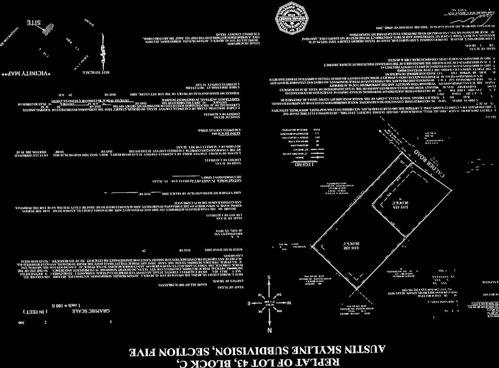


270

271
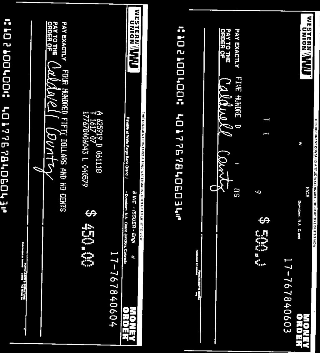
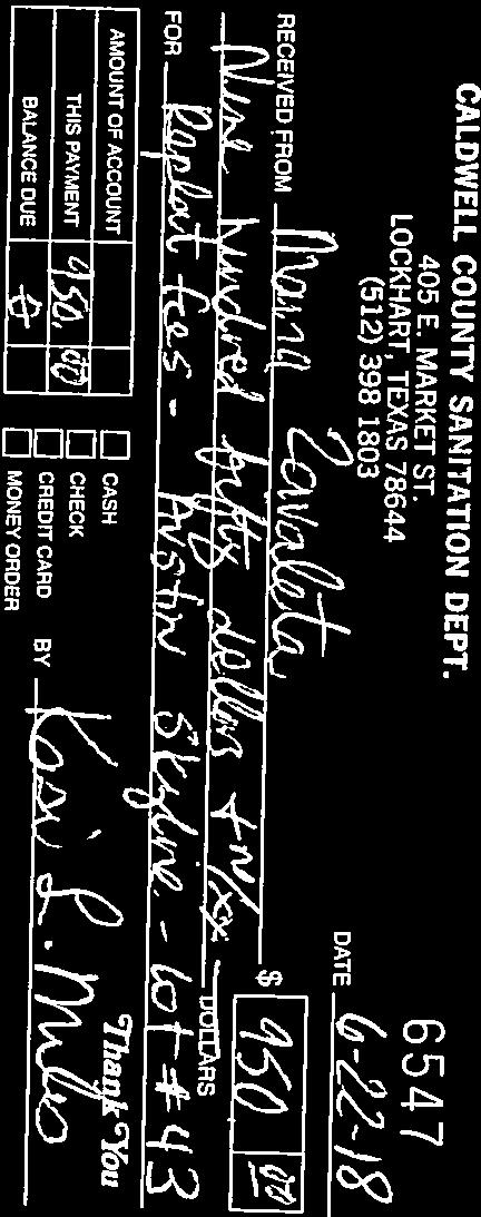

272
273


274

275
276


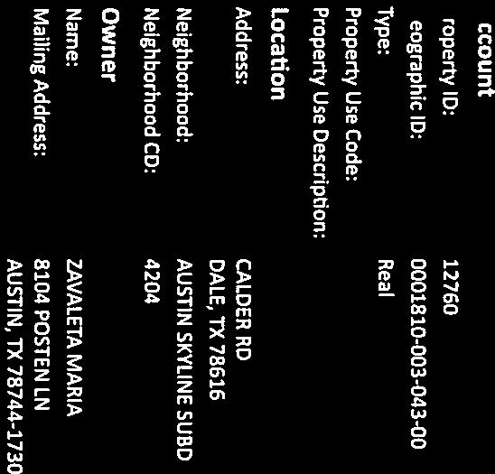


277
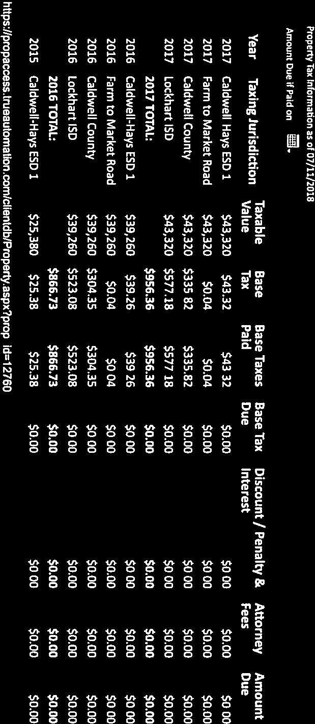
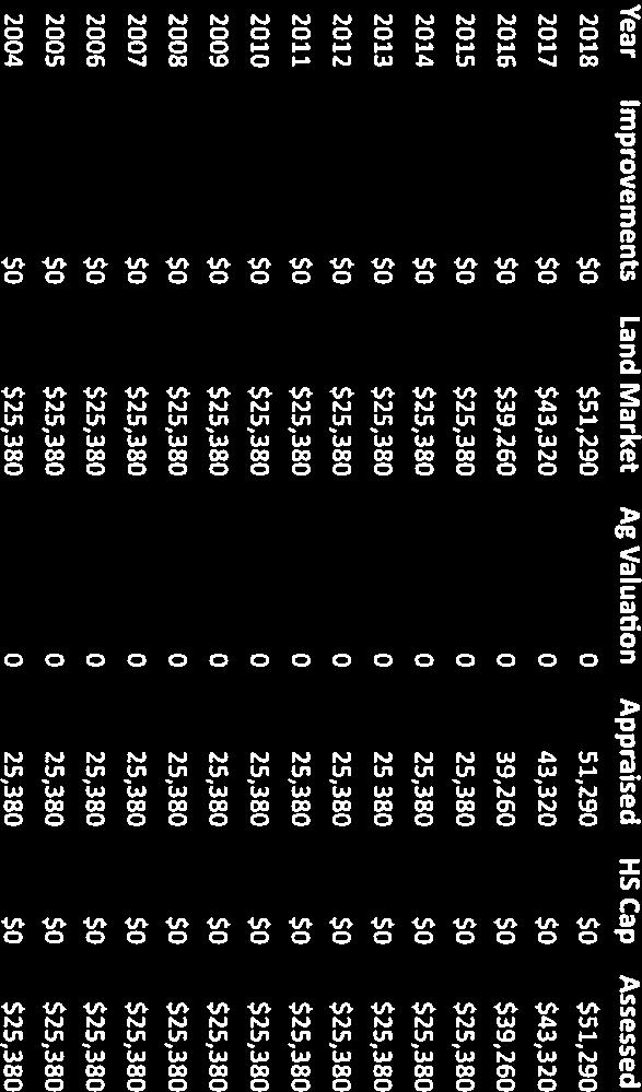


278
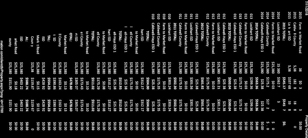
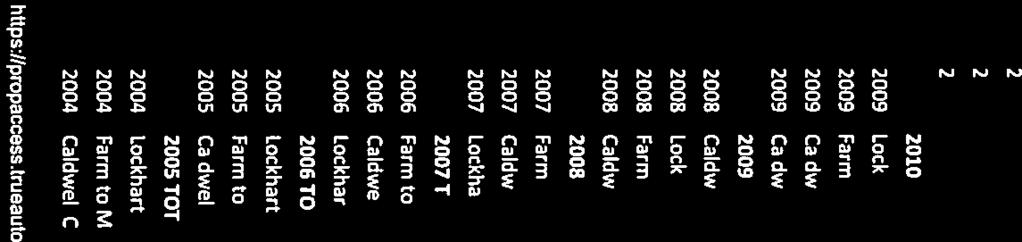

279
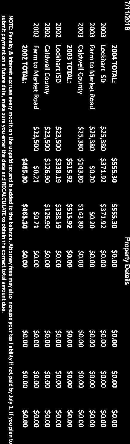
280


281
282 15. EXECUTIVE SESSION Pursuant to Sections , and of the Texas Government Code: consultation with counsel and deliberation regarding the County s Threat and Hazard Identification, Risk Assessment (THIRA); State Preparedness Report (SPR); security assessments related to information resources technologies; critical infrastructure; and general security audit. Possible action may follow in open court. Cost: None; Speaker: Judge Schawe / Martin Ritchey; Backup: None.
283 16. BUDGET WORKSHOP: Cost: None; Speaker: Judge Schawe; Backup: None.
284 17. Discussion/Action regarding notice of Elected Officials proposed salaries. Cost: TBD; Speaker: Judge Schawe; Backup: 1.

285
286 18. Discussion/Action regarding the renewal of the County Employee Health Benefits for Plan Year Cost: TBD; Speaker: Judge Schawe; Backup: 1.

287 Medical Plan Deductible (In/Out Network) Individual Family Coinsurance (In/Out Network) Co-Insurance Maximum Individual Family Office Visit (PCP) / Specialist Preventive Services Current Renewal Alternate 1 Alternate 2 Alternate 3 Alternate 4 TAC BCBSTX Plan 1300-NGS RX: 5C-NG TAC BCBSTX Plan 1300-NGS RX: 5C-NG TAC BCBSTX Plan 1400-NGS RX: 5C-NG TAC BCBSTX Plan 1500-NGS RX: 5C-NG TAC BCBSTX Plan 1500-NGS RX: 5B-NG TAC BCBSTX Plan 1520-NGS RX: 5B-NG $1500/$4500 $1500/$4500 $2000/$6000 $2500/$7500 $2500/$7500 $3000/$7500 $4500/$13500 $4500/$13500 $6000/$18000 $7500/$22500 $7500/$22500 $9000/$ %/60% 80%/60% 80%/60% 80%/60% 80%/60% 80%/60% $3500/$7000 $3500/$7000 $4000/$8000 $4350/$8000 $4350/$8000 $4150/$8000 $8700/$21000 $8700/$21000 $7200/$24000 $6200/$24,000 $6200/$24,000 $5300/$24000 $30/$40 copay $30/$40 copay $35/$45 copay $40/$50 copay $40/$50 copay $40/$50 copay covered at 100% covered at 100% covered at 100% covered at 100% covered at 100% covered at 100% Emergency Room (facility charges) $150 copay $150 copay $150 copay $150 copay $150 copay $150 copay Prescription Plan Deductible Prescription Co-Pay $250 copay $250 copay $250 copay $250 copay $100 copay $100 copay 10/30/50 10/30/50 10/30/50 10/30/50 10/30/50 10/30/50 Rate Tier Counts* Rates Rates Rates Rates Rates Rates Employee Only 177 $ $ $ $ $ $ Employee + Children 35 $1, $1, $1, $1, $1, $1, Employee + Spouse 8 $1, $1, $1, $1, $1, $1, Employee + Family 1 $1, $1, $1, $1, $1, $1, Total Count 221. Estimated Monthly Premium $173, $188, $179, $171, $177, $172, Estimated Annual Premium $2,076, $2,259, $2,150, $2,061, $2,125, $2,068, Estimated Annual Increase/Decrease Percentage Change Caldwell County - Plan Options (Non-Grandfathered) TEXAS ASSOCIATION OF COUNTIES HEBP - HEALTH BENEFIT OPTIONS Effective Date: 10/1/2018 $182, $74, ($14,642.64) $49, ($8,264.16) N/A 8.8% 3.59% -0.71% 2.36% -0.40% This is a brief overview of the benefit summary. For plan details, please refer to the actual summary of benefits highlight and/or the benefits booklet. *Counts based on June enrollment
CALDWELL COUNTY DEVELOPMENT ORDINANCE
 CALDWELL COUNTY DEVELOPMENT ORDINANCE Adopted January 18, 2011 TABLE OF CONTENTS 1.0 AUTHORITY... 1 1.1 COORDINATION WITH OTHER JURISDICTIONS... 2 1.2 ENFORCEMENT AND PENALTIES... 2 1.3 AUTHORITY OF THE
TEXAS SMALL LAND SALES REPORT Edition
 TEXAS SMALL LAND SALES REPORT 2017 Edition ABOUT THE TEXAS SMALL LAND SALES REPORT The Texas Small Land Sales Report analyzes small land sales data and trends across seven regions of Texas utilizing survey
Announced Activity as of September 23
 Anderson WB0TEV/M W3DYA/M Andrews N5NA/M KD5HCV/M Angelina W3DYA/M Aransas N5TM/M K5END/M Archer N4CD/M Armstrong K5MRA/M W0BH/M Atascosa K5END/M Austin KK5W/M N5TM/M K5END/M K5AWC KU5B/M Bailey W5ETJ/M
Budget, Finance & Audit Committee Meeting Monday, February 22,2010,9:30-11:30 a.m Marilla Street, City Half, Room 6ES, Dallas, Texas 75201
 Memorandum CITY OF DALLAS DATE: February 18,2010 TO: SUBJECT: Members of the Budget, Finance & Audit Committee Ann Margolin, Vice Chair, Vonciel Jones Hill, Angela Hunt, Delia D. Jasso, Ron Natinsky, David
State Tackles Appraisal Inconsistencies. PUBLICATION 2032 A Reprint from Tierra Grande magazine Real Estate Center. All rights reserved.
 JULY 2013 Appraisal PUBLICATION 2032 A Reprint from Tierra Grande magazine 2013. Real Estate Center. All rights reserved. State Tackles Appraisal Inconsistencies By Charles E. Gilliland and Michael Oberrender
13-2 SUBDIVISION PLANS AND PLATS REQUIRED EXCEPTIONS Subdivision Plats Required To be Recorded
 ARTICLE XIII SUBDIVISIONS 13-1 INTENT AND PURPOSE 13-1-1 Intent: It is the intent of the County Commission through the adoption of this Article to more fully avail itself of the power granted under 17-27-601
SUBDIVISION REGULATIONS McLennan County, Texas
 SUBDIVISION REGULATIONS McLennan County, Texas SUBDIVISION REGULATIONS McLennan County, Texas TABLE OF CONTENTS Article I... 1 Purpose and Authority... 1 Section 1.1 Purpose... 1 Section 1.2 Findings...
I. Requirements for All Applications. C D W
 108-16.1. Application checklists. Checklist for Required Submissions to the Planning Board or Zoning Board of Adjustment of Monroe Township All required submissions are to be made to the Administrative
TLTA Directory Listings Requiring Updates As of 2/26/2015 Company Name City Licensed Counties A-1 Abstract & Title Co. Muleshoe Bailey Lamb Adams
 A-1 Abstract & Title Co. Muleshoe Bailey Lamb Adams Abstract Company, Inc. Robert Lee Coke Alamo Title Company Colleyville Ellis All Texas Title, Inc. Sealy Austin American Guaranty Title, L.L.C. Waco
WAYNE COUNTY, UTAH SUBDIVISION ORDINANCE
 WAYNE COUNTY, UTAH SUBDIVISION ORDINANCE A LAND USE ORDINANCE OF WAYNE COUNTY As Adopted by the Wayne County Board of County Commissioners Effective January 01, 2011 Prepared by: PLANNING AND DEVELOPMENT
CHAPTER 3 PRELIMINARY PLAT
 10-3-1 10-3-3 SECTION: CHAPTER 3 PRELIMINARY PLAT 10-3-1: Consultation 10-3-2: Filing 10-3-3: Requirements 10-3-4: Approval 10-3-5: Time Limitation 10-3-6: Grading Limitation 10-3-1: CONSULTATION: Each
FREQUENTLY USED PLANNING & ZONING TERMS
 City Of Mustang FREQUENTLY USED PLANNING & ZONING TERMS Abut: Having property lines, street lines, or zoning district lines in common. Accessory Structure: A structure of secondary importance or function
SUBDIVISION REGULATIONS
 CHAPTER 14 SUBDIVISION REGULATIONS 14-100 Provisions 14-200 Preliminary Plat 14-300 Final Plat 14-400 Replat 14-500 Minor Subdivision 14-600 Administrative Replat 14-700 Vacation of Roadways, Public Easements,
201 General Provisions
 201 General Provisions 201.01 Title 201.09 Amendments 201.02 Purpose and Intent 201.10 Public Purpose 201.03 Authority 201.11 Variances and Appeals 201.04 Jurisdiction 201.12 Nonconformances 201.05 Enactment
This Ordinance is adopted under the authority and provisions of the General Statutes of North Carolina, Article 6, Chapter 153A 121.
 Section 74, Regulations Governing Manufactured Home Parks 1. Purpose The purpose of these regulations to be known and cited as the Madison County Manufactured Home Park Ordinance is to regulate and guide
SECTION 7000 LAND DEVELOPMENT REQUIREMENTS
 SECTION 7000 LAND DEVELOPMENT REQUIREMENTS 7000 LAND DEVELOPMENT REQUIREMENTS... 1 7001 LEGISLATIVE AUTHORITY... 1 7001.1 LAND DEVELOPMENT... 1 7001.1.1 Title 40, Idaho Code... 1 7001.1.2 Idaho Code 40-1415
State Law reference Extraterritorial jurisdiction, V.T.C.A., Local Government Code et seq.
 ARTICLE I. - IN GENERAL Sec. 126-1. - Definitions. The following words, terms and phrases, when used in this chapter, shall have the meanings ascribed to them in this section, except where the context
ARTICLE 100 SUBDIVISION APPLICATION PROCEDURE AND APPROVAL PROCESS
 ARTICLE 100 SUBDIVISION APPLICATION PROCEDURE AND APPROVAL PROCESS 100.01 General Procedure 100.02 Exempt Subdivision 100.03 Administrative Subdivision 100.04 Major Subdivision 100.05 Signing and Recording
INFRASTRUCTURE DEVELOPMENT REGULATIONS FOR MANUFACTURED HOME RENTAL COMMUNITIES McLennan County, Texas
 INFRASTRUCTURE DEVELOPMENT REGULATIONS FOR MANUFACTURED HOME RENTAL COMMUNITIES McLennan County, Texas INFRASTRUCTURE DEVELOPMENT REGULATIONS FOR MANUFACTURED HOME RENTAL COMMUNITIES McLennan County, Texas
Appendix A. Definitions
 Definitions 1. Terms Defined. Words contained in this are those having a special meaning relative to the purposes of this Ordinance. Words not listed in this section shall be defined by reference to: (1)
ARTICLE 15. RULES, REGULATIONS AND DEFINITIONS
 ARTICLE 15. RULES, REGULATIONS AND DEFINITIONS Section 1. Interpretation and Construction: The following rules and regulations regarding interpretation and construction of the Ulysses-Grant County, Kansas,
-MENDOCINO COUNTY PLANNING AND BUILDING SERVICES- DIVISION OF LAND REGULATIONS TITLE 17
 ARTICLE VI -- GENERAL REGULATIONS AND PROVISIONS Sec. 17-50. Sec. 17-51 General Plan. Sec. 17-52 Lot and Block Design and Configuration. Sec. 17-53 Lot Access. Sec. 17-54 Private Roads. Sec. 17-55 Water
LAND DEVELOPMENT AND SUBDIVISION ORDINANCE
 LAND DEVELOPMENT AND SUBDIVISION ORDINANCE (CHAPTER 18 OF THE MUNICIPAL CODE OF ORDINANCES) TO BE IMPLEMENTED BY: THE CITY OF FLORENCE July 2007 TABLE OF CONTENTS ARTICLE I: IN GENERAL... 1 1.1 Title...
Town of Lisbon, Maine SUBDIVISION REVIEW APPLICATION
 Date Received: Fee Paid (amount): Applicant: Town of Lisbon, Maine SUBDIVISION REVIEW APPLICATION Subdivision Name/Title: This application must be received at the Town Office by close of business on the
MASTER SUBDIVISION FINAL PLAT APPLICATION Town of Apex, North Carolina
 MASTER SUBDIVISION FINAL PLAT APPLICATION Town of Apex, North Carolina This document is a public record under the North Carolina Public Records Act and may be published to the Town s website or disclosed
CHAPTER 14: DRIVEWAYS, TOWN HIGHWAYS, AND PRIVATE ROADS
 CHAPTER 14: DRIVEWAYS, TOWN HIGHWAYS, AND PRIVATE ROADS TABLE OF CONTENTS CHAPTER 14: PRIVATE DRIVEWAYS, TOWN HIGHWAYS AND PRIVATE ROADS 14-1 14.0100 AUTHORITY... 14-1 14.0200 TITLE... 14-1 14.0300 REGULATION
ARTICLE III GENERAL PROCEDURES, MINOR PLANS AND FEE SCHEDULES
 ARTICLE III GENERAL PROCEDURES, MINOR PLANS AND FEE SCHEDULES 301. Prior to Submission a. Copies of this Ordinance shall be available on request, at cost, for the use of any person who desires information
New Private Way Ordinance Westbrook Planning Board Workshop , Planning Board Public Hearing Definitions
 201 Definitions Private Right of Way; Private way A strip of land at least fifty feet wide, meeting the minimum standards for the construction of a gravel base for a public road, over which abutters may
ARTICLE IV: DEVELOPMENT STANDARDS
 ARTICLE IV: DEVELOPMENT STANDARDS IV-53 409 PRIVATE STREETS A private street means any way that provides ingress to, or egress from, property by means of vehicles or other means, or that provides travel
RULES, REGULATIONS AND REQUIREMENTS RELATING TO THE APPROVAL AND ACCEPTANCE OF IMPROVEMENTS IN SUBDIVISIONS OR RE-SUBDIVISIONS
 GALVESTON COUNTY RULES, REGULATIONS AND REQUIREMENTS RELATING TO THE APPROVAL AND ACCEPTANCE OF IMPROVEMENTS IN SUBDIVISIONS OR RE-SUBDIVISIONS GALVESTON COUNTY ENGINEERING DEPARTMENT MARCH 3, 1997 Amendment
Chapter 100 Planned Unit Development in Corvallis Urban Fringe
 100.100 Scope and Purpose. Chapter 100 Planned Unit Development in Corvallis Urban Fringe (1) All applications for land divisions in the Urban Residential (UR) and Flood Plain Agriculture (FPA) zones within
E L M E R B O R O U G H L A N D U S E B O A R D APPLICATION COVER SHEET (to be completed for all applications and appeals)
") E L M E R B O R O U G H L A N D U S E B O A R D APPLICATION COVER SHEET (to be completed for all applications and appeals) 1. Name(s): 2. Address: 3. Telephone Number(s): 4. E-mail: 5. Owner Name(s) (if
E L M E R B O R O U G H L A N D U S E B O A R D APPLICATION COVER SHEET (to be completed for all applications and appeals) 1. Name(s): 2. Address: 3. Telephone Number(s): 4. E-mail: 5. Owner Name(s) (if
ANDREWS COUNTY, TEXAS. Subdivision Regulations Approved By Commissioners June 16, 2014
 ANDREWS COUNTY, TEXAS Subdivision Regulations Approved By Commissioners June 16, 2014 Court ANDREWS COUNTY SUBDIVISION REGULATIONS TABLE OF CONTENTS ARTICLE 1. INTRODUCTION Preamble and Purpose 4 General
MINOR SUBDIVISION FINAL PLAT APPLICATION Town of Apex, North Carolina
 MINOR SUBDIVISION FINAL PLAT APPLICATION Town of Apex, North Carolina This document is a public record under the North Carolina Public Records Act and may be published on the Town s website or disclosed
BEAR CREEK TOWNSHIP EMMET COUNTY, MICHIGAN. PRIVATE ROAD ORDINANCE Ordinance No. 11A-99. (to replace prior Private Road Ordinance No.
 BEAR CREEK TOWNSHIP EMMET COUNTY, MICHIGAN PRIVATE ROAD ORDINANCE Ordinance No. 11A-99 (to replace prior Private Road Ordinance No. 11-99) An Ordinance to protect the health, safety, and general welfare
SUBDIVISION APPLICATION
 SUBDIVISION APPLICATION Preliminary Plat Minor Plat Final Plat Amended Plat Applicant Name: Owner (if different from applicant) Name: Company: Company: Address: Address: City, State, Zip City, State, Zip
TOWN OF WATERVILLE VALLEY NEW HAMPSHIRE SITE PLAN REVIEW REGULATIONS
 TOWN OF WATERVILLE VALLEY NEW HAMPSHIRE Effective date March 17, 1981 Revised March 16, 1982 Revised March 13, 1986 Revised March 10, 1987 Revised March 14, 2013 Revised March 8, 2016 TOWN OF WATERVILLE
SUBDIVISION, PLANNING APPROVAL, & REZONING STAFF REPORT Date: June 4, 2015
 SUBDIVISION, PLANNING APPROVAL, & REZONING STAFF REPORT Date: June 4, 2015 APPLICANT NAME SUBDIVISION NAME DEVELOPMENT NAME LOCATION Board of Water & Sewer Commissioners of the City of Mobile MAWSS MLK
TOWNSHIP OF BORDENTOWN LAND DEVELOPMENT APPLICATION CHECKLIST. General Requirements for all Applications
 TOWNSHIP OF BORDENTOWN LAND DEVELOPMENT APPLICATION CHECKLIST This CHECKLIST has been adopted in accordance with Section 25:807 of the Land Development Ordinance of the Township of Bordentown and will
Condominium Unit Requirements.
 ARTICLE 19 CONDOMINIUM REGULATIONS Section 19.01 Purpose. The purpose of this Article is to regulate projects that divide real property under a contractual arrangement known as a condominium. New and conversion
MINOR SUBDIVISION INFORMATION
 A. POINTS OF CONTACT: MINOR SUBDIVISION INFORMATION Surveyor: Address: Phone #: Fax # E-Mail Address: Representative (If different from applicant): Address: Phone #: Fax # E-Mail Address: B. GENERAL INFORMATION:
COLLIN COUNTY SUBDIVISION REGULATIONS. Department of Engineering
 COLLIN COUNTY SUBDIVISION REGULATIONS Department of Engineering Updated: November 5, 2012 1 TABLE OF CONTENTS DEFINITIONS... 4 SECTION I - PRELIMINARY PLAT... 7 A. SUBDIVISION NAME AND STREET NAMES...
APPLICATION PROCEDURE
 ANTRIM PLANNING BOARD P. O. Box 517 Antrim, New Hampshire 03440 Phone: 603-588-6785 FAX: 603-588-2969 APPLICATION FORM AND CHECKLIST FOR MINOR OR MAJOR SITE PLAN REVIEW File Date Received By APPLICATION
CONDOMINIUM REGULATIONS
 ARTICLE 37 CONDOMINIUM REGULATIONS SECTION 37.01. Purpose The purpose of this Article is to regulate projects that divide real property under a contractual arrangement known as a condominium. New and conversion
SUBDIVISION CONTROL, PLATTING OF LANDS, AND LAND DIVISION
 SUBDIVISION CONTROL, PLATTING OF LANDS, AND LAND DIVISION Section I. Title/Purpose. This Ordinance is entitled Subdivision Control and Platting of Lands. The purpose of this Ordinance is as follows: To
SITE PLAN REVIEW ADMINISTRATIVE REVIEW. Please Note: Once submitted to the County, all application materials become a matter of public record.
 200 W. Oak Street, 3rd Floor Fort Collins, CO 80521 (970) 498-7683 / larimer.org/planning SITE PLAN REVIEW ADMINISTRATIVE REVIEW The submittal requirements listed in this packet are intended to collect
Village of South Elgin, IL. CHAPTER 156: Unified Development Ordinance
 Village of South Elgin, IL CHAPTER 156: Unified Development Ordinance UNIFIED DEVELOPMENT ORDINANCE (UDO) EFFECTIVE DATE: October 1, 2018 1 TABLE OF CONTENTS SECTION 156.01: TITLE AND APPLICABILITY...4
MAJOR SUBDIVISION PRELIMINARY PLAT CHECKLIST
 TOWNSHIP OF EGG HARBOR PLANNING BOARD/ZONING BOARD OF ADJUSTMENT 3515 BARGAINTOWN ROAD EGG HARBOR TOWNSHIP, NJ 08234 MAJOR SUBDIVISION PRELIMINARY PLAT CHECKLIST The following checklist is designed to
JACKSON COUNTY DEVELOPMENT RULES, REGULATIONS AND PROTOCOLS Non-Commercial Structures
 JACKSON COUNTY DEVELOPMENT RULES, REGULATIONS AND PROTOCOLS Non-Commercial Structures Mission Statement: We are first a public agency, funded by public tax dollars. Our fundamental mission is to protect
Preliminary Plat Application & Submittal Checklist
 Planning & Community Development Department 550 Landa Street New Braunfels, Texas 78130 (830) 221-4050 www.nbtexas.org Preliminary Plat Application & Submittal Checklist Applicant Name: *Signature. * By
CITY OF SARALAND PRELIMINARY SUBDIVISION PLAT REVIEW
 PRELIMINARY SUBDIVISION PLAT REVIEW Application Number: Date Plat Submitted: Name of Subdivision: Name of Owner: Owner Address: (Street or P.O. Box) Telephone #: (City) (State) (Zip) E-mail: Name of Authorized
STATE OF MICHIGAN COUNTY OF MARQUETTE, TOWNSHIP OF NEGAUNEE LAND DIVISION, SUBDIVISION AND CONDOMINIUM ORDINANCE
 STATE OF MICHIGAN COUNTY OF MARQUETTE, TOWNSHIP OF NEGAUNEE LAND DIVISION, SUBDIVISION AND CONDOMINIUM ORDINANCE Adopted: August 8 th, 2008 Effective: August 28 th, 2008 Sec.100. Title ARTICLE I GENERAL
APPLICATION FOR 555 Washington Street Tentative Map Red Bluff, CA Subdivision Map (530) ext Parcel Map.
 ext Parcel Map.") City of Red Bluff Community Development Department Application No. APPLICATION FOR 555 Washington Street Tentative Map Red Bluff, CA 96080 Subdivision Map (530) 527-2605 ext. 3059 Parcel Map Applicant
City of Red Bluff Community Development Department Application No. APPLICATION FOR 555 Washington Street Tentative Map Red Bluff, CA 96080 Subdivision Map (530) 527-2605 ext. 3059 Parcel Map Applicant
CHAPTER XVIII SITE PLAN REVIEW
 CHAPTER XVIII SITE PLAN REVIEW Section 18.1 Section 18.2 Description and Purpose. The purpose of this chapter is to provide standards and procedures under which applicants would submit, and the Township
CHAPTER 18 SUBDIVISION AND PLATTING ORDINANCE OF THE TOWN OF OSCEOLA CODE OF ORDINANCES
 TOWN OF OSCEOLA POLK COUNTY WISCONSIN ORDINANCE # 18-03-03 CHAPTER 18 SUBDIVISION AND PLATTING ORDINANCE OF THE TOWN OF OSCEOLA CODE OF ORDINANCES 18.01 Purpose Adopted 3/08/99, Amended 5/12/03, 7/9/07,
CITY OF SARALAND FINAL SUBDIVISION PLAT REVIEW
 CITY OF SARALAND FINAL SUBDIVISION PLAT REVIEW Application Number: Date Plat Submitted: Name of Subdivision: Name of Owner: Owner Address: (Street or P.O. Box) Telephone #: (City) (State) (Zip) E-mail:
TITLE 25. SUBDIVISIONS 1
 TITLE 25. SUBDIVISIONS 1 Sections: Chapter 25.01 General Provisions. Section 25.01.01 Short Title. Section 25.01.02 Purposes. Section 25.01.03 Final Plat Required Before Lots May be Sold. Section 25.01.04
Town of Prairie du Sac Sauk County, WI. Land Division Ordinance 07-3
 Town of Prairie du Sac Sauk County, WI Land Division Ordinance 07-3 1.01 DISCLAIMER (1) Multiple Jurisdictions. All persons reviewing the provisions of this Ordinance should be aware that the Town of Prairie
ARTICLE 5 MINOR SUBDIVISION/LAND DEVELOPMENT
 ARTICLE 5 MINOR SUBDIVISION/LAND DEVELOPMENT SECTION 501 ONLY FINAL PLAN REQUIRED The classification of a proposed subdivision as a "Minor Subdivision" shall only require the submission, review and approval
ARTICLE 3 DEFINITIONS
 Sections: 3-1 Rules of Construction 3-2 Definitions ARTICLE 3 DEFINITIONS SECTION 3-1 RULES OF CONSTRUCTION 3-101. a. The language set forth in these regulations shall be interpreted in accordance with
DENTON Developer's Handbook
 DENTON Developer's Handbook A guide for land development in the City of Denton Department of Development Services 2017 2 Table of Contents 1. City of Denton Development Process...5 Role of the Development
610 LAND DIVISIONS AND PROPERTY LINE ADJUSTMENTS OUTSIDE A UGB
 ARTICLE VI: LAND DIVISIONS AND PROPERTY LINE ADJUSTMENTS VI-21 610 LAND DIVISIONS AND PROPERTY LINE ADJUSTMENTS OUTSIDE A UGB 610-1 Property Line Adjustments (Property Line Relocation) A property line
BY THE CITY COMMISSION ORDINANCE NO.:
 BY THE CITY COMMISSION ORDINANCE NO.: 2005-0868 AN ORDINANCE BY THE CITY COMMISSION OF THE CITY OF DADE CITY, FLORIDA CREATING A DEVELOPMENT REVIEW PROCEDURES ORDINANCE; PROVIDING FOR INTENT, PURPOSE,
FINAL SITE PLAN PLAT APPLICATION Town of Apex, North Carolina
 FINAL SITE PLAN PLAT APPLICATION Town of Apex, North Carolina This document is a public record under the North Carolina Public Records Act and may be published on the Town s website or disclosed to third
MAJOR RESIDENTIAL AND NONRESIDENTIAL SUBDIVISIONS
 Lawrence-Douglas County MAJOR RESIDENTIAL AND NONRESIDENTIAL SUBDIVISIONS Preliminary Plats The applicant shall schedule a Pre-Application meeting with Planning Staff at least seven (7) working days prior
MINOR SUBDIVISION PLAT CHECKLIST
 MINOR SUBDIVISION PLAT CHECKLIST Project Name: Tax ID #: Project Number: Date: _ Reviewed By: Telephone: NOTES: All lots on septic systems must comply with the Fulton County Health Department requirements
BOARD OF COUNTY COMMISSIONERS ARCHULETA COUNTY, COLORADO RESOLUTION 2018-
 BOARD OF COUNTY COMMISSIONERS ARCHULETA COUNTY, COLORADO RESOLUTION 2018- ARCHULETA COUNTY IMPROPERLY DIVIDED PARCELS EXEMPTION INTERIM RESOLUTION - A RESOLUTION ADDRESSING PARCELS UNDER THE SIZE OF 35
Town of Bristol Rhode Island
 Town of Bristol Rhode Island Subdivision & Development Review Regulations Adopted by the Planning Board September 27, 1995 (March 2017) Formatted: Highlight Formatted: Font: 12 pt Table of Contents TABLE
LAND USE APPLICATION
 LAND USE APPLICATION File Name: File No(s).: Receipt No.: Receipt Date: Received By: Amount.: $ Instructions for Applicants Please read and follow all instructions on your application carefully. If you
WASHINGTON COUNTY CUP SUBMITTAL CHECKLIST
 WASHINGTON COUNTY CUP SUBMITTAL CHECKLIST The following must be turned in to the Planning Office by the submittal date for your CUP to be reviewed by the Planning Board. (Incomplete applications will not
ORDINANCE NO. Be it ordained by the City Council of the City of Abilene, Texas:
 ORDINANCE NO. An ordinance repealing Chapter 23, Subpart B of the Code of the City of Abilene, Texas, entitled Mobile Homes and Vacation Travel Trailers; stating the authority; setting forth the scope
Article 2 Application Type and Standards Requirements
 Article 1 Article 2 Division 1 Application Type and Standards Requirements General Provisions Sec. 2.1.1 Division 2 Division 3 Division 4 Division 5 Division 6 Division 7 Division 8 Division 9 Sec. 2.9.1
BELL COUNTY INFRASTRUCTURE REQUIREMENTS FOR MANUFACTURED HOME RENTAL COMMUNITIES
 BELL COUNTY INFRASTRUCTURE REQUIREMENTS FOR MANUFACTURED HOME RENTAL COMMUNITIES 1. Definitions: a. Manufactured Home-Means a structure falling within the definition of manufactured housing in Art. 5221f,
Ferry County Ordinance #89-04 BINDING SITE PLAN ORDINANCE
 Ferry County Ordinance #89-04 BINDING SITE PLAN ORDINANCE AN ORDINANCE providing for an alternate method of subdividing property for the purpose of allowing tracts of land having more than one residence
Draft Model Access Management Overlay Ordinance
 Draft Model Access Management Overlay Ordinance This model was developed using the City of Hutchinson and the Trunk Highway 7 corridor. The basic provisions of this model may be adopted by any jurisdiction
IV. REVIEW PROCEDURES FOR MINOR SUBDIVISIONS
 IV. REVIEW PROCEDURES FOR MINOR SUBDIVISIONS IV-A. General Minor subdivisions create five or fewer lots from a tract of record, each lot of which has legal and physical access. If the tract of record proposed
PALO PINTO COUNTY Subdivision Regulations
 PALO PINTO COUNTY Subdivision Regulations APPROVED BY THE PALO PINTO COUNTY COMMISSIONER S COURT September 26, 2014 PALO PINTO COUNTY Subdivision Regulations TABLE OF CONTENTS ARTICLE 1. GENERAL PROVISIONS...
FINAL PLAT SUBMITTAL CHECKLIST
 FINAL PLAT SUBMITTAL CHECKLIST The submission requirements for a Final Plat Review are found beginning in Section 24-4-40 of the Weld County Code. The Weld County Code is available on line at www.co.weld.co.us
FINAL PLAT CHECKLIST
 FINAL PLAT CHECKLIST Project Name: Tax ID #: Project Number: Date: _ Reviewed By: Telephone: Please address all items marked with an "X" Please return redline comments with corrected plan, original mylar,
Change 6, September 1, TITLE 18 WATER AND SEWERS 1
 Change 6, September 1, 2011 18-1 TITLE 18 WATER AND SEWERS 1 CHAPTER 1. MISCELLANEOUS. 2. CITY WASTEWATER SYSTEM. 3. WASTEWATER TREATMENT (SEWER) SYSTEM. 4. WATER. 5. CONNECTIONS WITH PUBLIC WATER SUPPLY.
^divisions are to be surveyed and platted by a Registered(5urveyor/or
 upsnur UPSHUR COUNTY CLERK Home Subdivision Plats... Introduction To Subdivision Piats H A subdivision is the division of any lot, tract, or parcel of land into two or more lots or sites for the purpose
CITY OF TIFFIN IOWA SUBDIVISION ORDINANCE NO
 CITY OF TIFFIN IOWA SUBDIVISION ORDINANCE NO. 1998-218 Other Applicable Ordinances: No. 2006-278 RECOUPMENT FEES ORD 2012-319 Amending Provisions Relating To Subdivisons EDITS by Planning and Zoning 2012.
REGULAR FINAL PLAT SUBDIVISION APPLICATION
 REGULAR FINAL PLAT SUBDIVISION APPLICATION Name of Subdivision (Subdivision Name must be approved by at 856-6216) ( )Cluster Subdivision ( )Lot-by-Lot Subdivision ( )Open Space Subdivision Name of Subdivision
Ordinance No. An Amendment to the City Code of Ordinances
 Ordinance No. An Amendment to the City Code of Ordinances CHAPTER AND PURPOSE. Chapter 74, Utilities, Article IV, Stormwater Management. ENACTING CLAUSE. The Council of the City of Norcross, Georgia hereby
City of Shenandoah Development Package
 Upon completion return application to Development@shenandoahtx.us City of Shenandoah Development Package Documentation includes the following: Fee Schedule Platting Development Check List & Outline Development
PONDS. A. Definitions.
 A. Definitions. PONDS For purposes of this section, the following terms shall have the following meanings: 1. Application means all documents, forms and other information that the Department may require
KASSON TOWNSHIP PRIVATE ACCESS ROAD ORDINANCE ORDINANCE NO (EFFECTIVE: MAY 12, 2007)
") KASSON TOWNSHIP PRIVATE ACCESS ROAD ORDINANCE ORDINANCE NO. 2007-01 (EFFECTIVE: MAY 12, 2007) An ordinance providing for the standards and specifications incident to the development of Private Motor Vehicle
KASSON TOWNSHIP PRIVATE ACCESS ROAD ORDINANCE ORDINANCE NO. 2007-01 (EFFECTIVE: MAY 12, 2007) An ordinance providing for the standards and specifications incident to the development of Private Motor Vehicle
THE COUNTY BOARD OF SUPERVISORS OF THE COUNTY OF DOUGLAS DOES ORDAIN AS FOLLOWS:
 8.1 SUBDIVISION CONTROL ORDINANCE THE COUNTY BOARD OF SUPERVISORS OF THE COUNTY OF DOUGLAS DOES ORDAIN AS FOLLOWS: SECTION I. GENERAL INTERPRETATION This ordinance shall not repeal, impair or modify private
ARTICLE 15 - PLANNED UNIT DEVELOPMENT
 Section 15.1 - Intent. ARTICLE 15 - PLANNED UNIT DEVELOPMENT A PUD, or Planned Unit Development, is not a District per se, but rather a set of standards that may be applied to a development type. The Planned
BACKGROUND There are 23 flood control structures in the Upper Brushy Creek Water Control and Improvement District (District). See attached map.
. See attached map.") BACKGROUND There are 23 flood control structures in the Upper Brushy Creek Water Control and Improvement District (District). See attached map. The U.S Department of Agriculture - Natural Resources Conservation
BACKGROUND There are 23 flood control structures in the Upper Brushy Creek Water Control and Improvement District (District). See attached map. The U.S Department of Agriculture - Natural Resources Conservation
KLICKITAT COUNTY CODE Chapter RECREATIONAL VEHICLE PARKS
 KLICKITAT COUNTY CODE Chapter 22.08 - RECREATIONAL VEHICLE PARKS 22.08.010 - Applicability. Every recreational park in the unincorporated area of the county shall be located, constructed, altered, expanded
Preliminary Subdivision Application (Minor) (Three (3) lots or less)
 (Three (3) lots or less)") Gunnison City Offices www.gunnisoncity.org 38 West Center Gunnison, Utah 84634 (435) 528 7969 Date of Application: Preliminary Subdivision Application (Minor) (Three (3) lots or less) APPLICANT INFORMATION
Gunnison City Offices www.gunnisoncity.org 38 West Center Gunnison, Utah 84634 (435) 528 7969 Date of Application: Preliminary Subdivision Application (Minor) (Three (3) lots or less) APPLICANT INFORMATION
UPPER MOUNT BETHEL TOWNSHIP NORTHAMPTON COUNTY, PENNSYLVANIA
 UPPER MOUNT BETHEL TOWNSHIP NORTHAMPTON COUNTY, PENNSYLVANIA JOINDER DEED / LOT CONSOLIDATION TOWNSHIP REVIEW PROCESS When accepting proposed Joinder Deeds / Lot Consolidations, review the Joinder Deed
TABLE OF CONTENTS. PAGE ARTICLE I. 1. Preamble and Purposes ARTICLE II. 2. Definitions.. 4
 TABLE OF CONTENTS PAGE ARTICLE I. 1. Preamble and Purposes...... 1 ARTICLE II. 2. Definitions.. 4 ARTICLE III. 3. General Subdivision Requirements 8 3.1 General Requirements 8 3.2 Subdivision Approval
Memorandum: October 13, 2008 REVISED To: Trowbridge Township Planning Commission From: P. Hudson, AICP Re: Suggested New Ordinance
 1 Memorandum: October 13, 2008 REVISED 2-11-09 To: Trowbridge Township Planning Commission From: P. Hudson, AICP Re: Suggested New Ordinance Because of changes in both the Michigan Planning Enabling Act
Guide to Minor Developments
 Guide to Minor Developments Introduction The Douglas County (DCD) is committed to providing open, transparent application processes to the public. This Guide is provided to assist anyone interested in
STORMWATER MANAGEMENT SYSTEM AND FACILITIES
 152.01 Purpose 152.09 Nonresidential Unit 152.02 Findings 152.10 Rate Determinations; Compliance with Bond 152.03 Scope and Responsibility for Stormwater Utility Covenants 152.04 Definitions 152.11 Billing,
Plans shall be drawn at a readable scale, signed, and sealed by a Florida Registered Engineer. The application package shall include:
 CHAPTER 400. SECTION 403. PERMIT TYPES AND APPLICATIONS SITE DEVELOPMENT 403.3. Preliminary Site Plans (PSP) A. Intent and Purpose PSPs are used to identify existing site conditions and demonstrate general
ARTICLE V PRELIMINARY PLAN SUBMISSION
 ARTICLE V PRELIMINARY PLAN SUBMISSION 501. Plan Requirements a. On or before the 25 th day of the month prior to a regularly scheduled meeting of the Planning Commission, the applicant shall submit two
Extractive Industrial Regulatory Ordinance No. 21 revised Dec. 28, 2010 EXTRACTIVE INDUSTRIAL REGULATORY ORDINANCE TYRONE TOWNSHIP, MICHIGAN
 40.101 Sec. 1. TITLE. EXTRACTIVE INDUSTRIAL REGULATORY ORDINANCE TYRONE TOWNSHIP, MICHIGAN ord. no. 21 eff. May 12, 1979, revised Dec. 28, 2010 This ordinance shall be known and cited as the Tyrone Township