Planning Commission Work Meeting Minutes Thursday, January 17, 2019 City Council Chambers 220 East Morris Avenue Time 6:30 p.m.
|
|
|
- Gary Blake
- 5 years ago
- Views:
Transcription
1 Planning Commission Work Meeting Minutes Thursday, January 17, 2019 City Council Chambers 220 East Morris Avenue Time 6:30 p.m. Commission Members Present: Staff Members Present: Laura Vernon, Chair Jeremy Carter Susan Dickstein Stacey Holscher George Pechmann Chad Ewell LeAnne Huff Alexandra White, Planning Manager Jeff Attermann, City Planner Hannah Vickery, City Attorney 1. Discussion of Agenda Items. City Planner, Jeff Attermann, presented the staff report for a request for final plat approval of a fourlot consolidation at 3839 South West Temple. The purpose of the consolidation was to prepare the property for redevelopment. The project size would be acres after consolidation. The applicant intended to build three, five-story buildings with 287 apartment units and two commercial units fronting 3900 South. Parking would be behind the development in the center of the block. Points of access would be on 3900 South, West Temple, and Main Street. Mr. Attermann displayed an image depicting the existing easements on the property and stated that the one in green would disappear with the consolidation of the four lots. Staff recommended approval of the application. City Attorney, Hannah Vickery, noted that the owner of Left Fork Grill would have to sign the final plat. Planning Manager, Alexandra White, presented the staff report for the third item on the agenda and said that it was a three-part application. The first part of the petition was for an amendment to the Future Land Use Map of the General Plan, changing the designation of the property from General Commercial to High-Density Residential 16 to 29 Units Per Acre. The second part was a petition to amend the South Salt Lake Municipal Code to allow for a land use district specific to the property, which would be called Granite Flats Multi-Family Townhome (GFT) Zone. The last part of the application was a subdivision plat for a 27-townhome development. The property was located at 441 East 3900 South and was 1.69 acres in size. The density of the project would be about 17 units per acre. Ms. White addressed past iterations of the project that were been presented to the Planning Commission. Staff recommended approval of the application, with the continuance of the final plat approval to allow for further scrutiny. The Planning Commission Work Meeting adjourned at approximately 7:00 p.m.
2 South Salt Lake City Planning Commission Work Meeting 2 January 17, 2019 Planning Commission Regular Meeting Minutes Thursday, January 17, 2019 City Council Chambers 220 East Morris Avenue Time 7:00 p.m. Commission Members Present: Staff Members Present: Laura Vernon, Chair Jeremy Carter Susan Dickstein Stacey Holscher George Pechmann Chad Ewell LeAnne Huff Alexandra White, Planning Division Manager Jeff Attermann, City Planner Hannah Vickery, City Attorney Moment of Reflection: Pledge of Allegiance: Chair Vernon Commissioner Carter APPROVAL OF AGENDA Motion to approve the Agenda. Motion: Second: Vote: Commissioner Carter Commissioner Huff Unanimous NEW BUSINESS S Final Plat Approval for a Consolidation of Four Parcels. Action Item Address Applicant 3839 South West Temple Castlewood Development
3 South Salt Lake City Planning Commission Work Meeting 3 January 17, 2019 City Planner, Jeff Attermann, presented the staff report for a request for final plat approval of a fourlot consolidation at 3839 South West Temple. The existing property consists of five buildings which will be demolished prior to redevelopment. The Planning Commission approved a Conditional Use Permit for Harmony Square Apartments in early The project size would be acres in size after consolidation. The proposed development would have three, five-story buildings with 287 apartments and two commercial units fronting 3900 South. Parking would be located behind the development near the center of the block. The Planning Commission was identified as the land use authority for the application. General Plan Considerations: Goal LU-1. Regulate lane uses based on compatibility with surrounding uses, residential areas and economic feasibility. Maintain residential, business and industrial areas that are vibrant and where the health and safety of all are protected. Goal LU-8. Accommodate higher density housing in appropriate areas. Mr. Attermann presented an image depicting the existing easements on the property. Most were utility easements, but the one in green was a parking easement for the buildings that were currently on the building. The green easement would be removed once the new plat is signed. Staff recommended approval with the conditions outlined in the staff report. City Attorney, Hannah Vickery, commented that both Left Fork, LLC and Milne Conder Holdings, LLC would have to sign the plat for the purpose of extinguishing the green easement on the original plat. Left Fork, LLC would also be signing to accept the new parking easement. Chair Vernon opened the public hearing. Duaine Rasmussen gave his address as 6740 South 1300 East and was present representing Milne Conder Holdings, LLC. He disagreed with Ms. Vickery s recommendation that Milne Conder needs to sign the plat. Ms. Vickery stated that it was her legal advice that the easement be extinguished by plat because it was established by plat. Tamara Gold, who resides at 3834 South Main Street, identified herself as the Principal of Snapperhead Holdings and the owner of the building across the street. She asked how this development would impact pedestrian traffic and safety concerns. She also asked if the construction of these buildings would have a negative impact on her building. There were no further public comments. Chair Vernon closed the public hearing. Planning Division Manager, Alexandra White addressed Ms. Gold s questions by stating that the project was a market rate project. The City has a minimum level of development and they have set the bar high. Development standards include required amenities, street and public improvements, and a Crime Prevention Through Environmental Design (CPTED) review with the Police Department. The issues were addressed during the Conditional Use Permit process.
4 South Salt Lake City Planning Commission Work Meeting 4 January 17, 2019 Ms. Vickery requested that the Planning Commission modify conditions five and six to read, appropriate signature blocks as described by the City Attorney. Motion to APPROVE a lot consolidation of four parcels located at approximately 3839 South West Temple, subject to the following conditions: 1. The applicant will continue to work with City staff to make all technical corrections necessary prior to recording. 2. Prior to plat recordation and occupancy of any new development within this plat, the applicant must provide City staff the final plat mylar to include notarized signatures of owners consent to dedication. 3. Obtain signatures of all entities indicated on the subdivision plat attached hereto. 4. Complete (or post an adequate improvement completion assurance), warrant and post required warranty assurance for all required landscaping and public infrastructure improvements. 5. All site improvements shall be installed consistent with the requirements of the South Salt Lake City Municipal Code. 6. A clean Title Report must be submitted and reviewed to SSL staff clearing all delinquencies prior to the City signing the plat. 7. All items of the staff report. 8. Appropriate signature blocks as described by the City Attorney. Motion: Second: Vote: Commissioner Huff Commissioner Pechmann Unanimous 2. Motion to Declare a Pending Ordinance. Action Item Ms. White reported that staff was requesting the Planning Commission make a motion to declare a pending ordinance amendment on sections 17.01, 17.03, 17.09, 17.11, 17.13, 17.15, 17.21, 17.44, 17.46, and It was noted that the changes were primarily housekeeping items.
5 South Salt Lake City Planning Commission Work Meeting 5 January 17, 2019 Motion to Declare a Pending Ordinance on Sections 17.01, 17.03, 17.09, 17.11, 17.13, 17.15, 17.21, 17.44, 17.46, and Motion: Second: Vote: Commissioner Veenstra Commissioner Dickstein Laura Vernon - Aye Jeremy Carter - Nay Susan Dickstein - Aye Stacey Holscher - Aye George Pechmann - Aye Chad Ewell - Aye LeAnne Huff Aye The motion carried 6-to-1. CONTINUING BUSINESS S A Recommendation to the South Salt Lake City Council to Amend the South Salt Lake General Plan, Zoning Code, and Zoning Map. Application is Made to Amend the General Plan Future Land Use Map from General Commercial to Mater Planned Mixed Use to Create a New MPMU Zone for the Area and to Amend the South Salt Lake Zoning Map from Corridor Commercial to Master Plan Mixed Use to Allow for a 27-Lot Townhome Development. Action Item Address Applicant 441 East 3900 South Property Dynamics Ms. White presented the staff report and stated that the applicant was seeking to redevelop an existing parcel located at 441 East 3900 South. The project property is within the Commercial Corridor Zone. The proposed development includes a 27-unit townhome development on 1.69 acres, with a proposed density of about 17 units per acre. The application was a three-part request. The first part of the petition was for an amendment to the Future Land Use Map of the General Plan, changing the designation of the property from General Commercial to High-Density Residential Units Per Acre. The second part was a petition to amend the South Salt Lake Municipal Code to allow for a land use district specific to the property, which would be called Granite Flats Multi- Family Townhome (GFT) Zone. The last part of the application was for subdivision plat approval, which staff requested be continued.
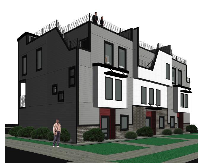
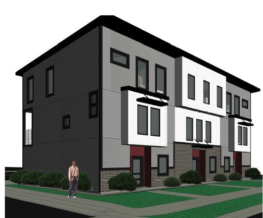
6 South Salt Lake City Planning Commission Work Meeting 6 January 17, 2019 General Plan Considerations: Goal LU-1. Regulate lane uses based on compatibility with surrounding uses, residential areas and economic feasibility. Maintain residential, business and industrial areas that are vibrant and where the health and safety of all are protected. Objective LU-1.2. Preserve businesses and industrial areas. Policy LU Do not allow encroachment into existing residential areas on a lot-by-lot basis. If encroachment is allowed into a residential area, it should be done on a larger scale with significant amenities and buffers installed to upgrade the neighborhood. Goal LU-7. Protect low density residential areas adjacent to business districts. Goal LU-8. Accommodate higher density housing in appropriate areas. Goal HE-1. Seek to supply a broad range of housing types and styles with community sustainability in mind. Goal HE-3. Infill housing should be encouraged. Goal HE-4. Improve the overall home ownership ratio. Ms. White addressed the previous proposals for the property and the outcomes of each. The applicant feels they have alleviated the previous concerns raised by the public and the Planning Commission. She noted that the applicant was proposing rooftop decks for units 1 through 12, and were seeking Planning Commission input on the appropriateness of rooftop decks on units 13 through 15. The rest of the units would not have rooftop decks to preserve the privacy of the surrounding single-family residential homes. Commissioner Veenstra was concerned about creating zoning specific to one parcel and asked if the proposal would create an unwanted precedent. Ms. Vickery explained that they had to take this route in order to process the application. Creating individual zones was not a practice that South Salt Lake City has done in the past, but it is legal. Currently, there is no a mechanism in City Code that would allow the applicant to subdivide the property so that the townhomes could be sold individually. As far as setting precedent, Ms. Vickery did not see an issue. The City Council would make all final decisions on zoning changes. The applicant, Brandon Pearson, gave his address as South Farnsworth Lane in Sandy. He explained that they intend to sell the units individually and make it possible for people to get FHA loans to purchase the units. There will be an HOA and CC&Rs in place to help maintain the exterior of the development. Chair Vernon opened the public hearing. There were no public comments. Chair Vernon closed the public hearing with respect to the Future Land Use Map and amendment to Title 17. The public hearing for the subdivision plat was not closed.
7 South Salt Lake City Planning Commission Work Meeting 7 January 17, 2019 The Planning Commission discussed the rooftop decks and decided not to allow decks on units 13 through 15. A recommendation was made to the South Salt Lake City Council to AMEND the General Plan Future Land Use Map to change the land use designation of a parcel located at 441 East 3900 South, from General Commercial to High Density Residential (16-29 units per acre), to amend the South Salt Lake Zoning Map to change the land use designation of a parcel located at 441 East 3900 South, from Commercial Corridor to Granite Flats Multi-Family Townhome Zone (GFT), for the following reasons: 1. The Future Land Use Map amendment and zoning map amendment are consistent with General Plan Goal HE-1: to seek to supply a broad range of housing types and styles with community sustainability in mind. 2. The future land use map amendment and zoning map amendment are consistent with General Plan Goal HE-4: to improve the overall home ownership ratio in the City. 3. The future land use map amendment and the zoning map amendment are consistent with General Plan Goal HE-3: to encourage infill housing. The Planning Commission restricts rooftop decks to units 1 through 12 only. Motion: Second: Vote: Commissioner Pechmann Commissioner Veenstra Unanimous Motion to recommend to the City Council APPROVAL of a petition to amend Title 17 of the South Salt Lake Municipal Code to include the Granite Flats Multi-Family Townhome (GFT) Zone; and to CONTINUE the final plat approval. Motion: Second: Vote: Commissioner Pechmann Commissioner Huff Unanimous PLANNING COMMISSION BUSINESS 1. Approval of the November 1, 2018 Planning Commission Minutes. Motion to APPROVE the November 1, 2018 Planning Commission minutes, as amended.
8 South Salt Lake City Planning Commission Work Meeting 8 January 17, 2019 Motion: Second: Vote: Commissioner Veenstra Commissioner Pechmann Unanimous 2. Approval of the November 29, 2018 Planning Commission Minutes. Motion to APPROVE the November 29, 2018 Planning Commission minutes, as amended. Motion: Second: Vote: Commissioner Carter Commissioner Huff Unanimous 3. Approval of the December 6, 2018 Planning Commission Minutes. Motion to APPROVE the December 6, 2018 Planning Commission minutes, as amended. Motion: Second: Vote: Commissioner Veenstra Commissioner Pechmann Unanimous STAFF BUSINESS INFORMATION ITEMS There was no staff business. ADJOURNMENT Motion to Adjourn: Second: Vote: Commissioner Veenstra Commissioner Huff Unanimous
9 South Salt Lake City Planning Commission Work Meeting 9 January 17, 2019 The Planning Commission Meeting adjourned at approximately 8:15 p.m. Planning Division Manager For Planning Commission
10
11


12


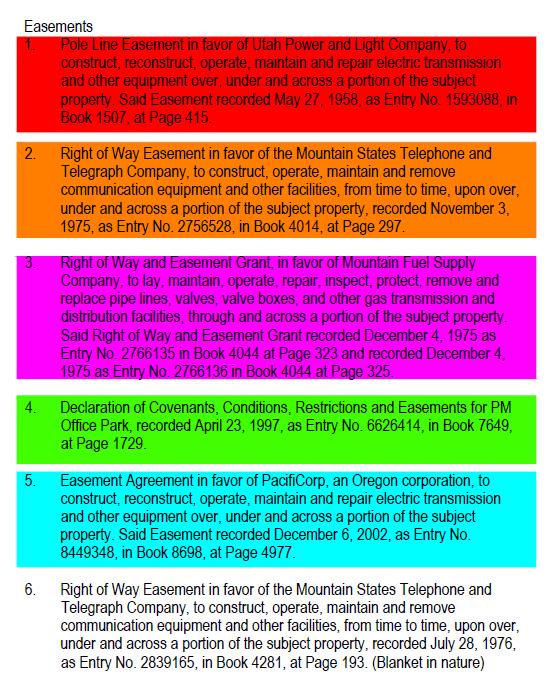
13 WEST TEMPLE MAIN STREET HARMONY PARK 3900 SOUTH


14


15

16
17
18
19
20 N 0 01'33" W ' NORTH SOUTH EAST WEST ' ' ' ' NORTH SOUTH EAST WEST 32.98' NORTH SOUTH EAST WEST ' ' ' ' N NORTH SOUTH EAST WEST ' ' ' ' S 0 15'11" E ' NORTH SOUTH EAST WEST ' ' ' ' NORTH SOUTH EAST WEST 95.11' 95.11' 95.11' 95.11' NORTH SOUTH EAST WEST ' ' ' ' NORTH SOUTH EAST WEST 32.03' S 0 18'36" E NORTH SOUTH EAST WEST 38.25' 38.25' NORTH SOUTH EAST WEST ' ' ' ' NORTH SOUTH EAST WEST 25.00' NORTH SOUTH EAST WEST 5.00' NORTH SOUTH EAST WEST ' ' ' ' NORTH SOUTH EAST WEST 5.17' NORTH SOUTH EAST WEST 43.20' NORTH SOUTH EAST WEST ' ' ' ' NORTH SOUTH EAST WEST ' ' ' ' NORTH SOUTH EAST WEST ' ' ' ' NORTH SOUTH EAST WEST ' ' ' ' HARMONY SQUARE SUBDIVISION LOCATED IN THE SOUTHEAST QUARTER OF SECTION 36, TOWNSHIP 1 SOUTH, RANGE 1 WEST, SALT LAKE BASE & MERIDIAN SOUTH SALT LAKE CITY, SALT LAKE COUNTY, UTAH PLYMOUTH AVE WEST TEMPLE SITE MAIN STREET 3750 SOUTH 3900 SOUTH STATE STREET SURVEYOR'S CERTIFICATE I, PATRICK M. HARRIS do hereby certify that I am a Professional Land Surveyor, and that I hold Certificate No as prescribed under laws of the State of Utah. I further certify that by authority of the Owners, I have made a survey of the tract of land shown on this plat and described below, and have subdivided said tract of land into lots and streets, hereafter to be known as HARMONY SQUARE SUBDIVISION, and that the same has been correctly surveyed and staked on the ground as shown on this plat. SALT LAKE COUNTY UTA TRAX BOUNDARY DESCRIPTION 5' PUE N 89 19'55" E ' 10' PUE 89 45'58" E ' 10' PUE S 0 01'37" E ' VICINITY MAP NOT TO SCALE Beginning at the Southwest Corner Lot 2, Block 16, TEN ACRE PLAT A, BIG FIELD SURVEY, said point being the Easterly Right-of-Way of West Temple Street, said point also being South 89 44'50 West feet and North 0 01'33 West feet from the Street monument at 3900 South Street and West Temple Street; and running thence North 00 01'33" West feet along the Easterly Right-of-Way of West Temple Street; thence North 89 19'55" East feet; thence North 89 45'58" East feet to a point on the Westerly Right-of-Way of Main Street; thence South 00 01'37" East feet along said Right-of-Way; thence South 89 44'58" West feet; thence South 00 01'15" East feet; thence South 89 44'49" West feet; thence South 00 01'30" East 5.17 feet; thence South 89 45'21" West feet; thence South 00 18'36" East 5.00 feet; thence South 89 45'21" West feet; thence South 00 18'36" East feet; thence North 89 52'28" West feet; thence South 00 03'00" East feet; thence South 89 57'00" West feet; thence South 00 15'11" East feet to the Northerly Right-of-Way of 3900 South Street; thence South 89 44'50" West feet along said Right-of-Way to the point of beginning. Contains 232,360 Square Feet or Acres and 1 Lot S 89 44'58" W ' WEST TEMPLE (PUBLIC ROAD) LOT 1 232,360 sq.ft acres 2 S 0 03'00" E ' N 89 52'28" W 32.03' S 89 45'21" W ' S 0 18'36" E 5.00' S 89 45'21" W 25.00' S 0 01'15" E ' S 89 44'49" W 43.20' S 0 01'30" E 5.17' 3828 SOUTH MAIN PROPERTY LLC MAIN STREET (PUBLIC ROAD) Record Easements 1. Pole Line Easement in favor of Utah Power and Light Company, to construct, reconstruct, operate, maintain and repair electric transmission and other equipment over, under and across a portion of the subject property. Said Easement recorded May 27, 1958, as Entry No , in Book 1507, at Page Right of Way Easement in favor of the Mountain States Telephone and Telegraph Company, to construct, operate, maintain and remove communication equipment and other facilities, from time to time, upon over, under and across a portion of the subject property, recorded November 3, 1975, as Entry No , in Book 4014, at Page Right of Way and Easement Grant, in favor of Mountain Fuel Supply Company, to lay, maintain, operate, repair, inspect, protect, remove and replace pipe lines, valves, valve boxes, and other gas transmission and distribution facilities, through and across a portion of the subject property. Said Right of Way and Easement Grant recorded December 4, 1975 as Entry No in Book 4044 at Page 323 and recorded December 4, 1975 as Entry No in Book 4044 at Page Easement Agreement in favor of PacifiCorp, an Oregon corporation, to construct, reconstruct, operate, maintain and repair electric transmission and other equipment over, under and across a portion of the subject property. Said Easement recorded December 6, 2002, as Entry No , in Book 8698, at Page Reciprocal Parking Easement Agreement by and between Staker-Harmony Limited, LLC, a Utah limited liability company and Left Fork, LLC, a Utah limited liability company, dated July 3, 2017 and recorded July 3, 2017 as Entry No in Book at Page Right of Way Easement in favor of the Mountain States Telephone and Telegraph Company, to construct, operate, maintain and remove communication equipment and other facilities, from time to time, upon over, under and across a portion of the subject property, recorded July 28, 1976, as Entry No , in Book 4281, at Page 193. (Blanket in nature) Date PATRICK M. HARRIS P.L.S OWNER'S DEDICATION Known all men by these presents that I / we, the undersigned owner (s) of the above described tract of land, having caused same to be subdivided, hereafter known as the do hereby dedicate for perpetual use of the public all parcels of land shown on this plat as intended for Public use. Owner(s) hereby agree to warrant and defend and save the City harmless against any easements or other encumbrance on a dedicated street which will interfere with the City's use, maintenance, and operation of the street. In witness whereof I / we have hereunto set our hand (s) this day of A.D., 20. By: HARMONY SQUARE SUBDIVISION. By:. LEGEND ENSIGN ENG. LAND SURV. EXISTING STREET MONUMENT SECTION CORNER REBAR WITH YELLOW PLASTIC CAP, OR NAIL STAMPED "ENSIGN ENG. & LAND SURV." BOUNDARY LINE SECTION LINE CENTER LINE EASEMENT LINE STREET MONUMENT 3900 SOUTH WEST TEMPLE (FOUND 2.5" BRASS CAP) 33.00' N 0 01'33" W 32.98' ROCKY MOUNTAIN POWER NOTES: 1. PURSUANT TO UTAH CODE ANN THIS PLAT CONVEYS TO THE OWNER(S) OR OPERATORS OF UTILITY FACILITIES A PUBLIC UTILITY EASEMENT ALONG WITH ALL THE RIGHTS AND DUTIES DESCRIBED THEREIN. 2. PURSUANT TO UTAH CODE ANN A-603(4)(C)(II) ROCKY MOUNTAIN POWER ACCEPTS DELIVERY OF THE PUE AS DESCRIBED IN THIS PLAT AND APPROVES THIS PLAT SOLELY FOR THE PURPOSE OF CONFIRMING THAT THE PLAT CONTAINS PUBLIC UTILITY EASEMENTS AND APPROXIMATES THE LOCATION OF THE PUBLIC UTILITY EASEMENTS, BUT DOES NOT WARRANT THEIR PRECISE LOCATION. ROCKY MOUNTAIN POWER MAY REQUIRE OTHER EASEMENTS IN ORDER TO SERVE THIS DEVELOPMENT. THIS APPROVAL DOES NOT AFFECT ANY RIGHT THAT ROCKY MOUNTAIN POWER HAS UNDER: 2.1. A RECORDED EASEMENT OR RIGHT-OF WAY 2.2. THE LAW APPLICABLE TO PRESCRIPTIVE RIGHTS 2.3. TITLE 54, CHAPTER 8A, DAMAGE TO UNDERGROUND UTILITY FACILITIES OR 2.4. ANY OTHER PROVISION OF LAW. 5' PUE POINT OF BEGINNING 4 S 89 44'50" W ' 5 DOMINION ENERGY NOTE: DOMINION ENERGY APPROVES THIS PLAT SOLELY FOR THE PURPOSE OF CONFIRMING THAT THE PLAT CONTAINS PUBLIC UTILITY EASEMENTS. DOMINION ENERGY MAY REQUIRE OTHER EASEMENTS IN ORDER TO SERVE THIS DEVELOPMENT. THIS APPROVAL DOES NOT CONSTITUTE ABROGATION OR WAIVER OF ANY OTHER EXISTING RIGHTS, OBLIGATIONS OR LIABILITIES PROVIDED BY LAW OR EQUITY. THIS APPROVAL DOES NOT CONSTITUTE ACCEPTANCE, APPROVAL OR ACKNOWLEDGMENT OF ANY TERMS CONTAINED IN THE PLAT, INCLUDING THOSE SET IN THE OWNERS DEDICATION AND THE NOTES AND DOES NOT CONSTITUTE A GUARANTEE OF PARTICULAR TERMS OF NATURAL GAS SERVICE. FOR FURTHER INFORMATION PLEASE CONTACT DOMINION ENERGY'S RIGHT-OF-WAY DEPARTMENT AT S 89 57'00" W 95.11' LEFT FORK, LLC 3900 SOUTH STREET (PUBLIC ROAD) 3 MILNE CONDER HOLDINGS LLC BASIS OF BEARING S 89 44'50" W ' MONTGOMERY PROPERTIES, LLC DEVELOPER CASTLEWOOD DEVELOPMENT, INC SOUTH 1340 EAST STE. 200 SALT LAKE CITY, UTAH STREET MONUMENT 3900 SOUTH & MAIN STREET (FOUND 2.5" BRASS CAP) OLYMPUS SANITARY SEWER DISTRICT APPROVED THIS DAY OF, 20, BY THE OLYMPUS SANITARY SEWER DISTRICT. OLYMPUS SANITARY SEWER DISTRICT HORIZONTAL GRAPHIC SCALE ( IN FEET ) HORZ: 1 inch = 40 ft. PROJECT NUMBER : MANAGER : DRAWN BY : CHECKED BY : DATE : SHEET RQE JWJ 09/04/ OF 1 KFW 7411 STATE OF UTAH County of Salt Lake STATE OF UTAH County of Salt Lake }S.S. On the day of A.D., 20, personally appeared before me, the signer of the foregoing instrument, who duly acknowledged to me that he/she is a, of, a Utah limited liability company, and is authorized to execute the foregoing Agreement in its behalf and that he/she executed it in such capacity. MY COMMISSION EXPIRES:, NOTARY PUBLIC }S.S. On the day of A.D., 20, personally appeared before me, the signer of the foregoing instrument, who duly acknowledged to me that he/she is the, of, a Utah Corporation, and is authorized to execute the foregoing Agreement in its behalf and that he/she executed it in such capacity. MY COMMISSION EXPIRES:, NOTARY PUBLIC CORPORATE ACKNOWLEDGMENT RESIDING IN LIMITED LIABILITY COMPANY ACKNOWLEDGMENT RESIDING IN COUNTY. COUNTY. HARMONY SQUARE SUBDIVISION LOCATED IN THE SOUTHEAST QUARTER OF SECTION 36, TOWNSHIP 1 SOUTH, RANGE 1 WEST, SALT LAKE BASE & MERIDIAN SOUTH SALT LAKE CITY, SALT LAKE COUNTY, UTAH E N S I G N SALT LAKE CITY 45 W S., Suite 500 Sandy, UT Phone: Fax: LAYTON Phone: TOOELE Phone: CEDAR CITY Phone: RICHFIELD Phone: BOARD OF HEALTH APPROVAL APPROVED THIS DAY OF, 20, BY THE BOARD OF HEALTH. CITY PLANNING DIRECTOR APPROVED THIS DAY OF, 20, BY THE SOUTH SALT LAKE CITY PLANNING COMMISSION. CITY ENGINEER DIVISION I HEREBY CERTIFY THAT I HAVE HAD THIS PLAT EXAMINED BY THIS OFFICE AND IT IS CORRECT IN ACCORDANCE WITH INFORMATION ON FILE. JORDAN VALLEY WATER CONSERVANCY DISTRICT APPROVED THIS DAY OF, 20, BY THE JORDAN VALLEY WATER CONSERVANCY DISTRICT. CITY ATTORNEY APPROVED AS TO FORM THIS DAY OF, 20, BY THE SOUTH SALT LAKE CITY ATTORNEY. CITY APPROVAL PRESENTED TO SALT LAKE CITY THIS DAY OF, 20, AND IS HEREBY APPROVED. RECORDED # STATE OF UTAH, COUNTY OF SALT LAKE, RECORDED AND FILED AT THE REQUEST OF : DATE: TIME: BOOK: PAGE: SALT LAKE COUNTY HEALTH DEPT. SOUTH SALT LAKE CITY PLANNING DIRECTOR DATE CITY ENGINEER DATE CITY SURVEYOR DATE JORDAN VALLEY WATER CONSERVANCY DISTRICT DIRECTOR SOUTH SALT LAKE CITY ATTORNEY SOUTH SALT LAKE CITY MAYOR ATTEST: CITY RECORDER FEE$ DEPUTY SALT LAKE COUNTY RECORDER
21 N 0 01'33" W ' NORTH SOUTH EAST WEST ' ' ' ' NORTH SOUTH EAST WEST 32.98' NORTH SOUTH EAST WEST ' ' ' ' N NORTH SOUTH EAST WEST ' ' ' ' S 0 15'11" E ' NORTH SOUTH EAST WEST ' ' ' ' NORTH SOUTH EAST WEST 95.11' 95.11' 95.11' 95.11' NORTH SOUTH EAST WEST ' ' ' ' NORTH SOUTH EAST WEST 32.03' S 0 18'36" E NORTH SOUTH EAST WEST 38.25' 38.25' NORTH SOUTH EAST WEST ' ' ' ' NORTH SOUTH EAST WEST 25.00' NORTH SOUTH EAST WEST 5.00' NORTH SOUTH EAST WEST ' ' ' ' NORTH SOUTH EAST WEST 5.17' NORTH SOUTH EAST WEST 43.20' NORTH SOUTH EAST WEST ' ' ' ' NORTH SOUTH EAST WEST ' ' ' ' NORTH SOUTH EAST WEST ' ' ' ' NORTH SOUTH EAST WEST ' ' ' ' HARMONY SQUARE SUBDIVISION LOCATED IN THE SOUTHEAST QUARTER OF SECTION 36, TOWNSHIP 1 SOUTH, RANGE 1 WEST, SALT LAKE BASE & MERIDIAN SOUTH SALT LAKE CITY, SALT LAKE COUNTY, UTAH PLYMOUTH AVE WEST TEMPLE SITE MAIN STREET 3750 SOUTH 3900 SOUTH STATE STREET SURVEYOR'S CERTIFICATE I, PATRICK M. HARRIS do hereby certify that I am a Professional Land Surveyor, and that I hold Certificate No as prescribed under laws of the State of Utah. I further certify that by authority of the Owners, I have made a survey of the tract of land shown on this plat and described below, and have subdivided said tract of land into lots and streets, hereafter to be known as HARMONY SQUARE SUBDIVISION, and that the same has been correctly surveyed and staked on the ground as shown on this plat. SALT LAKE COUNTY UTA TRAX BOUNDARY DESCRIPTION 5' PUE N 89 19'55" E ' 10' PUE 89 45'58" E ' 10' PUE S 0 01'37" E ' VICINITY MAP NOT TO SCALE Beginning at the Southwest Corner Lot 2, Block 16, TEN ACRE PLAT A, BIG FIELD SURVEY, said point being the Easterly Right-of-Way of West Temple Street, said point also being South 89 44'50 West feet and North 0 01'33 West feet from the Street monument at 3900 South Street and West Temple Street; and running thence North 00 01'33" West feet along the Easterly Right-of-Way of West Temple Street; thence North 89 19'55" East feet; thence North 89 45'58" East feet to a point on the Westerly Right-of-Way of Main Street; thence South 00 01'37" East feet along said Right-of-Way; thence South 89 44'58" West feet; thence South 00 01'15" East feet; thence South 89 44'49" West feet; thence South 00 01'30" East 5.17 feet; thence South 89 45'21" West feet; thence South 00 18'36" East 5.00 feet; thence South 89 45'21" West feet; thence South 00 18'36" East feet; thence North 89 52'28" West feet; thence South 00 03'00" East feet; thence South 89 57'00" West feet; thence South 00 15'11" East feet to the Northerly Right-of-Way of 3900 South Street; thence South 89 44'50" West feet along said Right-of-Way to the point of beginning. Contains 232,360 Square Feet or Acres and 1 Lot S 89 44'58" W ' WEST TEMPLE (PUBLIC ROAD) LOT 1 232,360 sq.ft acres 2 S 0 03'00" E ' N 89 52'28" W 32.03' S 89 45'21" W ' S 0 18'36" E 5.00' S 89 45'21" W 25.00' S 0 01'15" E ' S 89 44'49" W 43.20' S 0 01'30" E 5.17' 3828 SOUTH MAIN PROPERTY LLC MAIN STREET (PUBLIC ROAD) Record Easements 1. Pole Line Easement in favor of Utah Power and Light Company, to construct, reconstruct, operate, maintain and repair electric transmission and other equipment over, under and across a portion of the subject property. Said Easement recorded May 27, 1958, as Entry No , in Book 1507, at Page Right of Way Easement in favor of the Mountain States Telephone and Telegraph Company, to construct, operate, maintain and remove communication equipment and other facilities, from time to time, upon over, under and across a portion of the subject property, recorded November 3, 1975, as Entry No , in Book 4014, at Page Right of Way and Easement Grant, in favor of Mountain Fuel Supply Company, to lay, maintain, operate, repair, inspect, protect, remove and replace pipe lines, valves, valve boxes, and other gas transmission and distribution facilities, through and across a portion of the subject property. Said Right of Way and Easement Grant recorded December 4, 1975 as Entry No in Book 4044 at Page 323 and recorded December 4, 1975 as Entry No in Book 4044 at Page Easement Agreement in favor of PacifiCorp, an Oregon corporation, to construct, reconstruct, operate, maintain and repair electric transmission and other equipment over, under and across a portion of the subject property. Said Easement recorded December 6, 2002, as Entry No , in Book 8698, at Page Reciprocal Parking Easement Agreement by and between Staker-Harmony Limited, LLC, a Utah limited liability company and Left Fork, LLC, a Utah limited liability company, dated July 3, 2017 and recorded July 3, 2017 as Entry No in Book at Page (Blanket in nature) 6. Right of Way Easement in favor of the Mountain States Telephone and Telegraph Company, to construct, operate, maintain and remove communication equipment and other facilities, from time to time, upon over, under and across a portion of the subject property, recorded July 28, 1976, as Entry No , in Book 4281, at Page 193. (Blanket in nature) Date PATRICK M. HARRIS P.L.S OWNER'S DEDICATION Known all men by these presents that I / we, the undersigned owner (s) of the above described tract of land, having caused same to be subdivided, hereafter known as the do hereby dedicate for perpetual use of the public all parcels of land shown on this plat as intended for Public use. Owner(s) hereby agree to warrant and defend and save the City harmless against any easements or other encumbrance on a dedicated street which will interfere with the City's use, maintenance, and operation of the street. In witness whereof I / we have hereunto set our hand (s) this day of A.D., 20. By: HARMONY SQUARE SUBDIVISION. LEGEND ENSIGN ENG. LAND SURV. EXISTING STREET MONUMENT SECTION CORNER REBAR WITH YELLOW PLASTIC CAP, OR NAIL STAMPED "ENSIGN ENG. & LAND SURV." BOUNDARY LINE SECTION LINE CENTER LINE EASEMENT LINE STREET MONUMENT 3900 SOUTH WEST TEMPLE (FOUND 2.5" BRASS CAP) 33.00' N 0 01'33" W 32.98' ROCKY MOUNTAIN POWER NOTES: 1. PURSUANT TO UTAH CODE ANN THIS PLAT CONVEYS TO THE OWNER(S) OR OPERATORS OF UTILITY FACILITIES A PUBLIC UTILITY EASEMENT ALONG WITH ALL THE RIGHTS AND DUTIES DESCRIBED THEREIN. 2. PURSUANT TO UTAH CODE ANN A-603(4)(C)(II) ROCKY MOUNTAIN POWER ACCEPTS DELIVERY OF THE PUE AS DESCRIBED IN THIS PLAT AND APPROVES THIS PLAT SOLELY FOR THE PURPOSE OF CONFIRMING THAT THE PLAT CONTAINS PUBLIC UTILITY EASEMENTS AND APPROXIMATES THE LOCATION OF THE PUBLIC UTILITY EASEMENTS, BUT DOES NOT WARRANT THEIR PRECISE LOCATION. ROCKY MOUNTAIN POWER MAY REQUIRE OTHER EASEMENTS IN ORDER TO SERVE THIS DEVELOPMENT. THIS APPROVAL DOES NOT AFFECT ANY RIGHT THAT ROCKY MOUNTAIN POWER HAS UNDER: 2.1. A RECORDED EASEMENT OR RIGHT-OF WAY 2.2. THE LAW APPLICABLE TO PRESCRIPTIVE RIGHTS 2.3. TITLE 54, CHAPTER 8A, DAMAGE TO UNDERGROUND UTILITY FACILITIES OR 2.4. ANY OTHER PROVISION OF LAW. 5' PUE POINT OF BEGINNING RECIPROCAL PARKING EASEMENT AGREEMENT 4 S 89 44'50" W ' DOMINION ENERGY NOTE: DOMINION ENERGY APPROVES THIS PLAT SOLELY FOR THE PURPOSE OF CONFIRMING THAT THE PLAT CONTAINS PUBLIC UTILITY EASEMENTS. DOMINION ENERGY MAY REQUIRE OTHER EASEMENTS IN ORDER TO SERVE THIS DEVELOPMENT. THIS APPROVAL DOES NOT CONSTITUTE ABROGATION OR WAIVER OF ANY OTHER EXISTING RIGHTS, OBLIGATIONS OR LIABILITIES PROVIDED BY LAW OR EQUITY. THIS APPROVAL DOES NOT CONSTITUTE ACCEPTANCE, APPROVAL OR ACKNOWLEDGMENT OF ANY TERMS CONTAINED IN THE PLAT, INCLUDING THOSE SET IN THE OWNERS DEDICATION AND THE NOTES AND DOES NOT CONSTITUTE A GUARANTEE OF PARTICULAR TERMS OF NATURAL GAS SERVICE. FOR FURTHER INFORMATION PLEASE CONTACT DOMINION ENERGY'S RIGHT-OF-WAY DEPARTMENT AT S 89 57'00" W 95.11' LEFT FORK, LLC 3900 SOUTH STREET (PUBLIC ROAD) 3 MILNE CONDER HOLDINGS LLC BASIS OF BEARING S 89 44'50" W ' MONTGOMERY PROPERTIES, LLC DEVELOPER CASTLEWOOD DEVELOPMENT, INC SOUTH 1340 EAST STE. 200 SALT LAKE CITY, UTAH STREET MONUMENT 3900 SOUTH & MAIN STREET (FOUND 2.5" BRASS CAP) OLYMPUS SANITARY SEWER DISTRICT APPROVED THIS DAY OF, 20, BY THE OLYMPUS SANITARY SEWER DISTRICT. OLYMPUS SANITARY SEWER DISTRICT HORIZONTAL GRAPHIC SCALE ( IN FEET ) HORZ: 1 inch = 40 ft. PROJECT NUMBER : MANAGER : DRAWN BY : CHECKED BY : DATE : SHEET RQE JWJ 09/04/ OF 1 KFW 7411 By: STATE OF UTAH County of Salt Lake STATE OF UTAH County of Salt Lake }S.S.. On the day of A.D., 20, personally appeared before me, the signer of the foregoing instrument, who duly acknowledged to me that he/she is a, of, a Utah limited liability company, and is authorized to execute the foregoing Agreement in its behalf and that he/she executed it in such capacity. MY COMMISSION EXPIRES:, NOTARY PUBLIC }S.S. On the day of A.D., 20, personally appeared before me, the signer of the foregoing instrument, who duly acknowledged to me that he/she is the, of, a Utah Corporation, and is authorized to execute the foregoing Agreement in its behalf and that he/she executed it in such capacity. MY COMMISSION EXPIRES:, NOTARY PUBLIC CORPORATE ACKNOWLEDGMENT RESIDING IN LIMITED LIABILITY COMPANY ACKNOWLEDGMENT RESIDING IN COUNTY. COUNTY. HARMONY SQUARE SUBDIVISION LOCATED IN THE SOUTHEAST QUARTER OF SECTION 36, TOWNSHIP 1 SOUTH, RANGE 1 WEST, SALT LAKE BASE & MERIDIAN SOUTH SALT LAKE CITY, SALT LAKE COUNTY, UTAH E N S I G N SALT LAKE CITY 45 W S., Suite 500 Sandy, UT Phone: Fax: LAYTON Phone: TOOELE Phone: CEDAR CITY Phone: RICHFIELD Phone: BOARD OF HEALTH APPROVAL APPROVED THIS DAY OF, 20, BY THE BOARD OF HEALTH. CITY PLANNING DIRECTOR APPROVED THIS DAY OF, 20, BY THE SOUTH SALT LAKE CITY PLANNING COMMISSION. CITY ENGINEER DIVISION I HEREBY CERTIFY THAT I HAVE HAD THIS PLAT EXAMINED BY THIS OFFICE AND IT IS CORRECT IN ACCORDANCE WITH INFORMATION ON FILE. JORDAN VALLEY WATER CONSERVANCY DISTRICT APPROVED THIS DAY OF, 20, BY THE JORDAN VALLEY WATER CONSERVANCY DISTRICT. CITY ATTORNEY APPROVED AS TO FORM THIS DAY OF, 20, BY THE SOUTH SALT LAKE CITY ATTORNEY. CITY APPROVAL PRESENTED TO SALT LAKE CITY THIS DAY OF, 20, AND IS HEREBY APPROVED. RECORDED # STATE OF UTAH, COUNTY OF SALT LAKE, RECORDED AND FILED AT THE REQUEST OF : DATE: TIME: BOOK: PAGE: SALT LAKE COUNTY HEALTH DEPT. SOUTH SALT LAKE CITY PLANNING DIRECTOR DATE CITY ENGINEER DATE CITY SURVEYOR DATE JORDAN VALLEY WATER CONSERVANCY DISTRICT DIRECTOR SOUTH SALT LAKE CITY ATTORNEY SOUTH SALT LAKE CITY MAYOR ATTEST: CITY RECORDER FEE$ DEPUTY SALT LAKE COUNTY RECORDER
22 N 0 01'33" W ' NORTH SOUTH EAST WEST ' ' ' ' NORTH SOUTH EAST WEST 32.98' NORTH SOUTH EAST WEST ' ' ' ' N NORTH SOUTH EAST WEST ' ' ' ' S 0 15'11" E ' NORTH SOUTH EAST WEST ' ' ' ' NORTH SOUTH EAST WEST 95.07' 95.07' 95.07' 95.07' NORTH SOUTH EAST WEST ' ' ' ' NORTH SOUTH EAST WEST 32.03' S 0 18'36" E NORTH SOUTH EAST WEST 38.25' 38.25' NORTH SOUTH EAST WEST ' ' ' ' NORTH SOUTH EAST WEST 25.00' NORTH SOUTH EAST WEST 5.00' NORTH SOUTH EAST WEST ' ' ' ' NORTH SOUTH EAST WEST 5.17' NORTH SOUTH EAST WEST 43.20' NORTH SOUTH EAST WEST ' ' ' ' NORTH SOUTH EAST WEST ' ' ' ' NORTH SOUTH EAST WEST ' ' ' ' NORTH SOUTH EAST WEST ' ' ' ' HARMONY SQUARE SUBDIVISION LOCATED IN THE SOUTHEAST QUARTER OF SECTION 36, TOWNSHIP 1 SOUTH, RANGE 1 WEST, SALT LAKE BASE & MERIDIAN SOUTH SALT LAKE CITY, SALT LAKE COUNTY, UTAH PLYMOUTH AVE WEST TEMPLE SITE MAIN STREET 3750 SOUTH 3900 SOUTH STATE STREET SURVEYOR'S CERTIFICATE I, PATRICK M. HARRIS do hereby certify that I am a Professional Land Surveyor, and that I hold Certificate No as prescribed under laws of the State of Utah. I further certify that by authority of the Owners, I have made a survey of the tract of land shown on this plat and described below, and have subdivided said tract of land into lots and streets, hereafter to be known as HARMONY SQUARE SUBDIVISION, and that the same has been correctly surveyed and staked on the ground as shown on this plat. SALT LAKE COUNTY UTA TRAX BOUNDARY DESCRIPTION 5' PUE N 89 19'55" E ' 10' PUE 89 45'58" E ' 10' PUE S 0 01'37" E ' VICINITY MAP NOT TO SCALE Beginning at the Southwest Corner Lot 2, Block 16, TEN ACRE PLAT A, BIG FIELD SURVEY, said point being the Easterly Right-of-Way of West Temple Street, said point also being South 89 44'50 West feet and North 0 01'33 West feet from the Street monument at 3900 South Street and West Temple Street, and running; thence North 00 01'33" West feet along the Easterly Right-of-Way of West Temple Street; thence North 89 19'55" East feet; thence North 89 45'58" East feet to a point on the Westerly Right-of-Way of Main Street; thence South 00 01'37" East feet along said Right-of-Way; thence South 89 44'58" West feet; thence South 00 01'15" East feet; thence South 89 44'49" West feet; thence South 00 01'30" East 5.17 feet; thence South 89 45'21" West feet; thence South 00 18'36" East 5.00 feet; thence South 89 45'21" West feet; thence South 00 18'36" East feet; thence North 89 52'28" West feet; thence South 00 03'00" East feet; thence South 89 57'00" West feet; thence South 00 15'11" East feet to the Northerly Right-of-Way of 3900 South Street; thence South 89 44'50" West feet along said Right-of-Way to the point of beginning. Contains 233,331 square feet or acres. 4 S 89 44'58" W ' WEST TEMPLE (PUBLIC ROAD) LOT 1 233,311 sq.ft acres S 0 01'15" E ' 3828 SOUTH MAIN PROPERTY LLC MAIN STREET (PUBLIC ROAD) Easements 1. Pole Line Easement in favor of Utah Power and Light Company, to construct, reconstruct, operate, maintain and repair electric transmission and other equipment over, under and across a portion of the subject property. Said Easement recorded May 27, 1958, as Entry No , in Book 1507, at Page Right of Way Easement in favor of the Mountain States Telephone and Telegraph Company, to construct, operate, maintain and remove communication equipment and other facilities, from time to time, upon over, under and across a portion of the subject property, recorded November 3, 1975, as Entry No , in Book 4014, at Page Right of Way and Easement Grant, in favor of Mountain Fuel Supply Company, to lay, maintain, operate, repair, inspect, protect, remove and replace pipe lines, valves, valve boxes, and other gas transmission and distribution facilities, through and across a portion of the subject property. Said Right of Way and Easement Grant recorded December 4, 1975 as Entry No in Book 4044 at Page 323 and recorded December 4, 1975 as Entry No in Book 4044 at Page Declaration of Covenants, Conditions, Restrictions and Easements for PM Office Park, recorded April 23, 1997, as Entry No , in Book 7649, at Page Easement Agreement in favor of PacifiCorp, an Oregon corporation, to construct, reconstruct, operate, maintain and repair electric transmission and other equipment over, under and across a portion of the subject property. Said Easement recorded December 6, 2002, as Entry No , in Book 8698, at Page Date PATRICK M. HARRIS P.L.S N 89 52'28" W 32.03' S 89 45'21" W ' S 0 18'36" E 5.00' S 89 45'21" W 25.00' S 89 44'49" W 43.20' S 0 01'30" E 5.17' 6. Right of Way Easement in favor of the Mountain States Telephone and Telegraph Company, to construct, operate, maintain and remove communication equipment and other facilities, from time to time, upon over, under and across a portion of the subject property, recorded July 28, 1976, as Entry No , in Book 4281, at Page 193. (Blanket in nature) OWNER'S DEDICATION Known all men by these presents that I / we, the undersigned owner (s) of the above described tract of land, having caused same to be subdivided, hereafter known as the HARMONY SQUARE SUBDIVISION 2 S 0 03'00" E ' do hereby dedicate for perpetual use of the public all parcels of land shown on this plat as intended for Public use. Owner(s) hereby agree to warrant and defend and save the City harmless against any easements or other encumbrance on a dedicated street which will interfere with the City's use, maintenance, and operation of the street. In witness whereof I / we have hereunto set our hand (s) this day of A.D., 20. By:. By:. LEGEND ENSIGN ENG. LAND SURV. EXISTING STREET MONUMENT SECTION CORNER REBAR WITH YELLOW PLASTIC CAP, OR NAIL STAMPED "ENSIGN ENG. & LAND SURV." BOUNDARY LINE SECTION LINE CENTER LINE EASEMENT LINE STREET MONUMENT 3900 SOUTH WEST TEMPLE (FOUND 2.5" BRASS CAP) 33.00' N 0 01'33" W 32.98' ROCKY MOUNTAIN POWER NOTES: 1. PURSUANT TO UTAH CODE ANN THIS PLAT CONVEYS TO THE OWNER(S) OR OPERATORS OF UTILITY FACILITIES A PUBLIC UTILITY EASEMENT ALONG WITH ALL THE RIGHTS AND DUTIES DESCRIBED THEREIN. 2. PURSUANT TO UTAH CODE ANN A-603(4)(C)(II) ROCKY MOUNTAIN POWER ACCEPTS DELIVERY OF THE PUE AS DESCRIBED IN THIS PLAT AND APPROVES THIS PLAT SOLELY FOR THE PURPOSE OF CONFIRMING THAT THE PLAT CONTAINS PUBLIC UTILITY EASEMENTS AND APPROXIMATES THE LOCATION OF THE PUBLIC UTILITY EASEMENTS, BUT DOES NOT WARRANT THEIR PRECISE LOCATION. ROCKY MOUNTAIN POWER MAY REQUIRE OTHER EASEMENTS IN ORDER TO SERVE THIS DEVELOPMENT. THIS APPROVAL DOES NOT AFFECT ANY RIGHT THAT ROCKY MOUNTAIN POWER HAS UNDER: 2.1. A RECORDED EASEMENT OR RIGHT-OF WAY 2.2. THE LAW APPLICABLE TO PRESCRIPTIVE RIGHTS 2.3. TITLE 54, CHAPTER 8A, DAMAGE TO UNDERGROUND UTILITY FACILITIES OR 2.4. ANY OTHER PROVISION OF LAW. 5' PUE POINT OF BEGINNING 5 S 89 44'50" W ' DOMINION ENERGY NOTE: DOMINION ENERGY APPROVES THIS PLAT SOLELY FOR THE PURPOSE OF CONFIRMING THAT THE PLAT CONTAINS PUBLIC UTILITY EASEMENTS. DOMINION ENERGY MAY REQUIRE OTHER EASEMENTS IN ORDER TO SERVE THIS DEVELOPMENT. THIS APPROVAL DOES NOT CONSTITUTE ABROGATION OR WAIVER OF ANY OTHER EXISTING RIGHTS, OBLIGATIONS OR LIABILITIES PROVIDED BY LAW OR EQUITY. THIS APPROVAL DOES NOT CONSTITUTE ACCEPTANCE, APPROVAL OR ACKNOWLEDGMENT OF ANY TERMS CONTAINED IN THE PLAT, INCLUDING THOSE SET IN THE OWNERS DEDICATION AND THE NOTES AND DOES NOT CONSTITUTE A GUARANTEE OF PARTICULAR TERMS OF NATURAL GAS SERVICE. FOR FURTHER INFORMATION PLEASE CONTACT DOMINION ENERGY'S RIGHT-OF-WAY DEPARTMENT AT S 89 57'00" W 95.07' LEFT FORK, LLC 3900 SOUTH STREET (PUBLIC ROAD) 3 MILNE CONDER HOLDINGS LLC BASIS OF BEARING S 89 44'50" W ' MONTGOMERY PROPERTIES, LLC DEVELOPER CASTLEWOOD DEVELOPMENT, INC SOUTH 1340 EAST STE. 200 SALT LAKE CITY, UTAH STREET MONUMENT 3900 SOUTH & MAIN STREET (FOUND 2.5" BRASS CAP) OLYMPUS SANITARY SEWER DISTRICT APPROVED THIS DAY OF, 20, BY THE OLYMPUS SANITARY SEWER DISTRICT. OLYMPUS SANITARY SEWER DISTRICT HORIZONTAL GRAPHIC SCALE ( IN FEET ) HORZ: 1 inch = 40 ft. PROJECT NUMBER : MANAGER : DRAWN BY : CHECKED BY : DATE : SHEET RQE JWJ 09/04/ OF 1 KFW 7411 STATE OF UTAH County of Salt Lake STATE OF UTAH County of Salt Lake }S.S. On the day of A.D., 20, personally appeared before me, the signer of the foregoing instrument, who duly acknowledged to me that he/she is a, of, a Utah limited liability company, and is authorized to execute the foregoing Agreement in its behalf and that he/she executed it in such capacity. MY COMMISSION EXPIRES:, NOTARY PUBLIC }S.S. On the day of A.D., 20, personally appeared before me, the signer of the foregoing instrument, who duly acknowledged to me that he/she is the, of, a Utah Corporation, and is authorized to execute the foregoing Agreement in its behalf and that he/she executed it in such capacity. MY COMMISSION EXPIRES:, NOTARY PUBLIC CORPORATE ACKNOWLEDGMENT RESIDING IN LIMITED LIABILITY COMPANY ACKNOWLEDGMENT RESIDING IN COUNTY. COUNTY. HARMONY SQUARE SUBDIVISION LOCATED IN THE SOUTHEAST QUARTER OF SECTION 36, TOWNSHIP 1 SOUTH, RANGE 1 WEST, SALT LAKE BASE & MERIDIAN SOUTH SALT LAKE CITY, SALT LAKE COUNTY, UTAH E N S I G N SALT LAKE CITY 45 W S., Suite 500 Sandy, UT Phone: Fax: LAYTON Phone: TOOELE Phone: CEDAR CITY Phone: RICHFIELD Phone: BOARD OF HEALTH APPROVAL APPROVED THIS DAY OF, 20, BY THE BOARD OF HEALTH. CITY PLANNING DIRECTOR APPROVED THIS DAY OF, 20, BY THE SOUTH SALT LAKE CITY PLANNING COMMISSION. CITY ENGINEER DIVISION I HEREBY CERTIFY THAT I HAVE HAD THIS PLAT EXAMINED BY THIS OFFICE AND IT IS CORRECT IN ACCORDANCE WITH INFORMATION ON FILE. JORDAN VALLEY WATER CONSERVANCY DISTRICT APPROVED THIS DAY OF, 20, BY THE JORDAN VALLEY WATER CONSERVANCY DISTRICT. CITY ATTORNEY APPROVED AS TO FORM THIS DAY OF, 20, BY THE SOUTH SALT LAKE CITY ATTORNEY. CITY APPROVAL PRESENTED TO SALT LAKE CITY THIS DAY OF, 20, AND IS HEREBY APPROVED. RECORDED # STATE OF UTAH, COUNTY OF SALT LAKE, RECORDED AND FILED AT THE REQUEST OF : DATE: TIME: BOOK: PAGE: SALT LAKE COUNTY HEALTH DEPT. SOUTH SALT LAKE CITY PLANNING DIRECTOR DATE CITY ENGINEER DATE CITY SURVEYOR DATE JORDAN VALLEY WATER CONSERVANCY DISTRICT DIRECTOR SOUTH SALT LAKE CITY ATTORNEY SOUTH SALT LAKE CITY MAYOR ATTEST: CITY RECORDER FEE$ DEPUTY SALT LAKE COUNTY RECORDER
23
24
25
26
27
28
29
30
31
32
33
34


35 1


36 STAFF RECOMMENDATION: STAFF RECOMMENDATION: 2


37 3


38 4
39 5


40 6
41 7
42 o 8


43 LANNING COMMISION OPTIONS: 9
44 10
45 ORDINANCE NO AN ORDINANCE OF THE CITY OF SOUTH SALT LAKE CITY COUNCIL AMENDING THE FUTURE LAND USE MAP OF THE GENERAL PLAN, TITLE 17 OF THE SOUTH SALT LAKE CITY CODE, AND THE SOUTH SALT LAKE CITY ZONING MAP TO REZONE THREE PARCELS, TOTALING 1.69 ACRES, LOCATED AT 441 E 3900 SOUTH FROM GENERAL PLANNED COMMERCIAL USE TO HIGH DENSITY RESIDENTIAL AND FROM THE COMMERCIAL CORRIDOR DISTRICT (CC) TO A NEW GRANITE FLATS MULTIFAMILY TOWNHOME DISTRICT (GFT) WHEREAS, the City Council is authorized by state law to enact and amend ordinances establishing future land use planning and current land use regulations to foster a broad array of public purposes; DRAFT WHEREAS, Property Dynamics Management, LLC has petitioned to rezone three contiguous parcels, totaling 1.69 Acres, and located at 441 East 3900 South (the Property ) from their current zoning designation as Commercial Corridor (CC) to a new zoning designation, Granite Flats Multifamily Townhome (GFT) that will enable a specific townhome development unique to the location; WHEREAS, Property Dynamics Management LLC has petitioned to amend the General Plan Future Land Use Map designation from Commercial to High Density Residential use; WHEREAS, the Property currently consists of abandoned commercial structures that will be demolished as a condition of the proposed General Plan Amendment and Rezone; WHEREAS, the Planning Commission thereafter positively recommended that the Council adopt the proposed ordinance as described below; WHEREAS, the City Council finds that the proposed ordinance promotes economic development and facilitates the orderly subdivision of land; and NOW THEREFORE, BE IT ORDAINED, by the City Council of the City of South Salt Lake City as follows: SECTION I: General Plan Future Land Use Map Amendment. Amend the General Plan Future Land Use Map as depicted below: 1

46 SECTION II: Amend SSLC Code Section as follows: Establishment of districts. A. District Titles. In order to designate DRAFT districts; to regulate location of dwellings, businesses, trades, industries and buildings erected or altered for specified uses; to carry out the intent and purposes of this title, the City of South Salt Lake is divided into land use districts to be known as: Zone District Name Abbreviated Designation Single Family Residential District - 5,000 R1-5,000 Single Family Residential District - 6,000 R1-6,000 Planned Unit Development Overlay District Residential Multiple District Agricultural Residential District Commercial Corridor District Commercial General District Commercial Neighborhood District Professional Office District Business Park District PUD RM A1 CC CG CN PO BP 2
47 Light Industrial District Gateway West Overlay District Transit Oriented Development Overlay District Transit Oriented Development Overlay - Core District Mixed Use District Master Planned Mixed Use District Entertainment Overlay District East Streetcar Neighborhood District Downtown District Community Facilities District DRAFT Open Space District Historic and Landmark District Riverfront R1 Riverfront RM1 Riverfront School Riverfront Flex/Office Granite Flats Multifamily Townhome LI GW TOD TOD - C MU MPMU EO ESN DT CF OS HL R-R1 R-RM1 RS R-FO GFT Residential R1-5,000 (R1-5) District. This district is established to allow for single family detached homes in primarily low density neighborhoods. Residential parcels within this district shall have a minimum lot size of five thousand (5,000) square feet. The improvement of the overall quality of the existing housing stock should be encouraged. New residential structures should be designed so that the height and architectural design should be compatible with the neighborhood and enhance the housing stock of the city. Residential R1-6,000 (R1-6) District. This district is established to allow for single family detached homes in primarily low density neighborhoods. Residential parcels within this district shall have a 3
48 minimum lot size of six thousand (6,000) square feet. The improvement of the overall quality of the existing housing stock should be encouraged. New residential structures should be designed so that the height and architectural design should be compatible with the neighborhood and enhance the housing stock of the city. Planned Unit Development Overlay (PUD) District. This district is established to allow for and encourage housing that is compatible with surrounding neighborhoods while allowing for flexibility in single family residential lot sizes and varying multifamily densities. All developments are intended to complement and strengthen existing neighborhoods as a compatible component of the city's housing stock. Residential Multiple (RM) District. This district is established to allow for residential developments of varying densities. The district offers housing that will appeal to a wide variety of tenants and home owners. Densities and building heights will be compatible with surrounding uses. The district encourages more compact building design and higher residential densities than the surrounding residential uses without sacrificing parking or open space. Efforts shall be made by the city and developers to protect surrounding residential areas and to mitigate impacts of higher densities, heights and vehicle traffic on adjacent neighborhoods. Agricultural Residential (A1) District. This district is established to allow for low density single family homes on larger parcels of land. Residential parcels within this district shall have a minimum lot size of one-half acre. This district is characterized by the preservation of larger parcels for limited agricultural uses and for the raising for large animals and livestock. DRAFT Commercial Corridor (CC) District. This district is established to allow for retail businesses and related uses to be grouped together along the city's principle arterial transportation corridors. The city promotes development that will enhance the corridor through architecture and site design standards. Commercial General (CG) District. This district is established to allow for diverse but compatible, office, warehouse, and commercial and manufacturing business activities. This district is characterized by its large day time population and is a major employment district in the city. Commercial Neighborhood (CN) District. This district is established to allow for the creation of commercial nodes to serve the retail and service needs of neighborhood areas in South Salt Lake. The commercial neighborhood district designation is intended for commercial developments that will not generate significantly greater vehicle traffic. It is intended that businesses in this district will enhance and be compatible with the surrounding residential neighborhoods through architecture, development, and site design as well as provide retail space within walking distance of nearby residences. Professional Office (PO) District. This district is established to provide an area for professional and business offices. In many instances this districts acts as a buffer between residential neighborhoods and transit corridors or commercial uses. Developments adjacent to residential uses should be architecturally compatible while mitigating impacts regarding height, hours of operation, lighting and traffic on surrounding residential neighborhoods Business Park (BP) District. This district is established to provide areas for commerce, service, research and employment activities. This district is characterized by its campus-like site and building design. Buildings in this district are similar in architectural design and function. Light Industrial (LI) District. This district is established to provide for an area of diverse but integrated industrial, manufacturing, warehouse and commercial uses. Emphasis is placed on achieving an aesthetically attractive, functional district with a wide range of industrial and commercial activities. This district is characterized its large day time population and is a major employment district in the city. 4
49 Gateway West Overlay (GW) District. This district is established to create an area that can be recognizable as a gateway into the city on its west boundary at 3300 South and the Jordan River. The district will allow for and promote a combination of residential, commercial and office land uses which might normally be regarding as incompatible. Building and site design standards are increased in this overlay district to create an identity as a gateway for the city of South Salt Lake. Transit Oriented Development Overlay (TOD) District. This district is established to allow for uses to maximize the resource of mass transit, including the creation of new medium-density residential neighborhoods along the corridor. The district will allow for and promote a combination of residential, commercial and office land uses which might normally be regarding as incompatible. New housing is intended to be neighborhood scale. The overlay districts are established around or near light rail corridors to allow for more efficient use of land and provide multiple transportation choices including biking and pedestrian oriented facilities. Incentives for design, open space and parking may be granted by the city in order to promote more efficient use of land and mass transit ridership. Building and site designs in these areas shall create an identity for the overlay district and encourage sustainable site and building practices. The overlay district will encourage more compact building design, medium residential densities as defined in the South Salt Lake City General Plan and mix of uses. Efforts shall be made by the city and developers to protect surrounding residential, commercial and industrial areas and to mitigate impacts of higher densities, heights and traffic on the adjacent uses. Development guidelines should follow as closely as possible the Light Rail Corridor Master Plan as adopted by the South Salt Lake City Council. DRAFT Transit Oriented Development Overlay - Core (TOD - C) District. This district is established to allow for uses to maximize the resource of mass transit, including the creation of new high-density mixed use neighborhoods adjacent to transit stations. The district will allow for and promote a combination of residential, commercial and office land uses which might normally be regarding as incompatible. The overlay districts are established generally within one-half-mile of light rail stations to allow for more efficient use of land and provide multiple transportation choices including biking and pedestrian oriented facilities. Incentives for design, open space and parking may be granted by the city in order to promote more efficient use of land and mass transit ridership. Building and site designs in these areas shall create an identity for the overlay district and encourage sustainable site and building practices. The overlay district will encourage more compact building design, higher residential densities, and mix of uses. Efforts shall be made by the city and developers to protect surrounding residential, commercial and industrial areas and to mitigate impacts of higher densities, heights and traffic on the adjacent uses. Development guidelines should follow as closely as possible the Light Rail Corridor Master Plan as adopted by the South Salt Lake City Council. Mixed Use (Mixed) District. This district is established to integrate and encourage a combination of residential, commercial and office land uses which might normally be regarded as incompatible. Mixed use districts are established around or near light rail, street car and arterial transportation corridors to allow for more efficient use of land and provide multiple transportation choices including biking and pedestrian oriented facilities. Design standards are increased in these areas to create an identity for the district and to encourage more sustainable site and building practices. The mixed use district will encourage more compact building design, higher residential densities than the surrounding residential uses, mix of uses and preservation of open space. Efforts shall be made by the city and developers to protect surrounding residential areas and to mitigate impacts of higher densities, heights and traffic on the adjacent neighborhood. Master Planned Mixed Use (MPMU) District. This district is intended to provide complete mixed use neighborhoods in critical redevelopment areas. Development in this district will include connections between residences, employment, institutional and community uses, open space amenities, existing 5
50 roads, and regional open space and transit facilities. The master planned mixed use district will provide quality commercial and residential design to attract a diversity of residents and employers. East Streetcar Neighborhood (ESN) District. The East Streetcar neighborhood district is established to facilitate the redevelopment of the East Streetcar neighborhood in a manner compatible with the South Salt Lake City General Plan and the East Streetcar Master Plan. Redevelopment in this corridor will be transit-oriented and will preserve the land values and integrity of surrounding single-family neighborhoods. Land uses and regulations for buildings and site development in the East Streetcar corridor district are established in the East Streetcar Form Based Code. Downtown (DT) District. This is established to facilitate the redevelopment of Downtown South Salt Lake as a regional mixed use center in a manner compatible with the Wasatch Choice for 2040 Regional Growth Principles, the South Salt Lake City General Plan and the Downtown South Salt Lake Master Plan. Redevelopment in this district is intended to transform it into a walkable, urban place to serve as a city center. Redevelopment in this district is intended to transform it into a walkable, urban place to serve as a city center. Land uses and regulations for buildings and site development in the Downtown South Salt Lake district are established in the Downtown South Salt Lake Zoning Ordinance and Design Standards. Entertainment Overlay (EO) District. This district is established to provide areas for entertainment type uses such as movie theaters, live entertainment centers, indoor recreation centers, and restaurants and dance clubs. This district will create a twenty-four-hour presence and will be required to be compatible with surrounding and adjacent DRAFT uses. Uses within the district may have an impact on surrounding neighborhoods so appropriate reviews will be required to mitigate the impacts of noise, parking, hours of operation and buffering. Community Facilities (CF) District. This district is established to provide a district for public and quasi-public uses. This district will include uses that are directed toward residents of the community. Uses within this district provide services, entertainment, and recreation, cultural and educational opportunities. Facilities also include uses to provide basic utilities to the residents of South Salt Lake. Open Space (OP) District. This district is established to protect the city's natural and developed open spaces from encroachment of adjacent uses. The district will allow for a combination of passive and active recreational opportunities to encourage a healthy community. Parcels within this district are primary owned by city, county and state governments and does not include privately owned open space as part of a residential or commercial development. Historic and Landmark (HL) District. This district is established to protect the character of the district where historic buildings, structures and landmarks of historical significance are located. Approval of projects and additions or expansions within this district shall be held to a higher review standard in order to protect the areas of historical significance. Granite Flats Multifamily Townhome (GFT) District. This district is established to allow for owneroccupied residential development in the townhome form. The district allows common wall building design and higher residential densities up to 17 units per acre, limited to three story structures, aligned in a configuration specifically approved by the Planning Commission. Units adjoining existing residential development shall not include rooftop use or occupancy. SECTION III: Add new SSLC Code Section as follows: Granite Flats Multifamily Townhome Zone (GFT) A. Uses. Uses within this zone are described in Chapter 15 of this Title. 6

51 B. Density. Project density is limited to residential development at up to 17 units per acre in the configuration designated in subsection C. C. Site Plan and Unit Configuration. Upon subdivision, the project site plan and unit configuration shall be: D. Development Design Regulations. In addition to Chapter 17.21, the following regulations apply: 1. Minimum project area is 1.6 acres; DRAFT 2. The project may not include more than nine townhome buildings: 3. Only Units 1 through 9 [12?]as depicted above may include rooftop access or use; 4. Offsite noise projected from rooftop access or use is prohibited from 10:00 pm to 8:00 am. SECTION IV: Amendment. Amend SSLC Code Section to add the Granite Flats Townhome District to the Land Use Matrix as follows: 7
52 Granite Flats Townhome Land Use Categories Accessory Structure Agriculture/Horticulture, Urban or Community P Alcoholic Beverage Class A License off premise Alcoholic Beverage, Class B License on premise Alcoholic Beverage, Class C Tavern Alcoholic Beverage Package Agency Alcoholic Beverage State Liquor Store DRAFT All-Terrain Vehicles (ATV), Motorcycle, Wave Runners, Snow Mobile Sales & Service Animal Hospital / Veterinary Office (small animal) Animal Boarding / Raising (Farm) Animal, Family Food Production Animal Kennel / Day Care, Commercial Animal / Reptile Rescue Apiary Aviary Art Gallery Art Studio ATM, Kiosk, Vending Machine - Self 8
53 Service, Interactive, Outdoors Auction House Auto Auction Auto, Light Trucks, RV, Boat and Trailer Dealerships (new and used)- Sales and Service Auto, Light Trucks, RV Rental and leasing agencies Auto Body Repair Auto Body Restoration Automotive Service and Repair Automotive Service Station, Nonmechanical Bakery, Commercial Bakery, Neighborhood Bail Bonds DRAFT Barber Shop, Beauty Salon Blood/ Plasma Donation Centers, Commercial and not Accessory to a Medical Clinic Bowling Alley Car Wash Church, Religious or Ecclesiastical Building Commercial Repair Service Convenience Store Convenience Store with Fuel Pumps Convenience Store and Car Wash Craftsman Industrial Crematory, Embalming Facility Cultural Buildings/Uses Dance Studio 9
54 Day Care, Adult Commercial, nonresidential Day Care, Child Commercial Day Spa Drive-Up Window (non-food), Banks, ATM s, Dry Cleaners, Pharmacy, etc. Day Treatment Center Distribution Facilities Dry Cleaning and Laundromat Education, After School Programs, Adult and Children Education, Higher, Public and Private Education, Public, Private, Charter or Quasi Public School Education, Trade, Vocational, Training Employment Agency, Temporary Equestrian Facilities Equipment Sales, Service, Rental, Heavy Equipment and Farm DRAFT Escort / Outcall agencies Farmers Market Financial Institution Fitness, exercise Center Food Carts and Trucks, on Private Property Food Processing Establishments, Large Scale Food Processing Establishments, Small Scale Funeral / Mortuary Home, Stand Alone Building Garage/Yard Sales (residential) Golf Course Grooming Services (pets) Haunted House Home Occupation, Category I Home Occupation, Category II Horticulture / Produce Sales 10
55 Hospital Hospital, Specialty Hotel Hotel, Residential Lease, Extended Stay Impound and Tow Lot Industry, Light Jail Juvenile Detention Facility Laboratory, Industrial Laundry, Industrial Library Maintenance Facilities, Vehicle and Transit Manufacturing, Fabrication, Assembly, Processing, Packaging, Manufactured Homes DRAFT Martial Arts Studio, and training Massage Therapy Medical, Dental and Health Care Offices, On-site Medical, dental Research Facilities/Laboratory Model Home Mobile Commissary Kitchen Mobile Food Vending Trailers and Trucks Mobile Food Truck Park Mobile Home Park Movie Studio and Sound Stage Non-Depository Institutions, check cashing, title loan, deferred deposit loans Nursery or Greenhouse, Commercial Office, General / Professional Outdoor Sales and Display 11
56 Park and Ride Facilities Parking, Private, Ground Level, Commercial Parking, Structure/Terrace, Parks, Public and Private Pawn Shop Pedestrian Pathways, Trails and Greenways Permanent Make-Up not including a Tattoo Shop/Parlor Pharmacy Planned Unit Development, Commercial Condominium Portable Shipping Container, Temporary Storage (no human occupancy) Poultry, Urban Precious Metal Purchase/Recycling Printing, Copy Stores DRAFT Printing, General Protective Housing Facility Public/Government Service and Accessory Buildings Public Utility Station Recreation Center Recycling Materials Collection/Drop-Off Facility, Indoor Rehabilitation and Treatment Facilities Research & Development Facility Restaurant, Sit Down Restaurant, Drive-Up Window Retail Merchandise, Stores, Accessory Retail or Wholesale Merchandise Stores, General Retail or Wholesale Merchandise Stores, Neighborhood Secondhand merchandise dealer Sexually Oriented Business 12
57 Granite Flats Townhome Slaughterhouses, Animal Rendering, Tanneries, Animal By Products Plant Smoking Parlor/ Lounge, Head Shop or smoking paraphernalia specialty store Solar Utilities Storage, Vehicles, Outdoors including automobile impound lots Storage Facilities, Indoor Climate Controlled Units Storage Facilities, Warehouse, indoor Storage and Equipment Yards, Outside Tailoring Shop Tattoo Shop / Parlor Temporary Uses, Firework Stands, Christmas Tree Lots, Refreshment Stands, Tire Service Tobacco, Smoke, cigarette, Specialty Store Transitional Care and Rehabilitation DRAFT Theater, Movie Theater, Live Performance Upholstery Shop Zero Lot Line Development SECTION V: Amendment. Amend SSLC Code Section to add the Granite Flats Townhome District to the Residential Land Use Matrix as follows: Land Use Categories Assisted Living Facility Limited Capacity (up to 30 units) (must comply with development standards for that zone i.e., setback, height, bulk, min/max square footage) 13
58 Assisted Living Facility Large (31 units or more) (must comply with development standards for that zone i.e., setback, height, bulk, min/max square footage) Condominiums, Residential Senior Living Facility Group Homes Homeless Shelter Residential Facility for Elderly Persons and Persons with a Disability (must comply with development standards for that zone- i.e., setback, height, bulk, min/max square footage) Live/Work Units Manufactured Homes Multi-Family Complexes Greater than 50 Units DRAFT Nursing Homes and Convalescent Facilities Permanent Supportive Housing Single Family Residence Townhomes/Row Homes P Transitional Housing Facility (must comply with development standards for that zone-i.e., setback, height, bulk, min/max square footage) SECTION VI: Amendment. Amend SSLC Code Section as follows: Development Standards. In addition to requirements of Title 15 of this Code, the following development standards apply: A. Yard Areas. All development shall comply with the setbacks designated for each zone. All yard areas shall be free of any structure and shall not be used for parking, unless otherwise provided herein: 14
59 Commercial Corridor Commercial Neighborhood Commercial General TOD & TOD-Core Mixed Use Professional Office Light Industrial Gateway West Entertainment Overlay R1-6,000 R1-5,000 Residential Multiple Planned Unit Development Riverfront Flex/Office Riverfront RM2 Riverfront R1 The Crossing Anchor Tenant The Crossing 2100 S./State Street Frontage The Crossing Transit Downtown East Streetcar Granite Flats Townhome Units 6,7,12,13,18,19,24,25 Commercial Corridor Commercial Neighborhood Commercial General TOD & TOD-Core Mixed Use Professional Office Light Industrial A-1 Agriculture Residential Gateway West Entertainment Overlay R1-6,000 R1-5,000 Residential Multiple Planned Unit Development Riverfront Flex/Office Riverfront RM1 Riverfront R1 Riverfront school The Crossing Anchor Tenant The Crossing 2100 S./State Street Frontage The Crossing Transit Downtown East Streetcar Granite Flats Townhome Units 1-5,8-11,14-15,20-23 Granite Flats Townhome Units 6,7,12,13,18,19,24,25 Setbacks Front Yard * * * * * 8 8 Corner Side Frontage Yard * * * * * 236ft 2 236ft 2 Side Yard * * * * * 0 8 Side Yard Combined * * * * * 0 20 Rear yard * * * * * 12 0 * See Approved MPMU 1. Yard Requirements and Qualifications. DRAFT a. No yard area visible from the public street shall be used for storage. b. All front and corner side yard areas shall be landscaped according to the landscape standards established in this title. c. Yard areas shall not be used for parking, except for driveways or garages as required by this title. d. Fences, courtyards, and patios may be allowed provided they meet requirements established elsewhere in this title. 2. Build-to Zones. A Build-to Zone is the area of a lot in which the main building façade must be located. A building required to comply with a build to zone may encroach into the front yard. Setbacks Min In Feet * * * * * 0 Max In Feet N/A * * * * * 5 SECTION VII: Amend the SSLC Zoning Map to designate the Granit Flats Townhome District as depicted: 15

60 SECTION VIII. Severability. If any section, subsection, sentence, clause, phrase, or portion of this ordinance is, for any reason, held DRAFT invalid or unconstitutional by any court of competent jurisdiction, such provision shall be deemed a separate, distinct, and independent provision, and such holding shall not affect the validity of the remaining portions of this ordinance. SECTION IX. Conflict with Existing Ordinances, Resolutions, or Policies. To the extent that any ordinances, resolutions, or policies of the City of South Salt Lake conflict with the provisions of this ordinance, this ordinance shall prevail. SECTION X. Effective Date. This ordinance shall become effective upon Mayor s signature and publication, or after fifteen days of transmission to the office of the Mayor if neither approved nor disapproved by the Mayor, and thereafter, publication. DATED this day of BY THE CITY COUNCIL: Ben Pender, Council Chair ATTEST: Craig D. Burton, City Recorder 16
61 City Council Vote as Recorded: Beverly dewolfe Kindred Mila Pender Siwik Thomas Transmitted to the Mayor s office on this day of Craig D. Burton, City Recorder DRAFT MAYOR S ACTION: Dated this day of, ATTEST: Cherie Wood, Mayor Craig D. Burton, City Recorder 17

62 i
63
64
65
66
67
68
69
70
71
72
73
74
75
76
77
78
79
80
Planning Commission Work Meeting Minutes Thursday, October 18, 2018 City Council Chambers 220 East Morris Avenue Time 6:45 p.m.
 Planning Commission Work Meeting Minutes Thursday, October 18, 2018 City Council Chambers 220 East Morris Avenue Time 6:45 p.m. Commission Members Present: Jeremy Carter Susan Dickstein Chad Ewell Beth
Planning Commission Application Summary
 Planning Commission Application Summary Project Name: Academy Office Park Plat Amendment Request Address: 339 West 13490 South Current Zoning: CSD-DPMU Hearing Date: August 11, 2016 Summary of Request
PLANNING DIRECTOR. Approved by the Planning Director on this day of, A.D. 20. day of, A.D. 20. Approved by the Fire Chief on this
 Located in a portion of the West Half of Section 19, Township 5 South, Range 1 East, Salt Lake Base and Meridian. SURVEYOR'S CERTIFICATE I, the undersigned surveyor, do hereby certify that I am a registered
Planning Commission Work Meeting Minutes Thursday, February 7, 2019 City Council Chambers 220 East Morris Avenue Time 6:00 p.m.
 Planning Commission Work Meeting Minutes Thursday, February 7, 2019 City Council Chambers 220 East Morris Avenue Time 6:00 p.m. Commission Members Present: Staff Members Present: Laura Vernon, Chair Jeremy
ADMINISTRATIVE HEARING STAFF REPORT Country Club Acres Second Amended Subdivision Amendment PLNSUB E Parkway Avenue December 12, 2013
 ADMINISTRATIVE HEARING STAFF REPORT Country Club Acres Second Amended Subdivision Amendment PLNSUB2013-00925 2167 E Parkway Avenue December 12, 2013 Planning Division Department of Community & Economic
ABBREVIATION LEGEND SITE INFORMATION:
 SITE INFORMATION: Current Zone: R-3 PUD, governed by Fox Hollow 2nd MDA Basis of Elevations: Northeast Corner of Section 13, T6S, R1W, S.L.B. & M Elevation: 4599.26 (Benchmark) ABBREVIATION LEGEND Owners:
for the Logan Golf and Country Club; and
 CITY OF LOGAN ORDINANCE NO. 16-01 AN ORDINANCE VACATING PUBLIC RIGHTS-OF-WAY INCLUDING 700 NORTH AND 900 NORTH FROM 1600 EAST TO THE EASTERN CITY BOUNDARY, 2000 EAST FROM 700 NORTH TO 900 NORTH AND A BROAD
PLANNING COMMISSION STAFF REPORT SURROUNDING LAND USES. Light Industrial, Office, UDOT Right of Way (Interstate- 15)
") PLANNING COMMISSION STAFF REPORT MEETING DATE: March 21, 2019 PROJECT NUMBER: S-18-014 REQUEST: Final Plat approval for a single lot subdivision ADDRESS: 3535 South 500 West 7 Parcels: 15-36-127-021-0000,
PLANNING COMMISSION STAFF REPORT MEETING DATE: March 21, 2019 PROJECT NUMBER: S-18-014 REQUEST: Final Plat approval for a single lot subdivision ADDRESS: 3535 South 500 West 7 Parcels: 15-36-127-021-0000,
Master Plan, Zoning Amendment and Preliminary Subdivision
 Staff Report PLANNING DIVISION COMMUNITY & ECONOMIC DEVELOPMENT To: From: Salt Lake City Planning Commission Doug Dansie, 801-535-6182, doug.dansie@slcgov.com Date: September 9, 2015 Re: PLNPCM2014-00254/00253
EASEMENT AGREEMENT. WHEREAS, Hall Brothers owns certain real property located in Weber County, Utah ( Hall Brothers Property );
;") When Recorded Return to: Parcel No. EASEMENT AGREEMENT THIS EASEMENT AGREEMENT ( Agreement ) is entered into this day of, 2016 by and between VALLEY DREAMS PROPERTIES, LLC, a Utah limited liability company
When Recorded Return to: Parcel No. EASEMENT AGREEMENT THIS EASEMENT AGREEMENT ( Agreement ) is entered into this day of, 2016 by and between VALLEY DREAMS PROPERTIES, LLC, a Utah limited liability company
AGENDA HAYDEN PLANNING COMMISSION
 AGENDA HAYDEN PLANNING COMMISSION THURSDAY, DECEMBER 14, 2017 7:00 P.M. HAYDEN TOWN HALL 178 WEST JEFFERSON AVENUE REGULAR MEETING 1. CALL TO ORDER, MOMENT OF SILENCE & PLEDGE OF ALLEGIANCE 2. ROLL CALL
SUBDIVISION APPLICATION
 SUBDIVISION APPLICATION Preliminary Plat Minor Plat Final Plat Amended Plat Applicant Name: Owner (if different from applicant) Name: Company: Company: Address: Address: City, State, Zip City, State, Zip
WHEREAS, are existing rights-of-way that extend through Utah State University property that are used the Golf Country Club; and
 CITY Of LOGAN ORDINANCE NO. 16-01 AN ORDINANCE VACATING PUBLIC RIGHTS-Of-WAY INCLUDING 100 NORTH AND 900 NORTH from 1600 EAST TO THE EASTERN CITY BOUNDARY, 2000 EAST from 100 NORTH TO 900 NORTH AND A BROAD
E. 140TH AVE. VICINITY MAP SCALE: 1"=600' LAND USE TABLE NET AREA 599,946 SQFT AC. GROSS AREA 741,420 SQFT AC.
 SHEET OF PURPOSE STATEMENT: THIS PLAT IS INTENDED TO SUBDIVIDE. ACRES INTO SINGLE FAMILY ATTACHED LOTS, TRACTS, DEDICATE AND GRANT EASEMENTS. LEGAL DESCRIPTION: THE UNDERSIGNED BEING THE OWNER(S) OF A
ORDINANCE NO
 Draft No. 12-21 ORDINANCE NO. 2012-23 AN ORDINANCE ACCEPTING A RIGHT-OF-WAY AND UTILITY EASEMENT FOR WATER LINES, SEWER LINES, STORM SEWER LINES AND SUCH OTHER UTILITIES AS ARE NEEDED FROM THE CARTER JONES
VICINITY MAP SCALE 1'' = 2000'
 CITY CREEK ANNEXATION TO THE CITY OF THORNTON LOCATED IN THE SOUTHWEST QUARTER OF SECTION 11 AND THE WEST HALF OF SECTION 14, TOWNSHIP 1 SOUTH, RANGE 68 WEST OF THE 6TH PRINCIPAL MERIDIAN, COUNTY OF ADAMS,
SUBMITTAL REQUIREMENTS: The number indicates the number of copies for submittal (if applicable).
.") Office Use Only Preliminary Long Plat Long Subdivision Applicant Checklist PLANNING, COMMUNITY, & ECONOMIC DEVELOPMENT DEPARTMENT PRELIMINARY LONG PLAT LONG SUBDIVISION CHECKLIST Mailing Address: P.O.
Office Use Only Preliminary Long Plat Long Subdivision Applicant Checklist PLANNING, COMMUNITY, & ECONOMIC DEVELOPMENT DEPARTMENT PRELIMINARY LONG PLAT LONG SUBDIVISION CHECKLIST Mailing Address: P.O.
COVENANT AGREEMENT BETWEEN THE CITY OF RAPID CITY AND GWH PROPERTIES, LLC TO PERMIT CERTAIN ENCROACHMENTS IN PEDESTRIAN AND UTILITY EASEMENT
 PREPARED BY: City Attorney s Office 300 Sixth Street Rapid City, SD 57702 (605) 394-4140 COVENANT AGREEMENT BETWEEN THE CITY OF RAPID CITY AND GWH PROPERTIES, LLC TO PERMIT CERTAIN ENCROACHMENTS IN PEDESTRIAN
STAFF REPORT. Honorable Mayor and City Council
 STAFF REPORT DATE May 22, 2013 TO: FROM: Honorable Mayor and City Council Superintendent, Brandon Graham SUBECT: PURCHASE UTILITY EASEMENT FROM INTERMOUNTAIN POWER AGENCY LOCATED AT EAST SIDE OF 1650 WEST,
Community Development Department Council Chambers, 7:30 PM, December 1, 2016
 STAFF REPORT 2016-35P: Subdivision Community Development Department Council Chambers, 7:30 PM, December 1, 2016 To: From: Re: Paul Luke, Chairman, Skokie Plan Commission Mike Voitik, Planning Technician
PLANNING COMMISSION REPORT Non-Public Hearing Item
 PC Staff Report 09/21/2015 Item No. 2B - 1 PLANNING COMMISSION REPORT Non-Public Hearing Item PC Staff Report 09/212015 ITEM NO. 2B: FINAL PLAT FOR MORGAN ADDITION; 800 MONTEREY WAY (MKM) : Consider a
Community Development Department Council Chambers, 7:30 PM, July 20, 2017
 STAFF REPORT 2017-25P: Subdivision Community Development Department Council Chambers, 7:30 PM, July 20, 2017 To: From: Re: Paul Luke, Chairman, Skokie Plan Commission Mike Voitik, Planning Technician 2017-25P:
Resolution : A Resolution Recommending Approval Of Preliminary and Final Plats For Emma Krumbees Third Addition
 MEMORANDUM June 11, 2018 TO: FROM: SUBJECT: Planning Chairperson Carter Planning Commission Members Administrator Meyer Cynthia Smith Strack, Community Development Director Resolution 18 013: A Resolution
SUBMITTAL REQUIREMENTS: The number indicates the number of copies for submittal (if applicable).
.") Office Use Only Preliminary Long Plat Long Subdivision Applicant Checklist PLANNING, COMMUNITY, & ECONOMIC DEVELOPMENT DEPARTMENT FINAL LONG PLAT LONG SUBDIVISION CHECKLIST Mailing Address: P.O. Box 547,
Office Use Only Preliminary Long Plat Long Subdivision Applicant Checklist PLANNING, COMMUNITY, & ECONOMIC DEVELOPMENT DEPARTMENT FINAL LONG PLAT LONG SUBDIVISION CHECKLIST Mailing Address: P.O. Box 547,
CONCEPT PLAN APPLICATION Meeting with Staff Commercial Projects
 COMMUNITY DEVELOPMENT City of South Salt Lake Community Development Department 220 E. Morris Avenue South Salt Lake City, Utah 84115 Phone (801) 483-6011 Fax (801) 483-6060 CONCEPT PLAN APPLICATION Meeting
AN ORDINANCE TO REZONE A CERTAIN PARCEL OF LAND IN THE CITY OF MOUNTAIN BROOK, ALABAMA FROM RESIDENCE C DISTRICT TO LOCAL BUSINESS DISTRICT
 ORDINANCE NO. 1904 AN ORDINANCE TO REZONE A CERTAIN PARCEL OF LAND IN THE CITY OF MOUNTAIN BROOK, ALABAMA FROM RESIDENCE C DISTRICT TO LOCAL BUSINESS DISTRICT WHEREAS, after due consideration, the City
PLANNING COMMISSION STAFF REPORT
 PLANNING COMMISSION STAFF REPORT Alder-Robinson Subdivision Amending the Amended Plat of the Arcadia Heights Plat A Subdivision Case #PLNSUB2010-00044 2857 East 2100 South June 23, 2010 Applicant: Greg
MINOR SUBDIVISION PLAT
 MINOR SUBDIVISION PLAT Community Development Department 8101 Ralston Road Arvada, Colorado 80002 MINOR SUBDIVISION PLAT Subdivisions consisting of five (5) or fewer lots are eligible for the minor subdivision
EXHIBIT 1. PRIVATE ROAD ACCESS EASEMENT and SHARED ROAD MAINTENANCE AGREEMENT for KENNEDY SHORES LANE. Auction Tracts 1-8
 EXHIBIT 1 PRIVATE ROAD ACCESS EASEMENT and SHARED ROAD MAINTENANCE AGREEMENT for KENNEDY SHORES LANE Auction Tracts 1-8 This Private Road Access Easement and Shared Road Maintenance Agreement for Kennedy
REVIEWED BY: Administrator Counsel Program Mgr.: Tiffany Schaufler Board Committee Engineer Other
 Minnehaha Creek Watershed District REQUEST FOR BOARD ACTION MEETING DATE: May 11, 2017 TITLE: Authorization to Grant a Temporary Easement to the City of Minnetrista RESOLUTION NUMBER: 17-034 PREPARED BY:
UPN PacifiCorp Notice of Property Disposition Sewer Line Easement
 November 7, 2018 VIA ELECTRONIC FILING Public Utility Commission of Oregon 201 High Street SE, Suite 100 Salem, OR 97301-3398 Attn: Filing Center RE: UPN PacifiCorp Notice of Property Disposition Sewer
MINOR SUBDIVISION PLAT
 MINOR SUBDIVISION PLAT Community Development Department 8101 Ralston Road Arvada, Colorado 80002 September 2015 MINOR SUBDIVISION PLAT Subdivisions consisting of five (5) or fewer lots are eligible for
BILL NO (Emergency Measure) ORDINANCE NO. 5072
 ORDINANCE NO. 5072") BILL NO. 5210 (Emergency Measure) ORDINANCE NO. 5072 AN ORDINANCE AUTHORIZING THE MAYOR TO EXECUTE WITH MICHELSON-HADLEY HEIGHTS DEVELOPMENT, LLC, A CONTRACT AND QUIT CLAIM DEED CONVEYING CERTAIN PROPERTIES
BILL NO. 5210 (Emergency Measure) ORDINANCE NO. 5072 AN ORDINANCE AUTHORIZING THE MAYOR TO EXECUTE WITH MICHELSON-HADLEY HEIGHTS DEVELOPMENT, LLC, A CONTRACT AND QUIT CLAIM DEED CONVEYING CERTAIN PROPERTIES
STANDARDIZED LEGAL DESCRIPTIONS AND EXHIBITS
 STANDARDIZED LEGAL DESCRIPTIONS AND EXHIBITS Public Works Department, Engineering Division June 14, 2004 UNIFIED GOVERNMENT STANDARDIZED LEGAL DESCRIPTIONS AND EXHIBITS For: Roads, Bridges, Short Span
Exhibit A: REAL ESTATE TRANSFER AGREEMENT
 Exhibit A: REAL ESTATE TRANSFER AGREEMENT This agreement is made between the City of Urbana, Illinois, a municipal corporation of the State of Illinois (the Seller ), and Homestead Corporation of Champaign-Urbana,
PERMANENT EASEMENT AGREEMENT
 PERMANENT EASEMENT AGREEMENT THIS PERMANENT EASEMENT AGREEMENT ( Agreement ) is made and entered into this day of, 2016 ( Effective Date ), by and between Staker & Parson Companies, a Utah corporation
WATERFORD LANDING COMMUNITY DEVELOPMENT DISTRICT REGULAR MEETING AGENDA
 WATERFORD LANDING COMMUNITY DEVELOPMENT DISTRICT REGULAR MEETING AGENDA January 31, 2019 Waterford Landing Community Development District OFFICE OF THE DISTRICT MANAGER 2300 Glades Road, Suite 410W Boca
APPENDIX C: PLAT SPECIFICATIONS AND CERTIFICATES
 APPENDIX C: PLAT SPECIFICATIONS AND CERTIFICATES A. Drawing. All plats for recording must be submitted on photographically reproducible and dimensionally stable polyester sheets such as Mylar, Cronar or
FINAL PLAT. Community Development Department 8101 Ralston Road Arvada, Colorado 80002
 FINAL PLAT Community Development Department 8101 Ralston Road Arvada, Colorado 80002 September 2015 FINAL SUBDIVISION PLAT Final Subdivision Plat Review Applications for a Final Plat shall be submitted
RESOLUTION TO ACCEPT DEED OF DEDICATION FOR A RELOCATED UTILITY EASEMENT AS SHOWN ON APPROVED SUBDIVISION PLAN FOR THE LOWER MERION HIGH SCHOOL
 Exhibit D RESOLUTION TO ACCEPT DEED OF DEDICATION FOR A RELOCATED UTILITY EASEMENT AS SHOWN ON APPROVED SUBDIVISION PLAN FOR THE LOWER MERION HIGH SCHOOL WHEREAS, the Board of Commissioners of the Township
COUNCIL AGENDA MEMO ITEM NO. III - #1
 COUNCIL AGENDA MEMO ITEM NO. III - #1 FROM: Anton Jelinek, Director of Utilities MEETING: October 24, 2017 SUBJECT: PRESENTER: Permanent Utility and Right-of-Way Easement Anton Jelinek Discussion: At the
NO PROTEST AGREEMENT AND COVENANT RUNNING WITH THE LAND. Parcel #(s): R: T: S: Q: Q: Project Name:
: R: T: S: Q: Q: Project Name:") RETURN TO: COVENANT RUNNING WITH THE LAND Parcel #(s): R: T: S: Q: Q: Project Name: THIS COVENANT RUNNING WITH THE LAND is made and entered into this day of, 20, by, between, and among, herein known as
RETURN TO: COVENANT RUNNING WITH THE LAND Parcel #(s): R: T: S: Q: Q: Project Name: THIS COVENANT RUNNING WITH THE LAND is made and entered into this day of, 20, by, between, and among, herein known as
The Filing Fee for a Minor Plat is $ PLUS $20.00 per lot created
 DEPARTMENT OF COMMUNITY DEVELOPMENT MINOR PLAT PROCEDURE The Filing Fee for a Minor Plat is $250.00 PLUS $20.00 per lot created Description: The purpose of a Minor Plat is to allow property to be platted
MINOR PLAT AMENDMENT APPLICATION CHECK APPLICABLE PERMIT ATTACHMENT:
 240 East Gammon Road Vineyard, Utah 84058 (801) 226-1929 MINOR PLAT AMMENDMENT APPLICATION Please Note: Attachment of request specific documents is required prior to processing your application. APPLICATION
EASEMENT AGREEMENT. WHEREAS, Ferguson is the 100% owner of the property described on Exhibit B attached hereto (the Williams Property );
;") EASEMENT AGREEMENT THIS EASEMENT AGREEMENT ( Agreement ) is entered into as of this day of, 2016, by and between CRAIG FERGUSON ( Ferguson ), and MAMIE DAVIS and JERRY MOORE ( Davis & Moore ), whose legal
EASEMENT AGREEMENT THIS EASEMENT AGREEMENT ( Agreement ) is entered into as of this day of, 2016, by and between CRAIG FERGUSON ( Ferguson ), and MAMIE DAVIS and JERRY MOORE ( Davis & Moore ), whose legal
SUBDIVISION APPLICATION
 STAFF USE ONLY Date Submitted: Received by: Fee paid: Project # REQUIRED SUBMITTALS Application Fee: $600.00 (up to 5 lots) + $50.00 (per lot above 5) Publication Fee: $300.00 Mailing Fee: $6.00 per hearing
The Drainage Encroachment Agreement has been revised as of August 2014.
 Vanderburgh County Surveyor s office Linda Freeman Jeff Mueller, PE, County Surveyor Doug McDonald, PE, LS Chief Deputy Special Deputy The Drainage Encroachment Agreement has been revised as of August
Agreement - Engineering - Underground Right-of-Way Easement. Submitted for your approval and execution is the attached Underground Right-of-Way
 TULSA COUNTY PURCHASING DEPARTMENT DATE: FROM: TO: May 23, 2018 Matney M. EUis Purchasing Director Board of County Commissione -
CITY OF ELK GROVE CITY COUNCIL STAFF REPORT
 CITY OF ELK GROVE CITY COUNCIL STAFF REPORT AGENDA ITEM NO. 8.22 AGENDA TITLE: Adopt resolution granting the Sacramento Area Sewer District (SASD) an easement for sewer and incidental purposes over City-owned
-ii~ ADAMS COUNTY. &,.ee8.& PUBLIC HEARING AGENDA ITEM
 -ii~ ADAMS COUNTY &,.ee8.& PUBLIC HEARING AGENDA ITEM DATE: January 6,2015 SUBJECT: Easement grant to Molson Coors FROM: Jeffery A. Maxwell, P.E., PTOE, Transportation Director~ AGENCYIDEPARTMENT: Transportation
TOWN OF WOODSIDE. Report to Town Council Agenda Item 6 From: Susan George, Town Manager July 26, 2011
 TOWN OF WOODSIDE Report to Town Council Agenda Item 6 From: Susan George, Town Manager July 26, 2011 SUBJECT: RESOLUTION APPROVING A HOLD HARMLESS AND INDEMNIFICATION AGREEMENT FOR THE PROPERTY LOCATED
THIS DECLARATION made this day of, 2016, by Cambridge and Wyndfall Community Association, Inc. ( Association ) and Lennar Carolinas, LLC ( Owner ).
 and Lennar Carolinas, LLC ( Owner ).") Prepared by and return to: Lori P. Jones, Jordan Price, P.O. Box 10669, Raleigh, NC 27605 Indexing: Grantors: Lennar Carolinas, LLC Grantee: Cambridge and Wyndfall Community Association, Inc. NORTH CAROLINA
Prepared by and return to: Lori P. Jones, Jordan Price, P.O. Box 10669, Raleigh, NC 27605 Indexing: Grantors: Lennar Carolinas, LLC Grantee: Cambridge and Wyndfall Community Association, Inc. NORTH CAROLINA
Final Subdivision Plat
 Final Subdivision Plat Application Packet Public Works Department New Development Division 175 East 200 North St. George, UT 84770 Office (435) 627-4120 Dear Applicant, This packet has been prepared to
Cross Reference: Instrument No. A State Parcel No Parcel: TEMPORARY CONSTRUCTION EASEMENT AGREEMENT
 Cross Reference: Instrument No. A199500066899 Project: 92TU000128 State Parcel No. 49-07-18-107-004.000-801 Parcel: 8033304 Date: Version: TEMPORARY CONSTRUCTION EASEMENT AGREEMENT THIS TEMPORARY CONSTRUCTION
Stormwater Treatment Facility Maintenance Agreement
 Stormwater Treatment Facility Maintenance Agreement This Agreement made and entered into this day of, 20, by, (hereinafter referred to as Property Owner") RECITALS: WHEREAS, the Property Owner is the owner
SOUTH DAKOTA BOARD OF REGENTS. Committee on Budget and Finance ******************************************************************************
 SOUTH DAKOTA BOARD OF REGENTS Committee on Budget and Finance AGENDA ITEM: III O DATE: December 12-13, 2012 ****************************************************************************** SUBJECT: Resolution
AGREEMENT FOR TEMPORARY CONSTRUCTION EASEMENT AND PERMANENT SEWER UTILITY EASEMENT
 AGREEMENT FOR TEMPORARY CONSTRUCTION EASEMENT AND PERMANENT SEWER UTILITY EASEMENT This Agreement for Temporary Construction Easement and Permanent Sewer Utility Easement (hereinafter the "Agreement")
DECLARATION OF COVENANT. Made this day of, 20, by. and, ( Owner(s) ) WITNESSETH:
 ) WITNESSETH:") DECLARATION OF COVENANT Made this day of, 20, by and, ( Owner(s) ) (names of the owners of the properties involved). WITNESSETH: WHEREAS, the Owner(s) is (are) the title owner(s) in fee simple of two contiguous
DECLARATION OF COVENANT Made this day of, 20, by and, ( Owner(s) ) (names of the owners of the properties involved). WITNESSETH: WHEREAS, the Owner(s) is (are) the title owner(s) in fee simple of two contiguous
Community Development Department
 Community Development Department Easement Submission Form and Checklist Project Information Project Name: Location/street address: Applicant/Contact Information Applicant: Phone: Applicant e-mail: Owner/Grantor
SUBDIVISION APPLICATION
 SUBDIVISION APPLICATION City of Horn Lake Planning Department 3101 Goodman Road, W Horn Lake, MS 38637 662-342-3559 Fax: 662-342-3485 Applications due the 1st working day of the month. Submit application
DECLARATION OF RESTRICTIVE COVENANTS (AFFORDABLE HOUSING)
") Return recorded copy to: Development and Environmental Regulation Division 115 S. Andrews Avenue, A240 Fort Lauderdale, FL 33301 Document prepared by: DECLARATION OF RESTRICTIVE COVENANTS (AFFORDABLE HOUSING)
Return recorded copy to: Development and Environmental Regulation Division 115 S. Andrews Avenue, A240 Fort Lauderdale, FL 33301 Document prepared by: DECLARATION OF RESTRICTIVE COVENANTS (AFFORDABLE HOUSING)
Plats and subdivisions; mapping requirements. (a) Size Requirements. All land plats presented to the register of deeds for recording in the
 Size Requirements. All land plats presented to the register of deeds for recording in the") 47-30. Plats and subdivisions; mapping requirements. (a) Size Requirements. All land plats presented to the register of deeds for recording in the registry of a county in North Carolina after September
47-30. Plats and subdivisions; mapping requirements. (a) Size Requirements. All land plats presented to the register of deeds for recording in the registry of a county in North Carolina after September
DECLARATION OF RESTRICTIVE COVENANTS (AGE RESTRICTED)
") Return recorded copy to: Development and Environmental Regulation Division 115 S. Andrews Avenue, A240 Fort Lauderdale, FL 33301 Document prepared by: DECLARATION OF RESTRICTIVE COVENANTS (AGE RESTRICTED)
Return recorded copy to: Development and Environmental Regulation Division 115 S. Andrews Avenue, A240 Fort Lauderdale, FL 33301 Document prepared by: DECLARATION OF RESTRICTIVE COVENANTS (AGE RESTRICTED)
when the following proceedings, among others were held and done, to-wit:
 STATE OF COLORADO ) COUNTY OF ADAMS ) At a regular meeting of the Board of County Commissioners for Adams County, Colorado, held at the Administration Building in Brighton, Colorado on the 2 nd day of
PROPERTY EXCHANGE & CONVEYANCE AGREEMENT RECITALS
 PROPERTY EXCHANGE & CONVEYANCE AGREEMENT This Property Exchange and Conveyance Agreement ( Agreement ) is entered into as of the date of execution by and between Laramie Church of Christ, Inc., a Wyoming
AGENDA ITEM G-2 Public Works
 AGENDA ITEM G-2 Public Works STAFF REPORT City Council Meeting Date: 2/23/2016 Staff Report Number: 16-035-CC Consent Calendar: Adopt a resolution accepting Easements and approving the abandonment of two
Land Use & Development Application
 Salt Lake County Public Works Department Planning and Development Services Division 2001 S. State Street #N-3600, Salt Lake City, UT 84190-4050 Phone 385-468-6700 FAX: 385-468-6674 Visit our web site:
Regular Agenda / Public Hearing for Board of Commissioners meeting January 7, 2015
 Rebecca W. Arnold, Commissioner Sara M. Baker, Commissioner Jim D. Hansen, Commissioner Kent Goldthorpe, Commissioner Paul Woods, Commissioner TO: FROM: ACHD Board of Commissioners & Bruce S. Wong, Director
COUNCIL ACTION FORM Meeting Date: September 13, 2012 Staff Contact: John Sullivan, Public Works Director
 COUNCIL ACTION FORM Meeting Date: September 13, 2012 Staff Contact: John Sullivan, Public Works Director Agenda Item: Consider vacation of a Landscape Easement granted to the City of Westwood for the construction
QUEBEC STREET EAST 130TH AVENUE ONEIDA STREET E. 130TH AVE. VALENTIA ST TAMARAC ST EAST 128TH AVENUE MONACO STREET BACHMAN DR. SITE QUINCE ST.
 SHEET OF CASE NO.: SUBA 0-0 PURPOSE STATEMENT: THIS PLAT IS INTENDED TO SUBDIVIDE. ACRES INTO 0 SINGLE FAMILY LOTS, AND TRACTS FOR PARKS, OPEN SPACE, DRAINAGE AND DETENTION, DEDICATE RIGHT-OF-WAY AND GRANT
CITY OF LARKSPUR Staff Report
 DATE: August 29, 2011 CITY OF LARKSPUR Staff Report September 7, 2011 City Council Meeting TO: FROM: SUBJECT: Larkspur City Council Hamid Shamsapour, Director of Public Works A Resolution of the City Council
QUEBEC STREET EAST 130TH AVENUE ONEIDA STREET E. 130TH AVE. VALENTIA ST TAMARAC ST EAST 128TH AVENUE MOACO STREET BACHMAN DR. SITE QUINCE ST.
 SHEET OF CASE NO.: SUBA - PURPOSE STATEMENT: THIS PLAT IS INTENDED TO SUBDIVIDE. ACRES INTO SINGLE FAMILY LOTS, AND TRACTS FOR PARKS, OPEN SPACE, DRAINAGE AND DETENTION, DEDICATE RIGHT-OF-WAY AND GRANT
50-Foot Non-Exclusive EASEMENT AGREEMENT
 50-Foot Non-Exclusive EASEMENT AGREEMENT THIS EASEMENT AGREEMENT is dated this day of _, 20, by Parker Task Force For Human Services (hereafter referred to as "Grantor"), having an address at 20118 East
RESOLUTION NO. R
 RESOLUTION NO. R-2008-1394 RESOLUTION APPROVING ZONING APPLICATION Z2008-00294 (CONTROL NO. 1995-00044) OFFICIAL ZONING MAP AMENDMENT (REZONING) APPLICATION OF FLORIDA SEVASHRAM SANGHA INC. BY JON E. SCHMIDT
SHORT PLAT Information
 Information This form provides information and an explanation of the procedures of a Short Plat. If you have any questions, contact the Planning and Development Services Department at (253) 566-5656. A
REDEVELOPMENT AGENCY STAFF MEMO. REQUIRED ACTION: Adoption of a resolution authorizing the execution of an easement agreement.
 DATE: April 14, 2015 REDEVELOPMENT AGENCY STAFF MEMO ITEM #: PREPARED BY: RE: 8.B. Justin Belliveau Consideration and Adoption of a Resolution of the Board of Directors of the Redevelopment Agency of Salt
DECLARATION OF DRAINAGE EASEMENTS. Document No. Document Title. (Declarant) Recording Data Return Address
 Recording Data Return Address") Document No. DECLARATION OF DRAINAGE EASEMENTS Document Title (Declarant) Recording Data Return Address DOCUMENT PREPARED BY AND AFTER RECORDING RETURN TO: Parcel No. - - - - - - DECLARATION OF DRAINAGE
Document No. DECLARATION OF DRAINAGE EASEMENTS Document Title (Declarant) Recording Data Return Address DOCUMENT PREPARED BY AND AFTER RECORDING RETURN TO: Parcel No. - - - - - - DECLARATION OF DRAINAGE
Honorable Mayor Bill Agan and members of the Richland Hills City Council. Final Plat Richland Hills, Lots 1 & 2, Block 1 Brumlow Addition
 2B - 1 Memorandum To: From: Date: Subject: Honorable Mayor Bill Agan and members of the Richland Hills City Council Jason Moore, Assistant City Manager January 17, 2017 Final Plat Richland Hills, Lots
CITY OF SARALAND FINAL SUBDIVISION PLAT REVIEW
 CITY OF SARALAND FINAL SUBDIVISION PLAT REVIEW Application Number: Date Plat Submitted: Name of Subdivision: Name of Owner: Owner Address: (Street or P.O. Box) Telephone #: (City) (State) (Zip) E-mail:
Environmental and Engineering Services EASEMENT INFORMATION AND EXAMPLE DOCUMENTS
 Environmental and Engineering Services Reddy Chitepu, P.E., Director EASEMENT INFORMATION AND EXAMPLE DOCUMENTS Please refer to the information below when compiling easement documents for submittal to
City of Melissa, Texas Plat Dedication Language
 City of Melissa, Texas Plat Dedication Language [INCLUDE THE FOLLOWING DEDICATION LANGUAGE FOR INDIVIDUALS (MODIFY APPROPRIATELY TO REFLECT EXACTLY AS SHOWN ON PROPERTY DEED)]: NOW THEREFORE, KNOW ALL
Project Name: Application #: Site Address : Assessor s Parcel #(s):
:") Community Development Department 7501 E. Civic Circle Prescott Valley AZ 86314 Phone (928) 759-3050 Fax (928)759-5511 email: comdev@pvaz.net PRELIMINARY DEVELOPMENT PLAN/PLAT APPLICATION SUBMITTAL & CHECKLIST
Community Development Department 7501 E. Civic Circle Prescott Valley AZ 86314 Phone (928) 759-3050 Fax (928)759-5511 email: comdev@pvaz.net PRELIMINARY DEVELOPMENT PLAN/PLAT APPLICATION SUBMITTAL & CHECKLIST
Contract of Sale. Witnesseth:
 Contract of Sale This Agreement made as of this th day of August, 2015 between the CITY OF STAMFORD, a municipal corporation organized and existing under the laws of the State of Connecticut, acting herein
AMENDING PLAT REQUIREMENTS Revised
 City of University Park AMENDING PLAT REQUIREMENTS Revised 9-3-2014 1. The amending plat is prepared with the appropriate certificates printed on the document and three (3) 24 x 36 paper copies are submitted
Sketch & Legal Description of Mitigation Bank and Ingress/Egress Access Easements
 Appendix H: Sketch & Legal Description of Mitigation Bank and Ingress/Egress Access Easements Tippen Bay Wetland Mitigation Bank DeSoto County, Florida Prepared by: September, 2017 Original file
PERMANENT DRAINAGE EASEMENT
 City Project No. Project Name: ; Tr. # Parcel No. (LLC, Corporation, Partnership) PERMANENT DRAINAGE EASEMENT THIS AGREEMENT, made and entered into this day of, 201, by and between, a, hereinafter called
City of Stevenson Planning Department
 City of Stevenson Planning Department (509)427-5970 7121 E Loop Road, PO Box 371 Stevenson, Washington 98648 TO: City Council FROM: Ben Shumaker DATE: January 16 th, 2014 SUBJECT: Bridging Byways Trail
CONSENT ACTION BY THE BOARD OF DIRECTORS OF VENETO IN MIRAMAR CONDOMINIUM ASSOCIATION, INC.
 CONSENT ACTION BY THE BOARD OF DIRECTORS OF VENETO IN MIRAMAR CONDOMINIUM ASSOCIATION, INC. The undersigned, being all of the members of the Board of Directors of Veneto in Miramar Condominium Association,
MINUTES OF A REGULAR PLANNING COMMISSION MEETING HELD, TUESDAY, OCTOBER 11, :30 P.M. ROCKVILLE CITY HALL
 28 MINUTES OF A REGULAR PLANNING COMMISSION MEETING HELD, TUESDAY, OCTOBER 11, 2011 6:30 P.M. ROCKVILLE CITY HALL The meeting was called to order by Chair Toni Honer. Roll call was taken and the following
FINAL PLAT GUIDE TO SUBDIVIDING PROPERTY. Background
 FINAL PLAT GUIDE TO SUBDIVIDING PROPERTY Background A final plat is the second step in the process of subdividing land into separate parcels for future sale or lease. Once a preliminary plat has been approved
OWNER S CERTIFICATE OWNER S NAME STATE OF NORTH DAKOTA ) ) SS COUNTY OF WILLIAMS )
 ) SS COUNTY OF WILLIAMS )") OWNER S CERTIFICATE I, THE UNDERSIGNED, BEING THE SOLE OWNER OF THE LAND PLATTED HEREIN, DO HEREBY VOLUNTARILY CONSENT TO THE EXECUTION OF SAID PLAT, AND DO DEDICATE THE ROAD EASEMENTS, ALLEYS, PARKS,
OWNER S CERTIFICATE I, THE UNDERSIGNED, BEING THE SOLE OWNER OF THE LAND PLATTED HEREIN, DO HEREBY VOLUNTARILY CONSENT TO THE EXECUTION OF SAID PLAT, AND DO DEDICATE THE ROAD EASEMENTS, ALLEYS, PARKS,
Board Review Draft THIS DOCUMENT PREPARED BY: Stewart J. Weiss HOLLAND & KNIGHT LLP 131 S. Dearborn Street 30 th Floor Chicago, Illinois 60603
 THIS DOCUMENT PREPARED BY: Stewart J. Weiss HOLLAND & KNIGHT LLP 131 S. Dearborn Street 30 th Floor Chicago, Illinois 60603 AFTER RECORDING RETURN TO: Cook County Recorder s Box 337 SECOND AMENDMENT TO
CITY AND COUNTY OF BROOMFIELD SUBDIVISION IMPROVEMENT AGREEMENT FOR (PROPERTY NAME - ALL CAPS)
") CITY AND COUNTY OF BROOMFIELD SUBDIVISION IMPROVEMENT AGREEMENT FOR (PROPERTY NAME - ALL CAPS) THIS AGREEMENT, made and entered into this day of, 20, by and between The CITY AND COUNTY OF BROOMFIELD, a
CITY AND COUNTY OF BROOMFIELD SUBDIVISION IMPROVEMENT AGREEMENT FOR (PROPERTY NAME - ALL CAPS) THIS AGREEMENT, made and entered into this day of, 20, by and between The CITY AND COUNTY OF BROOMFIELD, a
VARIANCE PROCESS APPLICATION
 The Department is here to assist you with your development application pursuant to the Community Development Code (CDC). This publication outlines the Variance Process Development Application process of
RECITALS. 3. On January 15, 2019 the Village Plan Commission considered recommended approval of the CSM and the Agreement.
 VILLAGE BOARD VILLAGE OF SHOREWOOD HILLS DANE COUNTY, WISCONSIN RESOLUTION NO. R-2019-1 A RESOLUTION APPROVING OF A CERTIFIED SURVEY MAP AND THE RELEASE OF CROSS EASEMENTS (DPPG, LLC) RECITALS 1. The Village
DECLARATION OF RECIPROCAL ACCESS AND UTILITY EASEMENTS
 ITEM 175-2701-C0517 Page 1 of 6 Return to: Grant Road LLC 1430 Country Manor Boulevard, Suite 3 Billings, MT 59102 DECLARATION OF RECIPROCAL ACCESS AND UTILITY EASEMENTS This Reciprocal Easement Declaration
Village of Mantua, Ohio ORDINANCE
 AN ORDINANCE AUTHORIZING THE MAYOR TO EXECUTE A LEASE / OPTION TO PURCHASE AGREEMENT WITH THE PORTAGE PARK DISTRICT FOR THE HEADWATERS TRAIL WEST OF STATE ROUTE 44, AND DECLARING AN EMERGENCY. WHEREAS,
STANDARD LANGUAGE FORMAT GUIDE PLANNING SERVICES DIVISION
 A. OWNERSHIP CERTIFICATE The purpose of the ownership certificate is to identify the owner and provide the Volume and Page of Deed Records, verifying the ownership. When the property owner is a corporation,
MAJOR SUBDIVISION APPLICATION
 Revised 2.26.18 The Department is here to assist you with your development application pursuant to the Community Development Code (CDC). This publication outlines the Major Subdivision Development Application
ARAPAHOE COUNTY WATER AND WASTEWATER AUTHORITY CONVEYANCE AND ACCEPTANCE OF UTILITY LINES AND FACILITIES (NAME OF DEVELOPMENT)
") ARAPAHOE COUNTY WATER AND WASTEWATER AUTHORITY CONVEYANCE AND ACCEPTANCE OF UTILITY LINES AND FACILITIES (NAME OF DEVELOPMENT), hereinafter called "GRANTOR" for and in consideration of the covenants and
ARAPAHOE COUNTY WATER AND WASTEWATER AUTHORITY CONVEYANCE AND ACCEPTANCE OF UTILITY LINES AND FACILITIES (NAME OF DEVELOPMENT), hereinafter called "GRANTOR" for and in consideration of the covenants and