THIS AGENDA IS SUBJECT TO CHANGE WITH MINIMUM 24-HOURS NOTICE
|
|
|
- Wesley Roberts
- 5 years ago
- Views:
Transcription
 1.")
1 THIS AGENDA IS SUBJECT TO CHANGE WITH MINIMUM 24-HOURS NOTICE PLANNING COMMISSION AGENDA Thursday, July 19, 2018 NOTICE IS HEREBY GIVEN that the Herriman Planning Commission shall assemble for a meeting in the City Council Chambers, located at 5355 W Herriman Main Street, Herriman, Utah. 6:00 PM - Work Meeting (Fort Herriman Conference Room) 1. Review of materials for an LDS Seminary File Number: C Review of materials for an LDS Church File Number: C Discussion regarding improvements to South for the Freeman Subdivision 4. Discussion of proposed Auto Mall Overlay Zone File Number: Z Review of City Council Decisions 6. Review of Agenda Items 7:00 PM - Regular Planning Commission Meeting 1. Call to Order 1.1 Invocation/Thought/Reading and Pledge 1.2 Roll call 1.3 Approval of Minutes for: June 7, Conflicts of Interest 2. Administrative Items Administrative items are reviewed based on standards outlined in the ordinance. Public comment may be taken on relevant and credible evidence regarding the applications compliance with the ordinance. 2.1 Request: Subdivision Amendment for a Lot Line Adjustment Applicant: Jeffrey Tobler Address: S Cedar Butte Dr & 6644 W Cedar Butte Cir Zone: FR-1 (Forestry Recreation 1 acre min.) Acres:.41 File Number: S Request: Exception to the Single Family Design Standards for a Proposed Dome House Applicant: James Dosdall Address: 6043 W Herriman View Way Zone: A-.25 (Agricultural 10,000 sq. ft. min.) Acres:.88 File Number: P
2 THIS AGENDA IS SUBJECT TO CHANGE WITH MINIMUM 24-HOURS NOTICE 3. Legislative Items Legislative items are recommendations to the City Council. Broad public input will be taken and considered on each item. All legislative items recommended at this meeting will be scheduled for a decision at the next available City Council meeting. 3.1 Request: Text Change to the Land Development Code to Create an Accessory Structures Chapter (Public Hearing) Applicant: Herriman City File Number: Z Request: Text Change to the Land Development Code Chapter 16, Table of Uses (Public Hearing) Applicant: Herriman City File Number: Z Chair and Commission Comments 5. Future Meetings 5.1 Planning Commission Meeting August 2, 7:00 PM 5.2 City Council Wednesday, August 8, 7:00 PM 6. Adjournment The Planning Commission Rules of Procedure and Ethical Conduct can be found on the City website at In accordance with the Americans with Disabilities Act, Herriman City will make reasonable accommodation for participation in the meeting. Request assistance by contacting Herriman City at (801) and provide at least 48 hours advance notice of the meeting. ELECTRONIC PARTICIPATION: Members of the planning commission may participate electronically via telephone, Skype, or other electronic means during this meeting. PUBLIC COMMENT POLICY AND PROCEDURE: The purpose of public comment is to allow citizens to address items on the agenda. Citizens requesting to address the commission will be asked to complete a written comment form and present it to Wendy Thorpe, Deputy Recorder. In general, the chair will allow an individual three minutes to address the commission. A spokesperson, recognized as representing a group in attendance, may be allowed up to five minutes. This policy also applies to all public hearings. I, Wendy Thorpe, certify the foregoing agenda was ed to at least one newspaper of general circulation within the geographic jurisdiction of the public body. The agenda was also posted at the principal office of the public body, on the Utah State Website and on Herriman City s website Posted and Dated this 13 th day of July, 2018 Wendy Thorpe Deputy Recorder
3
4
5
6
7
8
9
10
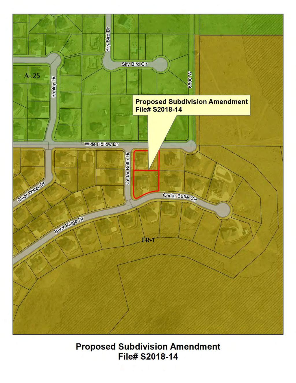
11 Date of Meeting: 07/19/2018 File # S Applicant Jeffrey Tobler Address S Cedar Butte Dr Request Subdivision Amendment for a Lot Line Adjustment
12 Staff Report DATE: July 5, 2018 TO: FROM: Planning Commission Bryn McCarty, AICP, Assistant City Planner MEETING: Planning Commission July 19, 2018 REQUEST: Subdivision plat amendment for a lot line adjustment Applicant: Jeffrey Tobler, property owner Address: S Cedar Butte Drive and 6644 W Cedar Butte Circle Zone: FR-1 (Forestry Recreation 1 acre minimum) Acres: 0.9 of an acre File Number: S Request Jeffrey Tobler is requesting a subdivision plat amendment to adjust the lot line between his lot and his neighbor s lot (to the south). Site The lots are located at S Cedar Butte Drive and 6644 W Cedar Butte Circle. The lots are located within The Cove subdivision. Notices Notices are not required because this item is not a public hearing. Process A subdivision is an administrative decision. Herriman City ordinance states that a public hearing is not required when the request is to: Adjust the lot lines of adjoining lots if the fee owners of each of the adjoining lots join in the application, regardless of whether the lots are located in the same subdivision. For this request, the applicant and the owner of the adjacent lot have both signed the application. The Planning Commission will make a decision based on compliance with the applicable ordinance.
13 Staff Report Discussion While the west end of the side yard fence was correctly placed on or near the property line, the east end of the fence was offset from the property line by approximately 8 feet. The applicant is requesting to change the recorded lot line to match the existing fence line. The adjustment will not create any illegal lots or have any detrimental zoning impact. Recommendation Staff recommends approval of the subdivision plat amendment to adjust the lot line with the following requirements: 1. Compliance with all recommendations received from applicable agencies. 2. Final plat to be reviewed and approved by the City Engineer. 3. Any utilities or utility boxes that need to be relocated shall be done at the expense of the applicant/property owner. Attachments A. Application B. Vicinity Map C. Amended Plat
14
15
16
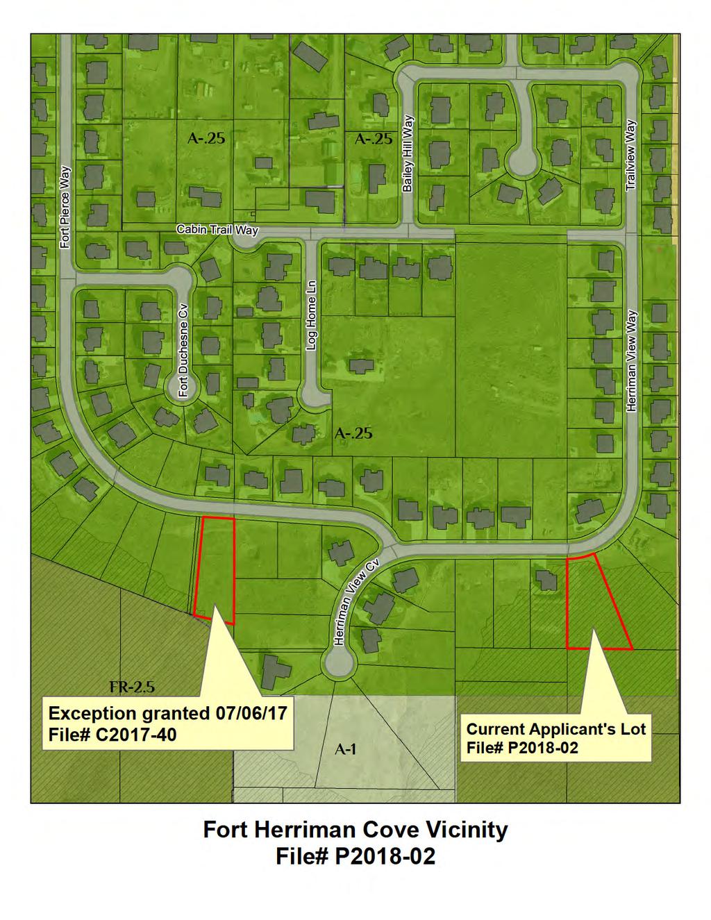
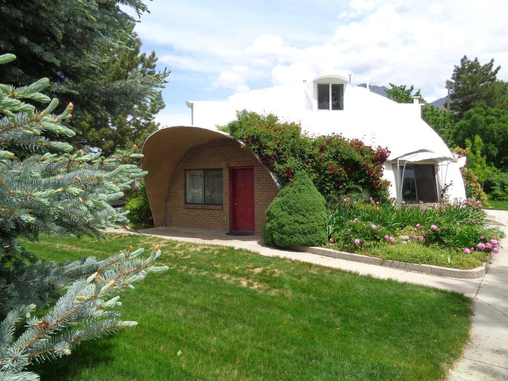
17 Date of Meeting: 07/19/2018 File # P Applicant James Dosdall Address 6043 W Herriman View Way Request Exception to the Single Family Design Standards for a Dome House
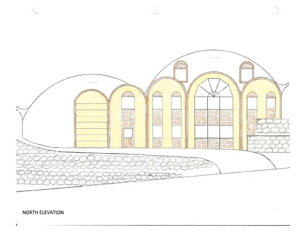
18 Staff Report DATE: July 5, 2018 TO: FROM: Planning Commission Bryn McCarty, AICP, Assistant City Planner MEETING: Planning Commission July 19, 2018 REQUEST: Exception to the Single Family Design Standards Applicant: James Dosdall, property owner Address: 6043 W Herriman View Way Zone: A-.25 (Agricultural 10,000 sq. ft. min.) Acres: 0.88 of an acre File Number: P Request James Dosdall, property owner, is requesting an exception to the single-family design standards to facilitate construction of a dome house on his lot. Site The lot is located at 6043 W Herriman View Way and is in the Fort Herriman Cove subdivision. Notices No notices are required for permitted uses. Process A single family home is a permitted use in A.25 zone. As per E of the Herriman City Land Development Code, a permitted use has the following approval standards: 1. A permitted use shall be allowed if the use: a. Is listed as a permitted use in the zone where the use is located; b. Conforms to development standards of the applicable zone; c. Conforms to applicable requirements of this title; and d. Conforms to any other applicable requirements of this Code. The applicant s request meets three of the four criteria for allowing a permitted use. However, item 1.c. is not met because the proposed design does not meet every condition of the Single-Family Attached or Detached Dwellings Standards (which have been listed in the following section of this staff report).
19 Staff Report Discussion Below are all of the single family design standards listed in section of the Land Development Code. The applicant is asking for an exception to item F, regarding the roof pitch. A. Exterior Materials: Exterior materials for all buildings shall include brick, stucco, stone, or other decorative masonry products including fiber-cement siding as approved by the Planning Commission. A minimum of forty percent (40%) of the front exterior and any side or rear viewable from the street shall be brick or stone. Vinyl and wood siding are not permitted. However, shake shingles may be permitted as an accent material as approved. All sides of dwellings shall receive equal design consideration, particularly where they may be readily viewed by pedestrians and motorists, or from adjacent properties. B. Review of Building Colors and Materials: Building colors and materials shall be reviewed by the Planning Commission at the time of subdivision approval. A materials board shall be submitted with each subdivision application. C. Garages: Dwellings shall include a minimum two car garage (minimum 24 feet by 22 feet, or approximate approved equivalent). D. Parking: The driveway shall be a minimum of twenty-four feet (24') in length. E. Minimum Floor Area: The minimum total floor area, finished and unfinished, of any singlefamily dwelling shall be two thousand four hundred (2,400) square feet. F. Roof Pitch: Main buildings shall be constructed with minimum 5:12 roof pitch. G. Building Elevations: Building elevations shall vary so that the same house is not built within three (3) lots or across the street from the same elevation. H. Deviations: The Planning Commission may approve deviations from one or more of the developmental or architectural standards provided in this section on the basis of a finding that the architectural style proposed provides compensating design features. Item H authorizes the Planning Commission to grant a deviation from the design standard if the Commission finds the architectural style to have compensating design features. Recommendation The Planning Commission will need to determine whether granting a deviation from item F of the single-family design standards is warranted based on the compensating design features of the proposed home.
20 Staff Report Attachments A. Application B. Vicinity Map C. Site Plan D. Grading Plan E. Building elevations F. Supplementary documents provided by applicant
21
22
23
24

25
26
27
28
29
30
31 Fort Herriman Cove lot 410 project: Jim Dosdall 10 July 2018 Human Resources To reassure the Planning Commission that there is some experience and expertise behind the unconventional construction in the proposed project, I submit the following: Our current home at 849 S. Hwy 89 in Springville UT was designed by Arnold Wilson, Professor (Emeritus) of Civil Engineering, Brigham Young University, and author of the definitive work on the subject, Practical Design of Concrete Shells, ISBN: X, published in 2006 by Monolithic Dome Institute. The house was built by and occupied by his son, Craig Wilson, in When we bought it in 2006 and expanded it with a second dome, Prof. Wilson again did the engineering calculations. Now retired, he has recommended to me Chris Zweifel of ZZ Consulting, 1086 N. 900 E., Shelly ID 83274, phone Though their prime client is Domtec International of Idaho Falls ID, builders of large commercial monolithic reinforced concrete domes for auditoriums, churches, schools, and industrial bulk materials storage, Mr. Zweifel does a number of homes each year, has agreed to take this project, and is licensed in Utah. My personal field of expertise is Automotive Engineering (Ford Motor Co., Dearborn MI, Scientific Research Lab, 29 years, 14 patents). I learned House Wiring in the 1950 s through a 4-H club (a remnant of the Rural Electrification Act of the 1930 s) and did the electric and plumbing on our family home in 1960 while working alongside my father who was a builder in the post-war era who did everything from pouring the concrete to the finish cabinetry. Over the years I have had multiple occasions to update my building experience as we stretched houses to accommodate our 13 children, and also our concrete dome construction in Springville in I plan to be the Owner-Builder of this project.
32
33
34
35
36 Date of Meeting: 07/19/2018 File # Z Applicant Herriman City Address Request Text Change to the Land Development Code to Create an Accessory Structures Chapter
37 Staff Report DATE: July 10, 2018 TO: FROM: Planning Commission Craig Evans, Planner I MEETING: Planning Commission July 19, 2018 REQUEST: Text Change to the Land Development Code to Create an Accessory Structures Chapter Applicant: Herriman City File Number: Z Request Herriman City is proposing a text change to Title 10 of the Herriman City Code, which is the Herriman Land Development Code, to create a new chapter dedicated to accessory structures. Notice The City posted the public hearing notice in the newspaper and on the City website on July 9, As of the date of this report, staff has not received any public comments regarding the proposed text change. Process A text change is a legislative action. The Planning Commission holds a public hearing and makes a recommendation to the City Council. The City Council will then hold a public meeting to discuss the item and make the final decision. Discussion In December 2017, the City adopted a new Land Development Code. In the newly adopted code, the ordinances that governed accessory structures were fragmented across numerous chapters. This proposed chapter will significantly increase readability and code consistency, and make future amendments much easier to implement. Recommendation Staff recommends the Commission take comments during the public hearing and continue the item for further refinement and review. Following the hearing, the Commission may discuss additional changes that may be warranted and provide direction to staff regarding the proposal. Attachments A. Proposed Text
38 Chapter 31 ACCESSORY STRUCTURES : Purpose : Permitted Use : Prohibited Uses : Building Elevations : Building Permit Required Structures in Front Yards Open-Roof Accessory Structures Building Setback, Height, and Lot Coverage Restrictions : Purpose The purpose of this chapter is to establish regulations for accessory buildings. These regulations are intended to ensure that accessory buildings do not disturb adjacent neighbors or the residential character of a neighborhood : Permitted Use Permitted. Accessory uses, buildings, and structures shall be permitted in all zones provided they are incidental to, and do not substantially alter a principal use or structure, subject to the provisions of this section and the zone where they are located. No accessory use, building, or structure shall be allowed on a lot unless a permitted or conditional use exists on the same lot Prohibited Uses A. Accessory dwellings of all types are prohibited uses in accessory buildings. B. Accessory buildings may not be used for a home occupation Building Elevations A. The front of any accessory structure and any additional portion of the structure viewable from a public street shall have materials and color similar to the primary dwelling. Buildings located in an A zone and used for agricultural purposes, such as barns or other such buildings to house animals, shall not be subject to this requirement. B. If the accessory building is pre-fabricated, such as a Gorilla Shed or Tuff Shed, the material need not match the primary dwelling, but is still required to be a similar color : Building Permit Required A. An accessory structure requires obtaining a building permit if it: 1. Is larger than 200 square feet. 2. Is attached to the primary dwelling, regardless of size. 3. Is hooked up to electricity, natural gas, or plumbing (water) : Front Yards and Side Yards
39 A. If an accessory building is located in the front yard or side yard of the main building it must meet the same setback requirements as the main building. B. If on a corner lot which rears upon the side yard of adjacent lot the rear yards shall be at least 10 feet : Open-Roof Accessory Structures Open-roof structures such as pergolas and trellises, lacking a solid roof, may be located in the side or rear yard, and must remain at least three feet from any property line : Setback, Height, and Lot Coverage Regulations A. No accessory structure may be taller than the main home, even in the case of severely sloped lots. B. Regulations (See Excel Table Below)
40 : Setback, Height, and Lot Coverage Regulations B. Minimum Yard Zone Front Yard Side Yard Rear Yard 25 feet Located in rear yard: 3 feet All A Zones Maximum Building Height 3 feet Lots smaller than 1/2 acre: 16 feet Maximum Lot Coverage In side and rear yards: 25% of combined side and rear yard area Accessory Building in side or front yard of main building: same requirements as main building Corner lots which rear on side yard of another lot: 10 feet Lots 1/2 acre or larger: 20' In front yard, 25% of front yard area Side yard next to dwelling on adjacent lot: 10 feet Lots 1/2 acre or larger AND side and rear setbacks are 10 feet or greater: 25' Lots 1 acre or larger: 70% of total lot area Corner lots: 20 feet from street side property line R-1 25 feet Located in rear yard: 3 feet 3 feet Lots smaller than 1/2 acre: 16 feet In side and rear yards: 25% of combined side and rear yard area OR less than footprint of main building, whichever is less In side or front yard of main bldg: same req's as main bldg Side yard next to dwelling on adjacent lot: 10 feet Corner lots which rear on side yard of another lot: 10 feet Lots 1/2 acre or larger: 20' Lots 1/2 acre or larger AND side and rear setbacks are 10 feet or greater: 25' In front yard, 25% of front yard area
41 R-2 Determined with PUD Approval Corner lots: 20 feet from street side property line 3 feet 3 feet 16 feet In side and rear yards: 25% of combined side and rear yard area OR less than footprint of main building, whichever is less R-M 19 feet 8 feet 3 feet 16 feet None If located 10 feet from adjacent dwelling: 3 feet Corner lot adjacent to side yard of adjoining lot: 10 feet Corner lots: 20 feet from street MU-2 20 feet None, except as follows: Side yard adjacent to agricultural or residential zone boundary: 20 feet unless reduced by the Planning Commission based on surrounding existing and possible future uses None, except as follows: Rear yard adjacent to lot or parcel in agricultural or residential zone: 30 feet 45 feet 60% of lot - all buildings combined (includes main building) FR-1 FR-2.5 Corner lot: 20 feet 40 feet One side yard: 25 feet Single-family dwelling: 40 feet 16 feet % of lot coverage including all buildings, paved surfaces, and graded areas:
42 FR-5 FR-10 FR-20 Both side yards: 50 feet Corner lot: 35 feet from street One side yard: 30 feet Any portion of uncovered or covered patio or deck: 40 feet FR-1: 20% FR02.5: 15% Single-family dwelling: 40 feet 16 feet % of lot coverage including all buildings, paved surfaces, and graded areas: Both side yards: 60 feet Corner lot: 40 feet from street side property line Any portion of uncovered or covered patio or deck: 40 feet FR-5: 10% FR-10: 5% FR-20: 5%
43 Chapter 3 DEFINITIONS : Purpose : Scope : Rules of Interpretation : Illustrations : Definitions, Generally : Definitions, Land Use Categories : PURPOSE: The purpose of this chapter is to provide rules of interpretation, definitions, and illustrations so that the provisions of this title may be readily understood and consistently administered : SCOPE: The rules of interpretation, definitions, and illustrations contained in this chapter shall apply to the entirety of this title : RULES OF INTERPRETATION: A. General. All provisions, terms, phrases and expressions contained in this chapter shall be liberally construed to accomplish the purposes of this title. B. Conjunctions. Unless the context clearly indicates to the contrary, conjunctions shall be interpreted as follows: shall apply. 1. "And" indicates that all connected items, conditions, provisions or events provisions 2. "Or" indicates that one or more of the connected items, conditions, or events shall apply. or 3. "Either... or" indicates that the connected items, conditions, provisions events shall apply singly but not in combination. conditions, 4. "And/Or" indicates that all or one or more of the connected items, provisions or events shall apply. C. Mandatory and Discretionary Terms: 1. The word "shall" is always mandatory and imposes a duty to act. 2. The word should means the matter described ought to be accomplished if reasonable and possible under the circumstances. 3. The word "may" is permissive and grants discretion or authority to act. 4. The words may not mean an action is prohibited.
44 D. Non-Technical and Technical Words. Words and phrases shall be construed according to the common use and understanding of the language, but technical words and phrases and such others as may have acquired a peculiar and appropriate meaning in law shall be construed and understood according to such meaning. E. Tense, Number, and Gender. Words used in the past or present tense include the future as well as the past or present unless the context clearly indicates the contrary. The singular shall include the plural and the plural shall include the singular as the context and application of this title may reasonably suggest. Words of one gender shall apply to any person, natural or fictitious, regardless of gender, as the context and application of this title may reasonably suggest. F. Fractional Numbers. In determining compliance with the numerical requirements of this title any computation or measurement resulting in a fractional number shall be rounded to the nearest whole number. G. Public Officials, Bodies and Agencies. All public officials, bodies, and agencies to which reference is made are those of the city unless otherwise indicated. H. Delegation of Authority. Whenever a provision appears requiring the community development director or other officer or employee to act, it shall be construed to authorize such person to designate, delegate, and authorize subordinates to perform the required act unless the terms of the provision, or other applicable law, specifies otherwise. I. Computation of Time. The time within which an act is to be done shall be computed by excluding the first day and including the last day. If the last day is a Saturday, Sunday, or holiday, then the last day shall be the next following business day. J. Amendments. Whenever reference is made in this title to provisions of this code, the Utah code, any federal law or regulation, such reference shall include any subsequent amendments or renumbering of the referenced provisions. K. Terms Defined In State Law: Any term defined in the Municipal Land Use, Development, and Management Act, Utah Code 10-9a-101 et seq., shall be interpreted and applied as provided in the act notwithstanding whether a different definition is contained in this chapter : ILLUSTRATIONS: For the convenience of users of this title, certain terms may be graphically illustrated. If a conflict arises between an illustration and a definition, the definition shall apply : DEFINITIONS, GENERALLY: As used in this title, the words and phrases defined in this section shall have the following meanings unless the context clearly indicates a contrary meaning. ACCESSORY BUILDING: A detached, subordinate building clearly incidental to the main use or structure in area and purpose, and located upon the same lot occupied by the main building. An accessory building also includes a building clearly incidental to an agriculture or animal care
45 land use located on a lot in an agricultural zone, which lot meets the minimum lot size for such zone and is not under one acre in area. ACCESSORY USE: See use, accessory. ACTIVE FAULT: A fault displaying evidence of greater than four inches (4") of displacement along one or more of its traces during Holocene time (about 11,000 years ago to the present). AFFECTED ENTITY: A county, municipality, local district, special service district established under Utah Code 17D-1-101, et seq., school district, interlocal cooperation entity established under Utah Code et seq., specified public utility, property owner, property owners association, or the Utah Department of Transportation, if: A. The entity s services or facilities are likely to require expansion or significant modification because of an intended use of land; or B. The entity has filed with the city a copy of the entity s general or long-range plan; C. The entity has filed with the city a request for notice during the same calendar year and before the city provides notice to an affected entity in compliance with a requirement imposed under this title. ALLEY: See Street. AMUSEMENT DEVICE: Any video game, pinball or other machine, whether mechanically or electronically operated that, upon insertion of a coin, trade-token, slug or similar object, or upon payment of money or other consideration through use of a metered or similar device, operates or may be operated as a game or contest of skill or amusement of any kind or description, and that contains no automatic payoff for the return of money or trade-tokens, or that makes no provision whatsoever for the return of money to the player. An "amusement device" is further defined as any machine, apparatus or contrivance that is used or that may be used as a game of skill and amusement wherein or whereby the player initiates, employs or directs any force generated by the machine. An "amusement device" excludes billiard, pool or bagatelle tables. ANTENNA FACILITY: A telecommunication antenna device which is mounted on a building roof or mounted in a vertical wall. These antennas are allowed on any zone, provided they are safely attached and are not visually obtrusive. WIRELESS TELECOMMUNICATION FACILITY: A self-supporting communications tower consisting of a single pole without guywires or other stabilizers. ANTENNA, RADIO AND TELEVISION TRANSMITTING TOWER: An antenna used to broadcast radio and television signals. ANTENNA, ROOF ANTENNA OR ROOF-MOUNTED: An antenna or series of individual antennas mounted on roof, mechanical room, or penthouse of a building. ANTENNA, WALL MOUNTED: An antenna or series of individual antennas mounted against the vertical face of a building, chimney, or wall.
46 ANIMALS AND FOWL FOR FAMILY FOOD PRODUCTION: The keeping of the animals and fowl on a lot for exclusive use by persons residing thereon as provided in section of this title. APPEAL AUTHORITY: The person, board, commission, agency, or other body designated by ordinance to decide an appeal of a decision of a land use application or a variance. APPLICANT: A person who submits an application for consideration and approval as required by this title. APPLICATION: A general plan application, land use application, or regulatory application, as the case may be. BASE FLOOD: A flood having a one percent chance of being equaled or exceeded in any given year. BASELINE DENSITY CALCULATION: The total number of units anticipated in a proposed development project divided by the total aggregate acreage of the project. The aggregate acreage shall not include schools, churches, or any non-residential zoned property. (Example: The total acreage of a proposed project is 50 acres and 90 units are anticipated in the project resulting in a baseline density of 1.8 calculated by dividing 90 by 50.) BASEMENT: Any floor level below the first story in a building, except that a floor level in a building having only one floor level shall be classified as a basement unless such floor level qualifies as a first story. BEEKEEPER: A person who owns or has charge of one or more colonies of bees. BEEKEEPING EQUIPMENT: Anything used in the operation of an apiary, such as hive bodies, supers, frames, top and bottom boards, and extractors. BENCH MARK: A mark affixed to a permanent or semi-permanent object along a line of survey to furnish a datum level. BLOCK: The land surrounded by streets and other rights-of-way other than an alley, or land designated or shown as a block on a recorded subdivision plat.. BUILDING: Any structure having a roof supported by columns or walls. BUILDING, MAIN: The principal building or one of the principal buildings upon a lot, or the building or one of the principal buildings housing a main use upon a lot. CANOPY: A roofed structure supported by a building and/or supports extending to the ground directly underneath the canopy, and providing a protective shield for service station pump islands and walkways. CAPITAL PROJECT: An organized undertaking which provides, or is intended to provide, the city with a capital asset.
47 CAPITAL ASSET: An asset the city intends to hold and derive benefits from for a period of more than one year such as land, buildings, infrastructure, and major equipment. CARPORT: A private area not completely enclosed by walls or doors. For the purpose of this title, a carport shall be subject to all of the regulations prescribed for a private garage. CHECK CASHING: A check or assignment of wages for consideration or extending a deferred deposit loan, and shall include any other similar type of businesses licensed by the state of Utah pursuant to the check cashing registration act. "Check cashing" excludes fully automated stand alone services, such as automated teller machines, located inside of an existing building, so long as the automated service incorporates no signage in adjacent windows or outside of the building. COLLECTOR STREET: See Street. CITY COUNCIL: The city council of Herriman, Utah. CITY: The city of Herriman, Utah. COLONY: Bees in any hive including queens, workers, or drones. COMMUNITY DEVELOPMENT DIRECTOR: The person appointed to perform the duties and responsibilities of community development director, as provided by city ordinances and resolutions. COMMUNITY DEVELOPMENT DEPARTMENT: The department of the city responsible for the administration of the land use ordinances of the city and which oversees and regulates building, construction, and development activities within the city. CONCEPT PLAN: A schematic drawing showing generally the layout of land uses, streets, buildings, and other features in a proposed development project as required under this title. CONDITIONAL USE: A land use that, because of its unique characteristics or potential impact on the city, surrounding neighbors, or adjacent land uses, may not be compatible in some areas or may be compatible only if certain conditions are required that mitigate or eliminate the detrimental impacts. CONDOMINIUM: The ownership of a single unit in a multiunit project together with an undivided interest in common in the common areas and facilities of the property created pursuant to the Utah Condominium Ownership Act, as set forth in Utah Code , et seq. CONDOMINIUM PLAT: A plat or plats of land and units prepared in accordance with the Utah Condominium Ownership Act, as set forth in Utah Code CONSTRUCTION CODES: The construction codes applicable within the city pursuant to the state construction and fire codes act set forth in Utah Code 15 A-1-101, et seq. Such codes may also be referred to as building codes, fire codes, or safety codes. CONTAMINATED SOIL: Soil having concentrations of regulated contaminants which exceed prescribed levels established by the city or other applicable authority.
48 CONTAMINATION AREA: An area within the contamination hazard specifications standard as shown on the contamination map on file with the city. CORRAL: A space, other than a building, less than one acre in area or less than 100 feet in width, used for the confinement of animals. COUNTY: Salt Lake County, Utah. COURT: An occupied space on a lot, other than a yard, designed to be partially surrounded by group dwellings. CRITICAL FACILITIES: A. Lifelines, such as major communication, utility and transportation facilities and their connection to emergency facilities; or B. Essential facilities, such as: 1. Hospitals and other medical facilities having surgery and emergency treatment area; 2. Fire and police stations; 3. Tanks or other structures containing housing or supporting water or other fire suppression materials or equipment required for the protection of essential or hazardous facilities, or special occupancy structures; 4. Emergency vehicle shelters and garages; 5. Structures and equipment in emergency preparedness centers; 6. Standby power generating equipment for essential facilities; 7. Structures and equipment in government communication centers and other facilities required for emergency response; or C. Hazardous facilities, such as structures housing, supporting or containing sufficient quantities of toxic or explosive substances to be dangerous to the safety of the general public if released; or D. Special occupancy structures, such as: 1. Covered structures whose primary occupancy is public assembly (capacity greater than 300 persons); 2. Buildings for schools through secondary or daycare centers (capacity greater than 250 students); 3. Buildings for colleges or adult education schools (capacity greater than 500 students);
49 4. Medical facilities with 50 or more resident incapacitated patients, but not included above; 5. Jails and detention facilities; 6. All structures with occupancy greater than 5,000 persons; and 7. Structures and equipment in power generating stations and other public utility facilities not included above, and required for continued operation. CUL-DE-SAC: See Street. CULINARY WATER AUTHORITY: The city water department, which is responsible for review and approval of the feasibility of the culinary water system and sources for the property in the city. DECISION-MAKING BODY OR OFFICIAL: The city council, a land use authority, or an appeal authority as defined in this chapter. DEPARTMENT OF ANIMAL CONTROL: The animal services department of Salt Lake County, Utah, or other agency which provides animal control services for the city. DEVELOPER: See Land Use Applicant. DEVELOPMENT ACTIVITY: A. Any construction or expansion of a building, structure, or use that creates additional demand and need for public facilities; B. Any change in use of a building or structure that creates additional demand and need for public facilities; or C. Any change in the use of land that creates additional demand and need for public facilities. DOUBLE FENCING: Fences running parallel with each other, which are located with a separation distance less than six feet. Fences running parallel with each other greater than six feet in separation distance properly gated or accessible for maintenance purposes shall not be considered a double fence. EASEMENT: A present or future right of use under, on, or above the surface of property by a person other than the legal owner of the property. ENGINEERING GEOLOGIST: A geologist who, through education, training, and experience, is able to assure that geologic factors affecting engineering works are recognized, adequately interpreted, and presented for use in engineering practice and for protection of the public. An engineering geologist should have at least a four year degree in geology, engineering geology, or a related field from an accredited university, and at least three full years of experience in a responsible position in the field of engineering geology.
50 ENGINEERING GEOLOGY: The application of geological data and principles to engineering problems dealing with naturally occurring rock and soil for the purposes of assuring that geological factors are recognized and adequately interpreted in engineering practice. EXOTIC ANIMAL PERMIT: A permit authorized pursuant to section of this title to keep exotic animals under certain conditions. An exotic animal is any animal whose native habitat is not indigenous to the continental United States, excluding Alaska, except tropical fish, furbearing animals commercially bred for the furrier trade, birds, and dangerous animals. FAA: The federal aviation administration. FAMILY: A. Any number of people living together in a dwelling unit who are related by blood, marriage, adoption, or other legal relationship; or B. One to four unrelated people living together in a dwelling unit. FANCIER PERMIT: A permit authorized pursuant to section of this title to keep dogs and cats in a residential zone under certain conditions. FAULT: A fracture in the earth's crust forming a boundary between rock or soil masses that have moved relative to each other. FAULT SCARP: A steep slope or cliff formed directly by movement along a fault. FAULT TRACE: The intersection of a fault plane with the ground surface. FAULT ZONE: A corridor of variable width along one or more fault traces. FEE SCHEDULE: The schedule of fees adopted by the city council setting forth various fees charged by the city. FENCE: Any tangible barrier, an obstruction of any material, a line of obstacles, latticework, screening material, wall, hedge, or continuous growth of shrubs or trees with the purpose of or having the effect of preventing passage or view across the fence line. FINAL PLAT: The final drawing of a subdivision prepared for recordation in compliance with the requirements of this title and the Utah Land Use, Development, and Management Act, as set forth in Utah Code 10-9a-101, et seq. FIRE AUTHORITY: The unified fire authority, which is responsible to review and approve the feasibility of fire protection and suppression services. FLAG LOT: A lot in a residential zone that does not have required frontage on a public street and which has two distinct parts: the flag, which contains buildable area and is located behind another lot; and the staff, which connects the flag to the street, provides the only street frontage for the lot, and contains less than the minimum lot frontage for the zone.
51 FLOOD INSURANCE RATE MAP (FIRM): The official map on which the federal emergency management agency has delineated areas of special flood hazard and the risk premium zones applicable to the city. FLOOD PLAIN: Land that: A. Is within the 100-year flood plain designated by the federal emergency management agency; or B. Has not been studied or designated by the federal emergency management agency but presents a likelihood of experiencing chronic flooding or a catastrophic flood event because the land has characteristics that are similar to those of a 100-year flood plain designated by the agency. FLOOD, 10-YEAR: A flood that statistically has a 10 percent chance of occurring any given year. FLOOD, 100-YEAR: A flood that statistically has a one percent chance of occurring any given year. FLOOD OR FLOODING: A general and temporary condition of partial or complete inundation of normally dry land areas from: A. The overflow of inland or tidal waters; and/or B. The unusual and rapid accumulation or runoff of surface waters from any source. FLOOD INSURANCE STUDY: The official report provided by the federal emergency management agency that includes flood profiles, the flood boundary-floodway map, and the water surface elevation of the base flood. FLOODWAY: The channel of a river or other watercourse and the adjacent land areas that must be reserved in order to discharge the base flood without cumulatively increasing the water surface elevation more than one foot. FOSTER ANIMALS PERMIT: A permit authorized pursuant to section of this title to keep dogs and cats in a residential zone under certain conditions. FREEWAY: See Street. FRONTAGE: All property fronting on one side of a street between intersecting or intercepting streets, or between a street and a right-of-way, waterway, end of a dead-end street, or political subdivision boundary, measured along the street line. An intercepting street shall determine only the boundary of the frontage on the side of the street which it intercepts. GARAGE SALE: The sale of used personal property conducted on the premises of a dwelling unit where the owner of the property resides. GENERAL PLAN: The Herriman general plan as adopted by the city council that sets forth general guidelines for proposed future development of land within the city.
52 GENERAL PLAN APPLICANT: The person, or the person s designee, who submits a general plan application under the provisions of this title. GENERAL PLAN APPLICATION: An application required by this title to enact, amend, or repeal the general plan. A general plan application does not include a land use application or a regulatory application. GEOLOGIC HAZARD: A surface fault rupture, shallow groundwater, liquefaction, landslide, debris flow, unstable soil, rock fall, or any other geologic condition that presents a risk to life, substantial loss of real property, or substantial damage to real property. GRADE: The lowest point of elevation of the finished surface of the ground, paving, or sidewalk within the area between a building and the property line or, when the property line is more than five feet from the building, between the building and a line five feet from the building. GUEST: A transient person who rents or occupies a room for sleeping purposes. GUESTROOM: A room which is designed for double occupancy by guests for sleeping purposes. HALF STREET: See Street. HEALTH DEPARTMENT: The Salt Lake County health department. HEIGHT: See section of this title. HEIGHT, BUILDING: The vertical distance above the lowest original ground surface at any point on the perimeter of the building to the highest point of the coping of a flat roof, or to the deck line of a mansard roof, or to a point midway between the lowest part of the eaves or cornice and the highest point of a pitched or hipped roof. a) Buildings may be stepped to accommodate the slope of the terrain; provided, that each step shall be at least twelve feet (12 ) in horizontal dimension. The height of each stepped building segment shall be measured as required in subsection A of this definition. b) Original ground surface shall be the elevation of the ground surface in its natural state before any manmade alterations, including, but not limited to, grading, excavation or filling, excluding improvements required by zoning or subdivision ordinances. When the elevation of the original ground surface is not readily apparent because of previous manmade alterations, the elevation of the original grade shall be determined by the community development director using the best information available. HEIGHT, FENCE: The vertical distance from the ground to the top of a fence panel (portion of fence between the fence poles or supports). Fence height excludes minimal fence poles or supports that extend no higher than six inches above the fence panel. HEIGHT, HUB: When referring to a wind turbine, the distance measured from ground level to the center of the turbine hub. HEIGHT, TOTAL: When referring to a wind turbine, the distance measured from ground level to the blade extended at its highest point.
53 HEIGHT, TOWER: When referring to a wind turbine, the distance measured from ground level to the top of the tower, not including the blades. HOBBY PERMIT: A permit authorized pursuant to section of this title to keep dogs and cats in a residential zone under certain conditions. HOME OCCUPATION: A commercial or other nonresidential use conducted within a dwelling unit that is incidental and secondary to the use of the dwelling for residential purposes as permitted pursuant to chapter 22 of this title. IMPACT FEE: A payment of money imposed under Utah impact fees act as set forth in Utah Code 11-36a-101, et seq. IMPROVEMENT COMPLETION AND WARRANTY AGREEMENT: An agreement, on forms approved by the city, wherein a land use applicant agrees to install required landscaping and infrastructure improvements and to secure such obligation with an improvement completion assurance in an amount corresponding to the city engineer s estimate. IMPROVEMENT COMPLETION ASSURANCE: A cash bond, or escrow account required by the city to guaranty and warrant the proper completion of landscaping or an infrastructure improvement required as a condition precedent to: A. Recording a subdivision plat; or B. Development of a commercial, industrial, mixed use, or multifamily project. IMPROVEMENT WARRANTY: A land use applicant s unconditional warranty that the applicant s installed and accepted landscaping or infrastructure improvement: A. Complies with city standards and specifications for design, materials, and workmanship; and B. Will not fail in any material respect, as a result of poor workmanship or materials, within the improvement warranty period. IMPROVEMENT WARRANTY PERIOD: A period: A. No later than one year after the city's acceptance of required landscaping; or B. No later than one year after the city's acceptance of required infrastructure, unless the city: 1. Determines for good cause that a one-year period would be inadequate to protect the public health, safety, and welfare; and 2. Has substantial evidence, on record: a. Of prior poor performance by the applicant; or
54 b. That the area upon which the infrastructure will be constructed contains suspect soil and the city has not otherwise required the applicant to mitigate the suspect soil. INFRASTRUCTURE IMPROVEMENT: Permanent infrastructure that an applicant must install: A. Pursuant to city standards and specifications or other published installation and inspection specifications for public improvements; and B. As a condition of: 1. Recording a subdivision plat; or 2. Development of a commercial, industrial, mixed use, condominium, or multifamily project. INTENSITY: The concentration of activity, such as a combination of the number of people, cars, visitors, customers, hours of operation, outdoor advertising; and the size of buildings or structures, the most intense being higher, longer, and/or wider. INTERNAL LOT RESTRICTION: A platted note, platted demarcation, or platted designation that: A. Runs with the land; and B. 1. Creates a restriction that is enclosed within the perimeter of a lot described on the plat; or 2. Designates a development condition that is enclosed within the perimeter of a lot described on the plat. LAND USE: The manner in which land is occupied or utilized. LAND USE APPLICANT: A property owner, or the property owner s designee, who submits a land use application regarding the property owner s land under the provisions of this title. LAND USE APPLICATION: An application required by this title and submitted by a land use applicant to obtain a land use decision. A land use application does not include a general plan application or a regulatory application. LAND USE AUTHORITY: The person, board, commission, or body designated by the city council to act upon a land use application. LAND USE DECISION: A final action of a land use authority or appeal authority regarding a land use permit; a land use application; or the enforcement of a land use regulation, land use permit, or development agreement. LAND USE PERMIT: A permit issued by a land use authority under this title. LAND USE REGULATION: The provisions set forth in this title; the city zoning map; city
55 standards and specifications; associated fees shown on the city fee schedule; and any ordinance, law, code, map, resolution, specification, or rule that governs the use or development of land. A land use regulation does not include: A. The general plan; B. A land use decision of the city council acting as a land use authority, even if the decision is expressed in a resolution or ordinance; or C. A temporary revision to an engineering specification that does not materially: 1. Increase a land use applicant's cost of development compared to the existing specification; or 2. Impact a land use applicant's use of land. LANDSCAPING. The installation of any combination of turf (including either sod or seeded area), planter beds, gardens, trees and shrubs, statuary, boulders, rock areas, or other customary landscape features that occupy the entire unpaved portion of the front yard area, specifically excluding artificial turf or plants LANDSLIDE: Down slope movement of a mass of soil, superficial deposits, or bedrock. LIQUEFACTION: A process by which certain water saturated soils lose bearing strength because of ground shaking and increase of groundwater pore pressure. LOCAL DISTRICT: An entity established under Utah Code 17B-1-101, et seq., and any other governmental or quasi-governmental entity that is not a county, municipality, school district, or the state. LOT: A contiguous and separately delineated piece of real property which is shown on a recorded final subdivision plat or record of survey. A lot also includes a parcel as defined in this section. LOT, CORNER: A lot abutting on two intersecting or intercepting streets, where the interior angle of intersection or interception does not exceed 135 degrees. LOT, DOUBLE FRONTAGE: A lot abutting two parallel or approximately parallel streets. LOT FRONTAGE: The distance, measured along the front lot line, where the lot adjoins a street. LOT, INTERIOR: A lot other than a corner lot. LOT LINE: A line of record bounding a lot that divides one lot from another or from a street. LOT LINE ADJUSTMENT: The relocation of a property boundary line in a subdivision between two adjoining lots with the consent of the owners of record. LOT LINE, FRONT: A lot line separating a lot from a street right-of-way. For a corner lot, the narrowest of the two lot lines adjoining the street is the front lot line.
56 LOT LINE, REAR: The lot lines generally opposite and most distant from the front lot line, except in the case of a triangular or gore shaped lot, a constructive line 10 feet in length within the lot parallel to the front lot line which intercepts the side lot lines at points most distant from the front lot line. LOT LINE, SIDE: Any lot line that is not a front lot line or a rear lot line. A side lot line separating one lot from another is an interior side lot line. LOT WIDTH: The distance between side lot lines measured at the required front yard setback line. MASTER STREET PLAN: That portion of the general plan which shows future streets, including maps or reports or both, approved by the city council. MAYOR: The mayor of Herriman, Utah. MET TOWER: A meteorological tower used for the measurement of wind speed. NATURAL HAZARD: Liquefaction and/or surface fault rupture hazard. NATURAL HAZARD MAPS: The maps entitled "liquefaction potential special study areas", and "surface fault rupture special study areas" showing natural hazards special study areas in the city. NATURAL HAZARD SPECIAL STUDY AREA: A potentially hazardous area as shown on natural hazards maps within which hazard investigations are generally required prior to development. NATURAL WATERWAYS: Those areas varying in width along streams, creeks, gullies, springs, or washes which are natural drainage channels, as determined by the city engineer, and in which areas no building shall be constructed. NONCOMPLYING BUILDING OR STRUCTURE: A structure that: A. Legally existed before its current land use designation; and B. Because of one or more subsequent land use ordinance changes, does not conform to the setback, height restrictions, or other regulations, excluding those regulations, which govern the use of land. NONCONFORMING USE: A use of land that: A. Legally existed before its current land use designation; B. Has been maintained continuously since the time the land use regulation governing the land changed; and C. Because of one or more subsequent land use regulation changes, does not conform to the regulations that now govern the use of the land.
57 OFFICIAL MAP: A map drawn by the city and recorded in the Salt Lake County recorder s office that: A. Shows actual and proposed rights-of-way, centerline alignments, and setbacks for highways and other transportation facilities; B. Provides a basis for restricting development in designated rights-of-way or between designated setbacks to allow the government authorities time to purchase or otherwise reserve the land; and C. Has been adopted as an element of the general plan. OTHER NONCONFORMITY: A situation other than a nonconforming use or lot, or noncomplying structure that: A. Legally existed before the current zoning designation of the lot where the nonconformity is located; and B. Because of subsequent zoning changes, does not conform with applicable requirements of this title. OWNER: The owner in fee simple of real property as shown in the records of the Salt Lake County Recorder s Office and may mean either a natural person, firm, association, partnership, trust, private corporation, limited liability company, public or quasi-public corporation, other entities authorized by the state of Utah, or any combination of any of the foregoing. PARCEL: A contiguous quantity of land defined by metes and bounds and has a separate property identification number according to the records of the county recorder. PARCEL BOUNDARY ADJUSTMENT: A recorded agreement between owners of adjoining properties adjusting their mutual boundary if: A. No additional lot is created; and B. Each property identified in the agreement is unsubdivided land, including a remainder of subdivided land. PARKING SPACE: Space within a building, lot, or parking lot for the parking or storage of one automobile. PARKSTRIP: The strip of land located within a public right-of-way between a sidewalk and curb and gutter. PERMITTED USE: A land use allowed by the zone in which the land is located and for which no conditional use permit is required. PERSON: An individual, corporation, partnership, organization, association, trust, governmental agency, or any other legal entity. PLANNED UNIT DEVELOPMENT: An integrated design for development of residential, commercial, or industrial uses, or combination of such uses, in which one or more of the
58 regulations, other than use regulations, of the zone in which the development is to be situated, is waived or varied to allow flexibility and initiative in site and building design, and location in accordance with an approved plan and requirements as specified in chapter 15 of this title. PLANNING COMMISSION: The planning commission of Herriman, Utah. PLAT: A map or other graphical representation of lands being laid out and prepared in accordance with Utah Code 10-9a-603 or POTENTIAL GEOLOGIC HAZARD AREA: An area that: A. Is designated by a Utah geological survey map, county geologist map, or other relevant map or report as needing further study to determine the area s potential for geologic hazard; or B. Has not been studied by the Utah geological survey or a county geologist but presents the potential of geologic hazard because the area has characteristics similar to those of a designated geologic hazard area. PRELIMINARY PLAT: A plan of a proposed subdivision showing information and features required by the provisions of this title. PROTECTION STRIP: A strip of land bordering a subdivision, or a street within a subdivision, which serves to bar access of adjacent property owners to required public improvements installed within the subdivision until such time as the adjacent owners share in the cost of such improvements. PUBLIC AGENCY: The federal government; state of Utah; a county, municipality, school district, local district, special service district, or other political subdivision of the state; or a charter school. PUBLIC HEARING: A hearing at which members of the public are provided a reasonable opportunity to comment on the subject of the hearing. PUBLIC IMPROVEMENTS: See Infrastructure Improvement. PUBLIC MEETING: A meeting required to be open to the public under the Utah open and public meetings act, as set forth in Utah Code , et seq. PUBLIC USE: A use operated exclusively by a public agency which serves public health, safety, or general welfare, and includes uses such as public schools, parks, playgrounds and other recreational facilities, administrative and service facilities, and public utilities. QUALIFIED TESTING LAB: Any testing facility which has been approved by the city or the Environmental Protection Agency as qualified to test for the regulated contaminants. RECORD OF SURVEY: A map of a survey of land prepared in accordance with Utah Code REGULATED CONTAMINANTS: Those contaminants in the soil which are regulated by federal, state or local government laws and those contaminants which the Environmental Protection
59 Agency finds may be hazardous to public health. Contaminants include lead, arsenic, and any other heavy metal, organic solvent known or suspected to be present in city soils and which may cause harm to human health and well being. REGULATORY APPLICANT: The person, or the person s designee, who submits a regulatory application under the provisions of this title. REGULATORY APPLICATION: An application required by this title to enact, amend, or repeal a land use regulation. A regulatory application does not include a general plan application or a land use application. REQUIRED SOIL TESTING: Soil tests which conform to the requirements of the Environmental Protection Agency for the presence of regulated contaminants. RESPONSIBLE PERSON: The person responsible for detecting and/or abating regulated contaminants as provided in article A of chapter 15 of this title. A responsible person includes the property owner, a person intending to inhabit a new structure, or a person intending to sell, assign, transfer, or gift property located within the contamination area. SANITARY SEWER AUTHORITY: The South Valley sewer district, which is responsible to review and approve the feasibility of sanitary sewer services or onsite wastewater systems. SECONDARY WATER SYSTEM: Any system designed and intended to provide, transport, and store water used for watering of crops, lawns, shrubberies, flowers, and other non-culinary uses. SHADOW FLICKER: The on and off flickering effect of a shadow caused when the sun passes behind the rotor of a wind turbine. SHOPPING CENTER: A group of architecturally unified commercial establishments built on a site which is planned, developed, owned and managed as an operating unit. SHORT TERM RENTAL: Lease or rental of a dwelling unit or any portion thereof located within agricultural or residential zones for lodging or accommodation purposes for a period of less than 30 consecutive days, except as specifically allowed in the R-M zone. SIGN: Any device employing letters, words, numerals, figures, graphics, pictures, illustrations, symbols, or any combination thereof, visible to persons in a public area designed to communicate information or used to attract attention. "Sign" also includes the sign structure supports and lighting system, if any. A sign does not include signs less than one square foot in size when accessory to the use of a lot. SIGN, A-FRAME: A sign constructed with two sides attached at the top so as to allow the sign to stand in an upright position and to be moved at will. SIGN ALTERATION: A change or rearrangement in the structural parts or design of a sign, including but not limited to, extending the length of a side, increasing sign area or height, or relocating or changing the sign position. SIGN, ANIMATED: A sign which moves, rotates, or has subdued color changes of any part by mechanical or artificial means or which has, or appears to have, motion or rotation of lighting elements.
60 SIGN AREA. The portion of a sign used for display purposes within a line that forms a complete geometric shape encompassing the outer extremities of all sign copy. SIGN, AWNING: A sign designed in awning form that is an illuminated or nonilluminated space frame structure attached to a building or other permanent structure. SIGN, BALLOON: A balloon attached to real or personal property with the purpose or effect of attracting public attention to an object or site. SIGN, CONSTRUCTION: A sign located on a lot where construction activities are being actively performed and which is not permanently attached to a structure or the ground. SIGN COPY: That portion of a sign which uses letters, words, numerals, figures, graphics, pictures, illustrations, symbols, or any combination thereof to communicate information. SIGN, ELECTRONIC: A mechanism or device which uses a combination of lights, or lighted or unlighted panels which are controlled electronically to produce sign copy. SIGN, FLASHING: A sign which displays flashing or intermittent light. SIGN, FLAT: A sign erected parallel to and attached to the outside wall of a building and extending not more than 24 inches from such wall, with sign copy on the face side only. SIGN, FLOODLIGHTED: A sign made legible in the absence of daylight by devices which reflect or project light upon it. SIGN, GROUND: A sign supported by a fixed permanent frame support in the ground. SIGN, ILLUMINATED: A sign which has sign copy illuminated by electric lights or luminous tubes. SIGN, INTERIOR: A sign located within a building that is visible only within the building in which the sign is located. SIGN, MOBILE: A sign mounted on a trailer or frame, lighted or unlighted, which is not permanently attached to a structure or the ground. SIGN, MONUMENT: A sign permanently incorporated into the landscape or architectural design scheme of the building or buildings on the lot where the sign is located. SIGN, NONCONFORMING: A sign that: A. Was legally established; B. Has been maintained continuously; and C. Because of one or more subsequent changes to this title, does not conform to regulations that now govern the sign. SIGN, OVERHANGING: A sign which projects 12 inches or more over the roof of a building.
61 SIGN, PEDESTAL: A temporary and/or movable sign supported by a column and a base that allows the sign to stand in an upright position. SIGN, PREMISES GROUND: A ground sign with a sign area of not more than 6 square feet. SIGN, PREMISES WALL: A sign attached to the wall of a building with an area of not more than 3 square feet for each tenant of the premises on the lot where the building is located. SIGN, PROJECTING: A sign attached to a building or canopy and extending in whole or part more than 24 inches beyond any wall of the building or canopy. SIGN, PROMOTIONAL: A permanently attached changeable copy sign not exceeding 20 square feet per face with one or two faces back-to-back. SIGN, PLANNED CENTER: A freestanding sign structure in a C-2 or MU-2 zone which is architecturally similar to the buildings in the center and includes multiple tenants. SIGN, ROOF: A sign erected partly or wholly on the roof of a building. Notwithstanding the foregoing, a sign structure having main supports embedded in the ground shall not be considered to be a roof sign even if the sign supports pass through a roof, canopy, or parapet of a building. SIGN SETBACK: The minimum distance that any portion of a sign or sign structure shall be from any street right-of-way line and lot line coterminous with a street. SIGN, SNIPE: A sign attached to a utility pole, fixture pole, canopy support, or supports for another sign. SIGN STRUCTURE: Anything constructed or erected supporting a sign which requires location on or below the ground or attached to something located on or below the ground. SIGN, TEMPORARY: Any sign constructed of paper, cloth, canvas, light fabric, cardboard, wallboard, or other light materials, with or without frames, displayed a maximum of 21 consecutive days in any one period of time, and not more than four time periods during a calendar year. SIGN, WALL: A sign painted on a wall or its facing which does not have a sign frame or separation from the wall or facing. SIGN, WINDOW: A sign attached to a window or door of a building that is visible outside of the building. SIGN, YARD: A temporary sign placed upon or supported by the ground independently of any other sign on property. A yard sign does not include an A-frame sign. SOIL BARRIERS: Any artificial or manmade structure, marker, or indicator which has been placed in the soil for the purpose of notifying a person of the presence of regulated contaminants.
62 SPECIAL FLOOD HAZARD AREA: The land in the floodplain within a community subject to a one percent or greater chance of flooding in any given year. SPECIFIED PUBLIC AGENCY: The state, a school district, or a charter school. SPECIFIED PUBLIC UTILITY: An electrical corporation, gas corporation, or telephone corporation, as those terms are defined in Utah Code STANDARDS AND SPECIFICATIONS: The engineering, development, and technical standards adopted pursuant to sections and of this code and any other development standards adopted by the city council. START OF CONSTRUCTION: The issuance date of a building permit, provided the actual start of construction, repair, reconstruction, placement, or other improvement is within 180 days of the permit issuance date. A. Actual start means either the first placement of permanent construction of a structure on a site, such as the pouring of slabs or footings, the installation of piles, the construction of columns, or any work beyond the stage of excavation; or the placement of a manufactured dwelling on a foundation. B. Permanent construction does not include: 1. Land preparation, such as clearing, grading, and filling; 2. Installation of streets and/or walkways; 3. Excavation for a basement, footings, piers, or foundations, or the erection of temporary forms; or 4. Installation on the property of accessory buildings, such as garages or sheds not occupied as dwelling units or not as part of the main structure. C. Start of construction of a substantial improvement, as defined in this section, is considered to occur when the first alteration of any wall, ceiling, floor, or other structural part of the building commences, whether or not that alteration affects the external dimensions of the structure. STATE: The state of Utah and any department, division, or agency of the state of Utah. STORY, FIRST: The lowest story in a building which qualifies as a story, except that a floor level in a building having only one floor level shall be classified as a first story, provided such floor level is not more than four feet below grade for more than 50 percent of the total perimeter, or not more than eight feet below grade at any point. STORY: That portion of a building included between the upper surface of any floor and the upper surface of the floor next above, except that the topmost story shall be that portion of a building included between the upper surface of the topmost floor and the ceiling or roof above. If the finished floor level directly above a usable or unused underfloor space is more than six feet above grade for more than 50 percent of the total perimeter, or is more than 12 feet above grade at any point, such usable or unused underfloor space shall be considered as a story.
63 STORY, HALF: A story with at least two of its opposite sides situated in a sloping roof, the floor area of which does not exceed two-thirds of the floor immediately below it. STREET: A public right-of-way, including a highway, avenue, boulevard, parkway, road, lane, walk, alley, viaduct, subway, tunnel, bridge, public easement, or other way including the following: A. ALLEY: A public way which affords a secondary means of access to abutting property. B. COLLECTOR STREET: A street which carries traffic from minor streets to the major street system, including the principal entrance streets of residential developments and the primary circulating streets within such developments. C. CUL-DE-SAC: A minor terminal street having one open end and being terminated by a vehicular turn-around. D. FREEWAY: A street with fully controlled access designed to link major destination points and which is designed for high speed traffic. E. HALF STREET: The portion of a street within a subdivision comprising one-half of the minimum required right-of-way. F. MAJOR STREET: A street, existing or proposed, which serves or is intended to serve as a major traffic way and which is designated on the master street plan as a controlled access highway, major street, parkway, or by equivalent terms suitable to identify streets comprising the basic structure of the street plan. G. MARGINAL ACCESS STREET: A minor street which is parallel to and adjacent to a major street and which provides access to abutting properties and protection from through traffic. H. MINOR STREET: A street, existing or proposed, which is supplementary to a collector or major street and of limited continuity, which serves or is intended to serve the local needs of a neighborhood. I. PRIVATE STREET: A street which: 1. Is reserved by dedication or established by use for non-public access to one or more lots, 2. Is not owned or maintained by the city, and 3. May or may not comply with adopted standards and specifications. STRUCTURE: Anything constructed or erected which requires location on the ground, or attached to something having a location on the ground. STRUCTURAL ALTERATIONS: Any change in supporting members of a building or structure, such as bearing walls, columns, beams, or girders.
64 STRUCTURE DESIGNED FOR HUMAN OCCUPANCY: Any residential dwelling or any other structure used or intended for supporting or sheltering any use or occupancy, which is expected to have occupancy rate of more than 2,000 person hours per year. SUBDIVIDER: A land use applicant who undertakes creation of a subdivision. SUBDIVISION: Any land that is divided, resubdivided, or proposed to be divided into two or more lots, parcels, sites, units, plots, or other division of land for the purpose, whether immediate or future, for offer, sale, lease, or development either on the installment plan or upon any and all other plans, terms, and conditions. A. Subdivision includes: 1. The division or development of land whether by deed, metes and bounds description, devise and testacy, map, plat, or other recorded instrument, including a record of survey; and 2. Except as provided in subsection B, divisions of land for residential and nonresidential uses, including land used or to be used for commercial, agricultural, and industrial purposes. B. Subdivision does not include 1. A bona fide division or partition of agricultural land for the purpose of joining one of the resulting separate parcels to a contiguous parcel of unsubdivided agricultural land, if neither the resulting combined parcel nor the parcel remaining from the division or partition violates an applicable land use ordinance; 2. A recorded agreement between owners of adjoining unsubdivided properties adjusting their mutual boundary if: a. No new lot is created; and b. The adjustment does not violate applicable land use ordinances; 3. A recorded document, executed by the owner of record: a. Revising the legal description of more than one contiguous unsubdivided parcel of property into one legal description encompassing all such parcels of property; or b. Joining a subdivided parcel of property to another parcel of property that has not been subdivided, if the joinder does not violate applicable land use ordinances; 4. A recorded agreement between owners of adjoining subdivided properties adjusting their mutual boundary if: and a. No new dwelling lot or housing unit will result from the adjustment;
65 b. The adjustment will not violate any applicable land use ordinance; 5. A bona fide division or partition of land by deed or other instrument where the land use authority expressly approves in writing the division in anticipation of further land use approvals on the parcel or parcels; 6. A parcel boundary adjustment; or 7. The joining of a subdivided parcel of property to an unsubdivided parcel of property. SUBSTANTIAL IMPROVEMENT A. Any repair, reconstruction or improvement of a structure, the cost of which equals or exceeds 50 percent of the market value of the structure, either: 1. Before the improvement or repair is started; or 2. If the structure is damaged and is being restored, before the damage occurred. B. The term does not, however, include any project for improvement of a structure to comply with existing state or local health, sanitary or safety code specifications which are solely necessary to assure safe living conditions. SUSPECT SOIL: Soil that has: A. A high susceptibility for volumetric change, typically clay rich, having more than a three percent swell potential; B. Bedrock units with high shrink or swell susceptibility; or C. Gypsiferous silt and clay, gypsum, or bedrock units containing abundant gypsum commonly associated with dissolution and collapse features. UNINCORPORATED: The area outside of the incorporated area of the city. USE, ACCESSORY: A subordinate land use customarily incidental to and located upon the same lot occupied by a main use. USE, CONDITIONAL: See Conditional Use. USE, MAIN: The primary purpose for which a lot or structure is designed, arranged, or intended; or for which it is occupied or maintained as allowed by the provisions of this title. USE, PERMITTED: See Permitted Use. UTILITIES: Culinary waterlines, pressure and gravity irrigation lines, sanitary and storm sewer lines, subdrains, electric power, natural gas, cable television and telephone transmission lines, underground conduits, and junction boxes.
66 WATER AND SEWER IMPROVEMENT DISTRICT: Any duly organized water or sewer improvement district which has jurisdiction over land proposed for a subdivision. WATER INTEREST: Any right to the beneficial use of water, including: A. Each of the rights listed in Utah Code ; and B. An ownership interest in the right to the beneficial use of water represented by: 1. A contract; or 2. A share in a water company, as defined in Utah Code WIND TURBINE: A wind energy conversion system which converts wind energy into electricity through the use of a wind turbine generator, and includes the turbine, blade, tower, base, and pad transformer, if any; provided that such a system shall only be a wind turbine for purposes of this title if it both has a total height greater than 80 feet and nameplate capacity of greater than 30 kilowatts. A small wind turbine is a turbine less than 80 feet in height and less than 30 kilowatts. WRITTEN NOTICE/STOP ORDER: A written order issued by the building department, or a designated representative, to stop all construction, installation, modification, or occupation of any building in violation of a provision of this title. YARD, FRONT: A space on the same lot with a building, between the front line of the building and the front lot line, and extending across the full width of the lot. The depth of the front yard is the minimum distance between the front lot line and the front line of the building. YARD, REAR: A space on the same lot with a building, between the rear line of the building and the rear lot line, and extending the full width of the lot. The "depth" of the rear yard is the minimum distance between the rear lot line and the rear line of the building. YARD, SIDE: A space on the same lot with a building, between the side line of the building and the side lot line, and extending from the front yard to the rear yard. The "width" of the side yard is the minimum distance between the side lot line and the side line of the building. YARD: A space on a lot, other than a court, unoccupied and unobstructed from the ground upward by buildings or structures, except as follows: A. Fences; B. Canopies allowed under this title; C. Accessory buildings in a rear yard; D. The ordinary projections of windows where the projection is at least 18 inches above floor level, roofs, cornices, chimneys, flues, and other ornamental features which project into a yard not more than three feet);
67 E. Open or lattice enclosed exterior stairways, located in a commercial or manufacturing zone, projecting into a yard not more than five feet; and F. Structures less than 30 inches in height from the finished ground surface. ZONING MAP: The zoning map adopted by the city council as part of this title that depicts land use zones, overlays, or districts : DEFINITIONS, LAND USE CATEGORIES: A. Agricultural Uses: AGRICULTURAL BUSINESS: Agricultural activity involving the keeping, grazing, and pasturing of animals and fowl for commercial gain, excluding public and private stables. Typical uses include animal feed yards, apiaries, aviaries, commercial poultry and egg production, and fur farms. AGRICULTURAL PROCESSING: An industry or business involving agricultural products or byproducts in processing, packaging, treatment, and sales, excluding slaughterhouses. Typical uses include commercial milk production, food-packaging, and food processing plants. AGRICULTURE: The tilling of soil, raising of crops, horticulture and gardening, but not including the keeping or raising of animals or fowl and not including any agricultural business as defined in this section. Apiary: Any place where one or more colonies of bees are located. SOIL PRODUCTS: A business or activity involving the manufacture, processing, and/or sales of soil additives and conditioners; manure, and/or soil composting. STABLE, PRIVATE: A detached accessory building for the keeping of horses owned by the occupants of the premises and not kept for remuneration, hire, or sale. STABLE, PUBLIC: A stable other than a private stable. B. Residential Uses: ACCESSORY APARTMENT: A habitable living area located within a detached single-family dwelling which: A. Is smaller than the main dwelling unit; B. Has its own kitchen, living and sleeping areas, and sanitation facilities; and C. Conforms to the requirements of this title. APARTMENT: See Dwelling, Multiple-Family. ASSISTED LIVING FACILITY: A residential facility that provides supportive personal and health care services to residents and is licensed by the state of Utah.
68 BOARDING HOUSE: A building with not more than five guestrooms, where, for compensation, meals are provided for at least five but not more than 15 persons. CONGREGATE LIVING FACILITY: A development of five or more dwelling suites which is planned, designed, and managed to include facilities and common space that: A. Maximize the residents' potential for independent living; B. Include direct services provided or made available on or off the premises that: 1. Relate to the nutritional, social, recreational, housekeeping, and personal needs of residents; and 2. Are provided or made available at a level necessary to assist the residents to function independently. C. For the purposes of this definition: 1. Direct services means, but is not limited to, meals, housekeeping services, transportation services, and planned recreational and social activities which may be provided to residents directly or indirectly through independent vendors and providers or by the facility managers. 2. Support services means social services, adult daycare services, and inhome services which facility managers may use to assist residents. DWELLING: Any building, or portion thereof, having one or more dwelling units occupied as, or designed or intended for occupancy as, a residence by one or more families, but not including hotels, motels, boarding houses, or other facilities offering transient lodging facilities. DWELLING, CARETAKER: Living quarters for persons employed on the premises of any main use. DWELLING, FOUR-FAMILY: A building arranged or designed to be occupied by four families, the structure having only four dwelling units. Also referred to as an attached single family dwelling. DWELLING GROUP: A group of two or more multiple-family dwellings located on a lot in one ownership and having any yard or court in common. DWELLING, MANUFACTURED: A transportable factory built housing unit constructed on or after June 15, 1976, according to the National Manufactured Housing Construction and Safety Standards Act of 1974, in one or more sections, that: A. In the traveling mode, is eight body feet or more in width or 40 body feet or more in length, or when erected on site, is 400 or more square feet; and B. Is built on a permanent chassis and designed to be used as a dwelling with or without a permanent foundation when connected to the required utilities; and includes plumbing, heating, air-conditioning, and electrical systems. DWELLING, MOBILE HOME: A transportable factory built housing unit built prior to June 15,
69 1976 in accordance with a state mobile home code which existed prior to the Federal Manufactured Housing and Safety Standards Act. DWELLING, MULTIPLE-FAMILY: A building arranged or designed to be occupied by more than four families, the structure having more than four dwelling units. DWELLING, SINGLE-FAMILY: A building arranged or designed to be occupied by one family, the structure having only one dwelling unit. DWELLING, SINGLE FAMILY WITH ACCESSORY APARTMENT: A dwelling having only one dwelling unit and one accessory apartment which: A. Has the appearance of a single-family dwelling, and B. Is owned by one or more of the occupants of the single family dwelling and occupied as their primary residence. DWELLING, SINGLE FAMILY WITH SECOND KITCHEN: A dwelling having only one singlefamily dwelling unit and two kitchens as provided in section of this title. DWELLING, TEMPORARY: A trailer or structure used for temporary residential purposes solely by the property owner or builder during the construction of a permanent dwelling on a lot. DWELLING, THREE-FAMILY: A building arranged or designed to be occupied by three families, the structure having only three dwelling units. Also referred to as an attached single family dwelling. DWELLING, TWO-FAMILY: A building arranged or designed to be occupied by two families, the structure having only two dwelling units. DWELLING UNIT: One or more rooms physically arranged so as to create an independent housekeeping establishment for occupancy by one family, with separate toilets and facilities for cooking and sleeping. MANUFACTURED AND MOBILE HOME PARK: A lot, or contiguous lots, under one ownership designed and planned to accommodate the occupancy of manufactured or mobile homes regardless of whether or not a charge is made for such accommodation. PROTECTED LIVING FACILITY: A facility that provides food, shelter, sleeping accommodations, and supervision of activities of daily living for persons of any age who are unable to independently maintain these basic needs and functions. Typical uses include facilities for abused or neglected children awaiting placement in foster care, pregnant or parenting teens; or victims of sexual or domestic abuse. RESIDENTIAL FACILITY FOR PERSONS WITH A DISABILITY: A residence in which more than one person with a disability resides and is licensed or certified by the Utah department of human services or department of health. This term includes a recovery residence and a residential treatment facility as defined in Utah Code 62A
70 SHORT TERM RENTAL: Lease or rental of a dwelling unit or any portion thereof located within agricultural or residential zones for lodging or accommodation purposes for a period of less than 30 consecutive days, except as specifically allowed in the R-M zone. C. Public and Civic Uses: AUDITORIUM OR STADIUM: An open or enclosed facility used for spectator sports, entertainment events, expositions, and other public gatherings. Typical uses include convention and exhibition halls, sports arenas, and amphitheaters. BUS TERMINAL: A building or premises for storage or parking of buses and passenger loading/unloading areas, including ticket offices, luggage checking facilities, and similar uses. CEMETERY: Land used or intended to be used for the burial of the dead, whether human or animal, including crematoriums and mausoleums. CHURCH OR PLACE OF WORSHIP: A building used as a church, synagogue, chapel, sanctuary, or cathedral where persons regularly assemble for religious activity. CLUB OR SERVICE ORGANIZATION: An establishment or organization providing meeting, recreational, or social facilities for a private or nonprofit association. Typical uses include lodges, meeting halls, recreation centers, and areas operated by private social clubs, fraternal, and service organizations. COLLEGE OR UNIVERSITY: An institution of higher education offering undergraduate or graduate degrees and including such accessory uses as dormitories and stadiums. CONFERENCE AND RECEPTION CENTER: A facility used for business events, wedding or other receptions, or social events. CORRECTIONAL FACILITY: A facility providing housing and care for individuals legally confined for violations of law. CULTURAL SERVICE: A library, museum, or similar place that displays, preserves, or exhibits things or information having community and cultural interest. GOLF COURSE: A facility providing private or public golf services and support facilities, including driving ranges. GOVERNMENT SERVICE: Any building or facility used, owned, or operated by a government entity which provides services for the public, excluding utilities and recreational services. Typical uses include administrative offices of government agencies and utility billing offices. HOSPITAL: A facility which provides diagnostic, therapeutic, and rehabilitative services to both inpatients and outpatients by or under the supervision of physicians. OPERATIONS CENTER: A maintenance, repair, or service facility operated by a local, state, or federal government agency. PARK, PUBLIC: A park, playground, swimming pool, golf course, athletic field or other area or open space providing opportunities for active or passive recreational or leisure activities which is
71 under the control, operation, or management of a local, state, or federal government agency. POST OFFICE: A facility or structure used to collect, sort, and distribute mail and which may provide mail related products and services. PROTECTIVE SERVICE: A facility for conduct of public safety and emergency services, RESOURCE RECYCLING COLLECTION POINT: A portable structure, enclosed bin, trailer, or reverse vending machine where recyclable material (aluminum cans, glass, paper, etc.) is exchanged for money or deposited as a donation and which is approved or reapproved for a period not exceeding 12 months. SANITARY LANDFILL: A land disposal site where solid waste is disposed of using sanitary landfilling techniques, including, but not limited to, an engineered method of disposing of solid waste on land in a manner that does not create a nuisance or health hazard, and that protects the environment, by spreading the waste in thin layers, compacting it to the smallest practical volume, confining it to the smallest practical area, and covering it with soil by the end of each working day, or as often as may be directed by the board of health or other regulatory body. SCHOOL, BOARDING: A private school that has the primary purpose of providing students with an education pursuant to a regionally accredited education program and provides a residence for the school s students, but does not provide any residential treatment or services described in Utah Code 62A-2-101(28)(a). SCHOOL, CHARTER: A school that is an operating charter school; a charter school applicant that has its application approved by a charter school authorizer in accordance with Title 53A, Chapter 1a, Part 5, The Utah Charter Schools Act; or an entity that is working on behalf of a charter school or approved charter applicant to develop or construct a charter school building. A charter school does not include a therapeutic school. SCHOOL, ELEMENTARY, MIDDLE, OR HIGH: Any building or group of buildings or premises approved by the state of Utah for public or private elementary or secondary instruction. This term does not include home occupations represented as schools, vocational schools, charm schools, dancing schools, music schools, or similar limited schools; boarding schools; or public or private colleges or universities. SCHOOL, THERAPEUTIC: A residential group living facility: A. For four or more individuals who are not related to: 1. The owner of the facility; or 2. The primary service provider of the facility; B. That serves students who have a history of failing to function: 1. At home; 2. In a public school; or 3. In a nonresidential private school; and
72 C. That offers: 1. Room and board; and 2. An academic education integrated with: i. Specialized structure and supervision; or ii. Services or treatment related to a disability, an emotional development, a behavioral development, a familial development, or a social development. SCHOOL, VOCATIONAL: An establishment, for profit or not, offering regularly scheduled instruction in technical, commercial, or trade skills, such as but not limited to business, real estate, building and construction trades, electronics, computer programming and technology, automotive and aircraft mechanics and technology, and similar types of instruction. UTILITY, MAJOR: A facility of any entity which provides the general public with electricity, natural gas, sewage collection, telecommunication, water, or other similar service. This term excludes wireless telecommunication facilities, storage buildings or yards, gas or oil processing, manufacturing facilities, and other uses defined in this section. Typical uses include electric generation plants, water storage reservoirs, and water and wastewater treatment plants. UTILITY SUBSTATION: Any above-ground, free-standing structure which regulates the use of electricity, natural gas, sewer, water, telecommunications, or any other utility system except: A. Utility poles, features, or equipment to be placed on such a pole; B. Equipment attached to a building; and C. Structures with maximum horizontal and vertical dimensions of three feet. WIND ENERGY FACILITY: An electricity generating facility consisting of one or more wind turbines under common ownership or operating control, including substations, MET towers, cables/wires, and accessory buildings whose main purpose is to supply electricity to off-site customers. WIND ENERGY FACILITY, SMALL: A wind energy conversion system consisting of a wind turbine, a tower, and associated control or conversion electronics, which has a rated capacity of not more than 30 kw and which is intended to primarily reduce on site consumption of utility power. Small wind energy systems are typically designed for on-site home, farm, and small commercial use. D. Commercial Uses: AGRICULTURAL SALES AND SERVICE: An establishment primarily engaged in the sale or rental of animal care products; anhydrous ammonia; farm supplies, tools and implements; feed and grain; tack; and the like; including accessory machinery repair services. ANIMAL CARE SERVICE: An establishment providing care and treatment for animals, including
73 grooming, but excluding a kennel. BANK OR FINANCIAL INSTITUTION: An organization involved in deposit banking, finance, investment, mortgages, trusts, and the like. Typical uses include commercial banks, credit unions, finance companies, and savings institutions. BED AND BREAKFAST HOMESTAY: A dwelling which: A. Has frontage on a street with a minimum right of way of 60 feet, B. Contains a maximum of five guestrooms, C. Is occupied by the owner or individual responsible for operating the facility, D. Provides accommodations for guests paying compensation, and E. May serve breakfast served during the morning hours but lunch or dinner is not served, F. Does not change the residential character of the dwelling or property where the dwelling is located, and G. Conforms to applicable requirements of the health department and the fire department. BED AND BREAKFAST INN: A building which: A. Contains a minimum of six, but not more than 30 guestrooms (except in the R-M zone, which is limited to a maximum of 20 guestrooms), B. Provides accommodations for guests paying compensation, C. Serves breakfast, D. Does not include cooking in any individual guestroom, E. Has a residential appearance, F. Does not exceed two stories in height, and G. May include a restaurant and conference meeting rooms. BREWPUB: A business that produces or manufactures beer for consumption in connection with a meal prepared by an on-premises restaurant. BUSINESS EQUIPMENT RENTAL AND SUPPLIES: An establishment primarily engaged in the display, storage, and sale of goods or services used by office, professional and service establishments, including sale, rental, or repair of equipment and supplies used by office, professional, and service establishments, but excluding automotive, construction, and farm equipment. Typical uses include office equipment and supply firms, small business machine repair shops, and hotel equipment and supply firms.
74 BUSINESS SERVICES: An establishment that provides photocopy, packaging, mail, or delivery services. CAR WASH: An establishment primarily engaged in cleaning or detailing motor vehicles, whether self-service, automatic, or by hand. CONSTRUCTION SALES AND SERVICE: An establishment engaged in retail or wholesale sale of materials and services used in construction of buildings or other structures, as well as outdoor storage of construction equipment or materials on lots other than construction sites. Typical uses include lumber yards, home improvement centers, lawn and garden supply stores, construction equipment sales and rental, air conditioning, electrical, plumbing, and heating supply stores, swimming pool sales, construction and trade contractors offices and storage yards, and public utility corporation storage yards. CONVENIENCE STORE: An establishment, not exceeding 5,000 square feet of gross floor area, serving a limited market area and engaged in retail sales, from the premises, of gasoline, food, beverages, and frequently or recurrently needed items for household use. DATA CENTER: A centralized repository for the storage, management, and dissemination of electronic data. DAYCARE/PRESCHOOL CENTER: A facility, other than a facility located in an occupied dwelling, operated by a person qualified by the state of Utah which provides daycare, protection, or supervision and/or preschool instruction but which does not include any person who is violent or being treated for alcoholism or drug abuse, or is placed in the facility in lieu of confinement, rehabilitation, or treatment in a correctional facility. A daycare/preschool center excludes: A. Kindergartens or nursery schools or other daytime programs operated by public or private elementary or secondary schools or institutions of higher learning; B. Facilities operated in connection with a shopping center or other principal activity, where children are cared for temporarily while parents or custodians of the children are occupied on the premises or are in the immediate vicinity and readily available; or C. Special activities or programs, including athletics, crafts instruction, and similar activities conducted on a periodic basis by civic, charitable, private, or governmental organizations. DAYCARE/PRESCHOOL, HOME: A facility located within a dwelling and yard which, for direct or indirect compensation, provides care, protection, supervision, and/or preschool instruction of 12 or less children, including the caregiver's own children under the age of six and not yet in full day school. (State statutes and regulations may contain additional requirements or may limit the number of children allowed in a home daycare/preschool.) Home daycare/preschool does not include care provided in the home of the parent or legal guardian of a child or children. FIREWORKS STAND: A temporary structure used for the sale of class C fireworks by a retail seller authorized by the state of Utah. FOOD CART: A non-motorized cart that a vendor, standing outside the frame of the cart, uses
75 to prepare, sell, or serve food or beverages for immediate human consumption. FOOD TRUCK: A fully encased food service establishment on a motor vehicle or on a trailer that a motor vehicle pulls to transport; and from which a food truck vendor, standing within the frame of the vehicle, prepares, cooks, sells, or serves food or beverages for immediate human consumption. A food truck does not include a food cart or an ice cream truck. GARAGE, PRIVATE: An accessory building designed or used for storage of not more than four automobiles owned and used by the occupants of the building to which it is accessory. A garage shall be considered part of a dwelling if the garage and the dwelling have a roof or wall in common. GARAGE, PUBLIC: A building or portion thereof, other than a private garage, designed or used for servicing, repairing, equipping, hiring, selling or storing motor driven vehicles. GARDEN CENTER: An establishment primarily engaged in retail sales of horticultural specialties, such as flowers, shrubs and trees, intended for ornamental or landscaping purposes. GAS AND FUEL, STORAGE AND SALES: An establishment or site used for bulk storage and wholesale distribution of flammable liquid, gas, or solid fuel, excluding below-ground storage accessory to an allowed main use on the site. GASOLINE SERVICE STATION: An establishment engaged in retail sale of gasoline and petroleum products. HOTEL/MOTEL: An establishment with six or more guestrooms, each rented for a period less than 30 days and without fixed cooking facilities, offering transient lodging accommodations to the general public, and which may provide additional services such as restaurants and meeting rooms. KENNEL: A commercial establishment having three or more dogs for the purpose of boarding, breeding, buying, grooming, letting for hire, training for a fee, or selling said dogs. LAUNDRY OR DRY CLEANING, LIMITED: An establishment providing household laundry and dry cleaning services, classified as low hazard under applicable codes, with customer drop-off and pick-up; or an establishment providing home-type washing, drying, and/or ironing machines for hire to be used by customers on the premises. Limited laundry or dry cleaning excludes Laundry Services as defined in this section. LIQUOR STORE: A state store or package agency engaged in the sale of alcoholic beverages for off-site consumption as provided in Utah Code 32B MEDIA SERVICE: An establishment primarily engaged in broadcasting and other information services accomplished by electronic mechanisms, including the internet, radio, television, film, or sound recording studios. MEDICAL OR DENTAL LABORATORY: An establishment that conducts basic medical or dental research and analysis. A medical or dental laboratory does not include a facility providing any type of in-house patient services typically provided by hospitals and clinics.
76 MEDICAL SERVICE: An establishment providing therapeutic, preventive, or corrective personal treatment services on an out-patient basis by physicians, dentists, and other practitioners of the medical or healing arts, as well as the provision of medical testing and analysis services. Typical uses include medical and dental offices and clinics, and blood banks. MOBILE STORE: A portable structure, including vehicles, without a permanent foundation, for use on a temporary or seasonal basis, from which goods or merchandise are sold or where a service is provided which is utilized on the premises and which is approved for not more than 120 days per calendar year at the same location or within 250 feet of a previously approved location. A mobile store includes a food cart. MODEL HOME SALES OFFICE: An unoccupied dwelling used for promotion and sales of new homes or condominium units. MORTUARY: An establishment that prepares the bodies of deceased persons for burial or cremation and conducts funerals. OFFICE, PROFESSIONAL: A building or premises where executive, management, administrative, or professional services are provided, except medical services, and excluding the sale of merchandise on the premises except when associated with uses such as a cafeteria and childcare facilities which are accessory to a main use. PARKING LOT: An open area, other than a street, used for parking of more than four automobiles and available for public use, whether free, for compensation, or as an accommodation for clients or customers. A parking lot excludes an impound lot. PAWN SHOP: Any person or establishment engaged in any of the following: A. Lending money on deposit of personal property, B. Dealing in the purchase, exchange, or possession of personal property on condition of selling the same back again to the pledgor or depositor, C. Lending or advancing of money on personal property by taking chattel mortgage security thereon and taking or receiving possession of such personal property, or D. Selling unredeemed pledged personal property. PERSONAL CARE SERVICE: An establishment primarily engaged in providing frequently or recurrently needed services of a personal nature. Typical uses include barber shops, beauty salons, electrolysis studios, massage therapists, portrait studios, shoe repair shops, tailors, tanning and nail salons, and weight loss centers. PERSONAL INSTRUCTION SERVICE: An establishment primarily engaged in the provision of informational, instructional, personal improvement, and similar services. Typical uses include art and music schools, driving and computer instruction, gymnastic and dance studios, handicraft or hobby instruction, and martial arts training. PRINTING: An establishment primarily engaged in producing books, magazines, newspapers, and other printed matter.
77 PRODUCE STAND: A booth, stall, or other area located on property where produce raised on the property is sold to the general public. RECREATION AND ENTERTAINMENT, INDOOR: An establishment providing recreation and entertainment that is wholly enclosed in a building. Typical uses include amusement rides, athletic and fitness facilities, bowling alleys, dance halls, indoor theaters, pool halls, racquetball and handball courts, and swimming pools. RECREATION AND ENTERTAINMENT, OUTDOOR: An establishment providing recreation and entertainment which takes place in the open. Typical uses include archery ranges, batting cages, campgrounds, golf courses, golf driving ranges, drive-in theaters, miniature golf courses, rodeo grounds, shooting ranges, tennis courts, and amusement rides. RECREATIONAL VEHICLE PARK: An area or tract of land used or designed to accommodate two or more recreational vehicles on a commercial basis. REPAIR SERVICE: An establishment primarily engaged in providing repair services, but excluding vehicle and equipment repair. Typical uses include appliance repair shops, computer and other electronic equipment repair, furniture repair and upholstery shops, watch or jewelry repair shops, and musical instrument repair shops. RESEARCH SERVICE: An establishment engaged in industrial, medical, or scientific inquiries. RESTAURANT, FAST-FOOD: An establishment that sells ready-to-eat food and beverages quickly and which has one or more of the following characteristics: A. Food and beverage orders are not taken at the customer s table, and B. Food and beverages are generally served in disposable wrapping or containers, C. Food and beverages may be offered directly to the customer in a motor vehicle from a drive-up service window. RESTAURANT, GENERAL: An establishment open to the public where food is prepared and consumed on the premises and where food and beverage orders are taken at the customer s table from an individually-provided menu and are served in non-disposable containers by an employee at the same table. RETAIL, GENERAL: An establishment that rents or sells goods to the public, but excluding uses specifically classified in another term in this section. Typical uses include apparel stores, antique shops, art and hobby supply stores, bicycle shops, bookstores, clothing rental stores, department stores, discount stores, drugstores, electronic appliance stores, florists, furniture and appliance stores, gift and novelty shops, glass and mirror shops, grocery stores, hardware stores, jewelry stores, medical supply stores, music stores, optical retail sales, paint stores, pet stores, sporting goods stores, toy stores, and variety stores. Retail tobacco specialty business: A commercial establishment in which: (i) the sale of tobacco products accounts for more than 35% of the total annual gross receipts for the establishment;
78 (ii) food and beverage products, excluding gasoline sales, is less than 45% of the total annual gross receipts for the establishment; and (iii) the establishment is not licensed as a pharmacy under Utah State Code Title 58, Chapter 17b, Pharmacy Practice Act. SECONDHAND STORE: A retail establishment for purchase and resale of used goods such as clothing, furniture, appliances, books, and other household items. SEXUALLY ORIENTED BUSINESS: Any adult business, nude entertainment business, seminude dancing bar, outcall service, and nude and seminude dancing agency as defined in section of this code. TAVERN: Any business establishment which is: A. Licensed by the Utah alcoholic beverage control commission as an on-premise beer retailer and designated by the commission as a tavern which sells beer for consumption on the establishment s premises, and B. Licensed as required under this code. TEMPORARY BUILDING: A temporary movable structure utilized during construction of a development project for purposes incidental to the construction work on property where it is located. TRANSPORTATION SERVICE: An establishment that moves people or goods and services. Typical uses include taxicab service, passengers automobiles for rent with drivers, ambulance service, and parcel delivery service. VEHICLE AND EQUIPMENT RENTAL OR SALE: An establishment engaged in retail or wholesale sale or rental, from the premises, of vehicles or equipment, along with incidental service, or maintenance. Typical uses include sales and rental of new and used automobiles and trucks, boats, farm equipment, motorcycles, and recreational vehicles; construction equipment rental yards; and moving trailer rental. VEHICLE AND EQUIPMENT REPAIR, GENERAL: An establishment primarily engaged in major repair or painting of motor vehicles or heavy equipment. Typical uses include automobile repair garages, paint and body shops, farm equipment repair, upholstery shops, installation of major accessories, and transmission and engine rebuilding services. VEHICLE REPAIR, LIMITED: An establishment providing motor vehicle repair or maintenance services within a completely enclosed building. Limited vehicle repair excludes paint and body shops, general vehicle equipment and repair services, and storage of vehicles for more than 90 days. Typical uses include businesses engaged in repair and/or replacement of brakes, air conditioning, generators, starters, and tires; motor tune-ups; front-end alignments; battery recharging; lubrication; and sales, repair, and installation of associated parts and accessories such as tires, batteries, windshield wipers, and hoses. WAREHOUSE, SELF-SERVICE: A building, not served by sewer, water, or gas utilities, which contains separate, individual, and private storage spaces of various sizes used exclusively for
79 storing personal property, retail business inventory items, and business records and accounts. WIRELESS TELECOMMUNICATION FACILITY: A building or structure consisting of equipment used for transmission, reception, or transfer of voice or data through radio wave or wireless transmission. E. Industrial Uses: FREIGHT TERMINAL: A building or area where freight brought by motor trucks or rail is assembled and/or stored for routing in intrastate or interstate shipment by motor truck or rail. HEAVY INDUSTRY: An establishment engaged in processing and manufacturing of materials or products predominantly from extracted or raw materials, or a use involving storage of or manufacturing processes utilizing flammable or explosive materials or storage or manufacturing processes which potentially involve hazardous or commonly recognized offensive conditions. Typical uses include chemical manufacturing and warehousing, dry ice manufacturing, fat rendering, fertilizer manufacturing, fireworks and explosives manufacturing and warehousing, petroleum refineries, pulp processing and paper products manufacturing, radioactive materials manufacture or use, slaughterhouses, steel works, and tanneries. IMPOUND LOT: A secure outdoor area for storage of operable motor vehicles and which is not a junkyard as defined in this section. JUNK YARD: Any lot or area used for collection or storage of wastepaper, rags, scrap metal, or discarded or salvaged material, including disassembly, demolition, or abandonment of automobiles or other vehicles, or machinery or parts thereof, but not including any use clearly accessory and incidental to any permitted agricultural use. LAUNDRY SERVICES: An establishment primarily engaged in large-scale cleaning of laundry or dry-cleaning activities other than those classified as low hazard under applicable codes. Laundry services excludes Laundry or Dry Cleaning, Limited as defined in this section. MANUFACTURING: An establishment engaged in the manufacture of finished products or parts, predominantly from previously prepared materials, including processing, fabrication, assembly, treatment and packaging, and incidental storage, sales, and distribution of such products, but excluding heavy industry uses as defined in this section. MANUFACTURING, LIGHT: An establishment engaged in limited processing, fabrication, assembly, and packaging of products utilizing processes that have no noise, odor, vibration, or other impacts discernible outside a building. MINERAL EXTRACTION: Removal of sand, gravel, dirt, or other non-ferrous materials by grading or excavating. ORGANIC DISPOSAL SITE: A lot or area where settled or precipitated solid matter produced by water and sewage treatment processes is disposed of in compliance with applicable regulations using sanitary landfilling techniques. RECREATIONAL VEHICLE STORAGE YARD: A fenced area for storage of recreational vehicles.
80 WHOLESALE AND WAREHOUSING, GENERAL: An establishment primarily engaged in storage and sale of goods to other firms for resale, as well as activities involving movement and storage of products or equipment. Typical uses include mail distribution centers, moving and storage firms, and warehousing and storage facilities. WHOLESALE AND WAREHOUSING, LIMITED: An establishment engaged in small scale storage and sale of goods to other businesses for resale, excluding self storage warehouses, major distribution centers, motor freight terminals, moving and storage firms, and similar high volume, high turnover facilities. Limited wholesale and warehouse facilities will generally be under 50,000 square feet in area and operate during conventional business hours.
81 10-9-1: Purpose : Scope : Definitions : Uses Allowed : Development Approval : Development Standards : Other Applicable Regulations : PURPOSE: Chapter 9 AGRICULTURAL ZONES A. A-.25 Zone: The A-.25 zone was originally intended to provide areas in the city for low density residential development. However, the city council has determined this zone does not adequately provide for low density residential development and has declared its intent to no longer consider rezoning any property to the A-.25 zone. B. A-.5 Zone: The purpose of the A-.5 zone is to provide areas in the city for low density residential development, together with limited agricultural uses. C. A-1 Zone: The purpose of the A-1 zone is to provide areas in the city for low density residential development and agricultural uses : SCOPE: The provisions of this chapter shall apply to real property located in an agricultural zone as shown on the official zoning map : DEFINITIONS: Certain words and phrases in this chapter, including uses, are defined in chapter 3 of this title : USES ALLOWED: A. Permitted And Conditional Uses: Permitted and conditional uses allowed in agricultural zones shall be as set forth on the Table Of Uses in chapter 16 of this title. Permitted and conditional uses are indicated by "P" or C, respectively. Uses not permitted are indicated by N." B. Accessory Uses: Permitted and conditional uses set forth in chapter 16 on the table of uses shall be deemed to include accessory uses and activities customarily associated with and incidental and subordinate to a permitted or conditional use, subject to applicable provisions of this title, including section C. Prohibited Uses: Any use not shown on the Table Of Uses shall be prohibited unless the community development director determines the use is substantially the same as a permitted or conditional use as provided in section of this title : DEVELOPMENT APPROVAL: The use and development of land located in agricultural zones shall be approved according to
82 applicable administration and development review procedures set forth in chapter 5 of this title : DEVELOPMENT STANDARDS: A. Generally: The use and development of land located in agricultural zones shall conform to the standards set forth in this section and in chart 10-9 except as may be authorized by another provision of this title. B. Accessory Structure Design: The front of any accessory structure and any additional portion of the structure viewable from a public street shall have materials and color similar to the primary dwelling. Buildings used for agricultural purposes, such as barns or other such buildings to house animals, shall not be subject to this requirement. C. Density In A-.25 Zone: The baseline density in any residential development located in the A-.25 zone shall be 1.8 lots per acre. 1. Baseline Density Calculations: Baseline density shall be calculated by dividing the total number of units anticipated with respect to the project by the total aggregate acreage of the project. (Example: The total acreage of a proposed project is 50 acres and 90 units are anticipated in the project resulting in a baseline density of 1.8, calculated by dividing 90 by 50.) 2. A density bonus may be allowed for projects which comply with the bonus density requirements of this subsection. The amount of bonus density shall be determined by the type of bonus density requirements and improvements incorporated in the development proposal as set forth in the following chart. a. For applicants requesting a density greater than baseline density, the planning commission shall determine whether the applicant has complied with necessary design components as set forth in the following chart and shall determine the resulting density. b. The additional units per acre allowed above the baseline density shall be determined by adding the density bonus points to the baseline density. This figure is the additional number of units per acre allowed above the baseline density. This number, when added to the baseline, shall determine the total density per acre for the project. c. Example: A subdivision includes a splash pad as part of the development. The resulting maximum density per acre is 2.1 lots per acre calculated by adding the 1.8 baseline density and the 0.3 density bonus points. Provided, however, in no event shall the resulting density exceed 2.5 lots per acre in a subdivision or 2.8 lots per acre in a planned development.
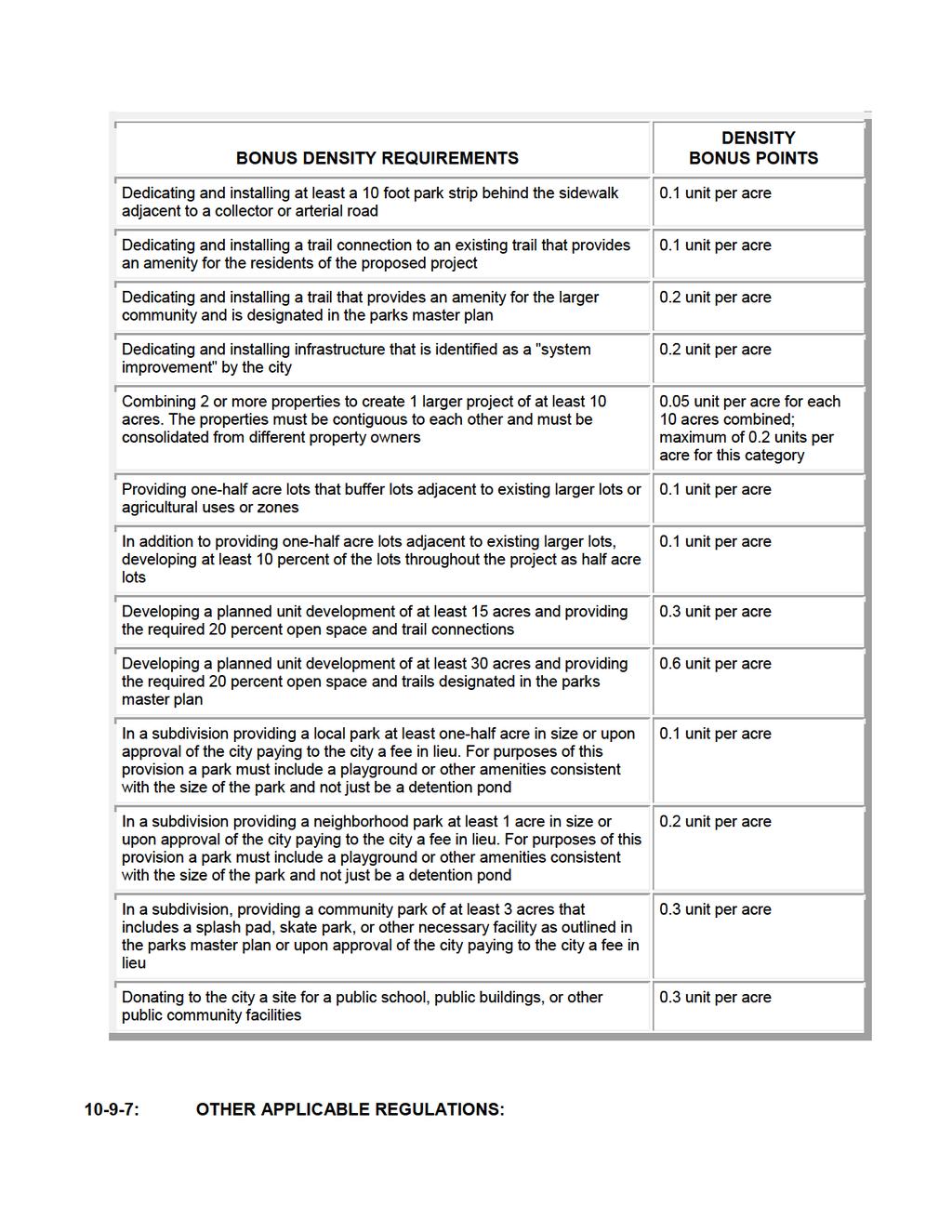
83
84 To the extent that use and development of land located in agricultural zones includes any matter governed by other applicable regulations set forth in this title, such regulations shall apply in addition to the requirements of this chapter.
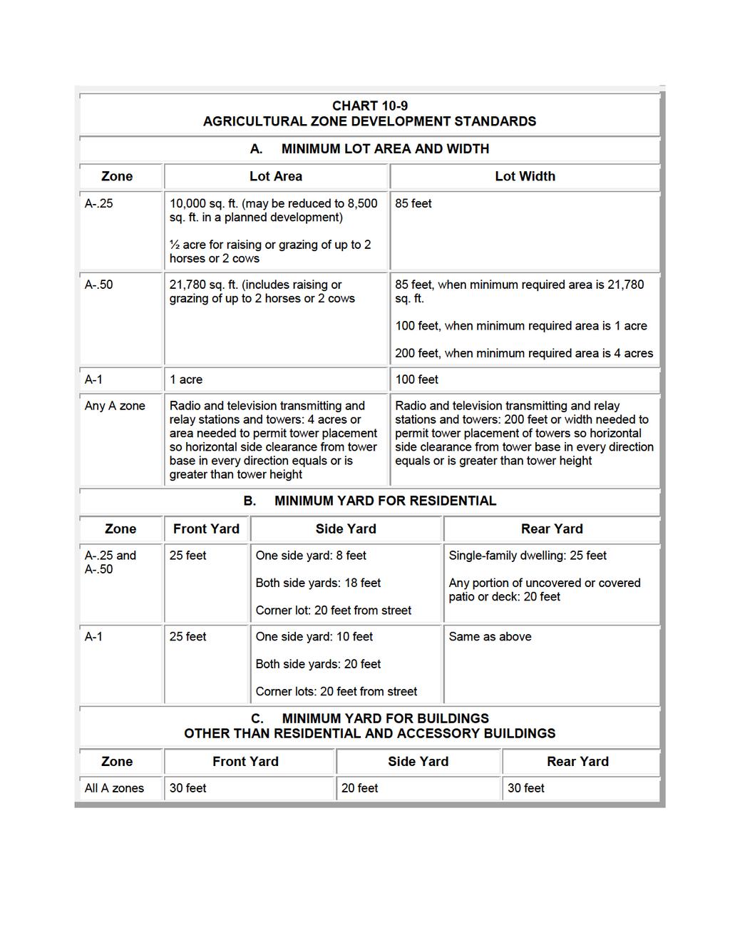
85
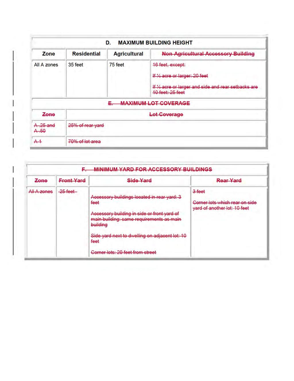
86
87 DRAFT : Purpose : Scope : Definitions : Uses Allowed : Development Approval : Development Standards : Other Applicable Regulations : PURPOSE: Chapter 10 RESIDENTIAL ZONES A. R-1 Zone: The purpose of the R-1 zone is to establish single-family neighborhoods which provide persons who reside therein a comfortable, healthy, safe, and pleasant environment. B. R-2 Zone: The purpose of the R-2 zones is to establish low to medium density residential neighborhoods which provide persons who reside therein a comfortable, healthy, safe, and pleasant environment. C. R-M Zone: The purpose of the R-M zone is to provide areas in the city for high density residential development which provide persons who reside therein a comfortable, healthy, safe, and pleasant environment : SCOPE: The provisions of this chapter shall apply to real property located in a residential zone as shown on the official zoning map : DEFINITIONS: Certain words and phrases in this chapter, including uses, are defined in chapter 3 of this title : USES ALLOWED: A. Permitted And Conditional Uses: Permitted and conditional uses allowed in residential zones shall be as set forth on the Table Of Uses in chapter 16 of this title. Permitted and conditional uses are indicated by "P" or C, respectively. Uses not permitted are indicated by N." B. Accessory Uses: Permitted and conditional uses set forth in chapter 16 on the table of uses shall be deemed to include accessory uses and activities customarily associated with and incidental and subordinate to a permitted or conditional use, subject to applicable provisions of this title, including section C. Prohibited Uses: Any use not shown on the Table Of Uses shall be prohibited unless the community development director determines the use is substantially the same as a permitted or conditional use as provided in section of this title : DEVELOPMENT APPROVAL: The use and development of land located in residential zones shall be approved according to
88 DRAFT applicable administration and development review procedures set forth in chapter 5 of this title : DEVELOPMENT STANDARDS: A. Generally: The use and development of land located in residential zones shall conform to the standards set forth in this section and in chart except as may be authorized by another provision of this title. B. Accessory Structure Design: The front of any accessory structure and any additional portion of the structure viewable from a public street shall have materials and color similar to the primary dwelling. Buildings used for agricultural purposes, such as barns or other such buildings to house animals, and located in a zone which allows Family Food Production, shall not be subject to this requirement. C. Minimum Zone Area: All areas to be zoned R-2-10 or R-2-15 shall be at least 15 acres. D. Dwelling Group Design Criteria: 1. The following requirements shall apply to all dwelling groups: a. The distance between principal buildings and the nearest perimeter lot line shall be at least 15 feet. The distance between the building and a public street shall be at least the front yard required in the zoning district; except, on corner lots, the side yard which faces on a public street shall be at least 20 feet. b. Access shall be provided by a private street or right-of-way from a public street; such private street or right-of-way shall be at least 20 feet wide for one or two rear dwelling units, and at least 30 feet wide for three or more dwelling units. c. No parking areas shall include any part of the required front yard or side yard adjacent to a street. d. Parking areas adjacent to residential uses shall be screened with a six feet high visual barrier. e. Entrances from a private development to a public street shall maintain a "clear view", as defined in section of this title. f. Public access to the dwelling group shall be from a 60 feet or wider street. g. Front and side yards next to a public street shall be landscaped in accordance with applicable provisions of chapter 23 of this title and the following: i. A minimum of two trees per 1,000 square feet of the ground or main floor level. ii. be grouped. One shrub per six linear feet of building foundation. Shrubs may iii. Grass or other plantings installed in all areas not used for building, parking, walks or drives.
89 DRAFT h. A five feet wide landscaped area shall be required between the drive and parking area adjacent to residential property lines. This area shall be planted with a minimum of one tree per 25 feet of linear landscaped area. i. Open space shall be provided on the site equal to 25 square feet per unit in the dwelling group. j. Exterior lighting shall be provided as follows: i. Each parking area shall be illuminated for safety by installing lighting fixtures which emit light at least equivalent to that of one 100-watt incandescent bulb per 100 feet in all directions. ii. residences. All lighting shall be shielded so as not to shine into surrounding k. Residential structures proposed greater than 1 story adjacent to existing single- or two-family dwellings may add one additional floor to the height of the proposed structure for each additional 30 feet increase in rear yard or side yard greater than the 15 feet perimeter yard requirement. l. Buildings which face each other shall be separated by 50 feet or more. Buildings which side on another building shall be separated by 16 feet or more. 2. R-2-10 and R-2-15 Zones: The following additional requirements shall apply to dwelling groups in the R-2-10 and R-2-15 zones. a. The land on which the dwelling group will be erected shall have an area equal to the aggregate of the minimum lot areas otherwise required in the zone for the number of individual dwelling structures in the group. b. A minimum of two parking spaces shall be provided for each dwelling unit. Parking spaces and vehicular maneuvering areas shall meet city standards. c. On any public road where street lighting is not in place, lighting shall be provided at least equivalent to light produced by a 100 watt incandescent bulb per each fifty 50 feet of frontage, or fraction thereof. Lighting is to be provided by a freestanding fixture, in the yard space between the building and public street, or attached to the wall of the building which is not more than 30 feet from the street property line. d. Applications for each building higher than 1 story shall be evaluated on the basis of the proposed building height, mass, materials, spacing and privacy considerations. Harmony and compatibility with existing and future residential structures in the area shall also be evaluated. 3. R-M Zones: The following additional requirements shall apply to dwelling groups in the R-M zone. a. A minimum of two parking spaces shall be provided for each dwelling unit for units with less than three bedrooms and 2.4 spaces for units with three or more
90 DRAFT bedrooms. Additional stalls may be located in designated parking areas. Parking areas associated with a clubhouse or sales center shall have six spaces per 1,000 square feet. Parking spaces and vehicular maneuvering areas shall meet the requirements of chapter 24 of this title. b. If a 6 feet high visual barrier fence is proposed in the yard next to a public street, the barrier shall be placed no closer than 10 feet to the sidewalk. c. Brick, rock, or stone shall be used for the finish system on the front building facade and shall make up a minimum of 15 percent of the total area of the front facades of the complex. If the building incorporates a front porch across the entire front facade of the house, the brick, rock, or stone may be reduced to 10 percent. d. Brick or stone shall be used on the front elevation to show significant masonry architectural detail in the form of vertical accents. However, other architectural details may be used in lieu of brick or stone, if approved by the city. Manufactured materials may be substituted for real stone products. e. The remainder of the front elevation may be finished with a combination of stucco, fiber cement material, or brick products. The use of vinyl and aluminum siding is prohibited. f. Building trim should be applied consistently with the architectural style of the home. Trim should be applied so that it adds dimension to the front facade. g. All finished materials used and their placement on the facade shall be indicated on the elevation rendering when submitted for review to the city. h. When living space is added above a garage, the front facade shall include windows and other treatments to avoid a large blank wall space above the garage doors. i. Driveway locations shall be selected to promote pedestrian friendly pathways. E. Steep Slopes: 1. No development, including clearing, excavation and grading, is permitted where the slope exceeds 30 percent, except roads and trails. The entirety of any areas with slope greater than 30 percent shall remain in natural private or public open space, except as expressly allowed in this section. 2. Slopes over 30 percent may be part of a lot, but may not be included in the building envelope. 3. Roads and other vehicular routes shall not cross slopes greater than 30 percent unless the planning commission determines: a. Appropriate engineering measures can be taken to minimize the impact of the cuts and fills, consistent with the purpose of this chapter; and
91 DRAFT b. The environment and aesthetics of the area will not be significantly affected. 4. Roads shall not cross slopes over 30 percent without review by the planning commission. In no case shall roads cross slopes greater than 50 percent : OTHER APPLICABLE REGULATIONS: To the extent that use and development of land located in residential zones includes any matter governed by other applicable regulations set forth in this title, such regulations shall apply in addition to the requirements of this chapter.
92
93
94
95 Chapter 11 RECREATIONAL ZONES : Purpose : Scope : Definitions : Uses Allowed : Development Approval : Development Standards : Prior Created Planned Unit Developments : Other Applicable Regulations : PURPOSE: A. FR Zone: The purpose of forestry recreation zones is to permit development of canyon and hillside areas for forestry, recreation, and other uses to the extent such development is compatible with protection of the natural and scenic resources of these areas for the continued benefit of future generations. Development in forestry recreation zones is intended to: 1. Allow sensitive and creative development that permits continued enjoyment and protection of such natural areas vital to the attractiveness and economic viability of the city; 2. Support low density, single-family residential for year round and seasonal occupancy; 3. Protect and create recreational opportunities open to the public; and 4. Reflect the natural setting and respect unique site constraints. B. RC Zone: The purpose of the resort community zone is to permit development of areas for resort, recreation, and other uses to the extent such development is compatible with protection of natural and scenic resources of these areas for the continued benefit of future generations. Development in the resort community zone is intended to: 1. Encourage flexible and creative development in order to offer a unique experience in a high quality, visitor friendly setting that contain a complementary mixture of land uses that enhance the experience of the place; 2. Support destination facilities and venues that encourage use by tourists and visitors from outside the city, including commercial and recreational uses; 3. Promote and enhance usable open spaces, recreation sites, outdoor areas, and pedestrian walkability; and 4. Unite varied uses with a consistent theme, appearance, and operations that take advantage of natural assets for public use and recreational potential, yet respect site constraints such as limited access and protection of sensitive and scenic landscapes : SCOPE: The provisions of this chapter shall apply to real property located in a recreational zone as
96 shown on the official zoning map : DEFINITIONS: Certain words and phrases in this chapter, including uses, are defined in chapter 3 of this title : USES ALLOWED: A. Permitted And Conditional Uses: Permitted and conditional uses allowed in recreational zones shall be as set forth on the Table Of Uses in chapter 16 of this title. Permitted and conditional uses are indicated by "P" or C, respectively. Uses not permitted are indicated by N." B. Accessory Uses: Permitted and conditional uses set forth in chapter 16 on the table of uses shall be deemed to include accessory uses and activities customarily associated with and incidental and subordinate to a permitted or conditional use, subject to applicable provisions of this title, including section C. Prohibited Uses: Any use not shown on the Table Of Uses shall be prohibited unless the community development director determines the use is substantially the same as a permitted or conditional use as provided in section of this title : DEVELOPMENT APPROVAL: A. Generally. The use and development of land located in recreational zones shall be approved according to applicable administration and development review procedures set forth in chapter 5 of this title. B. Minimum Zone Area: All areas to be zoned to the forestry residential (FR) zone or resort community (RC) zone shall be at least 15 acres. C. Site Plan Approval: Any development in recreational zones shall be subject to approval of a site plan as provided in section of this title. 1. Site plans shall be prepared by a professionally competent designer or team of designers. 2. Site plans for development in the RC zone shall address each of the requirements set forth in section H in addition to the requirements set forth in section of this title. D. Approval By Other Agencies: Prior to site plan approval of any use in forestry recreational and resort community zones, regardless of size or number of units, the applicant shall provide written evidence from the culinary water authority and the sanitary sewer authority certifying that water and sewer system requirements have been satisfied. The city may also request written evidence of approval from any agency having jurisdiction over the property proposed to be developed. D. Public Support Requirements: The needs of residents in forestry recreation and resort community zones and the challenges of servicing unique sites may require specialized support of various public services. At the discretion of the city, special service districts may be created or required to service these needs. Property owners in forestry recreation zones may therefore be required, to the
97 extent lawfully authorized, to make property available for public facilities and public support operations to service proposed development as follows: 1. Fire/emergency medical services substation; 2. Police substation; 3. Utility substation; 4. Special service districts for water, sewer or public utilities; 5. Road maintenance and erosion control; and 6. Municipal services in general : DEVELOPMENT STANDARDS: A. Generally: The use and development of land located in recreational zones shall conform to the standards set forth in this section and in chart except as may be authorized by another provision of this title. B. Accessory Structures The front of any accessory structure and any additional portion of the structure viewable from a public street shall have materials and color similar to the primary dwelling or structure. Buildings used for agricultural purposes, such as barns or other such buildings to house animals, shall not be subject to this requirement. C. Design Criteria: The following standards shall apply to development in the recreation community zone. 1. The intent of these standards is to: a. Provide for protection of the natural environment and surrounding areas from potentially adverse effects; b. Provide for and protect the unique character, livability and scenic quality of the city and site developed; c. Provide for fire safety and protection of all structures; d. Protect the privacy and quality of life of residents and visitors; e. Ensure consistency in the scale and design of structures; and f. Provide for adequate open space within the development. 2. Structures and open spaces within the resort community developments shall be arranged, as necessary, to assure that adjacent properties will not be adversely affected and that adjacent properties do not have an adverse effect on the resort community. 3. In keeping with the goal of creating a unique outdoor environment and experience, open space and natural areas should be protected to the maximum extent possible.
98 a. At least 20% of the land within a resort community zone shall be preserved as permanent natural open space or provided for otherwise. i. One-half of this permanent open space required shall be maintained in one contiguous lot. ii. Developed recreation amenities, such as pools, courts, or arenas and developed public spaces, such as plazas and courtyards, do not count as open space. iii. Amenities that utilize natural open space, such as trails and golf courses do count as open space. b. A method that is acceptable and approved by the city to maintain open space shall be established prior to sale of any lots. Preservation, maintenance, and ownership of required open spaces within the development shall be accomplished by: i. Dedication of land as a public park or parkway system; ii. Granting a permanent open space easement on or over the private open spaces to the city, another government agency or a nongovernmental organization charged with protecting important landscapes. This is intended to guarantee that the open space remain perpetually in recreational and/or open space use, with ownership and maintenance being the responsibility of the owner or an owners' association established with articles of association and bylaws, which are satisfactory to the city; or iii. Compliance with the provisions of the Utah Condominium Ownership Act, Utah Code , et seq., which provides for payment of common expenses for the upkeep of the common areas and facilities. 4. Plans shall delineate a "limits of disturbance" line to indicate the area within which all disturbance and construction shall be contained. The limits should include the principal structure, accessory structures, utilities, services, drainage facilities, and septic tank. Areas required for driveways and leach fields are not included. In drawing this line, the intention is to minimize visual impacts, prevent erosion, conserve water, and preserve natural vegetation, features, and topography. 5. For the benefit of residents and visitors, the city shall protect access to existing and future recreation areas, such as public lands and trails. The city may request easements through areas proposed for development as needed to permit access. 6. Construction of permanent structures shall not occur in sensitive land areas. Sensitive land areas include: a. Areas with special flood hazard, as provided in title 12 of this code; b. Wetlands, springs or stream corridors;
99 and c. Natural hazard special study areas, as provided in chapter 18 of this title; d. Steep slopes, as provided in subsection H-7 of this section. 7. Steep Slopes: a. No development, including clearing, excavation and grading, is permitted where the slope exceeds 30 percent. All areas with slope greater than 30 percent shall remain in natural private or public open space, except as expressly allowed in this chapter. b. Roads and other vehicular routes shall not cross slopes greater than 30%, unless, after review by the planning commission, it is determined that: i. Appropriate engineering measures can be taken to minimize the impact of the cuts and fills, consistent with the purpose of this section; and ii. The environment and aesthetics of the area will not be significantly affected. c. In no case shall roads cross slopes over 50 percent. 8. Grading shall be minimized to protect existing vegetation and natural drainage patterns, reduce erosion and dust during construction, and to minimize visual impacts. a. Natural drainage patterns shall be maintained to the greatest extent possible. The amount of water runoff currently moving from the project site to adjacent areas shall not exceed preconstruction levels. Alternative stormwater retention is encouraged to minimize runoff. b. Buildings shall be designed to integrate into natural slopes. Mass grading to create a flat building pad is discouraged. c. All cut and fill surfaces shall be regraded to match the surrounding topography as closely as possible. d. All cut and fill surfaces shall be replanted with native plants similar in type to plants that were destroyed. 9. Ridgelines should be retained in a natural state and development near ridgelines should blend with the natural contour of these features. Development near designated ridgelines as designated on the official zoning map should be sited and constructed to avoid creating a silhouette against the sky or backdrop when viewed from three designated vantage points: a West and South; b West and South; and c West and Rose Canyon Road.
100 10. Existing vegetation shall be protected in its natural state to the greatest extent possible. a. All trees over 6 inches in caliper or plants over 10 feet tall shall be noted on plans and marked in the field for the duration of construction. b. All clearing of existing vegetation shall be a conditional use, subject to planning commission approval. Clearing outside the limits of disturbance is discouraged. c. Native compatible trees and vegetation shall be utilized in new landscaping. d. New landscaping shall be designed to minimize the threat of wildfire to built structures. 11. Protecting wildlife and their natural habitat is important for maintaining the natural ecosystem and for the enjoyment of residents and visitors. a. Proposals in the resort community zone shall note important natural features and vegetation that serve as habitat, and identify wildlife that may be present in different seasons. b. Site plans should minimize the impact of development by: i. Siting buildings, structures, roads, trails, and other construction to avoid significant natural features and to maintain a sufficient buffer between these important natural areas and human activity; ii.. Facilitate wildlife movement by designing natural corridors between natural areas and by minimizing fences and road crossings; iii. Maintaining the natural structure of the site, different layers of vegetation; and iv. Revegetating degraded areas with native plants and selecting plants that benefit wildlife for new landscaped areas. 12. Signage in the resort community zone should help unify the development and provide a positive image. a. Signage shall be kept to the minimum necessary to identify destinations and direct people through the development. b. Signage shall be designed as a coordinated signage system for the entire project and should be sensitive to the needs of visitors. c. Signage for the purpose of advertising shall be used to the minimum extent possible and shall be regulated in the development's covenants, conditions, and restrictions. d. Natural materials such as wood, stone, rock and metal should be used.
101 e. Signs shall be illuminated with external, directed lighting. 13. Building Design: a. Buildings shall follow a consistent design theme across the development to unify the resort community. b. Proposed structures shall be complementary to the surrounding landscape in terms of scale, massing, roof shape and exterior materials. c. Buildings shall not create large bulky masses, but should be scaled down into groupings of smaller attached structures. d. Buildings shall be placed on the site and designed to minimize adverse effects on adjacent properties. e. Buildings should be sited so as not to visually break the ridgeline as set forth in subsection C-9 of this section. f. Buildings shall be sited and constructed to resist wildfire. Applicants may be asked to complete a "technical analysis" for the unified fire authority in order to evaluate the safety of a proposal and mitigate safety impacts. g. Except as otherwise specifically provided in this title, all buildings and structures shall meet the following height standards: i. Building heights shall not exceed 35 feet from the lowest finished grade touching the building to the top of the roofline. Where the grade slopes, this dimension shall not be exceeded at any point along the slope. ii. No single-family dwelling structure shall have less than one story above ground. 14. Buildings shall be designed to complement the natural beauty of the surrounding landscape. a. Buildings and accessory structures shall follow a consistent theme, focused on natural materials and colors to blend with the surrounding landscape. b. Wood and stone and other harmonious materials shall be used. The use of bland, unpainted concrete blocks and unpainted metal is prohibited on exterior surfaces. c. Materials, colors and surfaces shall have little or no reflectivity. 15. Circulation networks shall be designed to consider all forms of travel, including, but not limited to, vehicles, bicycles, pedestrians and equestrian use. a. A traffic impact study shall be required to project auto and truck traffic generated by the uses proposed.
102 b. Street widths, materials and configurations should vary depending on the proposed traffic level and need for emergency access. c. Continuous pedestrian and bicycle access shall be provided with minimal barriers to handicapped or elderly persons. 16. Streets, roads, private access roads, driveways, and other vehicular routes shall be designed to minimize the amount of disturbance while allowing safe access. a. Vehicular routes shall not cross slopes greater than 50 percent. b. Vehicular routes shall follow natural contour lines to the greatest extent feasible to minimize cut and fill and disturbance to existing vegetation. c. Driveways shall have a maximum grade of 12 percent. 17. Parking and loading areas shall be designed to accommodate the diverse uses of the resort community zone. a. Parking spaces for residents shall be provided on site to minimize road widths. b. Parking for guest properties shall be provided primarily off street and shall be sufficient to serve those properties. c. Cluster type and shared parking is recommended where feasible. d. Parking areas shall be broken into smaller lots to avoid large expanses of paving. e. Parking lots shall include ample landscaping to buffer them from neighboring properties. f. Areas for loading/unloading of business supplies shall be provided in unobtrusive locations that do not conflict with primary circulation routes. g. Areas for the loading/unloading of vehicles used for recreation, such as trailers, shall be provided as needed. 18. Fences should be used to the minimum extent possible to limit their visual impact and allow access to public areas, as needed. Fences shall conform to the standards set forth in city engineering standards. a. No fence shall be constructed unless shown on an approved site plan. b. No fence in excess of 42 inches in height shall be constructed or installed outside the designated limits of disturbance, except as required by the city for uses such as corrals for permitted animals.
103 c. Fences in front yards and along roadways shall not exceed 42 inches in height. d. Fences shall not inhibit the movement of wildlife along known travel corridors. 19. Lighting shall be limited to promoting safety and visibility, as necessary. Lighting may vary from city standards in this zone, but any variations shall be submitted on a lighting plan for the approval of the city engineer. a. Outdoor lighting shall be shielded or hooded to prevent glare onto adjacent properties and minimize the amount of light directed toward the sky. b. Selective lighting of signs shall be allowed to assist in visibility only. c. A greater number of smaller light fixtures shall be used instead of large, high intensity fixtures. d. Incandescent lights should be used in smaller pedestrian spaces where quality light is especially important. 20. Utilities: All utilities shall be buried underground for protection from natural elements and to be visually unobtrusive. Utility location and service shall be coordinated with the city as needed, as set forth in subsection C of this chapter : PRIOR CREATED PLANNED UNIT DEVELOPMENTS: A. Prior Development: Planned developments in forestry residential zones approved prior to April 2, 2015 which have been constructed pursuant to such approvals, are considered legally conforming. B. New Development: New planned developments shall be prohibited in forestry residential zones : OTHER APPLICABLE REGULATIONS: To the extent that use and development of land located in recreational zones includes any matter governed by other applicable regulations set forth in this title, such regulations shall apply in addition to the requirements of this chapter.
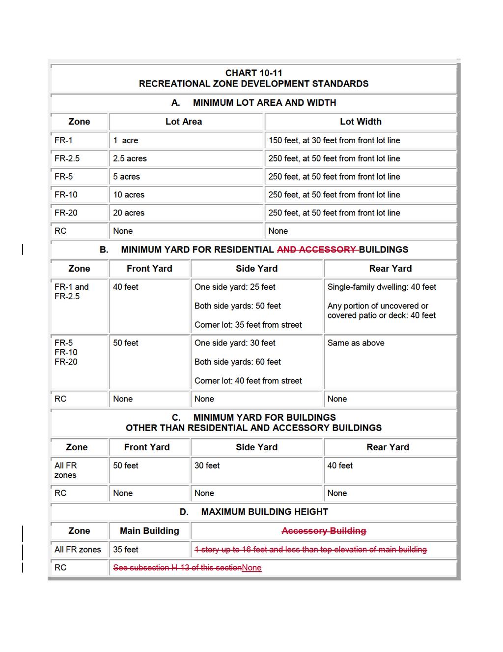
104
105
106 Chapter 29 SUPPLEMENTARY AND QUALIFYING REGULATIONS : Purpose : Scope : Definitions : Abandoned and Junk Vehicles : Accessory Uses And Structures : Adequate Public Facilities : Animals And Fowl : Antenna, Monopole : Antenna, Roof Mounted : Antenna, Wall Mounted : Apiaries : Buildable Area : Building On Legally Created Lot : Bus Shelters : Commercial Short Term Rental Of Dwellings Prohibited : Daycare And Preschools : Easements : Flag Lots : Front Yard Measurement : Front Yard Setback Reduction On Cul-De-Sacs : Gasoline Pump Requirements : Height, Accessory Buildings : Height, Buildings Less Than One Story : Height Measurement, Exceptions, And Limitations : Lots And Parcels Used As One Building Site : Lots And Parcels Created Without Minimum Width And Area : Lots And Parcels Not Meeting Minimum Area And Width : Lot Coverage : Lot, Double Frontage : Lot Grade : Model Home Sales Office : Occupancy Permit : Off Site Improvements : Outdoor Lighting : Private Rights-Of-Way : Public And Quasi-Public Uses : Rear And Side Yard Reduction : Reduction Of Minimum Yard Requirements : Sale Or Lease Of Required Land : Second Kitchen In Single-Family Dwelling : Setback, Deck And Patio : Setback Measurement : Single-Family Or Two-Family Dwellings; Standards : Slope Limits, Driveways : Storage Of Trash And Debris : Subdivision Of Two-Family Dwellings : Swimming Pools : Uses Not Listed; Administrative Determination
107 : Visual Obstructions : Yard Space For One Building Only : PURPOSE: The purpose of this chapter is to provide for the miscellaneous land development regulations which apply throughout the city regardless of zone : SCOPE: The requirements of this chapter shall apply in addition to the development and use standards set forth in other chapters of this title and shall prevail over any conflicting provision of this title unless a different requirement is expressly intended to supersede such provision : DEFINITIONS: Certain words and phrases in this chapter are defined in chapter 3 of this title : ABANDONED VEHICLES: A. Prohibited: Parking or storage of any abandoned, wrecked, or junk vehicle in any zone shall be prohibited except as expressly authorized under this title or this code. B. Exceptions: Notwithstanding the foregoing, storage of vehicles is permitted as follows: 1. One truck, with a capacity of one ton or less, or one automobile which is not currently licensed and registered in this state or another state but is otherwise operable, may be stored on property for two years if it is secured with the windows closed, the trunk and hood closed, and the doors locked, and is not damaged exposing jagged metal. 2. One truck, with a capacity of one ton or less, or one automobile which is inoperable, may be stored in a side yard, except a side yard which faces on a street, or a rear yard on property for two years, provided: a. The automobile or truck is secured with the windows closed, the trunk and hood closed, and the doors locked, and is not damaged exposing jagged metal; b. The automobile or truck is not visible from any public street; and c. The automobile or truck is entirely concealed by a covering which is maintained in good condition and which does not extend closer to the ground than the lowest point of the vehicle body. 3. All existing legal nonconforming motor vehicles as of the effective date hereof, or any amendment hereto, shall comply with the provisions of this subsection within one year from the date of the enactment or any amendment thereto : ACCESSORY USES, BUILDINGS, AND STRUCTURES:
108 A. Permitted. Accessory uses, buildings, and structures shall be permitted in all zones provided they are incidental to, and do not substantially alter a principal use or structure, subject to the provisions of this section and the zone where they are located. No accessory use, building, or structure shall be allowed on a lot unless a permitted or conditional use exists on the same lot. B. Front Yard. No accessory building or structure shall be located in a front yard unless expressly authorized by a provision of this title. C. Side Yard: 1. In all A and R 1 zones, garages and other accessory buildings located in a rear yard shall have a minimum side yard of at least 3 feet. If located in the side or front yard of a main building, the accessory building shall meet the side and front yard requirements applicable to the main building. If the building is located adjacent to the side yard of a dwelling on an adjoining lot, the building shall be at least 10 feet from property line. On corner lots, the side yard shall be 20 feet from the public street. 2. In all R 2 zones, the minimum side yard requirement for an accessory building which is in a rear yard shall be 3 feet. D. Rear Yard: 1. In all A and R 1 zones, the minimum rear yard for accessory buildings shall be 3 feet except that on corner lots which rear upon the side yard of another lot, accessory buildings shall not be closer than 10 feet to such side yard. 3 feet. 2. In all R 2 zones, the minimum rear yard for an accessory building shall be E. Size and Lot Coverage: On lots under one half acre, an accessory building shall not exceed 800 square feet or cover more than 25 percent of the rear yard. On lots one half acre or larger, no accessory building or group of accessory buildings shall cover more than 25 percent of the rear yard. F. Height: Accessory buildings shall have a maximum of 16 feet in height, except: 1. On lots one half acre or larger, an accessory building may have a maximum height of 20 feet. 2. On lots one half acre or larger, an accessory building may have a maximum height of 25 feet if the side and rear setbacks for the building are at least 10 feet : ADEQUATE PUBLIC FACILITIES:
109 Land shall be developed only where existing infrastructure is in place or will be timely provided to service proposed development. The city may require an analysis to be completed to determine whether adequate public facilities are available to service a development and whether such development will change existing levels of service or will create a demand which exceeds acceptable levels of service for roadways, intersections, bridges, storm drainage facilities, water lines, water pressure, sewer lines, fire and emergency response times, and other similar public services. The city may disapprove a proposed development if demand for public services exceeds service levels adopted by the city. No subsequent approval of such development shall be given until either the developer or the city installs improvements calculated to raise service levels to the standards adopted by the city : ANIMALS AND FOWL: A. Permitted For Family Food Production: The keeping of animals and fowl is allowed as set forth in the chart below in zones where family food production is a permitted use or conditional use. 1. The number of animals and fowl may be doubled temporarily if the increase is related strictly to meat or milk production, or for a bona fide youth project such as 4-H and fair projects. 2. The keeping of more animals and fowl than listed in the chart or allowed temporarily for meat or milk production may be approved in zones where family food production is allowed as a conditional use. 3. Small animals and fowl shall be rabbits, chickens (including hens and pullets but excluding roosters), pheasants, ducks, and pigeons. Medium animals and fowl shall be sheep, goats, turkeys, geese, and miniature horses. Large animals shall be cows, horses, and alpaca. 4. The keeping of animals and fowl shall conform to good animal husbandry practices including, but not limited to, mitigation of noise, smells, insects, rodents, dust, or other nuisances resulting from the keeping of animals and fowl. 5. No animals or fowl described in subsection A shall be kept or maintained closer than 40 feet from any dwelling on an adjacent parcel of land, and no barn, stable, coop, pen, or corral shall be kept closer than 40 feet from any street. Zone A-.25 A-.50 A-1 R-1-21 R-1-43 Lot Size.49 Acre Or Less.5 Acre To 99 Acre Per 1 Acre + Permitted: 40 small animals and 2 medium animals Permitted: 75 small animals, 4 medium animals, and 2 large animals Permitted: 100 small animals, 15 medium animals, and 4 large animals B. Foster Animals: Owners of dogs and cats may obtain a permit to keep more than three dogs or cats in a residential zone provided that: 1. Only one dog or one cat with unweaned puppies or kittens shall be kept at a time;
110 2. Such animal shall be the property of a local public animal shelter or an internal revenue code section 501(c)(3) animal welfare organization; 3. Such pets are awaiting adoption; 4. Approval is granted by the health department; 5. Adequate areas for confinement and shelter are provided; 6. No pet or premises is deemed to be a nuisance; 7. The animal shall be kept for no more than six months; and 8. A foster animal permit is obtained from Salt Lake County animal control. C. Fancier Permit: Owners of dogs and cats may obtain a permit to keep more than three dogs and cats in a residential zone provided that: 1. Each animal is registered with a national registry and eligible for licensing by Salt Lake County animal services; 2. Approval is granted by the city and Salt Lake County animal services; and 3. Adequate areas for shelter and confinement are verified. D. Hobby Permit: Owners of dogs and cats may obtain a permit to keep more than three dogs, cats, or ferrets in a residential zone provided that: 1. Each animal is rendered sterile and individually licensed; 2. Approval is granted by the city and Salt Lake County animal control; and 3. Adequate areas for shelter and confinement are verified. E. Exotic Animal Permit: Any person, over 18 years of age, may obtain an exotic animal permit upon: care, 1. Demonstrating sufficient knowledge of the species to provide adequate 2. Providing proof of adequate caging; 3. Providing proof that the animal poses no threat to the health and safety of the community in the event the animal should escape, and 4. Providing proof of any required state or federal license : ANTENNA, MONOPOLE:
111 In addition to the other provisions of this title, monopoles are allowed in the zones in which they are listed, subject to the provisions set forth in this section: A. Monopoles shall be constructed so as to allow a collocation of a second user on the base or original pole. B. The height of the pole shall be limited to 50 feet above grade, unless approved by the planning commission for a greater height, but in no case greater than 100 feet above grade. C. The distance between a monopole and a residential structure shall be at least 150 feet unless the planning commission determines a greater distance is necessary to meet the requirements for approval of a conditional use permit, when the monopole is authorized as a conditional use. D. The applicant shall submit images or drawings of a proposed monopole to show what it will look like when built. The images or drawings shall show two vantage points as determined by the community development director. E. Property owners within 600 feet of a monopole shall be given notice of the public meeting before the planning commission to consider approval of a conditional use permit. F. Every effort should be made to keep a monopole 100 feet from a public street. G. Each telecommunication company requesting a monopole shall submit a general master plan of the proposed number of poles projected within the city limits over the subsequent three years. H. A monopole and the site the pole occupies shall be properly maintained. The pole shall be removed within 60 days after the communications use is discontinued. I. Monopoles may be required to be designed to blend into their surroundings : ANTENNA, ROOF MOUNTED: A. Where Permitted, Conditional: Roof mounted antennas shall be a permitted use in commercial, office, and industrial zones, and a conditional use in all other zones. B. Appearance: Roof mounted antennas shall be constructed, painted, or fully screened to match as closely as possible the color and texture of the building and wall on which it is mounted. C. Screening: Roof mounted antennas may be mounted on the top of existing penthouses or mechanical equipment rooms if the antennas and antenna support structures are enclosed or visually screened from view. Screening structures may not extend more than 8 feet above the existing roofline of the penthouse or mechanic equipment room. D. Distance; Height: Antennas not mounted on a penthouse or mechanical equipment room shall be mounted at least five feet back from the exterior wall of the building. The maximum height of an antenna mounted between five feet and 10 feet back from the
112 exterior wall shall be directly proportional to the setback distance, and may not exceed 10 feet above the roofline of the building. Antennas shall be mounted at least five feet behind any parapet wall. An antenna may not exceed more than 15 feet above the roofline of the building itself, except as allowed as a conditional use. Similarly, a roof mounted antenna may not extend above the roofline of a penthouse or mechanical equipment room, except as allowed as a conditional use : ANTENNA, WALL MOUNTED: A. Where Permitted, Conditional: Wall mounted antennas shall be a permitted use in commercial, office, and industrial zones, and conditional use in all other zones. B. Size: Wall mounted antennas may not extend above the wall line of the building or extend more than four feet horizontally from the face of the building. C. Appearance Of Supporting Structures: Antennas, equipment, and the supporting structures shall be painted to match the color of the building or structure, or the background against which they are most commonly seen. Antennas and supporting structures on the building shall be architecturally compatible with the building. D. Mounted Antennas: Antennas mounted directly on existing walls, penthouses, or mechanical equipment rooms shall be deemed a wall mounted antenna if no portion of the antenna extends above the roofline of those building structures : APIARIES: An apiary is allowed in any zone which allows single-family residential, with the following requirements: A. Lots may contain two hives per 10,000 square feet, but not more than four hives or equivalent capacity. Hives shall be located in the side or rear yard. B. If required by state law, each beekeeper shall be registered with the Utah department of agriculture and food. C. Honeybee colonies shall be kept in hives with removable frames which shall be kept in sound and usable condition. D. Hives shall be placed at least five feet from any property line and six inches above the ground, as measured from the ground to the lowest portion of the hive, provided, however, that this requirement may be waived if permission is attained in writing by the adjoining property owner. Act. E. Hives shall be operated and maintained as provided in the Utah Bee Inspection F. Each hive shall be conspicuously marked with the owner's name, address, telephone number, and state registration number, if any.
113 G. Each beekeeper shall ensure that a convenient source of water is available to the colony continuously between March 1 and October 31 of each year. The water shall be in a location that minimizes any nuisance created by bees seeking water on neighboring property. H. A fence may be required upon complaint from the neighbor : BUILDABLE AREA: Every lot created after the effective date of this title shall have a buildable area sufficient to place a building or structure thereon which meets the minimum standards of the zone where the lot is located. Buildable area shall be required to be depicted on a proposed subdivision plat, site plan, or plot plan for the purpose of notifying future owners of the approved buildable area based on applicable development standards. Area within an easement may not be included within buildable area unless the easement beneficiary executes and records a release of the easement in a form acceptable to the city attorney : BUILDING ON LEGALLY CREATED LOT : A. Legal Lot: Every building, including a dwelling, shall be located and maintained on a legally created lot as defined in this title, unless such lot is a legally nonconforming lot. B, Number Of Single Family Dwellings On One Lot: Not more than one single family dwelling shall occupy a lot except as authorized by the provisions of this title : BUS SHELTERS: Bus shelters authorized by the state transit authority and sited with approval of affected property owners, if any, and the planning commission, may be placed within the front yard setback required in the zone in which the shelter is located : COMMERCIAL SHORT TERM RENTAL OF DWELLINGS PROHIBITED: It shall be deemed a commercial use and unlawful to lease or rent any dwelling or portion thereof located within any agricultural or residential zones for lodging or accommodation purposes for a period less than 30 consecutive days, except as specifically allowed in the R-M zone : DAYCARE AND PRESCHOOLS: A "daycare/preschool center," as defined in chapter 3 of this title, shall be subject to the following conditions: A. Compatibility: A daycare/preschool center located within an existing building shall be compatible with existing and proposed land uses located on the same lot. New construction shall be compatible in design and scale of building with existing development within the same area. B. State Approval: A daycare/preschool center shall be approved as required by the state department of social services.
114 C. Parking: Parking, pickup, and delivery areas shall be provided as required by chapter 24 of this title. E. Frontage: In any zone, except the R-M, C-1, C-2, or M-1 zones, the lot on which a daycare/preschool center is located shall have frontage on a street with an existing right-ofway of 80 feet or greater. F. Home Occupation: A home daycare/preschool shall meet the home occupation requirements set forth in chapter 22 of this title and the following additional requirements: 1. The operator shall be a bona fide resident of the premises where the home occupation is conducted. 2. The number of children attending a daycare or preschool center shall conform to applicable requirements of the Utah code. 3. Outdoor play areas shall be fenced and located only in a rear yard or side yard. No play or yard equipment shall be located in the front yard. 4. Notwithstanding subsection C, no additional parking or drop-off area shall be created. 5. A daycare or preschool center operated as a home occupation shall be prohibited if located on a shared driveway EASEMENTS: A. Acknowledgment Required. No dwelling, main building, or permanent accessory building shall be located within a recorded easement area unless the property owner either produces evidence satisfactory to the community development director that the easement has been abandoned, or executes a recordable document, in a form approved by the city attorney, acknowledging that notwithstanding apparent abandonment of the easement, the structure may be subject to the superior interest of the easement holder and may be required to be relocated at the property owner s expense to accommodate such interest. B. Location. Any structure in an easement area shall be located pursuant to the setback and other applicable requirements of this title. C. No Change In Legal Rights. Nothing in this section is intended to expand or restrict the rights or obligations of any party to any recorded easement : FLAG LOTS: A. Purpose: Flag lots are intended to apply only to exceptionally deep or odd shaped parcels that are isolated from public streets and would be difficult to develop or utilize in any other way. An applicant shall demonstrate that a flag lot is the most appropriate development option and that it will not detract from the surrounding neighborhood. B. Minimum Requirements: A flag lot shall meet the following minimum requirements:
115 1. The staff portion of a flag lot shall front on and be contiguous to a dedicated local public street. Flag lots shall not front on a collector or arterial street. 2. The minimum width of the staff portion of a flag lot shall be 20 feet. On properties where the length of the staff is greater than 150 feet, the width of the staff shall be no less than 25 feet of drivable surface unless otherwise recommended by the city engineer and fire marshal and approved by the planning commission. 3. The maximum length of a flag lot shall be 220 feet unless otherwise approved by the planning commission upon recommendation of the unified fire authority. 4. The flag lot shall have a hard surfaced driveway from a public street to the required parking area for the flag lot. Adequate provisions shall be made for drainage of the driveway such as curb and gutter, berming, or swales. 5. A flag lot shall not be created as part of a subdivision where there are more than two lots in the subdivision or from an illegally divided lot or parcel. 6. A flag lot shall not gain access via an easement on an adjacent property. 7. No building or construction, except for driveways, shall be allowed on the staff portion of a flag lot unless the minimum width thereof is the same or greater than the minimum width for a lot as allowed by the zone in which the flag lot is located (excluding entrance features and streetlights). 8. The front side of the flag portion of a flag lot shall be deemed to be that side nearest to the dedicated public street upon which the staff portion fronts, unless otherwise determined by staff on a case by case basis. 9. The staff portion of a flag lot shall be deemed to end, and the flag portion of the lot shall be deemed to commence, at the extension of the front lot line. 10. The square footage of a flag lot shall be at least one-half acre. The square footage located in the flag portion of the lot, which shall be exclusive of the square footage located in the staff portion of the lot, shall be at least one-third acre. 11. The front, side, and rear yard requirements of the flag portion of a flag lot shall be the same as required by the zone in which the lot is located. 12. Only one single family dwelling shall be allowed on a flag lot. 13. The approved building envelope of a flag lot shall be illustrated upon the final subdivision plat. 14. A six foot solid vinyl fence shall be installed on all sides of a flag lot, including along both sides of the staff portion of the lot, subject only to the requirements of section of this title regarding front yard fencing. 15. All applicable street improvements, including curb, gutter, and sidewalk, shall be installed along the front of both the flag lot and the lot or parcel from which it is being subdivided : FRONT YARD MEASUREMENT:
116 When a front yard is required for a lot facing on a street for which an official map has been recorded, the depth of such front yard shall be measured from the mapped street line shown on the official map : FRONT YARD SETBACK REDUCTION ON CUL-DE-SACS: When a front yard is adjacent to the circle of a cul-de-sac, the setback for a main building may be reduced to 22 feet : GASOLINE PUMP REQUIREMENTS: A. Setback Requirements: Gasoline pumps shall be set back not less than 18 feet from any street line to which the pump island is perpendicular and 12 feet from any street line to which the pump island is parallel, and not less than 10 feet from any residential zone boundary line. If the pump island is set at an angle on the property, it shall be so located that vehicles stopped for service will not extend over the property line. B. Canopies: Canopies constructed to provide a weather shield over gasoline pump islands shall be set back not less than six feet from any street line and not less than 10 feet from any residential zone boundary : HEIGHT, ACCESSORY BUILDINGS: No building which is accessory to a single-family, two-family, three-family, or four-family dwelling shall exceed 16 feet in height, except in the A-1, A-.5 and A-.25 zones on lots one-half acre or larger, the accessory building may be a maximum of 20 feet in height : HEIGHT, BUILDINGS LESS THAN ONE STORY: No building shall be erected to a height less than one story above grade : HEIGHT MEASUREMENT, EXCEPTIONS, AND LIMITATIONS: A. Height Measurement. 1. Except as provided in subsection A 2, allowable height shall be the vertical distance from finished grade to the highest point of the building or structure. 2. For sloped lots or buildings with varied floor elevations, the height of a building shall be the vertical distance from the average elevation of the ground under the building to the allowed number of feet above and parallel to the finished grade. The average level of ground shall be determined by adding the elevation of the highest and lowest foundation points of the building and dividing by two (the midpoint of foundation). BA. Height Exceptions: The following may be erected above the height limits prescribed in this title: 1. Penthouse and roof structures for elevators, stairways, tanks, ventilating fans, or similar equipment required to operate and maintain a building, and
117 2. Fire or parapet walls, skylights, towers, steeples, flagpoles, chimneys, smokestacks, water tanks, wireless or television masts, theater lofts, silos, and similar structures. CB. Height Limitations: 1. No space above the height limits prescribed in this title shall be allowed for the purpose of providing additional floor space. 2. The height limits prescribed in this title shall not be exceeded in any area governed by airport height provisions. CD. Agricultural Structures: Agricultural structures may have less than one story : LOTS AND PARCELS USED AS ONE BUILDING SITE: When a common side lot line separating two or more contiguous lots is covered or proposed to be covered by a building, such lots shall constitute a single building site and the setback requirements of this title shall not apply to the common lot line if a document is recorded indicating the owner s intent to use the combined lots as a single development site. The setback requirements of this title shall apply only to the exterior side lot lines of the contiguous lots so joined : LOTS AND PARCELS CREATED WITHOUT MINIMUM WIDTH AND AREA: No lot which has less than the minimum width and area requirements for the zone in which it is located may be created except within a planned development or as authorized by a duly granted variance or other provision of this title : LOTS AND PARCELS NOT MEETING MINIMUM AREA AND WIDTH: Minimum lot area and width requirements of this title shall not be construed to prevent the use of a lot for a single-family dwelling so long as such lot was held in separate ownership on the effective date of this title; and was legally created when it became nonconforming as to the minimum area or width : LOT COVERAGE: A building or group of buildings and associated accessory buildings shall conform to the lot coverage requirements of the zone in which they are located. If such zone has no lot coverage requirement, then such buildings shall not cover more than 50 percent of the area of the lot on which they are located : LOT, DOUBLE FRONTAGE: A lot having frontage on two or more streets shall be prohibited except for corner lots and double frontage lots in subdivisions which abut an arterial or collector street shown on the city s master street plan. A. Access: Double-frontage lots shall be accessed only from an internal subdivision street.
118 B. Lots With More Than One Front Lot Line: Frontage on lots having a front lot line on more than one street shall be measured on one street only : LOT GRADE: A. Grade At Property Line: The grade of a lot along a property line shall be: 1. The grade shown on an approved subdivision grading plan; or 2. The naturally occurring grade. B. Grade From Property Line: The grade of a slope from a property line shall not exceed 25 percent except as permitted by a variance approved under section of this title : MODEL HOME SALES OFFICE: A. Street Paving: Model units shall not to be used until streets are paved. B. Parking: Parking shall be in designated parking areas only. C. Signage: Signage shall conform to the requirements of chapter 27 of this title. D. Hours Of Operation: Operating hours shall be between be 9 A.M. to 8:30 P.M. E. Restoration: The unit shall be converted back to a dwelling within 120 days after the last unit within the project is sold. F. Lighting: Lighting shall be low level and compatible with a residential area. G. Business Activity: The activity conducted within a model home shall be sales only; and not related to construction or production : OCCUPANCY PERMIT: A. Compliance: Land, buildings, and premises in any zone shall hereafter be used only for purposes authorized by this title in such zone and in accordance with the regulations established for the zone. B. Issuance: An occupancy permit shall be issued by the community development director to the effect that the use and/or building or premises conforms to the provisions of this title and related ordinances prior to the occupancy of any building hereafter erected, enlarged, or structurally altered, or where any vacant land is hereafter proposed to be occupied or used. C. Change Of Use: Such a permit shall also be issued whenever the character or use of any building or land is proposed to be changed from one use to another use. D. Verification Request: Upon written request from the owner, such a permit shall also be issued covering any lawful use of a building or premises existing on the date of city incorporation.
119 : OFF SITE IMPROVEMENTS: A. Off Site Improvements Required: The applicant for a building or conditional use permit for all dwellings within an approved subdivision, commercial or industrial uses, and all other business and public and quasi-public uses, shall provide curb, gutter, and sidewalk along the entire property line which abuts any public road or street in cases where it does not exist at city standards. 1. Vehicular entrances to the property shall be approved by the community development director. 2. Height, location, structural specifications, maximum and minimum cut radius and minimum roadway approach angles to the centerline of the street are subject to the approval of the agency concerned. B. Fee In Lieu Of Improvements: 1. Where conditions exist which make it unfeasible or impractical to install such curb, gutter, and sidewalk, the applicant may, in lieu of providing the improvements, pay to the city a fee equal to the estimated cost of such improvements, as determined by the community development director. Upon payment of such fee by the developer, the city shall assume the responsibility for future installation of such improvements. 2. The city treasurer shall place such fees in a special account, and shall credit to such account a proportioned share of interest earned from investment of city monies. Records relating to identification of properties for which fees have been collected, fee amounts collected for such properties, and money transfer requests, shall be the responsibility of the community development department OUTDOOR LIGHTING: A. General Provisions. Outdoor lighting fixtures shall be arranged to direct light away from adjoining residential property. 1. Lighting fixtures mounted on utility poles shall be fully shielded, cut-off type fixtures that will not allow light dispersion or direct glare to shine above a 90 degree horizontal plane from the base of the fixture. 2. Detached lighting of signs, buildings and displays shall be directed downward. Uplighting shall be prohibited except as allowed in landscaped areas as part of an approved site plan, conditional use permit, or other plan or permit. 3. Electrical service to outdoor lighting fixtures shall be underground unless fixtures are mounted directly on utility poles. B. Exemptions. The following types of outdoor lighting shall be exempt from the provisions of this section: 1. Holiday lighting during the months of November, December, and January,
120 provided such lighting does not create dangerous glare on adjacent streets or property; 2. Temporary lighting for temporary uses approved as part of a temporary use permit pursuant to section of this title; 3. Lighting associated with agricultural operations; 4. Construction or emergency lighting, provided such lighting is temporary and is discontinued when the need for such lighting ends; and 5. Roadway lighting PRIVATE RIGHT-OF-WAY: The community development director shall not authorize a building permit for a dwelling located on a lot accessed only by a private right-of-way except under one of the following conditions: A. Nonconforming Lot. The lot was legally created and recorded prior to the effective date of this title. B. Variance. A variance is granted by the appeal authority. C. Planned Development or Condominium. The lot is part of an approved planned development or condominium : PUBLIC AND QUASI-PUBLIC USES: A. The requirements of this title as to minimum lot area and minimum yards may be reduced by the planning commission for a public use. The planning commission shall not authorize a reduction in the lot area or yard requirements unless the evidence presented is such as to establish that the reduction will not, under the circumstances of the particular case, be detrimental to the health, safety, or general welfare of persons residing or working in the vicinity, or injurious to property or improvements in the vicinity. B. All facades, including back and side elevations of a public or quasi-public building generally visible from public view or adjacent to residential areas, shall have an element of rock or stone. The type and amount of rock or stone shall be approved by the planning commission : REDUCTION OF MINIMUM YARD REQUIREMENTS: Any lot under separate ownership from adjacent lots and recorded before the effective date of this title which has a smaller width than required by the zone in which the lot is located, shall be deemed a buildable lot as follows: A. Interior Lots: For interior lots, the smaller of the 2 side yards is at least five feet wide and the other side yard is at least 8 feet wide. B. Corner Lots: For corner lots, the street side yard is at least 15 feet wide and the other side yard is at least five feet wide.
121 : SALE OR LEASE OF REQUIRED LAND: No land needed to meet the size, width, yard, area, coverage, parking or other requirements of this title for a lot shall be sold, leased, or otherwise transferred away from such lot, whether by subdivision lot line adjustment or metes and bounds, so as to create or increase a nonconformity except as may be allowed by this title or state law : SECOND KITCHEN IN A SINGLE-FAMILY DWELLING: A. Approval of a second kitchen within a single-family dwelling unit shall not be an approval of a second dwelling unit or accessory dwelling unit. B. A second kitchen in a single-family residence (dwelling unit) may be allowed as a permitted use in the zones in which they are listed if all of the following requirements are met: 1. The residence shall have only one front entrance. 2. The residence shall have only one address. 3. An interior access shall be maintained to all parts of the residence to assure that a secondary unit or apartment is not created. There shall be no keyed and dead bolt locks or other manner of limiting or restricting access from the second kitchen to the remainder of the residence. 4. The residence shall have no more than one electrical meter. 5. The residence shall have no more than one water, and one sewer hookup. 6. A second kitchen shall exist only as part of the primary structure and shall not be installed in an accessory building. 7. Once a second kitchen is approved under the above criteria, both present and future owners of the residence shall limit use of the single-family residence to a family only. No roomers or boarders shall be permitted. 8. Construction of any such kitchen shall meet standards of the current construction codes adopted by the city. B. Occupancy Limitation. When a second kitchen is approved pursuant to subsection A. of this section, both present and future owners of the premises shall limit the use of the dwelling unit to family occupancy only and no roomers or boarders shall be permitted. Such limitation shall not apply if the second kitchen is part of an approved accessory apartment. C. Inspections. Upon request by the city, the dwelling owner shall allow inspection of the dwelling unit at reasonable times to determine compliance with this section : SETBACK, DECK AND PATIO: Any part of a deck or patio covered with a roof or enclosed on two or more sides, or
122 which exceeds 3 feet in height at any point above finished grade shall conform to applicable yard setback requirements : SETBACK MEASUREMENT: The depth of a required yard abutting a street shall be measured from the lot line except as set forth below: A. Blocks With Nonconforming Setbacks: In blocks where more than 50 percent of the buildable lots have main buildings which do not meet the current front yard setback of the zone in which the block is located, the minimum front yard requirement for new construction shall be equal to the average existing front yard size on the block. B. Proposed Streets: Whenever a front, side, or rear yard abuts a public street proposed to be constructed or widened as shown on the master street plan or official map, the depth of such yard shall be measured from a line which is one-half of the proposed right-of-way width from the center line of the street to be constructed or widened, or from the current lot line, whichever is greater : SINGLE-FAMILY ATTACHED OR DETACHED DWELLINGS; STANDARDS: Any detached or attached single-family dwelling located on an individual lot, except within a mobile home park or mobile home subdivision, shall meet the off-street parking requirements in chapter 24 of this title, and the following standards in addition to any others required by law, except as provided in subsection H of this section: Attached single family dwellings includes, but is not limited to, two-family dwellings, three-family dwellings, four-family dwellings, townhomes, or other similar type units. A. Exterior Materials: Exterior materials for all buildings shall include brick, stucco, stone, or other decorative masonry products including fiber-cement siding as approved by the planning commission. A minimum of 40 percent of the front exterior and any side or rear viewable from the street shall be brick or stone. Vinyl and wood siding are not permitted. However, shake shingles may be permitted as an accent material as approved. All sides of dwellings shall receive equal design consideration, particularly where they may be readily viewed by pedestrians and motorists, or from adjacent properties. B. Review Of Building Colors And Materials: Building colors and materials shall be reviewed by the planning commission at the time of subdivision approval. A materials board shall be submitted with each subdivision application. C. Garages: Dwellings shall include a minimum two car garage (minimum 24 feet by 22 feet, or approximate approved equivalent). D. Parking: The driveway shall be a minimum of 24 feet in length. E. Minimum Floor Area: The minimum total floor area, finished and unfinished, of any single-family dwelling shall be 2,400 square feet. F. Roof Pitch: Main buildings shall be constructed with minimum 5:12 roof pitch.
123 G. Building Elevations: Building elevations shall vary so that the same house is not built within 3 lots or across the street from the same elevation. H. Deviations: The planning commission may approve deviations from one or more of the developmental or architectural standards provided in this section on the basis of a finding that the architectural style proposed provides compensating design features SLOPE LIMITS, DRIVEWAYS: No driveway shall exceed a slope of 12 percent. When a driveway slopes downward from a street, the driveway shall be designed to prohibit surface water drainage from entering a building : STORAGE OF TRASH AND DEBRIS: No yard or other open space shall be used for the accumulation of trash, debris, or abandoned equipment and no land shall be used for such purposes, except as authorized by and in compliance with the provisions of this title : SUBDIVISION OF TWO-FAMILY DWELLING: Upon certification by the community development director, a legal existing or proposed two-family dwelling may be divided into attached single-family dwellings by subdividing the lot. Each dwelling shall have a minimum lot area equal to one-half of the minimum lot area required in the zone for a two-family dwelling, which in no case shall be less than 4,000 square feet, and shall meet all building, fire, health, parking and other requirements for a single-family dwelling. An application for lot division certification shall be accompanied by a site plan showing buildings, landscaping, parking, and any other information deemed necessary by the community development director. The community development director may attach conditions to certification consistent with the purpose of this title. Such division of a lot shall not be deemed a subdivision of land : SWIMMING POOLS: Swimming pools of permanent construction not enclosed within a building shall be set back at least five feet from all property lines and shall be completely surrounded by a fence or wall having a lockable self-closing gate and a height of at least six feet which conforms to building code requirements. If the applicable building code has a different requirement, such requirement shall prevail over this section : USES NOT LISTED; ADMINISTRATIVE DETERMINATION: Determination as to the classification of uses not specifically listed or interpretation of uses listed in this title shall be made by the community development director as provided in section of this title : VISUAL OBSTRUCTIONS: To avoid creating a visual obstruction and promote public safety, a fence, wall, sign, or other similar structure or landscaping located in a required front yard shall meet the following requirements:
124 A. Driveway: No sight-obscuring fence, wall, sign, or other similar structure, or landscaping which exceeds two feet in height shall be placed within a triangular area formed by a driveway line, the street property line, and a line connecting them at points 12 feet along the driveway line and 12 feet along the street curb line, except for a reasonable number of trees pruned high enough to permit unobstructed vision for drivers of motor vehicles. B. Clear View of Intersecting Street. In all zones, no sight-obscuring fence, wall, sign, or other similar structure, or landscaping which exceeds two feet in height shall be placed on any corner lot within a triangular area formed by the street property lines and a line connecting them at points 30 feet from the intersection of the street lines, except for public safety signs and equipment. Tree canopies pruned to seven feet above grade are permitted provided no tree trunk shall be located inside the clear-view area : YARD SPACE FOR ONE BUILDING ONLY: No required yard or other open space around an existing building, or which is hereafter provided around any building for the purpose of complying with the provisions of this title, shall be considered as providing a yard or open space for any other building; nor shall any yard or other required open space on an adjoining lot be considered as providing a yard or open space on a lot whereon a building is to be erected or established. This section shall be so construed to mean only one main building may be permitted on a lot unless otherwise provided in this title.

125 Date of Meeting: 07/19/2018 File # Z Applicant Herriman City Address Request Text Change to the Land Development Code Chapter 16, Table of Uses

126 Staff Report DATE: July 6, 2018 TO: FROM: Planning Commission Bryn McCarty, AICP, Assistant City Planner MEETING: Planning Commission July 19, 2018 REQUEST: Text Change to the Land Development Code Chapter 16, Table of Uses Applicant: Herriman City File Number: Z Request Herriman City is proposing a text change to Title 10 of the Herriman City Code, which is the Herriman Land Development Code, regarding Chapter 16 Table of Uses. Notice The City posted the public hearing notice in the newspaper and on the Herriman City website on July 9, As of the date of this report, staff has not received any public comments regarding the proposed text change. Process A text change is a legislative action. The Planning Commission holds a public hearing and makes a recommendation to the City Council. The City Council will then hold a public meeting to discuss the item and make the final decision. Discussion In December 2017, the City adopted a new Land Development Code. At that time, the Planning Commission (PC) directed staff to make several updates to the permitted and conditional uses listed in each zone. Staff has conducted several work meetings with the PC to review Chapter 16, the Table of Uses, and make revisions. Staff has attached the revised text for review and recommendation to the City Council. Recommendation Staff recommends approval of the proposed text changes to Chapter 16 the Table of Uses. Attachments A. Proposed Text
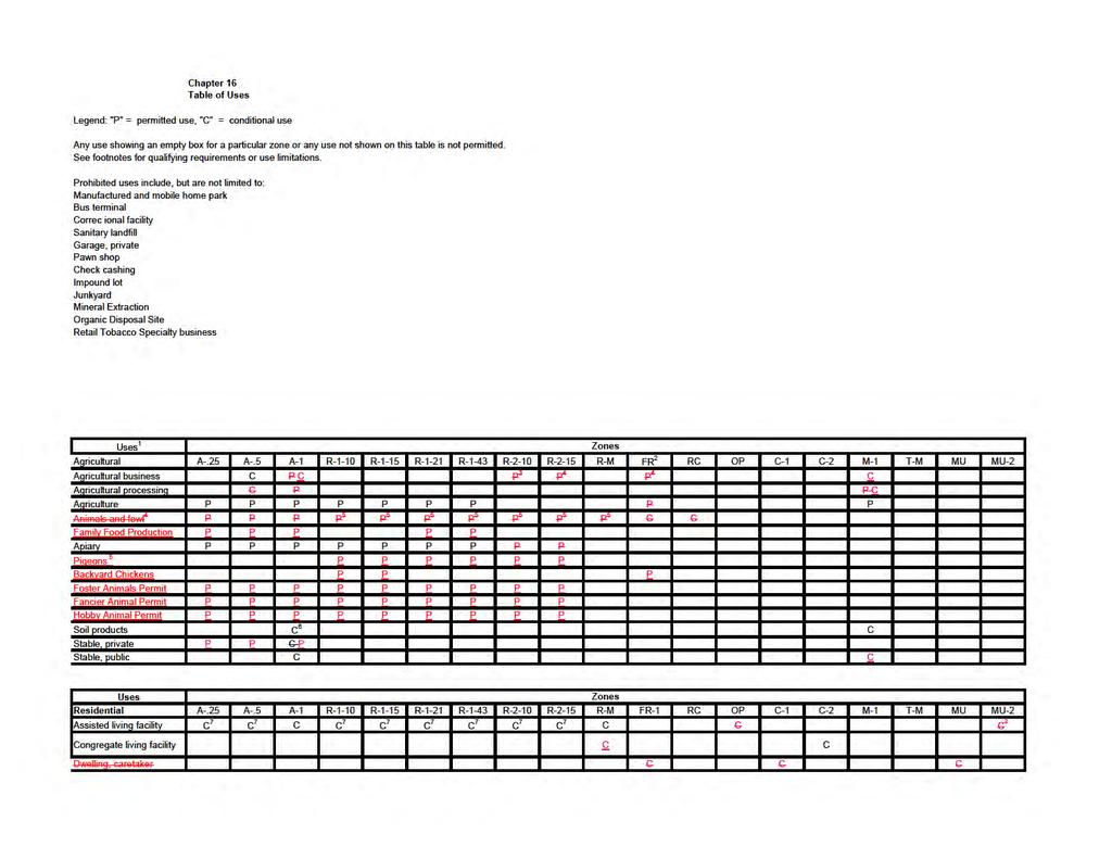
127
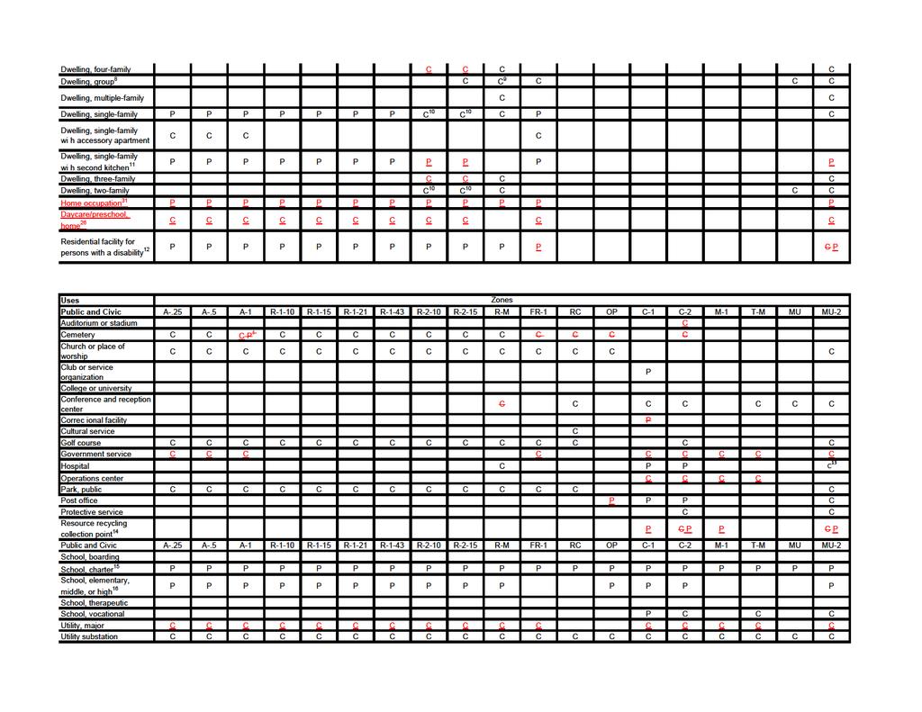
128
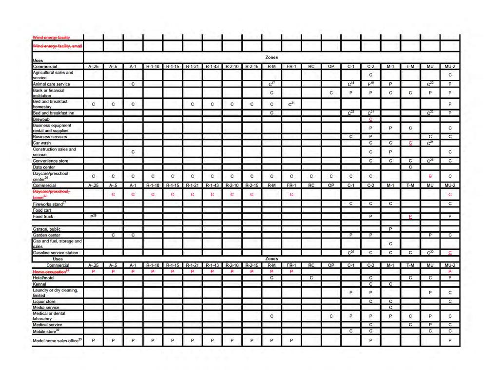
129
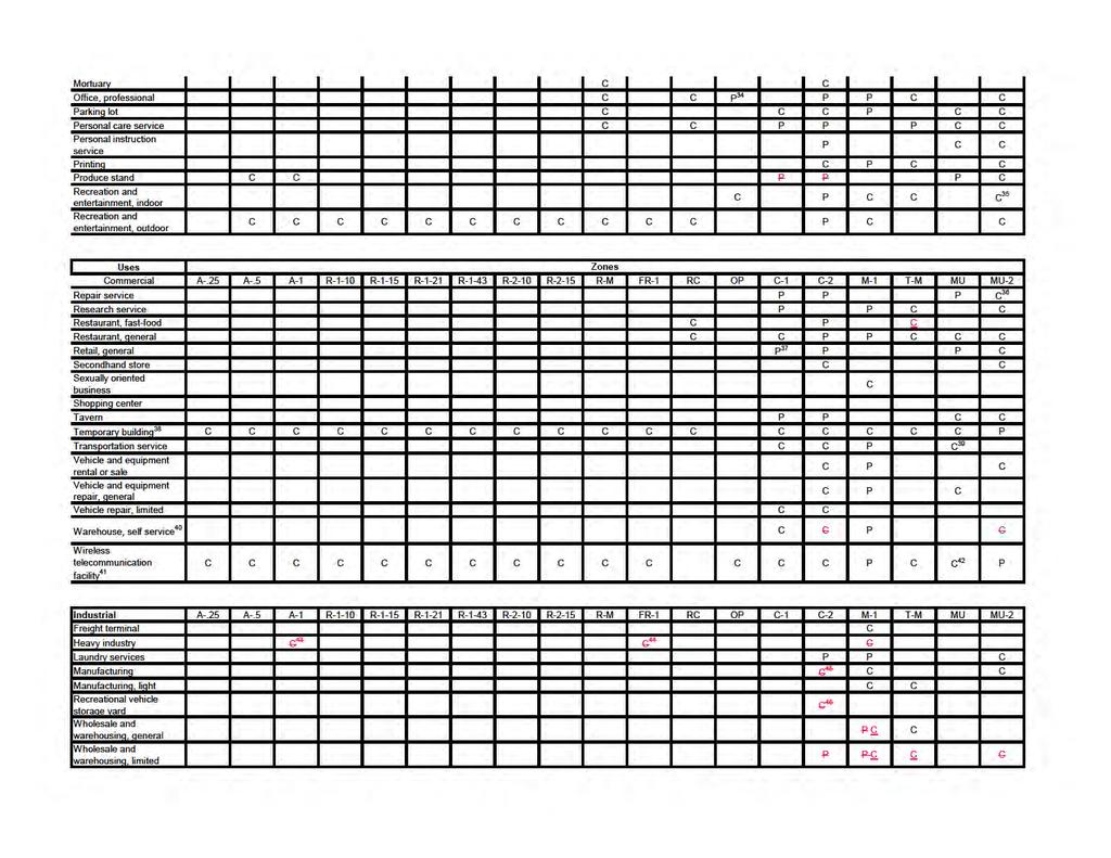
130
ARTICLE 15. RULES, REGULATIONS AND DEFINITIONS
 ARTICLE 15. RULES, REGULATIONS AND DEFINITIONS Section 1. Interpretation and Construction: The following rules and regulations regarding interpretation and construction of the Ulysses-Grant County, Kansas,
SECTION 822 "R-1-A" AND "R-1-AH" - SINGLE FAMILY RESIDENTIAL DISTRICTS
 SECTION 822 "R-1-A" AND "R-1-AH" - SINGLE FAMILY RESIDENTIAL DISTRICTS The "R-1-A" and "R-1-AH" Districts are intended to provide for the development of single family residential homes at urban standards
Town of Siler City - Unified Development Ordinance ARTICLE XII - Density and Dimensional Regulations
 ARTICLE XII - Density and Dimensional Regulations 167 Minimum Lot Size Subject to the provisions of 173 (Cluster Subdivisions) and all lots in the following zones shall have at least the amount of square
UPPER MOUNT BETHEL TOWNSHIP NORTHAMPTON COUNTY, PENNSYLVANIA
 UPPER MOUNT BETHEL TOWNSHIP NORTHAMPTON COUNTY, PENNSYLVANIA JOINDER DEED / LOT CONSOLIDATION TOWNSHIP REVIEW PROCESS When accepting proposed Joinder Deeds / Lot Consolidations, review the Joinder Deed
ARTICLE VI. SPECIAL EXCEPTION REGULATIONS
 ARTICLE VI. SPECIAL EXCEPTION REGULATIONS SECTION 601. GENERAL DESCRIPTION Special exceptions are deemed to be permitted uses in their respective districts, subject to the satisfaction of the requirements
May 12, Chapter RH HILLSIDE RESIDENTIAL ZONES REGULATIONS Sections:
 May 12, 2017 Chapter 17.13 RH HILLSIDE RESIDENTIAL ZONES REGULATIONS Sections: 17.13.010 Title, intent, and description. 17.13.020 Required design review process. 17.13.030 Permitted and conditionally
The following regulations shall apply in the R-E District:
 "R-E" RESIDENTIAL ESTATE DISTRICT (8/06) The following regulations shall apply in the R-E District: 1. Uses Permitted: The following uses are permitted. A Zoning Certificate may be required as provided
17.13 RH HILLSIDE RESIDENTIAL ZONES REGULATIONS SECTIONS:
 Effective April 14, 2011 Chapter 17.13 RH HILLSIDE RESIDENTIAL ZONES REGULATIONS SECTIONS: 17.13.010 Title, Intent, and Description 17.13.020 Required Design Review Process 17.13.030 Permitted and Conditionally
AN ORDINANCE OF THE CITY OF MINNEAPOLIS. By Palmisano
 AN ORDINANCE OF THE CITY OF MINNEAPOLIS By Palmisano Amending Title 20, Chapter 520 of the Minneapolis Code of Ordinances relating to Zoning Code: Introductory Provisions. The City Council of the City
ARTICLE ZONING DISTRICTS AND OFFICIAL MAP SEC SUPPLEMENTAL AREA, YARD AND HEIGHT RESTRICTIONS.
 SEC. 27-310. SUPPLEMENTAL AREA, YARD AND HEIGHT RESTRICTIONS. The following requirements provide exceptions or qualify and supplement the specific district regulations set forth in this part. Planned developments
City of Lynden Title 19 ZONING
 City of Lynden Title 19 ZONING Chapters Page Number 19.03 Comprehensive Plan 2 19.05 General Provisions 3 19.09 Maps and District Boundaries 4 19.11 Districts Established 5 19.13 Agricultural Zone 6 19.15
CHAPTER 2 RELATIONSHIP WITH OTHER LAWS.
 CHAPTER 2 General Provisions 12-2-1 Minimum Requirements 12-2-2 Relationship with Other Laws 12-2-3 Effect on Existing Agreements 12-2-4 Scope of Regulations 12-2-5 Building Permit 12-2-6 Nonconforming
CHAPTER 24 F FLOOD ZONE OVERLAY DISTRICT
 CHAPTER 24 OVERLAY DISTRICT SECTION 24.01 PURPOSE It is the intent of this district to apply special regulation to the use of land in those areas subject to periodic inundation. Such regulation is deemed
PROPOSED AMENDMENTS TO THE DERBY ZONING REGULATIONS AUGUST 12, 2008
 ARTICLE II Definitions and word usage 195-7. Definitions and word usage. Modify the following: HOUSING FOR THE ELDERLY OLDER PERSONS Housing in accordance with and as defined in the United States Fair
FREQUENTLY USED PLANNING & ZONING TERMS
 City Of Mustang FREQUENTLY USED PLANNING & ZONING TERMS Abut: Having property lines, street lines, or zoning district lines in common. Accessory Structure: A structure of secondary importance or function
COMMERCIAL SITE DEVELOPMENT GUIDE FOR UNINCORPORATED ST. CHARLES COUNTY
 COMMERCIAL SITE DEVELOPMENT GUIDE FOR UNINCORPORATED ST. CHARLES COUNTY GENERAL INFORMATION: This brochure is to be used as a guide and is not intended to amend or supersede the corresponding County ordinances
City of Dade City, Florida Land Development Regulations ARTICLE 5: DENSITY, INTENSITY & DIMENSIONAL STANDARDS
 City of Dade City, Florida Land Development Regulations ARTICLE 5: DENSITY, INTENSITY & DIMENSIONAL STANDARDS ADOPTED AUGUST 12, 2014 ARTICLE 5: DENSITY, INTENSITY & DIMENSIONAL STANDARDS SECTION 5.1 DIMENSIONAL
DEVELOPMENT STANDARDS FOR RESIDENTIAL PROJECTS RESIDENTIAL BUILDING TYPES: APPROPRIATE ZONES AND DENSITIES 2-1
 2 DEVELOPMENT STANDARDS FOR RESIDENTIAL PROJECTS RESIDENTIAL BUILDING TYPES: APPROPRIATE ZONES AND DENSITIES 2-1 This Chapter presents the development standards for residential projects. Section 2.1 discusses
4.2 RESIDENTIAL ZONING DISTRICTS
 4.2 RESIDENTIAL ZONING DISTRICTS A. Purpose: To define regulations and standards for each residential zoning district in the City. The following sections identify uses, regulations, and performance standards
Chapter Residential Mixed Density Zone
 Chapter 19.16 Residential Mixed Density Zone 19.16.010 Purpose and Intent 19.16.020 Permitted Uses 19.16.030 Accessory Permitted Uses 19.16.040 Secondary Permitted Uses 19.16.050 Conditional Uses 19.16.060
ARTICLE 3 DEFINITIONS
 Sections: 3-1 Rules of Construction 3-2 Definitions ARTICLE 3 DEFINITIONS SECTION 3-1 RULES OF CONSTRUCTION 3-101. a. The language set forth in these regulations shall be interpreted in accordance with
CHAPTER 2 GENERAL PROVISIONS
 CHAPTER 2 GENERAL PROVISIONS 200 ZONING DISTRICTS ESTABLISHED 201 SUPPLEMENTAL DISTRICTS ESTABLISHED 202 OFFICIAL ZONING MAP ESTABLISHED 203 DISTRICT BOUNDARY DESCRIPTION and INTERPRETATION 204 LIMITATION
RE: 6. GILL/GREEN COMPREHENSIVE PLAN AMENDMENT, REZONING AND PRELIMINARY PLAT
 commission memo DATE: Thursday - August 9, 2018 TO: Marion Planning & Zoning Commission FROM: David N. Hockett, AICP Principal Planner RE: 6. GILL/GREEN COMPREHENSIVE PLAN AMENDMENT, REZONING AND PRELIMINARY
-MENDOCINO COUNTY PLANNING AND BUILDING SERVICES- DIVISION OF LAND REGULATIONS TITLE 17
 ARTICLE VI -- GENERAL REGULATIONS AND PROVISIONS Sec. 17-50. Sec. 17-51 General Plan. Sec. 17-52 Lot and Block Design and Configuration. Sec. 17-53 Lot Access. Sec. 17-54 Private Roads. Sec. 17-55 Water
SECTION 820 "R-R" - RURAL RESIDENTIAL DISTRICT
 SECTION 820 "R-R" - RURAL RESIDENTIAL DISTRICT The "R-R" District is intended to create or preserve rural or very large lot residential homesites where a limited range of agricultural activities may be
SECTION 821 "R-A" - SINGLE FAMILY RESIDENTIAL-AGRICULTURAL DISTRICT
 SECTION 821 "R-A" - SINGLE FAMILY RESIDENTIAL-AGRICULTURAL DISTRICT The "R-A" District is intended to provide for the development of single family residential estate homes in a semi-rural environment on
Town of Brookeville Zoning Ordinance
 Town of Brookeville Zoning Ordinance Article I. In General Section 10-101. Purpose: The Town of Brookeville has been included on the National Register of Historic Places since 1979 and designated as an
(Chapter Flood Damage Prevention)
") Chapter 13.10 Flood Damage Prevention Section: 13.10.010 Purpose and Policy 13.10.020 Definitions 13.10.030 Applicability and Areas of Special Flood Hazard 13.10.040 Administration 13.10.050 Provisions
Chapter 13.10 Flood Damage Prevention Section: 13.10.010 Purpose and Policy 13.10.020 Definitions 13.10.030 Applicability and Areas of Special Flood Hazard 13.10.040 Administration 13.10.050 Provisions
DEFINITIONS. 202 General Construction of Language The following general rules of construction apply to the text of the Zoning Regulations.
 2 ARTICLE TWO DEFINITIONS 201 Purpose Article Two shall be known as the Definitions. The purpose of these provisions is to promote consistency and precision in the interpretation of the Zoning Regulations.
ARTICLE 5.0 SCHEDULE OF REGULATIONS
 ARTICLE 5.0 SCHEDULE OF REGULATIONS Section 5.101 Table of Dimensional Standards by District. Dimensional Standards AG AG with sewer Districts Rural Residential Business Other SF SF with sewer R-1 R-1
5.0 Specific Use Regulations
 5.0 Specific Use Regulations SPECIFIC 5.1 Application 5.1.1 In addition to the Regulations for the specific zones where the specific uses are allowed, the Specific Use Regulation shall apply to all development
CHAPTER 154: SIGNS. Section
 CHAPTER 154: SIGNS Section 154.01 Permit required 154.02 Where prohibited 154.03 Street decorations 154.04 Approval by state 154.05 Purpose 154.06 Definitions 154.07 General sign and street graphics regulations
DOUGLAS COUNTY ZONING RESOLUTION Section 4 LRR - Large Rural Residential District 3/10/99. -Section Contents-
 SECTION 4 LRR LARGE RURAL RESIDENTIAL DISTRICT -Section Contents- 401 Intent... 4-2 402 Principal Uses... 4-2 403 Accessory Uses... 4-3 404 Uses Permitted by Special Review... 4-4 405 Land Dedication...
New Zoning Ordinance Program
 City of Goleta New Zoning Ordinance Program Module 3: Regulations Applying to Multiple Districts General Site Regulations Landscaping Parking and Loading June 09, 2014 New Zoning Ordinance Program By:
SECTION 5: ACCESSORY USES
 SECTION 5: ACCESSORY USES A. In Any District Subject to the restrictions of the Zoning Resolution, a use, equipment or item customarily incidental to an existing permitted use on a lot shall also be permitted
ORDINANCE NO. Be it ordained by the City Council of the City of Abilene, Texas:
 ORDINANCE NO. An ordinance repealing Chapter 23, Subpart B of the Code of the City of Abilene, Texas, entitled Mobile Homes and Vacation Travel Trailers; stating the authority; setting forth the scope
ARTICLE 23 CONDOMINIUM STANDARDS
 ARTICLE 23 CONDOMINIUM STANDARDS Section 23.01 Intent. The intent of this Article is to provide regulatory standards for condominiums and site condominiums similar to those required for projects developed
Article 18. Sign Regulations
 Article 18. Sign Regulations Section 18.01 Purpose and Intent Section 18.02 Use Regulations Section 18.03 Classification of Signs Section 18.04 Structural Types Section 18.05 General Standards Section
ARTICLE III: LAND USE DISTRICTS 302 R 5 DISTRICT
 ARTICLE III: LAND USE DISTRICTS III 7 302 R 5 DISTRICT (RESIDENTIAL 5 UNITS PER ACRE) 302 1 Intent and Purpose The R 5 District is intended to implement the policies of the Comprehensive Plan for areas
Section 7.22: Multifamily Assisted Housing in AA-30 Residential Zone (MAHZ) [Note: an additional line will be added to the Table in Article 3, 3.1.
 [Note: an additional line will be added to the Table in Article 3, 3.1.") Section 7.22: Multifamily Assisted Housing in AA-30 Residential Zone (MAHZ) [Note: an additional line will be added to the Table in Article 3, 3.1.1A] 7.22.1 Purpose The purpose of this Special Regulation
Section 7.22: Multifamily Assisted Housing in AA-30 Residential Zone (MAHZ) [Note: an additional line will be added to the Table in Article 3, 3.1.1A] 7.22.1 Purpose The purpose of this Special Regulation
Article. Table of Contents City of Birmingham Zoning Ordinance. 2006, Bradley E. Johnson, AICP
 00 Table of Contents City of Birmingham Zoning Ordinance 2006, Bradley E. Johnson, AICP Table of Contents One: Zoning Ordinance Foundation Page # 1.01 Title... 1-2 1.02 Defined Words... 1-2 1.03 Authority...
SECTION 7000 LAND DEVELOPMENT REQUIREMENTS
 SECTION 7000 LAND DEVELOPMENT REQUIREMENTS 7000 LAND DEVELOPMENT REQUIREMENTS... 1 7001 LEGISLATIVE AUTHORITY... 1 7001.1 LAND DEVELOPMENT... 1 7001.1.1 Title 40, Idaho Code... 1 7001.1.2 Idaho Code 40-1415
Article 7: Residential Land Use and Development Requirements
 Article 7: Residential Land Use and Section 701: Statement of Intent (A) (B) (C) The intent of Article 7 is to develop certain land use and development requirements for the residential uses within Cumru
APPENDIX A-5 Definitions
 APPENDIX A-5 Definitions Purpose The purpose of this section is to promote consistency and precision in the application and interpretation of development and zoning terms and definitions. The meaning and
Town of Alexandria. Floodplain Management Ordinance
 1 of 7 8/8/2009 4:56 PM Town of Alexandria Floodplain Management Ordinance SECTION 1 PURPOSE Certain areas of the Town of Alexandria, New Hampshire are subject to periodic flooding, causing serious damages
Residential Project Convenience Facilities
 Standards for Specific Land Uses 35.42.220 E. Findings. The review authority shall approve a Land Use Permit in compliance with Subsection 35.82.110.E (Findings required for approval) or a Conditional
ARTICLE III ZONING DISTRICTS AND GENERAL REGULATIONS
 ARTICLE III ZONING DISTRICTS AND GENERAL REGULATIONS 3.1 Districts. The City of Wheaton, Illinois, is hereby divided into the following zoning districts. The following are general descriptions, but not
Condominium Unit Requirements.
 ARTICLE 19 CONDOMINIUM REGULATIONS Section 19.01 Purpose. The purpose of this Article is to regulate projects that divide real property under a contractual arrangement known as a condominium. New and conversion
RURAL SETTLEMENT ZONE - RULES
 Chapter 38 RURAL SETTLEMENT ZONE - RULES INTRODUCTION This Chapter contains rules managing land uses in the. The boundaries of this zone are shown on the planning maps. There is limited opportunity for
 Page 1 of 8 Laguna Beach Municipal Code Up Previous Next Main Collapse Search Print No Frames Title 25 ZONING Chapter 25.10 R-1 RESIDENTIAL LOW DENSITY ZONE 25.10.002 Intent and purpose. This zone is intended
ARTICLE 24 SITE PLAN REVIEW
 ARTICLE 24 SITE PLAN REVIEW 24.1 PURPOSE: The intent of these Ordinance provisions is to provide for consultation and cooperation between the land developer and the Township Planning Commission in order
610 LAND DIVISIONS AND PROPERTY LINE ADJUSTMENTS OUTSIDE A UGB
 ARTICLE VI: LAND DIVISIONS AND PROPERTY LINE ADJUSTMENTS VI-21 610 LAND DIVISIONS AND PROPERTY LINE ADJUSTMENTS OUTSIDE A UGB 610-1 Property Line Adjustments (Property Line Relocation) A property line
the conditions contained in their respective Orders until January 1, 2025, at the discretion of the Director of Planning, Property and Development.
 Part 4: Use Regulations Temporary Uses and Structures Purpose the conditions contained in their respective Orders until January 1, 2025, at the discretion of the Director of Planning, Property and Development.
15.02 PERMITTED USES: The following uses and no other shall be deemed Residential, R-1, uses and permitted in all R-1 districts:
 Amended October 3, 1994, Effective November 3, 1994 Revised effective November 16, 1995, Revised effective 12/1/04, Revised effective 7/06/06, Revised effective 7/18/07, Revised effective 9/03/09, Revised
ORDINANCE NO The Town Council of the Town of Yucca Valley does ordain as follows:
 ORDINANCE NO. 141 AN ORDINANCE OF THE TOWN COUNCIL OF THE TOWN OF YUCCA VALLEY, CALIFORNIA, AMENDING TITLE 8, DIVISION 12, CHAPTER 1 RELATING TO DEFINITIONS AND TITLE 8, DIVISION 8, CHAPTER 3, RELATING
Draft Model Access Management Overlay Ordinance
 Draft Model Access Management Overlay Ordinance This model was developed using the City of Hutchinson and the Trunk Highway 7 corridor. The basic provisions of this model may be adopted by any jurisdiction
 Page 1 of 9 Escondido Municipal Code Up Previous Next Main Collapse Search Print No Frames Chapter 33 ZONING ARTICLE 8. RESIDENTIAL ESTATES (R-E) ZONE Sec. 33-120. Purpose. The purpose of the residential
H 7741 SUBSTITUTE A ======== LC005052/SUB A/2 ======== S T A T E O F R H O D E I S L A N D
 01 -- H 1 SUBSTITUTE A LC000/SUB A/ S T A T E O F R H O D E I S L A N D IN GENERAL ASSEMBLY JANUARY SESSION, A.D. 01 A N A C T RELATING TO TOWNS AND CITIES -- ZONING ORDINANCES Introduced By: Representatives
Single-Dwelling Zones 110
 Title 33, Planning and Zoning Chapter 33.110 1/1/15 Single-Dwelling Zones 33.110 Single-Dwelling Zones 110 Sections: General 33.110.010 Purpose 33.110.020 List of the Single-Dwelling Zones 33.110.030 Other
ARTICLE 15 - PLANNED UNIT DEVELOPMENT
 Section 15.1 - Intent. ARTICLE 15 - PLANNED UNIT DEVELOPMENT A PUD, or Planned Unit Development, is not a District per se, but rather a set of standards that may be applied to a development type. The Planned
FINAL DRAFT 12/1/16, Rev. to 7/18/17
 FINAL DRAFT 12/1/16, Rev. to 7/18/17 (As Adopted 8/8/17 Effective 9/1/17) SHELTON PLANNING AND ZONING COMMISSION Proposed Amendments to Zoning Regulations I. Amend Section 23 PERMITTED USES by inserting
Packet Contents: Page #
 CLEAR CREEK COUNTY PLANNING DEPARTMENT REQUIREMENTS FOR COMMERCIAL AND MULTI-FAMILY DEVELOPMENTS Prior to submitting a building permit application, the Planning staff will review the site plan and construction
Salem Township Zoning Ordinance Page 50-1 ARTICLE 50.0: PUD PLANNED UNIT DEVELOPMENT
 Salem Township Zoning Ordinance Page 50-1 ARTICLE 50.0 PLANNED UNIT DEVELOPMENT Section 50.01 Purpose The provisions of this Article provide enabling authority and standards for the submission, review,
DORSET ZONING BYLAW-APPROVED MARCH 5, 2002 BY VOTERS OF THE TOWN OF DORSET, VERMONT
 APPENDIX A: DEFINITIONS For the purpose of this Bylaw, certain terms or words shall be defined as below. All other words shall retain their dictionary meaning as found in any readily available dictionary,
Chapter 17-2 Residential Districts
 Chapter 17-2 Residential Districts 17-2-0100 District Descriptions...2-1 17-2-0200 Allowed Uses...2-2 17-2-0300 Bulk and Density Standards...2-5 17-2-0400 Character Standards...2-18 17-2-0500 Townhouse
5.2 GENERAL MEASUREMENT REQUIREMENTS
 Sec. 5.2.1 / Density 5.2 GENERAL MEASUREMENT REQUIREMENTS 5.2.1 Density Density shall be measured by taking the quotient of the total number of dwelling units on a site proposed for development divided
Spring City Municipal Corporation
 Spring City Municipal Corporation (435) 462-2244 FAX: (435) 462-2654 www.springcityutah.org 150 East Center Street P.O. Box 189 Spring City, Utah 84662 For Your Information All appointments with Public
FENCE PERMIT APPLICATION
 Village of Glen Ellyn Planning & Development Department 535 Duane Street Glen Ellyn, IL 60137 Phone: 630-547-5250; Fax: 630-547-5370 www.glenellyn.org FENCE PERMIT APPLICATION Permit Number Date Issued
Planning Commission recommends APPROVAL of the amendment to Article 4, Article 7, and Article 14 as presented by Staff on 6/19/17.
 DATE: June 20, 2017 TO: FROM: SUBJECT: Mayor and City Council Planning Director Zoning Ordinance Amendment Article 4, Article 7, and Article 14 related to accessory uses, fences, walls, and administrative
FENCE BUILDING PERMIT APPLICATION
 Village of Glen Ellyn Planning & Development Department 535 Duane Street Glen Ellyn, IL 60137 Phone: 630-547-5250; Fax: 630-547-5370 www.glenellyn.org FENCE BUILDING PERMIT APPLICATION Permit Number Date
Chapter CC COMMUNITY COMMERCIAL ZONES REGULATIONS
 Effective April 14, 2011 Chapter 17.35 CC COMMUNITY COMMERCIAL ZONES REGULATIONS SECTIONS: 17.35.010 Title, Intent, and Description 17.35.020 Required Design Review Process 17.35.030 Permitted and Conditionally
City of Valdosta Land Development Regulations
 Chapter 214 Standards Applying to All Districts Section 214-1 Dimensional Standards of Zoning Districts Dimensional standards for zoning districts are summarized in Tables 1, 2 and 3. See Chapter 6 for
WASCO COUNTY PRELIMINARY SUBDIVISION APPLICATION
 WASCO COUNTY PRELIMINARY SUBDIVISION APPLICATION DETAILED SPECIFIC WRITTEN REQUEST File Number: SDV- Number of Proposed Lots & their Dimensions: PRELIMINARY SUBDIVISION PLAN REQUIREMENTS The approval of
PRELIMINARY SUBDIVISION PLAN APPLICATION INSTRUCTIONS
 City of Chesapeake Department of Planning Post Office Box 15225 Chesapeake, Virginia 23328-5225 (757) 382-6176 FAX (757) 382-6406 PRELIMINARY SUBDIVISION PLAN APPLICATION INSTRUCTIONS PURPOSE A preliminary
CHAPTER 13 SIGNS 13-1
 SECTION 13.1 PURPOSE AND INTENT The purpose of this Chapter is to promote traffic safety, public safety, and the conservation of property values through the application of reasonable controls over the
CHAPTER 14 PLANNED UNIT DEVELOPMENTS
 9-14-1 9-14-1 CHAPTER 14 PLANNED UNIT DEVELOPMENTS SECTION: 9-14-1: Purpose 9-14-2: Governing Provisions 9-14-3: Minimum Area 9-14-4: Uses Permitted 9-14-5: Common Open Space 9-14-6: Utility Requirements
Planned Residential Development Zone
 SECTION 55 Planned Residential Development Zone 55.0 [Reserved] 55.1 General The Planned Residential Development (PRD) Zone is a class of zone in addition to and overlapping a portion or portions of the
Article 9 Signs and Billboards
 Article 9 Signs and Billboards Section 9.01 Intent and Purpose The intent of this article is to regulate the type, number, physical dimensions, erection and placement of signs in Arbela Township. The purpose
Preliminary Subdivision Application (Minor) (Three (3) lots or less)
 (Three (3) lots or less)") Gunnison City Offices www.gunnisoncity.org 38 West Center Gunnison, Utah 84634 (435) 528 7969 Date of Application: Preliminary Subdivision Application (Minor) (Three (3) lots or less) APPLICANT INFORMATION
Gunnison City Offices www.gunnisoncity.org 38 West Center Gunnison, Utah 84634 (435) 528 7969 Date of Application: Preliminary Subdivision Application (Minor) (Three (3) lots or less) APPLICANT INFORMATION
CITY OF EAU CLAIRE, WISCONSIN. SPECIAL ASSESSMENT POLICY (Dated: November 8, 2016)
") CITY OF EAU CLAIRE, WISCONSIN SPECIAL ASSESSMENT POLICY (Dated: November 8, 2016) (Adopted by reference by Ordinance No. 7207 adopted November 8, 2016) PURPOSE The purpose of this Policy is to assure fair
CITY OF EAU CLAIRE, WISCONSIN SPECIAL ASSESSMENT POLICY (Dated: November 8, 2016) (Adopted by reference by Ordinance No. 7207 adopted November 8, 2016) PURPOSE The purpose of this Policy is to assure fair
ZONING ORDINANCE: OPEN SPACE COMMUNITY. Hamburg Township, MI
 ZONING ORDINANCE: OPEN SPACE COMMUNITY Hamburg Township, MI ARTICLE 14.00 OPEN SPACE COMMUNITY (Adopted 1/16/92) Section 14.1. Intent It is the intent of this Article to offer an alternative to traditional
Appendix A. Definitions
 Definitions 1. Terms Defined. Words contained in this are those having a special meaning relative to the purposes of this Ordinance. Words not listed in this section shall be defined by reference to: (1)
WHEREAS, on October 6, 2015, the Planning Commission held a duly noticed public hearing and recommended the proposed Ordinance Amendments; and
 ORDINANCE NO. ORDINANCE OF THE CITY COUNCIL OF THE CITY OF REDWOOD CITY AMENDING ARTICLE 2, ARTICLE 5, ARTICLE 30, ARTICLE 36, ARTICLE 37, AND ARTICLE 45 OF THE REDWOOD CITY ZONING ORDINANCE AND AMENDING
Article 30: Residence Zones
 ARTICLE 30, Use Regulations Controlling Residence Zones 118-300. Island Conservation Zone. [Added effective 1-22-1974] A. Declaration of necessity and purpose. Article 30: Residence Zones (1) It is declared
Special Use Permit - Planned Unit Development Checklist. Property Address:
 Special Use Permit - Planned Unit Development Checklist Special Use Permit Number. Parcel Code/s #28-11- - - Property Address: Applicant: ARTICLE VIII Ordinance Reference - Section 8.1.2 Permit Procedures:
ARTICLE 11. NAMEPLATES AND SIGNS Signs in all districts.
 //Culpeper County, Virginia/CODE OF ORDINANCES COUNTY OF CULPEPER, VIRGINIA Codified through Ordinance of November 7, 2007. (Supplement No. 3)/APPENDIX A ZONING ORDINANCE*/ARTICLE 11. NAMEPLATES AND SIGNS
ARTICLE 5 GENERAL REQUIREMENTS
 5.1 SUITABILITY OF THE LAND ARTICLE 5 GENERAL REQUIREMENTS 5.1.1 Land subject to flooding, improper drainage or erosion, and land deemed to be unsuitable for development due to steep slope, unsuitable
Preliminary Subdivision Application (Major) (Four (4) lots or more)
 (Four (4) lots or more)") Gunnison City Offices www.gunnisoncity.org 38 West Center Gunnison, Utah 84634 (435) 528 7969 Date of Application: Preliminary Subdivision Application (Major) (Four (4) lots or more) APPLICANT INFORMATION
Gunnison City Offices www.gunnisoncity.org 38 West Center Gunnison, Utah 84634 (435) 528 7969 Date of Application: Preliminary Subdivision Application (Major) (Four (4) lots or more) APPLICANT INFORMATION
CHAPTER 5. PLANNED UNIT DEVELOPMENT REGULATIONS
 Section 5.1. Purpose CHAPTER 5. PLANNED UNIT DEVELOPMENT REGULATIONS 5.1. PURPOSE The purpose for Planned Unit Developments (PUDs) is established in Section 4.5 Zoning District Purpose Statements. 5.2.
ARTICLE 13 CONDOMINIUM REGULATIONS
 ARTICLE 13 CONDOMINIUM REGULATIONS Section 13.01 Purpose. The purpose of this Article is to regulate projects that divide real property under a contractual arrangement known as a condominium. New and conversion
Bulk Requirements (For other supplementary location and bulk regulations, see Article VII.)
") 4.13 TOWNSITE OVERLAY DISTRICT (TO) 4.13.1 Purpose The purpose of the Townsite Overlay District is to promote the health, safety and welfare of current and future residents of the City of Hailey; to modify
4.13 TOWNSITE OVERLAY DISTRICT (TO) 4.13.1 Purpose The purpose of the Townsite Overlay District is to promote the health, safety and welfare of current and future residents of the City of Hailey; to modify
ARTICLE VII. NONCONFORMITIES. Section 700. Purpose.
 ARTICLE VII. NONCONFORMITIES. Section 700. Purpose. The purpose of this chapter is to regulate and limit the development and continued existence of legal uses, structures, lots, and signs established either
Washington County, Minnesota Ordinances
 Washington County, Minnesota Ordinances Ordinance No. 153 Text Amendment to the Washington County Development Code - Chapter One, Section 2 and Chapter Two, Part 1, Part 2, Part 3, of the Development Code
CONDOMINIUM REGULATIONS
 ARTICLE 37 CONDOMINIUM REGULATIONS SECTION 37.01. Purpose The purpose of this Article is to regulate projects that divide real property under a contractual arrangement known as a condominium. New and conversion
CHAPTER 1268 R-1, R-2 AND R-3 RESIDENTIAL DISTRICTS
 CHAPTER 1268 R-1, R-2 AND R-3 RESIDENTIAL DISTRICTS 1268.01 PURPOSE. Residential districts and their regulations are established in order to achieve, among others, the following purposes: (a) To regulate
CONDITIONAL USE PERMIT APPLICATION FOR AN EXCAVATION/BORROW PIT INSTRUCTIONS
 City of Chesapeake Department of Planning Post Office Box 15225 Chesapeake, Virginia 23328-5225 (757) 382-6176 FAX (757) 382-6406 CONDITIONAL USE PERMIT APPLICATION FOR AN EXCAVATION/BORROW PIT INSTRUCTIONS
Sign, Canopy: A sign attached to the underside of a canopy.
 SECTION 15 SIGNS 15.1 Purpose: The requirements established herein are designed to regulate sign structures in order to insure light, air, and open space; to reduce hazards at intersections; to prevent
ARTICLE C. ZONING TEXT, DISTRICT CLASSIFICATIONS AND BOUNDARIES
 ARTICLE C. ZONING TEXT, DISTRICT CLASSIFICATIONS AND BOUNDARIES Sec. 10-2054. ZONING TEXT, DISTRICT CLASSIFICATIONS AND BOUNDARIES. In order to regulate the location of structures, the height and bulk
PLANNING COMMISSION STAFF REPORT
 PLANNING COMMISSION STAFF REPORT AMENDMENTS TO CHAPTER 21A.40.050: 5 Foot Maximum Rear Setback for Accessory Structures Case # 4 April 2011 Planning and Zoning Division Department of Community and Economic
Article 1 UNIVERSITY PARK ZONING DRAFT. LEGEND See inside front cover. August 31, 2018 DRAFT 4.0 ZONING ORDINANCE CITY OF UNIVERSITY PARK
 Article 1 UNIVERSITY PARK ZONING DRAFT LEGEND See inside front cover DRAFT 4.0 August 31, 2-12018 Article 1 LEGEND Proposed deletion of existing ordinance provision (red text with red strke-through) Proposed