From: Hal Simmons, Planning Director. CAR Annexation on Maple Grove Road with M-1D Zoning
|
|
|
- Aleesha Richardson
- 5 years ago
- Views:
Transcription
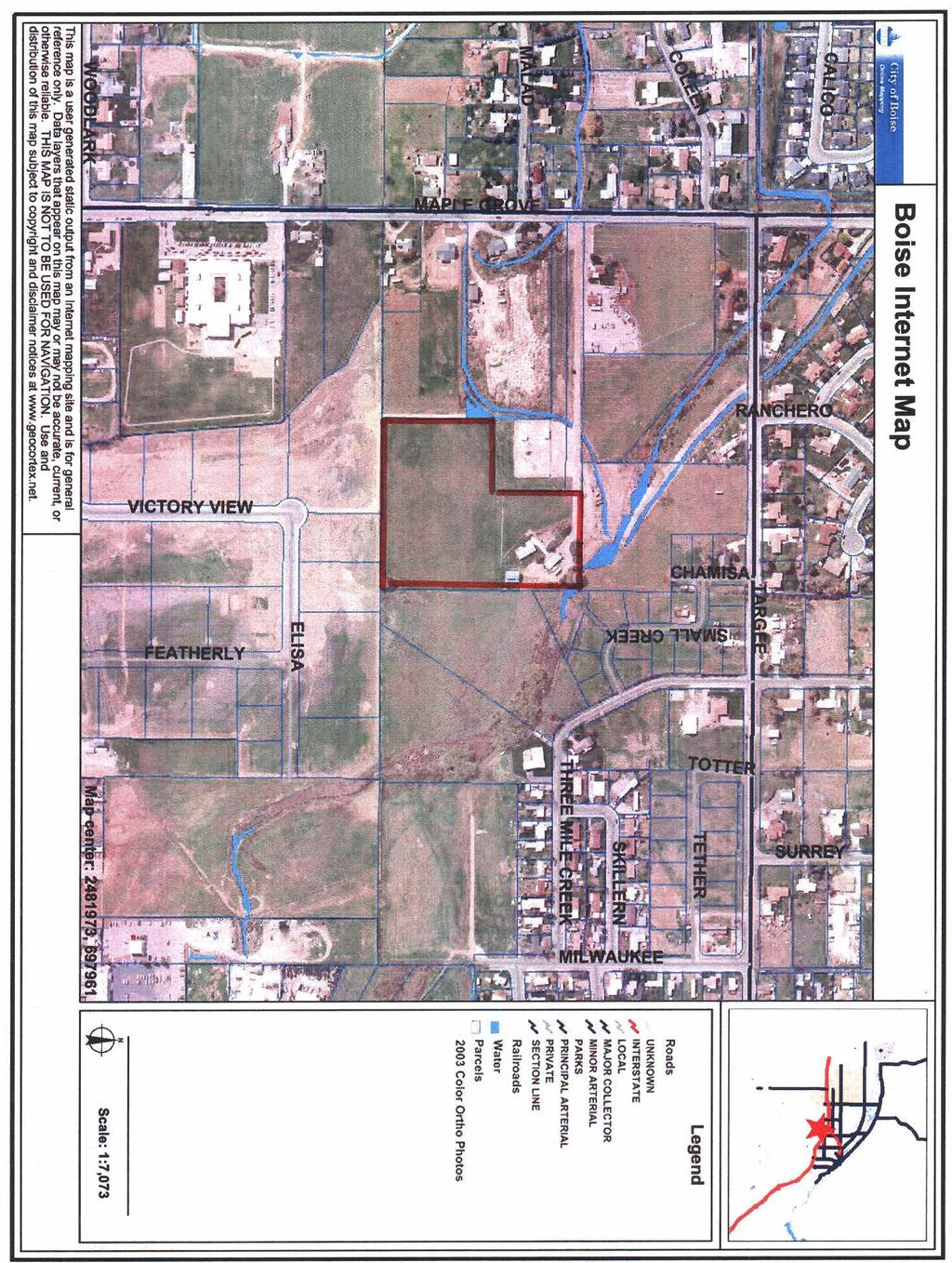
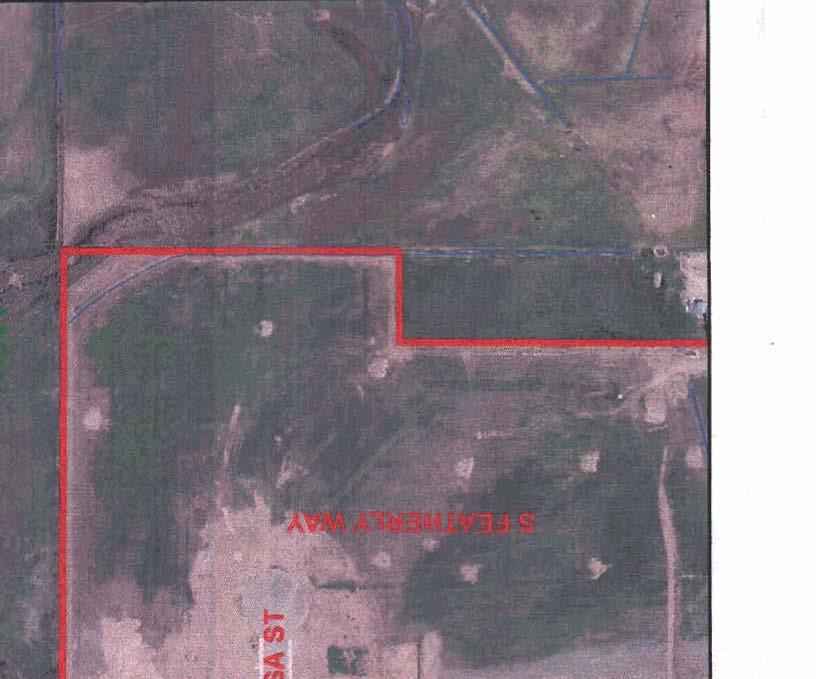
1 I I I I B O I S E 'iiiiii- Bruce D. Chanerton Boire City Hall 150 N. C~pilol Boulevard Moiling Address P 0 Box 500 Boire, ldoho Phone Planning & Development Services MEMORANDUM To: Mayor Bieter and City Council From: Hal Simmons, Planning Director Date: December 20,2006 Web mcityofboiseorgipdr Re: CAR Annexation on Maple Grove Road with M-1D Zoning Moyor Dorid H. Bieter Ci* Council President Maryonne lordon Counril ProTem Elaine Clegg Vernon L. Birlerfeldt David Eberle Alan W. Shedy Jim Tibbr The following application has been scheduled for hearing by the CounciI on January 9,2007: Tyler Pond requests approval of annexation of 8.12 acres located at 2400 S. Maple Grove Road with a zoning designation of M-1D (Limited Iindustrial with Design Review Overlay). The Boise City Planning and Zoning Commission rewrnmended approval of the application at its November 13, 2006 meeting. Table of Contents Page 2 Page 3 Page 4 Page 5 Page 6 Page 7 Summary Vicinity Map 2003 Aerial Photograph Applicant's Lettet of Explanation Minutes ofnovember 13,2006, P&Z Hearing Staff Report
 is located adjacent to Boise City limits at the south and west property lines.")
2 Summary The applicant requests annexation of *8.12 acres at 2400 S. Maple Grove Road with a zoning designation of M-ID (Limited Industrial with Design Review). The mostly vacant site (except for one single family residence) is located adjacent to Boise City limits at the south and west property lines. The site is within the Boise Area of Impact and the Boise Airport Influence Area "B-1." Currently the site is under Ada County jurisdiction and is zoned R1 (Low Density Residential). The Comprehensive Plan designates the property as Industrial. The Comprehensive Plan Land Uselzoning Consistency Matrix indicates that M-1 is an acceptable zone for this designation. The applicant has indicated that the property will be subdivided in the hture (possibly by a subsequent owner) in order to develop with light industrial uses and to provide street access. This request meets requirements of the Idaho Code and the Boise City Zoning Ordinance for annexation. Policies of the Comprehensive Plan for sustainable growth and economic development will also be met by this proposal. The site is bordered on the west by an Idaho Power substation and on the south by a currently-developing industrial subdivision. Staffsupports the requested annexation as it will facilitate the orderly expansion of city boundaries and increase economic development activity within the city. The annexation will not negatively impact neighboring properties or public services. Staff notes that this property is largely surrounded by land that was incorporated via a City-initiated annexation in 1994 that included several square miles located between Overland and Victory Roads. This parcel and several others were not included in the annexation because they are over 5 acres in size and the owners did not consent to annexation at the time. The subject site does not have hntage on a public street. The only access is a 60 foot wide, 950 foot long easement over property owned by Idaho Power. The applicant is aware that no development of any kind can be approved nor any building pennit be issued without the following: 1) compliance with zoning code and Fire Department standards for secondary access; 2) City-approved public or private streets; and 3) an approved subdivision plat. Without these, the only use that can occur after annexation is what is occurring now: one single family residence. Annexation as proposed will change the jurisdiction and zoning, but will not vest the owner with any entitlements.
3
4
5 Tyler Pond W. Fiddler Dr. Boise, ID Sep 22"*, 2006 Boise City Planning & Development Services 150 N. Capitol Blvd Boise, ID RE: Letter of Explanation for Zone Change of 2400 S. Maple Grove Rd. to MI To Whom It May Concern: I am requesting an annexation/rezone of my property because it is clearly the best use for the location. The comprehensive plan designates industrial. all of the property to the south is currently industrial, and the property at the North and West border is an Idaho Power substation (Industrial). The property touching the North East corner will be a residential use, however, the common lot of the subdivision provides a buffer between uses. There is also a creek with a lot of tall trees and natural growth to provide further separation between properties. In addition, this property is in the airport flyover zone, which is yet another reason to avoid a residential use. U'hen the neighborhood meeting was held, all that attended were in support of this application. SE? 2 5 2C25 PlANNlNG & DEVELOPMENT SERVICES
6 - 1% I Phone Boise City Planning & Development Services 150 N. Capitol Blvd a P 0 Box 500 a Boise, Idaho / Fox Planning & Zoning Commission Hearing Minutes of November 13,2006 Commission Members Present Gene FadnesdChairman, Doug Cooper, Andy Brunelle, Doug Russell, Amber Van Ocker, & Tony Blahd. Stnff Members Present Susan Riggs, Cody Riddle, Todd Tucker, Scott Spjute, Joan Johnson, Lance Evans, Pam Engelhardt & Mary Watson (Legal). CAR /TYLER POND Location: 2400 S. Maple Grove Road REQUESTS APPROVAL FOR ANNEXATION OF L8.12 ACRES WITH A ZONING DESIGNATION OF M-ID. Chairman W.: Applicant was present and did agree with the terms and conditions ofthe staff report. No public opposition. Commission waived staffreport. Commission made a motion to approve the application with staffs recommended conditions of approval, findings of hct and conclusions of law. Motion seconded. Motion carries.
7 Phone: 208/3&( N. Capitol Boulevard Fox: 208/ P 0. Box 500 TDDm 800! Boise, Idaho Webrite: w.cityofboise.org!pds Planning Division Staff Report File Number CAR06-65 Applicant Tyler Pond Property Address 2400 S. Maple Grove Road Public Hearing Date November 13,2006 Heard by Boise City Planning and Zoning Commission Planning Analyst Scott Spjute Table of Contents 1. Executive Summary 2. Facts, Standards of Review & Analysis 3. Reasons for the Decision 4. General Information 5. Boise City Comprehensive Plan 6. Boise City Zoning Ordinance Attachments VicinitytZoning Maps Annexation Application Applicant's Support Material Agency Comments
. Staffs Recommendation: Staff recommends approval of CAR06-65.")
8 CAR06-65 Boise City Planning and Zoning Commission 1 November 13,2006 2of Executive Summary Description of Applicant's Request: Tyler Pond requests approval for annexation of i8.12 acres located at 951 E. Gowen Road with a zoning designation of M-1 D (Limited Industrial with Design Review Overlay). Staffs Recommendation: Staff recommends approval of CAR Summary: The applicant requests annexation of i8.12 acres at 2400 S. Maple Grove Road with a zoning designation of M-ID (Limited Industrial with Design Review). The mostly vacant site (except for one single family residence) is located adjacent to Boise City limits at the south and west property lines. The site is within the Boise Area of Impact and the Boise Airport Influence Area "B-1." Currently the site is under Ada County jurisdiction and is zoned R1 (Low Density Residential). The Comprehensive Plan designates the property as Industrial. The Comprehensive Plan Land Use/Zoning Consistency Matrix indicates that M-1 is an acceptable zone for this designation. The applicant has indicated that the property will be subdivided in the future (possibly by a subsequent owner) in order to develop with light industrial uses and to provide street access. This request meets requirements of the Idaho Code and the Boise City Zoning Ordinance for annexation. Policies of the Comprehensive Plan for sustainable growth and economic development will also be met by this proposal. The site is bordered on the west by an Idaho Power substation and on the south by a currently-developing industrial subdivision. Staff supports the requested annexation as it will facilitate the orderly expansion of city boundaries and increase economic development activity within the city. The annexation will not negatively impact neighboring properties or public services. Staff notes that this property is largely surrounded by land that was incorporated via a Cityinitiated annexation in 1994 that included several square miles located between Overland and Victory Roads. This parcel and several others were not included in the annexation because they are over 5 acres in size and the owners did not consent to annexation at the time. The subject site does not have hntage on a public street. The only access is a 60 foot wide, 950 foot long easement over property owned by Idaho Power. The applicant is aware that no development of any kind can be approved nor any building permit be issued without the following: 1) compliance with zoning code and Fire Department standards for secondary access; 2) City-approved public or private streets; and 3) an approved subdivision plat. Without these, the only use that can occur afcer annexation is what is occurring now: one single family residence. Annexation as proposed will change the jurisdiction and zoning, but will not vest the owner with any entitlements.
9 CAR06-65 Boise City Planning and Zoning Commission I November 13,2006 3of Facts, Standards of Review, and Reason for the Decision Type Application: Annexation ApplicantJStatus: Tyler Pond I Owner Location and Site Description: The subject property is located at 2400 S. Maple Grove Road, which is located east of Maple Grove Road and south of Targee Road. The site is approximately 8.12 acres and is currently vacant except for one single family residence at the northeast comer of the site. The site is within the Boise Area of Impact. The site is within the Boise Airport Influence Area "B-1" and is within the Southwest Ada County Alliance neighborhood association. Zoning, Zoning AUowances, and Comprehensive Plan Designation: Currently the site is within Ada County and zoned R1 (Low Density Residential). The applicant requests to annex the property with a zoning designation of M-ID (Limited Industrial with Design Review Overlay). The Comprehensive Plan designates the property as Industrial. The Comprehensive Plan Land UseIZoning Consistency Matrix indicates that M-1 is an acceptable zone for this designation. History of Previous Actions: None. Standards of Review Section Public Hearing The Planning and Zoning Commission shall advertise, provide notice and conduct a public hearing in accordance with Section of this Ordinance for each application to amend this Ordinance or to reclassify a zoning district. Any recommendation of the Commission relating to change, modification and reclassification of zoning districts and land use classifications and the regulations and standards thereof shall be in writing. Their recommendation shall include findings of fact supporting the purposes and objectives of zoning and otherwise securing public health, safety and general welfare. The recommendation shall specifically fmd that such changes, modifications and reclassifications of zoning districts and land use classifications and the regulations and the standards thereof: A. Comply with and conform to the Comprehensive Plan; and B. Provide and maintain sufficient transportation and other public facilities, and does not adversely impact the delivery of services by any political subdivision providing services. C. Maintain and preserve compatibility of surrounding zoning and development,

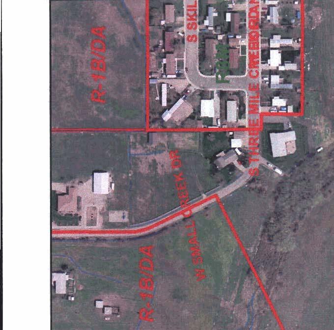
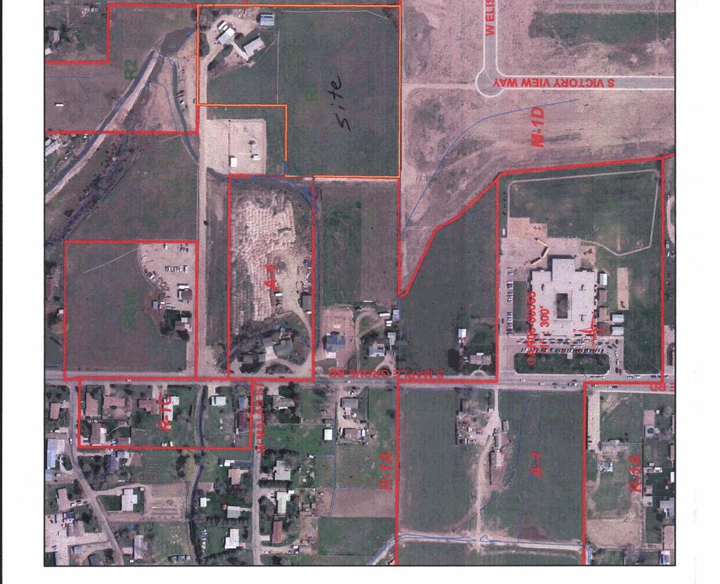
10 CAR06-65 Boise City Planning and Zoning Commission 1 November 13,2006 4of10 5 Failure of an application to meet these findings shall not prevent the request h m being forwarded to the City Council for consideration after Commission review. Notice of the Commission's recommendation shall be included in the notice of the public hearing of the City Council. Analysis Overview. The request is for annexation of *8.12 acres south of Targee Road and east of Maple Grove Road. The site is proposed for a zoning designation of M-ID (Limited Industrial with Design Review Overlay). The Boise City Comprehensive Plan designates the site as "Industrial." There are a variety of zoning designations that may be appropriate for the Industrial land use designation, including A-1, A-2, N-0, M-1, M-2, M-4, T-1, and T-2. The M-1 zoning district was established to pmvide for and encourage the grouping together of light industrial uses capable of being operated under such standards that they will be unobtrusive and will not be detrimental to surrounding commercial or residential uses. It was anticipated, then, that M-1 uses might be located near residential or commercial uses. This notion is also supported by the inclusion in the M-1 dimensional standards table of greater setback requirements when an M-1 use is located adjacent to residential uses. Section of the City Code goes on to say that areas set aside as M-1 may be classified as such in conformity with the Comprehensive Plan, and where it is found that in the public interest there is a need for industrial activities substantially free kom residential or retail commercial activities with the subsequent finding that industrial uses are the highest and best use for the land involved The annexation of the site would comply with a number of Comprehensive Plan policies by promoting proper gmwth management designed to minimize sprawl (Objective 10.1) and promote economic development policies. In line with Airport Planning Area policies, this property will be used to support industrial development and will protect the airport kom residential encroachment (Policy and ). The B-l airport overlay district encourages the development of industrial and other uses that are compatible with the operation of the airport. Residential uses are discouraged. Bordering Properties. The proposed annexation with an industrial zoning designation should prove to be compatible with existing uses and zoning in the vicinity. The Vic Park industrial subdivision borders the subject site on its southern boundary. To the west are large properties lionting on Maple Grove Road which are under developed with single family residential, but which have Office and Industrial designations on the Comprehensive Plan Land Use Map. Also to the west is an Idaho Power substation that is zoned A-1, yet which is designated by the Land Use Map for industrial development. To the north is an undeveloped 5 acre parcel zoned R-3 (Ada County). This property may develop with low density residential development in the hture, though development will be limited by policies of the airport influence area. However, the southern half of this property, adjacent to the subject site, is severely constrained by the floodway and floodplain associated
11 CAR06-65 Boise City Planning and Zoning Commission 1 November 13, of 10 5 with Five Mile Creek. Even if residential development were to occur on this property to the north, it is likely that there would be no residences within several hundred feet of the north boundary of the subject site. The eastern boundary of this site is bordered by a vacant and undeveloped 5 acre parcel zoned RSW (Ada County). The applicant and owner for the subject application has indicated that the owners of this property will also be approaching the City with the intent of obtaining industrial zoning. This would allow both properties to develop in a coordinated fashion that would facilitate street connectivity, particularly through the industrial subdivision to the south and then to Victory Road. The Boise Airport Authority responded to a request for comment by stating that it has no objection to the annexation or the proposed zoning. Policy states that protection of the airport fiom encroachment of residential uses and other incompatible forms of development shall be the highest priority for the Airport Planning Area. This policy is supported by the subject application which would remove some incompatible residential zoning and replace it with compatible industrial zoning. Current and Proposed Zoning. The current Ada County zoning of RI is designed allow for single family residential development with a density of one dwelling unit per acre. The property could be developed with up to 8 homes, but that would violate the intent of airport influence area policies which discourage non-compatible residential uses, particularly in the B, B-1 and C areas. The Industrial designation on the Land Use Map would allow for a number of zones, according to the Consistency Matrix (see excerpt fiom Matrix on page 8). However, the residential and neighborhood zones could possibly allow for uses not compatible with the airport influence area or with surrounding development, especially the industrial subdivision to the south. M-2 zoning is not appropriate because there are a number of uses allowed that are incompatible with the airport and which might not be compatible with possible hture office development to the west on Maple Grove Road. The T-1 and T-2 zones are designed to allow for technological/industrial planned developments that could not be accommodated on an 8 acre infill site such as this. Staff therefore concludes that the appropriate zone to apply to the property upon annexation is M- 1 D. Services. - Sewer lines exist on the north, west and south boundaries ofthe property. - Fire service will be provided by Station #8 on Overland Road, or Station #21, on Overland west of Maple Grove, well within the desired response time. - Water service is available fiom United Water. - Bus service is available at the intersection of Maple Gove and Overland Roads. Street Access. The subject site is accessed fiom Maple Grove Road via an easement that is owned by Idaho Power. A change to industrial zoning will allow for the submission of an industrial subdivision application that if approved would result in a code-compliant street over this easement. While it is unfortunate that a stub street to this property fiom the industrial

12 CAR06-65 Boise City Planning and Zoning Commission / November 13, of 10 5 subdivision to the south was not required, the future subdivision and development of this property and the property to the east will allow for the exploration of connection options through that subdivision. This would result in a much better street system than might be developed under the current residential zoning. The subject site does not have f?ontage on a public street. The only access is to the west to Maple Grove Road, via a 60 foot wide, 950 foot long easement over propdy owned by Idaho Power. The applicant is aware that no development of any kind can be approved nor any building permit be issued without the following: 1) compliance with zoning code and Fire Department standards for secondary access; 2) City-approved public or private streets; and 3) an approved subdivision plat. Without these, the only use that can occur afler annexation is what is occuning now: one single family residence. Annexation as proposed will change the jurisdiction and zoning, but will not vest the owner with any entitlements. This request meets requirements of the Idaho Code and the Boise Zoning Ordinance for annexation. As demonstrated in the discussion above, the annexation should not negatively impact neighboring properties and is supported by the availability of public services. Policies of the Comprehensive Plan for sustainable growth and economic development will also be met by this proposal. Staff has not received any negative comments regarding the proposal. The applicant stated that everyone who attended the pre-application neighborhood meeting expressed support. 3. Reasons for the Decision The Boise City Comprehensive Plan designates the site as "Industrial." This location is appropriate for industrial zoning due to its adjacency to an existing industrial subdivision and the potential for additional industrial development to the east. The annexation of the site conforms to many Comprehensive Plan policies by promoting proper growth management which will help to minimize sprawl (Objective 10.1). The development of this site will promote economic development in an area where municipal services are readily available. In line with Airport Planning Area policies, this area will be used for industrial development and will protect the airport from residential encroachment (Policy and ). The annexation will not adversely affect public services since a11 municipal services are available. The 1.5 mile radius service area for Station #21 (formerly Whitney Fire District) easily includes this parcel. This request meets requirements of the Idaho Code and the Boise Zoning Ordinance for annexation. The annexation will not negatively impact neighboring properties or public services. Policies of the Comprehensive Plan for sustainable growth and economic development will also be met by this proposal. The zoning designation of M-ID is appropriate due to the location in the airport influence area and the existing industrial development immediately adjacent. The site is within the Boise area of impact.
13 CAR06-65 Boise City Planning and Zoning Commission / November 13, of 10 5 If the City were to deny the annexation, the property could be developed with single family homes which are!ess compatible with the Industrial land use designation and the Boise Airport. The ordinance anticipates that limited industrial development can be located near office and even residential uses. The application of the design review overlay will help to ensure that appropriate buffering takes place. M-ID zoning is therefore appropriate upon annexation. 4. General Information Notifications: Neighborhood Meeting held on: September 20,2006. Newspaper notification published on: October 20,2006. Radius notices mailed to properties within 300' on: October 21,2006. Staff posted notice on site on: October 27,2006. Size of Property: 8.12 acres. Land Use Existing Land Use: One single family residence Hazards: Airport Influence Area 'B-I" Adjacent Land Uses and Zoning: North: Vacant I R1 (Ada County) South: Industrial Subdivision / M-ID East: Vacant I RSW (Ada County) West: Single hily residence / A-1 and R-1A 5. Boise City Comprehensive Plan This project is located in the Airport Planning Area. The following are applicable goals, objectives and policies in the Boise City Comprehensive Plan. Policy Protection of the airport fiom encroachment of residential uses and other incompatible forms of development shall be the highest priority for the Airport Planning Area. Policy Industrial areas east and west of the airpott shall be supported as the appropriate location for manufacturing and open-storage uses.
14 CAR06-65 Boise City Planning and Zoning Commission I November 13,2006 8oflO 5 Boise Citv Comorehensive Plan Goals. Obiectives and Policies CHAPTER 3, ENVIRONMENTAL QUALITY 3.3 Noise Goal Objective 3.2 Policy Chapter 6, TRANSPORTATION Goal Objective 6.7 Policy Policy Policy Chapter 8, LAND USE Objective 8.1 2) Zone change requests that are consistent with the Land UseIZoning Consistency Matrix and the policies of the Comprehensive Plan, should be approved by the City pursuant to appropriate findings related to service levels and other requirements of the comprehensive plan. (excerpt from) Land Use / Zoning Consistency Matrix Land Use I A-1 I A-2 I N-o I GO I (2-1 IM-1 I M-2 I T-1 I T-2 Industrial IxIxIXIXIXIXIXIXIX Land Use Limited Industrial Applies To Standard industrial land use. Table Defiiitions of Land Use Map Designations Page 3 of 3 Mowed Uses and/or Limitations The M-1 District is established to provide for and encourage the grouping together of light industrial uses capable of being operated under such standards that they will be unobtrusive and
15 CAR06-65 Boise City Planning and Zoning Commission I November 13, of10 5 Policy will not be detrimental to surrounding commercial or residential uses. Areas set aside as M-1 may be classified as such in conformity with the Comprehensive Plan, and where it is found that in the public interest there is a need for industrial activities substantially free from residential or retail commercial activities with the subsequent finding that industrial uses are the highest and best use for the land involved. Policy Objective 8.5 Policy Policy Chapter 10, GROWTH MANAGEMENT Figure 10-1 Level of Service Standards for Community Services and Facilities Service Service Standards Service Area TYPE I -CONCURRENT WITHTHE ISSUANCE OF ANY DEVELOPMENT PERMIT F~re' 4 niirlule respanse. irnless excepted by Fire Drparlnie~lt 1.5 rnrle Water 35 psi residentialil.so0 gprn f~re flow Co~nn-~urilly 40 psi nor1-resirlentiali1.j00 gpin fire (low Corrimunity Sewer " Available to site Comrnlinltv Treatrnenl: Federal Slandards + iapacltv Co1leclion:capaclly Sc.hi~l$s System capacity Comn~unity Streets Authorization by ACHD Cc:~rnn>unity Pol&e/S heritt Avaiiable Solid Waste Weekly pick-up <korrirr~unily Eleceic~ty Available Cor~lmunly Telepllar~e Available Cun~riiu~~lly Storm Drainaye Appro:'~l rir~ Cnrnnrunily... * '* Fire Station set-a-side' stritn be rrqiiired mfhirr tfie City Area of lrripai'r. See tile excejlficl~i for rile SOll!il\?'es! Pla~ii~nig Area irlr/>tifie;t.d uoder ObjeiJivt? 2, Poficv 2' in t11e SPwer Faoi~tiesec:i?fi 01 the 'Ptlb!ic FaciiiCks. I/tili!ies a11d Si.rvici.s"ct:apter of tfiis p!afi. 6. Boise City Zoning Ordinance Section Regulations for Industrial Districts
16 CARO6-65 Boise City Planning and Zoning Commission / November 13,2006 loof 10 5 Certain districts designated by the symbols M-I, M-2, M-4 and T-1 are hereby established to preserve and enhance property values by providing suitable areas for industrial activities. Section Purpose of the Industrial District M-2 The M-1 District is established to provide for and encourage the grouping together of light industrial uses capable of being operated under such standards that they will be unobtrusive and will not be detrimental to surrounding commercial or residential uses. Areas set aside as M-1 may be classified as such in conformity with the Comprehensive Plan, and where it is found that in the public interest there is a need for industrial activities substantially free from residential or retail commercial activities with the subsequent finding that industrial uses are the highest and best use for the land involved. Section Public Hearing Section ANNEXATION Section Commission Shall Fie Recommendation Section ANNEXATION Section ANNEXATION CLASSIFICATIONS Section ANNEXATION PROCEDURES
17
18


19 Tyler Pond W. Fiddler Dr. Boise, ID Sep 22nd, 2006 Boise City Planning & Development Services 150 N. Capitol Blvd Boise, ID RE: Letter of Explanation for Zone Change of 2400 S. Maple Grove Rd. to M1 To Whom It May Concern: I am requesting an annexationlrezone of my property because it is clearly the best use for the location. 'The comprehensive plan designates industrial, all of the - property. - to the south is currently industrial, and the at the North and West border is an Idaho Power substation (Industrial). The property touching the North East comer will be a residential use, however, the common lot of the subdivision provides a buffer between uses. There is also a creek with a lot of tall trees and natural growth to provide fuaher separation between properties. In addition, this property is in the airporl flyover zone, which is yet another reason to avoid a residential use. When the neighborhood meeting was held, all that attended were in support of this application. REOEOVED SEP CS PLANN~NG & DEVELOPMENT SERVICES CAR 06 00@$;;
: ~one(s): - 1 Are Pre-Application materials attached?")
20 Boise City Planning. & Development. Services 150 N Capitol Blvd P 0 Box 500. Boise, Idaho Phone Fax Annexation/Rezone Application This box tor office use only File #: [,&vob- OOO~< Fee. dl., 270 Cross Referenced File@): ~one(s): - 1 Are Pre-Application materials attached? fies No This applicatio 7rMP u- f a request to construct, add or change the use of the properiy as follows: Pre-Application Conference/Submittal Information A pre-application conference with staff and pre-application neighborhood meeting are required prior to the submittal of this application. Contact a Procedures Analyst at for details. Applications for annexations willno! be acceptedwithout a property description and map that meets the guidelines listed on page 3. Current Zone: Requested Zone: A Applicant Information Applicant: TV 00 Phone: 37/ Applicant's Address:! U, G'I1 I& # r. zip: AgentIRepresentative: I 1 6 P i Agent/Representative8s Address: Contact Person (If different from above): Address of Subiect Prope*: 2~00 Mapping Division must initial here - 5. /t/l~p/c Properly Description (Lot, Block & Subdivision name or recorded deed Parcel Number: m e : Township: Phone- Zip: Phone: &~LG-&dm to signify address verification PLANNING & DEVELOPMENT SERVlCFS CAR ~ fl. ~S-?.,~
![Development Information 1. Size of Property: r-53 707.2 ~ u a r e ~ o r Annexalion/Rezone Application 2 2. How is the property now used? + I R6i~- z]z 0 Acres 3. How are the adioining properties used?](/docs-images/94/121101419/images/21-0.jpg "sovth: sn A e Trrtd EUS~: Ee\d (no WS-) wezt: lx-sr~'d & FHUT) & M. 4. Are there any existing land uses in the general area similar to the proposed use?")
21 Development Information 1. Size of Property: r ~ u a r e ~ o r Annexalion/Rezone Application 2 2. How is the property now used? + I R6i~- z]z 0 Acres 3. How are the adioining properties used? sovth: sn A e Trrtd EUS~: Ee\d (no WS-) wezt: lx-sr~'d & FHUT) & M. 4. Are there any existing land uses in the general area similar to the proposed use? If yes, what are they, and where are they located? 5. On what street(s) does the property have frontage? -N~Y & 70eJ -,Y bein9 Jd/4e~ t h e wesf ~enn-w/n g Fe ALP/O6~*, 6. Why are you requesting annexation into the City of Boise?.t. 7. What use, building or structure is intended for the property? O-V, b ou,, PLANNING & DEVELOPMENT 8. What changes have occurred in the area that justify the requested rezone? NO in.jt-wfie1 L~SG LJ-s In ~ A O m4 whm v-4 TY 92. &LJ /a&.l&-r,'j L* -2 r h e fi r i5p- L 1'7" d,943 Snd-&[, CAB
22 AnnexationfRezone Application 3 9. Any additional comments? r) ~W/tbq - -&& flei9h,kj Note: When an application has been submitted, it will be reviewed in order to determine compliance with application requirements. It will not be accepted if it is not complete. A hearing date will be scheduled only after an application has been accepted as complete. Submittal Requirements Note: The Boise City Council requires the following infom~ation to be submitted to the Planning & Development Services Department for every application for annexation. Applications for annexations win not be accepted without a property description and map that meets the guidelines listed below. &/(I) Completed application, including signature of applicant, d/ (I) SubmiHal requirements list. (I) Detailed letter of explanation or justification for the proposed project. (1) Affidavit of Legal Interest (attached). Form must be completed by the legal owner of record.. (I) Current Vicinity Map. ( 8V x 11") at I" = 300' scale, showing location and current zoning of the property. Mapmust be dated. Map isavailable from the Mapping Division. Please indicate the locationofyour property on the map). Map must contain the following information. A. A precise copy that matches the description (ordinance numbers, all bearings, distances, commencing and beginning points, etc.) B. Cross-hatched area showing the annexation property RWXZOVED C. Street names D. Address grid SEP E. Names of surrounding subdivisions & DEVELOPMENT SERVICES F. The annexation area shall be located as close to the center of the map as possible. 6. (I) Land Description. Attach a description of the actual property which you wish to have rezoned or annexed on a separate page. All land descriptions must be certified by a land surveyor registered to the State of Idaho. A. All property descriprion shall be labeled as "Exhibit A,"


23 Boise Airport 5- I John W. Andenon A.A.E. Direrlcr BOI Boise Airporl Suit Airport Wey Boise, ldoho DATE: October 17,2006 TO: FROM: Boise City Planning Matt D. Petaja Deputy ~irector, Engineering & Facilities ' OCT DEVELOPMEN.! SERVICES SUBJECT: CAR TYLER POND I I City of Boise Equipment Services 4833 Do-n Stnat Boise, Idaho Phane 208/3& Mqor h i d H. Biatw Clly Council PresMenl Mawma lordon Covndl hot.m Elaim Clogp Boise Airport staff has no objections to the proposed rezone. This project is located within the airport influence area B-I. which is affected by average sound levels in the DNL andlor aircraft traffic patterns below 1000 feet. Standard conditions of approval are contingent upon an avigation easement executed on the entire properly. All compatible uses will be within the overlay area are required to meet the sound attenuation standards of a minimum noise level reduction (NLR) of 30 DB in noise sensitive areas of the facility. No new schools are allowed. For new residential development the maximum allowed density is three residential units per acre. The Airport also requires that within the airport influence area, all sign lighting and exterior lighting must be directed downward. Please call if you have any questions.
24 September 12'~ Dear Resident, Boise City Code requires and opportunity for a meeting between the applicant of a zone change and the residents of the neighborhood in which the site is located be provided notice prior to formal submittal of the application to the City. This letter is such notice of an opportunity to review and discuss the proposed zone change to light industrial. which will bring the site into conformity with the comprehensive plan. This is not a public hearing: public officials will not be present. If you have any questions regarding this Boise City Code neighborhood pre-application meeting requirement, please contact the Planning Division of the Planning & Development Services Department at If you have questions about the zone change, please contact the representative listed below. Purpose: When: Where: Subject Property: Description: To review and provide comments regarding a zone change to light industrial to bring the zoning into conformity with the comprehensive plan. Wednesday, September 2oLb, 6:00 pm 2400 S. Maple Grove Rd. (Off Maple Grove between Overland and Victory) 2400 S. Maple Grove Rd. (8.12 Acres) This application is not for a development of any kind; only annexation and zone change to light industrial (MI). Currently the Boise City Comprehensive Plan designates an industrial use for the property. This will simply bring the zoning into conformity with that. Any development that occurs in the future will have to go through its own application process. If you have any questions about the meeting or proposed development project, please contact: Tyler , or W. Fiddler Dr., Boise, ID 83713


25 lohn S. Franden, President Carol A. McKee, 1st Vlce Resident Dave Bivens, 2nd Vice Resrdent wkny R. Huber, Cornmissloner Rebecca W. hdd, Ccmmisioner October 5,2006 To: Subject: Tyler Pond W. Fiddler Dr. Boise, ID CAR Rezone 2400 Maple Grove Rd In response to your request for comment, the Ada County Highway District (ACHD) staff has reviewed the submitted application and site plan for the item referenced above. It has been determined that the Right-of-way and Development Services Department does not have any site specific requirements for you at this time due to the fact that the proposed development utilizes private road and the parcel has no frontage on a public road. The applicant is directed to comply with District private road policy: If the City of Boise approves the private road, the applicant shall be required to pave the private roadway a minimum of 20 to 24-feet wide and at least 30-feet into the site beyond the edge of pavement and install pavement tapers with 15-foot curb radii abutting the existing roadway edge. The applicant should provide a plan showing how the private road grade meets the public road. District Policy requires a design approach speed of 20 MPH and a maximum intersection approach grade of 2% for at least 40-feet. Street name and stop signs are required for the private road. The signs may be ordered through the District. Verification of the correct, approved name of the road is required. ACHD does not make any assurances that the private road, which is a part of this application, will be accepted as a public road if such a request is made in the future. Substantial redesign and reconstruction costs may be necessary in order to qualify this road for public ownership and maintenance. The following requirements must be met if the applicant wishes to dedicate the roadway to ACHD:. Dedicate a minimum of 50-feet of right-of-way for the road.. Construct the roadway to the minimum ACHD requirements. Construct a stub street to the surrounding parcels. If the site plan or use should change in the future, ACHD will review the site plan and may require improvements to the transportation system at that time. Prior to final approval you will need to submit plans to the ACHD Development Review Department. Ada Cwnty Highway D i m 3775 Adams Street Garden City, ID PH FX
26 A traffic impact fee may be assessed by ACHD and will be due prior to the issuance of a building permit Contact ACHD Planning & Development Servlces at for information regarding impact fees. Prior to the construction or installation of any roadway improvements (curb, gutter, sidewalk, pavement widening, driveways, culverts, etc), a permit or license agreement must be obtained from ACHD. If you have any questions, please feel free to contact me at (208) Sincerely, CM&* Chelsee Kucera Right-of-way and Development Services CC: Project file City of Boise G Highway D i m 3775 Adams swet Garden aw, ID PH FX vmw.achd.ada.ld.us
Hal Simmons Planning Director Boise City Planning and Development Services. CAR / 1689 South Entertainment Avenue
 MEMORANDUM MEMO TO: FROM: Mayor and Boise City Council Hal Simmons Planning Director Boise City Planning and Development Services DATE: November 15, 2008 RE: CAR08-00019 / 1689 South Entertainment Avenue
RE: CAR / 4280 N.
 MEMORANDUM TO: FROM: Mayor and Boise City Council Hal Simmons - Planning Director Boise City Planning and Development Services DATE: April 29, 2009 RE: CAR09-00006 / 4280 N. Eagle Road The following application
Planning Director Boise City Planning and Development Services Department. RE: CAR / DA: Rezone & Development Agreement / 6401 S.
 MEMORANDUM TO: FROM: Mayor and Boise City Council Hal Simmons Planning Director Boise City Planning and Development Services Department DATE: May 22, 2006 RE: CAR06-00019/ DA: Rezone & Development Agreement
CAR Judith Balkins
 CAR14-00015 Judith Balkins Summary The applicant requests annexation of approximately 16.3 acres located at 6012 and 6050 N. Pierce Park Lane with R-1B (Single Family Residential) zoning. Prepared By David
SOS / Waiver of Subdivision Standards / John Cashin
 SOS15-00012 / Waiver of Subdivision Standards / John Cashin Summary John Cashin requests a Waiver of Subdivision Standards in the Boise Development Code that requires construction of new sidewalk for approval
Date: March 16, Jake Centers ERD, LLC P.O. Box 1610 Eagle, ID Elevation Ridge Subdivision (SUB & PUD ) Street Address
 Street Address") Rebecca W. Arnold, President Sara M. Baker, Vice President John S. Franden, Commissioner Carol A. McKee, Commissioner David L. Case, Commissioner Date: March 16, 2012 To: Jake Centers ERD, LLC P.O. Box
Rebecca W. Arnold, President Sara M. Baker, Vice President John S. Franden, Commissioner Carol A. McKee, Commissioner David L. Case, Commissioner Date: March 16, 2012 To: Jake Centers ERD, LLC P.O. Box
Time Extension Staff Report
 Time Extension Staff Report Subdivision Name Lunara Subdivision File Number SUB07-00019 Approval Time Extension for Lead Agency Boise City Certification Signature of Boise City Engineer Annexation Date
Time Extension Staff Report
 Time Extension Staff Report Subdivision Name Therrin Subdivision File Number SUB06-00020 Approval Time Extension for Lead Agency Boise City Certification Signature of Boise City Engineer Annexation Date
Subdivision Staff Report
 Subdivision Staff Report Name: Brownstone Subdivision Date: May 12, 2004 File: SUB04-00041 Meeting: May 18, 2004 Approval: Preliminary To: City Council Lead Agency: Ada County (04-10-S) From: Richard Beck
BOI / DRH Albertsons grocery market and fueling center & pad sites
 Paul Woods, President Rebecca W. Arnold, Vice President Sara M. Baker, Commissioner Jim D. Hansen, Commissioner Kent Goldthorpe, Commissioner March 28, 2017 To: Mark Palmer Albertsons Companies 250 E.
ZONING AMENDMENT & SUBDIVISION STAFF REPORT Date: July 3, 2014
 ZONING AMENDMENT & SUBDIVISION STAFF REPORT Date: July 3, 2014 APPLICANT NAME SUBDIVISION NAME LOCATION Georgia Crown Distributing Subdivision Georgia Crown Distributing Subdivision Southwest corner of
AAAA. Planning and Zoning Staff Report Lake Shore Land Holdings, LLC CU-PH Analysis
 AAAA Planning and Zoning Staff Report Lake Shore Land Holdings, LLC CU-PH2016-28 Hearing Date: April 21, 2016 Development Services Department Applicant: BRS Architects/Cindy Huebert Staff: Kyle McCormick,
SUBDIVISION, PLANNED UNIT DEVELOPMENT, ZONING AMENDMENT, & SIDEWALK WAIVER STAFF REPORT Date: July 19, 2018
 SUBDIVISION, PLANNED UNIT DEVELOPMENT, ZONING AMENDMENT, & SIDEWALK WAIVER STAFF REPORT Date: July 19, 2018 NAME SUBDIVISION NAME LOCATION West Mobile Properties, LLC U.S. Machine Subdivision 556, 566,
Subdivision Staff Report
 Subdivision Staff Report Name: Madronawood Subdivision Date: January 26, 2005 File: SUB05-00005 Meeting: February 1, 2005 Approval: Preliminary To: City Council Lead Agency: Ada County (04-31-S) From:
(if more than one, give square footage for each) ANNEXATION LOT LINE Adjustments PRE/FINAL PLAT SPECIAL USE PERMIT
 ANNEXATION LOT LINE Adjustments PRE/FINAL PLAT SPECIAL USE PERMIT") Planning Commission Application Building & development office 915 Third ST. Rawlins WY ph. 307-328-4599 fax. 307-328-4590 PROJECT REVIEW: GENERAL INFORMATION Project name: OFFICE USE ONLY Site address
Planning Commission Application Building & development office 915 Third ST. Rawlins WY ph. 307-328-4599 fax. 307-328-4590 PROJECT REVIEW: GENERAL INFORMATION Project name: OFFICE USE ONLY Site address
May 21, ACHD Board of Commissioners Stacey Yarrington, Planner II DRH /DRH
 Development Services Department May 21, 2013 TO: FROM: SUBJECT: ACHD Board of Commissioners Stacey Yarrington, Planner II DRH13-00106/DRH13-00108 Executive Summary: This is a design review application
CITY OF BOISE FROM: LLC.
 CITY OF BOISE To: FROM: Mayor and Council Hal Simons, Planning Director DATE: February 22,2008 SUBJECT: Adoption of the Ordinance for CAR07-00063/Paradigm Development, LLC. ACTION REQUIRED: Adoption by
ZONING AMENDMENT, PLANNED UNIT DEVELOPMENT & SUBDIVISION STAFF REPORT Date: August 8, 2013
 ZONING AMENDMENT, PLANNED UNIT DEVELOPMENT & SUBDIVISION STAFF REPORT Date: August 8, 2013 NAME SUBDIVISION NAME PV-Magnolia, LLC Twelve Trees Subdivision LOCATION 2860, 2862 and 2866 Pleasant Valley Road
Date: August 29, Dave Scaggs (sent via ) Summit Development Inc th Ave. Rd. #384 Nampa, ID 83686
 Summit Development Inc th Ave. Rd. #384 Nampa, ID 83686") Sara M. Baker, President John S. Franden, Vice President Rebecca W. Arnold, Commissioner Mitchell A. Jaurena, Commissioner Jim Hansen, Commissioner Date: August 29, 2013 To: Dave Scaggs (sent via email)
Sara M. Baker, President John S. Franden, Vice President Rebecca W. Arnold, Commissioner Mitchell A. Jaurena, Commissioner Jim Hansen, Commissioner Date: August 29, 2013 To: Dave Scaggs (sent via email)
PLANNED UNIT DEVELOPMENT & SUBDIVISION STAFF REPORT August 18, 2016
 PLANNED UNIT DEVELOPMENT & SUBDIVISION STAFF REPORT August 18, 2016 DEVELOPMENT NAME SUBDIVISION NAME Mullinax Ford Subdivision Mullinax Ford Subdivision LOCATION CITY COUNCIL DISTRICT District 6 Southeast
APPLICANT NAME SUBDIVISION NAME DEVELOPMENT NAME LOCATION. CITY COUNCIL DISTRICT Council District 4 PRESENT ZONING PROPOSED ZONING
 SUBDIVISION, PLANNED UNIT DEVELOPMENT, PLANNING APPROVAL, ZONING AMENDMENT, & SIDEWALK WAIVER REQUEST STAFF REPORT Date: February 17, 2010 APPLICANT NAME SUBDIVISION NAME DEVELOPMENT NAME LOCATION David
Amended Subdivision Staff Report
 Amended Subdivision Staff Report Subdivision Name Silverpine Subdivision File Number SUB06-00052 No.2 Approval Preliminary Plat Lead Agency Ada County Annexation Date NA Comp. Plan Complies (With Conditions
Town of Cary, North Carolina Rezoning Staff Report 14-REZ-31 Cary Park PDD Amendment (Waterford II) Town Council Meeting January 15, 2015
 Town Council Meeting January 15, 2015") Town of Cary, North Carolina Rezoning Staff Report 14-REZ-31 Cary Park PDD Amendment (Waterford II) Town Council Meeting January 15, 2015 REQUEST To amend the Town of Cary Official Zoning Map by amending
Town of Cary, North Carolina Rezoning Staff Report 14-REZ-31 Cary Park PDD Amendment (Waterford II) Town Council Meeting January 15, 2015 REQUEST To amend the Town of Cary Official Zoning Map by amending
Subdivision Staff Report
 Subdivision Staff Report Subdivision Name Honeymoon Cove Subdivision File Number SUB08-00005 Approval Preliminary/ Final Plat Lead Agency Boise City Annexation Date December 30, 2004 Comp. Plan Complies
ZONING AMENDMENT & SUBDIVISION STAFF REPORT Date: July 9, 2015
 ZONING AMENDMENT & SUBDIVISION STAFF REPORT Date: July 9, 2015 APPLICANT NAME 2513 Dauphin Street, Inc. SUBDIVISION NAME Audubon Place Extension No. 3, Resubdivision of Lots 1-5 LOCATION 2513 Dauphin Street
Executive Summary: This is a preliminary plat to construct 8 residential lots and 2 commons lots with a private road on 3.87-acres in Meridian, Idaho.
 Development Services Department DATE: July 7, 2015 TO: FROM: SUBJECT: ACHD Board of Commissioners Stacey Yarrington, Planner III Kentucky Villas/ MPP15-0012/ PP15-009 Executive Summary: This is a preliminary
ZONING AMENDMENT & SUBDIVISION STAFF REPORT Date: June 18, 2015
 ZONING AMENDMENT & SUBDIVISION STAFF REPORT Date: June 18, 2015 APPLICANT NAME SUBDIVISION NAME EAA LLC / Eryka Rogers Aaiden Place Subdivision LOCATION 2480 Government Boulevard (North side of Government
Committed to Service
 Committed to Service Paul Woods, President Rebecca W. Arnold, Vice President Sara M. Baker, Commissioner Jim D. Hansen, Commissioner Kent Goldthorpe, Commissioner August 25, 2017 Development Services TO:
M-43 CORRIDOR OVERLAY ZONE
 ARTICLE 26.00 M-43 CORRIDOR OVERLAY ZONE Section 26.01 Findings A primary function of the M-43 state highway is to move traffic through the Township and to points beyond. As the primary east-west arterial
CVA Robert and Renate Bearden
 CVA15-00016 Robert and Renate Bearden Summary Variance to reduce the rear yard setback for a carport located along the alley at 1811 S. Pacific Street in an R-1C (Single Family Residential) zone. Prepared
MTC ALABAMA SUBDIVISION
 # 2 SUB-000370-2017 MTC ALABAMA SUBDIVISION Engineering Comments: FINAL PLAT COMMENTS (should be addressed prior to submitting the FINAL PLAT for review and/or signature by the City Engineer): A. Provide
Committed to Service
 Committed to Service Kent Goldthorpe, President Paul Woods, Vice President Rebecca W. Arnold, Commissioner Sara M. Baker, Commissioner Jim D. Hansen, Commissioner July 18, 2016 Development Services TO:
PLANNING AND ZONING COMMISSION VARIANCE
 PLANNING AND ZONING COMMISSION VARIANCE DOÑA ANA COUNTY COMMUNITY DEVELOPMENT DEPARTMENT Doña Ana County Government Center 845 N. Motel Blvd. Las Cruces, New Mexico 88007 Telephone: (575) 647-7350 MEETING
COUNCIL COMMUNICATION
 Meeting Date: October 24, 2017 COUNCIL COMMUNICATION Agenda Item: Agenda Location: Public Hearings Work Plan # Legal Review: X 1 st Reading 2 nd Reading Subject: A public hearing regarding Zoning and a
BARROW COUNTY, GEORGIA
 BARROW COUNTY, GEORGIA Application For Rezoning, Special Use, and Change in Conditions BARROW COUNTY DEPARTMENT OF PLANNING AND DEVELOPMENT 30 North Broad Street Winder, Georgia 30680 770-307-3034 APPLICATION
Subdivision Staff Report
 Subdivision Staff Report Subdivision Name Sunnyridge Subdivision File Number SUB07-00007 Approval Preliminary Plat Lead Agency Ada County Annexation Date NA Comp. Plan Complies (With Conditions of Approval)
SECTION 7000 LAND DEVELOPMENT REQUIREMENTS
 SECTION 7000 LAND DEVELOPMENT REQUIREMENTS 7000 LAND DEVELOPMENT REQUIREMENTS... 1 7001 LEGISLATIVE AUTHORITY... 1 7001.1 LAND DEVELOPMENT... 1 7001.1.1 Title 40, Idaho Code... 1 7001.1.2 Idaho Code 40-1415
Staff Report for Town Council
 Staff Report for Town Council Meeting Date: June 22, 2017 16-REZ-24 Trimble Avenue Residential Rezoning Purpose: Consider action on proposed rezoning request Prepared by: Katie Drye, Planning Speaker:
Right-of-Way & Development Services Planning Review Division Committed to Service This application is approved at the staff level on February 1, 2006.
 Right-of-Way & Development Services Planning Review Division Committed to Service This application is approved at the staff level on February 1, 2006. Tech Review for this item was held with the applicant
Bethel Romanian Church - Rezone, RZ
 / Planning and Zoning Staff Report Bethel Romanian Church - Rezone, RZ2018-0023 Hearing Date: November 15, 2018 Development Services Department Owners: Bethel Romanian Church, Corp. Applicant: Viorel Botos
ZONING AMENDMENT, PLANNED UNIT DEVELOPMENT & SUBDIVISION STAFF REPORT Date: March 5, 2009
 ZONING AMENDMENT, PLANNED UNIT DEVELOPMENT & SUBDIVISION STAFF REPORT Date: March 5, 2009 NAME SUBDIVISION NAME LOCATION Kentress Morrisette Booker T. Washington Highlands Subdivision, First Addition,
ZONING AMENDMENT & SUBDIVISION STAFF REPORT Date: November 3, 2016
 ZONING AMENDMENT & SUBDIVISION STAFF REPORT Date: November 3, 2016 APPLICANT NAME SUBDIVISION NAME David Shumer 5955 Airport Subdivision CITY COUNCIL DISTRICT District 6 5955 Airport Boulevard, 754 Linlen
Planning and Zoning Staff Report JT Ventures, LLC Staging Area, CU-PH
 Planning and Zoning Staff Report JT Ventures, LLC Staging Area, CU-PH2016-60 Hearing Date: December 15, 2016 Development Services Department Applicant: JT Ventures, LLC Jason Stewart and Tony Brown Staff:
Draft Model Access Management Overlay Ordinance
 Draft Model Access Management Overlay Ordinance This model was developed using the City of Hutchinson and the Trunk Highway 7 corridor. The basic provisions of this model may be adopted by any jurisdiction
PALM BEACH COUNTY PLANNING, ZONING AND BUILDING DEPARTMENT ZONING DIVISION
 PALM BEACH COUNTY PLANNING, ZONING AND BUILDING DEPARTMENT ZONING DIVISION Application No.: CA-2012-00688 Control No.: 2011-00552 Applicant: Garry Bernardo Owners: Garry Bernardo Agent: Frogner Consulting,
Town of Cary, North Carolina Rezoning Staff Report 14-REZ-20 Habitat for Humanity Evans Road Town Council Meeting October 16, 2014
 Town of Cary, North Carolina Rezoning Staff Report 14-REZ-20 Habitat for Humanity Evans Road Town Council Meeting October 16, 2014 REQUEST To amend the Town of Cary Official Zoning Map by rezoning 0.53
SUBDIVISION APPLICATION CHECKLIST SKETCH PLAN PRELIMINARY PLAT FINAL PLAT
 RECEIVED STAMP SUBDIVISION APPLICATION CHECKLIST SKETCH PLAN PRELIMINARY PLAT FINAL PLAT A checklist of background information and submission requirements for processing of a sketch plan, preliminary plat
/ Planning and Zoning Commission Staff Report Jay Walker- All Terra Consulting - RZ
 / Planning and Zoning Commission Staff Report Jay Walker- All Terra Consulting - Hearing Date: January 17, 2019 Development Services Department Applicant: Jay Walker All Terra Consulting Staff: Jennifer
4.2 LAND USE INTRODUCTION
 4.2 LAND USE INTRODUCTION This section of the EIR addresses potential impacts from the Fresno County General Plan Update on land use in two general areas: land use compatibility and plan consistency. Under
SUBDIVISION, PLANNED UNIT DEVELOPMENT, PLANNING APPROVAL, ZONING AMENDMENT, & SIDEWALK WAIVER REQUEST STAFF REPORT Date: February 17, 2010
 SUBDIVISION, PLANNED UNIT DEVELOPMENT, PLANNING APPROVAL, ZONING AMENDMENT, & SIDEWALK WAIVER REQUEST STAFF REPORT Date: February 17, 2010 APPLICANT NAME SUBDIVISION NAME DEVELOPMENT NAME LOCATION David
a. provide for the continuation of collector streets and thoroughfare streets between adjacent subdivisions;
 Section 7.07. Intent The requirements of this Section are intended to provide for the orderly growth of the Town of Holly Springs and its extra-territorial jurisdiction by establishing guidelines for:
3. What is the requested zoning for the property (including intensity designator)? RM1-45 Residential (Multi-Dwelling).
? RM1-45 Residential (Multi-Dwelling).") B. SUBJECT PROPERTY INFORMATION General location of subject property and address (if address has been assigned): Northside- 819 Stoddard St. Missoula, MT 59802 Legal Description - complete and unabbreviated:
B. SUBJECT PROPERTY INFORMATION General location of subject property and address (if address has been assigned): Northside- 819 Stoddard St. Missoula, MT 59802 Legal Description - complete and unabbreviated:
Subdivision Staff Report
 Subdivision Staff Report Subdivision Name Birmingham Place File Number SUB06-00051 Subdivision Approval Preliminary/Final Plat Lead Agency Boise City Annexation Date December 3, 1962 Comp. Plan Complies
BYRON TOWNSHIP ZONING APPLICATION
 BYRON TOWNSHIP ZONING APPLICATION Phone: (616) 878-9104 * Fax: (616) 878-3980 * Website: www.byrontownship.org This application will not be accepted if incomplete. APPLICATION FOR & REQUIRED COPIES Private
SPECIAL USE FOR A PLANNED UNIT DEVELOPMENT (P.U.D.), REZONING, and COMPREHENSIVE PLAN AMENDMENT APPLICATION PACKET
, REZONING, and COMPREHENSIVE PLAN AMENDMENT APPLICATION PACKET") SPECIAL USE FOR A PLANNED UNIT DEVELOPMENT (P.U.D.), REZONING, and COMPREHENSIVE PLAN AMENDMENT APPLICATION PACKET VILLAGE OF HANOVER PARK DEVELOPMENT COMMISSION Village of Hanover Park Department of Community
SPECIAL USE FOR A PLANNED UNIT DEVELOPMENT (P.U.D.), REZONING, and COMPREHENSIVE PLAN AMENDMENT APPLICATION PACKET VILLAGE OF HANOVER PARK DEVELOPMENT COMMISSION Village of Hanover Park Department of Community
Waseca County Planning and Zoning Office
 Waseca County Planning and Zoning Office 300 North State Street Waseca, Minnesota 56093 Phone: 507-835-0650 Fax: 507-837-5310 Form no. PZ 081009 Web Site: www.co.waseca.mn.us FEES: 1) CUP FEE- $400.00
THE CITY OF MOBILE, ALABAMA
 THE CITY OF MOBILE, ALABAMA LETTER OF DECISION March 9, 2018 Byrd Surveying, Inc. 2609 Halls Mill Road Mobile, AL 36606 Re: 4439 Rangeline Road (Northwest corner of Rangeline Road and Halls Mill Road).
PLANNING COMMISSION STAFF REPORT
 PLANNING COMMISSION STAFF REPORT REZONING CASE: RZ-16-001 REPORT DATE: March 8, 2016 CASE NAME: Trailbreak Partners Rezoning PLANNING COMMISSION DATE: March 16, 2016 ADDRESSES OF REZONING PROPOSAL: 5501
CITY OF TYLER CITY COUNCIL COMMUNICATION
 CITY OF TYLER CITY COUNCIL COMMUNICATION Agenda Number: Z-2 Date: January 23, 2019 Subject: PD18-035 FAIR NANCY WOOD (2801 AND 2835 SOUTH BROADWAY AVENUE) Request that the City Council consider approving
Planning and Zoning Commission STAFF REPORT REQUEST. DSA : Zone Change from R-3 (Multi-Family Residential) to B-4 (Community Services).
 to B-4 (Community Services).") Planning and Zoning Commission STAFF REPORT AGENDA # TO: FROM: PLANNING AND ZONING COMMISSION Joseph Horn, City Planner MEETING DATES: August 4, 2016 SUBJECT: Gino Tarantini zone change requests REQUEST
Planning and Zoning Commission STAFF REPORT AGENDA # TO: FROM: PLANNING AND ZONING COMMISSION Joseph Horn, City Planner MEETING DATES: August 4, 2016 SUBJECT: Gino Tarantini zone change requests REQUEST
PLANNED UNIT DEVELOPMENT & SUBDIVISION STAFF REPORT Date: April 18, 2019
 PLANNED UNIT DEVELOPMENT & SUBDIVISION STAFF REPORT Date: April 18, 2019 DEVELOPMENT NAME SUBDIVISION NAME Springhill Village Subdivision Springhill Village Subdivision LOCATION 4350, 4354, 4356, 4358,
THE CITY OF MOBILE, ALABAMA
 THE CITY OF MOBILE, ALABAMA LE 'I IER OF DECISION Kimberly Clark Mobile Operations 200 Africatown Blvd. Prichard, AL 36610 Re: 100 & 200 Africatown Boulevard (Northeast corner of Bay Bridge Road and Paper
Chapter Plat Design (LMC)
") Chapter 18.14 Plat Design (LMC) Sections: 18.14.010 Lot width 18.14.020 Right-of-way requirements 18.14.030 Pipe stem lots 18.14.040 Division resulting in minimum lot sizes 18.14.050 Flood prone and bad
Chapter 18.14 Plat Design (LMC) Sections: 18.14.010 Lot width 18.14.020 Right-of-way requirements 18.14.030 Pipe stem lots 18.14.040 Division resulting in minimum lot sizes 18.14.050 Flood prone and bad
MAJOR ISSUES DISCUSSED To date, there has been no opposition to this request and no member of the public has testified. ***
 CAR07-00051 Page 2 SUMMARY Larry and Barbara Woolf request approval to rezone ± 1.33 acres from R-1C (Single Family Residential with a maximum of 8.0 DU/acre) to R-2D (Combined Residential with a maximum
INDIAN RIVER COUNTY, FLORIDA. The Honorable Members of the Planning and Zoning Commission DEPARTMENT HEAD CONCURRENCE
 Public Hearing Legislative INDIAN RIVER COUNTY, FLORIDA M E M O R A N D U M TO: The Honorable Members of the Planning and Zoning Commission DEPARTMENT HEAD CONCURRENCE Robert M. Keating, AICP; Community
DAUPHIN CREEK ESTATES SUBDIVISION
 # 12 SUB-000076-2017 DAUPHIN CREEK ESTATES SUBDIVISION Engineering Comments: FINAL PLAT COMMENTS (should be addressed prior to submitting the FINAL PLAT for review and/or signature by the City Engineer):
SOS ; Partial Vacation of Plat Note and Easement
 MEMORANDUM TO: FROM: Mayor and City Council Todd Tucker Subdivision Review Analyst Boise City Planning and Development Services DATE: February 23, 2010 RE: SOS10-00001; Partial Vacation of Plat Note and
CITY OF NORTH LAS VEGAS MEMORANDUM
 CITY OF NORTH LAS VEGAS MEMORANDUM TO: FROM: SUBJECT: Planning Commission Community Development and Compliance Department # 28 ) AMP-03-15; Coleman Airpark II & III - Comprehensive Plan Amendment (Public
Town of Cary, North Carolina Rezoning Staff Report 12-REZ-27 Morris Branch Town Council Public Hearing January 24, 2013
 Town of Cary, North Carolina Rezoning Staff Report 12-REZ-27 Morris Branch Town Council Public Hearing January 24, 2013 REQUEST To amend the Town of Cary Official Zoning Map to rezone approximately 9.0
PLANNED UNIT DEVELOPMENT & SUBDIVISION STAFF REPORT Date: July 20, 2017
 PLANNED UNIT DEVELOPMENT & SUBDIVISION STAFF REPORT Date: July 20, 2017 DEVELOPMENT NAME SUBDIVISION NAME LOCATION Rangeline Crossing III Subdivision Rangeline Crossing III Subdivision 5289 Halls Mill
Subdivision Staff Report
 Subdivision Staff Report Subdivision Name Toli Park Subdivision File Number SUB07-00035 Approval Preliminary Plat Lead Agency Boise City Annexation Date December 30, 1987 Comp. Plan Complies Public Hearing
Medical Marijuana Special Exception Use Information
 Medical Marijuana Special Exception Use Information The Special Exception Use information below is a modified version of the Unified Development Code. It clarifies the current section 5:104 Special Exceptions
9. REZONING NO Vicinity of the northwest corner of 143 rd Street and Metcalf Avenue
 9. REZONING NO. 2002-15 Vicinity of the northwest corner of 143 rd Street and Metcalf Avenue 1. APPLICANT: Andrew Schlagel is the applicant for this request. 2. REQUESTED ACTION: The applicant is requesting
COLLIER COUNTY Growth Management Department
 COLLIER COUNTY Growth Management Department March 24, 2016 Tim Hancock, AICP Stntec Consulting Services Inc. 3200 Bailey Lane, Suite 200 Naples, FL 34105 EMAIL - Tim.Hancock@stantec.com RE: Planned Unit
MASTER SUBDIVISION FINAL PLAT APPLICATION Town of Apex, North Carolina
 MASTER SUBDIVISION FINAL PLAT APPLICATION Town of Apex, North Carolina This document is a public record under the North Carolina Public Records Act and may be published to the Town s website or disclosed
ZONING ORDINANCE: OPEN SPACE COMMUNITY. Hamburg Township, MI
 ZONING ORDINANCE: OPEN SPACE COMMUNITY Hamburg Township, MI ARTICLE 14.00 OPEN SPACE COMMUNITY (Adopted 1/16/92) Section 14.1. Intent It is the intent of this Article to offer an alternative to traditional
Town of Cary, North Carolina Rezoning Staff Report 14-REZ-24 Indian Wells Road Properties Town Council Meeting November 20, 2014
 Town of Cary, North Carolina Rezoning Staff Report 14-REZ-24 Indian Wells Road Properties Town Council Meeting November 20, 2014 REQUEST To amend the Town of Cary Official Zoning Map by revising a condition
ARTICLE 15 - PLANNED UNIT DEVELOPMENT
 Section 15.1 - Intent. ARTICLE 15 - PLANNED UNIT DEVELOPMENT A PUD, or Planned Unit Development, is not a District per se, but rather a set of standards that may be applied to a development type. The Planned
TOWN OF LEWISTON PLANNING BOARD APPLICATION
 TOWN OF LEWISTON PLANNING BOARD APPLICATION DESCRIPTION OF PROPOSED REQUEST: Name of Property Owner: Phone #: Name of Applicant:Phone #: Address or Location of Proposal:_SBL# Size of Parcel or Structure:Existing
APPLICATION FOR SUBDIVISION APPROVAL OF A SKETCH PLAN with checklist
 Prior to filing any application for SUBDIVISION approval, the applicant shall request in writing that the zoning administrator schedule a pre-submission conference. APPLICATION TO THE PLANNING BOARD TOWN
Cover Letter with Narrative Statement
 Cover Letter with Narrative Statement March 31, 2017 rev July 27, 2017 RE: Rushton Pointe Residential Planned Unit Development Application for Public Hearing for RPUD Rezone PL2015 000 0306 Mr. Eric Johnson,
DRAFT Smithfield Planning Board Minutes Thursday, May 7, :00 P.M., Town Hall, Council Room
 DRAFT Smithfield Planning Board Minutes Thursday, May 7, 2015 6:00 P.M., Town Hall, Council Room Members Present: Chairman Eddie Foy Vice-Chairman Stephen Upton Daniel Sanders Gerald Joyner Mark Lane Jack
City of Brooklyn Park Planning Commission Staff Report
 City of Brooklyn Park Planning Commission Staff Report Agenda Item: 6D Meeting Date: August 9, 2017 Originating Agenda Section: Public Hearing Department: Community Development Resolution: X Ordinance:
PALM BEACH COUNTY PLANNING, ZONING AND BUILDING DEPARTMENT ZONING DIVISION
 PALM BEACH COUNTY PLANNING, ZONING AND BUILDING DEPARTMENT ZONING DIVISION Application No.: Z/CA-2013-00493 Application Name: Trails Charter School Control No.: 2013-00085 Applicant: MG3 ALF Military LLC
WRITTEN DECISION OF THE HAYDEN CITY COUNCIL REGARDING MAPLE GROVE PRELIMINARY SUBDIVISION APPLICATION (SUB-0013) HAYDEN SIGNATURE, LLC
 HAYDEN SIGNATURE, LLC") WRITTEN DECISION OF THE HAYDEN CITY COUNCIL REGARDING MAPLE GROVE PRELIMINARY SUBDIVISION APPLICATION (SUB-0013) HAYDEN SIGNATURE, LLC Application of Hayden Signature, LLC, an Idaho limited liability company,
WRITTEN DECISION OF THE HAYDEN CITY COUNCIL REGARDING MAPLE GROVE PRELIMINARY SUBDIVISION APPLICATION (SUB-0013) HAYDEN SIGNATURE, LLC Application of Hayden Signature, LLC, an Idaho limited liability company,
Short Title: Performance Guarantees/Subdivision Streets. (Public) April 28, 2016
 April 28, 2016") GENERAL ASSEMBLY OF NORTH CAROLINA SESSION S SENATE BILL Transportation Committee Substitute Adopted // House Committee Substitute Favorable // Fourth Edition Engrossed // Short Title: Performance Guarantees/Subdivision
GENERAL ASSEMBLY OF NORTH CAROLINA SESSION S SENATE BILL Transportation Committee Substitute Adopted // House Committee Substitute Favorable // Fourth Edition Engrossed // Short Title: Performance Guarantees/Subdivision
RC ; Reclassification The Garrison at Stafford Proffer Amendment (formerly Stafford Village Center)
") Board of Supervisors Robert Bob Thomas, Jr., Chairman Laura A. Sellers, Vice Chairman Meg Bohmke Jack R. Cavalier Wendy E. Maurer Paul V. Milde, III Gary F. Snellings Anthony J. Romanello, ICMA CM County
Board of Supervisors Robert Bob Thomas, Jr., Chairman Laura A. Sellers, Vice Chairman Meg Bohmke Jack R. Cavalier Wendy E. Maurer Paul V. Milde, III Gary F. Snellings Anthony J. Romanello, ICMA CM County
Planning and Zoning Staff Report Maverick Towers Van Wassenhove, PH
 Planning and Zoning Staff Report Maverick Towers Van Wassenhove, PH2018-17 Hearing Date: April 19, 2018 Development Services Department Applicant: Maverick Towers - Nadine Bostwick Owner: Paul Van Wassenhove
Let me know if I need to bring you any other documentation for this withdrawl. Thanks!
 >>> david benoit 11/27/2007 10:00 AM >>> Dave, I am set to be heard on the Cranston Corner Subdivision on December 4th in front of City council. I have sold this property and am requesting
JUSTIFICATION STATEMENT Minor Subdivision - Plat Raymond F. Kravis Center for the Performing Arts, Inc. Initial Submittal: September 11, 2018
 JUSTIFICATION STATEMENT Minor Subdivision - Plat Raymond F. Kravis Center for the Performing Arts, Inc. Initial Submittal: September 11, 2018 REQUEST On behalf of the Applicant, WGI is requesting a Minor
LETTER OF APPLICATION
 Description of Proposed Land Division: LETTER OF APPLICATION The proposed land division would split a 1.94 acres rectangular lot into two lots. The general configuration would have one lot in front of
APPLICATION PROCEDURE
 ANTRIM PLANNING BOARD P. O. Box 517 Antrim, New Hampshire 03440 Phone: 603-588-6785 FAX: 603-588-2969 APPLICATION FORM AND CHECKLIST FOR MINOR OR MAJOR SITE PLAN REVIEW File Date Received By APPLICATION
Wells County Area Plan Commission Requirements for a Wind Energy Conversion System (WECS) Testing Facility or Communication Tower Development Plan
 Testing Facility or Communication Tower Development Plan") Wells County Area Plan Commission Requirements for a Wind Energy Conversion System (WECS) Testing Facility or Communication Tower Development Plan Filing and Meeting dates are available at the Area Plan
Wells County Area Plan Commission Requirements for a Wind Energy Conversion System (WECS) Testing Facility or Communication Tower Development Plan Filing and Meeting dates are available at the Area Plan
If you have any questions, please feel free to contact me at (208)
") Sara M. Baker, President John S. Franden, Vice President Rebecca W. Arnold, Commissioner Mitchell A. Jaurena, Commissioner Jim Hansen, Commissioner Date: March 21, 2013 To: Subject: Hornet Construction
Sara M. Baker, President John S. Franden, Vice President Rebecca W. Arnold, Commissioner Mitchell A. Jaurena, Commissioner Jim Hansen, Commissioner Date: March 21, 2013 To: Subject: Hornet Construction
Ricker - PH / Planning and Zoning Commission Staff Report
 / Planning and Zoning Commission Staff Report Ricker - PH2018-20 Hearing Date: April 19, 2018 Development Services Department Applicant: Don Ricker Staff: Dan Lister, Planner II dlister@canyonco.org Tax
3. The preliminary plats were approved on March 27, 2014 and August 14, 2014.
 Jim D. Hansen, President Sara M. Baker, Vice President Rebecca W. Arnold, Commissioner Kent Goldthorpe, Commissioner Paul Woods, Commissioner February 12, 2015 Development Services Department To: From:
May we also take this opportunity to inform you of the following:
 September 15, 2009 Curtis Stigers & Amy O Brien Boise, ID 83702 Re: CVA09-00029 / Dear Mr. Stigers & Ms. O Brien: This letter is to inform you of the action taken by the Boise City Planning and Zoning
ZONING AMENDMENT, SUBDIVISION & SIDEWALK WAIVER REQUEST STAFF REPORT Date: November 16, 2006
 ZONING AMENDMENT, SUBDIVISION & SIDEWALK WAIVER REQUEST STAFF REPORT Date: November 16, 2006 NAME SUBDIVISION NAME Terhaar & Cronley Investment Partnership P & E Subdivision LOCATION 4210 and 4218 Halls
PRELIMINARY PLANNED AREA DEVELOPMENT APPLICATION (PAD)
") PRELIMINARY PLANNED AREA DEVELOPMENT APPLICATION (PAD) Preliminary Planned Area Development Fee: Date Paid SECTION 1.9.4.1 PRELIMINARY PAD APPLICATION A Master development plan (showing general land use
PRELIMINARY PLANNED AREA DEVELOPMENT APPLICATION (PAD) Preliminary Planned Area Development Fee: Date Paid SECTION 1.9.4.1 PRELIMINARY PAD APPLICATION A Master development plan (showing general land use
City of Parkland Planning and Zoning Department 6600 University Drive, Parkland, FL Phone (954) Fax (954)
 Fax (954)") City of Parkland Planning and Zoning Department 6600 University Drive, Parkland, FL 33067 Phone (954) 753-5040 Fax (954) 341-5161 INSTRUCTIONS TO APPLICANTS: SPECIAL EXCEPTION USE APPLICATION 1.Please
City of Parkland Planning and Zoning Department 6600 University Drive, Parkland, FL 33067 Phone (954) 753-5040 Fax (954) 341-5161 INSTRUCTIONS TO APPLICANTS: SPECIAL EXCEPTION USE APPLICATION 1.Please