FLORIDA DEPARTMENT OF TRANSPORTATION SECTION 4(F) DETERMINATION OF APPLICABILITY
|
|
|
- Katrina Lambert
- 5 years ago
- Views:
Transcription
1 FLORIDA DEPARTMENT OF TRANSPORTATION SECTION 4(F) DETERMINATION OF APPLICABILITY Environmental Management 06/17 Project Name: Able Canal Pathway from Harns Marsh to Joel Blvd. PD&E Study FM#: ETDM#: FAP#: A Project Review 2/12/2018 Date: FDOT District: 1 County(ies): Lee A DOA IS REQUIRED FOR EACH SECTION 4(f) PROPERTY AND PROPOSED ALTERNATIVE. Project Description including Section 4(f) Specific Information: This project proposes to construct a new, 12-ft. wide shared-use pathway along the Able Canal in Lehigh Acres, from Harns Marsh to Joel Boulevard, for a distance of approximately 5.58 miles. The pathway will extend an additional 0.4 miles to "tie-in" to a Harns Marsh access point, located north of the Able Canal. The North Alternative, which is the Recommended Alternative, is located along the north side of the Able Canal for the entire project and is completely situated within Lehigh Acres Municipal Services District (LA-MSID) right-of-way. This alternative will not be situated on or immediately adjacent to the Able Canal Park property. The property is located on the south side of the Able Canal, approximately 100 feet south of the Recommended Alternative. There are no proposed pathway connections to this parcel as part of this project. Type of Property Check all that apply: Public Parks and Recreation Areas Wildlife and Waterfowl Refuges Historic Sites Description of Property: Able Canal Park is approximately 0.21 acres, and is owned and maintained by Lee County. This is a vacant parcel, with no evidence of designated public use. The parcel is adjacent to a pedestrian bridge that crosses the Able Canal in the vicinity of Lehigh Acres Elementary School. Adjacent to the parcel along the canal bank is a boat ramp with an old gate that blocks vehicular access. This ramp is within LA-MSID right-of-way and is occasionally used by them for canal maintenance. The parcel was identified as a potential Section 4(f) resource based on Lee County Property Appraiser records, which identified it with the "vacant parcel - Able Canal park" name. However, the county indicated that this parcel is not intended for use as a public park and there are no plans for future park development. Based on this information that the property's major purpose is not for park or recreational activities, Section 4(f) is determined to not apply. Criteria of Selected Property Type(s): Public Parks and Recreation Areas o o o o DRAFT Must be publicly owned which refers to ownership by local, state or federal government Ownership can also include permanent easements and long-term lease agreements Must be open to the public during normal hours of operation The major purpose must be for park or recreation activities Must be designated or function as a significant park or recreational area. Applies to the entire park or recreation area not just a specific feature Wildlife and Waterfowl Refuge o Must be publicly owned which refers to ownership by local, state or federal government; Ownership can also include permanent easements and long-term lease agreements; o Must be open to the public but refuges are able to restrict access for the protection of refuge habitat and species;
2 FLORIDA DEPARTMENT OF TRANSPORTATION SECTION 4(F) DETERMINATION OF APPLICABILITY Environmental Management 06/17 o The major purpose must be for wildlife and waterfowl refuges; o Must be designated or function as a significant as a wildlife and waterfowl refuges; - Applies to the entire wildlife and waterfowl refuges not just a specific feature Historic Sites- includes historic buildings, historic transportation facilities, archeological sites, traditional cultural places, historic & archeological districts and historic trails. o Must be of national, state or local significance and it must be eligible for listing or is listed on the National Register of Historic Places (NRHP); or o If a site is determined not to be eligible OEM may determine that the application of Section 4(f) is otherwise appropriate when an official (such as the Mayor, president of a local historic society) provides information to support that the historic site is of local importance. Does the identified resource meet all of the criteria for the selected property type? DRAFT Yes, continue to complete the form No, STOP Section 4(f) does not apply Identify the Official(s) with Jurisdiction (OWJ) contacted: Date correspondence sent to the OWJ: Click here to enter a date. Has the Official(s) with Jurisdiction (OWJ) responded? Has the 30 day response period passed since the initial OWJ correspondence was sent? Yes Yes Please answer the questions below about the resource: Note: A potential source for this information can include the property management plan, resource website and/or communications with the OWJ (be sure to document these communications in writing). No No What is the size and location of the property (include a map of the resource)? Who/what organization owns/manages the property? What is the primary function (activities, features and attributes) within the meaning of Section 4(f) of the facility or property? Please describe the location of available appurtenances and facilities (e.g. tennis courts, pools, shelter houses, sports fields, beaches) on the property: What is the function of/or the available activities on the property?
3 FLORIDA DEPARTMENT OF TRANSPORTATION SECTION 4(F) DETERMINATION OF APPLICABILITY Environmental Management 06/17 Access and Usage of the property by the Public: Relationship to other similarly used lands/facilities in the vicinity: Are there any unusual characteristics of the property that either limit or enhance the value of the resource? If so please explain: Describe project activities that could potentially use the resource: If applicable, give a general description of the history of the Historic Site, Archaeological Site or Historic District: Based on the above information the recommended level of Section 4(f) evaluation for this property is: Select the level of Section 4(f) evaluation: Choose an Item Reason the selected level is appropriate: Supporting Documentation The following items must be attached to this form: 1. A map of the resource based on the guidelines in the PD&E Manual Part 2, Chapter 7, including the proposed alternative being evaluated. 2. Statement of Significance from OWJ or FDOT s presumption of significance. DRAFT 3. Determination of Eligibility or Listing in the National Register of Historic Places, Archaeological Site (include criterion of eligibility) or a Historic District if applicable. Signatures The environmental review, consultation, and other actions required by applicable federal environmental laws for this project are being, or have been, carried out by FDOT pursuant to 23 U.S.C. 327 and a Memorandum of Understanding dated December 14, 2016, and executed by FHWA and FDOT. Signature: : 11/28/2018 Preparer Date Signature: Environmental Manager, or designee Click here to enter a date. Date OEM Concurrence:
4 FLORIDA DEPARTMENT OF TRANSPORTATION SECTION 4(F) DETERMINATION OF APPLICABILITY Environmental Management 06/17 Signature: Director of OEM, or designee Click here to enter a date. Date DRAFT
5 Attachment 1 Project Location Map with Potential Section 4(f) Resources

6 HARNS MARSH HARNS MARSH ELEMENTARY & MIDDLE SCHOOLS Legend SUNSHINE BLVD N Proposed Pathway PROJECT BEGINS LEE BLVD Potential Section 4(f) Sites TOWN LAKES FLORIDA GOVERNMENTAL UTILITY AUTHORITY Miles G. WEAVER HIPPS ELEMENTARY SCHOOL W 12TH ST LEHIGH ACRES COMMUNITY PARK NORTH BARBARA FARRELL PARK ABLE CANAL PARK ¹ LEHIGH ACRES ELEMENTARY SCHOOL Cape Coral Sanibel Gulf of Mexico LEELAND HEIGHTS BLVD E Project Location Fort Myers Beach PROJECT ENDS LEE COUNTY!"#$ ¹ 75 Fort Myers Estero Bonita Springs ^_ Lehigh Acres LEHIGH ACRES TRAILHEAD PARK JOEL BLVD (CR 884) Project Location Map with Potential Section 4(f) Sites Able Canal Pathway PD&E Study Lee County FPID: ETDM: 14223
7 Attachment 2- Site Specific Map

8 0 D 1 Legend $! Site Photograph Locations Feet $! 2 TEXAS RD DAV IS R 50 Existing R/W Proposed Pathway Site Boundary (approx.) Able Canal Park Aerial Map Able Canal Pathway PD&E Study Lee County FPID: ETDM: ܹ
9 Attachment 3 Site Photos


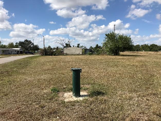
10 Photo 1 Facing East Photo 2 Facing West
11 Attachment 4 Property Data
12 From: To: Cc: Subject: Date: Attachments: Ehrnfelt, Paul James, Kathy Kristin Caruso; Poling, Matt RE: Able Canal Park parcel at 101 Davis Rd. -- REPLY Monday, February 12, :30:28 PM image003.png Kathy, This parcel is not a developed park, but just a vacant unbuildable lot in a residential neighborhood. This is not under the jurisdiction of Parks and Recreation. Mary Nye had this on the County Lands bush hog mowing list as needed. Regards, Paul Paul R. Ehrnfelt Property Acquisition Assistant Department of County Lands Lee County Government, Florida paul.ehrnfelt@leegov.com Fax Only print this if needed. In God We Trust lllllll Please note: Florida has a very broad public records law. Most written communications to or from County Employees and officials regarding County business are public records available to the public and media upon request. Your communication may be subject to public disclosure. Under Florida law, addresses are public records. If you do not want your address released in response to a public records request, do not send electronic mail to this entity. Instead, contact this office by phone or in writing. From: James, Kathy Sent: Monday, February 12, :13 PM To: Ehrnfelt, Paul <PEhrnfelt@leegov.com> Cc: kcaruso@scalarinc.net; Poling, Matt <MPoling@leegov.com> Subject: FW: Able Canal Park parcel at 101 Davis Rd. Paul, would you be able to confirm?
13 Thank you, Kathy James Office Administrator DCD - Code Enforcement KJames@leegov.com Phone: (239) From: Kristin Caruso [mailto:kcaruso@scalarinc.net] Sent: Monday, February 12, :50 PM To: Poling, Matt Cc: James, Kathy Subject: Able Canal Park parcel at 101 Davis Rd. Hello- I m working on the Able Canal PD&E project that is looking at putting a recreational trail along the canal from Harns Marsh to Trailhead park. Part of our environmental review is to identify parks and other recreational/public land. According to the Lee County Property Appraiser map, this parcel is identified as Able Canal Park. I saw your names attached to recent code violations and I am wondering if you can help me- I m not interested in the violations, just interested in knowing if this is really a park for public use, and who maintains it. It just seems to be a vacant lot, perhaps the property appraiser map is incorrect? So far I haven t reached someone at Parks & Rec who knows about it. Thank you- Sincerely, Kristin Kristin A. Caruso, M.S. Environmental Practice Lead, Senior Scientist North 56 th Street Tampa, Florida Office: (813) Cell: (813) kcaruso@scalarinc.net Please note: Florida has a very broad public records law. Most written communications to or from County Employees and officials regarding County business are public records available to the public and media upon request. Your communication may be subject to public disclosure. Under Florida law, addresses are public records. If you do not want your address released in response to a public records request, do not send electronic mail to this entity. Instead, contact this office by phone or in writing.

14 Lee County Property Appraiser - Online Parcel Inquiry Page 1 of 3 2/8/2018 Property Data STRAP: A.0000 Folio ID: Owner Of Record LEE COUNTY PO BOX 398 FORT MYERS FL Site Address 101 DAVIS RD LEHIGH ACRES FL Property Description Do not use for legal documents! LEHIGH ACRES UNIT 20 BLK 9 PARK PARCEL PB 13 PG 37 Classification / DOR Code VACANT GOVERNMENTAL / 80 [ Tax Map Viewer ] [ Pictometry Aerial Viewer ] Current Working Values Image of Structure Just 500 As Of 07/10/2017 Attributes Land Units Of Measure LT Units 1.00 Frontage 0 Depth 0 Total Number of Buildings 0 Total Bedrooms / Bathrooms 0 Total Living Area 0 1st Year Building on Tax Roll 0 Historic District No Property Value History Tax Year Just Market Capped Assessed Assessed Taxable The Just value is the total parcel assessment (less any considerations for the cost of sale). This is the closest value to Fair Market Value we produce and is dated as of January 1st of the tax year in question (F.A.C. 12D-1.002). The Market Assessed value is the total parcel assessment (less any considerations for the cost of sale) based upon the assessment standard. Most parcels are assessed based either upon the Highest and Best Use standard or the Present Use standard (F.S ). For Agriculturally Classified parcels (or parts thereof), only agricultural uses are considered in the assessment (F.S (6) (a)). The difference between the Highest and Best Use/Present Use and the Agricultural Use is often referred to as the Agricultural Exemption. (i.e. Market Assessed = Just - Agricultural Exemption)
15 Lee County Property Appraiser - Online Parcel Inquiry Page 2 of 3 2/8/2018 The Capped Assessed value is the Market Assessment after any Save Our Homes or 10% Assessment Limitation cap is applied. This assessment cap is applied to all properties and limits year-to-year assessment increases to either the Consumer Price Index or 3%, whichever is lower for Homestead properties OR 10% for non- Homestead properties. The Taxable value is the Capped Assessment after exemptions (Homestead, etc.) are applied to it. This is the value that most taxing authorities use to calculate a parcel's taxes. (i.e. Taxable = Capped Assessed - Exemptions) Exemptions Exemption Amount Wholly Values (2017 Tax Roll) Property Values Attributes Just 500 Land Units Of Measure LT Assessed 500 Portability Applied 0 Cap Assessed 500 Taxable 0 Cap Difference 0 Units 1.00 Frontage 0 Depth 0 Total Number of Buildings 0 Total Bedrooms / Bathrooms 0 Total Living Area 0 1st Year Building on Tax Roll 0 Historic District No LEE CO GENERAL REVENUE / 044 Taxing Authorities LEHIGH ACRES FIRE & LIGHT / 048 Name / Code Category Mailing Address County Lee County Office of Management & Budget PO BOX 398 FORT MYERS FL LEE CO ALL HAZARDS PROTECTION DIST / 101 LEE CO LIBRARY DIST / 052 LEE CO UNINCORPORATED MSTU / 020 LEHIGH ACRES STREET LIGHTING UNIT MSTU / 055 LEE CO HYACINTH CONTROL DIST / 051 LEE CO MOSQUITO CONTROL DIST / 053 WEST COAST INLAND NAVIGATION DIST / 098 PUBLIC SCHOOL - BY LOCAL BOARD / 012 PUBLIC SCHOOL - BY STATE LAW / 013 LEHIGH ACRES FIRE CONTROL & RESCUE DIST / 341 Dependent District Dependent District Dependent District Dependent District Independent District Independent District Independent District Public Schools Public Schools Special District Lee County Office of Management & Budget PO BOX 398 FORT MYERS FL Lee County Office of Management & Budget PO BOX 398 FORT MYERS FL Lee County Office of Management & Budget PO BOX 398 FORT MYERS FL LEE COUNTY MSTU / MSBU PO BOX 398 FORT MYERS FL RUSSELL BAKER HOMESTEAD RD LEHIGH ACRES FL RUSSELL BAKER HOMESTEAD RD LEHIGH ACRES FL CHARLES W LISTOWSKI EXECUTIVE DIRECTOR 200 MIAMI AVE E VENICE FL AMI DESAMOURS BUDGET DEPARTMENT 2855 COLONIAL BLVD FORT MYERS FL AMI DESAMOURS BUDGET DEPARTMENT 2855 COLONIAL BLVD FORT MYERS FL ROBERT DILALLO FIRE CHIEF ATTN: ANITA KRESSEL 636 THOMAS SHERWIN AVE S LEHIGH ACRES, FL 33974
16 Lee County Property Appraiser - Online Parcel Inquiry Page 3 of 3 2/8/2018 LEHIGH ACRES MUNICIPAL SERVICES IMPROVEMENT DIST / 350 Special District 601 EAST COUNTY LN LEHIGH ACRES, FL SFWMD-DISTRICT-WIDE / 110 SFWMD-EVERGLADES CONSTRUCTION PROJECT / 084 SFWMD-OKEECHOBEE BASIN / 308 Water District Water District Water District MICHELLE QUIGLEY 3301 GUN CLUB RD WEST PALM BEACH, FL MICHELLE QUIGLEY 3301 GUN CLUB RD WEST PALM BEACH, FL MICHELLE QUIGLEY 3301 GUN CLUB RD WEST PALM BEACH FL Sales / Transactions Sale Price Date OR Number Type Description Vacant/Improved /01/ /85 03 Sales disqualified as a result of examination of the deed Disqualified (Interest Sales / Court Docs / Government) V Parcel Numbering History Prior STRAP Prior Folio ID Renumber Reason Renumber Date Split (From another Parcel) 10/31/2000 Location Information Township Range Section Block Lot 44 27E A 0000 Municipality Latitude Longitude Lee County Unincorporated Links View Parcel on Google Maps View Recorded Plat at LeeClerk.org Use the above link to do an Official Records search on the Lee County Clerk of Courts website, using 10 and 86 for the book and page numbers. View Parcel on GeoView Solid Waste (Garbage) Roll Data Solid Waste District Roll Type Category Unit / Area Tax Amount Service Area 4 R - Residential Category 0.00 Collection Days Garbage Recycling Horticulture Wednesday Wednesday Wednesday Flood and Storm Information Flood Insurance Find my flood zone Storm Surge Zone Community Panel Version Date Evacuation Zone F 8/28/2008 D C Appraisal Details (2017 Tax Roll) Land Land Tracts Use Code Use Code Description Depth Frontage Number of Units Unit of Measure 8000 Vacant Governmental Lot
FLORIDA DEPARTMENT OF TRANSPORTATION SECTION 4(F) DETERMINATION OF APPLICABILITY
 DETERMINATION OF APPLICABILITY") FLORIDA DEPARTMENT OF TRANSPORTATION SECTION 4(F) DETERMINATION OF APPLICABILITY 650-050-45 Environmental Management 06/17 Project Name: Able Canal Pathway from Harns Marsh to Joel Blvd. PD&E Study FM#:
FLORIDA DEPARTMENT OF TRANSPORTATION SECTION 4(F) DETERMINATION OF APPLICABILITY 650-050-45 Environmental Management 06/17 Project Name: Able Canal Pathway from Harns Marsh to Joel Blvd. PD&E Study FM#:
FLORIDA DEPARTMENT OF TRANSPORTATION SECTION 4(F) EXCEPTIONS/EXEMPTIONS DETERMINATION
 EXCEPTIONS/EXEMPTIONS DETERMINATION") FLORIDA DEPARTMENT OF TRANSPORTATION SECTION 4(F) EXCEPTIONS/EXEMPTIONS DETERMINATION 650-050-48 Environmental Management 06/17 Project Name: Able Canal Pathway from Harns Marsh to Joel Blvd. PD&E Study
FLORIDA DEPARTMENT OF TRANSPORTATION SECTION 4(F) EXCEPTIONS/EXEMPTIONS DETERMINATION 650-050-48 Environmental Management 06/17 Project Name: Able Canal Pathway from Harns Marsh to Joel Blvd. PD&E Study
 Page 1 of 5 Property Data for Parcel 29-44-24-C1-00002.0020 TURNBERRY BANK 27200 RIERIEW CENTER BLD STE 309 BONITA SPRINGS FL 34134 RESERED FL PAR IN S1/2 OF N1/2 SEC 29 DESC IN OR 3307 PG 4329 ISLAND
25,000± SF OFFICE/WAREHOUSE WITH LOADING DOCK NEAR I-75
 25,000± SF OFFICE/WAREHOUSE WITH LOADING DOCK NEAR I-75 1681 Baseline Court Fort Myers, FL 33905 For More Information Contact: Paul Sands, Senior Advisor x177 psands@vipcommercial.com or Michael Doyle,
CHAPTER 3: IDENTIFYING SECTION 4(f) PROPERTIES
 PROPERTIES") CHAPTER 3: IDENTIFYING SECTION 4(f) PROPERTIES Section 4(f) and its provisions state that publicly owned parks, recreation areas, wildlife and waterfowl refuges, and publicly and privately owned historic
CHAPTER 3: IDENTIFYING SECTION 4(f) PROPERTIES Section 4(f) and its provisions state that publicly owned parks, recreation areas, wildlife and waterfowl refuges, and publicly and privately owned historic
Property and Ownership Information. Vesting Information. Chain Of Title 1
 E-mail: info@protitleusa.com Phone: (888) 878-8081 Fax: (888) 524-5996 ProTitle Order# 212073 Reference No: Legal Description: COMM SE COR OF SE1/4 OF SW1/4 OF SEC N 89 DEG 38'37"W 466.43 FT RUN N 00 DEG
Former Gas Station 42,500sf - $750,000
 Former Gas Station 42,500sf - $750,000 2065 N Wickham Road Melbourne, FL 32935 Former Gas Station for sale with excellent visibility along Wickham Road 2011 Demographics 1 mile 2 miles 3 miles Total Pop
This is a New Findings of Adequacy for a Recorded Plat (Plat Book 179, Page 131) LAND USE Vacant Effective Plan: Pompano Beach
 LAND USE Vacant Effective Plan: Pompano Beach") Page 1 of 11 Board of County Commissioners, Broward County, Florida Environmental Protection and Growth Management Department Planning and Development Management Division DEVELOPMENT REVIEW REPORT PROJECT
Page 1 of 11 Board of County Commissioners, Broward County, Florida Environmental Protection and Growth Management Department Planning and Development Management Division DEVELOPMENT REVIEW REPORT PROJECT
City of Tarpon Springs, Florida STAFF REPORT
 City of Tarpon Springs, Florida STAFF REPORT July 17, 2018 TO: FROM: PLANNING AND ZONING BOARD MAYOR AND BOARD OF COMMISSIONERS PLANNING AND ZONING DEPARTMENT HEARING DATES: JULY 16, 2018 (PLANNING & ZONING
Section A: General Information for All Activities
 Section A: General Information for All Activities PART 1: NAME, APPLICATION TYPE, LOCATION, AND DESCRIPTION OF ACTIVITY A. Name of project, including phase if applicable: F.B.I. Commercial Park B. This
ACTIVE SAND AND LIMESTONE MINE IN LEE COUNTY FLORIDA
 FOR SALE LAND ACTIE SAND AND LIMESTONE MINE IN LEE COUNTY FLORIDA 21260 State Road 82 Fort Myers, FL 33913 PROPERTY HIGHLIGHTS Fully licensed and operational sand and rock mine in Lee County, Florida Estimated
NOTICE OF INTENT TO USE NPDES GENERIC PERMIT FOR STORMWATER DISCHARGE FROM LARGE AND SMALL CONSTRUCTION ACTIVITIES (RULE (4), F.A.C.
, F.A.C.") NOTICE OF INTENT TO USE NPDES GENERIC PERMIT FOR STORMWATER DISCHARGE FROM LARGE AND SMALL CONSTRUCTION ACTIVITIES (RULE 62-621.300(4), F.A.C.) You must submit this completed Notice of Intent (NOI) form
NOTICE OF INTENT TO USE NPDES GENERIC PERMIT FOR STORMWATER DISCHARGE FROM LARGE AND SMALL CONSTRUCTION ACTIVITIES (RULE 62-621.300(4), F.A.C.) You must submit this completed Notice of Intent (NOI) form
Documentation Standard for an Individual Section 4(f) Evaluation
 Evaluation") Documentation Standard for an Individual Section 4(f) Evaluation Use this documentation standard (DS) to prepare an Individual Section 4(f) evaluation for Federal Highway Administration (FHWA) projects
Documentation Standard for an Individual Section 4(f) Evaluation Use this documentation standard (DS) to prepare an Individual Section 4(f) evaluation for Federal Highway Administration (FHWA) projects
ONE-STEP LIEN SEARCH SUMMARY FORM SW 42nd Street Suite#202 Miami, FL Tel #: (305) or
 or") Page 2 of 16 PROPERTY INFORMATION ONE-STEP LIEN SEARCH SUMMARY FORM 13155 SW 42nd Street Suite#202 Miami, FL 33175 Tel #: (305) 822-9979 or E-Mail: completed@onesteplien.com Client: ROBERT M. CHISHOLM,
Page 2 of 16 PROPERTY INFORMATION ONE-STEP LIEN SEARCH SUMMARY FORM 13155 SW 42nd Street Suite#202 Miami, FL 33175 Tel #: (305) 822-9979 or E-Mail: completed@onesteplien.com Client: ROBERT M. CHISHOLM,
SECTION 4(F) & CHAPTER 26. TxDOT Environmental Conference 2017
 & CHAPTER 26. TxDOT Environmental Conference 2017") SECTION 4(F) & CHAPTER 26 TxDOT Environmental Conference 2017 Table of Contents 1 2 3 4 5 6 7 What s the Difference? Section 4(f) Section 4(f) Exceptions Section 4(f) De Minimis Section 4(f) Documentation
SECTION 4(F) & CHAPTER 26 TxDOT Environmental Conference 2017 Table of Contents 1 2 3 4 5 6 7 What s the Difference? Section 4(f) Section 4(f) Exceptions Section 4(f) De Minimis Section 4(f) Documentation
Florida Department of Environmental Protection
 Florida Department of Environmental Protection Bob Martinez Center 2600 Blair Stone Road Tallahassee, Florida 32399-2400 Rick Scott Governor Carlos Lopez-Cantera Lt. Governor Noah Valenstein Secretary
Truth In Millage (TRIM)
") Truth In Millage (TRIM) The TRIM Notice tells you the taxable value of your property and provides information on proposed millage rates and taxes as estimated by each Hendry County taxing authority which
Truth In Millage (TRIM) The TRIM Notice tells you the taxable value of your property and provides information on proposed millage rates and taxes as estimated by each Hendry County taxing authority which
University of Miami Indoor Practice Facility Development Review Committee (DRC)
") University of Miami Indoor Practice Facility Development Review Committee (DRC) Submitted: February 3, 2017 DRC Meeting Date: February 24, 2017 Table of Contents 1. DRC Application 2. Letter of Intent
University of Miami Indoor Practice Facility Development Review Committee (DRC) Submitted: February 3, 2017 DRC Meeting Date: February 24, 2017 Table of Contents 1. DRC Application 2. Letter of Intent
New Resident Information 2008
 LOCAL GOVERNMENT STRUCTURE Government Structure / Organization Chart ANIMAL LICENSE Lee County Animal Services 5600 Banner Drive, Ft. Myers, FL (239) 432-2083 www.leelostpets.com Mon, Wed, Thur, Fri 8
ONE-STEP LIEN SEARCH SUMMARY FORM SW 42nd Street Suite#202 Miami, FL Tel #: (305) or
 or") Page 2 of 15 PROPERTY INFORMATION ONE-STEP LIEN SEARCH SUMMARY FORM 13155 SW 42nd Street Suite#22 Miami, FL 33175 Tel #: (35) 822-9979 or E-Mail: completed@onesteplien.com Client: ROBERT M. CHISHOLM, P.A.
Page 2 of 15 PROPERTY INFORMATION ONE-STEP LIEN SEARCH SUMMARY FORM 13155 SW 42nd Street Suite#22 Miami, FL 33175 Tel #: (35) 822-9979 or E-Mail: completed@onesteplien.com Client: ROBERT M. CHISHOLM, P.A.
MARTIN COUNTY BOARD OF COUNTY COMMISSIONERS
 MARTIN COUNTY BOARD OF COUNTY COMMISSIONERS 2401 S.E. MONTEREY ROAD STUART, FL 34996 DOUG SMITH Commissioner, District 1 ED FIELDING Commissioner, District 2 ANNE SCOTT Commissioner, District 3 Via Email:
LEE COUNTY RESOLUTION NO.
 LEE COUNTY RESOLUTION NO. A RESOLUTION OF THE BOARD OF COUNTY COMMISSIONERS ESTABLISHING THE ANNUAL RESIDENTIAL AND COMMERCIAL SPECIAL ASSESSMENT CHARGES FOR UNINCORPORATED LEE COUNTY MANDATORY GARBAGE
Witness my hand and official signature at Punta Gorda, Florida this the 9 th day of June, Signature of Property Appraiser
 CC-43 rev. 1/4 I, V. Frank Desguin, the Appraiser of Charlotte County, Florida, hereby certify that all data reported on this form and accompanying forms DR-43AC, DR-43AM, DR-43CC, DR-43BM, DR-43PC, and
THE GROVE GOLF CLUB PLAT
 { MARTIN COUNTY, FLORIDA DEVELOPMENT REVIEW STAFF REPORT A. Application Information THE GROVE GOLF CLUB PLAT Applicant: Hobe Sound Equestrian, LLC Property Owner: Becker B-14 Grove, Ltd Agent for the Applicant:
Ludlam Professional Building 6583 SW 39th Ter, Miami, FL 33155
 Ludlam Professional Building 6583 SW 39th Ter, Miami, FL 33155 Manny Chamizo ONE Sotheby s 1430 S Dixie Hwy,Coral Gables, FL 331463176 FLACommercial@gmail.com (786) 453-3171 Ludlam Professional Building
IMPORTANT ANNOUNCEMENT: Our website is changing! Please click here for details.
 IMPORTANT ANNOUNCEMENT: Our website is changing! Please click here for details. Home Search Downloads Exemptions Agriculture Maps Tangible Links Contact Home Frequently Asked Questions (FAQ) Frequently
FLORIDA DEPARTMENT OF ENVIRONMENTAL PROTECTION
 FLORIDA DEPARTMENT OF ENVIRONMENTAL PROTECTION NOTICE OF INTENT TO USE S. 403.9327, F.S., GENERAL PERMIT FOR MANGROVE TRIMMING OR APPLICATION FOR S. 403.9328, F.S., INDIVIDUAL PERMIT TO TRIM OR ALTER MANGROVES
TAX ROLL CERTIFICATION
 TAX ROLL CERTIFICATION DR-43, R. 6/11 FAC Rule 12D-16.2 I,, the Property Appraiser of County, Florida, certify that all data reported on this form and accompanying forms DR-43V, DR-43CC, DR-43BM, DR-43PC,
TRANSMITTAL MEMORANDUM PROPERTY TAX OVERSIGHT RULES
 PTO TM #15-01 TRANSMITTAL MEMORANDUM PROPERTY TAX OVERSIGHT RULES PURPOSE: This transmittal memorandum contains changes to the Department of Revenue Rules within the Property Tax Oversight Program. RULE
ONE-STEP LIEN SEARCH SUMMARY FORM SW 42nd Street Suite#202 Miami, FL Tel #: (305) or
 or") Page 2 of 16 PROPERTY INFORMATION ONE-STEP LIEN SEARCH SUMMARY FORM 13155 SW 42nd Street Suite#202 Miami, FL 33175 Tel #: (305) 822-9979 or E-Mail: completed@onesteplien.com Client: ROBERT M. CHISHOLM,
Page 2 of 16 PROPERTY INFORMATION ONE-STEP LIEN SEARCH SUMMARY FORM 13155 SW 42nd Street Suite#202 Miami, FL 33175 Tel #: (305) 822-9979 or E-Mail: completed@onesteplien.com Client: ROBERT M. CHISHOLM,
Summary Report $396,383. Sales Information. Previous Sale
 Property Search Application - Miami-Dade County Page 1 of 2 Summary Report EXHIBIT A Generated On : 5/22/2017 Property Information Folio: 01-3135-016-0040 Property Address: 1515 NW S RIVER DR Miami, FL
Village of Palm Springs
 Village of Palm Springs Executive Brief AGENDA DATE: September 28, 2017 DEPARTMENT: Finance ITEM #16: Ordinance No. 2017-23 - (SECOND READING) Establish FY 2017-2018 Millage Rates - Operating & Debt Service
Florida Department of Environmental Protection
 Florida Department of Environmental Protection Bob Martinez Center 2600 Blair Stone Road Tallahassee, Florida 32399-2400 Rick Scott Governor Carlos Lopez-Cantera Lt. Governor Herschel T. Vinyard Jr. Secretary
PROPERTY APPRAISER: 2009 PRELIMINARY ROLL CONFIRMS SIGNIFICANT DECLINE IN VALUES
 FOR IMMEDIATE RELEASE: MEDIA CONTACT: Patrick Smikle: 305-375-4789 PROPERTY APPRAISER: 2009 PRELIMINARY ROLL CONFIRMS SIGNIFICANT DECLINE IN VALUES (MIAMI, July 01, 2009) It s official. The July 1, 2009
Property Tax Oversight Program
 Property Tax Oversight Program Consult the statutory reference before taking action. Dates are due dates or deadlines, unless otherwise stated. Dates that fall on a weekend or holiday are moved to the
Plat/Site Plan Application
 Instructions Plat/Site Plan Application For your application to be officially accepted for processing, you must complete this application in full. The owner/agent certification must be signed and notarized
JOINT APPLICATION FOR INDIVIDUAL ENVIRONMENTAL RESOURCE PERMIT/ AUTHORIZATION TO USE STATE-OWNED SUBMERGED LANDS/ FEDERAL DREDGE AND FILL PERMIT
 Form 62-330.060(1) JOINT APPLICATION FOR INDIVIDUAL ENVIRONMENTAL RESOURCE PERMIT/ AUTHORIZATION TO USE STATE-OWNED SUBMERGED LANDS/ FEDERAL DREDGE AND FILL PERMIT FLORIDA DEPARTMENT OF ENVIRONMENTAL PROTECTION/
Florida Department of Environmental Protection
 Florida Department of Environmental Protection Bob Martinez Center 2600 Blair Stone Road Tallahassee, Florida 32399-2400 Rick Scott Governor Herschel T. Vinyard Jr. Secretary July 25, 2013 Robert Rogers
MARTIN COUNTY PROPERTY APPRAISER LAUREL KELLY, CFA
 MARTIN COUNTY PROPERTY APPRAISER LAUREL KELLY, CFA Fun Facts Real property parcels.... 94,532 Commercial & industrial parcels....3,525 (3.7% of RP parcels) Tangible personal property accounts.. 13,351
City of Coral Gables. Historic Preservation Ad-Valorem Tax Exemption Program
 City of Coral Gables Historic Preservation Ad-Valorem Tax Exemption Program Instructions and Application Coral Gables City Hall Historical Resources Department 2327 Salzedo Street Coral Gables, Florida
EXHIBIT A. City of Corpus Christi Annexation Guidelines
 City of Corpus Christi Annexation Guidelines Purpose: The purpose of this document is to describe the City of Corpus Christi s Annexation Guidelines. The Annexation Guidelines provide the guidance and
History of the Conservation Exemptions
 Conservation Exemptions Agricultural Classification For Property Tax George Wheeler IDP Administrator CUS Florida Dept. of Revenue December 2010 U of F History of the Conservation Exemptions 2008 Florida
Okaloosa County BCC. Okaloosa County BCC. MSBU / MSTU Policy. Municipal Service Benefit Units Municipal Service Taxing Units.
 Okaloosa County BCC Okaloosa County BCC MSBU / MSTU Policy Municipal Service Benefit Units Municipal Service Taxing Units Revised 5/6/2014 Table of Contents INTRODUCTION... 1 MSBU CALENDAR YEAR SCHEDULE...
ESCAMBIA COUNTY MUNICIPAL SERVICES BENEFITS UNITS GUIDELINES AND PROCEDURES
 ESCAMBIA COUNTY MUNICIPAL SERVICES BENEFITS UNITS GUIDELINES AND PROCEDURES Adopted by the Escambia County Board of County Commissioners July 28, 1998 INTRODUCTION The Escambia County Board of County Commissioner's
The applicant is requesting to amend the note to allow for 18 townhouse units in lieu of the commercial use. The requested note reads as follows:
 Page 1 of 27 STAFF REPORT Davie 39 Street Addition 133-MP-83 A request to amend the plat note has been filed with the Planning and Redevelopment Division. This plat was approved by the County Commission
COLLIER COUNTY WAIVER APPLICATION FROM THE REQUIRED HISTORICAL AND ARCHAEOLOGICAL SURVEY AND ASSESSMENT PETITION NUMBER ASSOCIATED WITH THE WAIVER:
 COLLIER COUNTY WAIVER APPLICATION FROM THE REQUIRED HISTORICAL AND ARCHAEOLOGICAL SURVEY AND ASSESSMENT DATE SUBMITTED: PLANNER: PETITION NUMBER ASSOCIATED WITH THE WAIVER: (To Be Completed By Zoning and
Application for 1-d-1 (Open-Space) Agricultural Use Appraisal
 Agricultural Use Appraisal") Application for 1-d-1 (Open-Space) Agricultural Use Appraisal Property Tax Bastrop Central Appraisal District Appraisal District s Name 512-303-1930 Phone (area code and number) P.O. Drawer 578, Bastrop,
Application for 1-d-1 (Open-Space) Agricultural Use Appraisal Property Tax Bastrop Central Appraisal District Appraisal District s Name 512-303-1930 Phone (area code and number) P.O. Drawer 578, Bastrop,
IRC INTERNATIONAL REALTY CORPORATION
 Rental Rate: $16/SF 3480 Pelican Colony Blvd., Estero, Florida 34134 IRC INTERNATIONAL REALTY CORPORATION 3838 Tamiami Trail North, Suite 416 Naples, FL 34103 (P) 239.213.4000 rainer@inter-realty.com www.inter-realty.com
MUNICIPAL SERVICE BENEFIT UNIT (MSBU) CREATION AND ADMINISTRATION POLICY 16-01
 CREATION AND ADMINISTRATION POLICY 16-01") MUNICIPAL SERVICE BENEFIT UNIT (MSBU) CREATION AND ADMINISTRATION POLICY 16-01 PURPOSE: POLICY: The purpose of this policy is to provide an orderly and efficient method for utilizing the statutory authority
MUNICIPAL SERVICE BENEFIT UNIT (MSBU) CREATION AND ADMINISTRATION POLICY 16-01 PURPOSE: POLICY: The purpose of this policy is to provide an orderly and efficient method for utilizing the statutory authority
DOING BUSINESS IN SARASOTA COUNTY E C O N O M I C D E V E L O P M E N T
 DOING BUSINESS IN SARASOTA COUNTY E C O N O M I C D E V E L O P M E N T 2013 SILVER DOING BUSINESS IN SARASOTA COUNTY E C O N O M I C D E V E L O P M E N T OFFICE OF BUSINESS AND ECONOMIC DEVELOPMENT Doing
Section I Notices of Development of Proposed Rules and Negotiated Rulemaking
 Section I Notices of Development of Proposed Rules and Negotiated Rulemaking DEPARTMENT OF AGRICULTURE AND CONSUMER SERVICES Division of Forestry 5I-7.001 Rural and Family Lands Protection Program PURPOSE
2016 FUTURE LAND USE ATLAS AMENDMENT APPLICATION. Palm Beach County Planning Division 2300 North Jog Road, WPB, FL 33411, (561)
") I. Amendment Data 2016 FUTURE LAND USE ATLAS AMENDMENT APPLICATION Palm Beach County Planning Division 2300 North Jog Road, WPB, FL 33411, (561) 233-5300 Round 18-B Intake Date August 4, 2017 Application
I. Amendment Data 2016 FUTURE LAND USE ATLAS AMENDMENT APPLICATION Palm Beach County Planning Division 2300 North Jog Road, WPB, FL 33411, (561) 233-5300 Round 18-B Intake Date August 4, 2017 Application
 Page 1 of 10 Manny Chamizo III Commercial Director Fortune International Realty 2401 Douglas Rd, Miami Fl 33145 P: 305-460-6714 F: 305-722-3694 C: 786-486-6655 Flacommercial@aol.com www.therebroker.com
6801 PALISADES PARK COURT SUITE 2 FT MYERS, FL Phone: PROPERTY ADDRESS: 2863 NW 12 CT, FORT LAUDERDALE FL
 *831258* SOLD TO: CLIENT ID: 335 T.R. Title 3325 Hollywood Blvd Ste 32 Hollywood, Florida 3321 ATTN: LIDIA EMAIL: PROCESSOR@TRTITLE.COM COST BREAKDOWN FOR INVOICE 831258: QUANTITY 1 Standard Lien Search
COMMUNITY OPTION STUDY
 CASEY KEY COMMUNITY OPTION STUDY December 3, 2008 Prepared for Mr. George Scantland Casey Key Committee to Study Incorporation Prepared by Fishkind & Associates, Inc. 12051 Corporate Boulevard Orlando,
LLANO COUNTY, TEXAS. Closed and Abandoned Landfill Inventory UPDATE
 LLANO COUNTY, TEXAS Closed and Abandoned Landfill Inventory UPDATE Prepared by the: Capital Area Council of Governments 2010 CLOSED LANDFILL INVENTORY BASIC IDENTIFYING INFORMATION A. COG Name: Capital
THE GROVE GOLF CLUB PLAT
 { MARTIN COUNTY, FLORIDA DEVELOPMENT REVIEW STAFF REPORT A. Application Information THE GROVE GOLF CLUB PLAT Applicant: Hobe Sound Equestrian, LLC Property Owner: Becker B-14 Grove, Ltd Agent for the Applicant:
TAX ROLL CERTIFICATION FLORIDA DEPARTMENT OF REVENUE
 DR-489, R. 6/11 TAX ROLL CERTIFICATION I,, Property Appraiser of County certify that: The real property tax roll of this county and that of the taxing authorities therein, included in these recapitulations,
Lee County Site Selection Website
 Lee County Site Selection Website http://leegis.leegov.com/siteselection Businesses: Businesses: 2012 Occupational Licenses Based on information from Lee County Tax Collector, City of Cape Coral and City
Florida Department of Environmental Protection
 Florida Department of Environmental Protection Bob Martinez Center 2600 Blair Stone Road Tallahassee, Florida 32399-2400 Rick Scott Governor Herschel T. Vinyard Jr. Secretary July 05, 2013 Robert G. Choquette,
9701 Chemstrand Road, Unincorporated Escambia County, Florida
 Escambia County, Florida Request for Local Government Contribution ($37,500) Florida Housing Finance Corporation RFA 2016-110: Small/Medium County 9% HC NAME OF DEVELOPMENT: PROPERTY ADDRESS: Patricia
C i t y o f C o r a l G a b l e s P l a n n i n g a n d Z o n i n g S t a f f R e p o r t
 C i t y o f C o r a l G a b l e s P l a n n i n g a n d Z o n i n g S t a f f R e p o r t Applicant: Application: Property: Mario Garcia-Serra Variance 944 Lugo Avenue BA-17-09-1073 Legal Description:
Application for 1-d-1 (Open-Space) Agricultural Use Appraisal
 Agricultural Use Appraisal") HUNT COUNTY APPRAISAL DISTRICT 4801 King Street PO Box 1339 Greenville, Texas 75403 1339 Phone: 903 454 3510 Fax: 903 454 4160 Application for 1-d-1 (Open-Space) Agricultural Use Appraisal State the Year
HUNT COUNTY APPRAISAL DISTRICT 4801 King Street PO Box 1339 Greenville, Texas 75403 1339 Phone: 903 454 3510 Fax: 903 454 4160 Application for 1-d-1 (Open-Space) Agricultural Use Appraisal State the Year
A. General Information
 Important: When filling out forms on the computer, use only the tab key to move your cursor - do not use the return key. Massachusetts Department of Environmental Protection A. General Information 1. Project
JOINT PUBLIC NOTICE PUBLIC NOTICE
 Albuquerque District JOINT PUBLIC NOTICE PUBLIC NOTICE Application Number: SPA-2012-00299-ABQ Date: October 20, 2014 Comments Due: November 20, 2014 SUBJECT: The U.S. Army Corps of Engineers, Albuquerque
To: Property Appraisers, Taxing Authorities and Interested Parties From: James McAdams Date: June 5, 2012 Bulletin: PTO 12-04
 Property Tax Oversight Bulletin: PTO 12-04 To: Property Appraisers, Taxing Authorities and Interested Parties From: James McAdams Date: Bulletin: PTO 12-04 FLORIDA DEPARTMENT OF REVENUE PROPERTY TAX INFORMATIONAL
Florida Department of Environmental Protection
 Florida Department of Environmental Protection Bob Martinez Center 2600 Blair Stone Road Tallahassee, Florida 32399-2400 Charlie Crist Governor Jeff Kottkamp Lt. Governor Michael W. Sole Secretary August
CITY OF RIALTO PLANNING DIVISION ENTITLEMENT APPLICATION
 ENTITLEMENT APPLICATION LEGAL OWNER INFORMATION: I hereby certify that I am (we are) the record owner(s) for property tax assessment purposes of the property encompassed by this application. I understand
Portability. Upsize. Market/Just Value* $600,000 Less Portability Benefit -150,000 Assessed Value* $450,000 Less Homestead Exemption -50,000
 Please contact our office for details. Property Appraiser Hillsborough County, Florida www.hcpafl.org 813-272-6100 Portability benefit amount is the difference between market/just value* and assessed value
CITY OF RIALTO PLANNING DIVISION
 ENTITLEMENT APPLICATION LEGAL OWNER PROPERTY INFORMATION: I hereby certify that I am (we are) the record owner(s) for property tax assessment purposes of the property encompassed by this application. I
Redington Shores, Florida. For more information: John Burpee Gulf Boulevard Redington Shores, FL 33708
 THE LONG PIER 17490 Gulf Boulevard Redington Shores, FL 33708 Redington Shores, Florida For more information: John Burpee 727-585-2070 John@naitampabay.com 11683 87th Street N Largo, FL 33773 727 585 2070
Florida Department of Environmental Protection
 Florida Department of Environmental Protection Bob Martinez Center 2600 Blair Stone Road Tallahassee, Florida 32399-2400 Rick Scott Governor Carlos Lopez-Cantera Lt. Governor Jonathan P. Steverson Secretary
Section 4(f) Why don t we build the road through this green space over here?
 Why don t we build the road through this green space over here?") Section 4(f) Why don t we build the road through this green space over here? Objectives Section 4(f) What is Section 4(f)? understand the basics of the law and applicability; Is this a Section 4(f) situation?--develop
Section 4(f) Why don t we build the road through this green space over here? Objectives Section 4(f) What is Section 4(f)? understand the basics of the law and applicability; Is this a Section 4(f) situation?--develop
APPLICATION FOR EXEMPT SUBDIVISION: NON-LOT SPLIT
 APPLICATION FOR EXEMPT SUBDIVISION: NON-LOT SPLIT ELIGIBILITY Section 12.08.03.c of the Land Development Code provides for review and approval of exempt subdivisions, which shall include any of the following:
PROPERTY QUICK FACTS
 PROPERTY QUICK FACTS Property Type: Location: Herbie s Bar & Chowder House 635 Overseas Highway Marathon, Florida 335 Alternate Key #: 141442 Parcel ID #: 33638-217 Tax Bill: $7,791.95 Site Size SF: Building
Alvarez Engineers, Inc.
 FL Certificate of Authorization No. 7538 10305 NW 41 Street Suite 103 Doral, Florida 33178 Tel. (305) 640-1345 Fax (305) 640-1346 E-Mail: Juan.Alvarez@AlvarezEng.com July 30, 2014 Ms. Cathy Deckert District
WHY ACTION IS NECESSARY: The Board must formally accept all real estate conveyances to Lee County
 Agenda Item Summary Blue Sheet No. 20040062 1. REQUESTED MOTION: Authorize: (1) approval of Resolution expressing an interest in accepting a donation of surplus land owned by the Florida Department of
City of Port St. Lucie PLANNING & ZONING DEPARTMENT
 City of Port St. Lucie PLANNING & ZONING DEPARTMENT EXEMPTION FROM PLATTING Section: 156.022 Process Fill out: Exemption From Platting Application Form. See Fee Schedule for fee. Submit to Planning & Zoning
40 +/- Acres Cornerstone Group- Colonial Boulevard 40 Acres Section 32, Township 44, Range 25. For Cornerstone Group. Prepared by
 DUE DILIGENCE REPORT 40 +/- Acres Cornerstone Group- Colonial Boulevard 40 Acres Section 32, Township 44, Range 25 For Cornerstone Group Prepared by David Douglas Associates, Inc. 2037 West First Street
2835 Overpass Road, Tampa, FL 33619
 2835 Overpass Road, Tampa, FL 33619 FOR SALE $6,1, LEASE $4.95 PSF NNN BLDG 3 4,55 SF BLDG 1 87,19 SF 11.22 Acres BLDG 2 OFFICE 5,88 SF 3 building complex on 11.22 paved and fenced acres. Covered loading
LAND DEVELOPMENT CODE NATURAL RESOURCES PERMIT APPLICATION INFORMATION PACKET
 LAND DEVELOPMENT CODE NATURAL RESOURCES PERMIT APPLICATION INFORMATION PACKET The Hillsborough County Board of County Commissioners Adapted Lobbying Ordinance No. 93-8, as amended. Prior to meeting privately
City of Plantation Mayor s Council
 City of Plantation Mayor s Council October 12, 2017 Diane Veltri Bendekovic, Mayor Plantation Community Center Dedicated August 2017 Welcome Agenda General Fund Budget highlights Ad Valorem Bond update
Special exception for a garage apartment on Transitional Agriculture/Enterprise Community Overlay/Low Impact Urban (A- 3E(1)) zoned property.
) zoned property.") GROWTH AND RESOURCE MANAGEMENT DEPARTMENT PLANNING AND DEVELOPMENT SERVICES DIVISION CURRENT PLANNING ACTIVITY 123 W. Indiana Avenue, Room 202, DeLand, FL 32720 (386) 943-7059 PUBLIC HEARING: CASE NO:
GROWTH AND RESOURCE MANAGEMENT DEPARTMENT PLANNING AND DEVELOPMENT SERVICES DIVISION CURRENT PLANNING ACTIVITY 123 W. Indiana Avenue, Room 202, DeLand, FL 32720 (386) 943-7059 PUBLIC HEARING: CASE NO:
Walton County Planning and Development Services
 Walton County Planning and Development Services 31 Coastal Centre Boulevard, Suite 100 47 N 6 th Street Santa Rosa Beach, Florida 32459 DeFuniak Springs, Florida 32433 Phone 850-267-1955 Phone 850-892-8157
NATIONAL REGISTER NOMINATION CHECK-OFF LIST (Revised )
") Office of Archaeology and Historic Preservation History Colorado Publication #1413a NATIONAL REGISTER NOMINATION CHECK-OFF LIST (Revised 2-2015) This check-off list is to insure that all necessary materials
Office of Archaeology and Historic Preservation History Colorado Publication #1413a NATIONAL REGISTER NOMINATION CHECK-OFF LIST (Revised 2-2015) This check-off list is to insure that all necessary materials
5004 N Bay Rd, Miami Beach, FL 33140
 PROPERTY REPORT 5004 N Bay Rd, Miami Beach, FL 33140 Presented by Christopher Lazaro Florida Real Estate License: BK3252123 Hello & Happy New Year! You may call me any time to discuss your Residential
 escpadetail 4141 PINE FOREST RD 32533 http://www.escpa.org/cama/detail_a.aspx?s=021s314402000001 Page 1 of 2 10/17/2016 ECPA Home Real Estate Search Tangible Property Search Sale List Amendment 1/Portability
DEPARTMENT OF COMMUNITY DEVELOPMENT Case # APPLICATION & CHECKLIST FOR CUL-DE-SAC VARIANCE Questions:
 Please note that any advisory comments provided by staff regarding approval or permits are conceptual only and are subject to change. Official review may result in additional changes not noted in the advisory
Application for 1-d-1 (Open-Space) Agricultural Use Appraisal Property Tax LCAD Form
 Agricultural Use Appraisal Property Tax LCAD Form") Application for 1-d-1 (Open-Space) Agricultural Use Appraisal Property Tax LCAD Form 1-2013 Limestone County Appraisal District 254-729-3009 Appraisal District s Name P. O. Drawer 831, Groesbeck, Texas
Application for 1-d-1 (Open-Space) Agricultural Use Appraisal Property Tax LCAD Form 1-2013 Limestone County Appraisal District 254-729-3009 Appraisal District s Name P. O. Drawer 831, Groesbeck, Texas
Application for 1-d-1 (Open-Space) Agricultural Appraisal For 2017
 Agricultural Appraisal For 2017") Walker County Appraisal District P.O. Box 1798 1819 Sycamore Avenue Huntsville, TX 77342-1798 Phone: Fax: 936-295-0402 936-295-3061 Granted: Date: / / Denied: Date: / / Application for 1-d-1 (Open-Space)
Walker County Appraisal District P.O. Box 1798 1819 Sycamore Avenue Huntsville, TX 77342-1798 Phone: Fax: 936-295-0402 936-295-3061 Granted: Date: / / Denied: Date: / / Application for 1-d-1 (Open-Space)
TOLEDO BLADE COMMERCIAL OUTPARCELS acres, City of North Port, FL Bank Owned
 Offering Memorandum TOLEDO BLADE COMMERCIAL OUTPARCELS 14.41 acres, City of North Port, FL Bank Owned www.yatesandcompany.net TOLEDO BLADE COMMERCIAL OUTPARCELS Disclaimer: While the information contained
MIAMI SHORES VILLAGE PERMIT PROCESS 101
 MIAMI SHORES VILLAGE PERMIT PROCESS 101 Ismael Naranjo, BO, CFM Building Director 305-795-2204 bo@msvfl.gov Welcome Introduction Tom Benton Village Manager 305-762-4851 bentont@msvfl.gov Who Does What?
$4, Sale Date Book/Page Inst. Type Sale VImp Sale Qual Sale RCode Sale Price
 D_SearchResults 9/20/12 6:29 PM Okeechobee County Property Appraiser CAMA updated: 9/20/2012 Parcel: 1-05-37-35-0020-00170-0200 > 2012 Proposed Values Parcel List
COUNTY OF KANE. Supervisor of Assessments Geneva, Illinois Holly A. Winter, CIAO/I (630)
") COUNTY OF KANE COUNTY ASSESSMENT OFFICE County Government Center Mark D. Armstrong, CIAO 719 Batavia Avenue, Building C Supervisor of Assessments Geneva, Illinois 60134-3000 Holly A. Winter, CIAO/I (630)
COUNTY OF KANE COUNTY ASSESSMENT OFFICE County Government Center Mark D. Armstrong, CIAO 719 Batavia Avenue, Building C Supervisor of Assessments Geneva, Illinois 60134-3000 Holly A. Winter, CIAO/I (630)
A. General Information
 Important: When filling out forms on the computer, use only the tab key to move your cursor - do not use the return key. Massachusetts Department of Environmental Protection A. General Information 1. Project
Planning Division Case Report VP
 Planning Division Case Report VP 17-0018 Review Date: December 11, 2017 Applicant/ Property Owner: Frank Morris, Trustee of the Frank Morris Trust dated August 27, 2003 Owner Address: Request: Property
CITY OF SURREY BY-LAW NO THE CITY COUNCIL of the City of Surrey, in open meeting assembled, ENACTS AS FOLLOWS:
 CITY OF SURREY BY-LAW NO. 16452 A by-law to amend Surrey Zoning By-law, 1993, No. 12000, as amended THE CITY COUNCIL of the City of Surrey, in open meeting assembled, ENACTS AS FOLLOWS: Surrey Zoning By-law,
LAKE WORTH DRAINAGE DISTRICT OPERATING POLICIES TABLE OF CONTENTS
 LAKE WORTH DRAINAGE DISTRICT OPERATING POLICIES TABLE OF CONTENTS Chapter 1: Chapter 2: Chapter 3: Introduction Fees Engineering & Permitting Requirements Sec. 3.1 Sec. 3.2 Sec. 3.3 Sec. 3.4 Sec. 3.5 Sec.
Dedicated program for municipal drainage management
 Dedicated program for municipal drainage management Street drainage evaluation and repairs Maintenance of pipes and drainage structures Mowing, debris and vegetation removal Erosion control and re-grading
COMPREHENSIVE PLAN FUTURE LAND USE MAP AMENDMENT APPLICATION
 COUNTY STAFF DATA ONLY Date Received: Project No. CPA-20 - GADSDEN COUNTY DEPARTMENT OF PLANNING & COMMUNITY DEVELOPMENT 1-B East Jefferson Street, Post Office Box 1799, Quincy, FL 32353-1799 PLANNING