|
|
|
- Gerald Adams
- 5 years ago
- Views:
Transcription
1
2
3
4
5
6
7 Section March 2008 Protocol Provision (Protocol Text Excerpt) Interpretation of DTSC Protocol Requirements, Definitions and Implementation Guidance Paragraph 1 This Protocol is intended for areas where a 100 percent clearance, using best available detection technology, has been completed. General Comments: The Protocol was developed for entities proposing residential use within former munitions response sites (MRS) where munitions presenting a hazard are known or suspected to have been used and a 100 percent clearance, using best available detection technology (BADT) has been completed. A 100 percent clearance using (BADT) will be considered to have been completed if the entity can document that a removal action has been implemented using a detection technology capable of detecting the munitions of concern and the detector was deployed correctly across 100 percent of the available surface area of the MRS. Digital geophysical mapping using electromagnetic detectors was widely accepted as BADT at the time the protocol was developed and EM61 was the predominate detector of choice. Specific comments: The Protocol does not reference the Fort Ord Track designations but the Protocol would need to be implemented on a Track 2 site (munitions response was conducted). Specifically the munitions response conducted would have to have been a 100% BADT clearance. If an analog munitions response was a 100% clearance determined by DTSC to be BADT the Protocol can be implemented. DTSC uses a Lines-of-Evidence approach in determining specific areas within a residential parcel subject to Section 2.0 (Additional Clearance Protocol for Residential Use Areas) of the DTSC Protocol. Data evaluated for the purpose of this designation includes, but is not necessarily limited to, historical records, site walks, surface removals, subsurface investigations, and subsurface removals. o o Based on the data evaluation, the areas subject to this DTSC Protocol are determined with the following guidelines: Areas demonstrated to meet the Fort Ord Track 0 designation do not require additional evaluation under this DTSC Protocol. Track 0 areas are defined as areas that contain no evidence of MEC and areas not suspected as having been used for munitions-related activities of any kind. Discoveries of incidental munitions items that are not indicative of past military training activities does not disqualify an area from being considered for Track 0. Areas demonstrated to meet the Fort Ord Track 1 designation do not require additional evaluation under this DTSC Protocol. Track 1 sites are sites where military munitions were suspected to have been used, but based on the RI/FS for each site, the site falls into one of the following categories: Category 1 There is no evidence to indicate military munitions were used at the site (i.e., suspected training did not occur). Category 2 The site was used for training, but the military munitions items used do not pose an explosive hazard (i.e., training did not involve explosive items). o Category 3 The site was used for training with military munitions, but military munitions items that potentially remain as a result of that training do not pose an unacceptable risk based on site-specific evaluations conducted in the Track 1 MR RI/FS. Field investigations identified evidence of past training involving military munitions, but training at these sites involved only the use of practice and/or pyrotechnic items that are not designed to cause injury. In the unlikely event that a live item of the type previously observed at the site is found, it is not expected that the item would function by casual contact (i.e., inadvertent and unintentional contact). DTSC determines the site-specific Best Available Detection Technology (BADT) based on the technology available at the time of the clearance action, type and size of munitions potentially present at the site, expected munitions depths, accessibility (i.e., terrain, trees, and vegetation), soil conditions and cultural interference. The determination of BADT is based on the following guidelines: EM61 MkII is considered to be BADT for DGM removal actions. Analog hand-held detectors (i.e. Schonstedt magnetometer) are considered to be BADT for removal actions in areas where EM61MkII prior to approval of EM61 MkII for DGM removals at the former Fort Ord, analog hand-held detectors (i.e. Schonstedt magnetometer) are considered to be BADT when used with 5-foot search lanes and appropriate QC/QA. FORA ESCA RP Team Page 1 of 8 27 November 2013
8 Table 1 DRAFT Identification of DTSC March 2008 Residential Protocol Requirements and Implementation Guidance Section March 2008 Protocol Provision (Protocol Text Excerpt) Interpretation of DTSC Protocol Requirements, Definitions and Implementation Guidance This Protocol sets forth the procedure under which the jurisdictional entity shall remove vegetation and soil, and scan the new surface for metallic items on certain parcels. General Comment: The protocol prescribes required procedures (i.e., remove vegetation and soil) to overcome technical challenges to removing munitions of concern risk to levels acceptable for residential use. Vegetation, anomaly clutter, geology, terrain and detection depths pose challenges to BADT. The removal of vegetation and soil, and subsequent scan of the new surface is a method for overcoming technical challenges. These parcels may be used for residential purposes if the Department of Toxic Substances Control (DTSC) has concurred that the protocol was successfully and correctly implemented. This statement presents a goal of the DTSC Protocol; therefore, no specific field requirements are identified for evaluation. use is impractical (i.e., steep terrain and heavily treed areas) and the munitions of concern are within the detection capability of the hand-held instrument. For removal actions conducted No interpretation necessary. General Comment: It is the proponent s responsibility to demonstrate that technical challenges have been removed and munitions do not pose an unacceptable risk to residential use. Parcels for which the protocol has been successfully and correctly implemented ("Residential Use Areas") shall continue to be subject to land use covenants restricting residential use, until the covenant is removed, modified or a variance is granted by the DTSC. The residential use restriction is to remain until the CRUP is removed, modified, or a variance is granted by DTSC. DTSC can and will remove the residential restriction upon successful completion of the DTSC Protocol. Specific Comment: The Jurisdiction must request DTSC to remove the residential restriction. The parcels shall also continue to be subject to local digging ordinances as well as agreements with DTSC. Parcels designated as acceptable for future residential reuse are subject to appropriate institutional controls and agreements with DTSC. At the former Fort Ord, appropriate institutional controls include such things as local excavation and digging ordinances, construction support, deed restrictions, and disclosures. Paragraph 2 Project proponents will submit a work plan proposing compliance with this Protocol, disposition of removed soil, etc., for DTSC approval. Specific Comment: The work plan will detail activities and procedures to be used in site-specific implementation and to begin application of the DTSC Protocol. This DTSC Protocol is to be implemented under a DTSC-approved work plan. The work plan will detail activities and procedures to be used in site-specific implementation and to complete application of the DTSC Protocol. FORA ESCA RP Team Page 2 of 8 27 November 2013
9 Table 1 DRAFT Identification of DTSC March 2008 Residential Protocol Requirements and Implementation Guidance Section March 2008 Protocol Provision (Protocol Text Excerpt) Interpretation of DTSC Protocol Requirements, Definitions and Implementation Guidance According to the Track 2 Del Rey Oaks Record of Decision, the Army was not able to complete clearance of the range 26 berm area (11 grids) below the depth of four feet. If this reuse is proposed for residential use, the work plan should include resolution of this issue. This provision is specific to Del Rey Oaks; therefore, no interpretation is appropriate. Paragraph 3 General Comment: Site specific characteristics such as vegetation, anomaly clutter, geology, terrain and detection depths pose challenges to BADT and need to be identified and addressed in the protocol work plan. For purposes of this Protocol, the current Department of Defense Munitions Response Terminology for sites impacted by ordnance will be used. Specifically, MEC refers to Munitions and Explosives of Concern, and MD refers to Munitions Debris. For this document, MD and MEC-like items shall be defined as metal items with any dimension 2 inches or larger, as defined in the Protocol Work Plan. Encountering MD or MEC-like items with largest diameter less than 2 inches or encountering large cultural artifacts such as utility lines or vaults, that would have been intentionally left in place during prior investigations, will not be counted as MD or MEC-like. General comments: MD and MEC-like items shall be defined on a site specific case and be supported by historic information to include data gained from the 100 % BADT removal. Typically MD and MEC-like items exhibit similar sensor responses and or physical properties to MEC. Encountering MD or MEC like anomalies in the application of the protocol will require an evaluation to determine if MD or MEC like anomalies are evidence of detection challenges and or that a munitions hazard exists. Specific comment: The Fort Ord Track definitions are not necessarily applicable to the Protocol Current DoD Munitions Response Terminology defines MEC and MD as follows: MEC - A term distinguishing specific categories of military munitions that may pose unique explosives safety risks: UXO, as defined in 10 U.S.C. 101(e)(5)(A) through (C); Discarded military munitions (DMM), as defined in 10 U.S.C. 2710(e)(2); or Munitions constituents (e.g., TNT, cyclotrimethylenetrinitramine [RDX]), as defined in 10 U.S.C. 2710(e)(3), present in high enough concentrations to pose an explosive hazard. Munitions Debris (MD) - Remnants of munitions (e.g., fragments, penetrators, projectiles, shell casings, links, fins) remaining after munitions use, demilitarization, or disposal. Items to be counted during implementing of Additional Clearance Protocol include MEC and MD as defined in current DoD Munitions Response Terminology and MEC-like items ( items to be counted ). MEC-like items are defined as metal items (i.e., other debris) of sufficient size, shape and weight as to resemble intact MEC items. The following items will not be counted as MD or MEC-like under this DTSC Protocol: MD and MEC-like items smaller than 2 inches in all dimensions MD and MEC-like items with largest diameter less than 2 inches Large cultural artifacts, such as utility lines, intentionally left in place during prior investigations The following MEC and MD items that meet the Fort Ord Track 1 criteria for No Further Action (NFA) will not be counted as MEC or MD under this DTSC Protocol: MEC or MD from military munitions items that do not pose as explosive hazard (i.e., hazard code 0) [Track 1 Category 2] MEC or MD present as a result of training but do not pose an unacceptable risk based on site-specific evaluation conducted in the Track 1 MR RI/FS [Track 1 Category 3] MEC or MD from training involving military munitions used for practice and/or pyrotechnic items that are not designed to cause injury (i.e., hazard code 0). In the unlikely event that a live item of the type previously observed at the site is found, it is not expected that the item would function by casual contact (i.e., inadvertent or unintentional contact). [Track 1 Category 3] 1.0 Defined Property Boundaries. FORA ESCA RP Team Page 3 of 8 27 November 2013
10 Table 1 DRAFT Identification of DTSC March 2008 Residential Protocol Requirements and Implementation Guidance Section March 2008 Protocol Provision (Protocol Text Excerpt) Interpretation of DTSC Protocol Requirements, Definitions and Implementation Guidance 1.0 This Protocol may be applied within defined legal parcels, or property boundaries that have been surveyed and for which a legal description has been developed, within the former Fort Ord lands. No interpretation necessary. 2.0 Additional Clearance Protocol for Residential Use Areas. 2.1 Top, 6" to 12"of surface soils shall be removed and stockpiled, and may not be used within Residential Use Areas without prior approval from DTSC. General Comment: Detection challenges may exist when expected depths of munitions of concern cannot be adequately detected with BADT. A 6 to 12 inch lift is typically a practical increment of soil removed to increase detection depths required to adequately characterize munitions risk. Residential reuse areas identified by DTSC as requiring Additional Clearance Protocol are subject to the following: Remove 6 to 12 soil lift and stockpile soil outside of residential reuse area DTSC considers ESCA RQA Baseline Survey using lowered EM-61 MkII coils as equivalency to 6 to 12 soil lift and rescan. Lowering of EM-61 MkII coils 8 in the ESCA sled has been demonstrated to achieve detection performance equivalent to rescanning after a 6-12 soil lift (Preliminary Draft RQA Pilot Study Report, 2010). Specific Comment: Variances to the Protocol such as use of the ESCA sled are evaluated on a site specific case. Construction monitoring, as prescribed by local digging ordinances and/or agreements with DTSC, shall be implemented during this clearing and grubbing activity. Specific Comment: Sifting or screening of excavated soil lifts is not required under this DTSC Protocol, but may be the most feasible process to implement the Protocol. Construction monitoring, as described by digging ordinances and/or agreements with DTSC, is required during soil vegetation clearing and grubbing and soil excavation activities. Construction monitoring consists of UXO Qualified personnel providing on-site monitoring of vegetation removal and soil excavation activities, and conducting instrument-aided visual inspection of new soil surface and soil stockpiles with the following guidelines: If MEC is found during construction support, work must stop until MEC is addressed (see Paragraph 2.7) If indications that MEC may remain within soil lift being stockpiled, the Army must be contacted (see Paragraph 2.7) Sifting or screening of excavated soil lifts is not required under this DTSC Protocol No soil may be removed from the property boundary without prior written approval from DTSC. In addition, removed soil (from grubbing, grading lifts or cuts) may not be used in any residential area. Written permission must be obtained from DTSC to remove soil from property. Removed soil may not be used in any residential area. FORA ESCA RP Team Page 4 of 8 27 November 2013
11 Table 1 DRAFT Identification of DTSC March 2008 Residential Protocol Requirements and Implementation Guidance Section March 2008 Protocol Provision (Protocol Text Excerpt) Interpretation of DTSC Protocol Requirements, Definitions and Implementation Guidance 2.2 Areas where the top 6"-12" inches of soil has been removed pursuant to Section 2.1 above shall be rescanned using the EM61 Mark 2 (digital) technology, and the field deployment and quality assurance/quality control procedures documented in the following referenced document, unless an alternate methodology has been previously approved by DTSC. USA Environmental [2001] Final 100 percent Grid Sampling 4" OE Removal, After Action Report, Inland Range Contract, Former Fort Ord, California; Site MRS-15, Seaside 1-4, MRS-15DR0.02 and MoCo 1 & 2, October 13, Specific Comment: Variances to the Protocol such as use of the ESCA sled are evaluated on a site specific case and subject to a variance. The USA document is referenced to be used as a baseline for QA/QC. DTSC will require QA/QC procedures be consistent with best available and current practices. 2.3 Soil grade cuts which exceed a depth of 5 feet below original ground surface will not require a scan utilizing the EM61Mark2 (digital) technology or alternate methodology. The new surface of these cuts will require construction monitoring utilizing an analog instrument, such as the Schonstedt GA 52CX, or similar instrument approved by DTSC. The instrument will be operated along a random pathway throughout the area of the cut. Documentation of this procedure being conducted will be provided to DTSC. General Comment: When the proponent can demonstrate that soil cuts exceed verifiable munitions penetration depths, a variance to the protocol may be granted. Soil management plans for protocol variances will need to have DTSC approval. Rescan of 6 to 12 soil lift area is to be performed with EM-61 MkII DGM technology with the following guidelines: DTSC requires EM-61 MkII DGM anomaly selection criteria (i.e., threshold) based on 37mm projectile at 12 below-ground-surface (bgs) DTSC considers DGM mapping of original ground surface using lowered EM-61 MkII coils (i.e., ESCA Sled) as equivalency to rescanning the area (i.e., 37mm at 18 bgs) (Preliminary Draft RQA Pilot Study Report, 2010) The After Action Report [AR OE-0338] referenced in the DTSC Protocol includes field investigations utilizing analog hand-held magnetic locator (i.e., Schonstedt GA-52Cx). As such, the following interpretations have been made: DTSC considered USA Environmental field methodologies and Schonstedt GA-52Cx to be BADT in 1999 when referenced field work was accomplished DTSC currently considers EM-61 MkII digital geophysical mapping technology to be BADT Field deployment of EM61 MkII DGM under this DTSC Protocol must be documented in an approved work plan and utilize current former Fort Ord standard operating procedures (SOPs) and quality assurance / quality control (QA/QC) requirements If site grading is conducted prior to or during implementation of this DTSC Protocol, then areas where grade cuts (i.e., soil excavation) exceed 5 below original ground surface do not require DGM rescan under Paragraph 2.2. DTSC s alternate requirements for grade cuts which exceed 5 below original ground surface include the following provisions: Construction monitoring is performed during grade excavation and soil stockpiling or laydown Rescanning is performed in the final cut grade utilizing analog instruments along a random pathway throughout the area. 2.4 Areas scanned pursuant to Section 2.2 or receiving construction monitoring pursuant to Section 2.3 for which no additional MEC, MD or MEC-like items have been located need no additional work. Areas rescanned pursuant to Section 2.2 or monitored pursuant to Section 2.3 where no additional MEC, MD or MEClike items meeting this DTSC Protocol criteria (i.e., items to be counted) have been located require no additional evaluation under this DTSC Protocol and will be approved for residential use. FORA ESCA RP Team Page 5 of 8 27 November 2013
12 Table 1 DRAFT Identification of DTSC March 2008 Residential Protocol Requirements and Implementation Guidance Section March 2008 Protocol Provision (Protocol Text Excerpt) Interpretation of DTSC Protocol Requirements, Definitions and Implementation Guidance 2.5 For areas in which any MEC, MD or MEC-Like items are found, they will be appropriately removed, and the following further clearance protocol shall be implemented, unless a variance is granted by DTSC: General Comment: Variances will need to identify that all technical challenges for removing risk from munitions of concern to levels acceptable for residential have been overcome If any MEC is found during the investigation of anomalies, a minimum of a 6-inch lift of soil will be scraped and stockpiled from a 20 foot radius around the item. The new ground surface will be 100 percent digitally geophysically mapped (per section 2.2) and anomalies will be investigated. Stockpiled soils from this location may not be used within Residential Use Areas without prior approval from DTSC. Construction monitoring, as prescribed by local digging ordinances, approved site specific work and safety plans, and/or agreements with DTSC, shall be implemented during this supplemental six-inch soil removal activity. General Comment: The 20 foot radius may be applied to site specific circumstances. If MEC is identified after a lift the site specific technical challenges will need to be identified and resolved. Specific Comment: DTSC requires that further clearance protocol (Section and 2.5.2) be implemented in areas rescanned pursuant to Section 2.2 where MEC, MD or MEC-like items meeting the DTSC Protocol criteria (i.e., items to be counted) have been located. DTSC can grant a variance to procedures described in the DTSC Protocol for approval of residential use. DTSC requires that further clearance protocol (Section and 2.5.2) be implemented in areas receiving construction monitoring (i.e., 5 cuts) pursuant to Section 2.3 where MEC, MD or MEC-like items meeting this DTSC Protocol criteria (i.e., items to be counted) have been located, unless a variance is granted by DTSC. Areas where MEC items to be counted (i.e., meeting the DTSC Protocol criteria) are found during the investigation of rescanned areas (Section 2.2) require further evaluation of 20 radius of the MEC find with the following guidelines: Further evaluation includes 6 soil lift and rescanning with BADT (i.e., EM-61 Mk II) Stockpiled soil may not be used in any residential area or removed from the property without DTSC written permission Construction monitoring is performed during site grading/excavation and soil stockpiling or laydown Rescan areas are identified by drawing a 20 radius circle around each MEC item to be counted with the following guidelines: Multiple MEC items in the same DGM anomaly location may be combined into a single 20 radius circle Where MEC items are found within 20 of the residential reuse parcel boundary, the rescan area is truncated at the parcel boundary The protocol does not state the rescan area is truncated at the parcel boundary. This may be a site specific decision point to be submitted to DTSC. FORA ESCA RP Team Page 6 of 8 27 November 2013
13 Table 1 DRAFT Identification of DTSC March 2008 Residential Protocol Requirements and Implementation Guidance Section March 2008 Protocol Provision (Protocol Text Excerpt) Interpretation of DTSC Protocol Requirements, Definitions and Implementation Guidance If five or more MD or MEC-like items are found, or five of any combination of such MEC, MD or MEC-like items are found within a 100-foot radius, a minimum of a 6-inch lift of soil will be scraped and stockpiled from the 100 foot radius. General Comment: The 100 foot radius may be applied to site specific circumstances. If MEC is identified after a lift the site specific technical challenges will need to be identified and resolved. The new ground surface will be 100 percent digitally geophysically mapped (per section 2.2) and anomalies will be investigated. Stockpiled soils from this excavation area may not be used within Residential Use Areas without prior approval from DTSC. Construction monitoring, as prescribed by local digging ordinances, approved site specific work and safety plans, and/or agreements with DTSC, shall be implemented during this supplemental MEC removal activity. 2.6 Areas for which a layer of soil was removed pursuant to Section 2.5 above shall be rescanned using the best available demonstrated technology (BADT) identified in Section 2.2 above, or by an alternate methodology that has been approved by DTSC. Areas where five or more items to be counted are found in a 100 radius require further evaluation of the 100 radius with the following guidelines: Further evaluation includes 6 soil lift and rescanning with BADT (i.e., EM-61 Mk II) Stockpiled soil may not be used in any residential area or removed from the property without DTSC written permission Construction monitoring is performed during grade excavation and soil stockpiling or laydown Rescan areas for 5 or more items to be counted are identified by drawing a 100-ft radius circle around item to be counted with the following guidelines: Each 100 radius circle containing 5 or more items to be counted designates an area requiring further evaluation Where circles are located within 100 of the residential reuse parcel boundary, the rescan area is truncated at the parcel boundary Each area identified by DTSC, pursuant to Section 2.5, as requiring further evaluation requires the following additional clearance protocol: Remove 6 soil lift and stockpile soil outside of residential reuse area o Stockpiled soil may not be used in any residential area or removed from the property without DTSC written permission Construction monitoring during grade excavation and soil stockpiling or laydown Rescan 6 to 12 soil lift area with EM-61 MkII DGM technology o DTSC requires EM-61 MkII DGM anomaly selection criteria (i.e., threshold) based on 37mm projectile at 12 bgs Areas scanned pursuant to this Section 2.6 for which no additional MEC or 4 or less MD or MEC-like items are found within the 100 foot radius are acceptable as Residential Use Areas. General Comment: Areas rescanned pursuant to Section 2.6 where no additional MEC items and four or less MD or MEC-like items meeting the DTSC Protocol criteria (i.e., items to be counted) are found within a 100 radius require no additional evaluation under this Protocol. If all site specific technical challenges have been overcome through an approved application of the protocol the area may be acceptable for Residential Use. FORA ESCA RP Team Page 7 of 8 27 November 2013
14 Table 1 DRAFT Identification of DTSC March 2008 Residential Protocol Requirements and Implementation Guidance Section March 2008 Protocol Provision (Protocol Text Excerpt) Interpretation of DTSC Protocol Requirements, Definitions and Implementation Guidance Areas where additional MEC or 5 or more MEC, MD, or MEC-like items, in combination, are found pursuant to this Section 2.6 shall be required to implement Section 2.5, and this Section 2.6, until cleared using the BADT identified in Section 2.2 above, or by an alternate methodology that has been approved by DTSC. Areas where additional MEC or five or more items to be counted are found in a 100 radius require further evaluation of the 100 radius with the following provision: Rescan requirement is applied independently to each 100 radius area identified in Section 2.6 Rescan implemented under Section 2.5 is conducted until 1) no additional MEC are found and 2) 5 or less items to be counted are found within a 100 radius. 2.7 If an item suspected to be a potential MEC item is found, work will stop within the appropriate area, and the Army and local law enforcement will be immediately notified. If MEC is found during implementation of this DTSC Protocol, work must stop until the MEC item is safely addressed by qualified personnel following DDESB explosive safety requirements. General Comment: If the number or type of MEC items found on the Property indicates that additional MEC items may remain on the Property, DTSC and the Army will be notified immediately. DTSC will coordinate with the Army for possible additional MEC removal. 2.8 An after action report shall be submitted documenting implementation of this Protocol, including documentation of MD and MEC finds, and the results of all scanning, to DTSC. If the number or type of MEC items found indicates that additional MEC items may remain on the property, DTSC and Army will be notified. DTSC and Army will coordinate possible additional MEC removal. DTSC requires a report documenting the implementation of the DTSC Protocol including MEC and MD finds and results of all DGM mapping, analog investigations, and construction monitoring. General Comment: In the after action report the proponent will document that the protocol was successfully implemented. Where the proponent has been granted a variance to the protocol it will be the proponents responsibility to report that the variance met or exceeded the protocol. 2.9 Areas where fill depths exceed 5 feet above the original ground surface will not require a scan utilizing the EM61 Mark 2 (digital) technology or alternate methodology as long as the fill results from either, i) a source approved by DTSC that was not used for military training purposes involving MEC or ii) the fill is from a source below 5 feet below the original grade at the former Fort Ord where the cut was made with construction support under a work plan approved by DTSC. The final surface of the fill will require construction monitoring utilizing an analog instrument, such as the Schonstedt GA 52CX, or similar instrument approved by DTSC. The instrument will be operated along a random pathway throughout the area of fill. Documentation of this procedure being conducted will be provided to DTSC. Areas where clean fill depth exceeds 5 above original ground surface will not require the Additional Clearance Protocol (Section 2.0) provided the fill is from an approved source not used for military training involving MEC or an approved source cut below 5 below original grade at the former Fort Ord with construction support under a DTSC approved work plan. DTSC will approve fill sources. DTSC requires rescanning of the final fill grade utilizing analog instruments along a random pathway throughout the area. General Comment: The 5 foot fill exemption may be site specific. The proponent will need to submit site specific soil management plan for DTSC approval if fill is to be used as a substitute to the protocol. FORA ESCA RP Team Page 8 of 8 27 November 2013
15 RECORDING REQUESTED BY: U. S. Army Corps of Engineers Real Estate Division, ATTN: CESPK-RE-MC 1325 J Street Sacramento, CA WHEN RECORDED, MAIL TO: ATTN: Anthony J. Landis, P.E. Chief of Northern California Operations Office of Military Facilities Department of Toxic Substances Control Northern California Region 8800 Cal Center Drive Sacramento, CA (Space Above This Line For Recorder's Use Only) COVENANT TO RESTRICT USE OF PROPERTY ENVIRONMENTAL RESTRICTION CITY OF SEASIDE MUNITIONS AND EXPLOSIVES OF CONCERN FORT ORD REUSE AUTHORITY (FORA) EARLY TRANSFER PARCELS Re: This Covenant and Agreement ( Covenant ) is for a portion of the former Fort Ord consisting of contiguous Parcels E18.1.1, E18.1.3, E18.4, E20c.2, E23.1, E23.2, E24, and E34 (the Property ). The Property is described in the Finding of Suitability for Early Transfer (FOSET), Former Fort Ord, California, Environmental Services Cooperative Agreement (ESCA) Parcels and Non-ESCA Parcels (Operable Unit Carbon Tetrachloride Plume) (FOSET 5). Portions of the Property lie within one or more Munitions Response Sites (MRSs). The Property, described below and shown on Exhibit A, is within the jurisdiction of the City of Seaside, California. This Covenant is made by and among The United States of America acting by and through the United States Department of the Army (also referred to herein as the Covenantor ), the current owner of the herein described real property located in the County of Monterey, State of California, shown on Exhibit A and described in Exhibit B, attached hereto and incorporated herein by this reference (the Property ), and the State of California acting by and through the Department of Toxic Substances Control ( Department ). The United States Environmental Protection Agency (U.S. EPA) placed Fort Ord on the National CRUP FOSET 5 (ESCA and OUCTP Parcels): MEC City of Seaside Group Parcels E18.1.1, E18.1.3, E18.4, E20c.2, E23.1, E23.2, E24, and E34-1 -
16 Priorities List (Superfund) in All of the former Fort Ord facility is subject to the requirements of the federal Comprehensive Environmental Compensation and Liability Act ( CERCLA ). The entire Property is undergoing the CERCLA remediation process, which will not be completed prior to transfer of the Property. Because the Covenantor intends to transfer this Property to the Fort Ord Reuse Authority ( FORA ) prior to the end of the CERCLA remediation process, and FORA has agreed to receive the Property under those conditions, such transfer must be pursuant to the CERCLA Section 120(h)(3)(C) early transfer process. CERCLA Section 120(h)(3)(A)(ii)(I) requires a separate federal deed covenant from the Covenantor warranting that all remedial action necessary to protect human health and the environment, with respect to any substances remaining on the Property, has been taken before the date of the transfer. The required covenant may be deferred when the federal deed or other agreements contain response action assurances, as specified in CERCLA Section 120(h)(3)(C)(ii)(I-IV), that: 1. Ensure the Property is suitable for the use intended by the transferee; 2. Use restrictions are in place to ensure the protection of human health and the environment; 3. Use restrictions will also ensure that transfer will not disrupt remedial activities; and 4. The federal deed or other agreements also contain an assurance from the Army that it will request adequate funds to address schedules for investigation and completion of all actions necessary to support the subsequent issuance of the required CERCLA 120(h)(3)(A)(ii)(I) covenant. The Covenantor s statutory authority for transferring this Property is the Defense Base Closure and Realignment Act of 1990 (P.L , Title XXIX), as amended. As a part of the early transfer, the Covenantor issued FOSET 5 on November 15, Pursuant to California Civil Code Section 1471, the Department has determined this Covenant is reasonably necessary to protect present or future human health or safety or the environment as a result of the presence of hazardous materials, as defined in the California Health and Safety Code Section 25260(d). The Covenantor and the Department, collectively referred to as the Parties, hereby agree that the use of the Property will be restricted as set forth in this Covenant. ARTICLE I STATEMENT OF FACTS 1.01 The Property, consisting of eight (8) contiguous parcels and totaling approximately acres, is more particularly depicted in Exhibit A and described in Exhibit B. The Property is located on the former Fort Ord, California and within the jurisdiction of the City of Seaside, California. The Property is summarized in the table below. CRUP FOSET 5 (ESCA and OUCTP Parcels): MEC City of Seaside Group Parcels E18.1.1, E18.1.3, E18.4, E20c.2, E23.1, E23.2, E24, and E34-2 -
17 Parcel Number Acres Name on Legal Description in Exhibit B Intended Reuse E Veterans Cemetery E Parcel B, EDC E18.1.1, Residential E18.4 E18.1.3, E18.4, E20c.2 Water Tank E20c.2 Residential E23.1 Right-of-way / Eucalyptus Road / Retail Parcel A, EDC E23.1 & E23.2 E23.2 Right-of-way / Eucalyptus Road / Residential E24 Right-of-way / General Jim Moore Boulevard / EDC Parcels E24 & E34 E34 Residential 1.02 The Property includes all or portions of several Munitions Response Sites (MRSs) that have been evaluated for the presence of Munitions and Explosives of Concern (MEC). Based on a review of existing records and available information, as described in FOSET 5, there is evidence MEC are or may be present on the Property The Army and FORA entered into an Environmental Services Cooperative Agreement (ESCA), effective March 30, 2007, under which the Army will provide funds for FORA to conduct all response actions for the Property and obtain regulatory closure, except for those responsibilities the Army has retained The remedial action will be conducted pursuant to the Administrative Order on Consent (AOC) for Cleanup of Portions of the Former Fort Ord between FORA, the U.S. EPA, and the Department, finalized on April 18, After all remedial actions are completed, the U.S. EPA, with consultation with the Department, will issue a Certificate of Completion The City adopted Ordinance No. 924, entitled Digging and Excavation on the Former Fort Ord amending the Municipal Code to add Chapter 15.34, which addresses the potential MEC risk by prohibiting excavation, digging, development or ground disturbance of any type that involves the displacement of ten (10) cubic yards or more of soil on the former Fort Ord without a permit. A copy of Municipal Code Chapter is attached to this Covenant as Exhibit C The Parties recommend reasonable and prudent precautions be taken when conducting intrusive operations, including providing the Army s MEC recognition and safety training, or equivalent, to any persons conducting such activities. In accordance with the Army s Fort Ord Munitions Response Site Security Program, dated April 2005, the Army offers MEC recognition and safety training to any persons conducting intrusive activities on the former Fort Ord. This training includes identification of MEC that might be found, the safety and notification procedures to follow if suspected MEC is found, and the distribution and explanation of Safety Alert brochures The Fort Ord Reuse Plan land use concept for Parcels E18.1.1, E18.4 and E23.1 does not include potential sensitive land uses, including residential, hospital, school or day care. Such uses are restricted as set forth in this Covenant. CRUP FOSET 5 (ESCA and OUCTP Parcels): MEC City of Seaside Group Parcels E18.1.1, E18.1.3, E18.4, E20c.2, E23.1, E23.2, E24, and E34-3 -
18 1.08 The Fort Ord Reuse Plan land use concept for Parcels E18.1.3, E20c.2, E23.2, E24 and E34 includes residential. Such use is restricted as set forth in this Covenant Pursuant to FOSET 5, all buildings on Parcels E18.1.1, E18.1.3, E18.4, E23.1, E23.2, E24, and E34, which were constructed or rehabilitated prior to 1978, are presumed to contain lead-based paint. Lead from paint, paint chips, and dust can pose health hazards if not managed properly. Every purchaser of any interest in Residential Real Property on which a residential dwelling was built prior to 1978 is notified that there is a risk of exposure to lead from leadbased paint that may place young children at risk of developing lead poisoning. The FOSET provides that the federal deed include residential occupancy restrictions on these buildings until the Owner has performed, at its sole expense, the abatement required by all applicable federal, state and local laws pertaining to lead based paint and lead based paint hazards. ARTICLE II DEFINITIONS 2.01 AOC. AOC means the Administrative Order on Consent (AOC) for Cleanup of Portions of the Former Fort Ord between FORA, the U.S. EPA and the Department City. City means the City of Seaside County. County means the County of Monterey Covenantor. Covenantor means the United States of America acting through the Department of the Army Department. Department means the California Department of Toxic Substances Control and includes its successor agencies, if any FORA. FORA means the Fort Ord Reuse Authority and includes its successor entities, if any FOSET 5. FOSET 5 means Finding of Suitability for Early Transfer, Former Fort Ord, California, Environmental Services Cooperative Agreement (ESCA) Parcels and Non- ESCA Parcels (Operable Unit Carbon Tetrachloride Plume) Jurisdictions. Jurisdictions means the County of Monterey, the City of Del Rey Oaks, the City of Marina, the City of Monterey, the City of Seaside, California State University Monterey Bay, University of California Santa Cruz, and Monterey Peninsula College MEC. MEC means Munitions and Explosives of Concern, which are military munitions that may pose unique explosives safety risks, including: (A) unexploded ordnance (UXO), as defined in 10 U.S.C., Section 101(e)(5); (B) discarded military munitions (DMM), as defined in 10 U.S.C., Section 2710(e)(2); or (C) munitions constituents (e.g., TNT, RDX), as defined in 10 U.S.C., Section 2710(e)(3), present in high enough concentrations to pose an CRUP FOSET 5 (ESCA and OUCTP Parcels): MEC City of Seaside Group Parcels E18.1.1, E18.1.3, E18.4, E20c.2, E23.1, E23.2, E24, and E34-4 -
19 explosive hazard. For the purposes of the basewide Military Munitions Response Program (MMRP) being conducted for the former Fort Ord, MEC does not include small arms ammunition (i.e. ammunition without projectiles containing explosives, other than tracers, that is.50 caliber or smaller, or for shotguns) Owner. Owner means the Covenantor s successors in interest, and their successors in interest, including heirs and assigns, during their ownership of all or any portion of the Property Occupant. Occupant means Owners and any person or entity entitled by ownership, leasehold, or other legal relationship to the right to occupy any portion of the Property after the Covenantor has conveyed the Property U.S. EPA. U.S. EPA means the United States Environmental Protection Agency. ARTICLE III GENERAL PROVISIONS 3.01 Restrictions to Run with The Land. This Covenant sets forth protective provisions, covenants, restrictions, and conditions (collectively referred to as Restrictions ), subject to which the Property and every portion thereof shall be improved, held, used, occupied, leased, sold, hypothecated, encumbered, and/or conveyed. Each and every Restriction: (a) runs with the land pursuant to Health and Safety Code Sections , and (a)(1)(c), and Civil Code Section 1471; (b) inures to the benefit of the Department and passes with each and every portion of Property; (c) is for the benefit of, and is enforceable by, the Department; and (d) is imposed upon the entire Property unless expressly stated as applicable only to a specific portion thereof Binding upon Owners/Occupants. Pursuant to Health and Safety Code Sections and (a)(1)(C) and Civil Code Section 1471, this Covenant binds all Owners and Occupants of the Property, and their heirs, successors, and assignees, and their agents, employees, and lessees. Pursuant to Civil Code Section 1471, all successive Owners and Occupants of the Property are expressly bound hereby for the benefit of the Department Accompaniment to Deeds and Leases. This Covenant shall accompany all deeds and leases for any portion of the Property Conveyance of Property. The immediate past Owner shall notify the Department of the conveyance of the Property and the name and address of the new Owner within one year of such conveyance. This requirement will be deemed satisfied if the annual reporting agreed to for the Property in the Memorandum of Agreement (MOA) described in Paragraph 5.01 has been completed for the year the conveyance occurred. The Department shall not have, by reason of this Covenant, authority to approve, disapprove, or otherwise affect any proposed conveyance, except as otherwise provided by law, by administrative order, or by a specific provision of this Covenant Costs of Administering this Covenant. The Department has incurred and will in the CRUP FOSET 5 (ESCA and OUCTP Parcels): MEC City of Seaside Group Parcels E18.1.1, E18.1.3, E18.4, E20c.2, E23.1, E23.2, E24, and E34-5 -
20 future incur costs associated with the administration of this Covenant. Pursuant to California Code of Regulations, title 22, section (h), the Department s costs associated with the administration of this Covenant must be paid. The Department has entered into a Memorandum of Agreement (MOA) dated February 27, 2008 with FORA and the Jurisdictions to pay the Department s costs associated with Covenants at the former Fort Ord. The MOA provides that the Department s costs associated with administering this and other Covenants will be paid by FORA until FORA ceases to exist, and then by the County thereafter. Cost recovery may also be pursued by the Department under CERCLA, Health and Safety Code Section 25360, or any other applicable state or federal statute or common law. Pursuant to the MOA, the Department will invoice FORA and the County for the Department s costs on a quarterly basis. ARTICLE IV RESTRICTIONS 4.01 Prohibited Uses Prior to Certification of Completion of Remedial Action under the AOC. (a) Except as provided below, Parcels E18.1.1, E18.1.3, E18.4, E20c.2 and the portions of Parcels E24 and E34 outside the historical boundaries of the Impact Area, shall not be used for any purposes other than activities associated with the investigation and remediation of MEC and installation of utilities and roadways until the U.S. EPA, in consultation with the Department, has certified the completion of remedial action in accordance with Section 58 of the AOC. This Restriction is not intended to limit use of existing public access roadways within the Property, including the limited use(s) associated with special events; provided that the use of roadways may be limited or restricted, as necessary, to provide the required minimum separation distance employed during intrusive MEC response actions, and in connection with prescribed burns that may be necessary for the purpose of MEC removal in adjacent areas. (b) Parcels E23.1, E23.2 and the portions of Parcels E24 and E34 inside the historical boundaries of the Impact Area shall not be used for any purposes other than activities associated with the investigation and remediation of MEC and installation of utilities and roadways until the U.S. EPA, in consultation with the Department, has certified the completion of remedial action in accordance with Section 58 of the AOC. (1) Unauthorized personnel shall not be allowed access to the Property. (2) Personnel authorized to access the Property shall: i. Be provided MEC recognition training and a briefing on the potential explosive hazards present; ii. Be either UXO qualified personnel or escorted by such personnel or by EOD personnel; and iii. Coordinate with FORA s designated qualified Ordnance and Explosives Safety Specialist during activities on the Property Prohibited Uses. Continuing until this Covenant is terminated pursuant to Paragraph 6.02 herein, the Property shall not be used for any of the following purposes: CRUP FOSET 5 (ESCA and OUCTP Parcels): MEC City of Seaside Group Parcels E18.1.1, E18.1.3, E18.4, E20c.2, E23.1, E23.2, E24, and E34-6 -
21 (a) A residence, including any condominium, mobile home or factory built housing, constructed or installed for residential habitation. (b) A hospital (other than a veterinary hospital); (c) A public or private school for persons under the age of 21, except for post-secondary schools; and (d) A day care center for children Prohibited Activities/Soil Management Requirements. Prior to or after certification of completion of remedial action under the AOC, activities, including soil disturbance, in violation of the Excavation Ordinance (Exhibit C), as modified, are prohibited Written Notice of Presence of MEC. Prior to the sale, lease, or sublease of the Property, or any portion thereof; or the execution of a license or easement on the Property, the owner, lessor, or sub-lessor shall give the buyer, lessee, or sub-lessee written notice that there is the potential for the presence of MEC in the soil of the Property Access. The Department, Covenantor, and their contractors and agents shall have reasonable right-of-entry and access to the Property for inspection, monitoring, testing, sampling and other activities consistent with the purposes of this Covenant as deemed necessary by the Department in order to protect the public health and safety or the environment and oversee any required activities. ARTICLE V IMPLEMENTATION AND ENFORCEMENT 5.01 Implementation. Owner shall submit an annual report detailing compliance with Article IV of this Covenant, including an annual inspection, and check of county and city records. The submission of an annual report containing this information, as outlined in the MOA by FORA and the Jurisdictions, shall satisfy this requirement Enforcement. Failure of the Owner or Occupant to comply with any of the Restrictions specifically applicable to it shall be grounds for the Department, by reason of this Covenant, to require that the Owner or Occupant modify or remove any improvements ( Improvements herein shall include, but are not limited to, all buildings, roads, driveways, and paved parking areas, water wells, and surface impoundments) constructed or placed upon any portion of the Property in violation of this Covenant. Violation of this Covenant shall be grounds for the Department to file civil or criminal actions against the Owner or Occupant as provided by law. ARTICLE VI VARIANCE, TERMINATION AND TERM 6.01 Variance. The Covenantor, any Owner or, with the Owner s written consent, any Occupant of the Property, may apply to the Department for a written variance from the CRUP FOSET 5 (ESCA and OUCTP Parcels): MEC City of Seaside Group Parcels E18.1.1, E18.1.3, E18.4, E20c.2, E23.1, E23.2, E24, and E34-7 -
22 provisions of this Covenant. Such application shall be made in accordance with Health and Safety Code Section The Department shall allow the U.S. EPA and the Covenantor an opportunity to comment, before any such variance is effective Termination. The Covenantor, any Owner and/or, with the Owner s written consent, any Occupant of the Property, or any portion thereof, may apply to the Department for a termination of the Restrictions or other terms of this Covenant as they apply to all or any portion of the Property. Such application shall be made in accordance with Health and Safety Code Section The Department shall allow the U.S. EPA and the Covenantor an opportunity to comment by before any such termination is effective Term. Unless ended in accordance with the termination paragraph above, by law, or by the Department exercise of its discretion, this Covenant shall continue in perpetuity. ARTICLE VII MISCELLANEOUS 7.01 No Dedication Intended. Nothing set forth in this Covenant shall be construed to be a gift or dedication, or offer of a gift or dedication of the Property, or any portion thereof, to the general public or anyone else for any purpose whatsoever State of California References. All references to the State of California and the Department include successor agencies/departments or other successor entity(ies) and delegated agencies Recordation. The Covenantor shall record this Covenant, with all referenced Exhibits, in the County of Monterey within ten (10) days of the Covenantor s receipt of a fully executed original and prior to transfer of the Property from the Department of the Army to another Owner Notices. Whenever any person gives or serves any Notice ( Notice as used herein includes any demand or other communication with respect to this Covenant), each such Notice shall be in writing and shall be deemed effective: (1) when delivered, if personally delivered to the person being served or to an officer of a corporate party being served, or (2) three (3) business days after deposit in the mail, if mailed by United States mail, postage paid, certified, return receipt requested: To Covenantor: Director, Fort Ord Office Army Base Realignment and Closure P.O. Box 5008 Presidio of Monterey, CA CRUP FOSET 5 (ESCA and OUCTP Parcels): MEC City of Seaside Group Parcels E18.1.1, E18.1.3, E18.4, E20c.2, E23.1, E23.2, E24, and E34-8 -
23 To Department: To U.S. EPA: To FORA: Chief of Northern California Operations Office of Military Facilities Department of Toxic Substances Control 8800 Cal Center Drive Sacramento, CA Chief, Federal Facility and Site Cleanup Branch Superfund Division U.S. Environmental Protection Agency, Region IX 75 Hawthorne Street, Mail Code: SFD-8-3 San Francisco, CA Executive Officer Fort Ord Reuse Authority th Street Marina, CA Any party may change its address or the individual to whose attention a Notice is to be sent by giving written Notice in compliance with this paragraph Partial Invalidity. If any provision of this Covenant is determined by a court of competent jurisdiction to be invalid for any reason, the surviving portions of this Covenant shall remain in full force and effect as if such portion found invalid had not been included herein Exhibits. All exhibits referenced in this Covenant are deemed incorporated into this Covenant by reference Section Headings. The section headings set forth in this Covenant are included for convenience and reference only and shall be disregarded in the construction and interpretation of any of the provisions of this Covenant Statutory References. All statutory references include successor provisions Representative Authority. The undersigned representative of each party to this Covenant certifies that he or she is fully authorized to enter into the terms and conditions of this Covenant and to execute and legally bind that party to this Covenant. {Signatures follow} CRUP FOSET 5 (ESCA and OUCTP Parcels): MEC City of Seaside Group Parcels E18.1.1, E18.1.3, E18.4, E20c.2, E23.1, E23.2, E24, and E34-9 -
24 IN WITNESS WHEREOF, the COVENANTOR has caused this Covenant to be executed in its name by the Deputy Assistant Secretary of the Army for Installations and Housing and the Seal of the Department of the Army to be hereunto affixed this day of, 200. DEPARTMENT OF THE ARMY David M. Reed Deputy Assistant Secretary of the Army for Installations and Housing ACKNOWLEDGMENT COMMONWEALTH OF VIRGINIA ) )ss COUNTY OF ARLINGTON ) I, the undersigned, a Notary Public in and for the Commonwealth of Virginia, County of Arlington, whose commission as such expires on the day of, 20, do hereby certify that on this day personally appeared before me in the said Commonwealth of Virginia, County of Arlington, David M. Reed, Deputy Assistant Secretary of the Army for Installations and Housing, whose name is signed to the foregoing instrument and acknowledged the foregoing instrument to be his free act and deed, dated the day of, 200, and acknowledges the same for and on behalf of the UNITED STATES OF AMERICA. Given under my hand this day of, 200. NOTARY PUBLIC CRUP FOSET 5 (ESCA and OUCTP Parcels): MEC City of Seaside Group Parcels E18.1.1, E18.1.3, E18.4, E20c.2, E23.1, E23.2, E24, and E
25 IN WITNESS WHEREOF, the DEPARTMENT OF TOXIC SUBSTANCES CONTROL, STATE OF CALIFORNIA has caused these presents to be executed on this day of, 200. DEPARTMENT OF TOXIC SUBSTANCES CONTROL Anthony J. Landis Chief of Northern California Operations, Office of Military Facilities ACKNOWLEDGMENT STATE OF CALIFORNIA ) )ss COUNTY OF SACRAMENTO ) On before me,, Date Name and Title of Officer personally appeared, Name of Signer personally known to me (or proved to me on the basis of satisfactory evidence) to be the person whose name is subscribed to the within instrument and acknowledged to me that he executed the same in his authorized capacity, and that by his signature on the instrument the person, or the entity upon behalf of which the person acted, executed the instrument. WITNESS my hand and official seal. Signature of Notary Public CRUP FOSET 5 (ESCA and OUCTP Parcels): MEC City of Seaside Group Parcels E18.1.1, E18.1.3, E18.4, E20c.2, E23.1, E23.2, E24, and E
26 EXHIBIT A Plates showing the locations of parcels to be restricted by this covenant and the locations of Munitions Response Sites. EXHIBIT A CRUP FOSET 5 (ESCA and OUCTP Parcels): MEC City of Seaside Group Parcels E18.1.1, E18.1.3, E18.4, E20c.2, E23.1, E23.2, E24, and E34
27
28
29 EXHIBIT B Legal descriptions and records of survey of the parcels restricted by this covenant. Notes to Exhibit B: 1. The Covenantor intends to transfer the parcels to the Fort Ord Reuse Authority (FORA). 2. FORA intends to transfer the parcels to the City of Seaside. EXHIBIT B CRUP FOSET 5 (ESCA and OUCTP Parcels): MEC City of Seaside Group Parcels E18.1.1, E18.1.3, E18.4, E20c.2, E23.1, E23.2, E24, and E34
30 Parcel B EDC E18.1.1, E18.1.3, E18.4, E20c.2 FOSET 5 City of Seaside Fort Ord Military Reservation Monterey County, California Legal Description SITUATE within a portion of Parcel 1, Seaside IV-A, as it is shown on that certain map recorded in Volume 23 of Surveys at Page 99, being also a portion of the former Fort Ord Military Reservation as it is shown on that certain map recorded in Volume 19 of Surveys at Page 1, Official Records of Monterey County, being within Monterey City Lands Tract No. 1, County of Monterey, State of California; being more particularly described as follows: BEGINNING at a point on the common boundary of said Parcel 1, Seaside IV-A and Monterey County III, as it is shown on that certain map recorded in Volume 23 of Surveys at Page 105, from which the most southerly common corner to said Parcel 1, Seaside IV-A and Monterey County III bears North 18 59' 46" East feet, thence from said Point of Beginning leaving said common boundary 1. South 67 55' 10" West for a distance of feet; thence 2. North 23 08' 25" East for a distance of feet; thence 3. North 32 56' 21" East for a distance of feet; thence 4. North 15 17' 52" East for a distance of feet; thence 5. North 32 02' 26" East for a distance of feet; thence 6. North 55 17' 38" East for a distance of feet; thence 7. North 25 17' 41" East for a distance of feet; thence 8. North 08 55' 19" East for a distance of feet; thence 9. North 23 46' 06" East for a distance of feet; thence 10. North 09 23' 24" East for a distance of feet; thence 11. North 66 58' 08" West for a distance of feet; thence 12. North 80 45' 00" East for a distance of feet; thence 13. North 09 15' 00" West for a distance of feet; thence PAR B FOSET 5 SEA.doc 4/2/2007 Page 1 of 3
31 Parcel B EDC E18.1.1, E18.1.3, E18.4, E20c.2 FOSET 5 City of Seaside Fort Ord Military Reservation Monterey County, California 14. South 80 45' 00" West for a distance of feet; thence 15. North 01 00' 07" East for a distance of feet to an angle point on the common boundary of said Seaside IV-A and Parcel 1 Monterey Institute of International Studies as it is shown on that certain map recorded in Volume 19 of Surveys at Page 22; thence along said common boundary 16. North 48 07' 00" East for a distance of feet; thence 17. North 41 53' 00" West for a distance of feet to the beginning of a tangent curve; thence 18. Along a curve to the right, through a central angle of 30 00' 00", having a radius of feet, for an arc length of feet, and whose long chord bears North 26 53' 00" West for a distance of feet to a point of intersection with a tangent line; thence 19. North 11 53' 00" West for a distance of feet to the beginning of a tangent curve; thence 20. Along a curve to the left, through a central angle of 58 58' 20", having a radius of feet, for an arc length of feet, and whose long chord bears North 41 22' 10" West for a distance of feet to a point of intersection with a tangent line on the southeasterly boundary of Parcel 10, as it is shown on that certain map recorded in Volume 21 of Surveys at Page 83; thence leaving said common boundary of Seaside IV-A and Parcel 1 Monterey Institute of International Studies and following said southeasterly boundary of Parcel South 70 51' 20" East for a distance of feet; thence 22. North 02 22' 00" East for a distance of feet to the beginning of a tangent curve; thence 23. Along a curve to the right, through a central angle of 20 00' 00", having a radius of feet, for an arc length of feet, and whose long chord bears North 12 21' 60" East for a distance of feet to a point of intersection with a non-tangential line; thence 24. North 22 22' 00" East for a distance of feet to the beginning of a tangent curve; thence 25. Along a curve to the left, through a central angle of 01 16' 27", having a radius of feet, for an arc length of feet, and whose long chord bears North 21 43' 46" East for a distance of feet to a point of intersection with a non-tangential line on the common PAR B FOSET 5 SEA.doc 4/2/2007 Page 2 of 3
32 Parcel B EDC E18.1.1, E18.1.3, E18.4, E20c.2 FOSET 5 City of Seaside Fort Ord Military Reservation Monterey County, California boundary of said Seaside IV-A and Parcel 5, as it is shown on that certain map recorded in Volume 21 of Surveys at Page 83; thence leaving said southeasterly boundary of Parcel 10 and following said common boundary of Seaside IV-A and Parcel South 56 19' 00" East for a distance of feet; thence 27. North 42 00' 00" East for a distance of feet to an angle point on the common boundary of said Seaside IV-A and Parcel 6, as it is shown on that certain map recorded in Volume 21 of Surveys at Page 83; thence leaving said common boundary of Seaside IV- A and Parcel 5 and following said common boundary of Seaside IV-A and Parcel South 68 35' 00" East for a distance of feet; thence 29. South 87 49' 30" East for a distance of feet; thence 30. North 02 13' 54" East for a distance of feet; thence 31. South 87 46' 06" East for a distance of feet; thence 32. North 02 13' 54" East for a distance of feet to a point on the southerly boundary of EDC Parcel E18.2.1; thence leaving said common boundary of Seaside IV-A and Parcel 6 and following said southerly boundary 33. South 87 45' 32" East for a distance of feet to a point on said common boundary of Seaside IV-A and Monterey County III ; thence leaving said southerly boundary of EDC Parcel E and following said common boundary 34. South 18 59' 46" West a distance of feet to the POINT OF BEGINNING; Containing an area of acres, more or less. This legal description was prepared by Lynn A. Kovach L.S My license expires December 31, 2007 PAR B FOSET 5 SEA.doc 4/2/2007 Page 3 of 3
33 EXHIBIT of Parcel B EDC Parcels E18.1.1, E18.1.3, E18.4, E20c.2 Being a Portion of Parcel 1, "Seaside IV-A" as shown on Vol. 23 of Surveys at Page 99 Fort Ord FOSET 5 City of Seaside Jurisdiction Lying within the Fort Ord Military Reservation as shown on Vol. 19 of Surveys at Page 1 Being also within Monterey City Lands Tract No. 1 Monterey County, California Gigling Road PAR B EDC Parcels E18.1.1, E18.1.3, E18.4, & E20c.2 City of Seaside Monterey County acres POB
34 Parcel A EDC E23.1 & E23.2 FOSET 5 City of Seaside Fort Ord Military Reservation Monterey County, California Legal Description SITUATE within a portion of Parcel 1, Seaside IV-A, as it is shown on that certain map recorded in Volume 23 of Surveys at Page 99, being also a portion of the former Fort Ord Military Reservation as it is shown on that certain map recorded in Volume 19 of Surveys at Page 1, Official Records of Monterey County, being within Monterey City Lands Tract No. 1, County of Monterey, State of California; being more particularly described as follows: BEGINNING at the most southerly corner common to said Parcel 1, Seaside IV-A and Monterey County III, as it is shown on that certain map recorded in Volume 23 of Surveys at Page 105, thence from said Point of Beginning along the southerly boundary of Parcel 1, Seaside IV-A 1. South 68 33' 01" West for a distance of feet to the beginning of a tangent curve; thence 2. Along a curve to the left, through a central angle of 34 11' 28", having a radius of feet, for an arc length of feet, and whose long chord bears South 51 27' 17" West for a distance of feet to the beginning of a tangent reverse curve; thence 3. Along a curve to the right, through a central angle of 35 52' 07", having a radius of feet, for an arc length of feet, and whose long chord bears South 52 17' 36" West for a distance of feet to a point of intersection with a tangent line; thence 4. South 70 13' 40" West for a distance of feet to the beginning of a tangent curve; thence 5. Along a curve to the left, through a central angle of 02 21' 39" (shown on said map as 02 20' 29"), having a radius of feet, for an arc length of feet ( shown on said map as feet), and whose long chord bears South 69 02' 50" West for a distance of feet to point of intersection with a non-tangential line at the most northeasterly corner of Seaside IV-B as it is shown on that certain map recorded in Volume 23 of Surveys at Page 95; thence along the common boundary of said Seaside IV-B and Seaside IV-A 6. North 31 56' 06" West for a distance of feet (shown on said map as North 31 55' 36" West); thence leaving said common boundary 7. North 19 26' 42" East for a distance of feet to the beginning of a tangent curve; thence E23-1 E23-2 FOSET 5 SEA.doc 3/12/2007 Page 1 of 3
35 Parcel A EDC E23.1 & E23.2 FOSET 5 City of Seaside Fort Ord Military Reservation Monterey County, California 8. Along a curve to the right, through a central angle of 71 46' 22", having a radius of feet, for an arc length of feet, and whose long chord bears North 55 19' 53" East for a distance of feet to a point of intersection with a tangent line parallel with and forty feet southerly of the southerly boundary line of Seaside III as it is shown on that certain map recorded in Volume 23 of Surveys at Page 83 ; thence along said parallel line 9. South 88 46' 56" East for a distance of feet to the beginning of a tangent curve; thence 10. Along a curve to the left, through a central angle of 24 54' 26", having a radius of feet, for an arc length of feet, and whose long chord bears North 78 45' 51" East for a distance of feet to a point of intersection with a tangent line; thence 11. North 66 18' 38" East for a distance of feet to the beginning of a tangent curve; thence 12. Along a curve to the left, through a central angle of 06 31' 23", having a radius of feet, for an arc length of feet, and whose long chord bears North 63 02' 57" East for a distance of feet to a point of intersection with a tangent line; thence 13. North 59 47' 15" East for a distance of feet to the beginning of a tangent curve; thence 14. Along a curve to the left, through a central angle of 03 47' 15", having a radius of feet, for an arc length of feet, and whose long chord bears North 57 53' 37" East for a distance of feet to a point of intersection with a tangent line; thence 15. North 56 00' 00" East for a distance of feet to the beginning of a tangent curve; thence 16. Along a curve to the right, through a central angle of 08 24' 41", having a radius of feet, for an arc length of feet, and whose long chord bears North 60 12' 21" East for a distance of feet to a point of intersection with a tangent line; thence 17. North 64 24' 41" East for a distance of feet to the beginning of a tangent curve; thence 18. Along a curve to the right, through a central angle of 08 11' 30", having a radius of feet, for an arc length of feet, and whose long chord bears North 68 30' 26" East for a distance of feet to a point of intersection with a tangent line; thence E23-1 E23-2 FOSET 5 SEA.doc 3/12/2007 Page 2 of 3
36 Parcel A EDC E23.1 & E23.2 FOSET 5 City of Seaside Fort Ord Military Reservation Monterey County, California 19. North 72 36' 11" East for a distance of feet to the beginning of a tangent curve; thence 20. Along a curve to the right, through a central angle of 02 58' 02", having a radius of feet, for an arc length of feet, and whose long chord bears North 74 05' 12" East for a distance of feet to a point of intersection with a tangent line; thence 21. North 75 34' 13" East for a distance of feet; thence 22. North 75 48' 43" East for a distance of feet; thence 23. North 67 55' 10" East for a distance of feet to a point on the common boundary of said Seaside IV-A and Monterey County III ; thence along said common boundary 24. South 18 59' 46" West a distance of feet to the POINT OF BEGINNING. Containing an area of acres, more or less. This legal description was prepared by Lynn A. Kovach L.S My license expires December 31, 2007 E23-1 E23-2 FOSET 5 SEA.doc 3/12/2007 Page 3 of 3
37 EXHIBIT of Parcel A EDC Parcels E23.1 & E23.2 Being a Portion of Parcel 1, "Seaside IV-A" as shown on Vol. 23 of Surveys at Page 99 Fort Ord FOSET 5 City of Seaside Jurisdiction Lying within the Fort Ord Military Reservation as shown on Vol. 19 of Surveys at Page 1 Being also within Monterey City Lands Tract No. 1 Monterey County, California General Jim Moore Blvd. Eucalyptus Road PARCEL A EDC Parcels E23.1 & E acres POB City of Seaside Monterey County
38
39
40 EXHIBIT of EDC Parcels E24 & E34 Being Parcel 1 as shown on Vol. 23 of Surveys at Page 95 City of Seaside Jurisdiction Fort Ord FOSET 5 Lying within the Fort Ord Military Reservation as shown on Vol. 19 of Surveys at Page 1 Being also within Monterey City Lands Tract No. 1 Monterey County, California
41 EXHIBIT C Municipal Code Chapter 15.34, titled Digging and Excavation on the Former Fort Ord. Chapter prohibits excavation, digging, development or ground disturbance of any type that involves the displacement of ten (10) cubic yards or more of soil on the former Fort Ord without a permit. EXHIBIT C CRUP FOSET 5 (ESCA and OUCTP Parcels): MEC City of Seaside Group Parcels E18.1.1, E18.1.3, E18.4, E20c.2, E23.1, E23.2, E24, and E34
42 City of Seaside Municipal Code Title 15 BUILDINGS AND CONSTRUCTION Chapter DIGGING AND EXCAVATION ON THE FORMER FORT ORD Citation and authority Purpose and intent General Designation and applicability Excavation and digging restrictions Permit requirements Permit procedure Term of permit Exceptions Performance bond Amendments to permits Appeals Notification to property owners and other land users Revision of chapter Citation and authority. The ordinance codified in this title is adopted to establish a regulatory framework for subsequent agreements between the city of Seaside ( city ), the redevelopment agency of the city of Seaside ( City RDA ), the Fort Ord Reuse Authority ( FORA ) and the California environmental protection agency, department of toxic substances control ( DTSC ) related to digging and excavation on approximately one thousand five hundred eighty-one acres of the former Fort Ord military installation ( Fort Ord ) that are known or suspected to be contaminated with ordnance and explosives ( OE ) (Exhibit A ). This chapter may be cited as the Ordnance Remediation District Regulations of the City. (Ord. 924 (part), 2004) Purpose and intent. The United States Army ( Army ) is in the process of transferring portions of the former Fort Ord to the city. Some parcels of the former Fort Ord were contaminated with OE, which is a hazardous waste. The Army will not transfer those parcels until it has cleared those parcels of OE to its standard. Even following the Army s completion of OE response activities, it is possible that some OE materials may remain on those parcels. The DTSC has statutory responsibility to oversee cleanup of releases of hazardous substances, which includes hazardous waste. DTSC cannot certify that all OE has been cleared and it will require a land use covenant to be recorded with the Monterey county recorder on these parcels to provide additional controls and restrictions to protect the public health and safety. The city will also enter into an agreement with DTSC to provide additional safety measures, reporting, etc. (Ord. 924 (part), 2004) General. The city council finds and determines that those properties formerly included within the Fort Ord military installation which are suspected of containing OE require special standards and procedures for digging and excavation in addition to those contained in the Building and Construction Code, to ensure that: Page 1 of 5
43 City of Seaside Municipal Code A. Neither digging or excavation nor development of such properties occurs until ordnance or explosive remediation thereon is completed; B. Potential purchasers or developers of sites which may contain OE and those persons whose work at such sites includes disturbing soil, are aware of the potential that OE may be located on these properties and are aware of the requirements for OE precautions prior to any digging, excavation or ground disturbance thereon; and C. DTSC should be continuously involved in the establishment of controls for those properties because it has statutory oversight responsibility with respect to hazardous substance response actions. (Ord. 924 (part), 2004) Designation and applicability. The city council, with the concurrence of DTSC, designates all real property within the city s land use jurisdiction which was formerly part of Fort Ord and which has been identified in the archives search report and supplement, dated 1997, or otherwise identified, as the possible location of unexploded ordnance or explosives as an ordnance remediation district ( District ). Such district is depicted on the map included as Exhibit A to this chapter and includes all areas on the map that are within map legend designations OE sites in Seaside and first tee boundary, except those OE areas located within map legend designation parcels retained by DOD. A. Such district shall be depicted on the city zoning map by an ORD suffix to indicate the existence of ordnance precaution remediation obligations on such property. The city shall notify DTSC of any change in the permitted land uses in the district within thirty days after it adopts any change. B. The regulations in this chapter shall apply throughout the district and shall be in addition and subject to all provisions of the Municipal Code including Title Zoning and Title Building and Construction, Chapter Standards to Control Excavation, Grading, Clearing and Erosion. (Ord. 924 (part), 2004) Excavation and digging restrictions. It is unlawful for any person, including utilities, to engage in any of the following activities on any property located within a district unless that person is acting pursuant to a valid permit issued pursuant to this chapter: excavation, digging, development or ground disturbance of any type involving the displacement of ten cubic yards or more of soil. (Ord. 924 (part), 2004) Permit requirements. An owner or user of real property located within the district who desires to conduct the activities described in Section of this chapter shall apply to the director of community development for a permit. The application shall be on a form approved by the city, may be combined with an application for grading pursuant to Chapter of this code, shall be signed by the permit applicant, and shall contain the following information: A. A description of any previous OE excavation or removal activity conducted other than by the Army on the property whose soil is proposed to be excavated, moved or graded; B. A description of the property, whose soil is proposed to be excavated, moved or graded. The description shall include a drawing with dimensions to a scale which sets forth the Page 2 of 5
44 City of Seaside Municipal Code size and details of all proposed excavation activity, including any proposed cut and fill, trenching, well drilling, mineral excavation, post hole drilling, or other activity of any sort whenever the applicant proposes to disturb ten cubic yards or more of soil; C. A statement that the person submitting the application acknowledges liability if the person removes any detected unexploded ordnance or otherwise violates this chapter and/or the permit. The Army will continue to have the liability to remove any ordnance items found. The person submitting the application is responsible to follow the procedures for notification of DTSC and the Army upon finding an ordnance item set out in Section of this chapter; D. A statement by the person submitting the application that he or she has, within the preceding twelve months, delivered a copy of the safety alert required by Section of this chapter to everyone whose work at the property described in subsection B of this section includes disturbing soil; E. Any other information which the director of community development may require as pertinent to the determination of the adequacy of the proposed plan; F. Payment of the permit fee, as established by the city council, at the time of filing the application for the permit. (Ord. 924 (part), 2004) Permit procedure. The director of community development shall review the permit application and shall approve the permit unless evidence is available which indicates that the proposed grading or excavation will create an undue risk to the health and safety of the public at large. Prior to acting on any such permit, the director of community development, in his or her sole discretion, may set and conduct a public hearing for the purpose of receiving comments on the proposed grading and excavation. Any permit issued hereunder shall be subject to the following conditions: A. All excavation and grading shall be performed solely in accordance with the permit approved by the city and in accordance with the permit as issued by the city; B. Prior to movement of any soil on any property located within the district, the permittee or designee shall personally deliver to each person who intends to work on the property described in the permit the Safety Alert -- Ordnance and Explosives at former Fort Ord which is referenced hereto as Exhibit C, and explain to each such person the information set forth in that notice; C. The permittee may not move or disturb any soil unless the permittee is in compliance with the requirements placed on the property by an agreement executed between the city, the city RDA, FORA and DTSC. The agreement shall, as a minimum, include OE construction support ( construction support ) and shall be attached to and become a part of any permit issued pursuant to this chapter; D. The permittee shall cease soil disturbance activities upon discovery of any suspected unexploded ordnance. The permittee shall notify the Seaside police department, the Directorate of Law Enforcement at the Presidio of Monterey, the Army and DTSC of any suspected unexploded ordnance discovered during any excavation or soil removal immediately upon discovery. The permittee shall coordinate appropriate response actions with the Army and DTSC; E. No later than thirty days following the completion of the permitted soil disturbance activity, the permittee shall prepare and file with the director of community development, the Army and DTSC an after action report that shall state whether and where OE was Page 3 of 5
45 City of Seaside Municipal Code detected and the extent and depth of OE response actions undertaken and completed on the property that is the subject of the permit. The after action report shall be in the form provided as referenced in Exhibit B and shall include site maps to illustrate the information contained in the report. All after action reports prepared and filed in accordance with this chapter shall be deemed public records; F. The permittee agrees that as a condition of issuance of a permit to defend at its sole expense, indemnify and hold harmless from any liability the city, and reimburse the city for any expenses incurred resulting from or in connection with the approval of the project including any claim, suit or legal proceeding. The city may, at its sole discretion, participate in the defense of any such action, but such participation shall not relieve the permittee of its obligations under this subsection. (Ord. 924 (part), 2004) Term of permit. The permit shall be valid for one year from the date it is issued. (Ord. 924 (part), 2004) Exceptions. Following consultation with and approval by DTSC, the city council may, upon a finding that the requirements of Section (C) are no longer necessary, designate by resolution any portion of the district as a limited control district and/or no longer subject to the provisions of this chapter. The holder of any permit issued for any limited control district shall not be subject to Section (C). (Ord. 924 (part), 2004) Performance bond. Upon a finding by the director of community development that a permit should issue for excavation or grading on the proposed site, the director of community development may require that a surety bond, lien or other security guarantee conditioned upon the faithful performance and completion of the permitted excavation activity be filed with the city. Such surety shall be executed in favor of the city and shall be maintained in an amount prescribed by the director of community development sufficient to ensure the completion of the excavation of the site as prescribed in the approved permit. (Ord. 924 (part), 2004) Amendments to permits. Request for amendments to an approved excavation permit may be submitted to the director of community development at any time, detailing proposed changes from the original permit. Deviations from the original permit shall not be undertaken until such amendment has been approved by the city in writing. Amendments to an approved permit shall be approved by the same procedure as prescribed for the approval of the original excavation permit. (Ord. 924 (part), 2004) Appeals. Any person aggrieved by any determination of the director of community development in exercise of the authority granted in this chapter shall have the right to appeal to the city council. Page 4 of 5
46 City of Seaside Municipal Code Any appeal setting forth the contested decision and the reasons for contesting same must be filed within ten working days after the posting of the director of community development s decision at the places designated by Section of this code. The city council shall render its decision within sixty days following the filing of the notice of appeal. The council may affirm, reverse or modify the decision of the director of community development. The council action shall be final upon issuance of its decision. (Ord. 924 (part), 2004) Notification to property owners and other land users. A. The city shall notify the owners of property designated as ordnance remediation districts and those utilities known to be providing service within the city, of the requirements of this chapter and provide those persons with the Safety Alert -- Ordnance and Explosives at Former Fort Ord, which is referenced hereto as Exhibit C. The city shall annually notify the owners of the property as shown on the equalized tax rolls of the requirements of this chapter and provide those persons with a copy of the notice. Failure of any owner, occupant or user of such land to receive the notification shall not relieve that person from responsibility for compliance with this chapter. B. All owners, occupants or users of land subject to this chapter, including utilities, shall notify any subsequent owners, assigns, lessees or users of such land of the requirements of this chapter. Notification shall be made prior to transfer of the property in question. C. All persons identified in subsection A of this section shall deliver, at least annually, a copy of the safety alert to everyone whose work at OE sites includes disturbing soil and shall explain the contents thereof to those persons. (Ord. 924 (part), 2004) Revision of chapter. This chapter shall not be revised without prior written notice to the DTSC. (Ord. 924 (part), 2004). Page 5 of 5
47
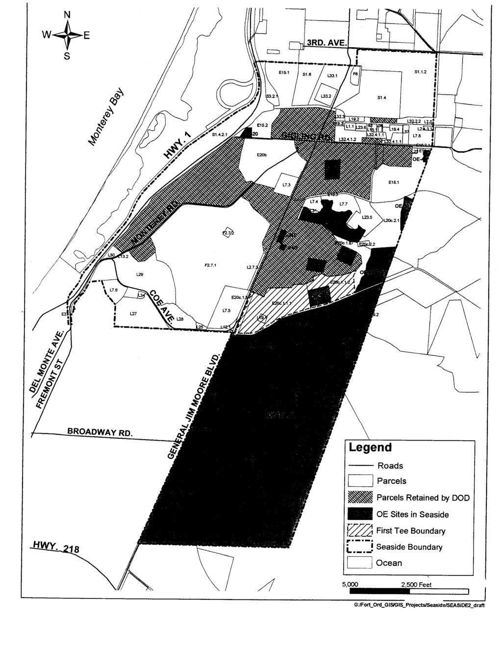
48
ATTACHMENT 4 CERCLA NOTICE, COVENANT, AND ACCESS PROVISIONS AND OTHER DEED PROVISIONS
 ATTACHMENT 4 CERCLA NOTICE, COVENANT, AND ACCESS PROVISIONS AND OTHER DEED PROVISIONS CERCLA NOTICE, COVENANT, AND ACCESS PROVISIONS AND OTHER DEED PROVISIONS The following CERCLA Notice, Covenant, and
GUIDANCE FOR LEAD-BASED PAINT HAZARD MANAGEMENT DURING TRANSFER OF ARMY REAL PROPERTY
 GUIDANCE FOR LEAD-BASED PAINT HAZARD MANAGEMENT DURING TRANSFER OF ARMY REAL PROPERTY DAIM-FDF-FE 30 March 2000 1. Purpose. The purpose of this guidance is to: a. Inform commanders of Army Major Commands
Technical Information Paper No
 Environmental Condition of Property (ECOP) Investigations Technical Information Paper No. 38-001-0312 PURPOSE. To provide information on ECOP investigations for Federal real property transactions and military
Riverbank AAP, CA. Conveyance Progress Report
 Riverbank AAP, CA Conveyance Progress Report As of 1 October 2017 Page 2 1 October 2017 BRAC 2005 TABLE OF CONTENTS Summary 2 Environmental Cleanup 3 Reuse Plan 4 Programmatic Agreement 4 Property Conveyance
QUIT CLAIM DEED OF CONVEYANCE
 BLANK SPACE FOR RECORDER OF DEEDS QUIT CLAIM DEED OF CONVEYANCE THIS QUIT CLAIM DEED OF CONVEYANCE is made and entered into by and between the United States of America, acting by and through the Deputy
1.1. Implements policy and assigns responsibility pursuant to Reference (a) for the disposal of real property.
 for the disposal of real property.") Department of Defense INSTRUCTION NUMBER 4165.72 December 21, 2007 Incorporating Change 2, August 31, 2018 USD(A&S) SUBJECT: Real Property Disposal References: (a) DoD Directive 4165.06, Real Property,
Department of Defense INSTRUCTION NUMBER 4165.72 December 21, 2007 Incorporating Change 2, August 31, 2018 USD(A&S) SUBJECT: Real Property Disposal References: (a) DoD Directive 4165.06, Real Property,
The University of Texas System Systemwide Policy. Policy: UTS Title. Environmental Review for Acquisition of Real Property. 2.
 1. Title 2. Policy Environmental Review for Acquisition of Real Property Sec. 1 Sec. 2 Policy Statement. It is the policy of The University of Texas System to minimize its potential for exposure to claims
EXHIBIT A ENVIRONMENTAL COVENANT AND ACCESS AGREEMENT
 ENVIRONMENTAL COVENANT AND ACCESS AGREEMENT AFTER RECORDING RETURN TO: Laura Wishik, Esq. Director, Environmental Protection Section P. O. Box 94769 Seattle, WA 98124-4769 GRANTOR AND OWNER: City of Seattle
IOWA SOLID WASTE PROGRAM ENVIRONMENTAL COVENANT
 IOWA SOLID WASTE PROGRAM ENVIRONMENTAL COVENANT This environmental covenant is established pursuant to Iowa Code (IC) chapter 455I entitled Uniform Environmental Covenants Act. {INSERT name(s) of fee title
MEMORANDUM OF AGREEMENT BETWEEN THE UNITED STATES DEPARTMENT OF THE ARMY AND THE JO-CARROLL DEPOT LOCAL REDEVELOPMENT AUTHORITY
 MEMORANDUM OF AGREEMENT BETWEEN THE UNITED STATES DEPARTMENT OF THE ARMY AND THE JO-CARROLL DEPOT LOCAL REDEVELOPMENT AUTHORITY FOR THE ECONOMIC DEVELOPMENT OF A PART OF THE FORMER MILITARY INSTALLATION
RESIDENTIAL ACCESS AGREEMENT. ( Owner ) and Butte-Silver Bow County ( BSB ) enter into this Residential Access Agreement ( Agreement ) this day of.
 and Butte-Silver Bow County ( BSB ) enter into this Residential Access Agreement ( Agreement ) this day of.") RESIDENTIAL ACCESS AGREEMENT ( Owner ) and Butte-Silver Bow County ( BSB ) enter into this Residential Access Agreement ( Agreement ) this day of. RECITALS A. BSB has received funding to conduct certain
RESIDENTIAL ACCESS AGREEMENT ( Owner ) and Butte-Silver Bow County ( BSB ) enter into this Residential Access Agreement ( Agreement ) this day of. RECITALS A. BSB has received funding to conduct certain
DECLARATION OF RESTRICTIVE COVENANTS. THIS DECLARATION OF RESTRICTIVE COVENANTS made this day of, 200_, by ( Declarant ). RECITALS
. RECITALS") DECLARATION OF RESTRICTIVE COVENANTS THIS DECLARATION OF RESTRICTIVE COVENANTS made this day of, 200_, by ( Declarant ). RECITALS WHEREAS, Declarant is the owner of the surface of certain real property
DECLARATION OF RESTRICTIVE COVENANTS THIS DECLARATION OF RESTRICTIVE COVENANTS made this day of, 200_, by ( Declarant ). RECITALS WHEREAS, Declarant is the owner of the surface of certain real property
DRAFT FINAL FINDING OF SUITABILITY TO TRANSFER (FOST) Little Patuxent River Parcel. October 16, 2013
 Little Patuxent River Parcel. October 16, 2013") DRAFT FINAL FINDING OF SUITABILITY TO TRANSFER (FOST) Little Patuxent River Parcel October 16, 2013 1. PURPOSE The purpose of this Finding of Suitability to Transfer (FOST) is to document the environmental
DRAFT FINAL FINDING OF SUITABILITY TO TRANSFER (FOST) Little Patuxent River Parcel October 16, 2013 1. PURPOSE The purpose of this Finding of Suitability to Transfer (FOST) is to document the environmental
THE REGULATIONS GOVERNING SOIL DISPLACEMENT AND DISPOSAL IN THE EAST HELENA SUPERFUND AREA IN LEWIS AND CLARK COUNTY, MONTANA.
 THE REGULATIONS GOVERNING SOIL DISPLACEMENT AND DISPOSAL IN THE EAST HELENA SUPERFUND AREA IN LEWIS AND CLARK COUNTY, MONTANA. 2013 Lewis & Clark City-County Health Department Lead Education and Abatement
EASEMENT AGREEMENT (Distributor Performance Non-Exclusive)
") EASEMENT AGREEMENT (Distributor Performance Non-Exclusive) THIS EASEMENT AGREEMENT, effective the day of, 20, is made between WITNESSETH:, hereafter called Grantor, (whether grammatically singular or plural)
EASEMENT AGREEMENT (Distributor Performance Non-Exclusive) THIS EASEMENT AGREEMENT, effective the day of, 20, is made between WITNESSETH:, hereafter called Grantor, (whether grammatically singular or plural)
Minnesota Pollution Control Agency Voluntary Investigation and Cleanup
 Minnesota Pollution Control Agency Voluntary Investigation and Cleanup Summary of Applicable Laws 1.0 Introduction Guidance Document #3 Over the past few years, the Minnesota Superfund law, known as the
BRAC 2005: Cleanup Privatization
 EPA s Federal Facilities Restoration and Reuse Office BRAC 2005: Cleanup Privatization Jim Woolford, Director Federal Facilities Restoration and Reuse Office March 22, 2006 Overview History: BRAC Rounds
Ohio EPA Guidance - VAP Environmental Covenants Updated July 2015
 Ohio EPA Guidance - VAP Environmental Covenants Updated July 2015 Drafting Proposed Environmental Covenants with Activity and Use Limitations for Properties Seeking Covenants Not to Sue OVERVIEW This guidance
ATTACHMENT 1 ENVIRONMENTAL PROTECTION PROVISIONS
 ATTACHMENT 1 ENVIRONMENTAL PROTECTION PROVISIONS ATTACHMENT 1 ENVIRONMENTAL PROTECTION PROVISIONS The following conditions, restrictions, and notification will be placed in the deed/easement to ensure
FACT SHEET Brownfields Cleanup Program (BCP) KEY DEFINITIONS (see also ECL )
 KEY DEFINITIONS (see also ECL )") KEY DEFINITIONS (see also ECL 27-1405) Brownfield A Brownfield is any real property where redevelopment or re-use may be complicated by the presence or potential presence of a hazardous waste, petroleum,
KEY DEFINITIONS (see also ECL 27-1405) Brownfield A Brownfield is any real property where redevelopment or re-use may be complicated by the presence or potential presence of a hazardous waste, petroleum,
Chapter XX Purchase of Development Rights Program
 Chapter XX Purchase of Development Rights Program Short Title. This ordinance is to be known and may be cited as the Purchase of Development Rights ( PDR ) Program. Purpose Pursuant to the authority granted
CITY OF VAUGHAN POLICY AND PROCEDURES FOR DEALING WITH CONTAMINATED OR POTENTIALLY CONTAMINATED SITES
 CITY OF VAUGHAN POLICY AND PROCEDURES FOR DEALING WITH CONTAMINATED OR POTENTIALLY CONTAMINATED SITES MAY 2001 This Report should be read in conjunction with the City of Vaughan BACKGROUND REPORT ON POLICY
DECLARATION OF RESTRICTIVE COVENANTS
 DECLARATION OF RESTRICTIVE COVENANTS The Declarant,, is the fee simple owner of the certain real property located in County, Kansas, as described on Exhibit A, which is attached hereto and incorporated
FORA Board Consistency Determinations Summary
 FORA Board Consistency Determinations Summary BOARD ACTION SUMMARIES Occurance (mm/dd/yy) Summary 1997 Approved Consistency of Marina Municipal Airport Redevelopment Plan: 2nd Finding of Consistency with
Chapter 100 Planned Unit Development in Corvallis Urban Fringe
 100.100 Scope and Purpose. Chapter 100 Planned Unit Development in Corvallis Urban Fringe (1) All applications for land divisions in the Urban Residential (UR) and Flood Plain Agriculture (FPA) zones within
Due Care Obligations
 Sec 324.XXXXX Due Care; duties of owner or operator, residential tenant, having knowledge of facility; compliance with section. (1) A current owner or operator of real property, or a residential tenant,
FINDING OF SUITABILITY TO TRANSFER (FOST) TWIN CITIES ARMY AMMUNITION PLANT RAMSEY COUNTY, MINNESOTA
 TWIN CITIES ARMY AMMUNITION PLANT RAMSEY COUNTY, MINNESOTA") FINDING OF SUITABILITY TO TRANSFER (FOST) TWIN CITIES ARMY AMMUNITION PLANT RAMSEY COUNTY, MINNESOTA February 2013 FINDING OF SUITABILITY TO TRANSFER (FOST) Twin Cities Army Ammunition Plant Arden Hills,
FINDING OF SUITABILITY TO TRANSFER (FOST) TWIN CITIES ARMY AMMUNITION PLANT RAMSEY COUNTY, MINNESOTA February 2013 FINDING OF SUITABILITY TO TRANSFER (FOST) Twin Cities Army Ammunition Plant Arden Hills,
PURCHASE AGREEMENT. 4. CONTINGENCIES. This Purchase Agreement is contingent upon the satisfaction of the following conditions:
 PURCHASE AGREEMENT 1. PARTIES. This purchase agreement (the Purchase Agreement ) is made this day of, 2017, by and between the County of Carver, Minnesota, a public body politic and corporate having the
Municipality of Anchorage PURCHASE AND SALE AGREEMENT FOR HLB Parcel C in Chugiak, Alaska
 Municipality of Anchorage PURCHASE AND SALE AGREEMENT FOR HLB Parcel 1-007-C in Chugiak, Alaska THIS AGREEMENT dated, 2017, by and between the MUNICIPALITY OF ANCHORAGE, an Alaska municipal corporation,
CHAPTER 14: DRIVEWAYS, TOWN HIGHWAYS, AND PRIVATE ROADS
 CHAPTER 14: DRIVEWAYS, TOWN HIGHWAYS, AND PRIVATE ROADS TABLE OF CONTENTS CHAPTER 14: PRIVATE DRIVEWAYS, TOWN HIGHWAYS AND PRIVATE ROADS 14-1 14.0100 AUTHORITY... 14-1 14.0200 TITLE... 14-1 14.0300 REGULATION
To achieve the conservation purposes, the following conditions and restrictions are set forth:
 DEED OF CONSERVATION EASEMENT (Conservation Subdivision District) STATE OF GEORGIA COUNTY OF COBB THIS DEED OF CONSERVATION EASEMENT (herein "Conservation Easement") is made this day of, 20, by and between
ADMINISTRATIVE GUIDANCE
 11 ADMINISTRATIVE GUIDANCE ON CONTAMINATED SITES Effective date: April 1, 2013 Version 1.1 May 2013 Expectations and Requirements for Contaminant Migration Introduction This guidance focusses on the ministry
Subpart A Disclosure of Known Lead-Based Paint and/or Lead-Based Paint Hazards Upon Sale or Lease of Residential
 35.80 35.910 Notices and pamphlet. 35.915 Calculating rehabilitation costs, except for the CILP program. 35.920 Calculating rehabilitation costs for the Flexible-Subsidy CILP Program. 35.925 Examples of
REGULATORY AGREEMENT Federal Credits
 Recording requested by and when recorded mail to: Tax Credit Allocation Committee 915 Capitol Mall, Room 485 P.O. Box 942809 Sacramento, CA 94209-0001 Free Recording Requested Space above this line In
Chapter SWAINSON S HAWK IMPACT MITIGATION FEES
 The Swainson s Hawk ordinance can also be viewed online at: http://qcode.us/codes/sacramentocounty/ Once at the website, click on Title 16 BUILDINGS AND CONSTRUCTION, then Chapter 16.130 SWAINSON S HAWK
May 2011 REDEVELOPMENT PLAN FOR THE CALIMESA REDEVELOPMENT PROJECT AREA NO. 2 CALIMESA REDEVELOPMENT AGENCY. Ordinance introduced on, 2011
 May 2011 REDEVELOPMENT PLAN FOR THE CALIMESA REDEVELOPMENT PROJECT AREA NO. 2 CALIMESA REDEVELOPMENT AGENCY Ordinance introduced on, 2011 Ordinance adopted on, 2011 Redevelopment Plan Prepared for the
Form SF298 Citation Data
 Form SF298 Citation Data Report Date ("DD MON YYYY") 17Jan2001 Report Type N/A Dates Covered (from... to) ("DD MON YYYY") Title and Subtitle Policy on Land Use Controls Associated with Environmental Restoration
FINDING OF SUITABILITY TO TRANSFER NAVAL RESERVE CENTER DULUTH, MINNESOTA
 FINDING OF SUITABILITY TO TRANSFER NAVAL RESERVE CENTER DULUTH, MINNESOTA Prepared by: Department of the Navy Base Realignment and Closure Program Management Office Northeast 4911 S. Broad Street Philadelphia,
Municipality of Anchorage PURCHASE AND SALE AGREEMENT FOR LOT 17, NEVILLA PARK SUBDIVISION
 Municipality of Anchorage PURCHASE AND SALE AGREEMENT FOR LOT 17, NEVILLA PARK SUBDIVISION THIS AGREEMENT dated, 2016, by and between the MUNICIPALITY OF ANCHORAGE, an Alaska municipal corporation, whose
Sabine River Authority, State of Louisiana
 Sabine River Authority, State of Louisiana Policy for Administering the Shoreline Management Plan (SMP) Encroachments Adopted by SRA Board of Commissioners: Introduction The Federal Energy Regulatory Commission
New Proposed Regulations Regarding Lead-based Paint Requirements
 New Proposed Regulations Regarding Lead-based Paint Requirements June 7, 1996 For CPD Newsbrief... June 1996 NEW PROPOSED REGULATIONS REGARDING LEAD-BASED PAINT REQUIREMENTS On June 7, 1996, HUD published
Ohio EPA Guidance - VAP Environmental Covenants May 2005 Updated February 2012
 Ohio EPA Guidance - VAP Environmental Covenants May 2005 Updated February 2012 Drafting Proposed Environmental Covenants with Activity and Use Limitations for Properties Seeking Covenants Not to Sue Overview
MN STATUTES ANNOTATED 145A.04 POWERS AND DUTIES OF BOARD OF HEALTH. Subdivision 1.Jurisdiction; enforcement. A county or multicounty board of health
 MN STATUTES ANNOTATED 145A.04 POWERS AND DUTIES OF BOARD OF HEALTH. Subdivision 1.Jurisdiction; enforcement. A county or multicounty board of health has the powers and duties of a board of health for all
MINNESOTA POLLUTION CONTROL AGENCY SITE REMEDIATION SECTION
 MINNESOTA POLLUTION CONTROL AGENCY SITE REMEDIATION SECTION DRAFT GUIDELINES GUIDANCE ON INCORPORATION OF PLANNED PROPERTY USE INTO SITE DECISIONS WORKING DRAFT, September 1998 (formerly August 25, 1997)
PURCHASE AGREEMENT ACCORDINGLY, FOR VALUABLE CONSIDERATION, RECEIPT OF WHICH IS HEREBY ACKNOWLEDGED, THE PARTIES AGREE AS FOLLOWS:
 PURCHASE AGREEMENT JOHN THOMAS BUILDING, 325 EAST 3 RD AVENUE, ANCHORAGE AK THIS AGREEMENT dated, 2013, by and between the MUNICIPALITY OF ANCHORAGE, an Alaska municipal corporation, whose mailing address
Public Sealed Bid Auction. State of Ohio Ohio University. Tract II and 919 East State Street Athens, Ohio 45701
 Public Sealed Bid Auction State of Ohio Ohio University Tract II 739-903 and 919 East State Street Athens, Ohio 45701 Bid Package Table of Contents: Notice of Sale by Sealed Bid Description of Property
BEACH STORM DAMAGE REDUCTION EASEMENT
 STATE OF FLORIDA COUNTY OF WALTON WALTON COUNTY, FL HURRICANE & STORM DAMAGE REDUCTION PROJECT FILE/REACH#: PARCEL ID#: BEACH STORM DAMAGE REDUCTION EASEMENT KNOW ALL MEN BY THESE PRESENTS, that for and
The Boeing Company On-Site Environment, Health and Safety Supplemental Provisions (SP4)
") THE CONTRACT WITH THE BOEING COMPANY is supplemented by the following additional clauses: 1.0 General. 1.1 In the event Seller or Seller s subcontractors or suppliers perform any On-Site Work, these additional
THE CONTRACT WITH THE BOEING COMPANY is supplemented by the following additional clauses: 1.0 General. 1.1 In the event Seller or Seller s subcontractors or suppliers perform any On-Site Work, these additional
PART 10. COMPLIANCE WITH SECTION 20107a OF ACT
 182 PART 10. COMPLIANCE WITH SECTION 20107a OF ACT R 299.51001 Definitions. Rule 1001. As used in this part: (a) "All appropriate inquiry" means the inquiry necessary to determine what response activity
TRANSBAY JOINT POWERS AUTHORITY
 STAFF REPORT FOR CALENDAR ITEM NO.: 15 FOR THE MEETING OF: March 10, 2011 TRANSBAY JOINT POWERS AUTHORITY BRIEF DESCRIPTION: Approving a Temporary Easement Agreement (Temporary Easement) between the Transbay
AGREEMENT TO ACQUIRE LANDS BETWEEN THE DEPARTMENT OF THE ARMY ST. PAUL DISTRICT, CORPS OF ENGINEERS AND. THE CITY OF City, State
 AGREEMENT TO ACQUIRE LANDS BETWEEN THE DEPARTMENT OF THE ARMY ST. PAUL DISTRICT, CORPS OF ENGINEERS AND THE CITY OF City, State FOR CONDEMNATION ON BEHALF OF THE SPONSOR BY THE CORPS OF ENGINEERS FOR THE
ARTICLE 5 GENERAL REQUIREMENTS
 5.1 SUITABILITY OF THE LAND ARTICLE 5 GENERAL REQUIREMENTS 5.1.1 Land subject to flooding, improper drainage or erosion, and land deemed to be unsuitable for development due to steep slope, unsuitable
UTILITY EASEMENT AGREEMENT
 THIS INSTRUMENT PREPARED BY AND RETURN TO: Roy K. Payne, Esq. Chief Assistant City Attorney 400 S. Orange Avenue Orlando, FL 32801 Roy.Payne@CityofOrlando.Net UTILITY EASEMENT AGREEMENT THIS UTILITY EASEMENT
THIS DECLARATION OF RESTRICTIVE COVENANTS is made this day of, 20, by ("Covenantor"). RECITALS
. RECITALS") Model for Use with Permits Without Mitigation Plans STATE OF COUNTY OF DECLARATION OF RESTRICTIVE COVENANTS THIS DECLARATION OF RESTRICTIVE COVENANTS is made this day of, 20, by ("Covenantor"). RECITALS
Model for Use with Permits Without Mitigation Plans STATE OF COUNTY OF DECLARATION OF RESTRICTIVE COVENANTS THIS DECLARATION OF RESTRICTIVE COVENANTS is made this day of, 20, by ("Covenantor"). RECITALS
HEALTH AND SAFETY CODE SECTION
 HEALTH AND SAFETY CODE SECTION 25400.10-25400.12 25400.10. (a) The Legislature finds and declares all of the following: (1) Methamphetamine use and production are growing throughout the state. Properties
EXHIBIT A AGREEMENT FOR SALE OF IMPROVEMENT TO REAL PROPERTY AND BILL OF SALE
 EXHIBIT A AGREEMENT FOR SALE OF IMPROVEMENT TO REAL PROPERTY AND BILL OF SALE This Agreement to buy and sell improvement to real property to be moved by Buyer and Bill of Sale is between Seller (also referred
GRANT OF TRAIL ACCESS EASEMENT, COVENANTS AND RESTRICTIONS
 This is a sample easement provided for discussion and illustrative purposes only. Easements for each property will be customized based upon the needs of each landowner and the Path. GRANT OF TRAIL ACCESS
LEASE-LEASEBACK SUBLEASE AGREEMENT. Dated as of April 1, Between. Newark Unified School District. and. Environmental Systems, Inc.
 LEASE-LEASEBACK SUBLEASE AGREEMENT Dated as of April 1, 2014 Between Newark Unified School District and Environmental Systems, Inc., Phase 1 District-Wide {SR134676.DOC} LEASE-LEASEBACK SUBLEASE AGREEMENT
ARTICLE III GENERAL PROCEDURES, MINOR PLANS AND FEE SCHEDULES
 ARTICLE III GENERAL PROCEDURES, MINOR PLANS AND FEE SCHEDULES 301. Prior to Submission a. Copies of this Ordinance shall be available on request, at cost, for the use of any person who desires information
CAMPBELL COUNTY AND CAMPBELL COUNTY SCHOOL DISTRICT NO. 1 GROUND LEASE
 CAMPBELL COUNTY AND CAMPBELL COUNTY SCHOOL DISTRICT NO. 1 GROUND LEASE THIS LEASE made and executed this day by and between Campbell County, 500 South Gillette Avenue, Gillette, WY 82716 (hereinafter referred
Tax-Exempt Bond Financed Project
 Recording requested by and when recorded mail to: Tax Credit Allocation Committee 915 Capitol Mall, Room 485 P.O. Box 942809 Sacramento, CA 94209-0001 Free Recording Requested In Accordance With Government
STANDARD CONDITIONS OF SALES FOR UNDERSIZED VACANT LOTS TO CONTIGUOUS PROPERTY OWNERS BIDDING PROCEDURE
 Schedule B STANDARD CONDITIONS OF SALES FOR UNDERSIZED VACANT LOTS TO CONTIGUOUS PROPERTY OWNERS BIDDING PROCEDURE 1. In order to bid on properties, each prospective purchaser must submit with his/her
ii. Minimum Property Requirements and Minimum Property Standards
 Underwriting the Property The Mortgagee must underwrite the completed appraisal report to determine if the Property provides sufficient collateral for the FHA-insured Mortgage. The appraisal and Property
U.S. Department of Housing and Urban Development Office of Public and Indian Housing
 1 U.S. Department of Housing and Urban Development Office of Public and Indian Housing Special Attention of: Notice PIH 2018-08 Regional and Field Office Directors of Public Housing Public Housing Agencies
Subpart Novation and Change-of- Name Agreements
 Subpart 42.12 Novation and Change-of- Name Agreements 42.1200 Scope of subpart. This subpart prescribes policies and procedures for (a) Recognition of a successor in interest to Government contracts when
DEPARTMENT OF THE ARMY U.S. Army Corps of Engineers Washington, DC Regulation No May 2015
 CEMP-CR DEPARTMENT OF THE ARMY U.S. Army Corps of Engineers Washington, DC 20314-1000 ER 405-1-19 Regulation No. 405-1-19 29 May 2015 Real Estate ACQUISITION BY CONDEMNATION PROCEEDINGS 1. Purpose. Engineer
ENVIRONMENTAL DISCLOSURE FOR TRANSFER OF REAL PROPERTY (IC ) State Form (R / 1-07) Indiana Department of Environmental Management
 State Form (R / 1-07) Indiana Department of Environmental Management") ENVIRONMENTAL DISCLOSURE FOR TRANSFER OF REAL PROPERTY (IC 13-25-3-7.5) State Form 52653 (R / 1-07) Indiana Department of Environmental Management A WARNING TO THE PARTIES TO A TRANSFER OF PROPERTY: The
ENVIRONMENTAL DISCLOSURE FOR TRANSFER OF REAL PROPERTY (IC 13-25-3-7.5) State Form 52653 (R / 1-07) Indiana Department of Environmental Management A WARNING TO THE PARTIES TO A TRANSFER OF PROPERTY: The
Terms and Conditions
 U.S. Department of Housing and Urban Development Terms and Conditions Constituting Part A of a Consolidated Annual Contributions Contract Between Housing Authority and the United States of America Forms
DEPARTMENT OF HUMAN SERVICES, PUBLIC HEALTH DIVISION
 DEPARTMENT OF HUMAN SERVICES, PUBLIC HEALTH DIVISION 333-040-0010 DIVISION 40 DECONTAMINATION OF ILLEGAL DRUG MANUFACTURING SITES Purpose and Scope (1) Purpose: The purpose of these rules is to implement
ROAD USE AGREEMENT RELATING TO THE DEVELOPMENT OF (WIND FARM NAME) WIND FARM
 WIND FARM") ROAD USE AGREEMENT RELATING TO THE DEVELOPMENT OF (WIND FARM NAME) WIND FARM THIS ROAD USE AGREEMENT (this Agreement ), dated this day of, 20, between the BOARD OF COUNTY SUPERVISORS OF UNION COUNTY, IOWA,
ROAD USE AGREEMENT RELATING TO THE DEVELOPMENT OF (WIND FARM NAME) WIND FARM THIS ROAD USE AGREEMENT (this Agreement ), dated this day of, 20, between the BOARD OF COUNTY SUPERVISORS OF UNION COUNTY, IOWA,
Planned Community Associations, Chapter 421J, Hawaii Revised Statutes
 336 VI Planned Community Associations, Chapter 421J, Hawaii Revised Statutes NOTES: 1. The following is the full text of the new Planned Community Associations Act, Act 132 (SLH 1997), which has been assigned
BROWNFIELDS Connecticut All Grantee Meeting July Getting the most out of All Appropriate Inquiries (AAI)
") BROWNFIELDS Connecticut All Grantee Meeting July 11 2012 Getting the most out of All Appropriate Inquiries (AAI) 1 AAI in Perspective All Appropriate Inquiries often is a critical step in a continuum of
BROWNFIELDS Connecticut All Grantee Meeting July 11 2012 Getting the most out of All Appropriate Inquiries (AAI) 1 AAI in Perspective All Appropriate Inquiries often is a critical step in a continuum of
July 1, 2017 HAZARDOUS SITE INVENTORY Environmental Protection Division Georgia Department of Natural Resources
 July 1, 2017 HAZARDOUS SITE INVENTORY Environmental Protection Division Georgia Department of Natural Resources HSI INTRO -i- July 1, 2017 INTRODUCTION TO THE HAZARDOUS SITE INVENTORY The purpose of this
VII Chapter 421J, Planned Community Associations
 399 VII Chapter 421J, Planned Community Associations 421J-1 Scope. This chapter shall apply to all planned community associations existing as of the effective date of this chapter and all planned community
AUCTION REAL ESTATE SALES CONTRACT
 STATE OF OHIO COUNTY OF OTTAWA BIDDER# AUCTION REAL ESTATE SALES CONTRACT THIS CONTRACT, made this the day of 2017, by and between CLEARWATER PRESERVE, LLC, ( Seller ) whose address is 1613 S DEFIANCE
2017 SPRING LAND SALE DISPOSAL TERMS AND CONDITIONS
 2017 SPRING LAND SALE DISPOSAL TERMS AND CONDITIONS Facilities and Land Management Facilities and Land Management 1815 Bragaw Street, Suite 101 2025 Yukon Drive, Suite 106 Anchorage, Alaska 99508-3438
Assignment, Assumption and Amendment of Lease
 This (this Agreement ) is made this day of, 2018, by and among Vigor Alaska - Seward LLC, an Alaska limited liability company ( Assignor ), JAG Alaska, Inc., an Alaska corporation ( Assignee ), and the
This document was prepared by: Albemarle County Attorney County of Albemarle 401 McIntire Road Charlottesville, Virginia 22902
 This document was prepared by: Albemarle County Attorney County of Albemarle 401 McIntire Road Charlottesville, Virginia 22902 Tax Map and Parcel Number This deed is exempt from taxation under Virginia
Residential Lease for Single Family Home or Duplex (FOR A TERM NOT TO EXCEED ONE YEAR)
") Residential Lease for Single Family Home or Duplex (FOR A TERM NOT TO EXCEED ONE YEAR) A BOX ( ) OR A BLANK SPACE ( ) INDICATES A PROVISION WHERE A CHOICE OR DECISION MUST BE MADE BY THE PARTIES. THE LEASE
Residential Lease for Single Family Home or Duplex (FOR A TERM NOT TO EXCEED ONE YEAR) A BOX ( ) OR A BLANK SPACE ( ) INDICATES A PROVISION WHERE A CHOICE OR DECISION MUST BE MADE BY THE PARTIES. THE LEASE
OAKLAND OVERSIGHT BOARD MEMORANDUM
 OAKLAND OVERSIGHT BOARD MEMORANDUM TO: Oakland Oversight Board FROM: Fred Blackwell SUBJECT: Approval of Oakland Army Base DATE: Disposition ITEM: # EXECUTIVE SUMMARY The Oakland Redevelopment Successor
The Lead-Based Paint Disclosure Manual. Your key to working with Federal HUD/EPA Disclosure Regulations
 The Lead-Based Paint Disclosure Manual Your key to working with Federal HUD/EPA Disclosure Regulations Published by the Illinois REALTORS 522 South Fifth Street Springfield, IL 62701 Copyright 2016, Illinois
Name Name Address Address. Telephone Telephone. Name Address. Telephone
 MAINE CONSUMER LAW GUIDE 16-3 1. PARTIES TO THIS LEASE The parties to the lease are: LANDLORD TENANT Name Name Address Address Telephone Telephone Name Address Telephone 2. MANAGING AGENT If the landlord
Speaker 10: Matthew Joy of Jorden Bischoff & Hiser PLC Page 1 TWO RECENT DEVELOPMENTS POTENTIALLY AFFECTING REAL ESTATE TRANSACTIONS
 Speaker 10: Matthew Joy of Jorden Bischoff & Hiser PLC Page 1 TWO RECENT DEVELOPMENTS POTENTIALLY AFFECTING REAL ESTATE TRANSACTIONS By: Matthew Joy Jorden Bischoff & Hiser, P.L.C. Phoenix, Arizona mjoy@jordenbischoff.com
ORDINANCE NO. 875 (AS AMENDED THROUGH 875
 ORDINANCE NO. 875 (AS AMENDED THROUGH 875.1) AN ORDINANCE OF THE COUNTY OF RIVERSIDE TO ESTABLISH A LOCAL DEVELOPMENT MITIGATION FEE FOR FUNDING THE PRESERVATION OF NATURAL ECOSYSTEMS IN ACCORDANCE WITH
ENVIRONMENTAL COVENANT
 OHIO E.P.A. Environmental Covenant AUG 19 ZOII Page 1 entered DIRECTOirs JOURNAL " official ENVIRONMENTAL COVENANT To be recorded with Deed Records - ORC 317.08 This Environmental Covenant is entered into
MONTEREY COUNTY SUPPLEMENTAL DISCLOSURE PROPERTY ADDRESS:
 MONTEREY COUNTY SUPPLEMENTAL DISCLOSURE PROPERTY ADDRESS: FUTURE DEVELOPMENT/REDEVELOPMENT Buyer is advised to investigate and satisfy himself/herself of future development in the surrounding area that
JURISDICTIONAL RUNOFF MANAGEMENT PROGRAM ENFORCEMENT RESPONSE PLAN
 CITY OF ESCONDIDO JURISDICTIONAL RUNOFF MANAGEMENT PROGRAM ENFORCEMENT RESPONSE PLAN June 2015 Utilities Department Environmental Programs Division 201 N. Broadway Escondido, CA 92025 760-839-4668 TABLE
LEASE DISPOSITION AND DEVELOPMENT AGREEMENT
 LEASE DISPOSITION AND DEVELOPMENT AGREEMENT This Lease Disposition and Development Agreement ( Agreement ) is entered into as of the Effective Date listed on the title page of this Agreement by and between
MINES AND MINERALS MANAGEMENT ACT 1995 CHAPTER I PRELIMINARY. 1. This Act shall be called the Mines and Minerals Management Act 1995.
 MINES AND MINERALS MANAGEMENT ACT 1995 CHAPTER I PRELIMINARY 1. This Act shall be called the Mines and Minerals Management Act 1995. 2. The Act shall come into force on the First Day of September 1995.
Chapter 5.75 RENTAL LICENSING AND INSPECTION
 RENTAL LICENSING AND INSPECTION Sections: 5.75.010 Statement of Purpose. 5.75.020 Definitions. 5.75.030 Applicability. 5.75.040 Rental License Requirement. 5.75.050 Rental Licenseing Standards. 5.75.060
PROPERTY LEASE AGREEMENT
 Attachment FAC-1 PROPERTY LEASE AGREEMENT THIS AGREEMENT ( Lease Agreement, Lease or Agreement ), is entered into as of the day of, 2013 by and between the MIDDLETOWN TOWNSHIP BOARD OF EDUCATION, a public
THE TOWN OF VAIL EMPLOYEE HOUSING GUIDELINES
 THE TOWN OF VAIL EMPLOYEE HOUSING GUIDELINES 10-19-99 10/19/99 Page 1 of 11 I. PURPOSE The purpose of the (Guidelines) is to set forth the occupancy requirements, re-sale procedures, and resale price limitations
Applicant means a person or entity who has filed an application for change of use of a manufactured home park.
 313-106.9 MANUFACTURED HOME PARK CONVERSION (Coastal) 106.9.1 Purpose. The purpose of the Manufactured Home Park Conversion procedure is to ensure that any conversion of manufactured home parks, which
ATTACHMENT A MEMORANDUM OF UNDERSTANDING. THIS MEMORANDUM OF UNDERSTANDING (this "Memorandum") is made and
 is made and") ATTACHMENT A MEMORANDUM OF UNDERSTANDING THIS MEMORANDUM OF UNDERSTANDING (this "Memorandum") is made and entered into and is effective as of this day of, 2013 (the Effective Date"), by and between the
ATTACHMENT A MEMORANDUM OF UNDERSTANDING THIS MEMORANDUM OF UNDERSTANDING (this "Memorandum") is made and entered into and is effective as of this day of, 2013 (the Effective Date"), by and between the
DRAFT PARK COUNTY US HIGHWAY 89 SOUTH EAST RIVER ROAD OLD YELLOWSTONE TRAIL ZONING DISTRICT REGULATIONS
 Formatting: Changes recommended by the Board and accepted by the County Commission are formatted in RED: Changes made by the Park County Commission are formatted in YELLOW highlight: and changes made by
Vesting of Roads and Reserves Policy
 Vesting of Roads and Reserves Policy Adopted by Full Council 28 July 2016 Table of Contents 1. Policy Statement and Purpose...... 1 2. Issue...... 1 3. Policy...... 2 Land Subject To Interests...... 2
GENERAL INSTRUMENT - PART 1 (This area for Land Title Office use) Page 1 of pages
 Page 1 of pages") LAND TITLE ACT FORM C (Section 233) Province of British Columbia GENERAL INSTRUMENT - PART 1 (This area for Land Title Office use) Page 1 of pages 1. APPLICATION: (Name, address, phone number and signature
LAND TITLE ACT FORM C (Section 233) Province of British Columbia GENERAL INSTRUMENT - PART 1 (This area for Land Title Office use) Page 1 of pages 1. APPLICATION: (Name, address, phone number and signature
APPENDIX 2. Chapter 8D. COOPERATIVES
 APPENDIX 2. Chapter 8D. COOPERATIVES ARTICLE 1. INTRODUCTORY PROVISIONS Section 46:8D-1 Cooperative Recording Act. 46:8D-2 Legislative findings and declaration. 46:8D-3 Definitions. 46:8D-4 County recording
This is a sample form for information ONLY. UTILITY INFRASTRUCTURE CONVEYANCE AND SERVICE AGREEMENT
 This is a sample form for information ONLY. A CSA will be tailored to your project at the appropriate time during the development process. Please contact the Development Services Team for additional information.
DEVELOPMENT SERVICES AGREEMENT
 DEVELOPMENT SERVICES AGREEMENT THIS DEVELOPMENT SERVICES AGREEMENT (the Agreement is made this day of, 2011 by and between, a nonprofit corporation, (the "Partnership;, a nonprofit corporation, as its