3/15/2016. City Council City Hall Wilmington, North Carolina Dear Mayor and Councilmembers:
|
|
|
- Bernice Eaton
- 5 years ago
- Views:
Transcription
 from R-15, Residential District to O&I-1 (CD) Office & Institutional-1 District (Conditional District) to construct a")
1 ITEM PH5 OFFICE OF THE CITY MANAGER (910) FAX(910) TDD (910) /15/2016 City Council City Hall Wilmington, North Carolina Dear Mayor and Councilmembers: Attached for your consideration is an ordinance for a conditional district rezoning (CD-8-216) from R-15, Residential District to O&I-1 (CD) Office & Institutional-1 District (Conditional District) to construct a 3,000 square-foot building which could allow the following uses: artist, commercial including silk screening; assembly hall; office, professional; office, medical; personal services; private recreation facility. The subject property is located at 6149 Wrightsville Avenue and contains a total of 1.18 acres. The subject site was part of the 1995 annexation, effective January 31, On July 1, 2015, Planning Commission recommended denial of a conditional district rezoning and special use permit to construct a 7,634 square-foot professional and medical office. Application for appeal was withdrawn prior to review by City Council. The requested conditional district rezoning would support the following City of Wilmington adopted focus area of Foster a Prosperous, Thriving Economy and Provide Sustainability and Adaptability. Staff recommends conditional approval of the requested rezoning. A community meeting was hosted by the applicant on January 20, The Planning Commission held a public hearing regarding this conditional district rezoning on February 3, The Planning Commission recommends denial of the rezoning. On February 10, 2016, a letter appealing the Planning Commission s recommendation of denial was submitted to the City Clerk. If approved, this ordinance would allow construction of a 3,000 square-foot building for various specified uses within the Wrightsville Avenue Corridor Overlay. If the request is not approved, the property would retain its current R-15, Residential District zoning designation and the project would not be permitted. Passage of the attached Ordinance is recommended. Respectfully submitted, Sterling B. Cheatham, City Manager PH5-1

2 Ordinance City Council City of Wilmington North Carolina Introduced By: Sterling B. Cheatham, City Manager Date: 3/15/2016 Ordinance Amending the Official Zoning Maps Of The City Adopted March 27, 1984 To Rezone Property Containing 1.18 Acres Located At 6149 Wrightsville Avenue From R-15, Residential District to O&I-1 (CD) Office & Institutional-1 District, Wrightsville Avenue Corridor Overlay (Conditional District) To Construct A 3,000 Square-Foot Building To Allow The Following Uses: Artist, Commercial Including Silk Screening; Assembly Hall; Office, Professional; Office, Medical; Personal Services; Private Recreation Facility(CD-8-216) LEGISLATIVE INTENT/PURPOSE: WHEREAS, NCGS Section 160A-385 authorizes local governments to change or modify zoning boundaries within their jurisdiction; and WHEREAS, the amendment set out below is made in accordance with NCGS Section 160A-364 and Article 3, Section of the Land Development Code. THEREFORE, BE IT ORDAINED: SECTION 1: The Official Zoning Maps of the City of Wilmington are hereby amended by removing the hereinafter described tract of land from the present R-15, Residential District and putting it in the O&I-1 (CD), Office & Institutional-1 (Conditional District) classification, said tract being more particularly described as follows: A certain tract or parcel of land lying and being in the City of Wilmington, New Hanover County, North Carolina and being the same tract of land shown as lot 1-R, Bradley Creek Landing on map book 55 page 109 in the New Hanover County Registry, and being more particularly described as follows: Beginning at an iron at the intersection of the western right of way of Rogersville Road (60 public right of way) and the southern right of way of Heron Run Drive (right of way varies), said iron also being the northeastern corner of lot 1, Heron Run (Map Book 29 Page 82), said corner also being the northern most corner of lot 1-R, Bradley Creek Landing (MB 55 PG 109): Proceed thence with the western right of way of Rogersville Road S W a distance of ft. to a point, thence continuing with said right of way S W a distance of ft. to a point, thence continuing with said right of way S W a distance of ft. to a point, thence continuing with said right of way S W a PH5-2
3 distance of ft. to a point at the intersection of the western right of way of Rogersville Road and the northern right of way line of Wrightsville Avenue (60 public right of way), thence with said northern right of way and with a curve turning to the left with a radius of ', with a chord bearing of S W and chord distance of ft. to a point, thence leaving said right of way and with the Bradley Creek marsh line N E a distance of ft. to a point, thence N E a distance of ft. to a point, thence N E a distance of ft. to a point, thence N E a distance of ft. to a point, thence N W a distance of ft. to a point, thence N W a distance of ft. to a point located at the southeastern corner of Lot 1,Heron Run (MB 29 PG 82), thence with said eastern property line N E a distance of ft. to the point of beginning and containing an area of 1.18 acres according to a survey and computations by Hanover Design Services, P.A. performed in May of SECTION 2: The following rules, regulations and conditions shall apply to the property described in this ordinance: 1. The use and development of the subject property shall comply with all regulations and requirements imposed by the Land Development Code, the City of Wilmington Technical Standards and Specifications Manual and any other applicable federal, state or local law, ordinance or regulation, as well as any condition stated below. In the event of a conflict, the more stringent requirement or higher standard shall apply. 2. Approval of this conditional district rezoning and special use permit request does not constitute technical approval of the site plan. Final approval by the Technical Review Committee and the issuance of all required permits must occur prior to release of the project for construction. 3. If, for any reason, any condition for approval is found to be illegal or invalid or if the applicant should fail to accept any condition following approval, the approval of the site plan for the district shall be null and void and of no effect and proceedings shall be instituted to rezone the property to its previous zoning classification. 4. The use and development of the subject property shall be in accordance with the plan as submitted on December 16, The proposed Office & Institutional-1 (Conditional District) shall be limited to the following uses. a. Uses permitted by-right i. artists, commercial, including silk screening ii. assembly hall iii. office, medical iv. office, professional v. personal services vi. private recreation facility 6. Any use allowing a drive-through is prohibited on site. 7. All existing protected trees not impacted by essential site improvements shall be preserved or mitigated. 8. Exterior site lighting shall be installed so as not to shine directly onto adjacent parcels. PH5-3
4 Site lighting shall be of standard height with a maximum of 12 feet. 9. A conceptual site lighting plan shall be submitted prior to construction release. 10. Any freestanding sign(s) on the site shall be monument style with landscaping around the base of the sign. 11. A 10-foot multi-use path shall be required along the Rogersville Road frontage. 12. A 5-foot sidewalk shall be required along the Wrightsville Avenue frontage 13. FEMA preliminary flood map information shall be added to the site plan review. 14. A pedestrian sidewalk shall be installed from both Wrightsville Avenue and Rogersville Road to the proposed building. 15. All city, state and federal regulations shall be followed. SECTION 3: The City Clerk and the Planning Director are hereby authorized and directed under the supervision of the City Manager to change the Zoning Maps on file in the office of the City Clerk and the Planning Division, to conform with this ordinance. SECTION 4: That any person violating the provisions of this ordinance, including the approved site plan, shall be subject to the penalties set forth in Section of the Land Development Code. SECTION 5: All ordinances or parts of ordinances in conflict with this ordinance are hereby repealed to the extent of such conflict. SECTION 6: If any section, subsection, paragraph, sentence, clause, phrase or portion of this ordinance is for any reason held invalid or unconstitutional by any court of competent jurisdiction, such portion shall be deemed severable and such holding shall not affect the validity of the remaining portions hereof. SECTION 7: This ordinance shall be effective immediately upon its adoption. Adopted at a meeting on 2016 Attest: Bill Saffo, Mayor Approved As To Form: Penelope Spicer-Sidbury, City Clerk City Attorney PH5-4

 Office & Institutional-1 District, Wrightsville Avenue Corridor Overlay (Conditional District) to construct a 3,000 square-foot building to allow the")
5 CASE SUMMARY Condition District Rezoning City Council March 15, 2016 CD Jeff Walton, , Staff recommendation CONDITIONAL APPROVAL Planning Commission recommendation 2/3/16; DENIAL, 7-0 City Council Action APPEALED ON 2/10/16; SCHEDULED FOR PUBLIC HEARING ON 3/15/16 Request Address Acreage Request 6149 Wrightsville Avenue Approximately 1.18 acres R-15, Residential District to O&I-1 (CD) Office & Institutional-1 District, Wrightsville Avenue Corridor Overlay (Conditional District) to construct a 3,000 square-foot building to allow the following uses: artist, commercial including silk screening; assembly hall; office, professional; office, medical; personal services; private recreation facility. Property Owner Falls Valley II, LLC jifinc1@att.net James Jackson (910) Old Military Road, Wilmington, NC Applicant Design Solutions cwolf@lobodemar.biz Cindee Wolf (910) P. O. Box 7221, Wilmington, NC Current land use and zoning Aerial Map Land Planning Data Applicable Plans/Policies CAMA Land Use City of Wilmington Adopted Focus Areas Future Land Use Plan Wrightsville Avenue 2030 Plan Conservation Area & Watershed Resource Protection PH5-5
6 Surrounding Area North South East West Zoning R-15 R-15 R-15 R-15 Current Land Use Single-family, vacant Single-family Single-family Marsh/Wetland Case Overview PROPOSAL and ANALYSIS The applicant proposes to rezone the subject site from R-15, Residential District to O&I- 1 (CD), Office and Institutional (Conditional District) for construction of a 3,000 squarefoot building. The proposed development is within the Wrightsville Avenue Corridor Overlay and shall be limited to the following uses. o Uses permitted by-right artists, commercial, including silk screening assembly hall office, medical office, professional personal services private recreation facility 22 parking spaces and 10 bicycle parking spaces will be provided behind the proposed building along Rogersville Road. 1. Zoning history The subject site was part of the 1995 annexation, effective January 31, On February 27, 2012, an application was submitted for conditional district rezoning, but was withdrawn prior to review by the Planning Commission. On July 1, 2015, Planning Commission recommended denial of a conditional district rezoning and special use permit to construct a 7,634 square-foot professional and medical office. Those speaking in opposition at the public hearing expressed concerns with traffic congestion, negative impact on surrounding property values, and light pollution. On July 8, 2015, a letter appealing the Planning Commission s recommendation of denial was submitted to the City Clerk. On August 4, 2015, an application for appeal was submitted for conditional district rezoning and a special use permit, but was withdrawn prior to review by City Council. 2. Zoning District Purpose Statements R-15, Residential District This district is established for low density residential development and other compatible uses. Recognition of the existing residential development pattern located within the city and on its fringes creates a need for this district to preserve the character of these established neighborhoods and protect their associated property values. Land uses considered harmful to the health, safety and welfare of district residents shall be prohibited from infringing upon the livability of the residential areas within the district. O&I-1, Office and Institutional-1 District This district is established to provide areas that are conducive to the establishment and operation of institutional, office and limited commercial activities not involving the sale of merchandise. Standards are designed so that these districts, in some instances, may serve as transitions between residential PH5-6
7 districts and other commercial districts. The principal means of ingress and egress for uses in the districts shall be along collector roads, minor arterials, and/or major arterials as designated on the city's Thoroughfare Plans. Proposed Driveway Access 3. Impacts on Public services, Facilities, and Infrastructure 3.1 Traffic Access will be from a single driveway location off Rogersville Road. A 5-foot sidewalk is proposed along Wrightsville Avenue. According to the Wilmington New Hanover County Comprehensive Greenway Plan, a 10-foot multi-use path would be required along the Rogersville Road frontage. Wrightsville Avenue is defined as a collector street, and Rogersville Road is defined as a local street. PH5-7
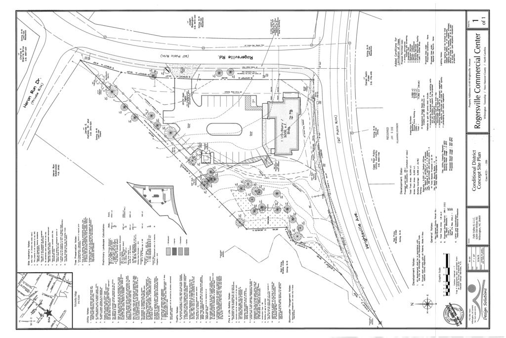
8 Table Estimated Trip Generation Zoning Land Use Intensity Existing R-15 AM Peak Hour Trips PM Peak Hour Trips Average Weekday 2- way Volume Trips (ADT) Single Family 3 lots Proposed Office, Medical 3,000 O&I-1 (CD) Use square feet Proposed Office, 3,000 O&I-1 (CD) Professional Use square feet Source: Institute of Transportation Engineers Trip Generation, 9th Edition, TRIP GENERATION BY Trafficware TripGen Table Current Volumes, Capacities and Levels of Service Road Location Volume Capacity V/C LOS Wrightsville Avenue At Rogersville Road 10,131 15, D Rogersville Road At Wrightsville Avenue 4,003 9, B 3.2 Parking Requirements Table Parking Schedule Required Proposed Minimum/Maximum Spaces 12/18 22 spaces Required Bicycle Parking Spaces Required 5 10 spaces 3.3 Public Utilities CFPUA has adequate capacity for water and sewer connections at this location. Table Cape Fear Public Utilities (CFPUA) Type Ownership Size Location Water Main (Existing) CFPUA 8-inch Rogersville Road Sewer Main (Existing) CFPUA 10-inch Rogersville Road 3.4 Stormwater The project would create 17,356 (33.6%) square feet of newly constructed builtupon area. Designs for on-site stormwater management would be reviewed for compliance with the city s stormwater management regulations. 3.5 Environmental Design Since the site is located within the Conservation Area & Watershed Resource Protection of the CAMA Land Use Classification Map, impervious surface cannot exceed 25 percent of the total site acreage unless the project is exceptionally designed. The applicant proposes the following to comply with exceptional design: o Incorporating amended soils if the existing soils are not suitable to support the proposed pervious pavement. o Disconnecting roof drains from the stormwater piping network PH5-8
9 o o Directing sidewalk runoff to adjacent vegetation to capture, infiltrate and treat for water quality. Landscaping with native vegetation. 3.6 FEMA Flood Area A portion of the property is shown within a Special Flood Hazard Area (SFHA) on Effective NC Flood Map J at Base Flood Elevation 10 feet. However, a Federal Emergency Management Agency (FEMA) map revision based on fill was approved in 2006 removing that determination. The 2015 FEMA preliminary flood maps enlarge the floodplain area and increase the Base Flood Elevation to 12 feet. The applicant would be required to provide documentation from one of the following: o An elevation certificate showing that the lowest finished floor is at Base Flood Elevation (BFE) plus 2 feet, o o Obtain an updated Letter of Map Revision (LOMR), Provide a survey showing the proposed building is outside the floodplain or flood-proof the proposed structure. Staff recommends that the preliminary flood map information be added to the site plan during TRC review. 3.7 Wrightsville Avenue Corridor Overlay Regulations (WACO) Compliance The subject property fronts Wrightsville Avenue, and if developed as proposed, must comply with the WACO regulations found in Section of the Land Development Code. New nonresidential or multifamily construction in the Wrightsville Avenue Corridor is to be compatible with that of existing buildings in the block in which they are located, including building setbacks, building height and building orientation to the street. o The project proposal is for a 3,000 square-foot building and is not subject o to a special use permit. The total lot coverage is approximately 3,000 square feet or 6.9% of the total lot area, which is less than the 25% maximum lot coverage permitted for properties located in the WACO. Lot coverage is defined as the portion of the lot covered by buildings and does not include other impervious surfaces. All new nonresidential structures in the Wrightsville Avenue Corridor Overlay must be setback a minimum of 20 feet from the Wrightsville Avenue street rightof-way. o The proposed office building have a front setback of 20 feet from Wrightsville Avenue and 20 feet from Rogersville Road. The orientation of all new nonresidential structures in the Wrightsville Avenue Corridor Overlay must follow the dominant orientation of structures along the block face in which the structure is located. o o Although the entrance to the proposed building will be oriented to face the interior of the site, the façade of the building located along Wrightsville Avenue will be designed in a manner to give the appearance of facing Wrightsville Avenue. Staff recommends that a pedestrian sidewalk be installed from both Wrightsville Avenue and Rogersville Road to the proposed building. PH5-9
10 The exterior building materials for all new nonresidential structures in the Wrightsville Avenue Corridor Overlay are limited to wood frame, stucco, brick, shingles, vinyl, masonite or aluminum siding designed to resemble wooden lap siding or shingles or a combination of the listed materials. o The sides of the buildings that front Wrightsville Avenue are proposed to contain windows along the entire frontage, meeting the WACO requirements. The buildings will be constructed of material that complies with the list of materials permitted in the WACO. 3.8 Other Reviews TRC Concept plan review occurred on May 28, 2015; a full TRC review would be required. 4. CONSISTENCY WITH ADOPTED PLANS 4.1 City of Wilmington Strategic plan o Foster a Prosperous, Thriving Economy The City will promote opportunity and prosperity by fostering sustainable, regionally coordinated economic growth and development strategies for creating jobs, building a strong workforce, facilitating commerce and business vitality. o Provide Sustainability and Adaptability The City will protect and preserve our natural resources with quality design for the built environment. The City will make strategic decisions focused on the long-term financial, physical and social health of the entire City to enhance our ability to respond to changing economic and demographic conditions. Our actions will be based on a shared commitment to inclusiveness, equity and continuous improvement. Applicability: The proposal would promote economic development by creating and sustaining jobs. The proposal would preserve and protect the environment by incorporating exceptional design elements and setting aside open space and natural areas through the development. Mixed use neighborhoods are a more sustainable, long term development pattern then large contiguous residential areas, that tend to increase auto dependency Wilmington Future Land Use Plan (FLUP) o Chapter II Infill Development of Vacant Land Objective 3.1: Infill sites may be developed as zoned or considered for rezoning to new uses that will enhance the functionality and promote the economic vitality of the surrounding area. Strategy 3.1.4: Develop and utilize zoning districts that allow smaller neighborhood-scale businesses and that incorporate site and building design regulations to ensure that infill development will retain aesthetic as well as functional compatibility with surrounding development. Applicability: The subject site is not identified as a infill small-tract area, however, the applicant proposes a use and site plan specific conditional district rezoning application. The proposed site plan provides benefits to PH5-10
11 the area for infill and sound environmental practice through the exceptional design elements. 4.3 Wrightsville Avenue 2030 (WA2030) o Chapter 3.1 Land Use Objective: Maintain a mix of compatible uses and preserve the residential character of the corridor. Strategy 3.1.1: Support development/redevelopment in accordance with the Recommended Land Use Map. o Encourage neighborhood scale commercial use or multifamily uses. Support only conditional district rezoning requests to NB, O&I-1 or MF-L. Applicability: o The applicant has met the context of the WA2030 through a conditional district application and a use specific site plan. o The property fronts of both Rogersville Road and Wrightsville Avenue. Staff recognizes that it is unlikely the site would develop as single family residential due to the narrow lot as well as the traffic, light and noise pollution from the adjacent roadways. o The proposed rezoning to specific uses would comply with the plan-supported neighborhood scale commercial use. o The recommended land use map for property located at the Wrightsville Avenue and Rogersville Road intersection encourages neighborhood scale commercial use or multifamily uses. CONCLUSIONS 1) The site is currently zoned R-15, Residential District. 2) The proposed rezoning is consistent with the recommended land use map of the Wrightsville Avenue 2030 plan. 3) The proposal is consistent with the Wrightsville Avenue Corridor Overlay regulations that require the development to be consistent with the surrounding uses, building scale, and streetscape. 4) Wrightsville Avenue and Rogersville Road have sufficient capacity to accommodate the estimated increase in traffic associated with the proposed zoning classification. RECOMMENDATION Based on the findings of fact and the information contained in this case summary, the City of Wilmington Adopted Focus Areas, Wrightsville Avenue 2030 plan, and Wilmington Future Land Use Plan, staff believes the request is reasonable and in the public interest. Staff recommends conditional approval of the conditional district rezoning and special use permit request subject to the following conditions: 1. The use and development of the subject property shall comply with all regulations and requirements imposed by the Land Development Code, the City of Wilmington Technical PH5-11
12 Standards and Specifications Manual and any other applicable federal, state or local law, ordinance or regulation, as well as any condition stated below. In the event of a conflict, the more stringent requirement or higher standard shall apply. 2. Approval of this conditional district rezoning and special use permit request does not constitute technical approval of the site plan. Final approval by the Technical Review Committee and the issuance of all required permits must occur prior to release of the project for construction. 3. If, for any reason, any condition for approval is found to be illegal or invalid or if the applicant should fail to accept any condition following approval, the approval of the site plan for the district shall be null and void and of no effect and proceedings shall be instituted to rezone the property to its previous zoning classification. 4. The use and development of the subject property shall be in accordance with the plan as submitted on December 16, The proposed Office & Institutional-1 (Conditional District) shall be limited to the following uses. a. Uses permitted by-right i. artists, commercial, including silk screening ii. assembly hall iii. office, medical iv. office, professional v. personal services vi. private recreation facility 6. Any use allowing a drive-through is prohibited on site. 7. All existing protected trees not impacted by essential site improvements shall be preserved or mitigated. 8. Exterior site lighting shall be installed so as not to shine directly onto adjacent parcels. Site lighting shall be of standard height with a maximum of 12 feet. 9. A conceptual site lighting plan shall be submitted prior to construction release. 10. Any freestanding sign(s) on the site shall be monument style with landscaping around the base of the sign. 11. A 10-foot multi-use path shall be required along the Rogersville Road frontage. 12. A 5-foot sidewalk shall be required along the Wrightsville Avenue frontage 13. FEMA preliminary flood map information shall be added to the site plan review. 14. A pedestrian sidewalk shall be installed from both Wrightsville Avenue and Rogersville Road to the proposed building. 15. All city, state and federal regulations shall be followed. NEIGHBORHOOD CONTACT Planning Commission City Council Signs Posted 1/19/16 3/1/16 Property Owner Letters 1/19/16 3/1/16 Advertisement Date(s) 1/29/16 3/4/16 & 3/11/16 Other Contact(s) Mark Harris, Laura McCabe, Charlotte Buckley, Doug Sherwood Doug Sherwood, Charlotte Buckley Community Meeting: 1/20/16 PH5-12
13 ACTIONS TO DATE Planning Commission 2/3/16; DENIAL, 7-0 City Council Action APPEALED ON 2/10/16; SCHEDULED FOR PUBLIC HEARING ON 3/15/16 Information from the 2/3/16 Planning Commission meeting: Several residents spoke in opposition to the request. Topics of the discussion included stormwater runoff, tree preservation, vegetative buffers, light, noise, and traffic congestion. After discussion, the Planning Commission recommended denial of the request. On February 10, 2016, a letter appealing the Planning Commission s recommendation of denial was submitted to the City Clerk. ATTACHMENTS 1. Conditional District Rezoning application (Dated 12/16/15) 2. Location and Zoning Map (Dated 1/12/16) 3. Aerial Map (Dated 1/12/16) 4. Wrightsville Avenue 2030 Plan (Adopted 1/12/16) 5. Exceptional Design Narrative (Dated 12/16/15) 6. Community Meeting Report (Dated 1/21/16) 7. Proposed Building Elevations (Dated 12/16/15) 8. Proposed Site plan (Dated 1/5/16) 9. Applicant s Appeal Letter (Dated 2/10/16) 10. Planning Commission consistency statement (Dated 2/3/16) 11. Draft Planning Commission 2/3/16 meeting minutes 12. Ordinance PH5-13
14 Transmittal February 10, 2016 To: Ms. Penny Spicer-Sidbury Wilmington City Clerk From: Cindee Wolf Re: Case No. CD / 6149 Wrightsville Avenue As authorized agent on behalf of the property owner of the referenced case, I am notifying you of our wish to appeal the February 3, 2016 Planning Commission s recommendation for denial to the City Council for review at their March 15, 2016 public hearing. Please do not hesitate to contact me if you have any questions or need additional information. Thank you. cc: James Jackson - Owner Jeff Walton Associate Planner P.O. Box 7221, Wilmington, NC * Telephone: * cwolf@lobodemar.biz PH5-14
15 PH5-15
16 PH5-16
17 PH5-17

18 Attachment 1 - Application PH5-18
19 PH5-19
20 PH5-20

21 CD Wrightsville Avenue Attachment 2 Land Use & Zoning Site Single Family Multi Family Vacant Utilities City of Wilmington PH5-21 1/12/16

22 CD Wrightsville Avenue Attachment 3 Aerial Site City of Wilmington PH5-22 1/12/16

23 CD Wrightsville Avenue Attachment 4 WA2030 Recommendations Site Retain Single-family Zoning or Use Retain Multi-family Uses Zoning Change Recommended City of Wilmington PH5-23 1/12/16
24 PH5-24
25 PH5-25
26 Attachment 6 - Community Report PH5-26
27 Attachment 6 - Community Report PH5-27
28 Attachment 6 - Community Report PH5-28

29 Attachment 7 - Elevations PH5-29
30 PH5-30
31 PH5-31
32 PH5-32
The requested rezoning would be consistent with the City of Wilmington Focus Area of Welcoming Neighborhoods and Public Spaces.
 ITEM PH3 OFFICE OF THE CITY MANAGER (910) 341-7810 FAX(910)341-5839 TDD (910)341-7873 1/6/2015 City Council City Hall Wilmington, North Carolina 28401 Dear Mayor and Councilmembers: Attached for your consideration
The requested rezoning would be consistent with the City of Wilmington Focus Area of Foster a Prosperous, Thriving Economy.
 ITEM PH2 OFFICE OF THE CITY MANAGER (910) 341-7810 FAX(910)341-5839 TDD (910)341-7873 9/1/2015 City Council City Hall Wilmington, North Carolina 28401 Dear Mayor and Councilmembers: Attached for your consideration
2/16/2016. City Council City Hall Wilmington, North Carolina Dear Mayor and Councilmembers:
 ITEM O1 2/16/2016 OFFICE OF THE CITY MANAGER (910) 341-7810 FAX(910)341-5839 TDD (910)341-7873 City Council City Hall Wilmington, North Carolina 28401 Dear Mayor and Councilmembers: Attached for your consideration
PLANNING COMMISSION. Agenda Item # 4.
 PLANNING COMMISSION Agenda Item # 4. CASE SUMMARY Special Use Permit Planning Commission December 5, 2012 SU-1-1212 Jeff Walton, 910-341-3260, jeff.walton@wilmingtonnc.gov Staff recommendation CONDITIONAL
Attached for your consideration is an ordinance amending the official zoning maps of the City of Wilmington.
 ITEM PH1 OFFICE OF THE CITY MANAGER (910) 341-7810 FAX(910)341-5839 TDD (910)341-7873 7/9/2013 City Council City Hall Wilmington, North Carolina 28401 Dear Mayor and Councilmembers: Attached for your consideration
4/3/2018. City Council City Hall Wilmington, North Carolina Dear Mayor and Councilmembers:
 ITEM PH2 OFFICE OF THE CITY MANAGER (910) 341-7810 FAX (910)341-5839 TDD (910)341-7873 4/3/2018 City Council City Hall Wilmington, North Carolina 28401 Dear Mayor and Councilmembers: Attached for your
CASE SUMMARY Conditional District Zoning Modification Planning Commission January 9, 2013 CD M1212
 CASE SUMMARY Conditional District Zoning Modification Planning Commission January 9, 2013 CD-3-109-M1212 Jim Diepenbrock, Associate Planner jim.diepenbrock@wilmingtonnc.gov 910-341-3257 Staff recommendation
ACTION FORM BRYAN CITY COUNCIL
 ACTION FORM BRYAN CITY COUNCIL DATE OF COUNCIL MEETING: July 8, 2014 DATE SUBMITTED: June 17, 2014 DEPARTMENT OF ORIGIN: Development Services SUBMITTED BY: Maggie Dalton MEETING TYPE: CLASSIFICATION: ORDINANCE:
Town of Holly Springs Town Council Meeting Agenda Cover Sheet
 Town of Holly Springs Town Council Meeting Agenda Cover Sheet Meeting Date: Feb. 19, 2019 Agenda Item #: 8c Agenda Placement: Public Hearing (Recognitions (awards, proclamations), Requests & Communications
CITY OF TYLER CITY COUNCIL COMMUNICATION
 CITY OF TYLER CITY COUNCIL COMMUNICATION Agenda Number: Z-2 Date: January 23, 2019 Subject: PD18-035 FAIR NANCY WOOD (2801 AND 2835 SOUTH BROADWAY AVENUE) Request that the City Council consider approving
STAFF SUMMARY FOR Z18-09 CONDITIONAL ZONING DISTRICT APPLICATION
 STAFF SUMMARY FOR Z18-09 CONDITIONAL ZONING DISTRICT APPLICATION APPLICATION SUMMARY Case Number: Z18-09 Request: Conditional R-10 Zoning District in order to develop a performance residential development
LOCATION MAP: AERIAL PHOTOGRAPH, 2015:
 LOCATION MAP: AERIAL PHOTOGRAPH, 2015: ORDINANCE NO. AN ORDINANCE OF THE CITY OF BRYAN, TEXAS, AMENDING CHAPTER 130, ZONING, OF THE CITY OF BRYAN CODE OF ORDINANCES, BY CHANGING THE ZONING CLASSIFICATION
Planning Department Oconee County, Georgia
 Planning Department Oconee County, Georgia STAFF REPORT REZONE CASE #: 6985 DATE: October 31, 2016 STAFF REPORT BY: Andrew C. Stern, Planner APPLICANT NAME: Williams & Associates, Land Planners PC PROPERTY
STAFF SUMMARY OF Z17-10 CONDITIONAL ZONING DISTRICT APPLICATION
 STAFF SUMMARY OF Z17-10 CONDITIONAL ZONING DISTRICT APPLICATION APPLICATION SUMMARY Case Number: Z17-10 Request: Conditional B-2 Zoning District in order to expand an existing retail and warehousing business
Conditional Use Permit case no. CU 14-06: Bristol Village Partners, LLC
 PLANNING AND ZONING COMMISSION STAFF REPORT August 7, 2014 Conditional Use Permit case no. CU 14-06: Bristol Village Partners, LLC CASE DESCRIPTION: LOCATION: LEGAL DESCRIPTION: EXISTING LAND USE: ZONING:
Town of Cary, North Carolina Rezoning Staff Report 12-REZ-27 Morris Branch Town Council Public Hearing January 24, 2013
 Town of Cary, North Carolina Rezoning Staff Report 12-REZ-27 Morris Branch Town Council Public Hearing January 24, 2013 REQUEST To amend the Town of Cary Official Zoning Map to rezone approximately 9.0
PLANNING COMMISSION. Agenda Item # 2.
 PLANNING COMMISSION Agenda Item # 2. LAND DEVELOPMENT CODE AMENDMENT Planning Commission: March 1, 2017 Case: LDC-13-317 Staff Contact: Brian Chambers; brian.chambers@wilmingtonnc.gov; 910-341-5885 Staff
Town of Cary, North Carolina Rezoning Staff Report 14-REZ-31 Cary Park PDD Amendment (Waterford II) Town Council Meeting January 15, 2015
 Town Council Meeting January 15, 2015") Town of Cary, North Carolina Rezoning Staff Report 14-REZ-31 Cary Park PDD Amendment (Waterford II) Town Council Meeting January 15, 2015 REQUEST To amend the Town of Cary Official Zoning Map by amending
Town of Cary, North Carolina Rezoning Staff Report 14-REZ-31 Cary Park PDD Amendment (Waterford II) Town Council Meeting January 15, 2015 REQUEST To amend the Town of Cary Official Zoning Map by amending
Proposed Zoning, Use(s), & Narrative
, & Narrative") Proposed Zoning, Use(s), & Narrative Proposed Conditional Zoning District: CZD B-2 Total Acreage of Proposed District: 3.45 AC. Only uses allowed by right in the corresponding General Use District are
Proposed Zoning, Use(s), & Narrative Proposed Conditional Zoning District: CZD B-2 Total Acreage of Proposed District: 3.45 AC. Only uses allowed by right in the corresponding General Use District are
Town of Cary, North Carolina Rezoning Staff Report 14-REZ-20 Habitat for Humanity Evans Road Town Council Meeting October 16, 2014
 Town of Cary, North Carolina Rezoning Staff Report 14-REZ-20 Habitat for Humanity Evans Road Town Council Meeting October 16, 2014 REQUEST To amend the Town of Cary Official Zoning Map by rezoning 0.53
ORDINANCE NO. NOW, THEREFORE, BE IT ORDAINED BY THE CITY COUNCIL OF THE CITY OF BRYAN, TEXAS:
 LOCATION MAPS: ORDINANCE NO. AN ORDINANCE OF THE CITY OF BRYAN, TEXAS, AMENDING CHAPTER 130, ZONING, OF THE CITY OF BRYAN CODE OF ORDINANCES, BY CHANGING THE ZONING CLASSIFICATION FROM AGRICULTURAL - OPEN
STAFF REPORT FOR Z19-01 CONDITIONAL ZONING DISTRICT APPLICATION
 STAFF REPORT FOR Z19-01 CONDITIONAL ZONING DISTRICT APPLICATION APPLICATION SUMMARY Case Number: Z19-01 Request: To rezone the southern 2 acres of the subject property along Piner Road to (CZD) B-1 in
CITY OF OCALA CITY COUNCIL REPORT Council Meeting Date: 06/06/17
 CITY OF OCALA CITY COUNCIL REPORT Council Meeting Date: 06/06/17 Subject: Large Scale Land Use Map Amendment Submitted By: David Boston Department: Growth Management STAFF RECOMMENDATION (Motion Ready):
4/18/2017. City Council City Hall Wilmington, North Carolina Dear Mayor and Councilmembers:
 ITEM R1 OFFICE OF THE CITY MANAGER (910) 341-7810 FAX (910)341-5839 TDD (910)341-7873 4/18/2017 City Council City Hall Wilmington, North Carolina 28401 Dear Mayor and Councilmembers: Attached for your
PLANNING COMMISSION. Agenda Item # 1.
 PLANNING COMMISSION Agenda Item # 1. CASE SUMMARY Street Closure Planning Commission October 7, 2015 SC-1-1015 Jeff Walton, 341-3260, jeff.walton@wilmingtonnc.gov Staff recommendation APPROVAL Planning
PLANNING COMMISSION. Agenda Item # 8.
 PLANNING COMMISSION Agenda Item # 8. CASE SUMMARY Street Closure Planning Commission February 1, 2016 SC-1-217 Jeff Walton, 341-3260, jeff.walton@wilmingtonnc.gov Staff recommendation APPROVAL Planning
AGENDA ITEM SUMMARY GLADES COUNTY BOARD OF COUNTY COMMISSIONERS
 AGENDA ITEM SUMMARY GLADES COUNTY BOARD OF COUNTY COMMISSIONERS SUBJECT: Case Number COMP17-02, RFYC, LLC This is a Legislative Hearing. DEPARTMENT REQUEST: The Community Development Department requests
ARTICLE 3 ZONING DISTRICTS AND ZONING MAP. Table of Contents
 ARTICLE 3 ZONING DISTRICTS AND ZONING MAP Table of Contents 3-1 Establishment of Zoning Districts... 1 A. General Use Zoning Districts... 1 B. Conditional Zoning Districts... 3 C. Overlay Zoning Districts...
BY THE CITY COMMISSION ORDINANCE NO.:
 BY THE CITY COMMISSION ORDINANCE NO.: 2005-0868 AN ORDINANCE BY THE CITY COMMISSION OF THE CITY OF DADE CITY, FLORIDA CREATING A DEVELOPMENT REVIEW PROCEDURES ORDINANCE; PROVIDING FOR INTENT, PURPOSE,
ORDINANCE WHEREAS, the Planning and Zoning Board of the City of Belleview has been designated as the Local Planning Agency; and
 Page 1 of 9 ORDINANCE 2019-03 AN ORDINANCE OF THE CITY OF BELLEVIEW, FLORIDA RELATING TO AN AMENDMENT OF 8.87 +/- ACRES OF LAND TO THE CITY OF BELLEVIEW COMPREHENSIVE PLAN; AMENDING THE FUTURE LAND USE
October 8, Section 402 Appendix A, "Land Management Code" The Code of the City of Frederick, 1966 (as amended)
") PLANNING COMMISSION THE CITY OF FREDERICK MAYOR AND BOARD OF ALDERMEN ORDINANCE NO: G-18-27 LEGISLATIVE HISTORY PUBLIC HEARING: September 11, 2018 October 8, 2018 RECOMMENDATION SUBMITTED TO MAYOR & BOARD:
PLANNING COMMISSION THE CITY OF FREDERICK MAYOR AND BOARD OF ALDERMEN ORDINANCE NO: G-18-27 LEGISLATIVE HISTORY PUBLIC HEARING: September 11, 2018 October 8, 2018 RECOMMENDATION SUBMITTED TO MAYOR & BOARD:
31, Township 29 South, Range 25 East, Polk County, Florida, as depicted by the Land Use Plan attached
 ORDINANCE NO. 2013-04 AN ORDINANCE AMENDING THE ZONING MAP OF THE CITY OF BARTOW, FLORIDA, REZONING APPROXIMATELY 2. 2 ACRES OF LAND OWNED BY BALA3I OF POLK COUNTY, LLC AND LOCATED IN SECTION 31, TOWNSHIP
Town of Cary, North Carolina Rezoning Staff Report 14-REZ-24 Indian Wells Road Properties Town Council Meeting November 20, 2014
 Town of Cary, North Carolina Rezoning Staff Report 14-REZ-24 Indian Wells Road Properties Town Council Meeting November 20, 2014 REQUEST To amend the Town of Cary Official Zoning Map by revising a condition
Dennis Bordeaux Inspections Manager NOTICE OF PUBLIC HEARING NEW HANOVER COUNTY PLANNING BOARD MARCH 7, 2013
 NEW HANOVER COUNTY PLANNING & INSPECTIONS DEPARTMENT 230 GOVERNMENT CENTER DRIVE, SUITE 110 WILMINGTON, NORTH CAROLINA 28403 TELEPHONE (910) 798-7165 FAX (910) 798-7053 Chris O Keefe, AICP Planning & Inspections
619. Planned Development District (PD)
") 619. Planned Development District (PD) Intent. The purpose of the Planned Development District (sometimes hereinafter referred to as PD) is to provide opportunities to create more desirable environments
619. Planned Development District (PD) Intent. The purpose of the Planned Development District (sometimes hereinafter referred to as PD) is to provide opportunities to create more desirable environments
STAFF SUMMARY OF S18-04 SPECIAL USE PERMIT APPLICATION
 APPLICATION SUMMARY Case Number: S18-04 Request: STAFF SUMMARY OF S18-04 SPECIAL USE PERMIT APPLICATION Special use permit in order to develop an indoor/outdoor recreation facility Applicant: Property
Amendments to Chapter proposed by the Assembly Title 21 Committee
 Amendments to Chapter 21.04 proposed by the Assembly Title 21 Committee All page numbers refer to the S version. PZC recommended additions are underlined. PZC recommended deletions are in [BRACKETS AND
CITY OF LABELLE ORDINANCE BROWARD AVE LLC PLANNED UNIT DEVELOPMENT REZONE
 CITY OF LABELLE ORDINANCE 2019-04 BROWARD AVE LLC PLANNED UNIT DEVELOPMENT REZONE AN ORDINANCE OF THE CITY OF LABELLE, FLORIDA, AMENDING THE CITY OF LABELLE ZONING MAP FOR PROPERTY LOCATED SOUTH OF BROWARD
Glades County Staff Report and Recommendation Unified Staff Report for Small Scale Plan Amendment and Rezoning
 Glades County Staff Report and Recommendation Unified Staff Report for Small Scale Plan Amendment and Rezoning CASE NUMBERS: COMP17-02 and RZ17-02 DATE of STAFF REPORT: May 1, 2017 CASE TYPE: Application
Rapid City Planning Commission Conditional Use Permit Project Report
 Rapid City Planning Commission Conditional Use Permit Project Report September 21, 2017 Applicant Request(s) Case # 17UR020 Conditional Use Permit to allow a mini-storage facility Companion Case(s) # Item
Northfield, Minnesota Land Development Code
 Northfield, Minnesota Land Development Code August 2, 2011 Revised April 17, 2012 Revised June 19, 2012 Revised April 16, 2013 Revised November 19, 2013 Revised April 7, 2015 Table of Contents Article
PERMITTED USES: Within the MX-1 Mixed Use Neighborhood District the following uses are permitted:
 6.25 MX-1 - MIXED USE NEIGHBORHOOD 6.25.1 INTENT: The purpose of the MX-1 Mixed Use Neighborhood District is to accommodate the development of a wide-range of residential and compatible non-residential
Planning Department Oconee County, Georgia STAFF REPORT
 Planning Department Oconee County, Georgia STAFF REPORT REZONE CASE #: 7332 DATE: November 28, 2017 STAFF REPORT BY: Gabriel Quintas, Planner APPLICANT NAME: Smith Planning Group PROPERTY OWNER: John Hadden
Wilson Bridge Corridor Zoning. Department of Planning & Building
 Wilson Bridge Corridor Zoning Department of Planning & Building Background: Wilson Bridge Road Corridor Study The City conducted a strategic study of one of the community s primary economic centers, the
NOW, THEREFORE BE IT ORDAINED,
 ORDINANCE 2087 AN ORDINANCE OF THE BOROUGH OF SOUTH PLAINFIELD, COUNTY OF MIDDLESEX, AND STATE OF NEW JERSEY, AMENDING AND SUPPLEMENTING CHAPTER 540, ENTITLED ZONING, OF THE CODE OF THE BOROUGH OF SOUTH
TOWNSHIP OF MOORESTOWN ORDINANCE NO
 TOWNSHIP OF MOORESTOWN ORDINANCE NO. 4-2018 AN ORDINANCE OF THE TOWNSHIP OF MOORESTOWN AMENDING CHAPTER 180 ENTITLED ZONING TO REVISE THE ZONING MAP OF THE TOWNSHIP OF MOORESTOWN FOR BLOCK 4801, LOT 12,
O-I (Office-Institutional) and AG-1(Agricultural)
 and AG-1(Agricultural)") PROPERTY INFORMATION ADDRESS 3503 and 3505 Bethany Bend DISTRICT, LAND LOTS 2/1 973 and 974 OVERLAY DISTRICT State Route 9 PETITION NUMBERS EXISTING ZONING O-I (Office-Institutional) and AG-1(Agricultural)
PROPERTY INFORMATION ADDRESS 3503 and 3505 Bethany Bend DISTRICT, LAND LOTS 2/1 973 and 974 OVERLAY DISTRICT State Route 9 PETITION NUMBERS EXISTING ZONING O-I (Office-Institutional) and AG-1(Agricultural)
PLANNING COMMISSION STAFF REPORT
 PLANNING COMMISSION STAFF REPORT REZONING CASE: RZ-15-002 REPORT DATE: January 26, 2016 CASE NAME: Thursday Lunch Club Rezoning PLANNING COMMISSION DATE: February 17, 2016 ADDRESS OF REZONING PROPOSAL:
Request Conditional Rezoning (AG-1 & AG-2 Agricultural to Conditional R-10 Residential & P- 1 Preservation District) Staff Recommendation Approval
 Staff Recommendation Approval") Applicant & Property Owner Public Hearing February 14, 2018 City Council Election District Princess Anne Agenda Item 7 Request Conditional Rezoning (AG-1 & AG-2 Agricultural to Conditional R-10 Residential
Applicant & Property Owner Public Hearing February 14, 2018 City Council Election District Princess Anne Agenda Item 7 Request Conditional Rezoning (AG-1 & AG-2 Agricultural to Conditional R-10 Residential
HB-S RM8-S RS9 RM18 HB-S RS9 DOCKET #: W2872. PROPOSED ZONING: RM8-S (Child Day Care Center) EXISTING ZONING: RS9 and RM8-S
 EXISTING ZONING: RS9 and RM8-S") 150' 80' RS9 UNIVERSITY PW STANLEYVILLE DR HB-S LB 123' 70' PROPOSED BELTWAY!( RM8-S S 289' NOEL DR 202' NITA AV MILL CREEK DOCKET #: W2872 PROPOSED ZONING: RM8-S (Child Day Care Center) EXISTING ZONING:
150' 80' RS9 UNIVERSITY PW STANLEYVILLE DR HB-S LB 123' 70' PROPOSED BELTWAY!( RM8-S S 289' NOEL DR 202' NITA AV MILL CREEK DOCKET #: W2872 PROPOSED ZONING: RM8-S (Child Day Care Center) EXISTING ZONING:
CHAPTER 21.01: GENERAL PROVISIONS
 CHAPTER 21.01: GENERAL PROVISIONS 21.01.010 TITLE AND EFFECTIVE DATE... 1-2 21.01.020 AUTHORITY... 1-2 21.01.030 PURPOSE OF THIS TITLE... 1-2 21.01.040 APPLICABILITY AND JURISDICTION... 1-3 A. General...
TOWNSHIP OF UPPER MACUNGIE LEHIGH COUNTY, PENNSYLVANIA. ORDINANCE NO [To be considered for Adoption June 1, 2017]
![TOWNSHIP OF UPPER MACUNGIE LEHIGH COUNTY, PENNSYLVANIA. ORDINANCE NO [To be considered for Adoption June 1, 2017]](/thumbs/91/106428876.jpg "TOWNSHIP OF UPPER MACUNGIE LEHIGH COUNTY, PENNSYLVANIA. ORDINANCE NO [To be considered for Adoption June 1, 2017]") TOWNSHIP OF UPPER MACUNGIE LEHIGH COUNTY, PENNSYLVANIA ORDINANCE NO. 2017 05 [To be considered for Adoption June 1, 2017] AN ORDINANCE OF THE BOARD OF SUPERVISORS OF THE TOWNSHIP OF UPPER MACUNGIE, LEHIGH
TOWNSHIP OF UPPER MACUNGIE LEHIGH COUNTY, PENNSYLVANIA ORDINANCE NO. 2017 05 [To be considered for Adoption June 1, 2017] AN ORDINANCE OF THE BOARD OF SUPERVISORS OF THE TOWNSHIP OF UPPER MACUNGIE, LEHIGH
Indicates Council-recommended changes Introduced by: Mr. Tackett Date of introduction: June 14, 2016 SUBSTITUTE NO. 1 TO ORDINANCE NO.
 Indicates Council-recommended changes Introduced by: Mr. Tackett Date of introduction: June 14, 2016 SUBSTITUTE NO. 1 TO ORDINANCE NO. 16-067 TO AMEND NEW CASTLE COUNTY CODE CHAPTER 40 (ALSO KNOWN AS THE
Cover Letter with Narrative Statement
 Cover Letter with Narrative Statement March 31, 2017 rev July 27, 2017 RE: Rushton Pointe Residential Planned Unit Development Application for Public Hearing for RPUD Rezone PL2015 000 0306 Mr. Eric Johnson,
ORDINANCE WHEREAS, the adoption of this Ordinance shall not be construed as an admission that the aforesaid claim has merit or is correct; and
 ORDINANCE 12-24 AN ORDINANCE OF THE CITY OF WINTER GARDEN, FLORIDA, REPEALING ORDINANCE 12-02 AND REPLACING IT WITH THE AMENDMENTS TO ARTICLE V OF CHAPTER 118 OF THE WINTER GARDEN CODE OF ORDINANCES CONTAINED
19 December 8, 2010 Public Hearing APPLICANT: GEO I, L.L.C.
 19 December 8, 2010 Public Hearing APPLICANT: PROPERTY OWNER:, DONALD K. PILAND, AND BOOTSIE LORAINE TERRY STAFF PLANNER: Faith Christie REQUEST: Conditional Change of Zoning (R-10 Residential to Conditional
BY BOARD OF COUNTY COMMISSIONERS AN ACT TO BE ENTITLED
 BY BOARD OF COUNTY COMMISSIONERS ORDINANCE NO. AN ACT TO BE ENTITLED AN ORDINANCE AMENDING THE PASCO COUNTY LAND DEVELOPMENT CODE, ARTICLE 700, BY REPEALING EXISTING SECTION 702, ENVIRONMENTALLY SENSITIVE
THE AREA PLAN COMMISSION OF ST. JOSEPH COUNTY, IN AGENDA
 THE AREA PLAN COMMISSION OF ST. JOSEPH COUNTY, IN AGENDA Tuesday, June 20, 2017 Fourth-Floor Council Chambers 3:30 p.m. County-City Building, South Bend, IN PUBLIC HEARINGS: 1. Rezonings: A. A combined
Chapter 22 PLANNED UNIT DEVELOPMENT.
 Chapter 22 PLANNED UNIT DEVELOPMENT. Sec. 22.1 INTENT. The use of land and the construction and use of buildings and other structures as Planned Unit Developments in Georgetown Township may be established
PALM BEACH COUNTY PLANNING, ZONING AND BUILDING DEPARTMENT ZONING DIVISION
 PALM BEACH COUNTY PLANNING, ZONING AND BUILDING DEPARTMENT ZONING DIVISION Application No.: Z-2014-01627 Application Name: Dazco Center Control No.: 2003-00040 Applicant: 4730 Hypoluxo LLC Owners: 4730
REPORT TO PLANNING & ZONING COMMISSION - CITY OF MARYLAND HEIGHTS
 APPLICATION NUMBER APPLICATION (PROJECT) NAME APPLICANT NAME PROPERTY OWNER NAME CUP16-0013 POHLMAN, LLC Pohlman, LLC 140 Long Road, Chesterfield, Missouri 63005 JDDC, Ltd. 8677 Tyler Boulevard, Mentor,
NEW HANOVER COUNTY planningdevelopment.nhcgov.com Applicant/Agent Information Property Owner(s) Name Owner Name Company Owner Name 2 Address Address
 Name Owner Name Company Owner Name 2 Address Address") NEW HANOVER COUNTY DEPARTMENT OF PLANNING & LAND USE 230 Government Center Drive, Suite 110 Wilmington, North Carolina Telephone (910) 798-7165 FAX (910) 798-7053 planningdevelopment.nhcgov.com Name CINDEE
NEW HANOVER COUNTY DEPARTMENT OF PLANNING & LAND USE 230 Government Center Drive, Suite 110 Wilmington, North Carolina Telephone (910) 798-7165 FAX (910) 798-7053 planningdevelopment.nhcgov.com Name CINDEE
16 February 9, 2011 Public Hearing APPLICANT: GEO I, L.L.C.
 16 February 9, 2011 Public Hearing APPLICANT: GEO I, L.L.C. PROPERTY OWNER: GEO I, L.L.C., DONALD K. PILAND, AND BOOTSIE LORAINE TERRY STAFF PLANNER: Faith Christie REQUEST: Conditional Change of Zoning
DRAFT -- PROPOSED EXPANSION AND REVISIONS TO DIVISION 24. SPECIAL DISTRICT--COLLEGE AND UNIVERSITY NEIGHBORHOODS DISTRICT
 DRAFT -- PROPOSED EXPANSION AND REVISIONS TO DIVISION 24. SPECIAL DISTRICT--COLLEGE AND UNIVERSITY NEIGHBORHOODS DISTRICT Sec. 28-831. Purpose. The college and university neighborhoods district purposes
Town of Cary, North Carolina Rezoning Staff Report 13-REZ-31 Weston PDD Amendment at Centregreen Park Town Council Meeting March 13, 2014
 Town of Cary, North Carolina Rezoning Staff Report 13-REZ-31 Weston PDD Amendment at Centregreen Park Town Council Meeting March 13, 2014 REQUEST This proposed amendment to the Town of Cary Official Zoning
Town of Holly Springs
 Meeting Date: 9/18/2018 Agenda Topic Cover Sheet / last modified June 13, 2018 Town of Holly Springs Town Council Meeting Agenda Form Agenda Placement: Public Hearing (Special Recognitions (awards, proclamations),
ORDINANCE NO (As Amended)
") ORDINANCE NO. 01-2015 (As Amended) To Amend the Official Zoning Map of the City of Worthington, Ohio, to Change Zoning of Certain Land from the C-3 District (Institutions and Office), AR-4.5 District (Low
ORDINANCE NO. 01-2015 (As Amended) To Amend the Official Zoning Map of the City of Worthington, Ohio, to Change Zoning of Certain Land from the C-3 District (Institutions and Office), AR-4.5 District (Low
CITY OF WILDOMAR PLANNING COMMISSION Agenda Item #2.3 PUBLIC HEARING Meeting Date: January 6, 2016
 CITY OF WILDOMAR PLANNING COMMISSION Agenda Item #2.3 PUBLIC HEARING Meeting Date: January 6, 2016 TO: FROM: Chairman and Members of the Planning Commission Matthew C. Bassi, Planning Director SUBJECT:
AGENDA ITEM SUMMARY GLADES COUNTY BOARD OF COUNTY COMMISSIONERS
 AGENDA ITEM SUMMARY GLADES COUNTY BOARD OF COUNTY COMMISSIONERS SUBJECT: Case Number COMP17-01, Legend Moto LLC This is a Legislative Hearing. DEPARTMENT REQUEST: The Community Development Department requests
CHAPTER 14 SPECIAL DEVELOPMENTS
 10-14-1 10-14-1 CHAPTER 14 SPECIAL DEVELOPMENTS SECTION: 10-14-1: Cluster and Inner Block Development 10-14-2: Planned Unit Development 10-14-1: CLUSTER AND INNER BLOCK DEVELOPMENT: A. Land Use: Cluster
PLANNED UNIT DEVELOPMENT APPLICATION
 ` PLANNED UNIT DEVELOPMENT APPLICATION CHESAPEAKE PLANNING DEPARTMENT PUD Creation PUD Modification APPLICATION NUMBER: (Assigned by Chesapeake Planning Department) GENERAL INFORMATION Project 1. Applicant(s):
Final Plats for Major Residential and Commercial Subdivisions Checklist
 Project Name: : This form is a checklist of Zoning Ordinance requirements for major residential and commercial subdivision plats to assist the applicant in their submittal. It is not intended to be a comprehensive
WESTMINSTER PARK SUBDIVISION
 WESTMINSTER PARK SUBDIVISION Engineering Comments: FINAL PLAT COMMENTS (should be addressed prior to submitting the FINAL PLAT for review and/or signature by the City Engineer): A. Provide all of the required
STAFF SUMMARY FOR Z18-06 ZONING MAP AMENDMENT APPLICATION
 STAFF SUMMARY FOR Z18-06 ZONING MAP AMENDMENT APPLICATION APPLICATION SUMMARY Case Number: Z18-06 Request: Zoning Map amendment to rezone 5.3 acres from R-20 to R-10 Applicant: Property Owner(s): Gary
APPLICATIONS FOR OFFICIAL PLAN AMENDMENT AND ZONE CHANGE
 COMMUNITY AND STRATEGIC PLANNING P. O. Box 1614, Court House, Woodstock Ontario N4S 7Y3 Phone: 519-539-9800 Fax: 519-537-5513 Web Site: www.county.oxford.on.ca Our Files: OP 11-153 & ZON 3-07-18 APPLICATIONS
FREQUENTLY USED PLANNING & ZONING TERMS
 City Of Mustang FREQUENTLY USED PLANNING & ZONING TERMS Abut: Having property lines, street lines, or zoning district lines in common. Accessory Structure: A structure of secondary importance or function
COMMUNITY DEVELOPMENT DEPARTMENT 333 Broadalbin Street SW, P.O. Box 490 Albany, OR 97321
 COMMUNITY DEVELOPMENT DEPARTMENT 333 Broadalbin Street SW, P.O. Box 490 Albany, OR 97321 STAFF REPORT Application for Site Plan Review (SP-02-18) Residential Accessory Building Ph: 541-917-7550 Fax: 541-917-7598
AN ORDINANCE AMENDING AND SUPPLEMENTING THE REVISED GENERAL ORDINANCES OF THE CITY OF BAYONNE THE, CHAPTER 33 PLANNING AND DEVELOPMENT REGULATIONS
 AN ORDINANCE AMENDING AND SUPPLEMENTING THE REVISED GENERAL ORDINANCES OF THE CITY OF BAYONNE THE, CHAPTER 33 PLANNING AND DEVELOPMENT REGULATIONS WHEREAS, pursuant to N.J.S.A. 40:48-2, the Legislature
SITE DEVELOPMENT PLAN REQUIREMENTS CHECKLIST
 SITE DEVELOPMENT PLAN REQUIREMENTS CHECKLIST Completed DRC Application for Review Required for Application Process DRC Processing Fee 1 Commercial $2,500.00 Fire Department Review Fee 150.00 Total $2,650.00
PALM BEACH COUNTY PLANNING, ZONING AND BUILDING DEPARTMENT ZONING DIVISION
 PALM BEACH COUNTY PLANNING, ZONING AND BUILDING DEPARTMENT ZONING DIVISION Application No.: Z-2016-00663 Application Name: Autism School Control No.: 2014-00133 Applicant: Dayna2, LLC Owners: Dayna2, LLC
Glades County Staff Report and Recommendation REZONING
 Glades County Staff Report and Recommendation REZONING CASE NUMBER: RZ15-01 DATE: October 2, 2015 CASE TYPE: Application for Rezoning REQUEST: J.J. Wiggins Memorial Trust is requesting a rezoning of 22.1±
TOWNSHIP OF EVESHAM ORDINANCE NO
 TOWNSHIP OF EVESHAM ORDINANCE NO. 14-6-2018 ORDINANCE OF THE TOWNSHIP OF EVESHAM AMENDING CHAPTER 160, THE ZONING CODE OF THE TOWNSHIP OF EVESHAM TO CREATE A NEW ZONE TO BE KNOWN AS THE WORKFORCE AFFORDABLE
mandatory injunction to remove any previous violation hereof.
 ORDINANCE NO. 2013-10- 099 AN ORDINANCE OF THE CITY COUNCIL OF THE CITY OF McKINNEY, TEXAS, AMENDING THE ZONING MAP OF THE CITY OF McKINNEY, TEXAS; SO THAT AN APPROXIMATELY 41. 64 ACRE PROPERTY IS REZONED
Town of Cary, North Carolina Rezoning Staff Report. 956 W. Chatham Street. Town Council Meeting January 9, 2014
 Town of Cary, North Carolina Rezoning Staff Report 13-REZ-22 956 W. Chatham Street Town Council Meeting January 9, 2014 REQUEST To amend the Town of Cary Official Zoning Map by rezoning 0.85 acres located
ARTICLE IV: DEVELOPMENT STANDARDS
 ARTICLE IV: DEVELOPMENT STANDARDS IV-53 409 PRIVATE STREETS A private street means any way that provides ingress to, or egress from, property by means of vehicles or other means, or that provides travel
Conditional Rezoning (R-15 Residential District to Conditional R-10 Residential District) Staff Planner Stephen White
 Staff Planner Stephen White") Applicant Property Owner Victory Baptist Church Public Hearing June 8, 2016 City Council Election District Princess Anne Agenda Item D1 Request Modification of Conditions (Reduction of area subject to
Applicant Property Owner Victory Baptist Church Public Hearing June 8, 2016 City Council Election District Princess Anne Agenda Item D1 Request Modification of Conditions (Reduction of area subject to
Request Conditional Rezoning (R-7.5 Residential to Conditional A-18 Apartment) Staff Recommendation Approval. Staff Planner Jimmy McNamara
 Staff Recommendation Approval. Staff Planner Jimmy McNamara") Applicants Property Owners Baker Villas, LLC; Ocean Rental Properties, LLC; James Edward Sollner; & Linda Susan Sollner Public Hearing November 8, 2017 City Council Election District Kempsville Agenda
Applicants Property Owners Baker Villas, LLC; Ocean Rental Properties, LLC; James Edward Sollner; & Linda Susan Sollner Public Hearing November 8, 2017 City Council Election District Kempsville Agenda
CITY OF SANTA ROSA COMMUNITY DEVELOPMENT DEPARTMENT STAFF REPORT FOR PLANNING COMMISSION SEPTEMBER 10, 2015 APPLICANT FILE NUMBER MJP
 ITEM NO. 9 CITY OF SANTA ROSA COMMUNITY DEVELOPMENT DEPARTMENT STAFF REPORT FOR PLANNING COMMISSION SEPTEMBER 10, 2015 PROJECT TITLE Yogurt Time Center ADDRESS/LOCATION 3093 Marlow Road ASSESSOR S PARCEL
Staff Report for Town Council
 Staff Report for Town Council Meeting Date: June 22, 2017 16-REZ-24 Trimble Avenue Residential Rezoning Purpose: Consider action on proposed rezoning request Prepared by: Katie Drye, Planning Speaker:
COUNTY OF LINCOLN, NORTH CAROLINA
 COUNTY OF LINCOLN, NORTH CAROLINA 302 NORTH ACADEMY STREET, SUITE A, LINCOLNTON, NORTH CAROLINA 28092 PLANNING AND INSPECTIONS DEPARTMENT 704-736-8440 OFFICE 704-732-9010 FAX To: George Wood, county manager
ORDINANCE NO WHEREAS, the County Council desires to amend the current Code of
 1 1 1 1 1 1 0 1 0 1 ORDINANCE NO. 00- AN ORDINANCE OF THE COUNTY COUNCIL OF VOLUSIA COUNTY, FLORIDA, AMENDING THE CODE OF ORDINANCES OF THE COUNTY OF VOLUSIA, CHAPTER, TITLED UTILITIES, ARTICLE IV, STORMWATER
Midwest City, Oklahoma Zoning Ordinance
 2010 Midwest City, Oklahoma Zoning Ordinance 9/2/2010 Table of Contents Section 1. General Provisions... 5 1.1. Citation... 5 1.2. Authority... 5 1.3. Purpose... 5 1.4. Nature and Application... 5 1.5.
Town of Cary, North Carolina Rezoning Staff Report 13-REZ-13 An Zou Property Town Council Meeting November 21, 2013
 Town of Cary, North Carolina Rezoning Staff Report 13-REZ-13 An Zou Property Town Council Meeting November 21, 2013 REQUEST To amend the Town of Cary Official Zoning Map by rezoning 0.63 acres located
Section Preliminary Plat Checklist and Application Forms
 Section 201 - Preliminary Plat Checklist and Application Forms PRELIMINARY SUBDIVISION PLAT REVIEW PROCESS CHART PRELIMINARY SUBDIVISION PLAT APPLICATION PRELIMINARY PLAT REVIEW CHECKLIST CITY OF NAMPA
COMMUNITY MEETING EXHIBITS
 COMMUNITY MEETING EXHIBITS EXHIBIT 1 : Meeting Agenda EXHIBIT 2 : Presentation Posters EXHIBIT 3 : Attendance Sign-In Sheet EXHIBIT 4 : Letters to Property Owners EXHIBIT 5 : Photos of Meeting EXHIBIT
Rezoning Petition Pre-Hearing Staff Analysis April 17, 2017
 Rezoning Petition 2017-041 Pre-Hearing Staff Analysis April 17, 2017 REQUEST Current Zoning: R-5 (single family residential), R-22MF (multifamily residential), and I-1 (light industrial) Proposed Zoning:
1 September 9, 2015 Public Hearing
 1 September 9, 2015 Public Hearing APPLICANT & PROPERTY OWNER: HOLLOMON- BROWN FUNERAL HOME, INC. STAFF PLANNER: Carolyn A.K. Smith REQUEST: Change of Zoning (R-5D Residential District to Conditional O-2
Planning & Zoning Commission
 Zoning Change 13-03 (FM 646) Planning & Zoning Commission Planning & Development Department June 3, 2013 Request Permitted Uses Rezone approximately 24.89 acres of undeveloped land from RSF-7 (Residential
CITY OF PUNTA GORDA ORDINANCE NO.
 CITY OF PUNTA GORDA ORDINANCE NO. AN ORDINANCE OF THE CITY OF PUNTA GORDA, FLORIDA, REZONING PROPERTIES GENERALLY DESCRIBED AS 901, 1001, AND 1101 AQUI ESTA DRIVE, PUNTA GORDA, FLORIDA, AND MORE PARTICULARLY
DISCUSSION DRAFT 1 INTRODUCTORY PROVISIONS
 1 INTRODUCTORY PROVISIONS 1.1 GENERAL...3 Title 3 Authority 3 Applicability 3 Purpose 3 Regulatory Scope 4 Compliance 4 Fines and Penalties 4 Conflicting Provisions 5 Meaning & Intent 5 Text & Graphics