PARISH OF ASCENSION OFFICE OF PLANNING AND DEVELOPMENT PLANNING DEPARTMENT. Planning Commission
|
|
|
- Ralf Short
- 5 years ago
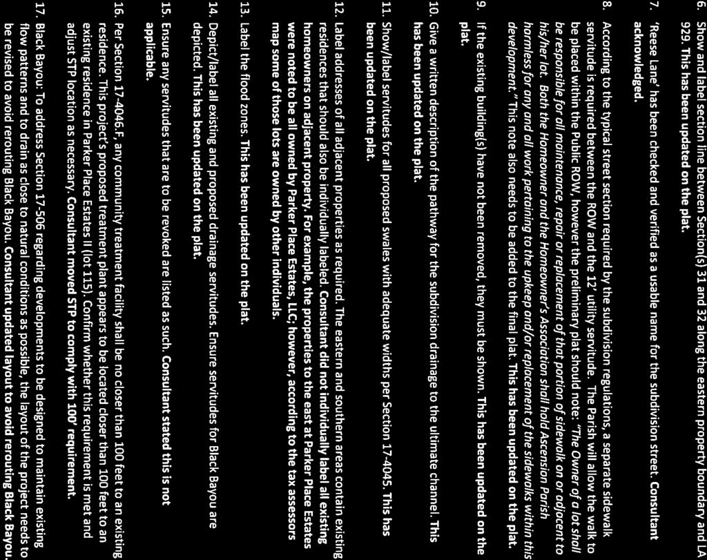
- Views:
Transcription
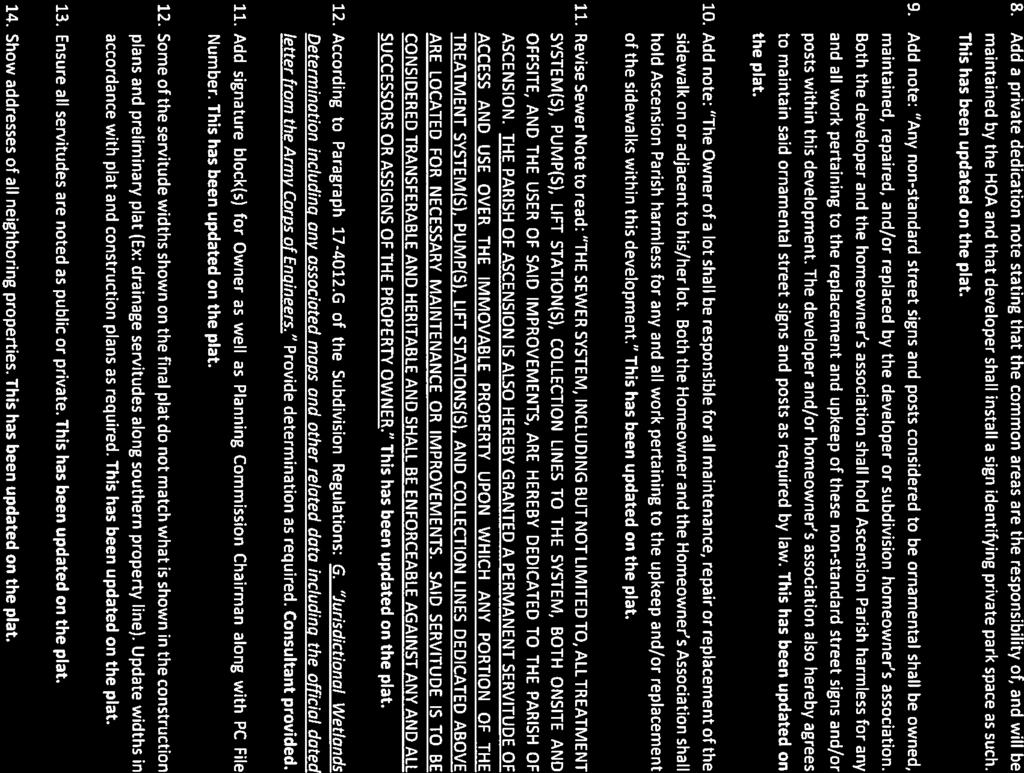
1 1. Call to Order 2. Roll Call of Members 3. Pledge of Allegiance 4. Introduction of Staff 5. Chairman's Comments 6. General Business 7. Minutes (A) 8. Consent Agenda PARISH OF ASCENSION OFFICE OF PLANNING AND DEVELOPMENT PLANNING DEPARTMENT Planning Commission June 14, :00 PM Courthouse East, 2nd Floor, Council Meeting Room Gonzales, Louisiana AGENDA Approval or Denial of the Minutes and Written Decisions of the May 10, 2017 Planning Commission Meeting 9. Public Hearing to Approve or Deny the Following Family Partition: (A) John L. Gautreau Property - Lots 2N-1 and 2N-2 McLin Taylor, Inc. (Council District 11) (B) Riley Denham Property - Lots 5C2-A and 5C2-B Earles and Associates, LLC (Council District 6) (C) Riley Denham Property - Lots 5C4-A and 5C4-B Earles and Associates, LLC (Council District 6) (D) Nelson Gautreau Property - Lots B-1-A and B-1-B Earles and Associates, LLC (Council District 9) (E) Nelson Gautreau Property - Lots C-1 and C-2 Earles and Associates, LLC (Council District 9)
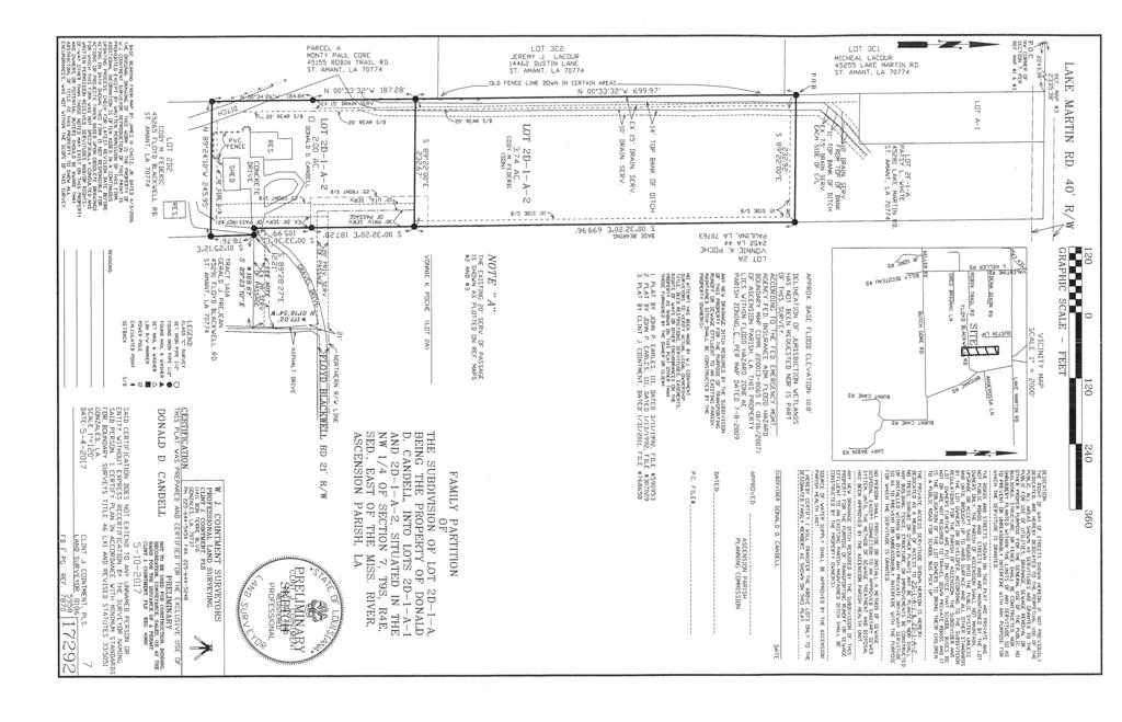
2 (F) Donald D. Candell Property - Lots SD-1-A-1 and SD-1-A-2 W J Cointment Surveyors (Council District 6) (G) Todd Elisar Property - Lots A-4-A and A-4-B W J Cointment Surveyors (Council District 9) (H) Kenneth Joffrion Property - Lots K-1, K-2, K-3, K-4 and K-5 W J Cointment Surveyors (Council District 8) (I) John K. Parker Property - Tracts S-1 and S-2 W J Cointment Surveyors (Council District 6) 10.Public Hearing to Approve or Deny the Following Preliminary Plats: (A) Reese Lane Quality Engineering & Surveying, LLC (Council District 7) 11.Public Hearing to Approve or Deny the Following Subdivision Final Plat: (A) Myrtle Grove Townhomes MR Engineering & Surveying, LLC (Council District 4) (B) Pelican Point Golf Community 13th Filing, Part 3 (The Greens - Phase IV, Part 2) Ferris Engineering & Surveying, LLC (Council District 2) This item was pulled from the agenda prior to the meeting by the engineer. 12.Staff Report 13.Engineering Staff Report 14.Adjourn
3 Description: Approval or Denial of the Minutes and Written Decisions of the May 10, 2017 Planning Commission Meeting ATTACHMENTS: Description Upload Date Type May Planning Commission Minutes 6/1/2017 Cover Memo Attachment A-D to PC Minutes /1/2017 Cover Memo Attachment F to PC Minutes 6/1/2017 Cover Memo
4 The below minutes and written decisions are taken from the meeting to represent items addressed and actions taken by this board. All meetings are recorded with video and audio for our records. In the event these minutes and written decisions are ever in question or controversy, the audio/video archive shall be used to determine the actual item or action taken by individuals present at this meeting. MINUTES AND WRITTEN DECISIONS PLANNING COMMISSION MAY 10, 2017 The Planning Commission of the Parish of Ascension held a Public Meeting on Wednesday, May 10, 2017 at 6:00 p.m. in the Courthouse East Meeting Room, Gonzales, Louisiana in a regular session convened. I. Meeting was Called to Order Meeting was called to order by Chairman Matthew Pryor. II. Roll Call of Members The following members were present: Wade Schexnaydre, Aaron Chaisson, Anthony Christy, Matthew Pryor, Morrie Bishop, Ken Firmin, Julio Dumas The following members were absent: None III. Pledge of Allegiance IV. Introduction of Staff Stacie Webb Secretary, Planning and Development Cody Martin Legal Counsel Jerome Fournier Director, Planning and Development Eric Poche Planner Lance Brock Zoning Official Shaun Sherrow Engineering Review Agent Joey Tureau Chief Engineer The Chairman recognized Councilman Doc Satterlee in the audience. V. Chairman s Comments The Chairman expressed the new Commission had gotten off to a rocky start in April. Mr. Dumas was out with medical issues. Mr. Pryor himself was in a trial. Two new members joined the Commission, Mr. Schexnaydre and Mr. Firmin. Mr. Anthony Christy filled in for Mr. Pryor for the April meeting as well. VI. Approval or Denial of the Minutes and Written Decisions of the April 12, 2017 Planning Commission Meeting Commission Action: Moved by Mr. Aaron Chaisson, seconded by Mr. Ken Firmin and unanimously adopted, to approve the Minutes and Written Decisions of the April 12, 2017 Planning Commission meeting as present.
5 Planning Commission Minutes May 10, 2017 Page 2 VII. Consent Agenda A) Affidavit of Mortgage David P. Singletary Lot 3-X-A (44159 Tom Watson Rd, St. Amant, LA) B) Affidavit of Mortgage Danny and Tina Clause Lot V-1-A-2 (40480 Gaidon Dr, Gonzales, LA) C) Affidavit of Mortgage Jeff M. Gautreau Lot 1-B (40355 Hwy 621, Gonzales, LA 70737) Commission Action: Moved Mr. Ken Firmin, seconded by Mr. Julio Dumas and unanimously adopted, to approve the consent agenda. VIII. Public Hearing to Approve or Deny the Following Family Partitions: A) Nelson Ross Property Lots B-1-C, B-1-D, B-1-E and B-1-F The subject property is located on the south side of LA Hwy 936 approximately 2,600 east of Melancon Road in Council District 2 and is zoned Rural (R). The application is on behalf of Nelson Ross by McLin-Taylor, Inc. The owner is proposing a family partition of a portion of Lot B-1 ( acres) into Lot B-1-C (2.020 acres), Lot B-1-D (1.010 acres), Lot B-1-E (1.010 acres) and Lot B-1-F (1.010 acres). He is also performing a simple division of the remainder of Lot B-1 into Lot B-1-A (1.248 acres) and Lot B-1-B (19.396). The applicant will retain Lot B-1-C and transfer Lot B-1-D (1.010 acres) to a grandson, Lot B-1-E (1.010 acres) to a grandson and Lot B-1-F (1.010 acres) to a grandson. STAFF REVIEW COMMENTS Comments sent to Ellen Jackson at McLin-Taylor, Inc. on : 1. Zoning category is incorrectly listed as RM. This property is in a Rural zoning category. 2. Side setback is 10 in Rural zoning category. 3. Add, or 75 from the centerline of a state highway to front setback note. 4. Private dedication statement needs to be amended to fit lot numbers without covering other text. 5. Bayou Francois servitude references Reference No. 2 which is not included on the map. Please include. 6. The servitude of passage is 40 in the front of the property and 30 in the rear. The minimum is 30, however be consistent for the entirety of the servitude. If it was originally dedicated as 40, make 40 all the way through. STAFF RECOMMENDATIONS This property division meets the requirements of the family partition section of the subdivision regulations. The owner(s) have owned the property for at least three years or prior to January 1, 2015 as required by Paragraph B. Should the commission concur with the staff analysis, staff recommends approval
6 Planning Commission Minutes May 10, 2017 Page 3 contingent on addressing all comments on the final map as listed above and the required conveyance documents being completed and recorded according to Paragraph F of the Subdivision Regulations. Ms. Ellen Jackson with McLin Taylor, Inc. presented this family partition. Public hearing was opened. No comments. Public hearing was closed. Commission Action: Moved by Mr. Julio Dumas, seconded by Mr. Aaron Chaission and unanimously adopted, to approve this family partition as presented. B) Winifred Causey Estates Lots 6-B-1-A and 6-B-1-B The subject property is located on the south side of Riverside Drive approximately 900 east of Leo Causey Road in Council District 5 and is zoned Conservation (C). The application is on behalf of William A. King, III by Quality Engineering and Surveying, LLC. The owner is proposing a family partition of Lot 6-B-1 ( acres) into Lot 6- B-1-A (1.430 acres) and Lot 6-B-1-B (8.877 acres). The applicant will retain Lot 6-B-1-B and transfer Lot 6-B-1-A to his daughter. STAFF REVIEW COMMENTS Comments sent to Quality Engineering and Surveying on : 1. Revise sheet title to reference parent tract, Winifred Causey Estate. We want the project 2. Delineate site clearly and add North arrow to vicinity map. 3. Add, or 55 from the roadway centerline to the front setback information utility servitude must run all the way to the access ROW and cannot be contained within the 30 servitude of access. 5. The 30 servitude of access must have a 30 x 90 t-turnaround area. STAFF RECOMMENDATIONS This property division meets the requirements of the family partition section of the subdivision regulations. The owner(s) have owned the property for at least three years or prior to January 1, 2015 as required by Paragraph B. Should the commission concur with the staff analysis, staff recommends approval contingent on addressing all comments on the final map as listed above and the required conveyance documents being completed and recorded according to Paragraph F of the Subdivision Regulations. Mr. George McCallum with Quality Engineering & Surveying, LLC presented this family partition. Public hearing was opened.
7 Planning Commission Minutes May 10, 2017 Page 4 No comments. Public hearing was closed. Commission Action: Moved by Mr. Julio Dumas, seconded by Mr. Anthony Christy and unanimously adopted, to approve this family partition as presented. C) Joella Woodford Property Lots A, B & C The subject property is located on the south side of LA Hwy 621 approximately 1,900 east of George Rouyea Road in Council District 9 and is zoned Medium Intensity Residential (RM). The application is on behalf of Joella Woodford by Quality Engineering and Surveying, LLC. The owner is proposing a family partition of an unnamed lot (1.709 acres) into Tract A (0.939 acres) and Tract B (0.500 acres). The applicant will retain Tract A and transfer Tract B to her daughter. Through this application, there will be an exchange of property with Lot C. STAFF REVIEW COMMENTS Comments sent to Quality Engineering and Surveying on : 1. Show scale ( min.) and north arrow on vicinity map. Also, reduce line weight for streets on vicinity map for clarity. 2. A 12 utility servitude must run to tract B along servitude and cannot be contained within 30 private access servitude. 3. A 30 x 90 t-turnaround must be included at the end of the 30 private access servitude. 4. Repeated note under Sewage Disposal Note. Revise as necessary. 5. There is an existing 7.5 drainage servitude along the eastern boundary line of Tracts A, B & C according to Instrument No Revise map accordingly. 6. Front building line is 25 from the property line OR 75 from the centerline of a state highway, whichever is greater. Please note in legend and show on map. 7. Add daughter s name to map, when known. 8. Revise Dedication Statement to note Tract B and not Lot 6-B-1-A. STAFF RECOMMENDATIONS This property division meets the requirements of the family partition section of the subdivision regulations. The owner(s) have owned the property for at least three years or prior to January 1, 2015 as required by Paragraph B. Should the commission concur with the staff analysis, staff recommends approval contingent on addressing all comments on the final map as listed above and the required conveyance documents being completed and recorded according to Paragraph F of the Subdivision Regulations. Mr. George McCallum with Quality Engineering & Surveying, LLC presented this family partition.
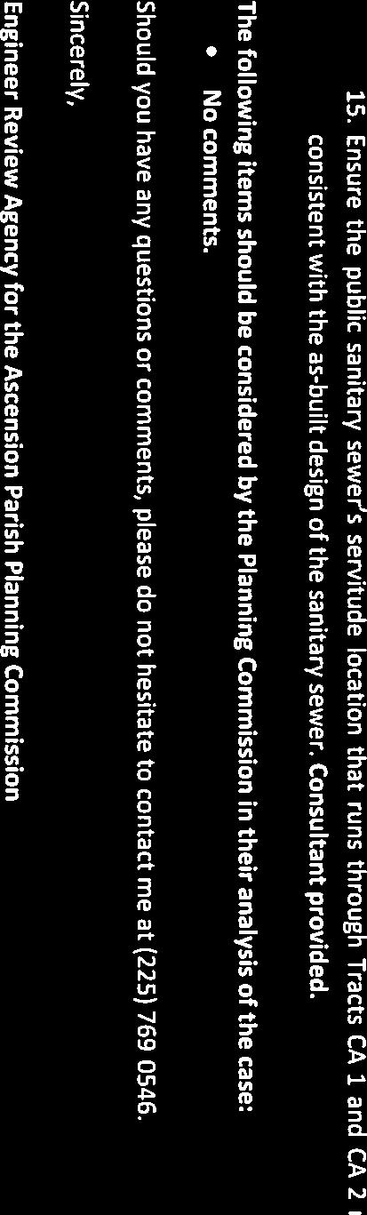
8 Planning Commission Minutes May 10, 2017 Page 5 Public hearing was opened. No comments. Public hearing was closed. Commission Action: Moved by Mr. Ken Firmin, seconded by Mr. Aaron Chaisson and unanimously adopted, to approve this family partition as presented. IX. Public Hearing to Approve or Deny the Following Subdivision Preliminary Plat: A) Reese Lane Quality Engineering & Surveying, LLC (Council District 7) This item was pulled from the agenda prior to meeting by the engineer. X. Public Hearing to Approve or Deny the Following Subdivision Final Plats: A) Sorrento Pipeline Company, LLC Revision Tract 1 and 2 The subject property is located on Texaco Drive approximately 4,400 feet east of U.S. Hwy. 61 (Airline Hwy.) in Council District 2 and is currently zoned as Conservation (C). The application is on behalf of Sorrento Pipeline Company, LLC by Morris P. Hebert, Inc. From a 1,920.--± acre tract (Unnamed Tract), two (2) tracts are being removed: 1. Tract 1, an 8.91 acre tract is being removed and has access along a 50 private access servitude (Texaco Drive) extending from U.S Tract 2, a 1.09± acre tract is being removed and has access along a 50 private access servitude (Texaco Drive) extending from U.S. 61. A waiver of providing lot frontage on a public street is being requested for the division of tracts in items 1 and 2 listed above. All acreage in the unnamed parent tract is zoned C (Conservation). REVIEW COMMENTS-Submitted to Morris P. Hebert, Inc. on April 18, Note zoning category of property on sheet 1 with setbacks listed. Zoning is Conservation (C) with 25 front b/l, 20 rear b/l and 10 side b/l. Plat has been corrected. 2. There looks to be an existing building on Part B of Tract 1. Verify and include on map if necessary. Plat has been corrected. 3. A 12 access servitude must be included parallel to road frontage. This may be included in the 50 private access servitude but must be noted on the map. Plat has been corrected. 4. Add, into the public system unless and UNTIL said road is to note 8 on Sht. 2. Plat has been corrected. 5. Verify Existing Texaco ROW Instrument No. on Sheet 2. Plat has been corrected. 6. Label Lease Site E as Tract A. Plat has been corrected.
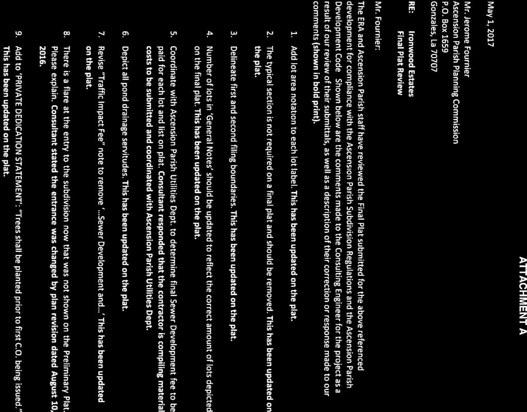
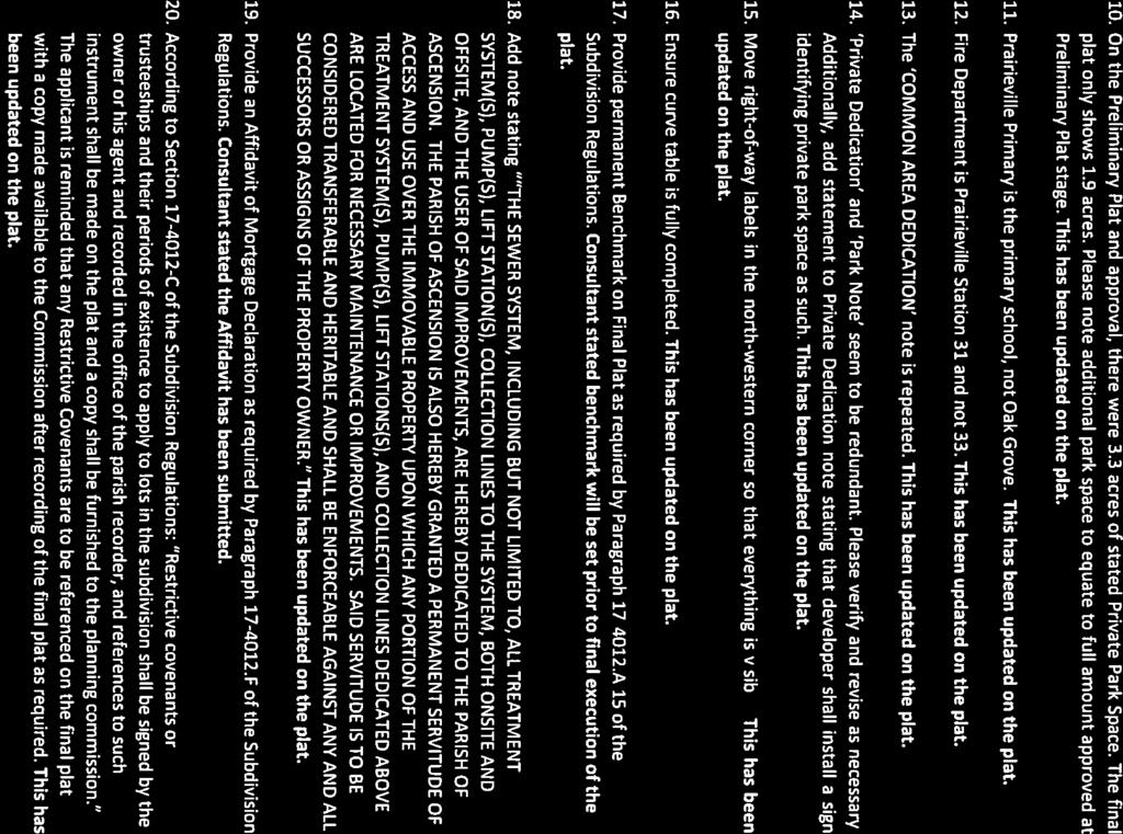
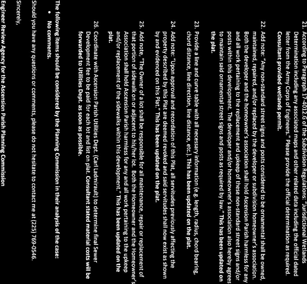
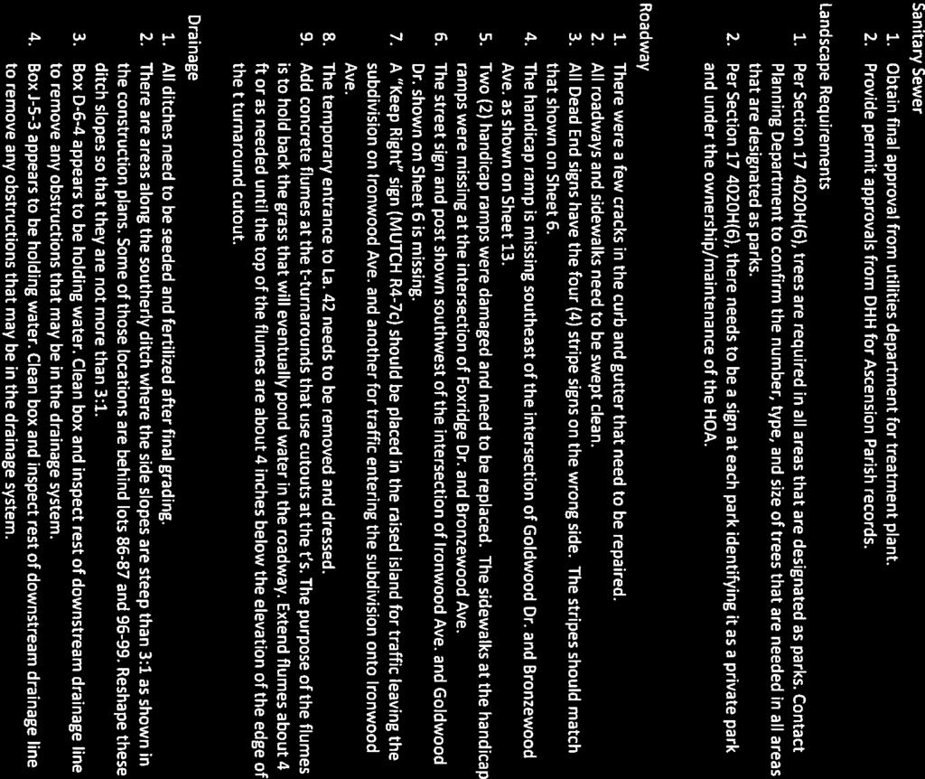
9 Planning Commission Minutes May 10, 2017 Page 6 7. On Certification note, add statement of compliance with LA RS 33:5051. Plat has been corrected. 8. With reference to Note 2 on Sheet 2, please note that if the legal description (Exhibit B) is to accompany the plat, this document will have 3 sheets and not 2. If this is an incorrect assumption, please clarify. Consultant has included additional information and renumbered exhibits as required. STAFF RECOMMENDATIONS Staff has reviewed this application and recommends approval of the request for waiver and the subdivision of these tracts. All facilities and tracts contained within this property are accessible along the existing ROW and/or servitude of access and have improved roadways maintained by the industrial companies that they serve. Should the Planning Commission agree with the Staff s assessment, Staff recommends approval. Mr. Jerry Richie representing Sorrento Pipeline Company, LLC presented this final plat revision. Public hearing was opened. No comments. Public hearing was closed. Commission Action: Moved by Mr. Wade Schexnaydre, seconded by Mr. Ken Firmin and unanimously adopted, to approve this revision to subdivision final plat as presented. B) Pelican Point Golf Community 13 th Filing, Part 3 The Greens Phase IV, Part 2 Ferris Engineering & Surveying, LLC (Council District 2) This item was pulled from the agenda prior to meeting by the engineer. C) Ironwood Estates The subject property is located on the south side of LA Hwy 42 approximately 2,180 feet west of La Hwy 929 in Council District 11and is zoned Mixed Use 2 (MU2). The application is on behalf of DAGR, LLC by Centerline Engineering & Land Surveying, LLC. The property is 43.4 acres and the applicant has constructed a major subdivision containing 130 single family residential lots and 1 commercial tract. The property is accessed on the north by LA Hwy 930. Typical lot widths range from 50 to 70 feet with a minimum size of 6,250 square feet. The subdivision includes 5.1 acres of designated park space and complies with the major subdivision regulations. Project Timeline: October 14, Planning Commission approves the preliminary plat June 16, Construction plans approved. April 27, 2017 Final Inspection Performed
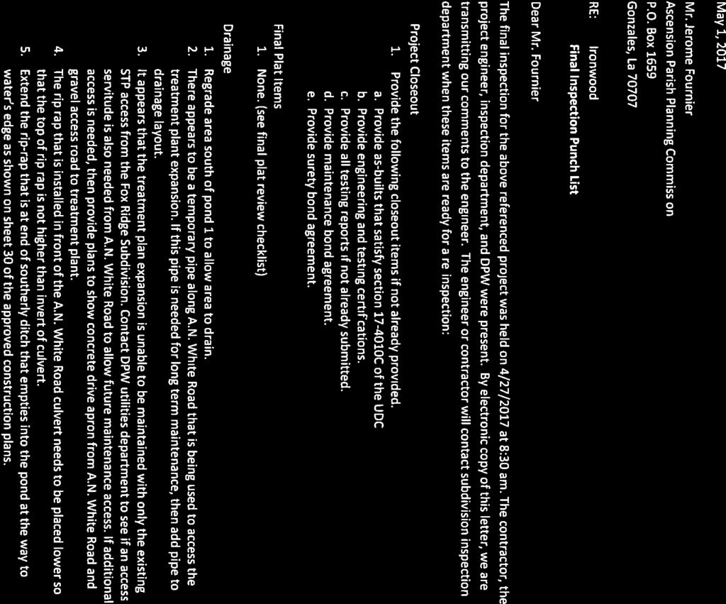
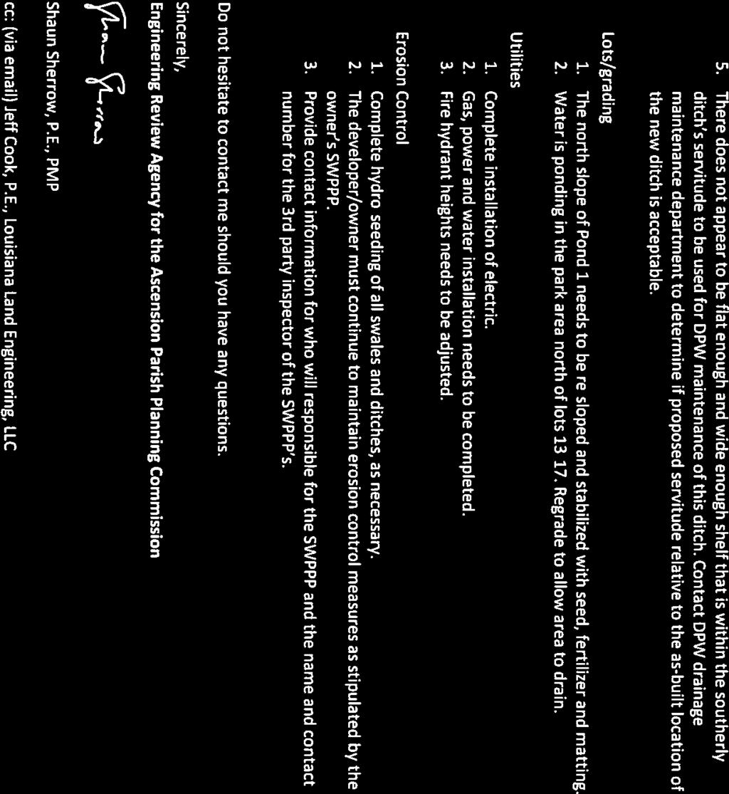
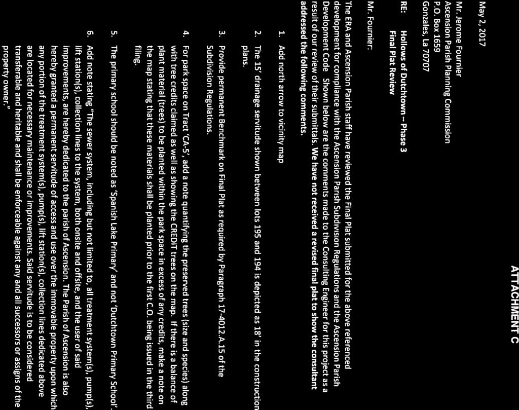
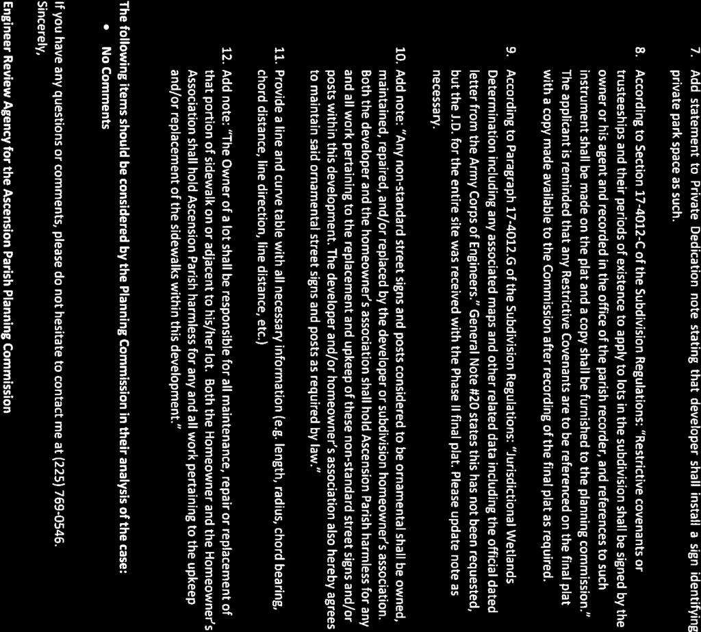
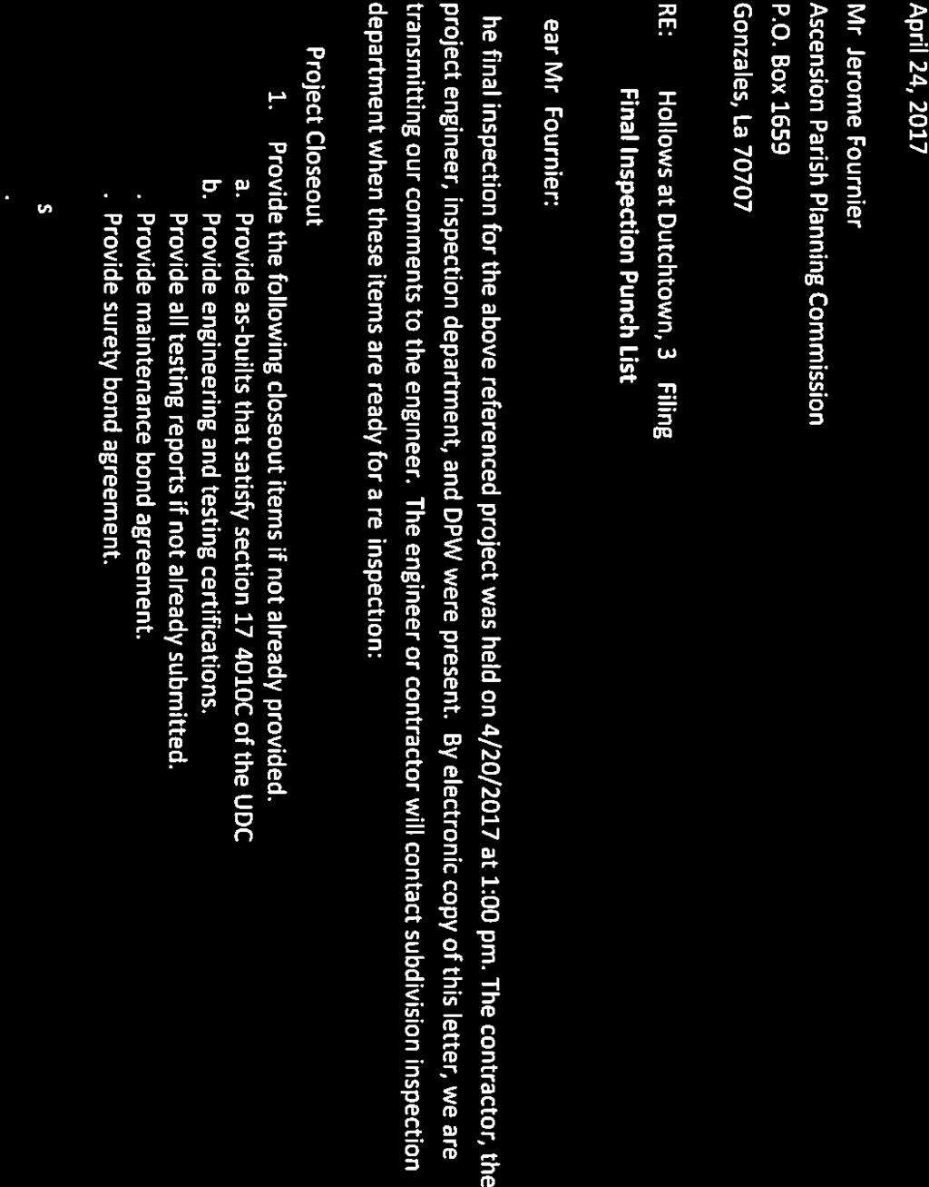
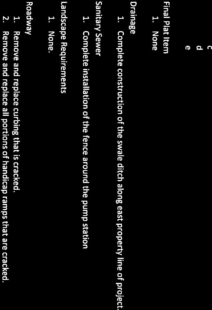
10 Planning Commission Minutes May 10, 2017 Page 7 STAFF/ERA FINAL PLAT REVIEW COMMENTS (see attached Final Plat Comments) ATTACHEMENT A ENGINEERING DEPT/ERA OUTSTANDING ITEMS: (see attached punch list from final inspection) ATTACHMENT B STAFF RECOMMENDATIONS Staff recommends approval contingent upon satisfactory completion of all outstanding final plat comments and punch list items. Note: Signature by the Planning Commission Chairman shall be withheld until all items have been completed as noted. Mr. Jeff Cook with Louisiana Land Engineering, LLC presented this subdivision final plat. Public hearing was opened. No comments. Public hearing was closed. Commission Action: Moved by Mr. Julio Dumas, seconded by Mr. Ken Firmin and unanimously adopted, to approve this subdivision final plat subject to all punch list items being addressed prior to the Chairman signing the plat. D) Hollows of Dutchtown, Phase 3 The proposed subdivision is located on La Hwy 73 approximately 342 feet north of LA Hwy 621 in Council District 4 and zoned Medium Intensity (RM) and Mixed Use (MU). The application is on behalf of Hollows of Dutchtown, LLC by MR Engineering & Surveying, LLC. The property consists of 3 tracts of land totaling acres. The applicant is submitting the final plat for Phase III consisting of 77 residential lots with a typical size of 65 x 160 and an area averaging 10,400 square feet. Once completed, the subdivision is planned to contain 193 lots, 65, 75, and 85 feet in width, with a minimum size of 9,750 square feet. The subdivision also contains a total of.97 acres of park space, including a pool and clubhouse (included in Phase I) with.51acres of park space included in Phase III and complies with the major subdivision regulations. The intent of the developer is to secure a performance bond for the value of the water utility, the fence around the lift station and the final grading and seeding in order to have the final plat signed prior to completion of these construction items. Should the use of a performance bond be acceptable to the Commission, the final plat will be held for signing and recordation until the bond is approved and executed and any remaining punch list items have been completed. Once all bonded construction items have been completed to the satisfaction of the Parish with proper paperwork and documentation, the bond will be released.
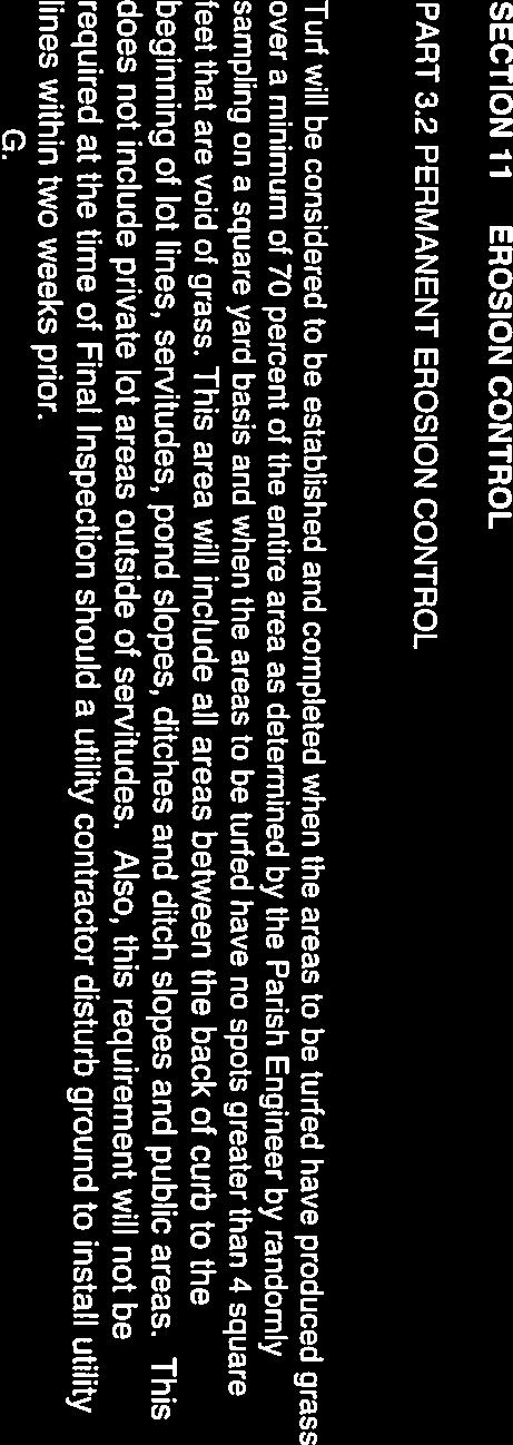
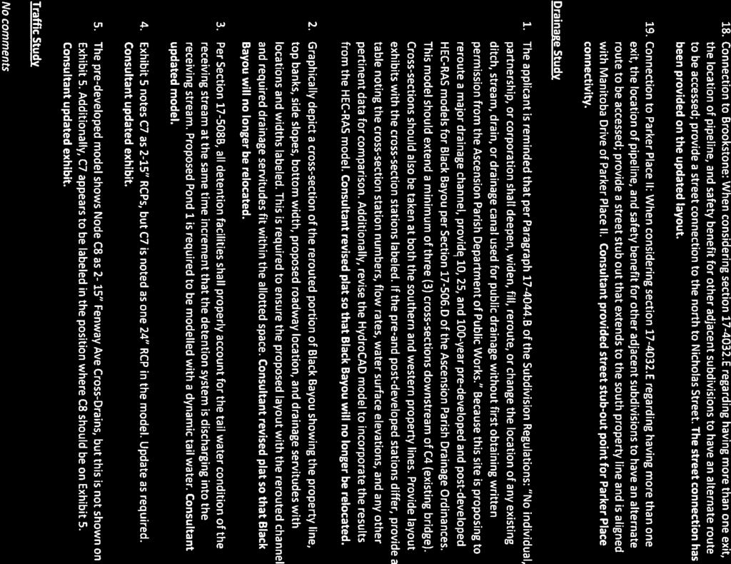
11 Planning Commission Minutes May 10, 2017 Page 8 Project Timeline: February 12, Planning Commission approves the preliminary plat August 13, Construction plans approved. April 20, 2017 Final Inspection Performed STAFF/ERA FINAL PLAT REVIEW COMMENTS (see attached Final Plat Comments) ATTACHMENT C ENGINEERING DEPT/ERA OUTSTANDING ITEMS: See attached punch list from final inspection. ATTACHMENT D STAFF RECOMMENDATIONS Staff recommends approval contingent upon satisfactory completion of all outstanding final plat comments and punch list items and the issuance, by the developer, of a performance surety bond to cover the incomplete subdivision improvements. Note: Signature by the Planning Commission Chairman shall be withheld until all items have been completed as noted. Mr. Mickey Robertson with MR Engineering & Surveying, LLC presented this subdivision final plat. Public hearing was opened. No comments. Public hearing was closed. Commission Action: Moved by Mr. Julio Dumas, seconded by Morrie Bishop and unanimously adopted, to approve this subdivision final plat subject to all punch list items being addressed prior to the Chairman signing the plat. XI. Ordinances Public Hearing to Recommend Approval or Denial to the Parish Council Amendments to the Ascension Parish Unified Land Development Code: A) Ordinance Add to and amend the Ascension Parish Unified Land Development Code pertaining to Subdivision Construction Specifications Mr. Jerome Fournier highlighted the proposed specifications. (See Attachment E) He expressed staff has been working with the development community as well as many of the engineering firms and contractors that work within the parish to compile the Ascension Parish Subdivision Construction Specifications. He stated these would be specifications that will hopefully, ultimately be adopted by the Parish Council and placed in the Ascension Parish Unified Land Development Code. These specifications will allow the builders to understand exactly what is going to be required of them when building in the Parish.
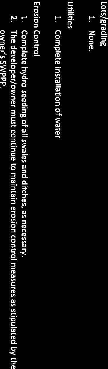
12 Planning Commission Minutes May 10, 2017 Page 9 XII. Old Business Mr. Fournier mentioned there is one minor change that has been made to the specifications since last month s meeting. It applies to Section 11 Erosion Control. (See Attachment F). Mr. Joey Tureau said this change was made after they had gotten feedback from a contractor with reference to erosion control items. It defines exactly what areas we want grass growth for erosion control so that more is not imposed than necessary. Mr. Joey Tureau further expressed these specifications would be official and be precisely as to what is needed. It will give the parish and the contractors something to refer to if ever there is confusion or controversy on what is required. It was said there is currently no ordinance in place for subdivision construction specifications, only guidelines that have been followed in the past. Public hearing was opened. The following spoke: Billy Aguillard Mr. Aguillard thanked the Staff for working with the engineers and contractors in this process. He said they worked diligently on it and listened to all comments and incorporated most things that were agreed on. He thinks this is a good ordinance. Public hearing was closed. Commission Action: Moved by Mr. Julio Dumas, seconded by Mr. Anthony Christy and unanimously adopted, to recommend approval to the Parish Council to add and amend the Ascension Parish Unified Land Development Code pertaining to Subdivision Construction Specifications along with the amendment that was delivered at this meeting. A) Steve Babin Property for Danny Guitreau Lots 1-A, 1-B & 1-C Family Partition The subject property is located on Alex King Road south of LA Hwy. 74 in Council District 8 and is zoned Medium Intensity (RM). The application is on behalf of Danny Guitreau by B.M. Aguillard & Associates, LLC. The owner is proposing a family partition of a Lot 1 (1.63 acres) into Lots 1-A (.544 acres), 1-B (.544 acres), and 1-C (.544 acres). The applicant will retain Lot 1-A, transfer lot 1-B to his son and transfer Lot 1-C to his daughter. STAFF COMMENTS This property division was approved at the March 8, 2017 planning commission meeting. The applicant has not been able to secure predial servitude agreement signatures from two property owners along the existing private servitude of
13 Planning Commission Minutes May 10, 2017 Page 10 passage as required by Paragraph D.2(c) of the Subdivision Regulations. Therefore, he is before you asking for a waiver of this requirement to allow him to complete the subdivision of property that was approved. Mr. Brian Aguillard with B.M. Aguillard & Associates, LLC presented this family partition waiver request. Public hearing was opened. No comments. XIII. Staff Report Public hearing was closed. Commission Action: Moved by Mr. Aaron Chaisson, seconded by Mr. Julio Dumas and unanimously adopted, to deny this family partition waiver request of not requiring a predial servitude agreement as required by Paragraph D.2(c) of the Subdivision Regulations. A) Discussion of the Use of Performance Surety Bonds Mr. Jerome Fournier stated Staff is asking that this agenda item be placed on next month s Planning Commission meeting agenda for public hearing to discuss the use and possibly change the use of performance surety bonds as outlined in the Unified Land Development Code. Mr. Fournier further expressed he will prepare documentation and have it submitted in the meeting packets to have available for discussion at the next meeting. Chairman Pryor clarified this would be discussion to eliminate the use of using performance surety bonds on subdivision completion. Mr. Fournier said there were other modifications to the code that would allow final plats not to go before the Planning Commission for final approval but make sure staff approves the signature of the map before it goes to the Chairman for signature. He said this would eliminate some of the time delays in signature of the final plat. Chairman Pryor asked Mr. Fournier to give the Planning Commission a proposal both with removal of presenting the final plat to the Planning Commission and without. XIV. Engineering Staff Report Mr. Shaun Sherrow gave a status report on projects: Approximately nine (9) subdivision projects in construction. Approximately four (4) subdivision projects in construction plan review.
14 Planning Commission Minutes May 10, 2017 Page 11 XV. Adjourn Moved by Mr. Julio Dumas, seconded by Mr. Anthony Christy and unanimously adopted, this meeting adjourned at 6:37 p.m. Matthew Pryor, Chairman
15
16

17

18
19
20
21
22
23
24
25
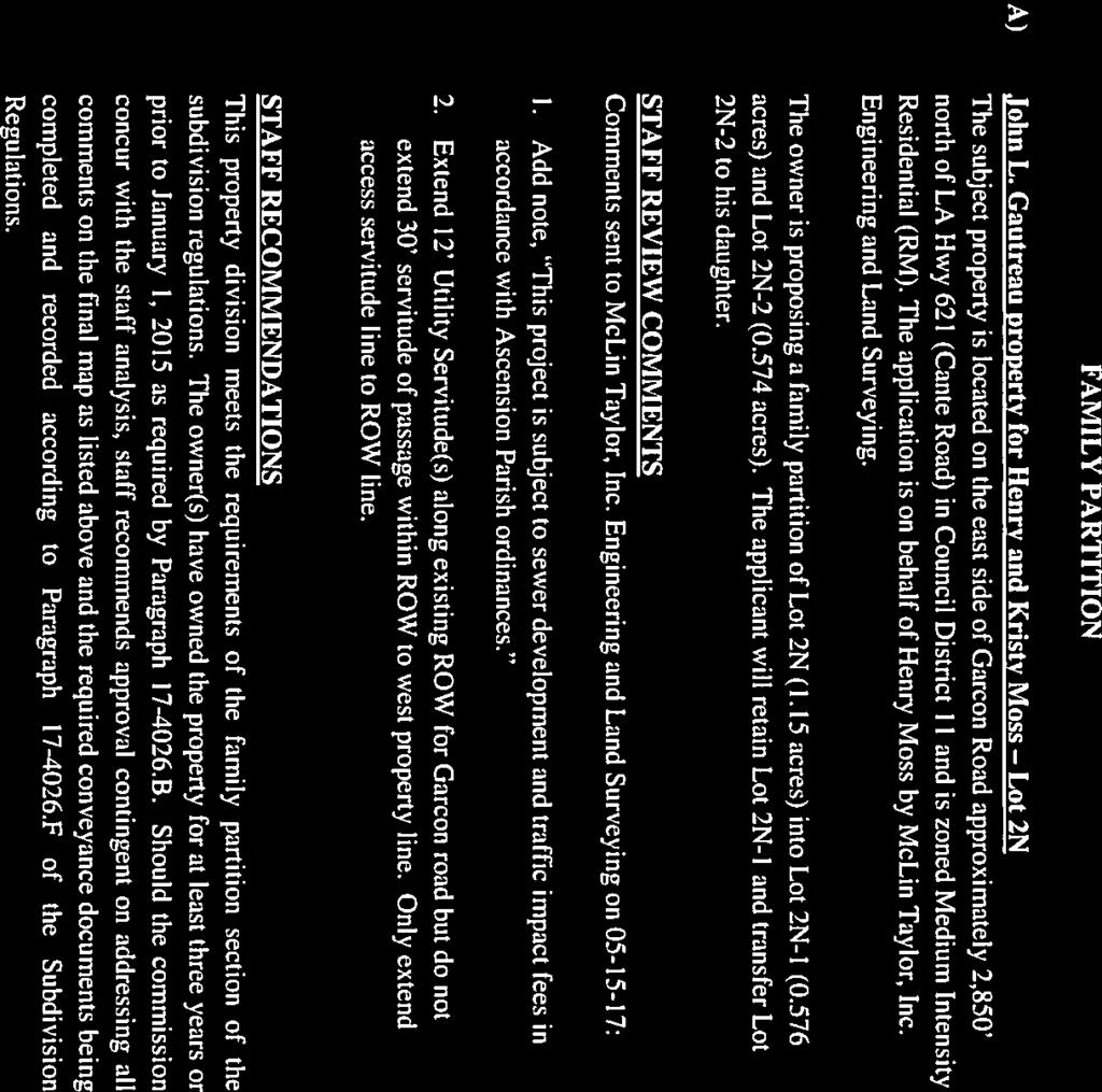
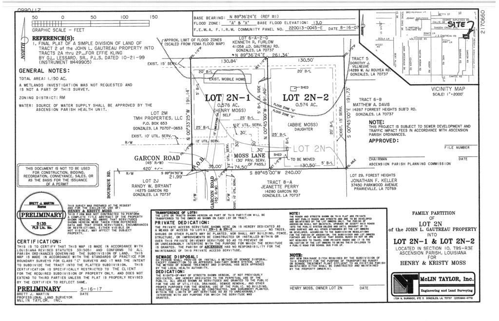
26 Description: John L. Gautreau Property - Lots 2N-1 and 2N-2 McLin Taylor, Inc. (Council District 11) ATTACHMENTS: Description Upload Date Type John L Gautreau 6/7/2017 Cover Memo John L Gautreau Prelim Plat 6/7/2017 Cover Memo
27
28
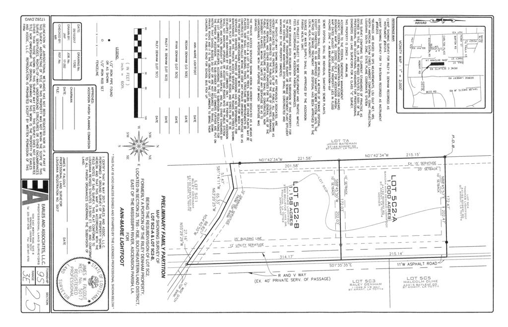
29 Description: Riley Denham Property - Lots 5C2-A and 5C2-B Earles and Associates, LLC (Council District 6) ATTACHMENTS: Description Upload Date Type Riley Denham - Lot 5C2 6/7/2017 Cover Memo Riley Denham Lot 5C2 Prelim Plat 6/7/2017 Cover Memo


30
31
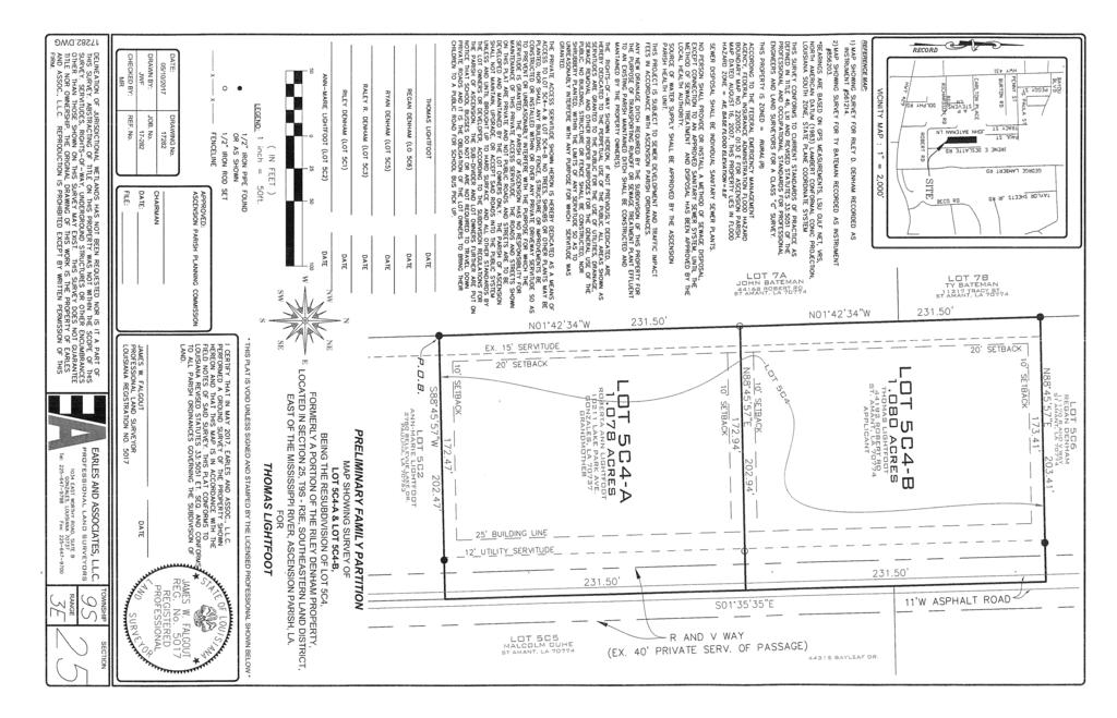
32 Description: Riley Denham Property - Lots 5C4-A and 5C4-B Earles and Associates, LLC (Council District 6) ATTACHMENTS: Description Upload Date Type Riley Denham - Lot 5C4 6/7/2017 Cover Memo Riley Denham Lot 5C4 Prelim Plat 6/7/2017 Cover Memo
33
34
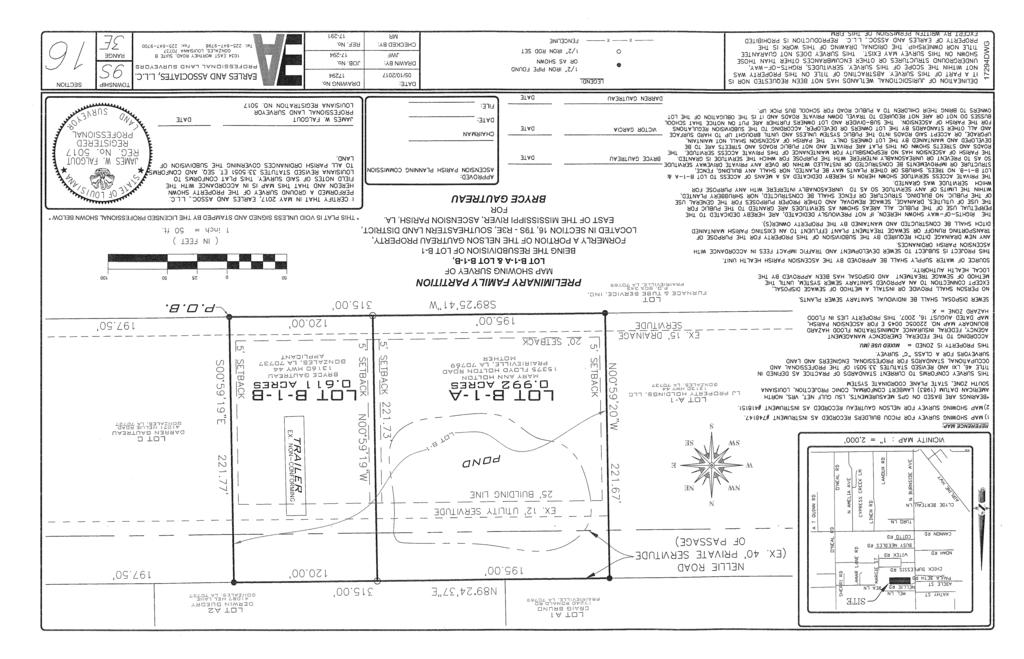
35 Description: Nelson Gautreau Property - Lots B-1-A and B-1-B Earles and Associates, LLC (Council District 9) ATTACHMENTS: Description Upload Date Type Nelson Gautreau - Lot B-1 6/7/2017 Cover Memo Nelson Gautreau Lot B-1 Prellim Plat 6/7/2017 Cover Memo
36
37
38 Description: Nelson Gautreau Property - Lots C-1 and C-2 Earles and Associates, LLC (Council District 9) ATTACHMENTS: Description Upload Date Type Nelson Gautreau - Lot C 6/7/2017 Cover Memo Nelson Gautreau Lot C Prelim Plat 6/7/2017 Cover Memo
39
40
41 Description: Donald D. Candell Property - Lots SD-1-A-1 and SD-1-A-2 W J Cointment Surveyors (Council District 6) ATTACHMENTS: Description Upload Date Type Donald D Cancell 6/7/2017 Cover Memo Donald D Candell Prelim Plat 6/7/2017 Cover Memo
42
43
44 Description: Todd Elisar Property - Lots A-4-A and A-4-B W J Cointment Surveyors (Council District 9) ATTACHMENTS: Description Upload Date Type Todd Elisar 6/7/2017 Cover Memo Todd Elisar Prelim Plat 6/7/2017 Cover Memo
45
46
47 Description: Kenneth Joffrion Property - Lots K-1, K-2, K-3, K-4 and K-5 W J Cointment Surveyors (Council District 8) ATTACHMENTS: Description Upload Date Type Kenneth Jofrion 6/7/2017 Cover Memo Kenneth Joffrion Prelim Plat 6/7/2017 Cover Memo
48
49
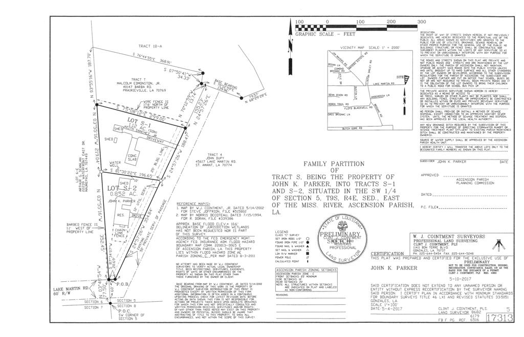
50 Description: John K. Parker Property - Tracts S-1 and S-2 W J Cointment Surveyors (Council District 6) ATTACHMENTS: Description Upload Date Type John K Parker 6/7/2017 Cover Memo John K Parker Prelim Plat 6/7/2017 Cover Memo
51
52
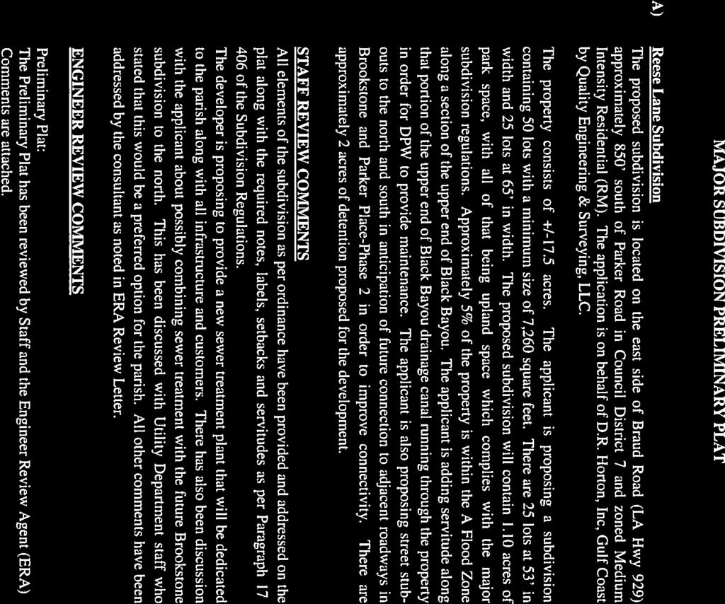
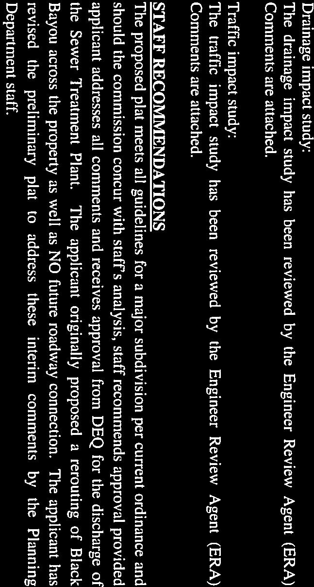
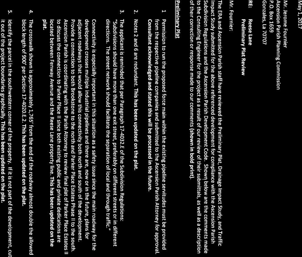
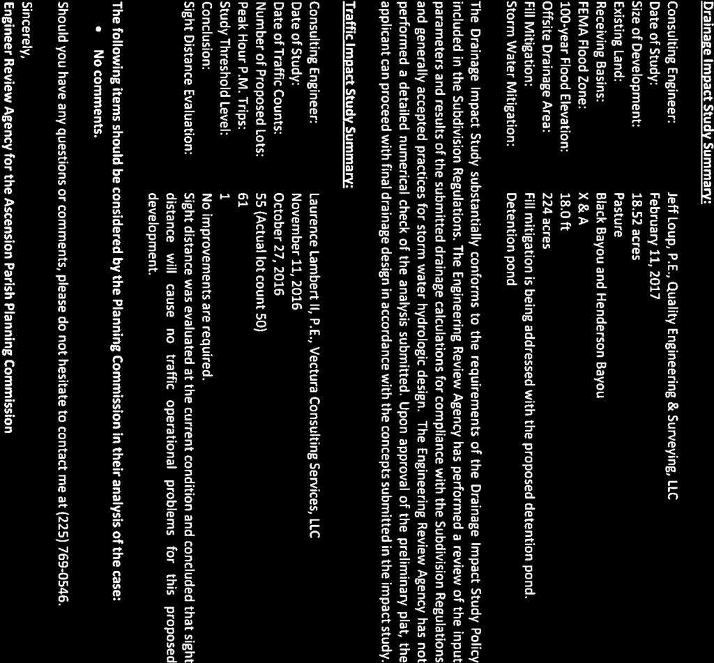
53 Description: Reese Lane Quality Engineering & Surveying, LLC (Council District 7) ATTACHMENTS: Description Upload Date Type Reese Lane 6/7/2017 Cover Memo Reese Lane Prelim Plat Review Ltr 6/7/2017 Cover Memo Reese Lane Prelim Plat 6/7/2017 Cover Memo
54
55
56
57
58
59
60 AIKENS RD MADISON COURT DR ERIC DR RENNES DR MEADOWVIEW DR SEC 33 SEC 28 TYPICAL LOT DETAIL: N.T.S. TYPICAL STREET SECTION (50' RIGHT-OF-WAY): N.T.S. LEGEND: SIDEWALK SECTION: N.T.S. N VICINITY MAP: DAIGLE RD SEC 31 WEST LN A N WHITE RD TILLOTSON RD OAKVIEW DR HUNTER'S TRACE W TRACE E CREEK AVE WILLOW LN MEADOWBROOK AVE SAMUEL TILLOTSON DR TAMMY RD LA RITZ RD HUNTER'S SEC 30 FOX RIDGE LAKELAND AVE QUAIL GERRIE DR AL DR GREGG DR MADISON AVE CULLY BROUSSARD RD AIMEE DR HWY 42 ALISE AVE PARKER RD HWY 933 NATALIE LN MARIE RD RONDA AVE TODD DR BARBARA RD LA ROCHELLE RD SITE MEGAN LN BORDEAUX ST LACEY LN FOUNTAINBLEAU DR ALLEMAN LN ABBY JAMES RD RENNES DR SCALE: 1" = 2000' SEC 29 NICHOLLS PARKER HEIGHTS RD THAIS RD N BURNSIDE AVE ETHEL ST N BURNSIDE AVE BRADBURY LN BAYRIDGE DR PATTY JO LN BOLIVAR DR MELANCON RD LOUIS RD LOTTIE RD SEC 32 MYRTLE ST TIGER HEIGHTS RD W LAKEPOINT CT LAKEPOINT DR ACADIA DR CAUSEY RD HWY 929 TRACT "STP" TRACT "CA1" TRACT "CA3" REESE LANE TRACT "CA2" FLOOD ZONE "X" FLOOD ZONE "A" FLOOD ZONE "X" CONTOUR NOTE: GENERAL NOTES: FLOOD ZONE NOTE: PRELIMINARY PLAT SEWAGE DISPOSAL NOTE: OUTFALL NOTE: TITLE: PRELIMINARY PLAT GENERAL SUBDIVISION INFORMATION: PUBLIC DEDICATION: LOT COUNT: PROJECT: REESE LANE TREE AND PARK REQUIREMENTS: DESCRIPTION: LOCATED IN SECTION 32, TOWNSHIP 8 SOUTH, RANGE 3 EAST, SOUTH EAST LAND DISTRICT, EAST OF THE MISSISSIPPI, ASCENSION PARISH, LOUISIANA LOT OWNERS (NOW OR FORMERLY) CLIENT: D.R. HORTON, INC. - GULF COAST DENHAM SPRINGS, LOUISIANA QUALITY Engineering & Surveying, LLC Hwy 42 Port Vincent, LA TEL FAX Project No.: Date: APRIL 28, 2017 Drawn By: DHM DWG Path:
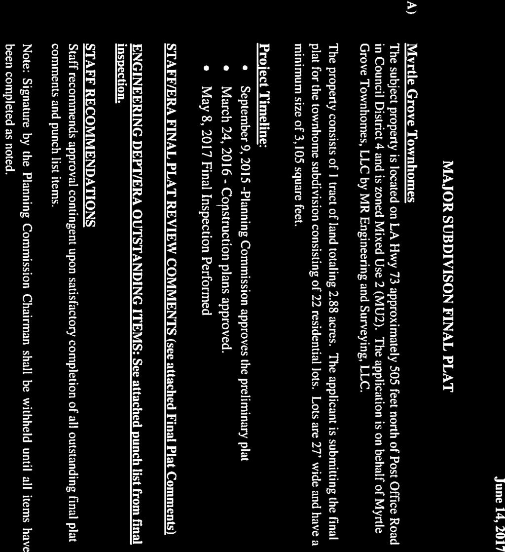
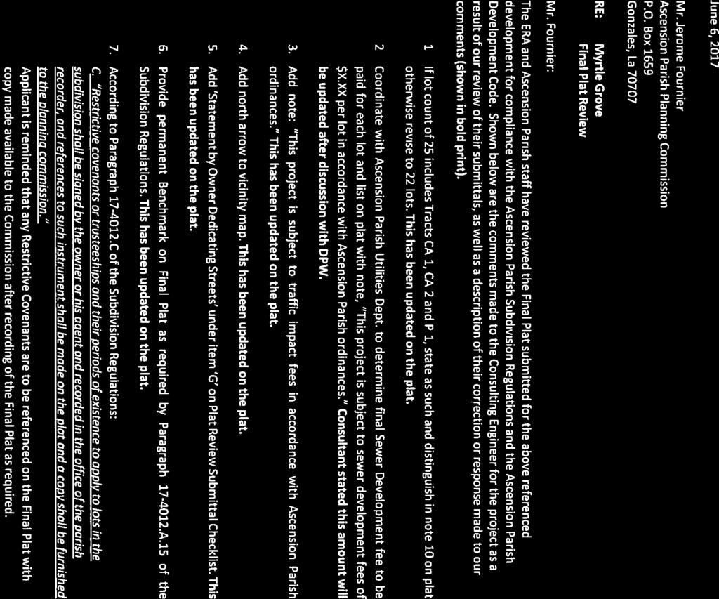
61 Description: Myrtle Grove Townhomes MR Engineering & Surveying, LLC (Council District 4) ATTACHMENTS: Description Upload Date Type Myrtle Grove Townhomes 6/7/2017 Cover Memo Myrtle Grove Townhomes Minutes of /7/2017 Cover Memo Myrtle Grove Townhomes Final Plat Review Ltr 6/7/2017 Cover Memo Myrtle Gove Townhomes approved Prelim Plat 6/7/2017 Cover Memo Myrtle Grove Townhomes Final Plat 6/7/2017 Cover Memo
62
63
64
65
66
67
")
68 TRACTS CA-1, CA-2, CA-3 & TRACT P-1 LOT 1-C REQ'D. GREENSPACE: LOT DATA RECREATIONAL SPACE (PROVIDED)
69
70 Description: Pelican Point Golf Community 13th Filing, Part 3 (The Greens - Phase IV, Part 2) Ferris Engineering & Surveying, LLC (Council District 2) This item was pulled from the agenda prior to the meeting by the engineer.
MINUTES PLANNING COMMISSION August 10, 2016
 The below minutes are taken from the meeting to represent items addressed and actions taken by this board. All meetings are recorded with video and audio for our records. In the event these minutes are
PARISH OF ASCENSION OFFICE OF PLANNING AND DEVELOPMENT PLANNING DEPARTMENT
 1. Call to Order 2. Roll Call of Members 3. Pledge of Allegiance 4. Introduction of Staff 5. Chairman's Comments 6. Minutes (A) 7. Consent Agenda (A) PARISH OF ASCENSION OFFICE OF PLANNING AND DEVELOPMENT
MINUTES PLANNING COMMISSION July 13, Meeting was called to order by Chairman Matthew Pryor.
 The below minutes are taken from the meeting to represent items addressed and actions taken by this board. All meetings are recorded with video and audio for our records. In the event these minutes are
MINUTES AND WRITTEN DECISIONS PLANNING COMMISSION DECEMBER 13, Meeting was called to order by Chairman Matthew Pryor.
 The below minutes and written decisions are taken from the meeting to represent items addressed and actions taken by this board. All meetings are recorded with video and audio for our records. In the event
PARISH OF ASCENSION OFFICE OF PLANNING AND DEVELOPMENT PLANNING DEPARTMENT. Planning Commission
 1. Call to Order 2. Roll Call of Members 3. Pledge of Allegiance 4. Introduction of Staff 5. Chairman's Comments 6. General Business 7. Minutes (A) 8. Consent Agenda PARISH OF ASCENSION OFFICE OF PLANNING
PARISH OF ASCENSION OFFICE OF PLANNING AND DEVELOPMENT PLANNING DEPARTMENT. Zoning Meeting
 PARISH OF ASCENSION OFFICE OF PLANNING AND DEVELOPMENT PLANNING DEPARTMENT 1. Meeting Called to Order by Chairman 2. Roll Call of Members 3. Minutes (A) Zoning Meeting February 13, 2019 Courthouse Annex
PARISH OF ASCENSION OFFICE OF PLANNING AND DEVELOPMENT PLANNING DEPARTMENT. Planning Commission
 1. Call to Order 2. Roll Call of Members 3. Pledge of Allegiance 4. Introduction of Staff 5. Chairman's Comments 6. General Business PARISH OF ASCENSION OFFICE OF PLANNING AND DEVELOPMENT PLANNING DEPARTMENT
PARISH OF ASCENSION OFFICE OF PLANNING AND DEVELOPMENT PLANNING DEPARTMENT. Planning Commission
 1. Call to Order 2. Roll Call of Members 3. Pledge of Allegiance 4. Introduction of Staff 5. Chairman's Comments 6. General Business (A) 7. Minutes (A) 8. Consent Agenda (A) (B) PARISH OF ASCENSION OFFICE
MINUTES PLANNING COMMISSION April 13, 2011
 The below minutes are taken from the meeting to represent items addressed and actions taken by this board. All meetings are recorded with video and audio for our records. In the event these minutes are
MINUTES Planning Commission October 14, 2015
 The below minutes are taken from the meeting to represent items addressed and actions taken by this board. All meetings are recorded with video and audio for our records. In the event these minutes are
PARISH OF ASCENSION OFFICE OF PLANNING AND DEVELOPMENT PLANNING DEPARTMENT
 1. Call to Order 2. Roll Call of Members 3. Pledge of Allegiance 4. Introduction of Staff 5. Chairman's Comments 6. General Business 7. Minutes (A) (B) 8. Consent Agenda (A) (B) (C) PARISH OF ASCENSION
MINUTES PLANNING COMMISSION July 10, 2013
 The below minutes are taken from the meeting to represent items addressed and actions taken by this board. All meetings are recorded with video and audio for our records. In the event these minutes are
PARISH OF ASCENSION OFFICE OF PLANNING AND DEVELOPMENT ZONING DEPARTMENT. Board of Adjustments
 1. Called to Order 2. Roll Call of Members 3. Public Comments 4. Acceptance of the Minutes (A) PARISH OF ASCENSION OFFICE OF PLANNING AND DEVELOPMENT ZONING DEPARTMENT Board of Adjustments July 26, 2016-6:00
PARISH OF ASCENSION OFFICE OF PLANNING AND DEVELOPMENT PLANNING DEPARTMENT. Planning Commission
 1. Call to Order 2. Roll Call of Members 3. Pledge of Allegiance 4. Introduction of Staff 5. Chairman's Comments (A) PARISH OF ASCENSION OFFICE OF PLANNING AND DEVELOPMENT PLANNING DEPARTMENT Planning
PARISH OF ASCENSION OFFICE OF PLANNING AND DEVELOPMENT ZONING DEPARTMENT
 1. Called to Order 2. Roll Call of Members 3. Public Comments 4. Acceptance of the Minutes (A) PARISH OF ASCENSION OFFICE OF PLANNING AND DEVELOPMENT ZONING DEPARTMENT Board of Adjustments April 28, 2015-6:00
MINUTES Planning Commission October 14, 2009
 The below minutes are taken from the meeting to represent items addressed and actions taken by this board. All meetings are recorded with video and audio for our records. In the event these minutes are
PARISH OF ASCENSION OFFICE OF PLANNING AND DEVELOPMENT PLANNING DEPARTMENT. Joint Planning and Zoning Meeting
 1. Call To Order 2. Roll Call of Members 3. Minutes PLANNING DEPARTMENT Joint Planning and Zoning Meeting March 14, 2018 6:00 PM Courthouse Annex - 828 Irma Blvd Council Meeting Room 2nd Floor (Following
PARISH OF ASCENSION OFFICE OF PLANNING AND DEVELOPMENT PLANNING DEPARTMENT
 PARISH OF ASCENSION OFFICE OF PLANNING AND DEVELOPMENT PLANNING DEPARTMENT 1. Meeting Called to Order by Chairman 2. Roll Call of Members 3. Pledge of Allegiance 4. Introduction of Staff 5. Minutes (A)
PARISH OF ASCENSION OFFICE OF PLANNING AND DEVELOPMENT PLANNING DEPARTMENT. Planning Commission
 1. Call to Order 2. Roll Call of Members 3. Pledge of Allegiance 4. Introduction of Staff 5. Chairman's Comments 6. General Business (A) 7. Minutes (A) 8. Consent Agenda (A) (B) (C) (D) PARISH OF ASCENSION
PARISH OF ASCENSION OFFICE OF PLANNING AND DEVELOPMENT PLANNING DEPARTMENT. Planning Commission
 1. Call to Order 2. Roll Call of Members 3. Pledge of Allegiance 4. Introduction of Staff 5. Chairman's Comments 6. General Business (A) (B) 7. Minutes PARISH OF ASCENSION OFFICE OF PLANNING AND DEVELOPMENT
PARISH OF ASCENSION OFFICE OF PLANNING AND DEVELOPMENT PLANNING DEPARTMENT
 1. Call to Order 2. Roll Call of Members 3. Pledge of Allegiance 4. Introduction of Staff 5. Chairman's Comments 6. General Business (A) 7. Minutes PARISH OF ASCENSION OFFICE OF PLANNING AND DEVELOPMENT
PARISH OF ASCENSION OFFICE OF PLANNING AND DEVELOPMENT PLANNING DEPARTMENT
 PARISH OF ASCENSION OFFICE OF PLANNING AND DEVELOPMENT PLANNING DEPARTMENT 1. Meeting Called to Order by Chairman 2. Roll Call of Members 3. Pledge of Allegiance 4. Introduction of Staff 5. Minutes (A)
CITY OF LAREDO PLANNING AND ZONING COMMISSION
 CITY OF LAREDO PLANNING AND ZONING COMMISSION MINUTES OF THE PLANNING AND ZONING MEETING OF FEBRUARY 15, 2017 The City of Laredo Planning and Zoning Commission convened in special session open to the public
PLANNING COMMISSION Thursday, September 5, :00 p.m. Council Chambers, Administration Building 100 Ribaut Road, Beaufort, South Carolina
 PLANNING COMMISSION Thursday, September 5, 2013 6:00 p.m. Council Chambers, Administration Building 100 Ribaut Road, Beaufort, South Carolina In accordance with South Carolina Code of Laws, 1976, Section
I. Requirements for All Applications. C D W
 108-16.1. Application checklists. Checklist for Required Submissions to the Planning Board or Zoning Board of Adjustment of Monroe Township All required submissions are to be made to the Administrative
STONE COUNTY PRELIMINARY PLAT CHECKLIST. Note: Applications need to be in the office by 2 p.m. on the cutoff day.
 STONE COUNTY PRELIMINARY PLAT CHECKLIST Note: Applications need to be in the office by 2 p.m. on the cutoff day. JOY WILSON, DIRECTOR Return form to: Planning & Zoning Administrator PO Box 301, Galena,
SUBDIVISION APPLICATION
 SUBDIVISION APPLICATION City of Horn Lake Planning Department 3101 Goodman Road, W Horn Lake, MS 38637 662-342-3559 Fax: 662-342-3485 Applications due the 1st working day of the month. Submit application
MASTER SUBDIVISION FINAL PLAT APPLICATION Town of Apex, North Carolina
 MASTER SUBDIVISION FINAL PLAT APPLICATION Town of Apex, North Carolina This document is a public record under the North Carolina Public Records Act and may be published to the Town s website or disclosed
PLNSUB Meridian Commerce Center Subdivision Amendment & PLNPCM Meridian Commerce Center Street Closure
 Staff Report PLANNING DIVISION COMMUNITY & ECONOMIC DEVELOPMENT To: From: Salt Lake City Planning Commission Daniel Echeverria, 801-535-7165, daniel.echeverria@slcgov.com Date: September 4, 2014 Re: PLNSUB2014-000469
CHAPTER 26 PLANNING AND ZONING ARTICLE VII. MOBILE HOMES AND RECREATIONAL VEHICLE (RV) PARKS. Recreational Vehicle (RV) Park Development Standards
 PARKS. Recreational Vehicle (RV) Park Development Standards") CHAPTER 26 PLANNING AND ZONING ARTICLE VII. MOBILE HOMES AND RECREATIONAL VEHICLE (RV) PARKS. Section 26-VII-1. Section 26-VII-2. Section 26-VII-3. Section 26-VII-4. Section 26-VII-5. Purpose Permitted
CHAPTER 26 PLANNING AND ZONING ARTICLE VII. MOBILE HOMES AND RECREATIONAL VEHICLE (RV) PARKS. Section 26-VII-1. Section 26-VII-2. Section 26-VII-3. Section 26-VII-4. Section 26-VII-5. Purpose Permitted
LOT LINE ADJUSTMENT GENERAL INFORMATION AND
 LOT LINE ADJUSTMENT GENERAL INFORMATION AND APPLICATION Mariposa County Planning Department 5100 Bullion Street, P.O. Box 2039 Mariposa, CA 95338 Telephone (209) 966-5151 FAX (209) 742-5024 www.mariposacounty.org
SUBDIVISION APPLICATION: RECOMBINATION PLAT or EXEMPT PLAT
 SUBDIVISION APPLICATION: RECOMBINATION PLAT or EXEMPT PLAT Pursuant to Article 7, Section 155.706 of the Unified Development Code, an owner of land within the jurisdiction of the Town (or a duly authorized
APPLICATION PACKET LAND SPLIT OR COMBINATION REVIEW
 APPLICATION PACKET LAND SPLIT OR COMBINATION REVIEW COMMUNITY DEVELOPMENT DEPARTMENT CHARTER TOWNSHIP OF PLYMOUTH 9955 N. Haggerty Road Plymouth, MI 48170 Fees Revised 9.13.2017 APPLICATION PACKET LAND
ARTICLE 15 - PLANNED UNIT DEVELOPMENT
 Section 15.1 - Intent. ARTICLE 15 - PLANNED UNIT DEVELOPMENT A PUD, or Planned Unit Development, is not a District per se, but rather a set of standards that may be applied to a development type. The Planned
APPLICATION PROCEDURE
 ANTRIM PLANNING BOARD P. O. Box 517 Antrim, New Hampshire 03440 Phone: 603-588-6785 FAX: 603-588-2969 APPLICATION FORM AND CHECKLIST FOR MINOR OR MAJOR SITE PLAN REVIEW File Date Received By APPLICATION
PLANNING COMMISSION MINUTES OF MEETING Wednesday, December 12, :00 p.m.
 0 PLANNING COMMISSION MINUTES OF MEETING Wednesday, December, 0 :00 p.m. A quorum being present at Centerville City Hall, North Main Street, Centerville, Utah, the meeting of the Centerville City Planning
MINOR SUBDIVISION FINAL PLAT APPLICATION Town of Apex, North Carolina
 MINOR SUBDIVISION FINAL PLAT APPLICATION Town of Apex, North Carolina This document is a public record under the North Carolina Public Records Act and may be published on the Town s website or disclosed
COMMERCIAL SITE PLAN & CONDITIONAL USE PERMIT REVIEW PROCESS & CHECKLIST
 Community Development 110 South Main Street Springville, UT 84663 COMMERCIAL SITE PLAN & CONDITIONAL USE PERMIT REVIEW PROCESS & CHECKLIST 801.491.7861 www.springville.org Prior to the issuance of a building
Certified Survey Review Instructions
 DEARBORN COUNTY PLAN COMMISSION County Administration Building, 165 Mary St., Lawrenceburg, IN 47025 Phone (812) 537-8821 Fax (812) 532-2029 Website: www.dearborncounty.org/planning Certified Survey Review
WYANDOT COUNTY BASIC STANDARDS FOR THE APPROVAL OF REAL ESTATE DEED TRANSFERS & LAND CONTRACT AGREEMENTS
 GENERAL In compliance with Section 315.251 of the Ohio Revised Code, the County Auditor and the County Engineer have adopted these written standards governing the conveyance of real property in Wyandot
ST. TAMMANY PARISH PATRICIA P. BRISTER PARISH PRESIDENT
 TENTATIVE SUBDIVISION APPROVAL CHECK SHEET Revised October 5, 2018 The Developer shall submit a request for Tentative Plan Review to the Department of Planning & Development in the appropriate format.
FINAL SITE PLAN PLAT APPLICATION Town of Apex, North Carolina
 FINAL SITE PLAN PLAT APPLICATION Town of Apex, North Carolina This document is a public record under the North Carolina Public Records Act and may be published on the Town s website or disclosed to third
SUBDIVISION PLAT CHECKLIST. The following information shall be include on the plat:
 SUBDIVISION PLAT CHECKLIST Subdivision Name: Land Surveyor: Owner/Developer: Date Submitted: The following information shall be include on the plat: The plat shall be drawn at a scale of one inch equals
A. Consideration of the unapproved December 8, 2015 minutes B. Consideration of the unapproved January 12, 2016 minutes
 OFFICIAL AGENDA PLANNING & ZONING COMMISSION CITY OF STARKVILLE, MISSISSIPPI MEETING OF TUESDAY, April 12, 2016 CITY HALL - COURT ROOM, 110 West Main Street, 5:30 PM I. CALL TO ORDER II. III. IV. PLEDGE
THE CITY OF MOBILE, ALABAMA
 THE CITY OF MOBILE, ALABAMA LETTER OF DECISION Dewberry I Preble-Rish 9949 Bellaton Avenue Daphne, AL 36526 Re: 6050 & 6086 Whitebark Drive (North side of Girby Road, 125'± East of Bristlecone Drive, extending
A GUIDE TO PROCEDURES FOR: SUBDIVISIONS & CONDOMINIUM CONVERSION
 A GUIDE TO PROCEDURES FOR: SUBDIVISIONS & CONDOMINIUM CONVERSION A GUIDE TO PROCEDURES FOR: SUBDIVISIONS (TENTATIVE MAPS) PURPOSE Definition: A subdivision is defined as the division of any improved or
Township of Collier 2418 Hilltop Road Presto, PA 15142
 Township of Collier 2418 Hilltop Road Presto, PA 15142 Fees: Major: 2 checks $600 + $50 per lot & $1700 Escrow) APPLICATION FOR SUBDIVISION major FINAL only Plans must be folded Rolled plans will not be
The Filing Fee for a Minor Plat is $ PLUS $20.00 per lot created
 DEPARTMENT OF COMMUNITY DEVELOPMENT MINOR PLAT PROCEDURE The Filing Fee for a Minor Plat is $250.00 PLUS $20.00 per lot created Description: The purpose of a Minor Plat is to allow property to be platted
LAND USE APPLICATION
 Lincoln County Department of Planning & Development 210 SW 2nd Street, Newport, OR 97365 Phone (541) 265-4192 Fax (541) 265-6945 LAND USE APPLICATION TO BE COMPLETED BY STAFF Conditional Use Non-Conforming
LAND USE APPLICATION
 LAND USE APPLICATION File Name: File No(s).: Receipt No.: Receipt Date: Received By: Amount.: $ Instructions for Applicants Please read and follow all instructions on your application carefully. If you
URBANDALE PLANNING AND ZONING COMMISSION MINUTES. July 9, 2018
 URBANDALE PLANNING AND ZONING COMMISSION MINUTES The Urbandale Planning and Zoning Commission met in regular session on Monday,, at the Urbandale City Hall, 3600 86th Street. Chairperson Jeff Hatfield
New Private Way Ordinance Westbrook Planning Board Workshop , Planning Board Public Hearing Definitions
 201 Definitions Private Right of Way; Private way A strip of land at least fifty feet wide, meeting the minimum standards for the construction of a gravel base for a public road, over which abutters may
EDGERTON CITY HALL PLANNING COMMISSION MEETING REGULAR SESSION March 12, 2019
 EDGERTON CITY HALL PLANNING COMMISSION MEETING REGULAR SESSION The met in regular session with Chair John Daley calling the meeting to order at 7:00 p.m. All present participated in the Pledge of Allegiance.
FINAL PLAT APPLICATION
 FINAL PLAT APPLICATION (Page 1 of 3) LEGAL OWNER(s): NAME: STREET ADDRESS OWNER(s): CITY, STATE, ZIP CODE: PHONE NUMBER: BILLING ADDRESS: NAME OF ENGINEER/SURVEYOR: Engineer/Surveyor Address, Phone: PROPERTY
BOUNDARY LINE ADJUSTMENT APPLICATION GUIDE
 BOUNDARY LINE ADJUSTMENT APPLICATION GUIDE SISKIYOU COUNTY PLANNING DIVISION 806 South Main Street, Yreka CA 96097 Phone: (530) 841-2100 / Fax: (530) 841-4076 WHAT IS A BOUNDARY LINE ADJUSTMENT? A Boundary
UPPER ALLEN TOWNSHIP PLANNING COMMISSION REGULAR MEETING August 27, :00 P.M.
 UPPER ALLEN TOWNSHIP PLANNING COMMISSION REGULAR MEETING August 27, 2018 7:00 P.M. PC MEMBERS TOWNSHIP OFFICIALS - PRESENT R. Wayne Willey, Chairperson Jennifer Boyer, Comm. Dev. Director Philip Cerveny,
Rick Keeler Bonney Ramsey Melissa Ballard Jim Phillips Rodney Bell
 A regular meeting of the Planning & Zoning Commission of the City of Waxahachie was held on Tuesday, at 7:00 p.m. in the Council Chamber at 401 S. Rogers, Waxahachie, Texas. Members Present: Member Absent:
APPLICATION PACKET LAND SPLIT OR COMBINATION REVIEW
 APPLICATION PACKET LAND SPLIT OR COMBINATION REVIEW COMMUNITY DEVELOPMENT DEPARTMENT CHARTER TOWNSHIP OF PLYMOUTH 9955 N. Haggerty Road Plymouth, MI 48170 Fees Revised 7/01/2012 APPLICATION PACKET LAND
PLANNING AND ZONING DEPARTMENT
 Town of Minturn Development Review Process: Guide To Planned Unit Developments (Concept Plan) This guide describes the Planned Unit Development Process. This guide should be utilized in conjunction with
MEETING MINUTES GRAND HAVEN CHARTER TOWNSHIP PLANNING COMMISSION APRIL 18, 2016
 MEETING MINUTES GRAND HAVEN CHARTER TOWNSHIP PLANNING COMMISSION APRIL 18, 2016 I. CALL TO ORDER Kantrovich called the meeting of the Grand Haven Charter Township Planning Commission to order at 7:30 p.m.
RIVERTON CITY PLANNING COMMISSION MEETING AGENDA. January 28, 2016
 RIVERTON CITY PLANNING COMMISSION MEETING AGENDA January 28, 2016 Notice is hereby given that the Riverton City Planning Commission will hold a meeting beginning at 6:30 p.m. on January 28, 2016 at Riverton
STANDARDS GOVERNING CONVEYANCES OF REAL PROPERTY
 STANDARDS GOVERNING CONVEYANCES OF REAL PROPERTY Hancock County, Ohio Charity A. Rauschenberg, Hancock County Auditor Steven C. Wilson, Hancock County Engineer Revised: March 1, 2007 TRANSFER AND CONVEYANCE
CITY COUNCIL MEETING MINUTES
 CITY COUNCIL MEETING MINUTES regular Meeting 6:00 P.M., monday, MARCH 17, 2008 Carencro City Hall Carencro, Louisiana Mayor Glenn L. Brasseaux called the meeting to order. Councilman JL Richard led the
CITY OF BELLE GLADE. 110 Dr. Martin Luther King Jr. Blvd., West Belle Glade, FL Telephone (561) Fax (561)
 Fax (561)") CITY OF BELLE GLADE 110 Dr. Martin Luther King Jr. Blvd., West Belle Glade, FL 33430 Telephone (561)992-1630 Fax (561)993-1811 www.bellegladegov.com SITE PLAN APPROVAL APPLICATION Please refer to the appropriate
CITY OF BELLE GLADE 110 Dr. Martin Luther King Jr. Blvd., West Belle Glade, FL 33430 Telephone (561)992-1630 Fax (561)993-1811 www.bellegladegov.com SITE PLAN APPROVAL APPLICATION Please refer to the appropriate
APPROVAL REQUIREMENTS
 APPROVAL REQUIREMENTS FOR INSTRUMENTS OF CONVEYANCE IN ERIE COUNTY, OHIO DRAFT Requirements for all instruments of Conveyance in Erie County, revised and effective, 2014. An Erie County policy governing
Umatilla County Department of Land Use Planning
 Umatilla County Department of Land Use Planning 216 SE 4 th ST, Pendleton, OR 97801, (541) 278-6252 Property Line Adjustment, Type V Application & Information Packet PROCESSING THE APPLICATION The application
TENTATIVE PARCEL MAP APPLICATION GUIDE TENTATIVE PARCEL MAP APPLICATION REQUIREMENTS
 TENTATIVE PARCEL MAP APPLICATION GUIDE SISKIYOU COUNTY PLANNING DIVISION 806 South Main Street, Yreka CA 96097 Phone: (530) 841-2100 / Fax: (530) 841-4076 TENTATIVE PARCEL MAP APPLICATION REQUIREMENTS
REQUIREMENTS FOR ALL INSTRUMENTS OF CONVEYANCE IN HARDIN COUNTY, OHIO
 REQUIREMENTS FOR ALL INSTRUMENTS OF CONVEYANCE IN HARDIN COUNTY, OHIO Effective Date: Michael L. Smith, P.E., P.S. Hardin County Engineer Michael T. Bacon Hardin County Auditor 1 I. GENERAL In compliance
Staff Report. November 16, 2016 Page 1 of 6
 November 16, 2016 Page 1 of 6 Report No.: PDSD-P-62-16 Meeting Date: November 16, 2016 Submitted by: Subject: Ben Puzanov, RPP, Senior Planner Applications for Consent (B-21/16) and Zoning By-law Amendment;
GOVERNING BOARD MEMBERS PRESENT Mayor Jackie Warner, Mayor Pro Tem Mike Mitchell, Commissioners Jessie Bellflowers, Meg Larson and Jerry Legge.
 TOWN OF HOPE MILLS BOARD OF COMMISSIONERS SPECIAL JOINT MEETING WITH CUMBERLAND COUNTY PLANNING & INSPECTION THURSDAY, MARCH 8, 2018, 12:00 P.M. WILLIAM F. BILL LUTHER, JR. & DORIS LUTHER MEETING ROOM
The City Council of the City of Sulphur, Louisiana, met in special session at its
 July 12, 2018 The City Council of the City of Sulphur, Louisiana, met in special session at its regular meeting place in the Council Chambers, Sulphur, Louisiana, on July 12, 2018 at 5:00 p.m., after full
MEMBERS PRESENT: Darrin Buskirk, Buan Smith, Chris Cobbler, Mitzi Delius, Jeri Hartley, J. Smith, Bruce Southworth, Pattie Wilson
 ON TUESDAY, JANUARY 19, 2016 THE TECHNICAL REVIEW COMMITTEE HELD THEIR MEETING AT 10:00 A.M. IN THE 2 ND FLOOR COURTROOM OF THE WOODFORD COUNTY COURTHOUSE. MEMBERS PRESENT: Darrin Buskirk, Buan Smith,
ARTICLE III GENERAL PROCEDURES, MINOR PLANS AND FEE SCHEDULES
 ARTICLE III GENERAL PROCEDURES, MINOR PLANS AND FEE SCHEDULES 301. Prior to Submission a. Copies of this Ordinance shall be available on request, at cost, for the use of any person who desires information
Boise City Planning & Zoning Commission Minutes November 3, 2014 Page 1
 Page 1 PUD14-00020 / 2 NORTH HOMES, LLC Location: 2818 W. Madison Avenue CONDITIONAL USE PERMIT FOR A FOUR UNIT PLANNED RESIDENTIAL DEVELOPMENT ON 0.28 ACRES LOCATED AT 2818 & 2836 W. MADISON AVENUE IN
Preliminary Subdivision Application (Minor) (Three (3) lots or less)
 (Three (3) lots or less)") Gunnison City Offices www.gunnisoncity.org 38 West Center Gunnison, Utah 84634 (435) 528 7969 Date of Application: Preliminary Subdivision Application (Minor) (Three (3) lots or less) APPLICANT INFORMATION
Gunnison City Offices www.gunnisoncity.org 38 West Center Gunnison, Utah 84634 (435) 528 7969 Date of Application: Preliminary Subdivision Application (Minor) (Three (3) lots or less) APPLICANT INFORMATION
Preliminary Subdivision Application (Major) (Four (4) lots or more)
 (Four (4) lots or more)") Gunnison City Offices www.gunnisoncity.org 38 West Center Gunnison, Utah 84634 (435) 528 7969 Date of Application: Preliminary Subdivision Application (Major) (Four (4) lots or more) APPLICANT INFORMATION
Gunnison City Offices www.gunnisoncity.org 38 West Center Gunnison, Utah 84634 (435) 528 7969 Date of Application: Preliminary Subdivision Application (Major) (Four (4) lots or more) APPLICANT INFORMATION
ATTENDING THE MEETING Robert Balogh, Vice-Chairman Sonia Stopperich, Supervisor Marcus Staley, Supervisor Bob Ross, Supervisor
 SPECIAL HEARING - TUESDAY, APRIL 12, 2016 PAGE 1 The North Strabane Township Board of Supervisors held a Special Meeting- Conditional Use Hearing, Tuesday, April 12, 2016, at approximately 6:30 P.M., at
RULES AND REGULATIONS FOR ADMINISTRATION OF AREA DRAINAGE PLANS
 RIVERSIDE COUNTY RULES AND REGULATIONS FOR ADMINISTRATION OF AREA DRAINAGE PLANS ADOPTED JUNE 10, 1980 BY RESOLUTION NO. 80-244 AMENDMENTS RESOLUTION NO. May 26, 1981 81-148 Nov. 9, 1982 82-320 July 3,
Marion County Board of County Commissioners
 Marion County Board of County Commissioners Office of the County Engineer 412 SE 25th Ave. Ocala, FL 34471 Phone: 352-671-8686 Fax: 352-671-8687 DEVELOPMENT REVIEW COMMITTEE M I N U T E S November 21,
LAND DIVISION APPLICATION
 LAND DIVISION APPLICATION Return or mail to: Saginaw Charter Township Attn: Mr. Steve King 4980 Shattuck Road Saginaw MI 48603 OFFICE FILE NUMBER TAX ROLL # PERMIT FEE: $50.00 CREDIT CARD: CASH: CHECK
AN ORDINANCE TO AMEND SECTION OF THE RAPID CITY MUNICIPAL CODE TO ALLOW FOR ADMINISTRATIVE DISSOLUTION OF PLANNED DEVELOPMENTS
 Ordinance No. 6231 AN ORDINANCE TO AMEND SECTION 17.50.050 OF THE RAPID CITY MUNICIPAL CODE TO ALLOW FOR ADMINISTRATIVE DISSOLUTION OF PLANNED DEVELOPMENTS WHEREAS, the City of Rapid City has adopted a
Requirements for All Instruments of Conveyance in Logan County, Ohio
 Requirements for All Instruments of Conveyance in Logan County, Ohio Effective Date: April 11, 1997 It is the intent of these requirements to provide a standard method of checking legal descriptions for
*For Special Exception and Conditional Uses, Complete Page 3 of this application.
 PLEASE READ CAREFULLY All applications, plans fees and support documents must be submitted at least 21 days prior to the Planning Commission meeting. Applicants must submit 20 FOLDED copies of their plan.
MINOR PLAT AMENDMENT APPLICATION CHECK APPLICABLE PERMIT ATTACHMENT:
 240 East Gammon Road Vineyard, Utah 84058 (801) 226-1929 MINOR PLAT AMMENDMENT APPLICATION Please Note: Attachment of request specific documents is required prior to processing your application. APPLICATION
PRELIMINARY PLAT Checklist
 PRELIMINARY PLAT Checklist 3715 Bridgeport Way W University Place, WA 98466 PH: (253) 566-5656 FAX: (253) 460-2541 This is a checklist of materials required for a Preliminary Plat. This checklist is provided
ADA TOWNSHIP PLANNING COMMISSION MINUTES OF THE JANUARY 17, 2019 MEETING
 ADA TOWNSHIP PLANNING COMMISSION MINUTES OF THE JANUARY 17, 2019 MEETING A meeting of the was held on Thursday, January 17, 2019, at 7:00 p.m. at the Ada Township Offices, 7330 Thornapple River Dr., Ada,
INFORMATION & PROCEDURES FOR CHANGE OF ZONING REQUESTS AND CONDITIONAL USE PERMITS
 INFORMATION & PROCEDURES FOR CHANGE OF ZONING REQUESTS AND CONDITIONAL USE PERMITS The applicant is strongly encouraged to attend a pre-application meeting for the project prior to submittal of a zoning
CHAPTER XVIII SITE PLAN REVIEW
 CHAPTER XVIII SITE PLAN REVIEW Section 18.1 Section 18.2 Description and Purpose. The purpose of this chapter is to provide standards and procedures under which applicants would submit, and the Township
TOWN OF ELIOT PLANNING BOARD SUBDIVISION APPLICATION
 TOWN OF ELIOT PLANNING BOARD SUBDIVISION APPLICATION This application shall conform in all respects to the Land Subdivision Standards of Chapter 41 of the Planning Board of the Town of Eliot code of ordinances.
CITY PLANNING AND ZONING COMMISSION ABBREVIATED MEETING MINUTES. October 23, 2018
 CITY PLANNING AND ZONING COMMISSION ABBREVIATED MEETING MINUTES A regular meeting of the City Planning and Zoning Commission was held this date at 4:00 p.m. in the City Council Chambers, 5th Floor, City
Catherine Dreher; Gerry Prinster; Kevin DeSain; David Bauer; and Vicki LaRose
 MINUTES OF REGULAR MEETING ST. CHARLES COUNTY BOARD OF ZONING ADJUSTMENT DATE: June 1, 2017 TIME: PLACE: 7:00 P.M. COUNTY ADMINISTRATIVE BUILDING 201 NORTH SECOND ST. FIRST FLOOR MULTI-PURPOSE ROOM 116
13-2 SUBDIVISION PLANS AND PLATS REQUIRED EXCEPTIONS Subdivision Plats Required To be Recorded
 ARTICLE XIII SUBDIVISIONS 13-1 INTENT AND PURPOSE 13-1-1 Intent: It is the intent of the County Commission through the adoption of this Article to more fully avail itself of the power granted under 17-27-601
PLANNING COMMISSION Minutes
 MEETING DATE: Monday January 22, 2018 MEETING TIME: 6:00 PM MEETING LOCATION: City Council Chambers, 448 E. First Street, Suite 190, Salida, CO Present: Mandelkorn, Follet, Denning, Thomas, Farrell, Bomer,
City of Ferndale CITY COUNCIL STAFF REPORT
 SUBJECT: Final Plat Approval DATE: January 19, 2016 FROM: Haylie Miller, Assistant Planner PRESENTATION BY: Haylie Miller City of Ferndale CITY COUNCIL STAFF REPORT MEETING DATE: January 19, 2016 AGENDA
Major Subdivision Application Packet. Revised June 2018
 Major Subdivision Application Packet Revised June 2018 Caroline County Department of Planning and Community Development 233 West Broaddus Avenue Bowling Green, VA 22427 www.co.caroline.va.us Phone: 804-633-4303
ZONING & LAND USE APPLICATION
 City of Maple Plain 5050 Independence St P.O. Box 97 Maple Plain, MN 55359 Office: (763) 479-0515 Fax: (763) 479-0519 ZONING & LAND USE APPLICATION APPLICANT INFORMATION Applicant Name Company, if applicable
NOTICE OF MEETING The City of Lake Elmo Planning Commission will conduct a meeting on Monday December 10, 2018 at 7:00 p.m. AGENDA
 3800 Laverne Avenue North Lake Elmo, MN 55042 (651) 747-3900 www.lakeelmo.org NOTICE OF MEETING The City of Lake Elmo Planning Commission will conduct a meeting on Monday December 10, 2018 at 7:00 p.m.
ARTICLE 8C SITE CONDOMINIUM DEVELOPMENT ORDINANCE
 ARTICLE 8C SITE CONDOMINIUM DEVELOPMENT ORDINANCE SECTION 8C.01 PURPOSE It is the purpose of this Ordinance to insure that plans for development within Oceola Township proposed under the provisions of
MINOR SUBDIVISION PLAT CHECKLIST
 MINOR SUBDIVISION PLAT CHECKLIST Project Name: Tax ID #: Project Number: Date: _ Reviewed By: Telephone: NOTES: All lots on septic systems must comply with the Fulton County Health Department requirements
City of Altamonte Springs Developer s Guide
 Section 6 SUBDIVISION PLAN & PLAT REVIEW PROCESS This section contains information, applications, and checklists related to the subdivision development plan and plat review process in Altamonte Springs.