Environmental Assessment
|
|
|
- Juniper Hardy
- 5 years ago
- Views:
Transcription
1 Environmental Assessment For a conversion of land protected under Section 6(f)3 of the Land and Water Conservation Fund Act Teague Park Caribou, Maine Submitted By: Project Sponsor: City of Caribou Attn: Austin Bleess, City Manager 27 High Street Caribou, ME citymanager@cariboumaine.org Caribou Department of Parks and Recreation Attn: Gary Marquis, Director 55 Bennett Drive Caribou, ME gmarquis@cariboumaine.org Submitted to: State Liaison Officer: Doug Beck Bureau of Parks and Lands 124 State House Station Augusta, ME doug.beck@maine.gov Submitted for: National Parks Service Northeast Region 200 Chestnut Street, Third Floor Philadelphia, PA DRAFT March 11, 2016
2 DRAFT March 9, 2016 TABLE OF CONTENTS: Page: CHAPTER 1: Purpose, Need, Background 1 CHAPTRE 2: Description of Alternates 1 Alternative A: Proposed Alternative Alternative B: No Action CHAPTER 3: Affected Environment 3 Overview of park Existing resources Existing 6(f) Existing resources Proposed 6(f) boundary A Existing resources Proposed 6(f) boundary B CHAPTER 4: Environmental Impacts 5 Environmental Impacts Existing 6(f) Environmental Impacts Proposed 6(f) boundary A Environmental Impacts Proposed 6(f) boundary B CHAPTER 5: Coordination and Consultation 6 Public Involvement Appendix Phase 1 ESA Correspondence with Maine Historic Preservation Commission Public Comments
3 CHAPTER 1: Purpose, Need, Background The City of Caribou, Maine, proposes to convert federal protection from an existing Land and Water Conservation Fund (LWCF) parcel, Teague Park, to new land nearby. The Teague Park 6(f) boundary, located between Bennett Drive and Glenn Street and to the north of Park Street, was developed in two separate LWCF grants. The land the boundary encompasses includes Teague Park, a 6.6 acre parcel, as well as a small 1.3 acre portion of the Teague Park school lot. This proposal replaces the existing 6(f) land with a total of 7.81 acres of land located on two parcels nearby. This Environmental Assessment has been developed for the National Parks Service to provide an understanding of all impacts regarding the relocation of Teague Park and the associated 6(f) boundary will have on the public and surrounding environment. The purpose of the conversion is to facilitate the construction of a new school on the Teague Park parcel. Regional School Unit 39 in Caribou, Maine was chosen as a recipient for a state funded school to replace their existing outdated schools that are in major disrepair. As population in the area declines, the need for a consolidated school arose in order to increase efficiencies within the district. Upon completion of a New vs. Renovation Analysis it was determined that a new school should be built to serve the PreK-8 student population of the district. The City of Caribou and RSU 39 have been working closely to find a site for the new school. An extensive site search for the 750 student school rated the Teague Park site the highest due to a range of factors including location within the town, ease of access, location of utilities, and adjacent public services including police, fire, and indoor recreation facilities. This location is not only central to many neighborhoods, but also located directly across the street from the Caribou Wellness and Recreation Center, a community asset that many student attend for after-school programs. The site location has been presented to stakeholders including the City of Caribou, the Caribou Department of Recreation, and the general public. A straw poll by the voting population of the RSU (Caribou, Limestone, and Stockholm) determined a large majority to be in support of the site. In order to proceed with the proposed RSU 39 school project, the LWCF 6(f) boundary will need to be converted and relocated to another site. CHAPTER 2: Description of Alternatives Alternative A: Proposed Conversion The proposed conversion removes federal protection from an existing LWCF boundary and replaces it with two new parcels. This alternative was selected in order to facilitate the construction of a new consolidated elementary school. Proposed replacement land was located 1
4 with the input from the Caribou Recreation Department and the City of Caribou in locations suited to the cities recreational needs. The existing 6(f) boundary at Teague Park consists of 7.9 acres including a softball field, (4) tennis courts, (2) basketball courts, a playground, a gazebo, a concession building and a storage building. The proposed replacement parkland consists of two separate lots. The first replacement parcel, (Replacement Boundary A), is located to the east of the existing land, directly across Bennett Drive and directly adjacent to the Caribou Recreation Center. This location will be across the street from a new K-8 school. There is currently a building on the site which will be torn down. This lot will contain a softball field, (4) tennis courts, a playfield area, and a concession building. A parking area will be provided as well. The second lot to make up the 6(f) boundary (Replacement Boundary B) is located just under a mile away at the Sincock School site. The 1.83 acres of land for the 6(f) boundary on this site is comprised of.66 acres of woodland and an open field area with an existing building. The proposed project would remove the existing building and utilize the site as a picnic area, dog park, and possible future expansion of the Collins Pond walkway that runs through town. The RSU currently owns both replacement parcels. Parcel A is utilized by the Superintendents offices and Adult Education. Parcel B is an empty building that is not utilized. The wooded portion of parcel B is currently privately owned. All parcels will be transferred to city ownership upon approval of this conversion and subsequent referendum vote for the new school. Pending NPS approval, the RSU will be able to submit a site application to the Department of Education for the new school. Upon approval of the site application and the school concept design by the DOE, the project can go to public referendum. At the time of a successful referendum (November 2016 or June 2017), the conversion can begin. Ownership of the replacement 6(f) land will be transferred to the City of Caribou and development of that land will begin within the following 18 months (June 2018). Anticipated schedule as follows: **Site Approval by State Board of Education** (SBOE) July/August 2016 Concept Design Approval by SBOE August/December 2016 Public Referendum Vote November 2016 or June 2017 Teague Park Conversion construction June 2018 **This approval cannot take place without a document indicating that the proposed LWCF conversion is acceptable to the NPS** 2
5 Alternative B: No Action Under the No Action alternative, the Teague Park LWCF boundary would remain intact. This alternative was not selected as it would prohibit the construction of a school on the proposed and preferred site. If the 6(f) boundary remained intact, the available acreage for a new school would not be large enough for the 750 student population and would not be acceptable to the Department of Education. If this alternative was taken, the City and the RSU would have to find a new school site outside of town, and would leave two vacant schools in disrepair in the center of town on both sides of the LWCF land. More importantly, the new school would not be adjacent to the Health and Wellness Center. CHAPTER 3 Affected Environment This Chapter describes existing site characteristics and resources at each of the affected sites as outlined in the NPS Environmental Screening Form. Descriptions of the environmental consequences from this conversion are described in Chapter 4. Geologic Resources There are no known significant geologic recourses at the sites. Air Quality There are no known effects to air quality at the sites. Noise The existing boundary as well as replacement boundary A are located in the same in-town area. Replacement boundary B is located in a residential neighborhood. Water Quality No surface or subsurface streams exist at any of the properties. Land Use Teague Park and 6(f) replacement parcel A are zoned C2, a commercial district intended for uses to which the public requires easy and frequent access. Replacement parcel B is zoned R1/R2, a residential district located within convenient reach of business facilities. The existing Teague Park is bounded by commercial and residential neighborhoods. Replacement parcel A is also bounded by commercial and residential neighborhoods. At the south side of the site, the National Guard leases a portion of the Recreation Department land. The fence around this land currently encloses a portion of the Replacement parcel. The Guard 3
6 has confirmed that this fence can be relocated to within 100 of their building. This area will not be included in the NPS 6f replacement boundary. Transportation and Accessibility Vehicular access to the existing 6(f) site is to a parking area from Glenn Street. Pedestrian access to the site is from Glenn Street, Park Street, or Bennett Drive, however there are insufficient sidewalks around the site. Vehicular and pedestrian access to the replacement parcel A is from Bennett Drive. Vehicular and pedestrian access to replacement parcel B is from Main Street. Wildlife Habitat and Biological Resources There are no known botanical features or significant wildlife habitats within the project areas. Recreation The existing 6(f) boundary at Teague Park consists of a softball field, (4) tennis courts, (2) basketball courts, a playground, a gazebo, a concession building and a storage building. There are no existing recreation opportunities at the replacement parcels. Aesthetics Teague Park is located on a flat lot that is bounded by 3 streets and Teague Park Elementary school to the North. A residential neighborhood is located to the West of the site, and the Caribou recreation center is located to the East of the site. The Caribou Middle school is located to the south. Replacement site A is a flat site that is bounded by the recreation department to the south, Bennett Drive and Teague Park/Teague Park school to the West, a residential area to the East, and a commercial zone to the North. There is currently an old school building on the site utilized for the RSU 39 district offices and adult education. Replacement site B is a gently sloping parcel that is partials wooded. It is bounded by forested land to the West, and residential districts on the remaining three sides. There is currently a vacant building on the lot. Historical and Cultural Resources There are no known historical or cultural resources on any of the existing or proposed parcels. Socioeconomics Caribou, Maine has a population of 8,189 according to the 2010 census. The majority of the population lives in the center of caribou, with the outskirts composed of agricultural fields and commercial development. 4
7 Teague Park and replacement parcel A are both located in the center of caribou. Replacement parcel B is just under a mile outside the center of town in a well-established residential neighborhood. CHAPTER 4 Environmental Impacts Noise There will be negligible impacts on noise due to the conversion. At the Teague Site, there will be a 750 student school replacing the park and 2 public schools. We expect the overall noise of the site will be consolidated due to combined bus and car zones and the closing of Park Street. At replacement site A, there will be an increase in noise levels from recreation events, however it is a relocation from across the street so the noise will stay in the same general area. At replacement site B, there may be an increase in noise due to new recreation opportunities. Water Quality There are negligible water quality impacts from the proposed conversion. The project will meet the State of Maine storm water regulations. Land Use The converted Teague Park will be developed as a school site, a use which already exists on both sides of the 6(f) park. Replacement parcel A will change from an educational use to a public park. A portion currently utilized by the National Guard will also become part of the new 6(f) boundary. See appendix for letter from the National Guard regarding this change. Replacement parcel B will change from a previous educational use and current vacant lot, to a new recreation area. Transportation and Accessibility Vehicular access to the conversion site is from Glenn Street. Pedestrian access to the site is from Glenn Street or Bennett Drive. New sidewalk areas will be created along Bennett Drive. Vehicular and pedestrian access to the replacement parcel A will not be affected. A parking area and driveway will be provided off Bennett Drive for park access. At replacement parcel B, an existing parking area accessed from Main Street will remain. 5
8 Recreation The Maine State Comprehensive Outdoor Recreation Plan (SCORP) priorities include connecting more Mainers of all ages with the health and wellness benefits of outdoor recreation, increasing access to recreation areas near population centers and provide multiple public benefits in addition to recreation benefits. The 6(f) replacement land is located to provide access to recreation opportunities in populated areas of the city. Replacement area A is located directly adjacent to the Caribou Recreation Department Health and Wellness Center rather than across the street, providing more opportunity for public programs to be run at the new Parkland. Replacement area B is located in a neighborhood, providing walkable opportunities for people of all ages in that area. The proposed replacement boundary A will contain a softball field, (4) tennis courts, a playground, and a concession building. Replacement Boundary B will be used as a dog park and picnic area. There are no recreation opportunities currently in that area of the city. The converted 6(f) land will be utilized for a new PreK-8 school and associated playgrounds. This school will be utilized by Caribou and the surrounding communities. The construction of the school will enhance the public education opportunities of the area as the existing schools are in disrepair. Aesthetics The converted land will be utilized for a new school. The school will be bounded by 2 streets (Park street will be closed). The new Teague Park will be located to the East of the site. Replacement site A will be developed for recreation purposes with the amenities described in the previous section. The existing building on the lot will be torn down and the fence around the National Guard will be moved. This will greatly improve the features of the site for the surrounding neighborhoods, businesses, and schools. Replacement site B will be developed for recreation purposes. The existing building will be torn down and resulting land is to be used for a picnic area and dog pack Historical and Cultural Resources There are no resources affected. Socioeconomics The proposal for the conversion of Teague Park will provide more opportunities for public recreation. Replacement land B will also provide recreation opportunities for three neighborhoods that do not currently have direct access to recreation. 6
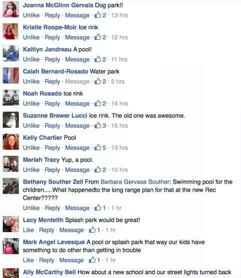
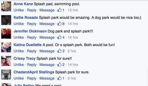
9 CHAPTER 5 Coordination and Consultation The environmental assessment will be released for a 30 day comment period during the month of April/May. All comments and responses will be available in the appendix of the final report. Additional public meetings regarding a review of the proposed site plan include RSU 39 Building Committee meetings, Caribou City council meetings, open public forums, and a straw poll. The Caribou recreation Department is developing a long range master plan for both properties. The following individuals or firms contributed to the development of the Environmental Assessment: Parties involved in the Environmental Assessment included: RSU 39, the City of Caribou, Caribou Recreation Center, Maine Historic Preservation Commission, PDT Architects, S.W. Cole Engineering, and Stantec (formerly FST). Public Involvement: Site Straw Poll: January 12th, 2016 RSU 39 Building Committee Meetings: The second Friday of every month beginning in May Caribou Recreation Department Facebook page comments (attached) Public Meeting: April 27 th, 2016 Figures: A: Location of Parkland in Caribou B: Existing 6f land and amenities C: Existing vs Proposed 6f boundary D: Proposed Park (Boundary A) 7

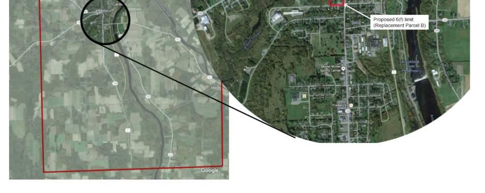
10 Figure A: Location in City 8
11 Figure B: Existing 6(f) boundary 9
")
")
12 Figure C: Existing 6(f) boundary and replacement 6(f) boundary 10
")
13 Figure D: Proposed Park (Boundary A) 11
14 Appendix: Phase 1 ESA (Separate Document) *Note: This Phase I ESA is only applicable to the Conversion site Teague Park and the Replacement Parcel A.* 12
15 Appendix: Correspondence with Maine Historic Preservation Commission
16 Appendix: Public Comments

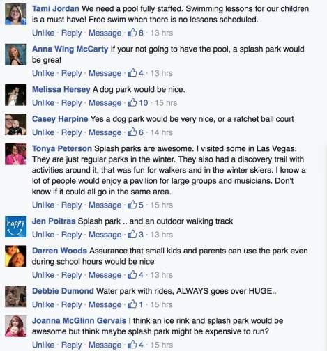
17 Facebook Comments:

18
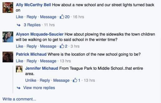
19
B. PREFERRED ALTERNATIVE: PROPOSED CONVERSION OF PARKLAND
 Chapter 2: Alternatives Considered A. INTRODUCTION The Brooklyn Bridge Park Corporation (BBPC), in cooperation with the City of New York, is proposing to convert approximately 2.65 acres of land that is
Community Development Committee
 C Date Prepared: Subject: Community Development Committee For the Metropolitan Council meeting of December 9, 2009 December 8, 2009 Committee Report SW Item: 2009-444 ADVISORY INFORMATION Rice Creek Chain
METROPOLITAN COUNCIL 390 North Robert Street, St. Paul, MN Phone (651) TDD (651)
 TDD (651)") METROPOLITAN COUNCIL 390 North Robert Street, St. Paul, MN 55101 Phone (651) 602-1000 TDD (651) 291-0904 DATE: November 23, 2009 TO: Metropolitan Parks and Open Space Commission FROM: Jan Youngquist, Senior
METROPOLITAN COUNCIL 390 North Robert Street, St. Paul, MN 55101 Phone (651) 602-1000 TDD (651) 291-0904 DATE: November 23, 2009 TO: Metropolitan Parks and Open Space Commission FROM: Jan Youngquist, Senior
CASE SUMMARY Conditional District Zoning Modification Planning Commission January 9, 2013 CD M1212
 CASE SUMMARY Conditional District Zoning Modification Planning Commission January 9, 2013 CD-3-109-M1212 Jim Diepenbrock, Associate Planner jim.diepenbrock@wilmingtonnc.gov 910-341-3257 Staff recommendation
Kingwood Service Association Overview
 Overview Kingwood Service Association (KSA) is a Texas non-profit corporation chartered September, 1976. Purpose Provide for community, civic, and social welfare in the Kingwood area and to promote the
Architect: Lucio Trabucco Nunes Trabucco Architects 109 Highland Avenue Needham, MA Tel: Fax:
 Boston Redevelopment Authority Article 80 Small Project Review Submittal for Proposed Retail/Residential Building 73 River Street Mattapan, Massachusetts Architect: Lucio Trabucco Nunes Trabucco Architects
PROPOSED FINDINGS OF FACT BENDER URBAN GROWTH BOUNDARY EXPANSION AND ANNEXATION REQUEST April 3, Background
 PROPOSED FINDINGS OF FACT BENDER URBAN GROWTH BOUNDARY EXPANSION AND ANNEXATION REQUEST April 3, 2016 Background The owners of TL300, 301, 302, 303, and 304, 3N1027BD - properties abutting the City Limits
CITY OF VACAVILLE PLANNING COMMISSION Agenda Item No. G.2 STAFF REPORT August 5, Staff Contact: Fred Buderi (707)
") CITY OF VACAVILLE PLANNING COMMISSION Agenda Item No. G.2 STAFF REPORT August 5, 2008 Staff Contact: Fred Buderi (707) 449-5307 TITLE: REQUEST: RECOMMENDED ACTION: OPPORTUNITY HOUSE EMERGENCY SHELTER RELOCATION
CITY OF VACAVILLE PLANNING COMMISSION Agenda Item No. G.2 STAFF REPORT August 5, 2008 Staff Contact: Fred Buderi (707) 449-5307 TITLE: REQUEST: RECOMMENDED ACTION: OPPORTUNITY HOUSE EMERGENCY SHELTER RELOCATION
Chapter Planned Residential Development Overlay
 Chapter 19.29 Planned Residential Development Overlay Sections 010 Purpose 020 Scope 030 Definitions 030 Minimum Size 040 Allowable Uses 050 Minimum Development Standards 060 Density Bonus 070 Open Space
Sandy Oakleaf Memorial Tennis Courts Background Information
 Sandy Oakleaf Memorial Tennis Courts Background Information The tennis courts located south of the JSH were built in 1990 as a memorial to Sandy Oakleaf, ACCHS student, who died in 1988. They were partially
SECTION I - INTRODUCTION
 - INTRODUCTION 1 2 - INTRODUCTIONION THE MASTER PLAN State law requires every community to have a Master Plan establishing an orderly guide to the use of lands in the community to protect public health
Bowie Marketplace Residential Detailed Site Plan Statement of Justification January 13, 2017 Revised February 2, 1017
 Bowie Marketplace Residential Detailed Site Plan Statement of Justification January 13, 2017 Revised February 2, 1017 Submitted on behalf of: BE Bowie LLC 5410 Edson Lane, Suite 220 Rockville, MD 20852
City of Cedar Hill Gated Community, Private Street Development Guide
 City of Cedar Hill Gated Community, Private Street Development Guide Definitions: Private Street - A private vehicular access way shared by and serving two or more lots, which is not dedicated to the public
Direct Control District No. 1 (DCD1) for The South Downtown
 for The South Downtown") Direct Control District No. 1 (DCD1) for The South Downtown Amended to September 13, 2010 13.1.3 Policies: 13.1.3.1 Linkage and Land Use a) Use of Land Uses for the DCD1 The only permitted uses in the
Direct Control District No. 1 (DCD1) for The South Downtown Amended to September 13, 2010 13.1.3 Policies: 13.1.3.1 Linkage and Land Use a) Use of Land Uses for the DCD1 The only permitted uses in the
Section 7.22: Multifamily Assisted Housing in AA-30 Residential Zone (MAHZ) [Note: an additional line will be added to the Table in Article 3, 3.1.
 [Note: an additional line will be added to the Table in Article 3, 3.1.") Section 7.22: Multifamily Assisted Housing in AA-30 Residential Zone (MAHZ) [Note: an additional line will be added to the Table in Article 3, 3.1.1A] 7.22.1 Purpose The purpose of this Special Regulation
Section 7.22: Multifamily Assisted Housing in AA-30 Residential Zone (MAHZ) [Note: an additional line will be added to the Table in Article 3, 3.1.1A] 7.22.1 Purpose The purpose of this Special Regulation
PLANNING COMMISSION STAFF REPORT
 PLANNING COMMISSION STAFF REPORT REZONING CASE: RZ-16-001 REPORT DATE: March 8, 2016 CASE NAME: Trailbreak Partners Rezoning PLANNING COMMISSION DATE: March 16, 2016 ADDRESSES OF REZONING PROPOSAL: 5501
City of Valdosta Land Development Regulations
 Chapter 206 Section 206-1 Base Zoning Districts Standards for Uses, Structures, and Property Development (B) (C) Principal Uses and Structures. Principal uses and structures permitted in each base zoning
7 Public Facilities. 7.1 Introduction. 7.2 Schools
 7 Public Facilities 7.1 Introduction Leroy Township, like many exurban and rural communities with a small population, does not have the same level of amenities as more densely populated urban and suburban
Hardwick State of the Town Forum & Charrette Summary
 Hardwick State of the Town Forum & Charrette Summary May 2014 Introduction The purpose of this report is to summarize the positions of approximately 50 residents of Hardwick provided at a State of the
DEPARTMENT OF COMMUNITY DEVELOPMENT SERVICES. Planning Division. m e m o r a n d u m
 DEPARTMENT OF UNITY DEVELOPMENT SERVICES Planning Division m e m o r a n d u m TO: FROM: The Urbana Zoning Board of Appeals Marcus Ricci, Planner II DATE: August 11, 2017 SUBJECT: ZBA Case 2017-C-01: a
content chapter Section 6(f) Land and Water Conservation Fund Areas 23.1 Summary of Key Legislation, Regulations, and Guidance 23.
 Land and Water Conservation Fund Areas 23.1 Summary of Key Legislation, Regulations, and Guidance 23.") chapter 23 Section 6(f) Land and Water Conservation Fund Areas content 23.1 Summary of Key Legislation, Regulations, and Guidance 23.2 Agency Roles 23.3 General Methodology for Evaluation 23.4 Format and
chapter 23 Section 6(f) Land and Water Conservation Fund Areas content 23.1 Summary of Key Legislation, Regulations, and Guidance 23.2 Agency Roles 23.3 General Methodology for Evaluation 23.4 Format and
PLANNED RESIDENTIAL DEVELOPMENT (PRD)
") PLANNED RESIDENTIAL DEVELOPMENT SECTION 10. PLANNED RESIDENTIAL DEVELOPMENT (PRD) 10.1 Purpose Planned Residential Development allows by special permit from the Board an alternative pattern of residential
PLANNED RESIDENTIAL DEVELOPMENT SECTION 10. PLANNED RESIDENTIAL DEVELOPMENT (PRD) 10.1 Purpose Planned Residential Development allows by special permit from the Board an alternative pattern of residential
Alternatives Considered A. INTRODUCTION
 Chapter 2: A. INTRODUCTION Alternatives Considered The Brooklyn Bridge Park Corporation (BBPC), in cooperation with the City of New York, is proposing to convert approximately 2.65 acres of land that is
RESOLUTION PC NOW THEREFORE, the Planning Commission of the City of Duarte resolves as follows:
 RESOLUTION PC 18-09 A RESOLUTION OF THE PLANNING COMMISSION OF THE CITY OF DUARTE APPROVING CONDITIONAL USE PERMIT 14-02, FOR THE USE AND OPERATION OF A WIRELESS COMMUNICATION FACILITY FOR VERIZON WIRELESS,
PROPOSED DEVELOPMENT: 2 & 50 SHEPPARD AVE. EAST, YONGE ST., 2-6 FOREST LANEWAY (YONGE-SHEPPARD CENTRE) TRUSTEE WARD 5
 TRUSTEE WARD 5") PUBLIC REPORT TO REGULAR BOARD PROPOSED DEVELOPMENT: 2 & 50 SHEPPARD AVE. EAST, 4841-4881 YONGE ST., 2-6 FOREST LANEWAY (YONGE-SHEPPARD CENTRE) TRUSTEE WARD 5 You need to persevere so that when you have
PUBLIC REPORT TO REGULAR BOARD PROPOSED DEVELOPMENT: 2 & 50 SHEPPARD AVE. EAST, 4841-4881 YONGE ST., 2-6 FOREST LANEWAY (YONGE-SHEPPARD CENTRE) TRUSTEE WARD 5 You need to persevere so that when you have
City of Grande Prairie Development Services Department
 City of Grande Prairie Development Services Department COUNTRYSIDE SOUTH OUTLINE PLAN Prepared by: GPEC Consulting Ltd. #202, 10712-100th Street Grande Prairie, AB Council Resolution of August 20, 2001
Paul D. Ralph, BES, RPP, MCIP, Commissioner, Development Services Department
 Public Report To: From: Report Number: Development Services Committee Paul D. Ralph, BES, RPP, MCIP, Commissioner, Development Services Department DS-16-50 Date of Report: April 14, 2016 Date of Meeting:
Village of Glenview Plan Commission
 Village of Glenview Plan Commission STAFF REPORT March 24, 2015 TO: Chairman and Plan Commissioners CASE #: P2015-012 FROM: Community Development Department CASE MANAGER: Michelle House, Planner SUBJECT:
Financial Impact Statement There are no immediate financial impacts associated with the adoption of this report.
 STAFF REPORT Planning and Development Department Subject: Application by RYC Property to rezone a portion of lands on John Murray Dr. and Megan Lynn Dr. from R2 to R3 and to enter into a Development Agreement
Napa County Planning Commission Board Agenda Letter
 Agenda Date: 2/7/2018 Agenda Placement: 8C Napa County Planning Commission Board Agenda Letter TO: FROM: Napa County Planning Commission Charlene Gallina for David Morrison - Director Planning, Building
Queen s Court Relocation Plan Tenant Landlord Commission January 10, Staff: Kim Painter, Laura London
 Tenant Landlord Commission January 10, 2018 Staff: Kim Painter, Laura London Queens Court Apartments 2 Queens Court Apartments Built 1941 Acquired by APAH in 1995 3 garden apt. buildings 39 units ALL one-bedroom
OPEN SPACE & RECREATION PLAN
 OPEN SPACE & RECREATION PLAN HOPEWELL TOWNSHIP Cumberland County, New Jersey Prepared by: Hopewell Township Environmental Commission Final October 2011 (THIS PAGE INTENTIONALLY LEFT BLANK) PUBLIC MEETINGS
Responsibilities of the Grant Recipient LAND AND WATER CONSERVATION FUND PROGRAM
 Responsibilities of the Grant Recipient LAND AND WATER CONSERVATION FUND PROGRAM STATE OF NEW HAMPSHIRE Department of Resources and Economic Development DIVISION of PARKS and RECREATION State of New Hampshire
Packet for New Home Construction
 Architectural Control Committee (ACC) Packet for New Home Construction As of: 1 February 2018 Questions, - email acc@elkinslake.net or Call 936-295-8181 or visit an ACC meeting Introduction and Welcome
Project Description Preferred Alternative
 DETERMINATION AND FINDINGS PURSUANT TO SECTION 204 OF EMINENT DOMAIN PROCEDURE LAW (EDPL) CITY OF SYRACUSE, PROEJCT SPONSOR CREEKWALK PHASE II JEFFERSON STREET TO COLVIN STREET PROJECT IDENTIFICATION NO.
CHAPTER 3 PERMITS, PLANS AND ANNEXATION
 CHAPTER 3 PERMITS, PLANS AND ANNEXATION SECTION: 10-3-1: General Regulations 10-3-2: Building Permit 10-3-3: Plans 10-3-4: Certificate of Compliance and Occupancy 10-3-5: Conditional Use Permits 10-3-6:
TOOELE COUNTY LAND USE ORDINANCE CHAPTER 31 Page 1
 CHAPTER 31 PLANNED COMMUNITY ZONE (P-C) Section 31-1 Definitions. 31-2 Purpose. 31-3 Land use districts. 31-4 P-C zone area minimum requirements. 31-5 Permitted uses. 31-6 Conditional uses. 31-7 Planning
O-I (Office-Institutional) and AG-1(Agricultural)
 and AG-1(Agricultural)") PROPERTY INFORMATION ADDRESS 3503 and 3505 Bethany Bend DISTRICT, LAND LOTS 2/1 973 and 974 OVERLAY DISTRICT State Route 9 PETITION NUMBERS EXISTING ZONING O-I (Office-Institutional) and AG-1(Agricultural)
PROPERTY INFORMATION ADDRESS 3503 and 3505 Bethany Bend DISTRICT, LAND LOTS 2/1 973 and 974 OVERLAY DISTRICT State Route 9 PETITION NUMBERS EXISTING ZONING O-I (Office-Institutional) and AG-1(Agricultural)
EXHIBIT 1 PROJECT DESCRIPTION AND DESCRIPTION OF REQUESTED AREA VARIANCES REDEVELOPMENT OF 201 ELLICOTT STREET
 EXHIBIT 1 PROJECT DESCRIPTION AND DESCRIPTION OF REQUESTED AREA VARIANCES REDEVELOPMENT OF 201 ELLICOTT STREET I. PROJECT DESCRIPTION: Ciminelli Real Estate Corporation (the Applicant ) is seeking area
DEVELOPMENT STANDARDS
 Chapter 5 DEVELOPMENT STANDARDS 501 Residential Development Standards 502 Neighborhood Commercial Standards 503 Mixed Use Standards 504 Industrial Development Standards 505 Public Use Standards 506 Open
1. Request amendment to Subarea C to allow multifamily use area
 Cantera Apartments at Riverview west Warrenville, IL 9 Apr 2018 Amendment request 1. Request amendment to Subarea C to allow multifamily use area Variances requested 1. Commercial center use a. Required
Truax Park Apartments
 Truax Park Apartments Master Planning and Site Development Study Prepared by The Community Development Authority of the City of Madison In association with SMITH & SMITH ASSOCIATES, Inc CONSTRUCTION COST
Spring Creek Village Stra/on Flats PUD Amendment. July 5, 2017 Gypsum Planning Commission July 11, 2017 Gypsum Town Council
 Spring Creek Village Stra/on Flats PUD Amendment July 5, 2017 Gypsum Planning Commission July 11, 2017 Gypsum Town Council PUD Sketch Plan PUD Sketch Plan PUD Sketch Plan Existing approved Stratton Flats
Our Focus: Your Future
 Town of Fort Erie Community & Development Services Our Focus: Your Future Prepared for Council-in-Committee Report No. CDS-064-07 Agenda Date August 13, 2007 File No. 350202 Subject LEASE AGREEMENT FOR
PLANNING RATIONALE REPORT
 PLANNING RATIONALE REPORT Zoning By-law Amendment Application 2920 Danbury Way Prepared for: Bravar Custom Builders Inc. and Village View Estates Ltd. by: 6393 Roslyn Street Ottawa (Orleans), Ontario K1C
POLK COUNTY DEVELOPMENT REVIEW COMMITTEE CASE OVERVIEW
 POLK COUNTY DEVELOPMENT REVIEW COMMITTEE CASE OVERVIEW DRC Date: January 10, 2019 Level of Review: 4 PC Date: March 6, 2019 Type: Text Amendments BoCC Date: May 7, 2019 July 2, 2019 Case Numbers: Case
Chair and Members Planning and Economic Development Committee
 TO: FROM: Chair and Members Planning and Economic Development Committee Melissa Halford Manager of Planning DATE: June 23, 2016 SUBJECT: Amendment No. 6 to Draft Approval Subdivision File No. S2006-3 (Loon
GWINNETT COUNTY CSO CONSERVATION SUBDIVISION OVERLAY DISTRICT REQUIREMENTS
 GWINNETT COUNTY CSO CONSERVATION SUBDIVISION OVERLAY DISTRICT REQUIREMENTS Section 1316. CSO Conservation Subdivision Overlay District. 1. Purposes. The purposes of this overlay district are as follows:
M E M O R A N D U M. Meeting Date: April 19, Item No. H-2. Mark Hafner, City Manager. Michele Berry, Planner II
 M E M O R A N D U M Meeting Date: April 19, 2016 Item No. H-2 To: From: Subject: Mark Hafner, City Manager Michele Berry, Planner II PUBLIC HEARING: Consider an ordinance approving a Specific Use Permit
ARTICLE 15 - PLANNED UNIT DEVELOPMENT
 Section 15.1 - Intent. ARTICLE 15 - PLANNED UNIT DEVELOPMENT A PUD, or Planned Unit Development, is not a District per se, but rather a set of standards that may be applied to a development type. The Planned
TOTTENHAM SECONDARY PLAN
 TOTTENHAM SECONDARY PLAN AMENDMENT NO. 11 TO THE OFFICIAL PLAN OF THE TOWN OF NEW TECUMSETH The following text and schedules to the Official Plan of the Town of New Tecumseth constitute Amendment No. 11
Back to Back and Stacked Townhouses
 Back to Back and Stacked Townhouses Draft Urban Design Guidelines & Proposed Zoning Regulations March 29, 2017 What have we done so far? September 19, 2016 Report to PDC summarizing positive and negative
6.5 LAND AND WATER CONSERVATION FUND ACT SECTION
 along the Trinity River Corridor are given the opportunity to review and comment upon them. The proposed project would be required to obtain a CDC from the floodplain/cdc administrators of Dallas and Irving.
Understanding the Conditional Use Process
 Understanding the Conditional Use Process The purpose of this document is to explain the process of applying for and obtaining a conditional use permit in the rural unincorporated towns of Dane County.
Belmead Neighbourhood Structure Plan
 Belmead Neighbourhood Structure Plan Office Consolidation November 2005 Prepared by: Planning and Policy Services Branch Planning and Development Department City of Edmonton Bylaw 6619 was adopted by Council
CITY OF SANTA ROSA COMMUNITY DEVELOPMENT DEPARTMENT STAFF REPORT FOR PLANNING COMMISSION SEPTEMBER 10, 2015 APPLICANT FILE NUMBER MJP
 ITEM NO. 9 CITY OF SANTA ROSA COMMUNITY DEVELOPMENT DEPARTMENT STAFF REPORT FOR PLANNING COMMISSION SEPTEMBER 10, 2015 PROJECT TITLE Yogurt Time Center ADDRESS/LOCATION 3093 Marlow Road ASSESSOR S PARCEL
DRAFT FOR PUBLIC HEARING (rev. March, 2016)
") Chapter 200. ZONING Article VI. Conservation/Cluster Subdivisions 200-45. Intent and Purpose These provisions are intended to: A. Guide the future growth and development of the community consistent with
Chapter 200. ZONING Article VI. Conservation/Cluster Subdivisions 200-45. Intent and Purpose These provisions are intended to: A. Guide the future growth and development of the community consistent with
TOWN OF WHITBY REPORT RECOMMENDATION REPORT
 TOWN OF WHITBY REPORT RECOMMENDATION REPORT REPORT TO: Planning and Development Committee REPORT NO: PL 4-08 DATE OF MEETING: January 21, 2008 FILE NO(S): MI-01-07 (SW- 2002-03) PREPARED BY: Planning Department
Urban Design Brief Dundas Street. London Affordable Housing Foundation. November Zelinka Priamo Ltd.
 Urban Design Brief 1039-1047 Dundas Street London Affordable Housing Foundation November 2017 Zelinka Priamo Ltd. TABLE OF CONTENTS Page No. INTRODUCTION... 3 SECTION 1 LAND USE PLANNING CONTEXT... 3 1.1
EXHIBIT D. Planned Unit Development Written Description April 13, 2016 Rouen Cove Phase II PUD
 1 EXHIBIT D Planned Unit Development Written Description April 13, 2016 Rouen Cove Phase II PUD Development # 8986.001 Developer: Curtis L. Hart Hart Resources LLC 8051 Tara Lane Jacksonville, Florida
NARRATIVE (GUIDELINES)
") NARRATIVE (GUIDELINES) SECTION I ACQUISITION (IF APPLICABLE, if not do not include) To be completed in narrative form by projects involving acquisitions in addition to Section II but is not required for
NARRATIVE (GUIDELINES) SECTION I ACQUISITION (IF APPLICABLE, if not do not include) To be completed in narrative form by projects involving acquisitions in addition to Section II but is not required for
Planned Unit Development (PUD). Sections:
. Sections:") Chapter 19.07. Planned Unit Development (PUD). Sections: 19.07.01. Purpose. 19.07.02. PUD Definition and Design Compatibility. 19.07.03. General PUD Standards. 19.07.04. Underlying Zones. 19.07.05. Permitted
Chapter 19.07. Planned Unit Development (PUD). Sections: 19.07.01. Purpose. 19.07.02. PUD Definition and Design Compatibility. 19.07.03. General PUD Standards. 19.07.04. Underlying Zones. 19.07.05. Permitted
RESIDENTIAL AND RECREATIONAL
 Energy, Mines & Resources Land Management Branch 320-300 Main Street Whitehorse, Yukon Y1A 2B5 667-5215 Fax 667-3214 www.emr.gov.yk.ca RESIDENTIAL AND RECREATIONAL Lot Enlargement Policy OBJECTIVE To facilitate
2.2 72ND STREET STATION ENTRANCE ALTERNATIVES
 Chapter 2: Entrance Alternatives 2.1 INTRODUCTION This chapter describes the alternatives that are evaluated in this Supplemental Environmental Assessment (EA) for the 72nd Street Station and 86th Street
The Maryland-National Capital Park and Planning Commission Prince George s County Planning Department Development Review Division
 The Maryland-National Capital Park and Planning Commission Prince George s County Planning Department Development Review Division 301-952-3530 Note: Staff reports can be accessed at www.mncppc.org/pgco/planning/plan.htm.
United States Post Office and Multi-Family Residential; and, Single- Family Residence with an Apartment
 Planning Commission File No.: AME2013 0009 January 9, 2014 Page 2 of 9 Existing Land Use: United States Post Office and Multi-Family Residential; and, Single- Family Residence with an Apartment Surrounding
CHAPTER 11 TOWN OF LISBON ZONING ORDINANCE
 SECTION 9 UC UPLAND CORRIDOR DISTRICT (a) (b) Purpose and Intent Upland Corridor District, as mapped or intended to be mapped, includes non-wetland/non-floodplain primary or secondary environmental corridors
Board of Zoning and Planning Members. Justin A. Milam, AICP, Planning Officer. Positive recommendation of a rezoning to City Council.
 To: From: Board of Zoning and Planning Members Justin A. Milam, AICP, Planning Officer Prepared for Meeting Dated: Tuesday, February 19, 2013 Subject: Action Requested: Master Plan Objective: BZAP review
Application Procedures for Easements or Rights of Way on City of Fort Collins Natural Areas and Conserved Lands March 2012
 Application Procedures for Easements or Rights of Way on City of Fort Collins Natural Areas and Conserved Lands March 2012 IMPORTANT NOTE: This document was created to accompany the City of Fort Collins
6.5 LAND AND WATER CONSERVATION FUND ACT SECTION
 6.3.7 Recommended Determination Findings for Public Parks and Recreational Areas A direct use of and temporary use of 2.5 acres of Elm Fork Greenbelt (750 square feet of actual ground space with the balance
Special Use Permit - Planned Unit Development Checklist. Property Address:
 Special Use Permit - Planned Unit Development Checklist Special Use Permit Number. Parcel Code/s #28-11- - - Property Address: Applicant: ARTICLE VIII Ordinance Reference - Section 8.1.2 Permit Procedures:
Neighborhood Parks and Residential Property Values in Greenville, South Carolina. Molly Espey Kwame Owusu-Edusei
 Neighborhood Parks and Residential Property Values in Greenville, South Carolina Molly Espey Kwame Owusu-Edusei Department of Agricultural and Applied Economics Clemson University January 2001 This research
3.1. OBJECTIVES FOR RESIDENTIAL LAND USE DESIGNATIONS GENERAL OBJECTIVES FOR ALL RESIDENTIAL DESIGNATIONS
 3. RESIDENTIAL LAND USE DESIGNATIONS INTRODUCTION The Residential land use designations provide for housing and other land uses that are integral to, and supportive of, a residential environment. Housing
Condominium Unit Requirements.
 ARTICLE 19 CONDOMINIUM REGULATIONS Section 19.01 Purpose. The purpose of this Article is to regulate projects that divide real property under a contractual arrangement known as a condominium. New and conversion
Questions and Answers about Neighborhood Conservation Districts
 Questions and Answers about Neighborhood Conservation Districts NEIGHBORHOOD CONSERVATION Planning Department Housing and Neighborhood Services NCD@townofchapelhill.org (919) 968-2728 Questions about Neighborhood
Architectural Control Committee (ACC) Packet for Miscellaneous Construction 1 February 2018
 Packet for Miscellaneous Construction 1 February 2018") Architectural Control Committee (ACC) Packet for Miscellaneous Construction 1 February 2018 Bulkheads, Remodeling, Fences, Roofing, Overhangs, Decks, Porches, Driveways, Walks Retaining Walls and other
Architectural Control Committee (ACC) Packet for Miscellaneous Construction 1 February 2018 Bulkheads, Remodeling, Fences, Roofing, Overhangs, Decks, Porches, Driveways, Walks Retaining Walls and other
Enclosed are amended PUD documents for The Grove at Shoal Creek Proposed by
 Enclosed are amended PUD documents for The Grove at Shoal Creek Proposed by The Bull Creek Road Coalition (BCRC) was formed in 2012 and is made up of residents in the six neighborhoods surrounding the
COMMUNITY PRESERVATION ACT Town of Hatfield OPEN SPACE PROJECT GUIDELINES
 COMMUNITY PRESERVATION ACT Town of Hatfield OPEN SPACE PROJECT GUIDELINES CPA Open Space Projects: The Act requires that a participating community shall spend, or set aside for later spending, not less
Marcel Williams, MPC Project Planner
 TO: FROM: The Planning Commission MPC Staff DATE: SUBJECT: Petition to Rezone Property Heath Shelton, Owner Jay Maupin, Agent 2026 Habersham Street Aldermanic District: 2, Bill Durrence County Commission
NOTICE OF MEETING. The City of Lake Elmo Planning Commission will conduct a meeting on Wednesday, November 14, 2012 at 7:00 p.m.
 3800 Laverne Avenue North Lake Elmo, MN 55042 (651) 777-5510 www.lakeelmo.org NOTICE OF MEETING The City of Lake Elmo Planning Commission will conduct a meeting on Wednesday, November 14, 2012 at 7:00
Plan Dutch Village Road
 Plan Dutch Village Road Objective: The lands around Dutch Village Road are a minor commercial area that services the larger Fairview community. Maintaining the vibrancy of the area by planning for redevelopment
City of Puyallup. Parks Impact Fee Study
 City of Puyallup Parks Impact Fee Study August 23, 2005 Prepared by Financial Consulting Solutions Group, Inc. 8201 164 th Avenue NE, Suite 300 Redmond, WA 98052 tel: (425) 867-1802 fax: (425) 867-1937
METROPOLITAN COUNCIL 390 North Robert Street, St. Paul, Minnesota Phone (651) TDD (651)
 TDD (651)") DATE: July 30, 2007 METROPOLITAN COUNCIL 390 North Robert Street, St. Paul, Minnesota 55101-1805 Phone (651) 602-1000 TDD (651) 291-0904 TO: Metropolitan Parks and Open Space Commission FROM: Arne Stefferud,
DATE: July 30, 2007 METROPOLITAN COUNCIL 390 North Robert Street, St. Paul, Minnesota 55101-1805 Phone (651) 602-1000 TDD (651) 291-0904 TO: Metropolitan Parks and Open Space Commission FROM: Arne Stefferud,
ARTICLE C. ZONING TEXT, DISTRICT CLASSIFICATIONS AND BOUNDARIES
 ARTICLE C. ZONING TEXT, DISTRICT CLASSIFICATIONS AND BOUNDARIES Sec. 10-2054. ZONING TEXT, DISTRICT CLASSIFICATIONS AND BOUNDARIES. In order to regulate the location of structures, the height and bulk
ARTICLE 13 CONDOMINIUM REGULATIONS
 ARTICLE 13 CONDOMINIUM REGULATIONS Section 13.01 Purpose. The purpose of this Article is to regulate projects that divide real property under a contractual arrangement known as a condominium. New and conversion
Leslie Street Official Plan Amendment Application Final Report
 STAFF REPORT ACTION REQUIRED 1075-1095 Leslie Street Official Plan Amendment Application Final Report Date: July 19, 2010 To: From: Wards: Reference Number: North York Community Council Director, Community
CONDOMINIUM REGULATIONS
 ARTICLE 37 CONDOMINIUM REGULATIONS SECTION 37.01. Purpose The purpose of this Article is to regulate projects that divide real property under a contractual arrangement known as a condominium. New and conversion
74af ANTELOPE VALLEY REDEVELOPMENT PLAN
 74af T. Telegraph District Phase 2: Telegraph Flats & Telegraph Lofts East 1. Project Area Description Phase 2 will include two building subphase areas with connecting streetscape enhancements: The Telegraph
NO: R172 COUNCIL DATE: SEPTEMBER 9, Locational Guidelines for Private Liquor Stores (Licensee Retail Stores)
") CORPORATE REPORT NO: R172 COUNCIL DATE: SEPTEMBER 9, 2013 REGULAR COUNCIL TO: Mayor & Council DATE: September 9, 2013 FROM: General Manager, Planning and Development FILE: 0340-01 SUBJECT: Locational Guidelines
CORPORATE REPORT NO: R172 COUNCIL DATE: SEPTEMBER 9, 2013 REGULAR COUNCIL TO: Mayor & Council DATE: September 9, 2013 FROM: General Manager, Planning and Development FILE: 0340-01 SUBJECT: Locational Guidelines
Liberty-Valley Elementary School
 150024 Liberty-Valley Elementary School Site Plan of Liberty-Valley Elementary Floor Plan of Liberty-Valley Elementary 2 150024; Liberty-Valley Elementary School. This school is located at 175 Liberty
CITY OF TYLER PLANNING AND ZONING COMMISSION STAFF COMMENTS
 CITY OF TYLER PLANNING AND ZONING COMMISSION STAFF COMMENTS Date: September 4, 2018 Subject: PD18-019 ZB3 PROPERTIES, LLC (2469 EARL CAMPBELL PARKWAY) Request that the Planning and Zoning Commission consider
Minutes of a Regular Meeting of the Development Review Board Held on the fifth day of December, 2018
 Minutes of a Regular Meeting of the Development Review Board Held on the fifth day of December, 2018 Members Present: Member(s) Absent: Others Present: Chairman Craig Powers, Vice Chair Orland Campbell,
3 and 5 Southvale Dr - Official Plan Amendment and Zoning Amendment Applications - Preliminary Report
 STAFF REPORT ACTION REQUIRED 3 and 5 Southvale Dr - Official Plan Amendment and Zoning Amendment Applications - Preliminary Report Date: August 20, 2015 To: From: Wards: Reference Number: North York Community
Environmental Assessment
 Environmental Assessment Conversion of Two Small Parcels of Wald Park with Replacement by Recreational Area at the Former Altadena Valley Country Club A conversion of land protected under Section 6(f)3
LAND USE INTRODUCTION EXISTING CONDITIONS
 INTRODUCTION This chapter describes land use in the Lemon Creek area using maps and data that show designations of all properties by the 2013 Comprehensive Plan, zoning code, and locations of developed
LILLIAN WEBB PARK DEVELOPMENT PROPOSAL. City of Norcross, Georgia 2034 Comprehensive Plan
 LILLIAN WEBB PARK DEVELOPMENT PROPOSAL City of Norcross, Georgia 2034 Comprehensive Plan AGENDA Overview: Zoning/Process: Market Studies: Design: Benefits: Bucky Johnson, Mayor John Bemis, DDA Chair Matt
Planning Justification Report
 Planning Justification Report, Township of Puslinch FARHI HOLDINGS CORPORATION Updated January 27, 2017 Zelinka Priamo Ltd. Page i TABLE OF CONTENTS Page No. 1.0 1.1 1.2 1.3 2.0 2.1 2.2 2.3 2.4 2.5 3.0
Staff Report. Street Vacation. Salt Lake City Planning Commission. Ashley Scarff, (801) or Date: April 10 th, 2019
 or Date: April 10 th, 2019") Staff Report PLANNING DIVISION DEPARTMENT of COMMUNITY & NEIGHBORHOODS To: From: Salt Lake City Planning Commission Ashley Scarff, (801) 535-7660 or ashley.scarff@slcgov.com Date: April 10 th, 2019 Re:
Staff Report PLANNING DIVISION DEPARTMENT of COMMUNITY & NEIGHBORHOODS To: From: Salt Lake City Planning Commission Ashley Scarff, (801) 535-7660 or ashley.scarff@slcgov.com Date: April 10 th, 2019 Re:
MIDWAY CITY Municipal Code
 MIDWAY CITY Municipal Code TITLE 9 ANNEXATION CHAPTER 9.01 PURPOSE CHAPTER 9.02 GENERAL REQUIREMENTS CHAPTER 9.03 PROPERTY OWNER INITIATION OF ANNEXATION CHAPTER 9.04 PROCEDURES FOR CONSIDERATION OF PETITION
R E S O L U T I O N. B. Development Data Summary
 R E S O L U T I O N WHEREAS, the Prince George s County Planning Board has reviewed DPLS-333 requesting a Departure from Parking and Loading Standards for 19 parking spaces in accordance with Subtitle