Foreclosure /- Acres in Loudoun County, Purcellville, VA
|
|
|
- Angelica Moore
- 5 years ago
- Views:
Transcription


1 Foreclosure /- Acres in Loudoun County, Purcellville, VA Preview: November 19 & December 3, 11am - 1pm ET Auction: December 10, 11am ET Auction Location: Loudoun County Circuit, 18 E Market St Leesburg, VA Property#: FX1749 David Lowry, Tranzon Fox 121 Pennsylvania Ave Virginia Beach, VA P: F: dlowry@tranzon.com TRANZON.COM
2 Table of Contents Click the links below to go directly to its corresponding section 1. Attention Prospective Bidders 2. Property/Auction Overview 3. Photo Gallery 4. Appraisal Excerpts 5. Zoning Information 6. Legal Notice 7. Broker Acknowledgement Form

3 ATTENTION PROSPECTIVE BIDDERS ALL INFORMATION CONTAINED IN THIS AND ANY OTHER MARKETING MATERIALS WAS OBTAINED FROM SOURCES BELIEVED TO BE ACCURATE. HOWEVER, NO WARRANTY OR GUARANTEE, EITHER EXPRESS OR IMPLIED, IS INTENDED OR MADE WITH RESPECT TO SUCH INFORMATION. BIDDERS MUST INDEPENDENTLY INVESTIGATE, VERIFY AND CONFIRM ANY INFORMATION OR ASSUMPTIONS ON WHICH ANY BID IS BASED. NEITHER AUCTION COMPANY, NOTEHOLDER, NOR SELLERS SHALL BE LIABLE FOR ANY ERRORS IN OR THE CORRECTNESS OF ANY INFORMATION REGARDING THE PROPERTY BEING SOLD. THE PROPERTY SHALL BE SOLD PURSUANT TO AND AS DESCRIBED IN THE ATTACHED NOTICE OF SUBSTITUTE TRUSTEES SALE. TO THE EXTENT OF ANY INCONSISTENCY BETWEEN THE INFORMATION CONTAINED IN THIS PACKAGE AND THE ATTACHED NOTICE, THE ATTACHED NOTICE SHALL CONTROL. TO THE EXTENT OF ANY INCONSISTENCY BETWEEN ANNOUNCEMENTS MADE AT THE SALE AND ANY OTHER PROPERTY INFORMATION OR PRINTED TERMS OF SALE, THE SALE ANNOUNCEMENTS SHALL CONTROL. THE PROPERTY IS SOLD AS IS, WHERE IS, WITH ALL FAULTS. THE PROPERTY WILL BE SOLD WITHOUT REPRESENTATION OR WARRANTY OF ANY KIND, INCLUDING ANY REPRESENTATIONS REGARDING ENVIRONMENTAL CONDITIONS AFFECTING THE PROPERTY. THE PROPERTY IS OFFERED FOR SALE TO QUALIFIED PURCHASERS WITHOUT REGARD TO RACE, COLOR, RELIGION, SEX, MARITAL STATUS OR NATIONAL ORGIN. ANY DECISION TO PURCHASE OR NOT TO PURCHASE IS THE SOLE AND INDEPENDENT BUSINESS DECISION OF THE PURCHASER. NO RECOURSE OR CAUSE OF ACTION WILL LIE AGAINST THE SELLERS, THE AUCTION COMPANY OR THE NOTEHOLDER SHOULD PURCHASER BECOME DISSATISFIED WITH ITS DECISION, WHATEVER IT MAY BE, AT A LATER DATE.

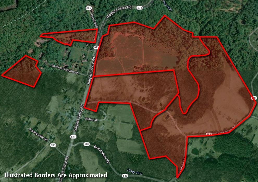
 non-contiguous parcels of land containing a total of 166.49+/- acres.")
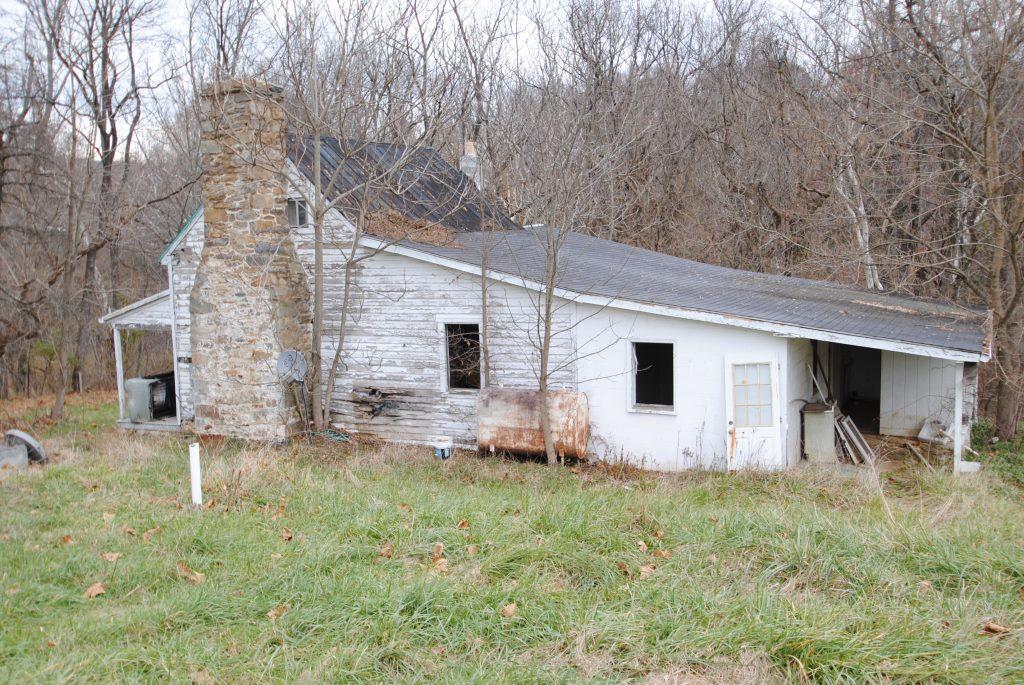
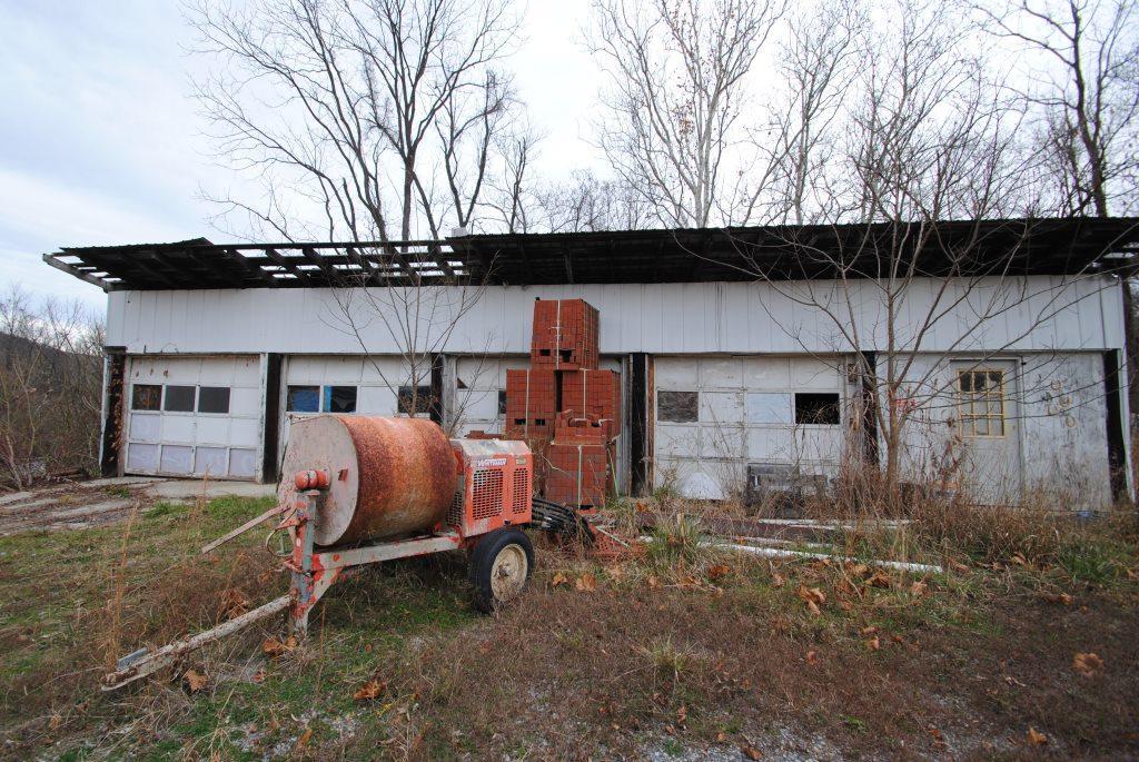
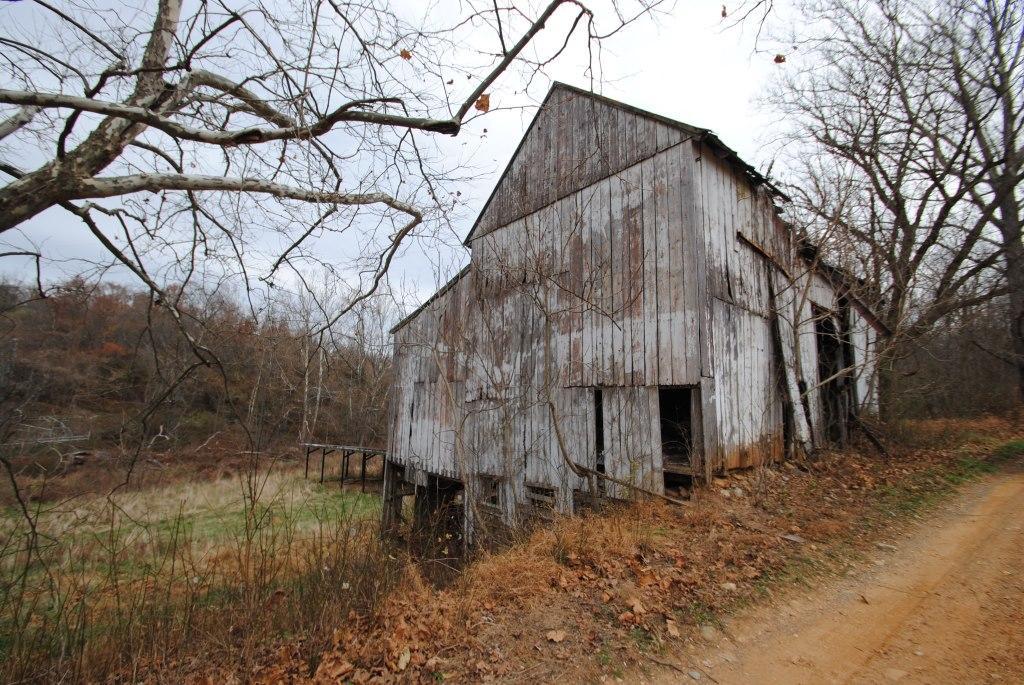
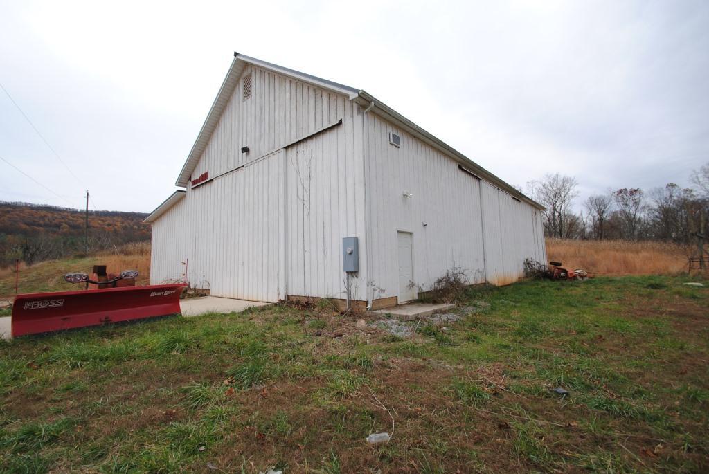
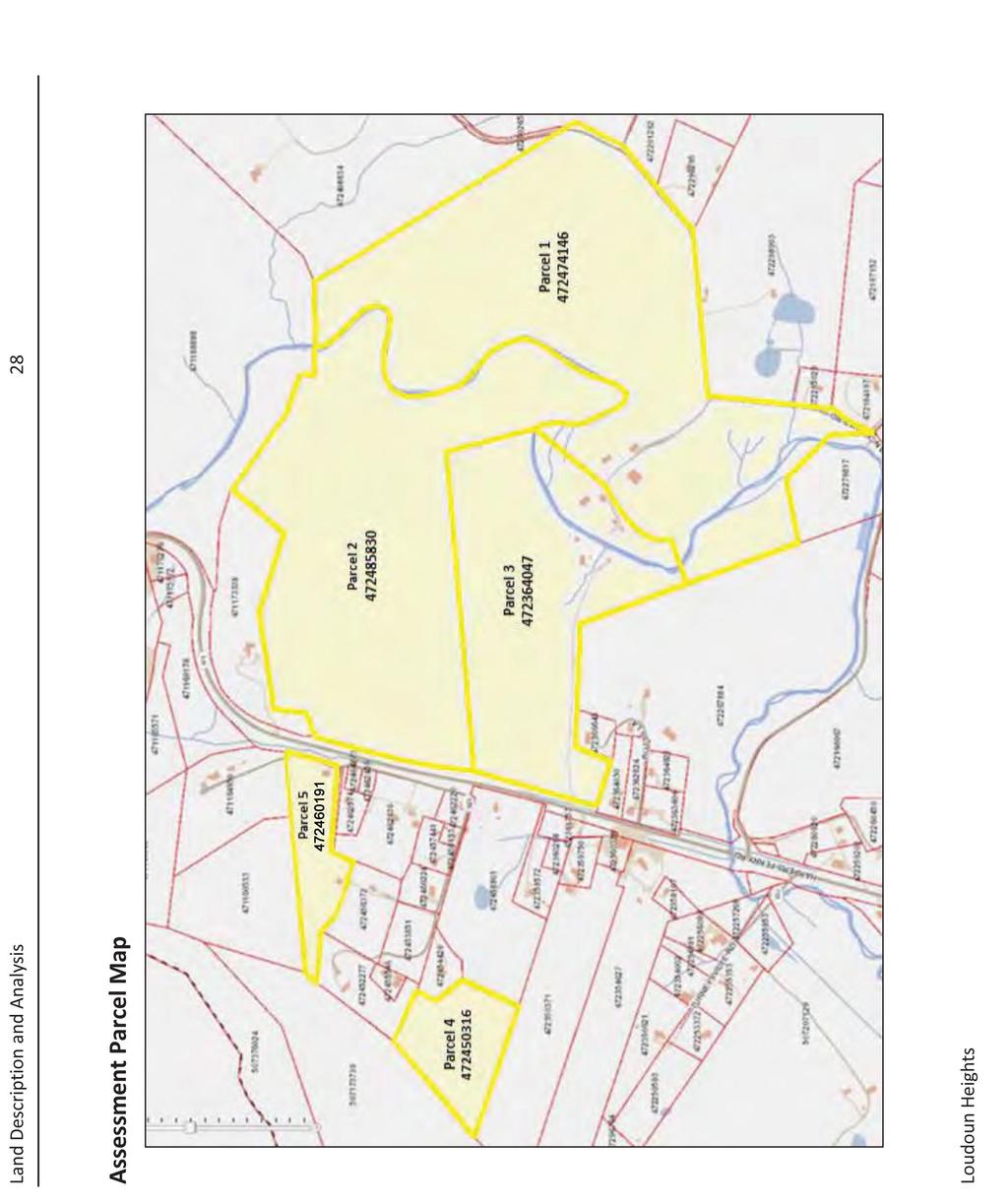
4 Foreclosure /- Acres in Loudoun County, Purcellville, VA Property #: FX1749 Auction Date and Time: Wednesday, December 10, 11:00am Property Preview Date and Time: Wed, November 19, 11:00am - 1:00pm Wed, December 3, 11:00am - 1:00pm Property Location: Primary Street Frontage, Harpers Ferry Rd Purcellville, VA Auction Location: Loudoun County Circuit 18 E Market St, Leesburg, VA Property Description: The Property is believed to consist of five (5) non-contiguous parcels of land containing a total of /- acres. Three (3) of the parcels are believed to contain single-family residences and several agricultural buildings. The property is located on both the east and west sides of Harpers Ferry Road, just south of the Virginia/Maryland border. The property is zoned AR-1, Agricultural Rural-1, which permits rural economy uses, with residential uses allowed. Property will be offered as separate parcels and as an entirety at auction. Parcel ID Tax ID Number Size Zoning "By Right Lots" Parcel AR-1 13 Parcel AR-1 11 Parcel AR-1 6 Parcel AR-1 1 Parcel AR-1 1 Totals Parcel One, Tax ID , /- AC Parcel 4146, contains /- acres and is believed to have an address of Branchriver Road, Purcellville, VA This parcel is also believed to contain a single story wood structure containing approximately 1,472 square feet. This property is also believed to contain several large agricultural buildings. Parcel Two, Tax ID , /- AC Parcel 5830, contains /- acres.

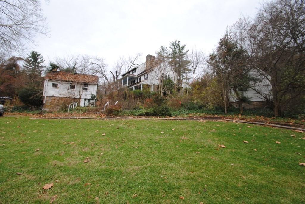
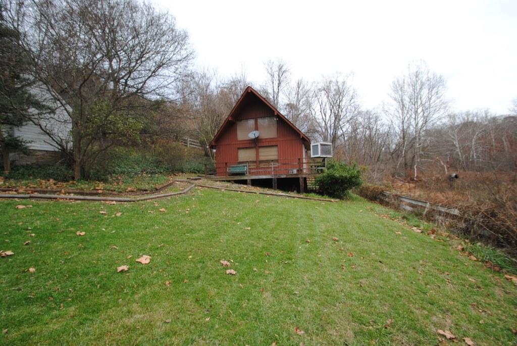
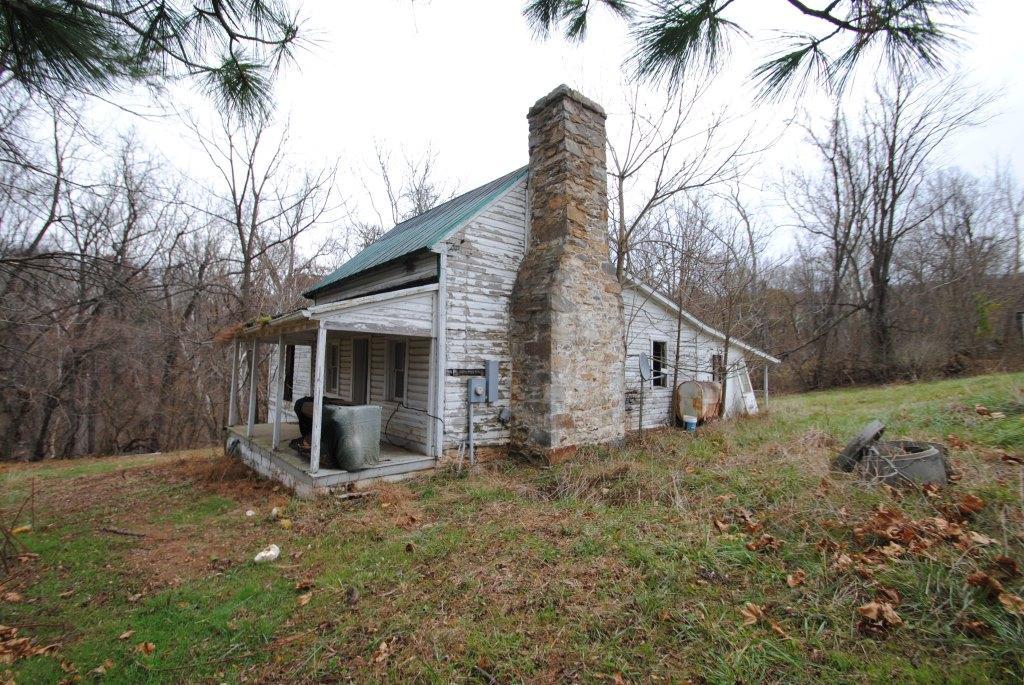
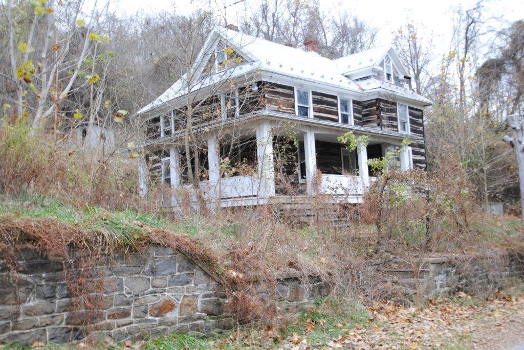
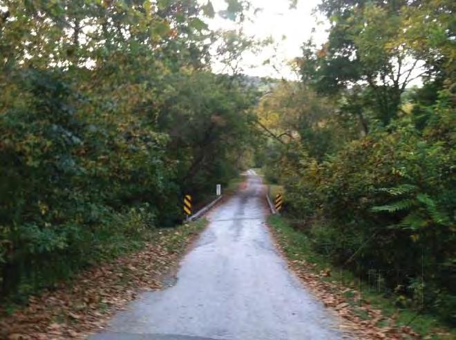
5 Parcel Three, Tax ID , /- AC Parcel 4047, contains /- acres and is believed to have an address of Harpers Ferry Road, Purcellville, VA This parcel is also believed to contain a 2-story wood structure that is reported to be built in 1790 and contains approximately 2,057 square feet. Parcel Four, Tax ID , 6.50+/- AC Parcel 0316, contains /- acres. Parcel Five, Tax ID , 5.63+/- AC Parcel 0191, contains /- acres and is believed to have an address of Riverheights Road, Purcellville, VA This parcel is also believed to contain a 2-story log cabin with approximately 1,579 square feet. Area Overview and Access The property is well located within the Loudoun County market, which includes the municipalities of Leesburg, Purcellville, Lovettsville, and Round Hill. The major arterial road in Purcellville is Harry Byrd Highway / East Market Street (Route 7), which crosses the area in an east-west direction. Access to the properties is provided by Harpers Ferry Road (Route 671). The parcels are located in close proximity to Virginia, Maryland, and the West Virginia border. Access from Maryland and West Virginia is provided by Route 340, which runs along the border to the North. Access to the property is provided by River Heights Road, Turneysville Road, and Branchriver Road. Utilities Water Private Well Sewer Private Septic Electricity Dominion Power Natural Gas Washington Gas Local Phone Verizon Directions: From Leesburg, VA; Merge onto VA-7 W/Harry Byrd Hwy via the ramp to Winchester/VA-9; Take the VA-9 exit toward Hillsboro/Charles Town W VA; Turn right onto VA-9 W/Charles Town Pike; Slight right onto State Rte 671/Harpers Ferry Rd Destination will be on the right; Arrive Harpers Ferry Rd, Purcellville, VA Cooperating Broker s Fee: 1% of the high bid will be paid to a properly registered broker at settlement. Summary of Terms of Sale: All property sold in as is condition. A 3% buyer s premium will be added to the high bid to determine the contract price. Please see the Legal Notice in this information package for the complete terms of sale. David Lowry Tranzon Fox dlowry@tranzon.com VAAF423


6 Photo Gallery

7 Photo Gallery
8 Appraisal Excerpts

9 Picture of Potomac River taken from adjacent site and not reflective of view from subject Loudoun Heights Turneysville Road Purcellville, Virginia
10 Summary of Salient Facts and Conclusions 1 Summary of Salient Facts and Conclusions Property Name Address Property Type Owner of Record Tax ID Land Area acres; 7,252,304 SF Zoning Designation AR-1, Agricultural Rural-1 Highest and Best Use Hold for development Exposure Time; Marketing Period 12 months; 12 months Effective Date of the Appraisal October 4, 2013 Date of the Report October 15, 2013 Property Interest Appraised Fee Simple Loudoun Heights Turneysville Road Purcellville, Loudoun County, Virginia Land Loudoun Heights, LLC , , , , and Sales Comparison Approach Number of Sales 6 Range of Sale Dates Jun 11 to Jun 13 Range of Prices per Acre (Unadjusted) $8,615 - $13,690 Market Value Conclusion $2,000,000 ($12,013/Acre) The values reported above are subject to the definitions, assumptions, and limiting conditions set forth in the accompanying report of which this summary is a part. No party other than M&T Bank may use or rely on the information, opinions, and conclusions contained in the report. The summary shown above is for the convenience of M&T Bank, and therefore it is assumed that the users of the report have read the entire report, including all of the definitions, assumptions, and limiting conditions contained therein. Extraordinary Assumptions and Hypothetical Conditions The value conclusions are subject to the following extraordinary assumptions that may affect the assignment results. An extraordinary assumption is uncertain information accepted as fact. If the assumption is found to be false as of the effective date of the appraisal, we reserve the right to modify our value conclusions. 1. According to the Loudoun County Treasurer's Office, the subject s real estate taxes for 2012 and the first half of 2013 are delinquent. Overall, the total outstanding taxes, late penalties, and interest charges currently owed amount to $40,465 (rounded). This total amount owed is effective through October 31, 2013, when additional interest will be added if not paid in full. We note that after 3 years of delinquent taxes, the property will become eligible for tax sale. Back taxes are generally a lien on the property and are not transferrable to a new owner. Our valuation assumes that the current outstanding real estate taxes, late penalties, and interest charges will be paid prior to any market transaction and have not been deducted from our final opinion of market value. These outstanding charges are discussed in detail in our real estate tax analysis. Loudoun Heights
11
12 Loudoun County Area Analysis 6 Economic Analysis Loudoun County Area Analysis Loudoun County is located in northern Virginia approximately 20 miles west of Washington, DC. It is 516 square miles in size and has a population density of 658 persons per square mile. Loudoun County is part of the Washington-Arlington-Alexandria, DC-VA-MD-WV Metropolitan Statistical Area, hereinafter called the Washington MSA, as defined by the U.S. Office of Management and Budget. Population Loudoun County has an estimated 2013 population of 339,337, which represents an average annual 2.8% increase over the 2010 census of 312,311. Loudoun County added an average of 9,009 residents per year over the period, and its annual growth rate exceeded the Washington MSA rate of 1.5%. Looking forward, Loudoun County's population is projected to increase at a 2.1% annual rate from , equivalent to the addition of an average of 7,534 residents per year. Loudoun County's growth rate is expected to exceed that of the Washington MSA, which is projected to be 1.3%. Employment Trends in employment are a key indicator of economic health and strongly correlate with real estate demand. Total employment in Loudoun County is currently estimated at 144,197 jobs. Between yearend 2002 and the present, employment rose by 42,128 jobs, equivalent to a 41.3% increase over the entire period. There were gains in employment in nine out of the past ten years despite two national economic downturns during this time. Job growth in Loudoun County turned positive in 2010 and has remained so. Loudoun County's rate of employment growth over the last decade surpassed that of the Washington MSA, which experienced an increase in employment of 9.2% or 248,577 jobs over this period. Employment data is shown in the table that follows. Loudoun Heights
13 Loudoun County Area Analysis 7 Unemployment rate trends are another way of gauging an area s economic health. Over the past decade, the Loudoun County unemployment rate has been consistently lower than that of the Washington MSA, with an average unemployment rate of 3.3% in comparison to a 4.4% rate for the Washington MSA. This is another indication of the strength of the Loudoun County economy over the longer term. Recent data shows that the Loudoun County unemployment rate is 4.4% in comparison to a 5.7% rate for the Washington MSA, a positive sign that is consistent with the fact that Loudoun County has outperformed the Washington MSA in the rate of job growth over the past two years. Major employers in Loudoun County are shown in the following table. Loudoun Heights
14 Loudoun County Area Analysis 8 Gross Domestic Product Gross Domestic Product (GDP) is a measure of economic activity based on the total value of goods and services produced in a defined geographic area. Although GDP figures are not available at the county level, data reported for the Washington MSA is considered meaningful when compared to the nation overall, as Loudoun County is part of the MSA and subject to its influence. Economic growth, as measured by annual changes in GDP, has been considerably higher in the Washington MSA than the United States overall during the past eight years. The Washington MSA has grown at a 2.0% average annual rate while the United States has grown at a 1.0% rate. As the national economy recovers from the downturn of , the Washington MSA has recently underperformed the United States. GDP for the Washington MSA rose by 1.1% in 2011 while the United States GDP rose by 1.5%. The Washington MSA has a per capita GDP of $66,746, which is 59% greater than the United States GDP of $42,070. This means that Washington MSA industries and employers are adding relatively more value to the economy than their counterparts in the United States overall. The figures in the table above represent inflation adjusted real GDP stated in 2005 dollars. Income, Education, and Age Loudoun County is more affluent than the Washington MSA. Median household income for Loudoun County is $119,584, which is 37.0% greater than the corresponding figure for the Washington MSA. Loudoun Heights

15 Loudoun County Area Analysis 9 Residents of Loudoun County have a higher level of educational attainment than those of the Washington MSA. An estimated 58% of Loudoun County residents are college graduates with fouryear degrees, versus 47% of Washington MSA residents. People in Loudoun County are slightly younger than their Washington MSA counterparts. The median age for Loudoun County is 36 years, while the median age for the Washington MSA is 37 years. Education & Age Percent College Graduate Median Age 80% 70% 60% 50% 40% 30% 20% 10% 58% Loudoun County 47% Washington, DC MSA Loudoun County Washington, DC MSA Source: Claritas Conclusion The national economic downturn of had less of an impact on Loudoun County than on many areas of the country. Over the long term, Loudoun County will benefit from a growing population base and higher income and education levels. Loudoun County experienced growth in the number of jobs and has maintained a consistently lower unemployment rate than the Washington MSA over the past decade. Moreover, Loudoun County benefits from being part of the Washington MSA, which is the seventh most populous metropolitan area in the country, and exhibits both a higher rate of GDP growth and a higher level of GDP per capita than the nation overall. Based on these factors, we anticipate that the Loudoun County economy and employment base will grow, strengthening the demand for real estate. Loudoun Heights


16 Loudoun County Area Analysis 10 Area Maps Loudoun Heights
17 Surrounding Area Analysis 11 Surrounding Area Analysis Location The subject is located in the northern most part of Loudoun County, VA. During the past 15 years, Loudoun County has grown tremendously. This growth has included abundant residential subdivision and retail shopping center developments. Areas within Loudoun County such as Leesburg, Middleburg, and the Town of Purcellville have vibrant central business districts as a result of this growth. In addition, these areas benefit from tourism drawn to the area by historical attractions and local wineries. The subject s immediate area is known as Loudoun Heights. While Loudoun Heights contains a Purcellville zip code, the area is more rural in nature than the Town of Purcellville and located approximately 15 miles to the north. Access and Linkages The major arterial road in Purcellville is Harry Byrd Highway / East Market Street (Route 7), which crosses the area in an east-west direction. Access to the subject is provided by Harpers Ferry Road (Route 671). The subject is located in close proximity to the junction of the Virginia, Maryland, and West Virginia borders. Access from Maryland and West Virginia is provided by Route 340, which runs along the Virginia border to the north. Access to the subject parcels is provided by Riverheights Road, Turneysville Road, and Branchriver Road. Overall, vehicular access is good. Public transportation, consisting of commuter bus services, is provided by Loudoun County Transit. This bus service provides daily service to the West Falls Church, Washington Metropolitan Area Transit Authority s Metrorail subway station. The nearest bus access point is the Purcellville Connector around 15 miles south of the subject. The local market perceives public transportation as fair compared to other areas in the region. As mentioned, Loudoun Heights is more rural in nature and does not benefit from higher average daily traffic counts (3,200 vehicles per day in 2012 along Harpers Ferry Road). Other towns in Loudoun County benefit from higher traffic counts and foot traffic than Loudoun Heights. Leesburg averages 13,111 vehicles per day along Market Street, and Middleburg averages 12,231 vehicles per day along John Mosby Highway. Demand Generators Loudoun County has become one of the nation s leading destinations for technology companies including Orbital Sciences, Verizon Business, AOL, and NeuStar. Ashburn in particular is part of the Dulles Technology Corridor. The Dulles Corridor has become an international leader in research, technological, and development oriented companies, with more than 575,000 jobs and 30,000 business establishments, of which more than 125 are internationally affiliated. Major employment nodes are located in the areas surrounding the Route 28 corridor, the Route 7 corridor, and the Washington Dulles Airport. Purcellville is approximately 30 miles west of these primary employment nodes. Other towns throughout Loudoun County are located closer to most employment centers than Purcellville and offer stronger infrastructure and supporting services Loudoun Heights
18 Surrounding Area Analysis 12 Demographics A demographic profile of the surrounding area, including population, households, and income data, is presented in the following table. Surrounding Area Demographics 2013 Estimates 1-Mile Radius 3-Mile Radius 5-Mile Radius Loudoun County Washington, DC MSA Population ,561 15, ,311 5,582,170 Population ,555 16, ,337 5,828,935 Population ,543 16, ,005 6,214,887 Compound % Change % 0.0% 0.7% 2.8% 1.5% Compound % Change % -0.1% 0.6% 2.1% 1.3% Households ,826 5, ,583 2,074,730 Households ,826 6, ,568 2,167,514 Households ,821 6, ,354 2,316,855 Compound % Change % 0.0% 0.8% 2.5% 1.5% Compound % Change % -0.1% 0.6% 2.0% 1.3% Median Household Income 2013 $80,011 $66,310 $72,592 $119,584 $87,308 Average Household Size College Graduate % 35% 30% 30% 58% 47% Median Age Owner Occupied % 84% 79% 81% 78% 64% Renter Occupied % 16% 21% 19% 22% 36% Median Owner Occupied Housing Value $260,584 $218,896 $228,496 $367,491 $337,411 Median Year Structure Built Avg. Travel Time to Work in Min Source: Claritas As shown above, the current population within a 3-mile radius of the subject is 4,555, and the average household size is 2.5. Population in the area has been flat since the 2010 census, but the trend is projected to change to decline over the next five years. This is in contrast to the population of Loudoun County, which is projected to grow, as discussed previously. Median household income is $66,310, which is lower than the household income for Loudoun County. Residents within a 3-mile radius have a considerably lower level of educational attainment than those of Loudoun County, while median owner occupied home values are considerably lower. Development Activity and Trends The Dulles Corridor Rapid Transit Project has received State and Federal funding and construction on the initial phase is on-going. This project will expand the current Metrorail system from the Orange Line (between the East and West Falls Church Stations) in Fairfax County, through Tyson s Corner and the Dulles International Airport, into Loudoun County. Phase 1 of the Project, officially known as the Dulles Corridor Metrorail Project - Extension to Wiehle Avenue, will complete the first 11.6 miles of the planned extension from the Metrorail Orange Line to Wiehle Avenue in Reston. It will include five new stations: Tyson s East, Tyson s Central 123, Tyson s Central 7, Tyson s West, and Wiehle Avenue, plus improvements to the existing rail yard at the West Falls Church Station. According to the June 2013 edition of the Dulles Metro Newsletter, construction Loudoun Heights

19 Surrounding Area Analysis 13 of the new line is around 94% complete and on track for a September 2013 delivery. The Washington Metropolitan Area Transit Authority anticipates a late December 2013 opening. Phase 2 of the Project, from Wiehle Avenue to Route 772/Ryan Road in Loudoun County, will include six additional stations: Reston Parkway, Herndon-Monroe, Route 28, Dulles Airport, Route 606, and Route 772, plus a new rail yard on the Dulles Airport property. The preliminary engineering is currently underway for Phase 2. According to the Metropolitan Washington Airports Authority, this phase is scheduled to open in A map of the proposed stations in the Dulles Corridor Metrorail Project, as provided by the Virginia Department of Transportation, is below. The Washington Dulles International Airport is located about 20 miles southeast of the subject. The Washington, DC CBD, the economic and cultural center of the region, is approximately 40 miles east of the property. Within close proximity of the subject, most development has consisted of single-family residential communities. The Harpers Ferry area has seen a significant influx in recent residential development within the past 10 years. Loudoun Heights
20 Surrounding Area Analysis 14 Land Use The area is semi-rural in character and approximately 30% developed. Predominant land uses are residential and agricultural. Other land use characteristics are summarized below. Character of Area Predominant Age of Improvements Predominant Quality and Condition SURROUNDING AREA LAND USES Small town/rural Approximate Percent Developed 30% Infrastructure/Planning Prospective Change in Land Use Prevailing Direction of Growth Many buildings in the Loudoun Heights area were constructed in the 1900s. Nearby subdivisions have been developed over the past 15 years. Fair to Average Average Not likely Northwest North South East West Subject s Immediate Surroundings Rural Residential Rural Residential Rural Residential Harpers Ferry National Historical Park Outlook and Conclusions Loudoun County has experienced growth in population and employment over the past decade. The Loudoun Heights area, like Leesburg, Middleburg, and the Town of Purcellville, has benefitted from this growth, as well as from the tourism industry. However, Loudoun Heights has roughly one-fifth the traffic flow of these other towns, significantly less infrastructure to attract tourism, and less supporting services. Loudoun Heights has benefitted from the success of Loudoun County, but less so than nearby towns. Given the history of the area and the growth trends, it is anticipated that in the medium to long term property values will increase. However, due to the current soft market conditions, we anticipate that property values will remain stable in the near future before increasing in the long term. Loudoun Heights

21 Surrounding Area Analysis 15 Surrounding Area Map Loudoun Heights
22 Land Description and Analysis 22 Property Analysis Land Description and Analysis Land Description Land Area acres; 7,252,304 SF Source of Land Area Loudoun County Public Records Primary Street Frontage Harpers Ferry Road Shape Multiple irregular shaped lots. Topography Parcels to the west of Harpers Ferry Road contain steep upward slopes to the west. Parcels to the east of Harpers Ferry Road are generally rolling with steep slopes in portions of the property. Drainage No problems reported or observed. Environmental Hazards None reported or observed. Ground Stability No problems reported or observed. Flood Area Panel Number 51107C0025D Date July 5, 2001 Zone X Description Outside of 500-year floodplain Insurance Required? No Zoning; Other Regulations Zoning Jurisdiction Loudoun County Zoning Designation AR-1 Description Agricultural Rural-1 Legally Conforming? Yes Zoning Change Likely? Not likely Permitted Uses Rural economy and residential uses. Utilities Water Private Well Sewer Private Septic Electricity Dominion Power Natural Gas Washington Gas Local Phone Verizon The minimum lot area within the AR-1 zoning district permits one dwelling per 20 acres, which can be reduced to five acres per dwelling under the Cluster Subdivision Option. Loudoun Heights
23

 Rolling Open Area 2013)")
")
 Loudoun")
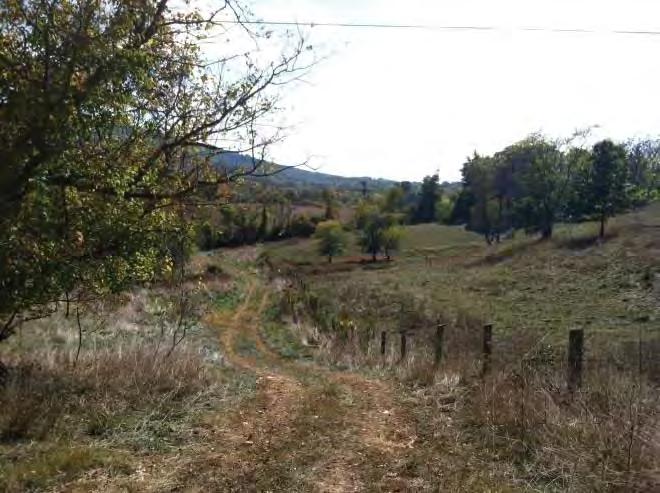

24 Land Description and Analysis 24 Property Entrance From Road (Photo Taken on October 4, 2013) Rolling Open Area (Photo Taken on October 4, 2013) Interior Access Way (Photo Taken on October 4, 2013) Entrance Through Creek (Photo Taken on October 4, 2013) Rolling Land (Photo Taken on October 4, 2013) Open Rolling Land (Photo Taken on October 4, 2013) Loudoun Heights


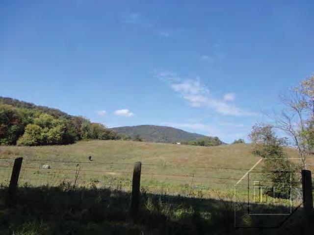
25 Land Description and Analysis 25 Creek Through Site (Photo Taken on October 4, 2013) Rolling Open Land (Photo Taken on October 4, 2013) Wooded Area (Photo Taken on October 4, 2013) Additional Site Entrance (Photo Taken on October 4, 2013) Rolling Open Land (Photo Taken on October 4, 2013) Wooded Area (Photo Taken on October 4, 2013) Loudoun Heights


")


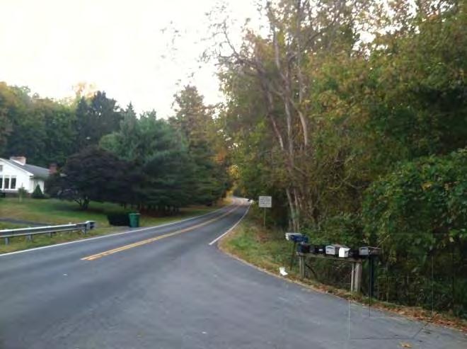
26 Land Description and Analysis 26 Rolling Wooded Area (Photo Taken on October 4, 2013) Lower Elevation Overgrown Area (Photo Taken on October 4, 2013) Steeper Grade Area (Photo Taken on October 4, 2013) Overall View of Site From Adjacent Land (Photo Taken on October 4, 2013) Southern View of Harpers Ferry Road (Photo Taken on October 4, 2013) Northern View of Harpers Ferry Road (Photo Taken on October 4, 2013) Loudoun Heights

27 Land Description and Analysis 27 Site Plan Loudoun Heights
28
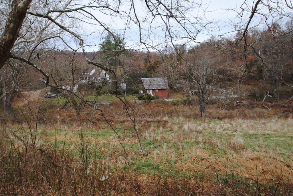
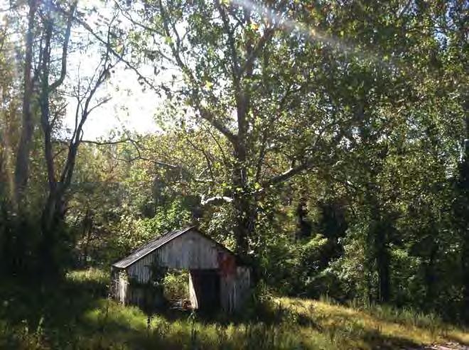
29 Improvements Description and Analysis 29 Improvements Description and Analysis The subject currently consists of five parcels totaling acres of raw land. Overall the parcels include three single-family residences and several agricultural buildings. The property by-right under the Cluster Subdivision Option is available to be developed with up to 32 detached single-family dwellings with a typical lot size of 5 acres. The property is located on both the east and west sides of Harpers Ferry Road, just south of the Virginia/Maryland border. The following description is based on our on-site inspection of the property and past discussions with Mr. Joe Bane, a representative of the property owner, along with public records. The residential dwelling located on Parcel 2 with the address of Riverheights Road is a 2-story log cabin with approximately 1,579 square feet of gross living area. The property appears to be in poor condition, and is not occupied. The residential dwelling located on Parcel 3 with the address of Harpers Ferry Road is a 2- story wood structure reported built in 1790, containing approximately 2,057 square feet of gross living area. The property appears to be in poor condition, and is not occupied. The residential dwelling located on Parcel 4 with an address of Branchriver Road is a single story wood structure containing approximately 1,472 square feet of gross living area. This property also contains several large agricultural buildings. The property appears to be in poor condition, and is not occupied. Due to the overall conditions of each dwelling and the limited remaining economic life of each property, we attribute no contributory value to the subject improvements. Loudoun Heights


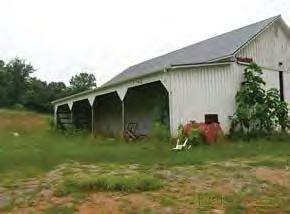
30 Improvements Description and Analysis 30 Parcel 2 Improvements (Photo Taken on October 4, 2013) Parcel 3 Improvements (Photo Taken on October 4, 2013) Parcel 4 Improvements (Photo Taken on October 4, 2013) Subject Improvements (Photo Taken on October 4, 2013) Loudoun Heights
31
32 Addenda Loudoun Heights
33 Addenda Loudoun Heights
34 Addenda Loudoun Heights
35 Addenda Loudoun Heights
36 Addenda Loudoun Heights
37 Addenda Loudoun Heights
38 Addenda Loudoun Heights
39 Addenda Loudoun Heights
40 Addenda Loudoun Heights
41 Addenda Loudoun Heights
42 Addenda Loudoun Heights
43 Zoning Information
44 ARTICLE 2 NON-SUBURBAN DISTRICT REGULATIONS DIVISION A: RURAL DISTRICTS Section AR-1 Agricultural Rural Purpose and Intent. The purpose and intent of the AR-1 district is to: (A) (B) (C) (D) (E) Support the use of land for rural economy uses, with residential uses allowed at densities consistent with the general open and rural character of the rural economy uses. Allow for a broad range of rural economy uses, including (agriculture, horticulture and animal husbandry), agriculture support and services associated with on-going agricultural activities, and other uses that can be developed in ways consistent with the rural character of the AR-1 district through mitigation or other standards. Recognize the County s tourism industry is interconnected with the rural economy and rural economy uses in the district by allowing for tourism uses related to agricultural uses, conference and training center uses, and rural activity and special event uses. Promote consistency between residential development and rural economy uses through lower density residential development or clustering of residential development. Ensure that the rural economy uses are compatible with any existing permitted residential development Use Regulations. Table summarizes the principal use regulations of the AR-1 district. (A) Organization of Use Table. Table organizes the uses in the AR-1 district by Use Classifications, Use Categories and Use Types. (1) Use Classifications. The Use Classifications are: agricultural uses; residential uses; public and institutional uses; commercial uses; and industrial uses. The Use Classifications provide a systematic basis for assigning present and future land uses into broad general classifications (e.g., agricultural uses and residential uses). The Use Classifications then organize land uses and 2-1 Section Revision Date: May 19, 2009
45 activities into general Use Categories and specific Use Types based on common functional, product, or physical characteristics, such as the type and amount of activity, the type of customers or residents, how goods or services are sold or delivered, and site conditions. (2) Use Categories. The Use Categories describe the major sub-groups of the Use Classification, based on common characteristics (e.g., the residential Use Classification is divided into two major Use Categories: Household Living and Group Living). Principal uses are identified in defining the Use Category. They are principal uses that most closely share the common characteristics that are key to the Use Category. (3) Use Types. The Use Categories are then divided into specific Use Types. The specific Use Types are included in the respective Use Category. They identify the specific uses that are considered to fall within characteristics identified in the Use Category. For example, single family detached dwellings, multi-family dwellings and town houses are Use Types in the Household Living Use Category. (B) (C) Use Categories and Use Types Defined. All the Use Categories and Use Types listed in Table are defined in Article VIII (Definitions). Permitted and Special Exception Uses. A P in the column identified AR-1 indicates that a Use Category or specific Use Type is permitted as a matter of right (as a permitted use) in the AR-1 district, subject to compliance with all applicable standards and regulations in this Ordinance and all other County ordinances. An S indicates that a Use Type is allowed in the AR-1 district as a special exception in accordance with the procedures and standards of Section An M indicates that a Use Type is allowed in the AR-1 district as a minor special exception in accordance with the procedures and standards of Section In some instances, and based on the Additional Regulations for Specific Uses (Section 5-600), a Use Type will be permitted as a matter of right under certain conditions or allowed as a special exception or minor special exception under other conditions. In those instances, it is identified as P/S or P/M, as appropriate. 2-2 Section Revision Date: May 19, 2009
46 (D) (E) (F) Reference to General Use Category. References to General Use Category under the Use Type column, means all of the uses in the Use Category are allowed. The Use Category is defined in Article VIII. Where specific Use Types are listed in the Use Type column, only the listed Use Types in the Use Category are allowed. The Use Types are defined in Article VIII. Additional Regulations for Specific Uses. References to sections in the final column of Table (AR-1 District Use Table) indicate that the listed use is subject to use-specific regulations. The numbers provide a cross-reference to the Additional Regulations for Specific Uses in Section Minimum Lot Size Requirements. Each principal permitted use shall meet the minimum acreage requirement, where specified in the Additional Regulations for Specific Uses in Section 5-600, for that use. Where two or more principal uses are located on one parcel, the parcel size shall be the larger of the two or more uses requirements, and not the sum of all the minimum lot sizes. TABLE 2-102: AR-1 AGRICULTURAL RURAL 1 DISTRICT USE TABLE P = PERMITTED S = SPECIAL EXCEPTION M=MINOR SPECIAL EXCEPTION USE CATEGORY USE TYPE AR-1 DISTRICT ADDITIONAL REGULATIONS FOR SPECIFIC USES AGRICULTURAL USES Agriculture General Use Category P Section Horticulture General Use Category P Section Animal Husbandry General Use Category P Section Agriculture Support and Services Directly Related to On-going Agriculture, Horticulture and Animal Husbandry Activity, On-Site Agricultural processing P Section Agri-education P Section Animal care business P Section Agritainment P Section Commercial winery with 20,000 square feet or less Commercial winery, over 20,000 square feet P Section S Section Section Revision Date: May 19, 2009
47 TABLE 2-102: AR-1 AGRICULTURAL RURAL 1 DISTRICT USE TABLE P = PERMITTED S = SPECIAL EXCEPTION M=MINOR SPECIAL EXCEPTION USE CATEGORY USE TYPE AR-1 DISTRICT ADDITIONAL REGULATIONS FOR SPECIFIC USES Custom operators P Section Direct market business for sale of products produced on-site including but not limited to PYO (pick-your-own) P Section Equestrian facilities P Section Farm based tourism P Section Farm co-ops P Section Farm machinery repair P Section Farm markets P Section Feedlot (for on-going, on-site animal husbandry activities) P Section Nursery, commercial S Section Nursery, production P Section Pet farms P Section Restaurant P Section Sawmill S Section Stables P Section Veterinary services Virginia Farm Winery P P Wayside stand P Section Wetlands mitigation bank P Section Section Revision Date: May 19, 2009
48 TABLE 2-102: AR-1 AGRICULTURAL RURAL 1 DISTRICT USE TABLE P = PERMITTED S = SPECIAL EXCEPTION M=MINOR SPECIAL EXCEPTION USE CATEGORY USE TYPE AR-1 DISTRICT ADDITIONAL REGULATIONS FOR SPECIFIC USES Agricultural research facility P Section Animal care businesses P Section Central farm distribution hub for agricultural products Commercial winery with 20,000 square feet or less Commercial winery, over 20,000 square feet P Section P Section S Section Equestrian facility P Section Agriculture Support and Services Not Directly Associated with On-Site Agricultural Activity Equestrian facility, on lots of less than 50 acres or without frontage on state maintained road M Section Farm machinery repair P Section Farm machinery sales, rental and service Mill feed and farm supply center P Section P Section Nursery, commercial S Section Stable, neighborhood, on lots of 25 acres or more, or frontage on state maintained road Stable, neighborhood, on lots of less than 25 acres or without frontage on state maintained road P Section M Section Stable, private P Section Animal hospital P Section Animal Services Kennel S Section Kennel, Indoor M Section RESIDENTIAL USES 2-5 Section Revision Date: May 19, 2009
49 TABLE 2-102: AR-1 AGRICULTURAL RURAL 1 DISTRICT USE TABLE P = PERMITTED S = SPECIAL EXCEPTION M=MINOR SPECIAL EXCEPTION USE CATEGORY USE TYPE AR-1 DISTRICT ADDITIONAL REGULATIONS FOR SPECIFIC USES Household Living Accessory dwelling (accessory to single family detached dwelling) Dwelling, single-family detached, including manufactured housing Home occupation (accessory to single family detached dwelling) Portable Dwelling/Trailer Construction Co-housing P Section P P Section P P May divide property in accordance with Section Development Options. Group Living Convent or monastery P/S Section Dormitory, seasonal labor M Section Rooming house P PUBLIC AND INSTITUTIONAL USES Aviation Airport/landing strip S Section Day Care Facilities Child care home P Section 5-609(A) Child or adult day care center S Section 5-609(B) Agricultural cultural center S Section Cultural and Government Facilities Education Park and Open Space Fairground S Section Structures or uses for local government purposes not otherwise listed in the district School (elementary, middle, or high) Vocational school Arboretum P Section Botanical garden or nature study area S S S P Section Section Revision Date: May 19, 2009
50 TABLE 2-102: AR-1 AGRICULTURAL RURAL 1 DISTRICT USE TABLE P = PERMITTED S = SPECIAL EXCEPTION M=MINOR SPECIAL EXCEPTION USE CATEGORY USE TYPE AR-1 DISTRICT ADDITIONAL REGULATIONS FOR SPECIFIC USES Cemetery S Section Mausoleum S Section Crematorium S Section Public Safety Religious Assembly Utility Community, neighborhood, or regional park, passive recreational uses Community, neighborhood, or regional park, active recreational uses Fire and/or rescue station P Section Police station or substation P Section Church, synagogue, temple or mosque, with seating capacity of 300 or less seats in sanctuary or main activity area Church, synagogue, temple or mosque, with seating capacity of more than 300 in sanctuary or main activity area, or accessory schools, day care centers with more than children, recreational facilities General Use Category Municipal drinking water supply reservoir P S P Section S Section Sewage Treatment Plant S Section P P Recycling drop-off collection center, public: Section Utility substation, transmission: Section 5-616(A) Utility substation, distribution: Section 5-616(B) Sewer Pumping Station P Section Water Storage Tank S Section Water Treatment Plant S Section Section Revision Date: May 19, 2009
51 TABLE 2-102: AR-1 AGRICULTURAL RURAL 1 DISTRICT USE TABLE P = PERMITTED S = SPECIAL EXCEPTION M=MINOR SPECIAL EXCEPTION USE CATEGORY USE TYPE AR-1 DISTRICT ADDITIONAL REGULATIONS FOR SPECIFIC USES Water Pumping Station P Section Utility transmission lines, overhead (excluding connections of lines from existing overhead public utility transmission lines to individual uses) S Unless excepted by Section 1-103(D) COMMERCIAL USES Conference Training Centers and Conference and training centers Rural agricultural corporate retreat P/M Section P Section Rural Resort M Section 5-601(C) Rural Retreat M Section 5-601(C) Food and Beverage Teahouse; coffeehouse P Section Banquet facility M Section Restaurant M Section Office Educational or research facilities use related to the agriculture, horticulture and animal husbandry uses in the district Camp, day and boarding, with 30 or fewer campers Camp, day and boarding, with more than 30 campers M Section P Section M Section Recreation Entertainment and Campground M Section Country Club S Section Cross country ski business P Section Eco-tourism P Section Section Revision Date: May 19, 2009
52 TABLE 2-102: AR-1 AGRICULTURAL RURAL 1 DISTRICT USE TABLE P = PERMITTED S = SPECIAL EXCEPTION M=MINOR SPECIAL EXCEPTION USE CATEGORY USE TYPE AR-1 DISTRICT ADDITIONAL REGULATIONS FOR SPECIFIC USES Golf course S Section Outdoor amphitheater S Section Private Club or Lodge Rural recreational establishment, outdoor S P Antique shop P Section Art gallery or art studio P Section Retail Sales and Service Auction house S Section Craft shop P Section Small business P/M Section Bed and breakfast P/M Section 5-601(A) Visitor Accommodation Country inn P/M Section 5-601(B) Guest farm or ranch leasing up to 20 guest rooms P INDUSTRIAL USES Radio and/or television tower S Section Telecommunications antenna P Section 5-618(A) Telecommunication Use and/or Structure Waste-Related Uses Telecommunications monopole Telecommunications monopole Telecommunications transmission tower Vegetative Management facility Waste P S S M Section 5-618(B)(1) Section 5-618(B)(2) Section 5-618(C)(2) (Grant of a special exception does not avoid requirements of Chapter 1080,Codified Ordinances of Loudoun County, or any other applicable law.) 2-9 Section Revision Date: May 19, 2009
53 TABLE 2-102: AR-1 AGRICULTURAL RURAL 1 DISTRICT USE TABLE P = PERMITTED S = SPECIAL EXCEPTION M=MINOR SPECIAL EXCEPTION USE CATEGORY USE TYPE AR-1 DISTRICT ADDITIONAL REGULATIONS FOR SPECIFIC USES Yard Waste Composting Facility Stockpiling of dirt S Section S (Grant of a special exception does not avoid requirements of Chapter 1080,Codified Ordinances of Loudoun County, or any other applicable law.) Development Options. Land within the AR-1 zoning district may be subdivided under one of the three development options identified below. Nothing in this section shall preclude the opportunity for a property owner to file for a Family Subdivision in accordance with the requirements of the Land Subdivision and Development Ordinance. (A) Base Density Division Option. A Base Density Division meeting the following standards and criteria may be permitted in accordance with the procedures outlined in the Land Subdivision and Development Ordinance (LSDO) for such division: (1) Lot Yield. Under the Base Density Division Option, the maximum lot yield shall be one lot per 20 acres. (2) Permitted Uses. The uses permitted on lots developed in accordance with the Base Density Division Option are identified in Table and are subject to the Additional Regulations for Specific Uses of Section (3) Lot and Building Requirements. (a) (b) (c) Minimum Lot Size. 20 acres. Minimum Lot Width. 175 feet. Minimum Yards. No structure shall be located within 25 feet of any property line or within 100 feet from the right-of-way of any arterial road, 75 feet from the right-of-way of any collector road, and 35 feet from any other road right-of-way, private access easement, and/or any prescriptive easement Section Revision Date: May 19, 2009
54 (d) (e) Maximum Lot Coverage. 11% maximum. Maximum Building Height. 35 feet, excluding agricultural, horticultural, and animal husbandry structures. (4) Creation of Lots. (a) (b) (c) Request. Requests for creation of lots by plat of division in the AR-1 District shall be submitted to the Director of the Department of Building and Development (or designee) for review and approval in accordance with AR-2 and AR-1 Divisions of the Land Subdivision and Development Ordinance. Public Road Frontage. No such lot shall be created fronting on a public road unless the publicly dedicated width of the road along the entire frontage of the newly created lot, measured from the centerline of the road to the property line of the lot, satisfies the criteria of the Virginia Department of Transportation (VDOT). Utility Requirements. Each lot shall have an onsite water supply and individual sewage disposal system. (5) Lot Access. (a) (b) (c) Access to individual lots may be provided by a private access easement that complies with the requirements of the Facilities Standards Manual. A private access easement may serve as frontage inlieu of public road frontage for up to 7 lots. The plat of division shall contain a note detailing the provisions for the maintenance of the private access easement. (B) Principal/Subordinate Subdivision Option: The Principal/Subordinate Subdivision Option is a subdivision of land in which a maximum lot yield is calculated for an Originating Tract based on the gross acreage of such tract. The maximum lot yield shall be as set forth in Subsection 2-103(B)(1)(b) below. The Principal/Subordinate Subdivision Option results in the creation of 2-11 Section Revision Date: May 19, 2009
55 one Principal Lot, and one or more Subordinate Lots. The number of Subordinate Lots created is subtracted from the maximum lot yield and the resulting number establishes the remaining number of lots, which is assigned to the Principal Lot. The creation of subsequent Subordinate Lots from the Principal Lot is permitted, with the number of lots assigned to the Principal Lot reduced by one for each Subordinate Lot created. Once the number of lots assigned to the Principal Lot is reduced to one, no more Subordinate Lots can be created. The Principal/Subordinate Subdivision Option typically allows the landowner to achieve a greater lot yield than the base density of the Base Density Division Option, while providing for the establishment of rural economy uses as a primary use with single-family detached residential development as a secondary use. (1) General Requirements. (a) (b) General. A landowner may exercise this option on a site consisting of a minimum of 20 acres prior to development. Lot Yield. The maximum lot yield shall be 1 lot per 10 acres. (2) Characteristics of Principal/Subordinate Subdivision Option. (a) The lot yield of a Principal/Subordinate Subdivision shall be calculated from the Originating Tract of land in existence at the time the first Principal/Subordinate Subdivision is created. (b) Once a Principal/Subordinate Subdivision is created, the number of lots assigned to the subdivision shall not be altered. (c) The lot yield of the Originating Tract shall be calculated with each preliminary and/or record plat. At the time of the first subdivision, the number of Subordinate Lots created is subtracted from the number of lots calculated for the Originating Tract and the remaining number of lots is then assigned to the Principal Lot. Each subsequently created Subordinate Lot is subtracted from the number of lots assigned to the Principal Lot and shall reduce 2-12 Section Revision Date: May 19, 2009
56 the number of lots assigned to the Principal Lot by one (1) for each lot. (d) (e) (f) A Principal Lot may be further subdivided, provided the minimum requirements of the Zoning Ordinance and Land Development and Subdivision Ordinance (LSDO) are met. Once the number of lots assigned to the Principal Lot is reduced to one, the Principal Lot may no longer be subdivided. Subordinate Lots shall not be further subdivided. The record plat and initial deed of conveyance after establishment of a subdivision lot under the Principal/ Subordinate Subdivision Option shall contain a statement to this effect. A subdivision of one or more lots may occur at one time or in a series of subdivisions up to the maximum lot yield calculated for the Originating Tract. (g) Any subdivision record plat for a Principal/Subordinate Subdivision shall contain a tabulation of density showing, in addition to all Land Subdivision and Development Ordinance (LSDO) requirements, the lot yield originally calculated for the Originating Tract, all prior subdivisions from the Originating Tract and each resulting Principal Lot and number of lots created pursuant to such subdivisions. (h) The Principal Lot shall be clearly labeled on each record plat. (i) Each Principal/Subordinate Subdivision shall contain at least one Rural Economy Lot of a minimum of 15 acres in size. (3) Permitted Uses. (a) Principal and Subordinate Lots. The uses permitted on lots developed in accordance with the Principal/Subordinate Development Option are identified in Table and are subject to the Additional Regulations for Specific Uses of Section Section Revision Date: May 19, 2009
57 (4) Lot and Building Requirements. The Lot and Building Requirements for development under the Principal/Subordinate Subdivision Option are identified below, except where the performance standards in Section (Additional Regulations for Specific Uses) specify different requirements for a particular use. (a) (b) Minimum Lot Size. 80,000 square feet, exclusive of major floodplain. At least one lot in the development shall be a Rural Economy Lot with a minimum of 15 acres. Minimum Lot Width. 175 feet. (c) Maximum Length/Width Ratio. 3:1. (d) Minimum Yards. No structure shall be located within 25 feet of any property line or within 100 feet from the right-of-way of any arterial road; 75 feet from the right-of-way of any collector road; or 35 feet from any other road right-of-way, private access easement, and/or any prescriptive easement. (e) Maximum Lot Coverage. 15%. (f) Building Height. 35 feet maximum, excluding agricultural, horticultural, and animal husbandry structures. (5) Landscaping/Buffering. Notwithstanding the requirements of Section , required buffers may be provided on either the Principal and/or Subordinate lot. (6) Utility Requirements. (a) (b) Water. All lots shall be served by individual water supply systems located on the lot. Sewer. All lots shall be served by individual sewage disposal systems located on the lot. (7) Fire Protection. The development shall satisfy the fire protection standards set forth in the Facilities Standards Manual Section Revision Date: May 19, 2009
Ensure that the rural economy uses are compatible with any existing permitted residential development.
 ection 2-100 Agricultural Rural-1 The provisions of this ection apply only to the areas now zoned Agricultural Rural-1 that were added to the corporate limits of the Town of Round Hill by the Boundary
ARTICLE 2 NON-SUBURBAN DISTRICT REGULATIONS DIVISION A: RURAL DISTRICTS
 ARTICLE 2 NON-SUBURBAN DISTRICT REGULATIONS DIVISION A: RURAL DISTRICTS AR-1 Agricultural Rural-1 2-101 urpose and Intent. The purpose and intent of the AR-1 district is to: (A) (B) (C) (D) (E) Support
Medium Density Residential Development Opportunity
 Medium Density Residential Development Opportunity 2 Land Tracts totaling 747 Acres Available individual or whole. 138 Park Farm Lane Stafford, VA 22406 Presented by: Wilson Greenlaw, CCIM Vice President
. Excellent location near Kansas Speedway/Village
 FOR SALE 220 Acres Master Planned Multifamily and Commercial Near Kansas Speedway Kansas Highway 7 126th Street SITE State Avenue The Plaza at Village West Legends Outlets Community America Ballpark Sporting
ALBEMARLE COUNTY CODE CHAPTER 18. ZONING SECTION 10. RURAL AREAS DISTRICT, RA
 CHAPTER 18. ZONING SECTION 10. RURAL AREAS DISTRICT, RA Sections: 10.1 Intent, where permitted. 10.2 Permitted uses. 10.2.1 By right. 10.2.2 By special use permit. 10.3 Application of regulations for development
2-1 TITLE 4 ZONING CODE 2-2
 2-1 TITLE 4 ZONING CODE 2-2 Chapter 2 RESIDENTIAL ZONING DISTRICTS Sec. 2-1: Sec. 2-2: Sec. 2-3: Sec. 2-4: Sec. 2-5: Sec. 2-6: Sec. 2-7: Sec. 2-8: Purpose Agriculture/Forestry Zoning District (AF) Farm,
> Electric: Shenandoah Valley. > Gas: No underground gas available; > Potential Uses: Retirement, Business Convention,
 Washington, DC Property Overview > Area: Luray, Virginia Page County > Improvements: 4,000 SF Clubhouse 2 Tennis Courts 18-Hole Golf Course > Parcel Size: 331 acres > Price: $9,000,000 > Water/Sewer: Town
5-703 Agricultural Rural (AR) District Cluster Option. (A)
 District Cluster Option. (A)") 5-703 Agricultural Rural (AR) District Cluster Option. (A) Purpose. The purpose of the Agricultural Rural (AR) District Cluster Option is to provide for residential singlefamily detached development in
5-703 Agricultural Rural (AR) District Cluster Option. (A) Purpose. The purpose of the Agricultural Rural (AR) District Cluster Option is to provide for residential singlefamily detached development in
Post Office Box 686 Springfield, Virginia P: F:
 High Visibility Flex Retail Warehouse Space For Lease PROPERTY ADDRESS: 8245 Backlick Rd, Suite A, Lorton, VA 22079, Fairfax County, Springfield / Newington Submarket, I-95 Corridor SPACE AVAILABILITY
Commercial Building for Lease. For Lease at $10.00/SF Gross + Expenses
 Commercial Building for Lease EXECUTIVE SUMMARY 232-242 Boston Post Road Milford, Connecticut 06460 For Lease at $10.00/SF Gross + Expenses 5,750 SF freestanding building with direct access from Plains
CHARLOTTE CODE. PART 1: PURPOSE AND PART 2: MIXED USE DISTRICTS (MX-1, MX-2, and MX-3) CHAPTER 11:
 CHAPTER 11:") PART 1: PURPOSE AND PART 2: MIXED USE DISTRICTS (MX-1, MX-2, and MX-3) Section 11.101. Purpose. CHAPTER 11: CONDITIONAL ZONING DISTRICTS PART 1: PURPOSE The Conditional Zoning Districts allow for the establishment
PART 1: PURPOSE AND PART 2: MIXED USE DISTRICTS (MX-1, MX-2, and MX-3) Section 11.101. Purpose. CHAPTER 11: CONDITIONAL ZONING DISTRICTS PART 1: PURPOSE The Conditional Zoning Districts allow for the establishment
SECTION 817 "AL" - LIMITED AGRICULTURAL DISTRICT
 SECTION 817 "AL" - LIMITED AGRICULTURAL DISTRICT The "AL" District is a limited agricultural district. It is intended to protect the general welfare of the agricultural community by limiting intensive
Coomber Hall at McMillen Farm 1521 Dranesville Road Herndon, VA
 Coomber Hall at McMillen Farm 1521 Dranesville Road Herndon, VA OFFERING MEMORANDUM Prime Infill Single Family Lot Opportunity CONTENTS Offering Terms 3 Executive Summary 4 Property Summary 5 Investment
PLANNING COMMISSION REPORT Regular Agenda Public Hearing Item
 PC Staff Report 11/12/12 Item No. 2B- 1 PLANNING COMMISSION REPORT Regular Agenda Public Hearing Item ITEM NO. 2B: A TO GPI; 110 ACRES; E OF K-10 & N OF W 6 TH ST (MKM) : Consider a request to rezone approximately
ARTICLE V AGRICULTURAL PRESERVATION AND RURAL RESIDENTIAL DISTRICT
 ARTICLE V AP AGRICULTURAL PRESERVATION AND RURAL RESIDENTIAL DISTRICT Section 500. PURPOSE It is the purpose of the AP, Agricultural Preservation and Rural Residential District, to foster the preservation
Residential Project Convenience Facilities
 Standards for Specific Land Uses 35.42.220 E. Findings. The review authority shall approve a Land Use Permit in compliance with Subsection 35.82.110.E (Findings required for approval) or a Conditional
ZRTD , Glenn Drive. M. Tyler Klein, AICP, Project Manager, Planning and Zoning John Merrithew, Acting Director, Planning and Zoning
 DEPARTMENT OF PLANNING Date of Hearing: AND ZONING STAFF REPORT # 4 BOARD OF SUPERVISORS PUBLIC HEARING SUBJECT: ELECTION DISTRICT: ZRTD-2014-0003, 22675 Glenn Drive Broad Run CRITICAL ACTION DATE: September
CHAPTER RESIDENTIAL AND OPEN SPACE ZONING DISTRICTS
 Residential and Open Space Zoning Districts 106.24.010 CHAPTER 106.24 - RESIDENTIAL AND OPEN SPACE ZONING DISTRICTS RESIDENTIAL AND OPEN SPACE ZONING DISTRICTS Sections: 106.24.010 - Purpose 106.24.020
ARTICLE 8 R-2 MULTIPLE FAMILY RESIDENTIAL DISTRICT
 ARTICLE 8 R-2 MULTIPLE FAMILY RESIDENTIAL DISTRICT SECTION 800 STATEMENT OF PURPOSE This district classification is designed to permit the greatest density of residential uses allowed within the Township,
Sec HC - Highway commercial district.
 Sec. 36-422. - HC - Highway commercial district. (1) Purpose. This district is intended for commercial uses which depend upon high visibility, generate high traffic volumes, or cater to the traveling public.
OFFERING CIRCULAR Acres Rural Industrial Zone 6855 NW Cornelius-Schefflin Rd. Cornelius, Oregon. Presented by:
 OFFERING CIRCULAR 16.54 Acres Rural Industrial Zone 6855 NW Cornelius-Schefflin Rd. Cornelius, Oregon Presented by: The information contained in this offering circular was provided to Agri-Investment Services
1.25 AC Residential Land
 FOR SALE $79,000 Property Details PARCEL ID 3414-501-1010-200-0 PRICE $79,000 A perfect spot for a new dream home! 1.25 AC lot is tucked away in a rural area of Port St. Lucie and just within 2 miles to
ARTICLE III: LAND USE DISTRICTS 304 R 9 DISTRICT
 ARTICLE III: LAND USE DISTRICTS III 23 304 R 9 DISTRICT (RESIDENTIAL 9 UNITS PER ACRE) 304 1 Intent and Purpose The R 9 District is intended to implement the policies of the Comprehensive Plan for areas
d. DWELLING, GROUP QUARTERS (no more than sixteen [16] persons, including domestic servants and resident staff).
![d. DWELLING, GROUP QUARTERS (no more than sixteen [16] persons, including domestic servants and resident staff).](/thumbs/93/113051450.jpg "d. DWELLING, GROUP QUARTERS (no more than sixteen [16] persons, including domestic servants and resident staff).") SEC. 37-7.5. R-5 GENERAL RESIDENCE DISTRICT The R-5 General Residence District is established to provide for a range of low density residential accommodations and life styles representing a compatible
SEC. 37-7.5. R-5 GENERAL RESIDENCE DISTRICT The R-5 General Residence District is established to provide for a range of low density residential accommodations and life styles representing a compatible
CHAPTER 6 RESIDENTIAL DISTRICTS LOW DENSITY RESIDENTIAL DISTRICT (R-1)
") TYPE OF DISTRICT: TRADITIONAL CHAPTER 6 RESIDENTIAL DISTRICTS LOW DENSITY RESIDENTIAL DISTRICT (R-1) ARTICLE 1: LOW DENSITY RESIDENTIAL DISTRICT (R-1) SECTION 6-1.01: PURPOSE The regulations of the R-1
TYPE OF DISTRICT: TRADITIONAL CHAPTER 6 RESIDENTIAL DISTRICTS LOW DENSITY RESIDENTIAL DISTRICT (R-1) ARTICLE 1: LOW DENSITY RESIDENTIAL DISTRICT (R-1) SECTION 6-1.01: PURPOSE The regulations of the R-1
2. The following Greenbelt Zones are established:
 Subdivision 1 - General 9.7.1. Purpose 1. The purposes for establishing Greenbelt Zones are listed below: a. to concentrate intensive commercial, industrial, and residential development in the Kitimat
301. Zoning Districts. C-D A-1 R-1 R-V B-1 I-1
 301. Zoning Districts. The Township is divided into the districts set forth by this chapter and as shown by the district boundaries on the Official Zoning District Map. The zoning districts are: C-D Conservation
Ranch Style Estate / ALF Opportunity
 FOR SALE $459,000 Property Details PRICE $459,000 Ranch-style home located in St Lucie Gardens (horse country) consists of 6 bed / 6 bath home on a 1.25 AC parcel. BUILDING SIZE 3,495 sf Ideal as an assisted
ARTICLE C. ZONING TEXT, DISTRICT CLASSIFICATIONS AND BOUNDARIES
 ARTICLE C. ZONING TEXT, DISTRICT CLASSIFICATIONS AND BOUNDARIES Sec. 10-2054. ZONING TEXT, DISTRICT CLASSIFICATIONS AND BOUNDARIES. In order to regulate the location of structures, the height and bulk
SUMMARY OF AMENDMENTS TO THE AGENDA Monroe County Planning Commission October 11, 2017
 SUMMARY OF AMENDMENTS TO THE AGENDA Monroe County Planning Commission October 11, 2017 8. New Business: A. Consent Agenda: Additions Township Zoning Reviews 200.1-10-17-32 Whiteford Township (map) This
Subchapter 5 Zoning Districts and Limitations
 Subchapter 5 Zoning Districts and Limitations 35.5.1 Rural Districts Sections: 35.5.1.1 Purpose. 35.5.1.2 Permitted Uses. 35.5.1.3 General Regulations. 35.5.1.1 Purpose. The purpose of a Rural District
SEC R-3 SINGLE FAMILY RESIDENCE DISTRICT
 SEC. 37-7.3. R-3 SINGLE FAMILY RESIDENCE DISTRICT The R-3 Single Family Residence District is established to preserve and maintain existing single family areas of the County and permit the continued development
SECTION 817 "AL" - LIMITED AGRICULTURAL DISTRICT
 SECTION 817 "AL" - LIMITED AGRICULTURAL DISTRICT The "AL" District is a limited agricultural district. It is intended to protect the general welfare of the agricultural community by limiting intensive
MONTROSE COUNTY COMMERCE PARK
 MONTROSE COUNTY COMMERCE PARK South Highway 550 and Vernal Road 81403 Vernal Road Entrance South Hwy 550 Frontage Paved Streets with Utilities Commercial Development Information Packet John Renfrow * Joey
THE ATRIUM CONDOMINUM ROGER BACON DRIVE - UNIT 10, RESTON, VA 20190
 RESTON OFFICE CONDOMINIUM FOR LEASE THE ATRIUM CONDOMINUM 11250 ROGER BACON DRIVE - UNIT 10, RESTON, VA 20190 LEASE RATE: PROPERTY TYPE: AVAILABLE SF: $4,440 Plus Elec Office Condo 2,794 SF PROPERTY OVERVIEW
2.110 COMMERICAL MIXED USE (CM)
") CITY OF KEIZER DEVELOPMENT BULLETIN 2.110.01 Purpose 2.110 COMMERICAL MIXED USE (CM) The Commercial Mixed Use (CM) zone is the primary commercial zone within the City. The zone is specifically designed
CITY OF KEIZER DEVELOPMENT BULLETIN 2.110.01 Purpose 2.110 COMMERICAL MIXED USE (CM) The Commercial Mixed Use (CM) zone is the primary commercial zone within the City. The zone is specifically designed
ARTICLE 7 R-1 ONE FAMILY RESIDENTIAL DISTRICT
 ARTICLE 7 R-1 ONE FAMILY RESIDENTIAL DISTRICT SECTION 700 STATEMENT OF PURPOSE This district classification is designed to be the most restrictive of the residential districts intended to encourage an
CCC XXX Rural Neighborhood Conservation (NC)
") CCC 33.10.XXX Rural Neighborhood Conservation (NC) Purpose: Maintain low density rural residential areas and associated uses commonly found in rural areas consistent with the local character of the distinctive
CCC 33.10.XXX Rural Neighborhood Conservation (NC) Purpose: Maintain low density rural residential areas and associated uses commonly found in rural areas consistent with the local character of the distinctive
ZONE TITLE: RESIDENTIAL MEDIUM DENSITY (RMD)
") ZONE TITLE: RESIDENTIAL MEDIUM DENSITY (RMD) RMD USE CLASSIFICATIONS Permitted Use Classes (see Regulation 101) Single Dwelling, Recreational Open Space, Conservation (see Schedules A and B for definitions
ZONE TITLE: RESIDENTIAL MEDIUM DENSITY (RMD) RMD USE CLASSIFICATIONS Permitted Use Classes (see Regulation 101) Single Dwelling, Recreational Open Space, Conservation (see Schedules A and B for definitions
For Sale. 2,880+/- sf bldg on 3.64+/- acres. Formerly operated as Alternative Automotive. Frontage and signage on Memorial Hwy. Ample parking.
 For Sale 17530 State Route 536 Mount Vernon, WA 2,880+/- sf bldg on 3.64+/- acres Formerly operated as Alternative Automotive. Frontage and signage on Memorial Hwy. Ample parking. Furniture, Fixtures and
PRICED TO MOVE! For Sale 9378 Robins Neck Road Gloucester, Virginia
 For Sale 9378 Robins Neck Road Gloucester, Virginia PRICED TO MOVE! FOR ADDITIONAL INFORMATION, PLEASE CONTACT: Campana Waltz Real Estate, LLC Vince Campana 11832 Fishing Point Drive, Suite 400 Newport
Suburban Commercial Center ( CE-S ) Permitted Principal Uses and Structures
 Permitted Principal Uses and Structures") Division 12. Suburban Commercial Center ( CE-S ) 2.9.1 Purpose Suburban commercial centers provide regional commercial destinations with design and site elements compatible with suburban character. Dimensional
Division 12. Suburban Commercial Center ( CE-S ) 2.9.1 Purpose Suburban commercial centers provide regional commercial destinations with design and site elements compatible with suburban character. Dimensional
Clarke County Zoning Ordinance, Code Chapter 188 Section 3 Page Version
 Table of Contents Section 3 Page 3 DISTRICT REGULATIONS... 1 3-A SCHEDULE OF DISTRICT REGULATIONS... 1 3-A-1 Agricultural-Open Space-Conservation District - AOC... 1 3-A-2 Forestal-Open Space-Conservation
FOR SALE: $500, I-25 W Frontage Road, Santa Fe, NM 87505
 LAND FOR SALE - R1 DEVELOPMENT OPPORTUNITY SALE PRICE: $500,000 PRICE PER ACRE: $31,949 LOT SIZE: 15.65 Acres ZONING: R-1 I-25 Frontage Rd CROSS STREETS: Between Cerillos Rd & 599 PROPERTY OVERVIEW Great
ARTICLE III: LAND USE DISTRICTS AGRICULTURE AND FOREST DISTRICT (AF-10)
") ARTICLE III: LAND USE DISTRICTS III-153 346 AGRICULTURE AND FOREST DISTRICT (AF-10) 346-1 Intent and Purpose The AF-10 District is intended to retain an area s rural character and conserve the natural
ARTICLE III: LAND USE DISTRICTS III-153 346 AGRICULTURE AND FOREST DISTRICT (AF-10) 346-1 Intent and Purpose The AF-10 District is intended to retain an area s rural character and conserve the natural
Day care centers: Such uses shall require a Special Permit under the terms of Article VIII of this chapter.
 Page 1 of 12 DIVISION 1. - R-1 RESIDENTIAL ZONE Sec. 38-41. - Permitted uses. Single-family dwellings, excluding factory manufactured homes constructed as a single selfcontained unit and mounted on a single
45245 BUSINESS COURT STERLING, VA EXECUTIVE SUMMARY
 45245 BUSINESS COURT EXECUTIVE SUMMARY STERLING, VA EXECUTIVE SUMMARY Holliday exclusive mile from the future Route 606 Metrorail Station and accessible representative for the Owner, is pleased to present
7.58 AC Waterfront Land
 FOR SALE $1,000,000 Property Details PRICE $1,000,000 PARCEL ID 14-39-40-000-001-00010-1 ACREAGE 7.58 AC FRONTAGE +/- 639.92 Great piece of land with huge potential! 7.58 acres located in the agricultural
ARTICLE 6. GREER ZONES
 ARTICLE 6. GREER ZONES Section 601. Definitions and application of Greer Zones A. In this Article, unless otherwise specified: GA-2 means Greer Agricultural Zone GR-1 means Greer Residential Zone GC means
A. Location. A MRD District may be permitted throughout the County provided it meets the standards established herein.
 752. Multi-Residential District (MRD) The Multi-Residential (MRD) District is intended to provide opportunities for rural, suburban and urban density mixed-residential developments consistent with the
1.36 ACRE - DEVELOPMENT PARCEL AVAILABLE NOW
 1.36 ACRE - DEVELOPMENT PARCEL AVAILABLE NOW 3911 Challenger Ave, Roanoke, VA 24012 SALE PRICE: $599,900 PROPERTY OVERVIEW Commercial developmental land lot consisting of 1.36 acres in prime location off
ARTICLE 6 RU, RURAL ZONING DISTRICTS. RU (Rural) Zoning Districts are established to achieve the following purposes:
 Zoning Districts are established to achieve the following purposes:") ARTICLE 6 RU, RURAL ZONING DISTRICTS 601 Purpose RU (Rural) Zoning Districts are established to achieve the following purposes: 601.01 To preserve the character of areas designated as "Rural" in the Cochise
ARTICLE 6 RU, RURAL ZONING DISTRICTS 601 Purpose RU (Rural) Zoning Districts are established to achieve the following purposes: 601.01 To preserve the character of areas designated as "Rural" in the Cochise
ARTICLE IV DISTRICT REGULATIONS
 PART 1. RESIDENTIAL DISTRICTS 4-101. RS. Single-Family Residential Suburban District. The RS District is designed for single-family dwellings, and compatible uses, at a density no greater than one dwelling
PLANNING REPORT Gordon Street City of Guelph. Prepared on behalf of Ontario Inc. March 17, Project No. 1507
 PLANNING REPORT 1131 Gordon Street City of Guelph Prepared on behalf of 1876698 Ontario Inc. March 17, 2016 Project No. 1507 423 Woolwich Street, Suite 201, Guelph, Ontario, N1H 3X3 Phone (519) 836-7526
Chapter 210 CONDITIONAL USES
 Chapter 210 CONDITIONAL USES 210.01 Purpose 210.02 Authorization 210.03 Process Type 210.04 Determination of Major or Minor Conditional Use Review 210.05 Approval Criteria 210.06 Conditions of Approval
ARTICLE III District Regulations. A map entitled "Franklin Zoning Map" is hereby adopted as part of this chapter 1.
 ARTICLE III District Regulations ~ 305-8. Adoption of Zoning Map. A map entitled "Franklin Zoning Map" is hereby adopted as part of this chapter 1. ~ 305-9. Official Zoning Map; amendments. Regardless
8Land Use. The Land Use Plan consists of the following elements:
 8Land Use 1. Introduction The Land Use Plan consists of the following elements: 1. Introduction 2. Existing Conditions 3. Opportunities for Redevelopment 4. Land Use Projections 5. Future Land Use Policies
Integra Realty Resources Atlanta. Appraisal of Real Property
 Integra Realty Resources Atlanta Appraisal of Real Property Religious Facility Property 441 Martin Luther King, Jr. Drive Atlanta, Fulton County, Georgia 30313 Prepared For: Georgia State Properties Commission
ARTICLE PERMISSIVE USES. A building or premises shall be permitted to be used for the following purposes in the A-1 Agricultural District:
 ARTICLE 3.00 A-1 AGRICULTURAL SECTIONS: 3.01 Intent 3.02 Permissive Uses 3.03 Permitted Special Uses 3.04 Conditional Uses 3.05 Accessory Uses 3.06 Parking Regulations 3.07 Sign Regulations 3.08 Density,
Members of the City of Brantford Committee of Adjustment. 1.0 TYPE OF REPORT Committee of Adjustment Decision Regarding an Application for Consent
 DATE: October 18 th 2017 REPORT NO. CD2017-168 TO: Members of the City of Brantford Committee of Adjustment FROM: Brandon Kashin, Current Development Planner 1.0 TYPE OF REPORT Committee of Adjustment
Planning Department Oconee County, Georgia
 Planning Department Oconee County, Georgia STAFF REPORT REZONE CASE #: 6985 DATE: October 31, 2016 STAFF REPORT BY: Andrew C. Stern, Planner APPLICANT NAME: Williams & Associates, Land Planners PC PROPERTY
CITGO GAS STATION HUNTSVILLE, AL OFFERING MEMORANDUM 2064 HIGHWAY 72 EAST HUNTSVILLE, AL 35811
 CITGO GAS STATION HUNTSVILLE, AL OFFERING MEMORANDUM 2064 HIGHWAY 72 EAST HUNTSVILLE, AL 35811 OFFERING MEMORANDUM THIS IS AN OFFERING MEMORANDUM intended for the Citgo Gas Station located at 2064 Highway
ARTICLE VIII. ZONING DISTRICTS DIVISION 1. PERMITTED USES
 Sec. 130-241. Use tables. ARTICLE VIII. ZONING DISTRICTS DIVISION 1. PERMITTED USES (a) Tables 1 and 2 list all use types and all zoning districts where the use type is permitted ( P ) or permitted with
NET LEASE INVESTMENT OFFERING. 7-ELEVEN (Corporate) 8211 Old Centreville Road Manassas, VA (Washington, D.C. MSA)
 8211 Old Centreville Road Manassas, VA (Washington, D.C. MSA)") 7-ELEVEN (Corporate) 8211 Old Centreville Road Manassas, VA 20111 (Washington, D.C. MSA) TABLE OF CONTENTS TABLE OF CONTENTS I. Executive Profile Executive Summary Investment Highlights Property Overview
7-ELEVEN (Corporate) 8211 Old Centreville Road Manassas, VA 20111 (Washington, D.C. MSA) TABLE OF CONTENTS TABLE OF CONTENTS I. Executive Profile Executive Summary Investment Highlights Property Overview
Part 3 Specific Use Provisions (Sections 80-95)
") Part 3 Specific Use Provisions (Sections 80-95) Specific Use Provisions are described in this part. These provisions apply, on a City-wide basis, to a particular land use (e.g. snow disposal facilities,
Part 3 Specific Use Provisions (Sections 80-95) Specific Use Provisions are described in this part. These provisions apply, on a City-wide basis, to a particular land use (e.g. snow disposal facilities,
For Sale / Lease 156 Strawberry Plains Road Williamsburg, Virginia
 For Sale / Lease 156 Strawberry Plains Road Williamsburg, Virginia FOR ADDITIONAL INFORMATION, PLEASE CONTACT: Campana Waltz Commercial Real Estate, LLC Ron A. Campana, Jr. 11832 Fishing Point Drive, Suite
ARTICLE 5 AG AGRICULTURAL AND RURAL DISTRICT Updated
 ARTICLE 5 AG AGRICULTURAL AND RURAL DISTRICT Updated 2-24-14 Sec. 5.01 DESCRIPTION AND PURPOSE. This zone is intended for tracts of land within the township that are best suited and located for agricultural
CHAPTER ZONING DISTRICTS. For the purposes of this title, the city is divided into districts designated as follows:
 CHAPTER 17.30 ZONING DISTRICTS 17.30.00 ZONING DISTRICT DESIGNATIONS For the purposes of this title, the city is divided into districts designated as follows: DISTRICT SYMBOL Parks and Open Space POS Residential
Part 4, C-D Conservation District
 The Township is divided into the districts set forth by this chapter and as shown by the district boundaries on the Official Zoning District Map. The zoning districts are: C-D Conservation District A-1
ARTICLE 834. PD 834. PD 834 was established by Ordinance No , passed by the Dallas City Council on December 8, (Ord.
 ARTICLE 834. PD 834. SEC. 51P-834.101. LEGISLATIVE HISTORY. PD 834 was established by Ordinance No. 28070, passed by the Dallas City Council on December 8, 2010. (Ord. 28070) SEC. 51P-834.102. PROPERTY
Chapter RESIDENTIAL ZONING DISTRICTS
 Chapter 18.16 RESIDENTIAL ZONING DISTRICTS Sections: 18.16.010 Purpose of Chapter 18.16.020 Purpose of Residential Zoning Districts 18.16.030 Regulations for Residential Zoning Districts 18.16.040 Residential
TOWN OF HERNDON, VIRGINIA ORDINANCE, 2016
 TOWN OF HERNDON, VIRGINIA ORDINANCE, 2016 Ordinance- to amend and reenact Chapter 78 of the Code of the Town of Herndon entitled Zoning, Sections 78-204, 78-400, and 78-403 to make changes for internal
ARTICLE III: LAND USE DISTRICTS 302 R 5 DISTRICT
 ARTICLE III: LAND USE DISTRICTS III 7 302 R 5 DISTRICT (RESIDENTIAL 5 UNITS PER ACRE) 302 1 Intent and Purpose The R 5 District is intended to implement the policies of the Comprehensive Plan for areas
CHAPTER 11 TOWN OF LISBON ZONING ORDINANCE
 SECTION 9 UC UPLAND CORRIDOR DISTRICT (a) (b) Purpose and Intent Upland Corridor District, as mapped or intended to be mapped, includes non-wetland/non-floodplain primary or secondary environmental corridors
9.3 Downtown Commercial (CDT1, CDT2, CDT3)
") 9.3 Downtown Commercial (CDT1, CDT2, CDT3) 9.3.1 Purpose The zone provides for a broad range of commercial, service, business, entertainment and residential needs typical of a City Centre. The zone is
9.3 Downtown Commercial (CDT1, CDT2, CDT3) 9.3.1 Purpose The zone provides for a broad range of commercial, service, business, entertainment and residential needs typical of a City Centre. The zone is
CHAPTER URBAN TRANSITION - UT ZONE
 CHAPTER 16.13 URBAN TRANSITION - UT ZONE Section Title Page 16.13.000 Purpose 1 16.13.010 Uses 1 16.13.020 Conditional Uses 2 16.13.030 Conditional Use Criteria 3 16.13.040 Prohibited Uses 4 16.13.100
EXHIBIT A. City of Corpus Christi Annexation Guidelines
 City of Corpus Christi Annexation Guidelines Purpose: The purpose of this document is to describe the City of Corpus Christi s Annexation Guidelines. The Annexation Guidelines provide the guidance and
RURAL GENERAL RG 1. PERMITTED USES DISCRETIONARY USES
 RURAL GENERAL RG PURPOSE: To protect the agricultural land base of the municipality while allowing nonagricultural developments which complement the area's economy. 1. PERMITTED USES DISCRETIONARY USES
1057 Canton RD Marietta, GA 30066
 1057 Canton RD Marietta, GA 30066 +/- 1.49 Acres Presently Zoned LI $350,000 With all utilities available. Very little lot prep necessary for most uses. Two Level steppes descending from the street level.
Town of Prescott Valley 2013 Land Use Assumptions
 Town of Prescott Valley 2013 Land Use Assumptions Raftelis Financial Consultants, Inc. November 22, 2013 Table of Contents Purpose of this Report... 1 The Town of Prescott Valley... 2 Summary of Land Use
Existing Land Use. Typical densities for single-family detached residential development in Cumberland County: 1
 Existing Land Use A description of existing land use in Cumberland County is fundamental to understanding the character of the County and its development related issues. Economic factors, development trends,
Existing Conditions: Economic Market Assessment
 Existing Conditions: Economic Market Assessment Introduction The US 24/40 Corridor Study examined existing conditions as they related to economic and commercial market assessments, existing land use, and
2014 Plan of Conservation and Development
 The Town of Hebron Section 1 2014 Plan of Conservation and Development Community Profile Introduction (Final: 8/29/13) The Community Profile section of the Plan of Conservation and Development is intended
BUILD-OUT ANALYSIS GRANTHAM, NEW HAMPSHIRE
 BUILD-OUT ANALYSIS GRANTHAM, NEW HAMPSHIRE A Determination of the Maximum Amount of Future Residential Development Possible Under Current Land Use Regulations Prepared for the Town of Grantham by Upper
Staff Report: Date: Applicant: Property Identification: Acreage of Request: Current Zoning of Requested Area: Requested Action: Attached:
 Staff Report: Completed by Jeff Palmer Director of Planning & Zoning Date: November 7, 2018, Updated November 20, 2018 Applicant: Greg Smith, Oberer Land Developer agent for Ronald Montgomery ET AL Property
PLANNING COMMISSION PUBLIC HEARING STAFF REPORT ZRTD FAIRFAX MARBLE & GRANITE
 Date of Hearing: PLANNING COMMISSION PUBLIC HEARING STAFF REPORT SUBJECT: ELECTION DISTRICT: ZRTD-2016-0009 FAIRFAX MARBLE & GRANITE Broad Run CRITICAL ACTION DATE: September 27, 2017 STAFF CONTACTS: APPLICANT:
"NU" Non Urban District Regulations.
 1003.107 "NU" Non Urban District Regulations. 1. Scope of provisions. This section contains the district regulations of the "NU" Non-Urban District. These regulations are supplemented and qualified by
CHAPTER 50 LAND USE ZONES ARTICLE 50 BASIC PROVISIONS
 CHAPTER 50 LAND USE ZONES ARTICLE 50 BASIC PROVISIONS 50.010 - PURPOSE The purposes of this chapter are to establish land use zones required to implement the goals and policies of the Klamath County Comprehensive
City of Fraser Residential Zoning District
 City of Fraser Residential Zoning District The one-family districts are established to provide principally for one-family dwellings at varying densities. The specific interest of these districts is to
"NU" Non-Urban District Regulations.
 1003.107 "NU" Non-Urban District Regulations. 1. Scope of Provisions. This section contains the district regulations of the "NU" Non-Urban District. These regulations are supplemented and qualified by
Special Use Permit - Planned Unit Development Checklist. Property Address:
 Special Use Permit - Planned Unit Development Checklist Special Use Permit Number. Parcel Code/s #28-11- - - Property Address: Applicant: ARTICLE VIII Ordinance Reference - Section 8.1.2 Permit Procedures:
Glades County Staff Report and Recommendation REZONING
 Glades County Staff Report and Recommendation REZONING CASE NUMBER: RZ15-01 DATE: October 2, 2015 CASE TYPE: Application for Rezoning REQUEST: J.J. Wiggins Memorial Trust is requesting a rezoning of 22.1±
PART 9: RURAL AREA ZONING DISTRICTS
 9.1. AREA DESCRIPTION PART 9: RURAL AREA ZONING DISTRICTS The Rural Area consists of the areas of the County that are not part of the Urban Service Area. 9.2. A - Airport 9.2.1. Purpose To provide for
Residential-1 District
 Residential-1 District City of Barnum, Minnesota Zoning District Information Sheet It is the purpose of the R-1 District to encourage the establishment and the preservation of residential neighborhoods
CHAPTER 7 WR WATERFRONT RESIDENTIAL DISTRICT
 SECT ION 7.01 SECT ION 7.02 SECT ION 7.03 SECT ION 7.04 CHAPTER 7 WR WATERFRONT RESIDENTIAL DISTRICT DESCRIPTION AND PURPOSE This District is intended for medium density single family residential development
Prince Edward County Zoning Ordinance. Effective October 1, 2007
 Prince Edward County Zoning Ordinance Effective October 1, 2007 ARTICLE I GENERAL PROVISIONS...6 SEC. 1-100 TITLE AND AUTHORITY...6 SEC. 1-102 JURISDICTION...6 SEC. 1-104 PURPOSE...6 SEC. 1-106 EFFECTIVE
1060 EAST MAIN STREET BLUE BALL, PA 17506
 For Sale/Lease 717.293.4477 1060 EAST MAIN STREET BLUE BALL, PA 17506 William Boben, CCIM, SIOR Michael Bowser 717.209.4012 direct line 717.293.4553 direct line bboben@high.net mbowser@high.net Table of
Division 4 Large Lot Residential Zone: Assessment Criteria and Assessment Tables
 Division 4 Large Lot Residential Zone: Assessment Criteria and Assessment Tables 4.4.1 Large Lot Residential Zone The provisions in this division relate to the Large Lot Residential Zone as follows overall
SECTION 8 - GENERAL RURAL DISTRICT
 SECTION 8 - GENERAL RURAL DISTRICT Subdivision 1. Purpose The purpose of the General Rural District is to provide locations for agriculture, agriculturallyrelated development, and housing on lots without
Bylaw No , being "Official Community Plan Bylaw, 2016" Schedule "A" DRAFT
 Bylaw No. 2600-2016, being "Official Community Plan Bylaw, 2016" Schedule "A" Urban Structure + Growth Plan Urban Structure Land use and growth management are among the most powerful policy tools at the