PLEASANT HILL CITY COUNCIL REGULAR SESSION DECEMBER 18, :30 PM
|
|
|
- Blaze Hudson
- 5 years ago
- Views:
Transcription
 5. CONSENT ITEMS a. Council Minutes - dated 12-11-18 b.")
1 PLEASANT HILL CITY COUNCIL REGULAR SESSION DECEMBER 18, :30 PM 1. CALL TO ORDER/ROLL CALL 2. APPROVAL OF AGENDA 3. PUBLIC HEARING Amendments to Chapter 160 Flood Plain Regulations a. First Reading of Ordinance 849 Amending Chapter 160 Flood Plain Regulations 4. PUBLIC INPUT (5 MINUTES FOR ITEMS NOT ON THE AGENDA) 5. CONSENT ITEMS a. Council Minutes - dated b. Claims Listing - dated c. Expenditure Report - dated d. Revenue Report - dated e. Treasurer's Report - dated f. Public Works Dept. Monthly Report dated November 2018 g. Resolution # Setting a Public Hearing Date for General Obligation Urban Renewal Fire Department and Library Improvements Loan Agreement h. Resolution # Accept Offer to Purchase Real Estate and Acceptance of Warranty Deed with Oakridge Estates Partnership i. Resolution # Approval of Offer to Purchase Real Estate and Acceptance to Larry E. and Sandra A. Fleck for Pleasant Hill Boulevard and Vandalia Road Intersection Improvement Project j. Resolution # Setting Public Hearing to Approve and Authorize the Transfer of Real Property to Larry E. and Sandra A. Fleck k. Resolution # Setting Public Hearing to Approve Warranty Deed for Property Transfer to Southeast Polk School District 6. BUSINESS ITEMS a. Approval of Special Event Application for Springtime Hill Climb April 6, 2019 b. Resolution # Offer to Purchase Easement in Real Estate with MidAmerican Energy Company for Pleasant Hill Blvd and Vandalia Rd Intersection Project 7. CLOSING COMMENT 8. ADJOURNMENT 1
2 CITY OF PLEASANT HILL, IOWA CITY COUNCIL AGENDA COMMUNICATION DATE: DECEMBER 18, 2018 TO: FROM: SUBJECT: MAYOR & CITY COUNCIL MADELINE STURMS, AICP, CPM COMMUNITY DEVELOPMENT DIRECTOR ORDINANCE 849 FLOODPLAIN REGULATIONS BACKGROUND: Earlier this year, FEMA finalized the new Polk County Flood Insurance Rate Maps following an extensive review and comment period. The new flood maps will become effective on February 1, 2019 and the City is required to update the adopted floodplain ordinance to ensure compliance with the regulations of the National Flood Insurance Program (NFIP) including referencing the new effective date of the maps. Pleasant Hill has participated in the NFIP since In order to remain in good standing with the program, FEMA is requiring the city to update its floodplain management ordinance prior to February 1st to ensure full compliance with the NFIP's regulations. Failure to do so will result in the city being suspended from the NFIP. In coordination with the Iowa Department of Natural Resources, the City has reviewed and updated Chapter 160 Flood Plain Regulations to ensure compliance with the NFIP. Modifications to the chapter include several new definitions to add clarity to the chapter, adoption of the new maps, and a process to revise the FIRM maps should development occur which impacts the floodplain. The updated language will further provide the City with the flexibility to modify or eliminate the currently unutilized Flood Plain and Conservation Zoning District (U-1). Following the public hearing, the Council can consider the first reading of the ordinance updates. ALTERNATIVES: Not approve the first reading of the ordinance. However, if the ordinance updates are not approved, the community would lose eligibility to participate in the National Flood Insurance Program. FINANCIAL CONSIDERATIONS: N/A RECOMMENDATION: Approval of the first reading of the ordinance updating Chapter 160 Flood Plain Regulations. 2
3 ORDINANCE NO. 849 AN ORDINANCE AMENDING CHAPTER 160, FLOOD PLAIN REGULATIONS, OF THE CODE OF THE CITY OF PLEASANT HILL, IOWA. BE IT ORDAINED by the City of Pleasant Hill, Iowa: THAT Chapter 160, Flood Plain Regulations, of the Code of Ordinances of the City of Pleasant Hill, Iowa, be amended by deleting the present Chapter 160 and in lieu thereof, adopting the following as shown on the herein attached Exhibit A. NOW THEREFORE, be it ordained by the City Council of the City of Pleasant Hill, Iowa, that Chapter 160, Flood Plain Regulations, shall be amended as adopted herein. FURTHER, this Ordinance shall be in effect from and after its final passage, approval and publication provided by law. PASSED by the Council the day of December 2018, and approved this day of December CITY OF PLEASANT HILL, IOWA By: Sara Kurovski Its: Mayor ATTEST TO: By: Dena Spooner Its: City Clerk/Finance Director 3
4 EXHIBIT A 4
5 Draft CHAPTER 160 FLOOD PLAIN REGULATIONS Statutory Authority and Purpose Rules of Construction Definitions Lands to Which Chapter Applies Compliance Abrogation and Greater Restrictions Interpretation Warning and Disclaimer of Liability Establishment of Zoning Overlay Districts Floodway District - FW Floodway Fridge District - FF General Flood Plain District - FP GF Shallow Flooding District - SF Administration Flood Plain Development Permit Required Application for Permit Action on Permit Application Construction and Use to be as Provided in Application and Plans Conditional uses, Appeals, and Variances Factors Upon Which the Decision to Grant Variances is Based Conditions Attached to Variances Appeals to the Court Nonconforming Uses Amendment Statutory Authority and Purpose. The Legislature of the State of Iowa has in Chapter 414, Code of Iowa, as amended, delegated the power to cities to enact zoning regulations to secure safety from flood and to promote health and general welfare. It is the purpose of this chapter to protect and preserve the rights, privileges and property of the City and its residents and to preserve and improve the peace, safety, health, welfare and comfort and convenience of its residents by minimizing flood losses with provisions designed to: 1. Reserve sufficient flood plain area for the conveyance of flood flows so that flood heights and velocities will not be increased substantially. 2. Restrict or prohibit uses which are dangerous to health, safety, or property in times of flood or which cause excessive increases in flood heights or velocities. 3. Require that uses vulnerable to floods, including public utilities which serve such uses, be protected against flood damage at the time of initial construction or substantial improvement. Pleasant Hill Zoning Code Update Chapter 160: Flood Plain Regulations Page 1 of 22 5
6 Draft Protect individuals from buying lands which may not be suited for intended purposes because of flood hazard. 5. Assure that eligibility is maintained for property owners in the community to purchase flood insurance through the National Flood Insurance Program Definitions. Unless specifically defined below, words or phrases used in this chapter shall be interpreted so as to give them the meaning they have in common usage and to give this chapter its most reasonable application. 1. Appurtenant structure means a structure which is on the same parcel of the property as the principal structure to be insured and the use of which is incidental to the use of the principal structure. 2. Base flood means the flood having one percent (1%) chance of being equaled or exceeded in any given year. (See 100-year flood.) 3. Base flood elevation means the elevation floodwaters would reach at a particular site during the occurrence of a base flood event. 4. Basement means any enclosed area of a building which has its floor or lowest level below ground level (subgrade) on all sides. Also see lowest floor. 5. Development means any manmade change to improved or unimproved real estate, including but not limited to buildings or other structures, mining, dredging, filling, grading, paving, excavation or drilling operations. Development does not include minor projects or routine maintenance of existing buildings and facilities as defined in this section. It also not included gardening, plowing, and similar practices that do not involve filling or grading. 6. Enclosed area below lowest floor means the floor of the lowest enclosed area in a building when all the following criteria are met: A. The enclosed area is designed to flood to equalize hydrostatic pressure during flood events with walls or openings that satisfy the provisions of Section (A) of this chapter; B. The enclosed area is unfinished (not carpeted, drywalled, etc.) and used solely for low damage potential uses such as building access, parking or storage; C. Machinery and service facilities (e.g., hot water heater, furnace, electrical service) contained in the enclosed area are located at least one (1) foot above the base flood elevation; and, D. The enclosed area is not a "basement" as defined in this section. 7. Existing construction means any structure for which the start of construction commenced before the effective date of the community s Flood Insurance Rate Map. May also be referred to as existing structure. Pleasant Hill Zoning Code Update Chapter 160: Flood Plain Regulations Page 2 of 22 6
7 Draft Existing factory-built manufactured home park or subdivision means a factorybuilt manufactured home park or subdivision for which the construction of facilities for servicing the lots on which the factory-built manufactured homes are to be affixed (including at a minimum, the installation of utilities, the construction of streets, and either final site grading or the pouring of concrete pads) was completed before the effective date of these flood plain management regulations. 9. Expansion of existing factory-built manufactured home park or subdivision means the preparation of additional sites by the construction of facilities for servicing the lots on which the factory-built manufactured homes are to be affixed (including at a minimum, the installation of utilities, the construction of streets, and either final site grading or the pouring of concrete pads). 10. Factory-built Manufactured home means any structure designed for residential use which is wholly or in substantial part made, fabricated, formed or assembled in manufacturing facilities for installation or assembly and installation on a building site. For the purpose of this chapter, factory-built manufactured homes include mobile homes, manufactured factory-built homes and modular homes and also includes recreational vehicles which are placed on a site for greater than 180 consecutive days and not fully licensed for and ready for highway use. 11. Factory-built Manufactured home park means a parcel or contiguous parcels of land divided into two or more factory-built manufactured home lots for sale or lease. 12. Five Hundred (500) Year Flood means a flood, the magnitude of which has a two-tenths (0.2) percent chance of being equaled or exceeded in any given year or which, on average, will be equaled or exceeded at least once every five hundred (500) years. 13. Flood means a general and temporary condition of partial or complete inundation of normally dry land areas resulting from the overflow of streams or rivers or from the unusual and rapid runoff of surface waters from any source. Flood elevation means the elevation floodwaters would reach at a particular site during the occurrence of a specific flood. For instance, the 100-year flood elevation is the elevation of floodwaters related to the occurrence of the 100- year flood. 14. Flood Insurance Rate Map (FIRM) means the official map prepared as part of (but published separately from) the Flood Insurance Study which delineates both the flood hazard areas and the risk premium zones applicable to the community. 15. Flood Insurance Study (FIS) means a report published by FEMA for a community issued along with the community s Flood Insurance Rate Map. The study contains such background data as the base flood discharge and water surface elevations that were used to prepare the FIRM. Pleasant Hill Zoning Code Update Chapter 160: Flood Plain Regulations Page 3 of 22 7
8 Draft Flood plain means any land area susceptible to being inundated by water as a result of a flood. 17. Flood plain management means an overall program of corrective and preventive measures for reducing flood damages and promoting the wise use of flood plains, including but not limited to emergency preparedness plans, flood control works, floodproofing and flood plain management regulations. 18. Floodproofing means any combination of structural and nonstructural additions, changes, or adjustments to structures, including utility and sanitary facilities which will reduce or eliminate flood damage to such structures. 19. Floodway means the channel of a river or stream and those portions of the flood plains adjoining the channel, which are reasonably required to carry and discharge flood waters or flood flows so that confinement of flood flows to the floodway area will not cumulatively increase the water surface elevation of the base flood by more than one foot. This land is identified on the community s Flood Insurance Rate Map as floodway. 20. Floodway fringe means those portions of land identified as Zone AE on the community s Flood Insurance Rate Map the flood plain, other than the floodway, which can be filled, leveed, or otherwise obstructed without causing substantially higher flood levels or flow velocities. 21. Highest adjacent grade means the highest natural elevation of the ground surface prior to construction next to the proposed walls of a structure. 22. Historic structure means any structure that is: A. Listed individually in the National Register of Historic Places, maintained by the Department of Interior, or preliminarily determined by the Secretary of the Interior as meeting the requirements for individual listing in the National Register; B. Certified or preliminarily determined by the Secretary of the Interior as contributing to the historical significance of a registered historic district or a district preliminarily determined by the Secretary to qualify as a registered historic district; C. Individually listed on a state inventory of historic places in states with historic preservation programs which have been approved by the Secretary of the Interior; or, D. Individually listed on a local inventory of historic places in communities with historic preservation programs that have been certified by either (i) an approved state program as determined by the Secretary of the Interior or (ii) directly by the Secretary of the Interior in states without approved programs. Pleasant Hill Zoning Code Update Chapter 160: Flood Plain Regulations Page 4 of 22 8
9 Draft Lowest floor means the floor of the lowest enclosed area in a building including a basement except when all the criteria listed in the definition of enclosed lowest floor below lowest floor. following criteria are met: E. The enclosed area is designed to flood to equalize hydrostatic pressure during floods with walls or openings that satisfy the provisions of Section (4)(A); and F. The enclosed area is unfinished (not carpeted, drywalled, etc.) and used solely for low damage potential uses such as building access, parking or storage; and G. Machinery and service facilities (e.g., hot water heater, furnace, electrical service) contained in the enclosed area are located at least one foot above the 100-year flood level; and H. The enclosed area is not a basement as defined in this section. In cases where the lowest enclosed area satisfies criteria A, B, C and D above, the lowest floor is the floor of the next highest enclosed area that does not satisfy the criteria above. 23. Minor projects means small development activities (except for filling, grading and excavating) valued at less than $ New construction (new buildings, factory-built manufactured home parks) means those structures or development for which the start of construction commenced on or after the effective date of the Flood Insurance Rate Map. 25. New factory-built manufactured home park or subdivision means a factory-built manufactured home park or subdivision for which the construction of facilities for servicing the lots on which the factory-built manufactured homes are to be affixed (including at a minimum, the installation of utilities, the construction of streets, and either final site grading or the pouring of concrete pads) is completed on or after the effective date of these flood plain management regulations. 100-Year Flood means a flood, the magnitude of which has a one percent (1%) chance of being equaled or exceeded in any given year or which, on the average, will be equaled or exceeded at least once every one hundred (100) years. 26. Recreational vehicle means a vehicle which is: A. Built on a single chassis; B. Four hundred (400) square feet or less when measured at the largest horizontal projection; Pleasant Hill Zoning Code Update Chapter 160: Flood Plain Regulations Page 5 of 22 9
10 Draft C. Designed to be self-propelled or permanently towable by a light duty vehicle; and D. Designed primarily not for use as a permanent dwelling but as a temporary living quarters for recreational, camping, travel, or seasonal use. 27. Routine maintenance of existing buildings and facilities means repairs necessary to keep a structure in a safe and habitable condition that do not trigger a building permit, provided they are not associated with a general improvement of the structure or repair of a damaged structure. Such repairs include: A. Normal maintenance of structures such as re-roofing, replacing roofing tiles and replacing siding; B. Exterior and interior painting, papering, tiling, carpeting, cabinets, counter tops and similar finish work; C. Basement sealing; D. Repairing or replacing damaged or broken window panes; and, E. Repairing plumbing systems, electrical systems, heating or air conditioning systems and repairing wells or septic systems. 28. Special flood hazard area means the land within a community subject to the 100-year flood base flood. This land is identified on the community s Flood Insurance Rate Map as Zone A, A1-30, AE, AH, AO, AR, and/or A99. on the Flood Insurance Rate Map. 29. Start of construction includes substantial improvement, and means the date the development permit was issued, provided the actual start of construction, repair, reconstruction, rehabilitation, addition, placement, or other improvement was within 180 days of the permit date. The actual start means either the first placement or permanent construction of a structure on a site, such as pouring of a slab or footings, the installation of pile, the construction of columns, or any work beyond the stage of excavation; or the placement of a factory-built manufactured home on a foundation. Permanent construction does not include land preparation, such as clearing, grading and filling; nor does it include the installation of streets and/or walkways; nor does it include excavation for a basement, footings, piers, or foundations or the erection of temporary forms; nor does it include the installation on the property of accessory buildings such as garages or sheds not occupied as dwelling units or not part of the main structure. For a substantial improvement, the actual start of construction means the first alteration of any wall, ceiling, floor, or other structural part of the building, whether or not that alteration affects the external dimensions of the building. Pleasant Hill Zoning Code Update Chapter 160: Flood Plain Regulations Page 6 of 22 10
11 Draft Structure means anything constructed or erected on the ground or attached to the ground, including, but not limited to, buildings, factories, sheds, cabins, factory-built manufactured homes, storage tanks and other similar uses. 31. Substantial damage means damage of any origin sustained by a structure whereby the cost of restoring the structure to its before damage condition would equal or exceed fifty percent (50%) of the market value of the structure before the damage occurred. 32. Substantial improvement means any improvement to a structure which satisfies either of the following criteria: A. Any repair, reconstruction, or improvement of a structure, the cost of which equals or exceeds fifty percent (50%) of the market value of the structure either (i) before the start of construction of the improvement, or (ii) if the structure has been substantially damaged and is being restored, before the damage occurred. The term does not, however, include any project for improvement of a structure to comply with existing State or local health, sanitary, or safety code specifications which are solely necessary to assure safe conditions for the existing use. The term also does not include any alteration of an historic structure, provided the alteration will not preclude the structure s designation as an historic structure. B. Any addition which increases the original floor area of a building by twenty-five percent (25%) or more. All additions constructed after the effective date of the Flood Insurance Rate Map, shall be added to any proposed addition in determining whether the total increase in original floor space would exceed twenty-five percent. 33. Variance means a grant of relief by a community from the terms of the flood plain management regulations. 34. Violation means the failure of a structure or other development to be fully compliant with this chapter Lands to Which Chapter Applies. The provisions of this chapter shall apply to all lands within the jurisdiction of the City shown on the Official Flood Plain Zoning Map as being within the boundaries of the Floodway, Floodway Fringe and General Flood Plain and Shallow Flooding Districts. The Flood Insurance Rate Map prepared as part of the Flood Insurance Study for Polk County and Incorporated Areas, the City of Pleasant Hill, Panels 19153C0360F, 0370F, 0380F, 0390F, dated May 3, 1982 February 1, 2019, is hereby adopted by reference and declared to be the Official Flood Plain Zoning Map. The flood profiles and all explanatory material contained with the Flood Insurance Study are also declared to be a part of this chapter Rules for Interpretation of District Boundaries. The boundaries of the zoning district areas shall be determined by scaling distances on the Official Flood Plain Pleasant Hill Zoning Code Update Chapter 160: Flood Plain Regulations Page 7 of 22 11
12 Draft Zoning Map. When an interpretation is needed as to the exact location of a boundary, the Zoning Administrator shall make the necessary interpretation. The Zoning Board of Adjustment shall hear and decide appeals when it is alleged that there is an error in any requirement, decision, or determination made by the Zoning Administrator in the enforcement or administration of this chapter Compliance. No structure or land shall hereafter be used and no structure shall be located, extended, converted or structurally altered without full compliance with the terms of this chapter and other applicable regulations which apply to uses within the jurisdiction of this chapter Abrogation and Greater Restrictions. It is not intended by this chapter to repeal, abrogate or impair any existing easements, covenants, or deed restrictions. However, where this chapter imposes greater restrictions, the provision of this chapter shall prevail. Any ordinances inconsistent with this chapter are hereby repealed to the extent of the inconsistency only Interpretation. In their interpretation and application, the provisions of this chapter shall be held to be minimum requirements and shall be liberally construed in favor of the governing body and shall not be deemed a limitation or repeal of any other powers granted by State statutes Warning and Disclaimer of Liability. The standards required by this chapter are considered reasonable for regulatory purposes. This chapter does not imply that areas outside the designated Flood Plain District areas will be free from flooding or flood damages. This chapter shall not create liability on the part of the City or any officer or employee thereof for any flood damages that result from reliance on this chapter or any administrative decision lawfully made thereunder Establishment of Zoning Overlay Districts. The flood plain areas within the jurisdiction of this chapter are hereby divided into the following overlay districts: 1. Floodway District (FW) - defined as those areas identified as Floodway on the community s Flood Insurance Rate Map; 2. Floodway Fringe District (FF) - defined as those areas identified as Zone AE on the community s Flood Insurance Rate Map but excluding those areas identified as Floodway; 3. General Flood Plain District (FP GF) - defined as those areas identified as Zone A on the community s Flood Insurance Rate Map. 4. Shallow Flooding District (SF). The boundaries are as shown on the Official Flood Plain Zoning Map. Within these districts all uses not allowed as permitted uses or permissible as conditional uses are prohibited unless a variance to the terms of this chapter is granted after due consideration by the Board of Adjustment. Pleasant Hill Zoning Code Update Chapter 160: Flood Plain Regulations Page 8 of 22 12
13 Draft Floodway District - FW. 1. Permitted Uses. All uses within the Floodway District shall be permitted to the extent they are not prohibited by any other ordinance (or underlying zoning district) and provided they meet applicable performance standards of the Floodway District. The following uses shall be permitted within the Floodway District to the extent they are not prohibited by any other ordinance and provided they do not include placement of structures, factory-built homes, fill or other obstruction, the storage of material or equipment, excavation or alteration of a watercourse. A. Agricultural uses such as general farming, pasture, grazing, outdoor plant nurseries, horticulture, viticulture, truck farming, forestry, sod farming, and wild crop harvesting. B. Industrial-commercial uses such as loading areas, parking areas, airport landing strips. C. Private and public recreational uses such as golf courses, tennis courts, driving ranges, archery ranges, picnic grounds, boat launching ramps, swimming areas, parks, wildlife and nature preserves, game farms, fish hatcheries, shooting preserves, target ranges, trap and skeet ranges, hunting and fishing areas, hiking and horseback riding trails. D. Residential uses such as lawns, gardens, parking areas and play areas. E. Such other open-space uses similar in nature to the above uses. 2. Conditional Uses. The following uses which involve structures (temporary or permanent), fill, storage of materials or equipment, excavation or alteration of a watercourse may be permitted only upon issuance of a conditional use permit by the Board of Adjustment as provided for in Section Such uses must also meet the applicable provisions of the Floodway District Performance Standards. F. Uses or structures accessory to open-space uses. G. Circuses, carnivals, and similar transient amusement enterprises. H. Drive-in theaters, new and used car lots, roadside stands, signs, and billboards. I. Extraction of sands, gravel, and other materials. J. Marinas, boat rentals, docks, piers, and wharves. K. Utility transmission lines and underground pipelines. L. Other uses similar in nature to uses described in subsection 1 and in this subsection which are consistent with the provisions of subsection 3 and the general spirit and purpose of this chapter. Pleasant Hill Zoning Code Update Chapter 160: Flood Plain Regulations Page 9 of 22 13
14 Draft Performance Standards. All Floodway District uses allowed as a permitted or conditional use shall meet the following standards: A. No use shall be permitted in the Floodway District that would result in any increase in the 100-year base flood level elevation. Consideration of the effects of any development on flood levels shall be based upon the assumption that an equal degree of development would be allowed for similarly situated lands. B. All uses within the Floodway District shall: (1) Be consistent with the need to minimize flood damage. (2) Use construction methods and practices that will minimize flood damage. (3) Use construction materials and utility equipment that are resistant to flood damage. C. No use shall affect the capacity or conveyance of the channel or floodway of any tributary to the main stream, drainage ditch or any other facility or system. D. Structures, buildings and sanitary and utility systems, if permitted, shall meet the applicable performance standards of the Floodway Fringe District and shall be constructed or aligned to present the minimum possible resistance to flood flows. E. Buildings, if permitted, shall have a low flood damage potential and shall not be for human habitation. F. Storage of materials or equipment that are buoyant, flammable, explosive or injurious to human, animal or plant life is prohibited. Storage of other material may be allowed if readily removable from the Floodway District within the time available after flood warning. G. Watercourse alterations or relocations (channel changes and modifications) must be designed to maintain the flood carrying capacity within the altered or relocated portion. In addition, such alterations or relocations must be approved by the Department of Natural Resources. H. Any fill allowed in the floodway must be shown to have some beneficial purpose and shall be limited to the minimum amount necessary. I. Pipeline river or stream crossings shall be buried in the streambed and banks or otherwise sufficiently protected to prevent rupture due to channel degradation and meandering or due to the action of flood flows Floodway Fringe District - FF. All uses within the Floodway Fringe District shall be permitted to the extent that they are not prohibited by any other ordinance (or Pleasant Hill Zoning Code Update Chapter 160: Flood Plain Regulations Page 10 of 22 14
15 Draft underlying zoning district) and provided they meet applicable performance standards of the Floodway Fringe District. All uses must be consistent with the need to minimize flood damage and shall meet the following applicable performance standards. 1. All structures shall: A. Be adequately anchored to prevent flotation, collapse or lateral movement of the structure. B. Use construction materials and utility equipment that are resistant to flood damage. C. Use construction methods and practices that will minimize flood damage. 2. Residential Buildings Structures. All new or substantially improved residential structures shall have the lowest floor, including basement, elevated a minimum of one foot above the 100-year flood level base flood elevation. Construction shall be upon compacted fill which shall, at all points, be no lower than one foot above the 100-year flood level base flood elevation and extend at such elevation at least 18 feet beyond the limits of any structure erected thereon. Alternate methods of elevating (such as piers) may be allowed, subject to favorable consideration by the Board of Adjustment, where existing topography, street grades, or other factors preclude elevating by fill. In such cases, the methods used must be adequate to support the structure as well as withstand the various forces and hazards associated with flooding. All new residential structures shall be provided with a means of access which will be passable by wheeled vehicles during the 100-year base flood. 3. Nonresidential Buildings Structures. All new or substantially improved nonresidential buildings structures shall have the lowest floor (including basement) elevated a minimum of one foot above the 100-year flood level base flood elevation, or together with attendant utility and sanitary systems, be floodproofed to such a level. When floodproofing is utilized, a professional engineer registered in the State of Iowa shall certify that the floodproofing methods used are adequate to withstand the flood depths, pressures, velocities, impact and uplift forces and other factors associated with the 100-year base flood; and that the structure, below the 100-year flood level base flood elevation, is watertight with walls substantially impermeable to the passage of water. A record of the certification indicating the specific elevation (in relation to National Geodetic North American Vertical Datum) to which any structures are floodproofed shall be maintained by the Administrator. 4. All new and substantially improved structures: A. Fully enclosed areas below the lowest floor (not including basements) that are subject to flooding shall be designed to automatically equalize hydrostatic flood forces on exterior walls by allowing for the entry and exit of floodwaters. Designs for meeting this requirement must either be Pleasant Hill Zoning Code Update Chapter 160: Flood Plain Regulations Page 11 of 22 15
16 Draft certified by a registered professional engineer or meet or exceed the following minimum criteria: (1) A minimum of two openings having a total net area of not less than one square inch for every square foot of enclosed area subject to flooding shall be provided. (2) The bottom of all openings shall be no higher than one foot above grade. (3) Openings may be equipped with screens, louvers, valves, or other coverings or devices provided they permit the automatic entry and exit of floodwaters. Such areas shall be used solely for parking of vehicles, building access and low damage potential storage. B. New and substantially improved structures must be designed (or modified) and adequately anchored to prevent flotation, collapse or lateral movement of the structure resulting from hydrodynamic and hydrostatic loads, including the effects of buoyancy. C. New and substantially improved structures must be constructed with electrical, heating, ventilation, plumbing and air conditioning equipment and other service facilities that are designed and/or located so as to prevent water from entering or accumulating within the components during conditions of flooding. 5. Factory-built Manufactured Homes. A. All new and substantially improved factory-built manufactured homes, including those placed in existing factory-built manufactured home parks or subdivisions, shall be elevated on a permanent foundation such that the lowest floor of the structure is a minimum of one foot above the 100- year flood level base flood elevation. B. All new and substantially improved factory-built manufactured homes, including those placed in existing factory-built manufactured home parks or subdivisions, shall be anchored to resist flotation, collapse or lateral movement. Methods of anchoring may include, but are not limited to, use of over-the-top or frame ties to ground anchors. Anchorage systems may include, but are not limited to, use of over-the-top or frame ties to ground anchors as required by the State Building Code. 6. Utility and Sanitary Systems. A. On-site waste disposal and water supply systems shall be located or designed to avoid impairment to the system or contamination from the system during flooding. Pleasant Hill Zoning Code Update Chapter 160: Flood Plain Regulations Page 12 of 22 16
17 Draft B. All new and replacement sanitary sewage systems shall be designed to minimize or eliminate infiltration of flood waters into the system as well as the discharge of effluent into flood waters. Wastewater treatment facilities (other than on-site systems) shall be provided with a level of flood protection equal to or greater than one foot above the 100-year base flood elevation. C. New or replacement water supply systems shall be designed to minimize or eliminate infiltration of flood waters into the system. Water supply treatment facilities (other than on-site systems) shall be provided with a level of protection equal to or greater than one foot above the 100-year base flood elevation. D. Utilities such as gas or electrical systems shall be located and constructed to minimize or eliminate flood damage to the system and the risk associated with such flood damaged or impaired systems. 7. Storage of materials and equipment that are flammable, explosive or injurious to human, animal or plant life is prohibited unless elevated a minimum of one foot above the 100-year flood level base flood elevation. Other material and equipment must either be similarly elevated or (i) not be subject to major flood damage and be anchored to prevent movement due to flood waters or (ii) be readily removable from the area within the time available after flood warning. 8. Flood control structural works such as levees, flood-walls, etc. shall provide, at a minimum, protection from a 100-year base flood with a minimum of 3 feet of design freeboard and shall provide for adequate interior drainage. In addition, structural flood control works shall be approved by the Department of Natural Resources. 9. Watercourse alterations or relocations must be designed to maintain the flood within the altered or relocated portion. 10. Subdivisions (including factory-built manufactured home parks and subdivisions) shall be consistent with the need to minimize flood damages and shall have adequate drainage provided to reduce exposure to flood damage. Development associated with subdivision proposals (including the installation of public utilities) shall meet the applicable performance standards of this chapter. Subdivision proposals intended for residential use shall provide all lots with a means of access which will be passable by wheeled vehicles during the 100-year base flood. Proposals for subdivisions greater than five (5) acres or fifty (50) lots (whichever is less) shall include 100-year flood base flood elevation data for those areas located within the Flood Plain District. 11. Accessory Structures to Residential Uses. Pleasant Hill Zoning Code Update Chapter 160: Flood Plain Regulations Page 13 of 22 17
18 Draft A. Detached garages, sheds, and similar structures that are incidental and accessory to a residential use are exempt from the 100-year base flood elevation requirements where the following criteria are satisfied: (1) The structure shall not be used for human habitation. The structure shall be used solely for low flood damage potential purposes such as vehicle parking and limited storage. (2) The structure shall be designed to have low flood damage potential. Its size shall not exceed 600 square feet. Those portions of the structure located less than 1 foot above the base flood elevation must be constructed of flood-resistant materials. (3) The structure shall be constructed and placed on the building site so as to offer minimum resistance to the flow of floodwaters. (4) The structure shall be firmly anchored to prevent flotation, collapse and lateral movement which may result in damage to other structures. (5) The structure s service facilities such as electrical and heating equipment shall be elevated or floodproofed to at least one foot above the 100-year base flood level. (6) The structure s walls shall include openings that satisfy the provisions of Section (4)A of this chapter. B. Exemption from the 100-year base flood elevation requirements for such a structure may result in increased premium rates for flood insurance coverage of the structure and its contents. 12. Recreational Vehicles. A. Recreational vehicles are exempt from the requirements of Section (5) of this chapter regarding anchoring and elevation of factory-built manufactured homes when the following criteria are satisfied. (1) The recreational vehicle shall be located on the site for less than 180 consecutive days, and, (2) The recreational vehicle must be fully licensed and ready for highway use. A recreational vehicle is ready for highway use if it is on its wheels or jacking system and is attached to the site only by quick disconnect type utilities and security devices and has no permanently attached additions. B. Recreational vehicles that are located on the site for more than 180 consecutive days and are not ready for highway use must satisfy Pleasant Hill Zoning Code Update Chapter 160: Flood Plain Regulations Page 14 of 22 18
19 Draft requirements of Section (5) of this chapter regarding anchoring and elevation of factory-built manufactured homes. 13. Pipeline river and stream crossings shall be buried in the stream bed and banks, or otherwise sufficiently protected to prevent rupture due to channel degradation and meandering General Flood Plain District - FP GF. 1. Permitted Uses. All uses within the General Flood Plain District shall be permitted to the extent they are not prohibited by any other ordinance (or underlying zoning district) and provided they meet the applicable performance standards of the General Floodplain District. The following uses shall be permitted within the General Flood Plain District to the extent they are not prohibited by any other ordinance and provided they do not include placement of structures, factory-built homes, fill or other obstructions; the storage of materials or equipment; excavation or alteration of a watercourse. A. Agricultural uses such as general farming, pasture, grazing, outdoor plant nurseries, horticulture, viticulture, truck farming, forestry, sod farming, and wild crop harvesting. B. Industrial-commercial uses such as loading areas, parking areas, and airport landing strips. C. Private and public recreation uses such as golf courses, tennis courts, driving ranges, archery ranges, picnic grounds, boat launching ramps, swimming areas, parks, wildlife and nature preserves, game farms, fish hatcheries, shooting preserves, target ranges, trap and skeet ranges, hunting and fishing areas, hiking and horseback riding trails. D. Residential uses such as lawns, gardens, parking areas and play areas. Conditional Uses. Any use which involves placement of structures, factory-built manufactured homes, fill or other obstructions; the storage of materials or equipment; excavation or alteration of a watercourse may be allowed only upon issuance of a conditional use permit by the Board of Adjustment as provided for in Section All such uses shall be reviewed by the Department of Natural Resources to determine (i) whether the land involved is either wholly or partly within the floodway or floodway fringe and (ii) the 100-year flood level base flood elevation. The applicant shall be responsible for providing the Department of Natural Resources with sufficient technical information to make the determination. 2. Performance Standards. A. All conditional uses, or portions thereof, to be located in the floodway as determined by the Department of Natural Resources shall meet the Pleasant Hill Zoning Code Update Chapter 160: Flood Plain Regulations Page 15 of 22 19
20 Draft applicable provisions and standards of the Floodway District (Section ). B. All conditional uses, or portions thereof, to be located in the floodway fringe as determined by the Department of Natural Resources shall meet the applicable standards of the Floodway Fringe District (Section ) Shallow Flooding District - SF. All uses within the Shallow Flooding District shall be permitted to the extent that they are not prohibited by any other ordinance and provided they meet the applicable performance standards of the Shallow Flooding District. The performance standards for the Shallow Flooding District shall be the same as the performance standards for the Floodway Fringe District with the following exceptions: 1. In shallow flooding areas designated as an AO Zone on the Flood Insurance Rate Map, the minimum floodproofing/flood protection elevation shall be equal to the number of feet as specified on the Flood Insurance Rate Map (or a minimum of 2.0 feet if no number is specified) above the highest natural grade adjacent to the structure. 2. In shallow flooding areas designated as an AH Zone on the Flood Insurance Rate Map, the minimum floodproofing/flood protection elevation shall be equal to the elevation as specified on the Flood Insurance Rate Map Administration. The Zoning Administrator shall administer and enforce this chapter and will herein be referred to as the Administrator. The duties and responsibilities of the Administrator include, but are not necessarily limited to, the following: 1. Review all flood plain development permit applications to assure that the provisions of this chapter will be satisfied. 2. Review all flood plain development permit applications to assure that all necessary permits have been obtained from Federal, State or local governmental agencies including approval when required from the Department of Natural Resources for flood plain construction. 3. Record and maintain a record of (i) the elevation (in relation to National Geodetic North American Vertical Datum) of the lowest floor (including basement) of all new or substantially improved structures or (ii) the elevation to which new or substantially improved structures have been floodproofed. 4. Notify adjacent communities and/or countries and the Department of Natural Resources prior to any proposed alteration or relocation of a watercourse and submit evidence of such notifications to the Federal Emergency Management Agency. 5. Keep a record of all permits, appeals, and such other transactions and correspondence pertaining to the administration of this chapter. Pleasant Hill Zoning Code Update Chapter 160: Flood Plain Regulations Page 16 of 22 20
21 Draft Submit to the Federal Insurance Administrator an annual report concerning the community s participation, utilizing the annual report form supplied by the Federal Insurance Administrator. 7. Notify the Federal Insurance Administration of any annexations or modifications to the community s boundaries. 8. Review subdivision proposals to insure such proposals are consistent with the purpose of this chapter and advise the Council of potential conflicts. 9. Maintain the accuracy of the community s Flood Insurance Rate Map when: A. Development placed within the Floodway (Overlay) District results in any of the following: (1) An increase in the Base Flood Elevations, or (2) Alteration to the floodway boundary. B. Development placed in Zones A, AE, AH, and A1-30 that does not include a designated floodway that will cause a rise of more than one foot in the base elevation; or C. Development relocates or alters the channel. D. Within 6 months of the completion of the development, the applicant shall submit to FEMA all scientific and technical data necessary for a Letter of Map Revision. 10. Perform site inspections to ensure compliance with the standards of this chapter. 11. Forward all requests for Variances to the Board of Adjustments for consideration. Ensure all requests include the information ordinarily submitted with applications as well as any additional information deemed necessary to the Board of Adjustment Flood Plain Development Permit Required. A Flood Plain Development Permit issued by the Administrator shall be secured prior to any flood plain development (any manmade change to improved or unimproved real estate, including but not limited to buildings or other structures, mining, filling, grading, paving, excavation or drilling operations) including the placement of factory-built manufactured homes Application for Permit. Application for a Flood Plain Development Permit shall be made on forms supplied by the Administrator and shall include the following information. 1. Description of the work to be covered by the permit for which application is to be made. Pleasant Hill Zoning Code Update Chapter 160: Flood Plain Regulations Page 17 of 22 21
22 Draft Description of the land on which the proposed work is to be done (i.e., lot, block, tract, street address or similar description) that will readily identify and locate the work to be done. 3. Indication of the use or occupancy for which the proposed work is intended. 4. Elevation of the 100-year base flood. 5. Elevation (in relation to National Geodetic Vertical Datum) of the lowest floor (including basement) of buildings or of the level to which a building is to be floodproofed. 6. For buildings being improved or rebuilt, the estimated cost of improvements and market value of the building prior to the improvements. 7. Such other information as the Administrator deems reasonably necessary (e.g., drawings or a site plan) for the purpose of this chapter Actions on Permit Application. The Administrator shall, within a reasonable time, make a determination as to whether the proposed flood plain development meets the applicable standards of this chapter and shall approve or disapprove the application. For disapprovals, the applicant shall be informed, in writing, of the specific reasons therefor. The Administrator shall not issue permits for variances except as directed by the Board of Adjustment Construction and Use to be as Provided in Application and Plans. Flood Plain Development Permits issued on the basis of approved plans and applications authorize only the use, arrangement, and construction set forth in such approved plans and applications and no other use, arrangement or construction. Any use, arrangement, or construction at variance with that authorized shall be deemed a violation of this chapter. The applicant shall be required to submit certification by a professional engineer or land surveyor, as appropriate, registered in the State of Iowa, that the finished fill, building floor elevations, floodproofing or other flood protection measures were accomplished in compliance with the provisions of this chapter, prior to the use or occupancy of any structure Conditional Uses, Appeals, and Variances. The Board of Adjustment shall hear and decide (i) applications for conditional uses upon which the Board is authorized to pass under this chapter; (ii) appeals, and (iii) requests for variances to the provisions of this chapter; and shall take any other action which is required of the Board. 1. Conditional Uses. Requests for conditional uses shall be submitted to the Administrator, who shall forward such to the Board of Adjustment for consideration. Such requests shall include information ordinarily submitted with applications as well as any additional information deemed necessary by the Board of Adjustment. Pleasant Hill Zoning Code Update Chapter 160: Flood Plain Regulations Page 18 of 22 22
23 Draft Appeals. Where it is alleged there is any error in any order, requirement, decision, or determination made by an administrative official in the enforcement of this chapter, the aggrieved party may appeal such action. The notice of appeal shall be filed with the Board of Adjustment and with the official from whom the appeal is taken and shall set forth the specific reason for the appeal. The official from whom the appeal is taken shall transmit to the Board of Adjustment all the documents constituting the record upon which the action appealed from was taken. 3. Variances. The Board of Adjustment may authorize upon request in specific cases such variances from the terms of this chapter that will not be contrary to the public interest, where owing to special conditions a literal enforcement of the provisions of this chapter will result in unnecessary hardship. Variances granted must meet the following applicable standards. A. Variances shall only be granted upon (i) a showing of good and sufficient cause, (ii) a determination that failure to grant the variance would result in exceptional hardship to the applicant, and (iii) a determination that the granting of the variance will not result in increased flood heights, additional threats to public safety, extraordinary public expense, create nuisances, cause fraud on or victimization of the public or conflict with existing local codes or ordinances. B. Variances shall not be issued within any designated floodway if any increase in flood levels during the 100-year base flood would result. Consideration of the effects of any development on flood levels shall be based upon the assumption that an equal degree of development would be allowed for similarly situated lands. C. Variances shall only be granted upon a determination that the variance is the minimum necessary, considering the flood hazard, to afford relief. D. In cases where the variance involves a lower level of flood protection for buildings than what is ordinarily required by this chapter, the applicant shall be notified in writing over the signature of the Administrator that (i) the issuance of a variance will result in increased premium rates for flood insurance up to amounts as high as $25 for $100 of insurance coverage and (ii) such construction increases risks to life and property. E. All variances granted shall have the concurrence or approval of the Department of Natural Resources. 4. Hearings and Decisions of the Board of Adjustment. A. Hearings. Upon the filing with the Board of Adjustment of an appeal, an application for a conditional use or a request for a variance, the Board shall hold a public hearing. The Board shall fix a reasonable time for the hearing and give public notice thereof, as well as due notice to parties in Pleasant Hill Zoning Code Update Chapter 160: Flood Plain Regulations Page 19 of 22 23
24 Draft interest. At the hearing, any party may appear in person or by agent or attorney and present written or oral evidence. The Board may require the appellant or applicant to provide such information as is reasonably deemed necessary and may request the technical assistance and/or evaluation of a professional engineer or other expert person or agency, including the Department of Natural Resources. B. Decisions. The Board shall arrive at a decision on an appeal, conditional use or variance within a reasonable time. In passing upon an appeal, the Board may, so long as such action is in conformity with the provisions of this chapter, reverse or affirm wholly or in part, or modify the order, requirement, decision, or determination appealed from, and it shall make its decision, in writing, setting forth the findings of fact and the reasons for its decision. In granting a conditional use or variance, the Board shall consider such factors as contained in this section and all other relevant sections of this chapter and may prescribe such conditions as contained in Section Factors Upon Which the Decision to Grant Variances is Based. In passing upon applications for variances, the Board shall consider all relevant factors specified in other sections of this chapter and: 1. The danger to life and property due to increased flood heights or velocities caused by encroachments. 2. The danger that materials may be swept on to other land or downstream to the injury of others. 3. The proposed water supply and sanitation systems and the ability of these systems to prevent disease, contamination and unsanitary conditions. 4. The susceptibility of the proposed facility and its contents to flood damage and the effect of such damage on the individual owner. 5. The importance of the service provided by the proposed facility to the City. 6. The requirements of the facility for a flood plain location. 7. The availability of alternate locations not subject to flooding for the proposed use. 8. The compatibility of the proposed use with existing development and development anticipated in the foreseeable future. 9. The relationship of the proposed use to the comprehensive plan and flood plain management program for the area. 10. The safety of access to the property in times of flood for ordinary and emergency vehicles. Pleasant Hill Zoning Code Update Chapter 160: Flood Plain Regulations Page 20 of 22 24
25 Draft The expected heights, velocity, duration, rate of rise and sediment transport of the flood water expected at the site. 12. The cost of providing governmental services during and after flood conditions, including maintenance and repair of public utilities (sewer, gas, electrical and water systems), facilities, streets and bridges. 13. Such other factors which are relevant to the purpose of this chapter Conditions Attached to Variances. Upon consideration of the factors listed above, the Board of Adjustment may attach such conditions to the granting of variances as it deems necessary to further the purpose of this chapter. Such conditions may include, but not necessarily be limited to: 1. Modification of waste disposal and water supply facilities. 2. Limitation on periods of use and operation. 3. Imposition of operational controls, sureties, and deed restrictions. 4. Requirements for construction of channel modifications, dikes, levees, and other protective measures, provided such are approved by the Department of Natural Resources and are deemed the only practical alternative to achieving the purpose of this chapter. 5. Floodproofing measures designed consistent with the flood protection elevation for the particular area, flood velocities, durations, rate of rise, hydrostatic and hydrodynamic forces, and other factors associated with the regulatory flood. The Board of Adjustment shall require that the applicant submit a plan or document certified by a registered professional engineer that the floodproofing measures are consistent with the regulatory flood protection elevation and associated flood factors for the particular area. Such floodproofing may include, but is not necessarily limited to the following: A. Anchorage to resist floatation and lateral movement. B. Installation of watertight doors, bulkheads, and shutters, or similar methods of construction. C. Reinforcement of walls to resist water pressure. D. Use of paints, membranes, or mortars to reduce seepage of water through walls. E. Addition of mass or weight structures to resist floatation. F. Installation of pumps to lower water levels in structures. G. Construction of water supply and waste treatment systems so as to prevent the entrance of flood waters. Pleasant Hill Zoning Code Update Chapter 160: Flood Plain Regulations Page 21 of 22 25
26 Draft H. Pumping facilities or comparable practices for subsurface drainage systems for building to relieve external foundation wall and basement flood pressures. I. Construction to resist rupture or collapse caused by water pressure or floating debris. J. Installation of valves or controls on sanitary and storm drains which will permit the drains to be closed to prevent backup of sewage and storm waters into the buildings or structures. K. Location of all electrical equipment, circuits, and installed electrical appliances in a manner which will assure they are not subject to flooding Appeals to The Court. Any person or persons, jointly or severally, aggrieved by any decision of the Board of Adjustment may present to a court of record a petition, duly verified, setting forth that such decision is illegal, in whole or in part, specifying the grounds of illegality. Such petition shall be presented to the court within thirty days after the filing of the decision in the office of the Board Nonconforming Uses. 1. A structure or the use of a structure or premises which was lawful before the passage or amendment of this chapter but which is not in conformity with the provisions of this chapter may be continued subject to the following conditions: A. If such use is discontinued for six (6) consecutive months, any future use of the building premises shall conform to this chapter. B. Uses or adjuncts thereof that are or become nuisances shall not be entitled to continue as nonconforming uses. C. If any nonconforming use or structure is destroyed by any means, including flood, it shall not be reconstructed if the cost is more than fifty percent (50%) of the market value of the structure before the damage occurred, unless it is reconstructed in conformity with the provisions of this chapter. 2. Except as provided in subsection B above, any use which has been permitted as a conditional use or variance shall be considered a conforming use Amendments. The regulations and standards set forth in this chapter may from time to time be amended, supplemented, changed, or repealed. No amendment, supplement, change, or modification shall be undertaken without prior approval of the Department of Natural Resources. Pleasant Hill Zoning Code Update Chapter 160: Flood Plain Regulations Page 22 of 22 26

27 çç 75TH DORR ç8ç26ç SUNDANCER SWING 4 82 çç 78TH 55TH R L AK E CAPITAL VIEW BO çç çç 9TH 11TH ( (( çç àà (( DAM ç ç4ç ç ç 80 ( ( ( LEVEE ç802 ç çç N D HIL LS E R LA ç ç ç ç ç ç BASE FLOOD ELEVATION LINE çç ç TI MB ççç 78 4 ççç ççç ççç ççç çç ççç çç çççç ççç çççç ççç Des Moines River ççç ( (((((( (( ((((( ç8ç0 0ç ç HYDROGRAPHIC FEATURES ç Prepared By Community Development Department ççç ( 72ND ((( (( 782 FLOODWAY INFORMATION 88TH àà (( L IA ççç çç çç çççç ( (( ((( ( ( (( ( ( DA çç 43RD VAN 27TH FEMA National Flood Insurance FIRM Polk County, Iowa 1/31/ ND 29TH 1,625 3,250 Feet 74TH çfloodway çç çççç FLOOD ZONES ç ç79ç 6ç (BFE) 83RD ç çç (( CULVERT ç80ç 6ç ççççççç çç ç ç 13TH çç (( çç à BRIDGE ç 82ND ç çç àà ( ( à à à CARLISLE (( ( (ç çç ç ç ç ç ç çç ç ç ç ççç ç ç (( ç çç ç ç ç ç ç ç ç ç ç ( PLEASANT ç ç 811 ç HILL ç ç CORPORATE BOUNDARY ççç ç 810 STRUCTURES ççç 14TH çç ççç ççç SHADYVIEW 61ST ARBOR WOODS çàç ççççç ç ç çç 68TH 60TH SUNBURST 3 82 SMOKETREE REDBUD 82 0 R WE SUGARBERRY SWEETGRASS LASH SUNSP à à ( çççç ( ç83ç0ç 6TH ç78ç 8çç ç ç ç ç çç ç ç ç çççç çç çç ç ç ç ç78çç 7ç çç ç ç ( 79TH FAWN BD DESTI NY PLEASANT RIDGE çççç ç ç ç 7ç 8ç6ç SPRIN G CREEK SUNLIGHT Y 8TH ç ççç CARDINAL SUNSET çççç çç ç84ç 0ç 83 8 FLO K BUR R OA S Spring Creek WIL D çç ç FFE R 64TH 56TH BENJAMIN SHERRY LY N N T WA L NU EDGEWOOD AN EV RISING SUN 65TH 5TH ççç ççç PARKWOOD A RK çç çç ç ç 84 8 MARTIN N N/A 85 2 IN AR TH çç SLOANS 52ND HICKORY çç çç ç çç ç ç ççç D R A H C O R ES P LE ç ç ç ç ç79ç 0ç ç ç çççççç C LA Y LA 70TH ANDREWS çç PLEASANT HILL TYLER çç SC H A AL PINE V A RD AC HAM ççç EN PARKVI EW JO BECKY LYNN KIMBERLY DO A N ROB DAKOTA ASPEN CYPRESS BEECH CATALPA BIRCH DEE SCENIC VIEW MEADOWLARK MORNING DOVE HILLSIDE GOLDFINCH RIDGEWOOD BOULDER RIDGE WILLIAMSON SYCAM ORE LIND ç ç ç79ç 5ç ç çindependence çç ç CONCORD D ç ç794 ççç ç OO KW OA çàç3 79 SCOTT ç ç2ç PA ç ç ç ç ç ç 79 RKRI DG E ç ç ç ç 791 çç çç E SCHWEI KER GREENWOOD FAIRVIEW GRANT TO N IN G LE X CONSTITUTION LIBERTY BELL SUNRIS çç 77TH CHRISTIE SUSAN MAGNOLIA HAWKEYE ç ç ç ç 797 ç ç çàà çç US 65 W VIE KE 45TH ççç àà ççç ND çç àà çç ççç çç ASH JENNIFER HILLCREST DEAN ME MORNING STAR COTTAGE 860 çç Fourmile Creek UNIVERSI TY WILLOW SOLINDA ççç ç 876 GOLD LEAF CORNERSTONE FIELDSTONE REDSTONE çç TH çç ççç WILLIAMS METRO EAST 6 85 KN O B K EE çç MAPL E ç ç çç çç GS WINEGARDNER ç88ç 1 R ççç ç ç 8ç 0ç 9ç 80 8ç ç ç ç çàç à TIMBER ENDEN C ç81ç3ç ç çç ç812 çç çç RIN LL 89 2 SEARIGHT SP HI ç CLEBURNE COPPER WESTCHESTER ç 8ç 1ç5 1ç4 ç ç 8ç ç ç ç ç ç ç ç ç ç ç ç ç ç ç ç çç çç çç çç K UC HO ER K L ZI ç ç DUBUQUE 5 80 R D SO CHAPPEL CAMERON SWING WATERS EDGE WIN CALDWELL 19T H WASHINGTON WATERFRONT PINEHURST EFFERSON çç çç ç WILSON MATTERN ANDREW THOMPSON ç 23RD EASTON OAKHILL 53RD 51ST COPPER WY ND 47TH 26TH 0.2 PCT ANNUAL CHANCE FLOOD HAZARD ç çaç AE çççç çççç
28 PLEASANT HILL CITY COUNCIL REGULAR SESSION DECEMBER 11, :30 PM 1. CALL TO ORDER/ROLL CALL Mayor Sara Kurovski called the Pleasant Hill City Council meeting to order on December 11, 2018 at 6:30 p.m. in the City Council Chambers. PRESENT: Ross Grooters, Curt Gause, and Dean Cooper. ABSENT: Barb Malone and Mark Konrad. 2. APPROVAL OF AGENDA Cooper/Gause moved to approve the agenda with resolution removed from the consent items. City Manager Ben Champ requested item 6j be moved to the next Council meeting. ROLL CALL: AYES: Grooters, Gause, Cooper. NAYS: None. Motion carried PUBLIC HEARING Urban Renewal Plan Amendment Mayor Kurovski opened the Public Hearing on the Urban Renewal Plan Amendment at 6:31 p.m. City Manager Ben Champ explained that the City of Pleasant Hill has an established urban renewal area that provides for the possibility of using tax increment funds within the area along with the potential establishment of tax increment financing districts. At this time, the City has an interest in amending the urban renewal plan to note a new project that may occur within the urban renewal area in the future. The purpose of this agenda item is for the consideration of an amendment to the plan to list the renovation of the existing municipal building that houses the Fire Department, Police Department, and Library. Once the Police Department vacates the facility and moves to the new public safety facility, the building will need to be renovated to serve the long term needs of the remaining users. After hearing no comments or questions from the public, the Mayor closed the public hearing at 6:32 p.m. a. Resolution Approval of Urban Renewal Amendment Grooters/Gause moved to approve Resolution Approval of Urban Renewal Amendment. ROLL CALL: AYES: Grooters, Gause, Cooper. NAYS: None. Motion carried PRESENTATIONS a. SEP Girls Cross Country Team Proclamation Mayor Kurovski proclaimed the City of Pleasant Hill recognizes the Southeast Polk Girls Cross Country Team, for their first place standing, as the 2018 Class 4A State Champions, and also honored their coach, Chad Willeford, and his championship team who have shown hard work and dedication to their sport. Group photos followed. b. Annual Service Awards for City Employees Mayor Kurovski presented service awards to the following City employees who have met five-year service markers, and thanked them for all of their hard work for the City and Community. Five years: Richard Davis, Fire Department, Randall Rice, Police Department, Madeline Sturms, Community Development Department, Kevin Umphress, Fire Department. Ten years: Ben Champ, City Manager, Fifteen years: James Grimes, Police Department and Fire Department. Twenty years: Larry Workman, Building Department, Twenty-five years: Gary Patterson, Public Works Department. 5. PUBLIC INPUT (5 MINUTES FOR ITEMS NOT ON THE AGENDA) There were none. 6. CONSENT ITEMS Gause/Grooters moved to approve the CONSENT ITEMS a-i, with item j removed: Council Minutes - dated , Claims Listing - dated , Tax Abatement Report dated , Resolution # Transfer of Funds, Emergency Fund to Equipment Replacement Fund, Resolution # Transfer of Funds, Employee Benefits Fund to General Fund, Resolution # Transfer of funds - TIF Fund to Debt Service Fund -Bond Interest Payment, Resolution # Transfer of funds - Perpetual Care Fund to General Cemetery Fund Interest, Liquor License Renewal Fareway Stores, 5500 E. University, Liquor License Renewal La Feria, 4450/4460 E. University. ROLL CALL: AYES: Grooters, Gause, Cooper. NAYS: None. Motion carried BUSINESS ITEMS a. Resolution Approval of Final Plat and Voluntary Annexation Agreement for Notta Farm Ranch Grooters/Gause moved to approve Resolution Approval of Final Plat and Voluntary Annexation Agreement for Notta Farm Ranch. Community Development Director Madeline Sturms explained that the City has received a final plat for property located at 2083 SE 60 th Street in unincorporated Polk County. The parcel is currently 28
29 owned by Virginia Sue Hines Revocable Trust and Charles W. Steffes-Clayton. Pleasant Hill has received the plat for review because it is within two miles of the City s corporate boundary. The property owners wish to plat the parcel in order to make it buildable and construct a single-family residential property on the lot. The property is currently vacant with a concrete drive and approach on SE 60 th Street. The preliminary plat was approved by the Planning and Zoning Commission, City Council and Polk County earlier this year. The final plat approval by the City is required prior to Polk County s approval and recording. Consistent with historic actions, extraterritorial projects are subject to the future voluntary annexation agreements and these documents have been submitted by the property owners. ROLL CALL: AYES: Grooters, Gause, Cooper. NAYS: None. Motion carried 3-0. b. Resolution Approval of Award for Electrical Services at Copper Creek Lake Park Gause/Grooters moved to approve Resolution Approval of Award for Electrical Services at Copper Creek Lake Park. Parks and Recreation Manager Rick Courcier explained that on November 14, 2018, an invitation to bid was published on the City s website inviting contractors to submit bids to repair electrical services at Copper Creek Lake Park. The contract information and application was available to contractors through November 28 with the bid opening to take place on November 28. Two contractors submitted bids with Breton Enterprises LLC being the lowest bidder. The contract is to replace and repair electrical panels and a lighting control unit that were damaged from a flood event that took place in June. Councilmember Gause asked when the repairs would be done. Mr. Courcier said they will be complete by April. Councilmember Grooters asked if the City had done work with the contractor in the past and if it was satisfactory. Mr. Courcier said they had indirectly as he was a subcontractor previously and it was satisfactory. ROLL CALL: AYES: Grooters, Gause, Cooper. NAYS: None. Motion carried 3-0. c. Resolution Approval of Cooperative Agreement with Polk County 60 th Street Resurfacing Cooper/Gause moved to approve Resolution Approval of Cooperative Agreement with Polk County 60 th Street Resurfacing. City Manager Ben Champ explained that the City Council has a history of partnering with Polk County on roadway and infrastructure improvements for shared responsibility streets. Polk County has prepared the attached cooperative service agreement for improvements to a portion of 60 th Street for work to occur next construction season. Specifically, Polk County is proposing a 2.25-inch asphalt resurfacing of 60 th Street from SE 6 th Avenue to SE Vandalia Drive for a total of 1.31 miles. This segment includes 0.08 miles of joint jurisdiction roadway that is half in the City and half in the County. Polk County will lead the project and perform all planning, design, and inspection services for the project without reimbursement from the City. The project cost estimate is $196,500 and the City share of the estimate is $6,000 in next year s budget. ROLL CALL: AYES: Grooters, Gause, Cooper. NAYS: None. Motion carried CLOSING COMMENT Councilmember Ross Grooters said he attended a DART meeting that day where they continued to make plans into He welcomed anyone with questions to contact him, and he would make himself available. Police Chief Alfonso Pizzano said they had their annual COPS for Kids last week. The Pleasant Hill Police Dept. along with the Altoona Police Dept. held a fundraiser to help 180 kids shop for gifts for themselves and their families. The Polk County Sheriff s Dept. and Batman were also there, and it was a great evening. 9. ADJOURNMENT Cooper/Grooters moved to adjourn the meeting. ROLL CALL: AYES: Grooters, Gause, Cooper. NAYS: None. Motion carried 3-0. The meeting was adjourned at 6:44 p.m. Sara Kurovski, Mayor ATTEST: Dena J. Spooner, City Clerk/Finance Director 29
30 :09 PM VENDOR SET: 01 CITY OF PLEASANT HILL REPORTING: PAID A C C O U N T S P A Y A B L E O P E N I T E M R E P O R T P U B L I C A T I O N PAGE: BANK: ALL 1 ======PAYMENT DATES======= PAID ITEMS DATES : 12/12/2018 THRU 12/18/2018 VENDOR NAME DESCRIPTION GROSS AMOUNT ACCO BRANDS DIRECT DAY PLANNER REFILL ACME TOOLS HORIZONTAL BAND SAW 2, AMAZON.COM BOOKS AMERICAN MARKING NAME PLATE-ARTS COMM-C BELL ANIMAL RESCUE LEAGUE LIVE ANIMAL INTAKE BAKER & TAYLOR BOOKS 1, BEN FREEBORN CUSTODIAL BIBLIOTHECA LLC SERVICE CONTRACT-SELF CHECKOUT 1, BOUNDTREE MEDICAL MEDICAL SUPPLIES 1, BURKHEAD ELECTRIC LLC DOANES STREET LIGHTS REPAIR BUSINESS PUBLICATION CORP MAGAZINE C.J. COOPER & ASSOCIATES RANDOM DRUG TESTING ADMIN CENTURY LINK DSL DATA LINE - CITY HALL CHRISTIAN PRINTERS, INC. HOLIDAY PACK AWARE POSTCARD 1, CINTAS FLOORMATS/UNIFORMS CINTAS FIRST AID & SAFETY FIRST AID SUPPLIES COMPLETE PLUMBING SERVICES REPAIR DRAIN/INSTALL GARB DISP CONFLUENCE ZONING CODE UPDATE - PHASE 2 2, CRYSTAL CLEAR WATER CO. OPERATING SUPPLIES DALRICH, LLC TIF REBATE AGREEMENT-1 OF 2 3, DENMAN & COMPANY, LLP AFR PREPARATION 7, DOORS INC REPLACEMENT PARTS FOR PD DOORS EAST POLK INNOVATION COLLA CERTIFIED SITE REIMBURSEMENT ELECTRIC PUMP SVC CALL-SE 6TH PUMP STATION FIELD & STREAM MAGAZINE GLASS DOCTOR WINDSHIELD REPAIR-18 CHEV TAHO HIGHLIGHTS FOR CHILDREN MAGAZINE HY-VEE - LIBRARY ACCOUNT PROGRAM SUPPLIES INTERNAL REVENUE SERVICE FED WITHHOLDING 3, IOWA DEPT OF REVENUE & FI STATE WITHHOLDING IOWA DEPT OF TRANSPORTATI TELESPAR POSTS FOR SIGNS-NE 70 1, IPERS-REGULAR DUE TO ROUNDING-AVOID PENALTY JEREMY BASSETT NY TRAINING TRAVEL PER DIEM KOCH OFFICE GROUP OFFICE SUPPLIES LARRY FLECK &SON TRUCKING RECY CONCRETE FOR SUB-GRADE LIBERTY READY MIX DRIVEWAY RPLCMNT AT VAND MAINT 2, LILLIS LAW FIRM PH BLVD/VAND INTERSECT ET AL 84, MARCIA FOSTER SPAN INSTRUCTION-NOV 26 & MARTHA STEWART LIVING MAGAZINE MENARDS-ALTOONA MAINT SUPPLIES MIDAMERICAN ENERGY CO GAS & ELECTRIC NORRIS AUTOMOTIVE REAR BRAKES-2017 CHEV TAHOE NUCARA PHARMACY #27 EMPLOYEE FLU SHOTS O'REILLY AUTO PARTS VEHICLE & EQUIPMENT PARTS
31 :09 PM VENDOR SET: 01 CITY OF PLEASANT HILL REPORTING: PAID A C C O U N T S P A Y A B L E O P E N I T E M R E P O R T P U B L I C A T I O N PAGE: BANK: ALL 2 ======PAYMENT DATES======= PAID ITEMS DATES : 12/12/2018 THRU 12/18/2018 VENDOR NAME DESCRIPTION GROSS AMOUNT OAK RIDGE ESTATES PARTNERS PH BLVD/VAND INTER PROP ACQUIS 15, OCLC, INC. DATABASE ACCESS P & P SMALL ENGINES REPAIR SAWS PLEASANT HILL CHAMBER ANNUAL MEMBERSHIP PORTER DO IT BEST MATERIAL CONCRETE REPR-ORCHARD QUILL OFFICE SUPPLIES RANGER RICK MAGAZINE RECORDED BOOKS BOOKS ON CD/E-MAGAZINE COLLECTION ROCKFORD RIGGING BEAM CLAMPS/CHAINS FOR V BOXES S&S LEATHERWORKS, LLC RADIO STRAP SETS 2, SIMMERING-CORY & IOWA CODI NOV 2018 SUPPL-ORD # , SKINNER LAW OFFICE, P C LEGAL COUNSEL - NOV , SNYDER & ASSOCIATES PRAIRIE CREEK PLAT 2 REVIEW 17, SOUTHEASTERN EMERGENCY EQU MEDICAL SUPPLIES STAPLES CREDIT PLAN EVENT SUPPLIES TASC TRUE-UP FLEX ACCT TREASURER, CITY OF DES MOI WRA PAYMENT 50, VAN-WALL EQUIPMENT, INC. FILTERS FOR JOHN DEERE MOWER VERIZON WIRELESS WIRELESS INTERNET-TRUCKS WATCH GUARD VISTA ENHANCED ESD PROTECTION WINDSTREAM PHONE SERVICE - PARKS 1, ZIEGLER INC SVC CALL FOR GENERATOR-SE 6TH ** TOTAL ** -City of Pleasant Hill 225, FUND TOTALS 001 GENERAL 62, ROAD USE 3, EAST URBAN RENEWAL TIF 3, CAPITAL PROJECTS 3, TIF CAPITAL PROJECTS 100, SEWER 51, GRAND TOTAL 225,
32 :44 AM CITY OF PLEASANT HILL PAGE: 1 EXPENDITURES BY PROGRAM, AREA & DEPARTMENT AS OF: NOVEMBER 30TH, 2018 % OF YEAR COMPLETED CURRENT MONTHLY YEAR TO DATE BUDGET % OF EXPENDITURES BUDGET ACTUAL ACTUAL BALANCE BUDGET PUBLIC SAFETY ============= POLICE DEPARTMENT 2,638, , ,077, ,560, EMERGENCY FUND EMERGENCY MANAGEMENT 11, , , FIRE DEPARTMENT 931,930 49, , , EMS/AMBULANCE 84,750 4, , , ANIMAL CONTROL 5,400 1, , , TOTAL PUBLIC SAFETY 3,671, , ,464, ,206, PUBLIC WORKS ============ ROADS,BRIDGES & SIDEWALK 1,002,540 89, , , STREET LIGHTING 138,000 9, , , TRAFFIC CONTROL 75,000 1, , , SNOW REMOVAL 65,000 28, , , STREET CLEANING STORM SEWERS ADMINISTRATIVE TOTAL PUBLIC WORKS 1,280, , , , HEALTH/SOCIAL SERVICES ====================== MOSQUITO CONTROL 20, , , TOTAL HEALTH/SOCIAL SERVICES 20, , , CULTURE/RECREATION ================== LIBRARY 637,834 44, , , PARKS 361,603 32, , , RECREATION 280,843 10, , , CEMETERY 25,680 2, , , TOTAL CULTURE/RECREATION 1,305,960 90, , , COMMUNITY ECONOMIC DEVELOPMENT ============================== LMI 7, , TIF 16, , PLANNING & ZONING 594,575 46, , , TOTAL COMMUNITY ECONOMIC DEVELOPMENT 618,575 46, , ,
33 :44 AM CITY OF PLEASANT HILL PAGE: 2 EXPENDITURES BY PROGRAM, AREA & DEPARTMENT AS OF: NOVEMBER 30TH, 2018 % OF YEAR COMPLETED CURRENT MONTHLY YEAR TO DATE BUDGET % OF EXPENDITURES BUDGET ACTUAL ACTUAL BALANCE BUDGET GENERAL GOVERNMENT ================== MAYOR 8, , , COUNCIL 115,294 2, , , CLERK, TREASURER, ADMIN. 458,910 35, , , ELECTIONS 3, , LEGAL SERVICES/CITY ATTY 164,000 12, , , CITY HALL & BUILDINGS 396,300 44, , , UTILITY FRANCHISE 115,000 10, , , IT 123,703 4, , , TOTAL GENERAL GOVERNMENT 1,384, , , , DEBT SERVICE ============ DEBT SERVICE URB RENEW URB RENEW URB REN/CORP PURP URB REN/CORP PURP URB REN/CORP PURP CORP PURP/REFUNDING SEWER IMPROVEMENT 67, , BOX CULVERT REPLACE-EVAN 22, , URB REN/CORP PURP ESSEN/CORP/GEN PURP 502, , URB REN BOND 141, , $8M BOND 1,302, ,302, $7.5M BOND TOTAL DEBT SERVICE 2,036, , ,014, CAPITAL PROJECTS ================ CAPITAL PROJECTS 21,468, , ,931, ,537, TOTAL CAPITAL PROJECTS 21,468, , ,931, ,537, BUSINESS TYPE ACTIVITIES ======================== WATER ADMINISTRATION 140, , SEWER DEPARTMENT 1,609, , , , SOLID WASTE DEPARTMENT 429,350 36, , , EQUIPMENT REPLACEMENT 386,000 45, , , STORM WATER 357,500 6, , , TOTAL BUSINESS TYPE ACTIVITIES 2,922, , ,258, ,663,
34 :44 AM CITY OF PLEASANT HILL PAGE: 3 EXPENDITURES BY PROGRAM, AREA & DEPARTMENT AS OF: NOVEMBER 30TH, 2018 % OF YEAR COMPLETED CURRENT MONTHLY YEAR TO DATE BUDGET % OF EXPENDITURES BUDGET ACTUAL ACTUAL BALANCE BUDGET NON-PROGRAM =========== NON-DEPARTMENTAL TOTAL NON-PROGRAM TOTAL EXPENDITURES 34,709,117 1,520, ,589, ,119, ============= ============== ============== ============== ======= 34
35 CITY OF PLEASANT HILL REVENUE PUBLICATION REPORT AS OF: NOVEMBER 30TH, 2018 MONTHLY REVENUE GENERAL 1,089, ROAD USE 98, EMPLOYEE BENEFIT FUND 124, EMERGENCY FUND 15, INDUSTRIAL TIF DISTRICT 1.24 EAST URBAN RENEWAL TIF 231, LMI FUND 9.05 CENTRAL CITY TIF 37, SPECIAL ASSESSMENT 0.23 URBAN RENEWAL CCRK TIF 55, FEDERAL PROCEEDS AVENUE OF FLAGS T & A 0.83 P&R COMPLEX TRUST & AGNCY 1.07 LIBRARY TRUST & AGENCY 9.74 MEMORIAL TRUST & AGENCY 0.47 DEBT SERVICE 80, CAPITAL PROJECTS 16, WATER PARK PROJECT 0.00 TIF CAPITAL PROJECTS 4, PERPETUAL TRUST & AGENCY WATER SEWER 152, SEWER CONSTRUCTION FUND 0.00 SOLID WASTE 40, EQUIPMENT REPLACEMENT 50, STORM WATER 22, GRAND TOTAL REVENUES 2,020,
36 TREASURER'S REPORT CITY OF PLEASANT HILL 11/31/2018 BALANCE BALANCE FUND MONTH BEGINNING REVENUE EXPENSES MONTH ENDING Cash 4,790, ,091, , ,367, Money Market Petty Cash 1, , Investments 62, , Road Use 999, , , , Cash-Employee Benefits 392, , , , Emergency Fund 50, , , , Industrial TIF District 3, , East Urban Renewal TIF 1,779, , ,011, LMI Fund 25, , Central City Urban Renewal TIF 82, , , Special Assessment Urban Renewal CCRK TIF 215, , , Drug Forfeitures 32, , Avenue of Flags 2, , Park/Rec 2, , Park/Rec Investments 25, , Library 26, , Library Investments 7, , Memorial 1, , Debt Service 307, , , CIP Projects Fund 964, , , , CIP Projects Investments TIF CIP Projects Fund 12,167, , , ,557, Cemetery 44, , Cemetery Investments 40, , Water 399, , Water Investments 110, , Meter Deposits 23, , Sewer 576, , , , Garbage/Recycling 109, , , , Equipment Replacement 161, , , , Storm Water 283, , , , TOTAL All Checking and CD Accounts 23,690, ,017, ,958, ,749, City Clerk/Finance Director City Manager 36
 2 Rain total* 1.")
37 Fall Operational Statistics for November 2018 MONTHLY COUNCIL REPORT November 2018 Street panels replaced 0 Storm sewer inlets rebuilt 0 Concrete Poured 76 cubic yards Number of rain events (.25 & above) 2 Rain total* 1.58 inches Mosquito spraying events 0 Quantity of mosquito spray used 0 gallons *Figure based on National Weather Service data Year-round Operation Statistics for November 2018 Sewer locates performed 194 Domestic animals collected and held 4 Lift station service checks 4 Street sweeping debris removal tons R.O.W & Sewer Easement Mowing 1.2 miles Sanitary sewer backups 0 Monthly Highlights: - Replaced sections of the driveway to the Vandalia Rd shop - Installed signs on NE 70 th St and Rising Sun Dr for reconstruction project - Attended SCCIC safety training - Install winter banners and snowflakes along University Ave and Maple Dr - Cleaned and serviced our sanitary sewer pump stations - Continued citywide street sweeping operations Russ Paul Pleasant Hill Public Works 37
38 CITY OF PLEASANT HILL, IOWA CITY COUNCIL AGENDA COMMUNICATION DATE: DECEMBER 18, 2018 TO: FROM: SUBJECT: MAYOR & CITY COUNCIL J. BENJAMIN CHAMP, AICP, EDFP, ASLA CITY MANAGER SETTING A PUBLIC HEARING DATE FOR GENERAL OBLIGATION URBAN RENEWAL FIRE DEPARTMENT AND LIBRARY IMPROVEMENTS LOAN AGREEMENT BACKGROUND: Over the last few years, the City Council has steadily been working on the long-term space needs of all of the City s public facilities, which was examined by the council nearly 8 years ago. During that process, the construction of a new public safety facility was identified as a critical and urgent need for prioritization. The City has completed a space needs analysis along with a location study for a building to house the Police Department and to serve as a future auxiliary fire and EMS response station. In concert with the development of the new facility, the existing space occupied by the Police Department needs to be renovated and repurposed to support the public safety needs of the Fire Department to allow the building at 5151 Maple Drive to serve as the fire headquarters for the future of the City. An appointed committee of citizens, business representatives, and public safety experts have been working for many months to review the public safety needs and opportunities for the City and has now asked the Council to move forward as quickly as possible. Urban Renewal Plan amendments have been approved for the projects and the next step is to prepare for the issuance of bonds. Attached is a resolution setting a public hearing date for January 8 th to consider a general obligation urban renewal Fire Department and Library loan agreement in an amount not to exceed $4,200,000. ALTERNATIVES: Not approve the resolution to set a hearing date. However, the resolution only sets a hearing and does not take additional action. FINANCIAL CONSIDERATIONS: The loan agreement figure is based upon a detailed cost estimate for the facility prepared by Ryan Companies. The facility has not been designed by an architect. RECOMMENDATION: Approval of the attached resolution setting a public hearing date for a general obligation urban renewal Fire Department and Library loan agreement 38
39 Page 1 RESOLUTION NO Resolution to fix a date for a public hearing on General Obligation Urban Renewal Fire Department and Library Improvements Loan Agreement in an amount not to exceed $4,200,000 WHEREAS, Chapters 384 and 403 of the Code of Iowa authorize cities to enter into loan agreements and issue general obligation bonds for the purpose of paying the cost of planning, undertaking and carrying out urban renewal projects under the authority of Chapter 403, provided notice is published, including notice of the right to petition for an election; and WHEREAS, the City Council (the Council ) of the City of Pleasant Hill, Iowa (the City ) has established the Pleasant Hill Urban Renewal Area, pursuant to Chapter 403 of the Code of Iowa, has approved an amendment to the urban renewal plan for that Area and has also approved an urban renewal project consisting of the use of authority provided in Chapters 384 and 403 of the Code of Iowa to finance the renovation of the municipal building that houses the Police Department, Fire Department and Library in order to provide expanded space for the Fire Department and Library (the Urban Renewal Project ); and WHEREAS, the City proposes to enter into a loan agreement (the General Obligation Urban Renewal Fire Department and Library Improvements Loan Agreement ) and issue bonds in a principal amount not to exceed $4,200,000, pursuant to the provisions of Chapters 384 and 403 of the Code of Iowa, for the purpose of paying the costs, to that extent, of financing the Urban Renewal Project; and WHEREAS, it is necessary to fix a date of meeting of the Council at which it is proposed to take action to enter into the General Obligation Urban Renewal Fire Department and Library Improvements Loan Agreement and to give notice thereof; NOW, THEREFORE, Be It Resolved by the City Council of the City of Pleasant Hill, Iowa, as follows: Section 1. This Council shall meet on the 8th day of January, 2019, at the City Hall, at 6:30 o clock p.m., at which time and place a hearing will be held on the proposal to enter into the General Obligation Urban Renewal Fire Department and Library Improvements Loan Agreement. Section 2. The City Clerk is hereby directed to give notice of the proposed action on the General Obligation Urban Renewal Fire Department and Library Improvements Loan Agreement, including notice of the right to petition for an election, setting forth the amount and purpose thereof, the time when and place where the said meeting will be held, by publication at least once and not less than 10 nor more than 20 days before the meeting, in a legal newspaper of general circulation in the City. Section 3. The notice of hearing shall be substantially as follows: \1 39
40 Page 2 NOTICE OF PUBLIC HEARING ON LOAN AGREEMENT IN A PRINCIPAL AMOUNT NOT TO EXCEED $4,200,000 (GENERAL OBLIGATION URBAN RENEWAL FIRE DEPARTMENT AND LIBRARY IMPROVEMENTS) The City Council of the City of Pleasant Hill, Iowa, will meet on the 8th day of January, 2019, at the City Hall, at 6:30 o clock p.m. for the purpose of holding a public hearing and taking action to enter into a loan agreement (the General Obligation Urban Renewal Fire Department and Library Improvements Loan Agreement ) and issue bonds in a principal amount not to exceed $4,200,000, for the purpose of financing a project in the Pleasant Hill Urban Renewal Area consisting of the renovation of the municipal building that houses the Police Department, Fire Department and Library, in order to provide expanded space for the Fire Department and Library. The General Obligation Urban Renewal Fire Department and Library Improvements Loan Agreement is proposed to be entered into pursuant to authority contained in Chapters 384 and 403 of the Code of Iowa and will constitute a general obligation of the City. At that time and place, oral or written objections or comments may be filed or made to the proposal to enter into the General Obligation Urban Renewal Fire Department and Library Improvements Loan Agreement. After receiving objections and comments, the City Council may determine to enter into the General Obligation Urban Renewal Fire Department and Library Improvements Loan Agreement, in which case, the decision will be final unless appealed to the District Court within fifteen (15) days thereafter. At any time before the date fixed for taking action to enter into the General Obligation Urban Renewal Fire Department and Library Improvements Loan Agreement, a petition may be filed with the City Clerk asking that the question of entering into the General Obligation Urban Renewal Fire Department and Library Improvements Loan Agreement be submitted to the registered voters of the City, pursuant to the provisions of Section of the Code of Iowa. By order of the City Council of the City of Pleasant Hill, Iowa. Dena Spooner City Clerk \1 40
41 Page 3 Section 4. All resolutions or parts of resolutions in conflict herewith are hereby repealed to the extent of such conflict. Passed and approved December 18, Attest: Mayor City Clerk \1 41
42 CITY OF PLEASANT HILL, IOWA CITY COUNCIL AGENDA COMMUNICATION DATE: DECEMBER 18, 2018 TO: FROM: SUBJECT: MAYOR & CITY COUNCIL MADELINE STURMS, AICP, CPM COMMUNITY DEVELOPMENT DIRECTOR PLEASANT HILL BLVD AND VANDALIA RD INTERSECTION IMPROVEMENT PROJECT OFFER TO PURCHASE REAL ESTATE AND ACCEPTANCE AND WARRANTY DEED WITH OAKRIDGE ESTATES PARTNERSHIP BACKGROUND: The City of Pleasant Hill has been working with the City of Des Moines to plan, construct, and apply for funding for the Southeast Connector/Martin Luther King Jr. Parkway Extension as a transportation corridor connecting the Highway 5/65 Bypass to downtown Des Moines for over a decade. The City of Des Moines completed a new section of the roadway to extend to 30 th Street in The intersection improvements at Pleasant Hill Boulevard and Vandalia Road are under final engineering design. The roadway improvements require the acquisition of property for use in the construction of the project as well as for permanent right-of-way. The Council has previously authorized the acquisition of property needed for the project by gift, negotiation, or condemnation. Appraisals were conducted on the properties needed for right-of-way and a previous council action established the fair market value of the property as identified by the appraisals. Attached is a resolution which approves an Offer to Purchase Real Estate and Acceptance and Warranty Deed to Oak Ridge Estates Partnership for $15,000. ALTERNATIVES: Not approve the resolution, however, the property is needed in order to construct the Pleasant Hill Blvd and Vandalia Rd Intersection Project. FINANCIAL CONSIDERATIONS: Funds have been budgeted in the Capital Improvements Project fund. RECOMMENDATION: Consider approval of the attached resolution which approves the Offer to Purchase Real Estate and Acceptance and Warranty Deed with Oak Ridge Estates Partnership. 42
43 RESOLUTION # A RESOLUTION APPROVING THE OFFER TO PURCHASE REAL ESTATE AND ACCEPTANCE AND WARRANTY DEED FOR PLEASANT HILL BOULEVARD AND VANDALIA ROAD INTERSECTION IMPROVEMENT PROJECT FROM OAK RIDGE ESTATES PARTNERSHIP WHEREAS, the City Council of the City of Pleasant Hill authorized the acquisition, by gift, negotiation, or condemnation, of the right-of-way required to construct the Pleasant Hill Boulevard and Vandalia Road Intersection Improvement Project; and WHEREAS, the properties have been appraised and the City has negotiated the acquisition of real estate and warranty deed with Oak Ridge Estates Partnership. NOW, THEREFORE, BE IT RESOLVED by the City Council of the City of Pleasant Hill, Iowa approves the attached Offer to Purchase Real Estate and Acceptance and Warranty Deed with Oak Ridge Estates Partnership for the for the Pleasant Hill Boulevard and Vandalia Road Intersection Improvement Project. ADOPTED December 18, Sara Kurovski, Mayor ATTEST: Dena Spooner, City Clerk/Finance Director 43
44 44
45 45
46 46
47 47
48 48
49 49
50 50
51 51
52 52
53 53
54 54
55 CITY OF PLEASANT HILL, IOWA CITY COUNCIL AGENDA COMMUNICATION DATE: DECEMBER 18, 2018 TO: FROM: SUBJECT: MAYOR & CITY COUNCIL MADELINE STURMS, AICP, CPM COMMUNITY DEVELOPMENT DIRECTOR PLEASANT HILL BLVD AND VANDALIA RD INTERSECTION IMPROVEMENT PROJECT OFFER TO PURCHASE REAL ESTATE AND ACCEPTANCE AND WARRANTY DEED LARRY E. AND SANDRA A. FLECK BACKGROUND: The City of Pleasant Hill has been working with the City of Des Moines to plan, construct, and apply for funding for the Southeast Connector/Martin Luther King Jr. Parkway Extension as a transportation corridor connecting the Highway 5/65 Bypass to downtown Des Moines for over a decade. The City of Des Moines completed a new section of the roadway to extend to 30 th Street in The intersection improvements at Pleasant Hill Boulevard and Vandalia Road are under final engineering design. The roadway improvements require the acquisition of property for use in the construction of the project as well as for permanent right-of-way. The Council has previously authorized the acquisition of property needed for the project by gift, negotiation, or condemnation. Appraisals were conducted on the properties needed for right-of-way and a previous council action established the fair market value of the property as identified by the appraisals. Attached is a resolution which approves an Offer to Purchase Real Estate and Acceptance and Warranty Deed with Larry E. and Sandra A. Fleck for $84,688. ALTERNATIVES: Not approve the resolution, however, the property is needed in order to construct the Pleasant Hill Blvd and Vandalia Rd Intersection Project. FINANCIAL CONSIDERATIONS: Funds have been budgeted in the Capital Improvements Project fund. RECOMMENDATION: Consider approval of the attached resolution which approves the Offer to Purchase Real Estate and Acceptance and Warranty Deed to Larry E. and Sandra A. Fleck. 55
56 RESOLUTION # A RESOLUTION APPROVING THE OFFER TO PURCHASE REAL ESTATE AND ACCEPTANCE AND WARRANTY DEED FOR PLEASANT HILL BOULEVARD AND VANDALIA ROAD INTERSECTION IMPROVEMENT PROJECT FROM LARRY E AND SANDRA A. FLECK WHEREAS, the City Council of the City of Pleasant Hill authorized the acquisition, by gift, negotiation, or condemnation, of the right-of-way required to construct the Pleasant Hill Boulevard and Vandalia Road Intersection Improvement Project; and WHEREAS, the properties have been appraised and the City has negotiated the acquisition of real estate and warranty deed with Larry E. and Sandra A. Fleck for $84,688. NOW, THEREFORE, BE IT RESOLVED by the City Council of the City of Pleasant Hill, Iowa approves the attached Offer to Purchase Real Estate and Acceptance and Warranty Deed with Larry E. and Sandra A. Fleck for the for the Pleasant Hill Boulevard and Vandalia Road Intersection Improvement Project. ADOPTED December 18, Sara Kurovski, Mayor ATTEST: Dena Spooner, City Clerk/Finance Director 56
57 57
58 58
59 59
60 60
61 61
62 62
63 63
64 64
65 65
66 66
67 67
68 68
69 69
70 70
71 71
72 72
73 73
74 74
75 75
76 76
77 77
78 78
79 79
80 80
81 81
82 82
83 83
84 84
85 85
86 86
87 87
88 WHEN RECORDED RETURN TO: Amy S. Beattie 6701 Westown Parkway, Suite 100 West Des Moines, Iowa Preparer Information: Amy S. Beattie, 6701 Westown Parkway, Suite 100, West Des Moines, Iowa (515) Taxpayer Information: Larry E. and Sandra A. Fleck, 1460 S. Shadyview Blvd., Pleasant Hill, IA WARRANTY DEED For the consideration of Ten Dollars and other valuable consideration, the City of Pleasant Hill, Iowa, a municipality, does hereby Convey to Larry E. and Sandra A. Fleck, husband and wife the following described real estate in Polk County, Iowa: A PORTION OF THE SOUTHWEST QUARTER OF SECTION 9, TOWNSHIP 78 NORTH, RANGE 23 WEST, OF THE 5 TH P.M. NOW INCLUDED IN AND FORMING A PART OF THE CITY OF PLEASANT HILL, POLK COUNTY, IOWA, ALL BEING MORE PARTICULARLY DESCRIBED AS FOLLOWS: REFERRING TO THE SOUTHWEST CORNER OF PARCEL E PLAT OF SURVEY & SITE PLAN FOR LARRY FLECK, BOOK 7184 PAGE 326, RECORDED IN THE POLK COUNTY, IOWA RECORDER S OFFICE; THENCE SOUTH 86º (DEGREES) 43 (MINUTES) 33 (SECONDS) EAST, FEET ON THE SOUTH LINE OF SAID PARCEL E TO THE POINT OF BEGINNING ; THENCE CONTINUING SOUTH 86º43 33 EAST, FEET ON SAID SOUTH LINE; THENCE SOUTH 03º16 27 WEST, FEET; THENCE SOUTH 63º16 27 WEST, FEET; THENCE SOUTH 89º32 29 WEST, FEET; THENCE NORTH 00º27 31 WEST, FEET TO THE POINT OF BEGINNING, CONTAINING 0.26 ACRES, (11,142 SQ FT) MORE OR LESS. And A PORTION OF THE SOUTHWEST QUARTER OF SECTION 9, TOWNSHIP 78 NORTH, RANGE 23 WEST, OF THE 5 TH P.M., NOW INCLUDED IN AND FORMING A PART OF THE CITY OF PLEASANT HILL, POLK COUNTY, IOWA, ALL BEING MORE PARTICULARLY DESCRIBED AS FOLLOWS: BEGINNING AT THE NORTHEAST CORNER OF PARCEL E PLAT OF SURVEY & SITE PLAN FOR LARRY FLECK, BOOK 7184, PAGE 326, RECORDED IN THE POLK COUNTY, IOWA RECORDER S OFFICE; THENCE SOUTH 86º (DEGREES) 43 (MINUTES) 33 89
89 (SECONDS) EAST, FEET ON THE NORTH LINE OF SAID SOUTHWEST QUARTER; THENCE SOUTH 00º27 28 EAST, FEET; THENCE NORTH 86º43 43 WEST, FEET; THENCE SOUTH 00º27 28 EAST, FEET; THENCE NORTH 86º43 33 WEST, FEET TO THE SOUTHEAST CORNER OF SAID PARCEL E; THENCE NORTH 00º27 28 WEST, FEET ON THE EAST LINE OF SAID PARCEL E TO THE POINT OF BEGINNING, CONTAINING 0.67 ACRES (29,000 SQ FT) MORE OR LESS. Grantor does Hereby Covenant with grantees, and successors in interest, that grantors hold the real estate by title in fee simple; that they have good and lawful authority to sell and Convey the real estate; that the real estate is free and clear of all liens and encumbrances except as may be above stated; and grantors Covenant to Warrant and Defend the real estate against the lawful claims of all persons except as may be above stated. Each of the undersigned hereby relinquishes all rights of dower, homestead and distributive share in and to the real estate. Words and phrases herein, including acknowledgment hereof, shall be construed as in the singular or plural number, and as masculine or feminine gender, according to the context. Dated: December, Attest: Dena Spooner, City Clerk By: Sara Kurovski, Mayor STATE OF IOWA ) ) ss. COUNTY OF POLK ) On this day of December, 2018, before me, the undersigned, a Notary Public in and for the State of Iowa, personally appeared Sara Kurovski and Dena Spooner, to me personally known, who, being by me duly sworn, did say that they are the Mayor and City Clerk, respectively, of the City of Pleasant Hill, Iowa; that the instrument was signed on behalf of the corporation, by authority of its City Council, as contained in Roll Call No. passed and approved by the City Council on the day of December, 2018, and that Sara Kurovski and Dena Spooner acknowledged the execution of the instrument to be the voluntary act and deed of said City by it and by them voluntarily executed. Notary Public in and for the State of Iowa 90
90 CITY OF PLEASANT HILL, IOWA CITY COUNCIL AGENDA COMMUNICATION DATE: DECEMBER 18, 2018 TO: FROM: SUBJECT: MAYOR & CITY COUNCIL MADELINE STURMS, AICP, CPM COMMUNITY DEVELOPMENT DIRECTOR PLEASANT HILL BLVD AND VANDALIA RD INTERSECTION IMPROVEMENT PROJECT SETTING DATE FOR PUBLIC HEARING FOR TRANSFER OF REAL PROPERTY LARRY E. AND SANDRA A. FLECK BACKGROUND: The City of Pleasant Hill has been working with the City of Des Moines to plan, construct, and apply for funding for the Southeast Connector/Martin Luther King Jr. Parkway Extension as a transportation corridor connecting the Highway 5/65 Bypass to downtown Des Moines for over a decade. The City of Des Moines completed a new section of the roadway to extend to 30 th Street in The intersection improvements at Pleasant Hill Boulevard and Vandalia Road are under final engineering design. In order to settle during a condemnation action, an agreement has been negotiated with Larry E. and Sandra A. Fleck to transfer property for the business operations of Fleck Trucking. In order for the City to dispose of property, a public hearing must be held. The attached resolution sets the date of the public hearing for January 8 th, The transfer of said property will not impact the ability to construct the Pleasant Hill Boulevard and Vandalia Road Intersection Improvement project. ALTERNATIVES: Not approve the resolution, however, the resolution only sets the date of the public hearing and does not transfer the property. FINANCIAL CONSIDERATIONS: NA RECOMMENDATION: Consider approval of the attached resolution which sets the public hearing for the transfer of real property for January 8, 2019 at 6:30 pm in the City Council Chambers. 91
91 RESOLUTION NO TO FIX A DATE OF MEETING AT WHICH IT IS PROPOSED TO APPROVE AND AUTHORIZE THE TRANSFER OF REAL PROPERTY WHEREAS, the City of Pleasant Hill, Iowa (the City ) owns certain real property (the Property ) which is located in Pleasant Hill and which is legally described as follows: A PORTION OF THE SOUTHWEST QUARTER OF SECTION 9, TOWNSHIP 78 NORTH, RANGE 23 WEST, OF THE 5 TH P.M. NOW INCLUDED IN AND FORMING A PART OF THE CITY OF PLEASANT HILL, POLK COUNTY, IOWA, ALL BEING MORE PARTICULARLY DESCRIBED AS FOLLOWS: REFERRING TO THE SOUTHWEST CORNER OF PARCEL E PLAT OF SURVEY & SITE PLAN FOR LARRY FLECK, BOOK 7184 PAGE 326, RECORDED IN THE POLK COUNTY, IOWA RECORDER S OFFICE; THENCE SOUTH 86º (DEGREES) 43 (MINUTES) 33 (SECONDS) EAST, FEET ON THE SOUTH LINE OF SAID PARCEL E TO THE POINT OF BEGINNING ; THENCE CONTINUING SOUTH 86º43 33 EAST, FEET ON SAID SOUTH LINE; THENCE SOUTH 03º16 27 WEST, FEET; THENCE SOUTH 63º16 27 WEST, FEET; THENCE SOUTH 89º32 29 WEST, FEET; THENCE NORTH 00º27 31 WEST, FEET TO THE POINT OF BEGINNING, CONTAINING 0.26 ACRES, (11,142 SQ FT) MORE OR LESS. And A PORTION OF THE SOUTHWEST QUARTER OF SECTION 9, TOWNSHIP 78 NORTH, RANGE 23 WEST, OF THE 5 TH P.M., NOW INCLUDED IN AND FORMING A PART OF THE CITY OF PLEASANT HILL, POLK COUNTY, IOWA, ALL BEING MORE PARTICULARLY DESCRIBED AS FOLLOWS: BEGINNING AT THE NORTHEAST CORNER OF PARCEL E PLAT OF SURVEY & SITE PLAN FOR LARRY FLECK, BOOK 7184, PAGE 326, RECORDED IN THE POLK COUNTY, IOWA RECORDER S OFFICE; THENCE SOUTH 86º (DEGREES) 43 (MINUTES) 33 (SECONDS) EAST, FEET ON THE NORTH LINE OF SAID SOUTHWEST QUARTER; THENCE SOUTH 00º27 28 EAST, FEET; THENCE NORTH 86º43 43 WEST, FEET; THENCE SOUTH 00º27 28 EAST, FEET; THENCE NORTH 86º43 33 WEST, FEET TO THE SOUTHEAST CORNER OF SAID PARCEL E; THENCE NORTH 00º27 28 WEST, FEET ON THE EAST LINE OF SAID PARCEL E TO THE POINT OF BEGINNING, CONTAINING 0.67 ACRES (29,000 SQ FT) MORE OR LESS; and WHEREAS, the City has reached an agreement with Larry E. and Sandra A. Fleck in the condemnation action for property acquisitions needed for the SE Connector Project; and 92
92 Page 2 WHEREAS, the Code of Iowa requires that, before a city may dispose of an interest in real property, the city must set forth its proposal in a resolution and publish notice as provided in Section 362.3, of the resolution and of a date, time and place of a public hearing on the proposal. NOW, THEREFORE, IT IS RESOLVED by the City Council of the City of Pleasant Hill, Iowa, as follows: Section 1. The City Council will hold a public hearing on the proposal to transfer the Property as set out in the preamble hereof at 6:30 p.m., on the 8th day of January 2019, at the City Hall, 5160 Maple Drive, Ste A, Pleasant Hill, IA. Section 2. The City Clerk is hereby authorized and directed to give notice of this resolution and of the public hearing on the proposal to transfer the Property, by publication, at least once, not less than four nor more than twenty days before the date of the hearing, in a newspaper of general circulation in the City. Such notice shall be substantially in the form which is attached to this Resolution. Section 3. All resolutions or parts thereof which are in conflict herewith are hereby repealed. Passed and approved this day of Attest: Mayor City Clerk 93
93 Page 3 NOTICE OF HEARING ON RESOLUTION TO DISPOSE OF REAL PROPERTY The City Council of the City of Pleasant Hill, Iowa, has adopted a resolution relating to a proposal to transfer certain real property owned by the City, legally described as follows: A PORTION OF THE SOUTHWEST QUARTER OF SECTION 9, TOWNSHIP 78 NORTH, RANGE 23 WEST, OF THE 5 TH P.M. NOW INCLUDED IN AND FORMING A PART OF THE CITY OF PLEASANT HILL, POLK COUNTY, IOWA, ALL BEING MORE PARTICULARLY DESCRIBED AS FOLLOWS: REFERRING TO THE SOUTHWEST CORNER OF PARCEL E PLAT OF SURVEY & SITE PLAN FOR LARRY FLECK, BOOK 7184 PAGE 326, RECORDED IN THE POLK COUNTY, IOWA RECORDER S OFFICE; THENCE SOUTH 86º (DEGREES) 43 (MINUTES) 33 (SECONDS) EAST, FEET ON THE SOUTH LINE OF SAID PARCEL E TO THE POINT OF BEGINNING ; THENCE CONTINUING SOUTH 86º43 33 EAST, FEET ON SAID SOUTH LINE; THENCE SOUTH 03º16 27 WEST, FEET; THENCE SOUTH 63º16 27 WEST, FEET; THENCE SOUTH 89º32 29 WEST, FEET; THENCE NORTH 00º27 31 WEST, FEET TO THE POINT OF BEGINNING, CONTAINING 0.26 ACRES, (11,142 SQ FT) MORE OR LESS. And A PORTION OF THE SOUTHWEST QUARTER OF SECTION 9, TOWNSHIP 78 NORTH, RANGE 23 WEST, OF THE 5 TH P.M., NOW INCLUDED IN AND FORMING A PART OF THE CITY OF PLEASANT HILL, POLK COUNTY, IOWA, ALL BEING MORE PARTICULARLY DESCRIBED AS FOLLOWS: BEGINNING AT THE NORTHEAST CORNER OF PARCEL E PLAT OF SURVEY & SITE PLAN FOR LARRY FLECK, BOOK 7184, PAGE 326, RECORDED IN THE POLK COUNTY, IOWA RECORDER S OFFICE; THENCE SOUTH 86º (DEGREES) 43 (MINUTES) 33 (SECONDS) EAST, FEET ON THE NORTH LINE OF SAID SOUTHWEST QUARTER; THENCE SOUTH 00º27 28 EAST, FEET; THENCE NORTH 86º43 43 WEST, FEET; THENCE SOUTH 00º27 28 EAST, FEET; THENCE NORTH 86º43 33 WEST, FEET TO THE SOUTHEAST CORNER OF SAID PARCEL E; THENCE NORTH 00º27 28 WEST, FEET ON THE EAST LINE OF SAID PARCEL E TO THE POINT OF BEGINNING, CONTAINING 0.67 ACRES (29,000 SQ FT) MORE OR LESS. (the Property ). The Property will be transferred to Larry E. and Sandra A. Fleck in settlement of a condemnation action. 94
94 Page 4 The Council will meet on the 8th day of January 2019 at the City Hall, 5160 Maple Drive, Ste A, Pleasant Hill, IA at 6:30 p.m., for the purpose of holding a public hearing on the proposal. At that time and place, oral or written comments or objections may be filed or made, and, following the hearing, the City Council will, at that meeting or a later meeting, make a final determination on the proposal, in accordance with Section of the Code of Iowa. By order of the City Council of the City of Pleasant Hill, Iowa. Dena Spooner City Clerk 95
95 CITY OF PLEASANT HILL, IOWA CITY COUNCIL AGENDA COMMUNICATION DATE: DECEMBER 18, 2018 TO: FROM: SUBJECT: MAYOR & CITY COUNCIL MADELINE STURMS, AICP, CPM COMMUNITY DEVELOPMENT DIRECTOR HICKORY GLEN PARK SETTING DATE FOR PUBLIC HEARING FOR TRANSFER OF REAL PROPERTY SOUTHEAST POLK SCHOOL DISTRICT BACKGROUND: The City Council approved the Master Plan for a new community park at the November 22, 2016 Council Meeting. The park was purchased in 2015 and is a 77-acre parcel located south and west of Fourmile Elementary School near SE 6 th Ave and SE 68 th St now named Hickory Glen Park. Initial funding for development of the park has been budgeted and several grants have been awarded for the project to leverage City dollars. The City is currently under contract with Confluence for the design of Phase 1 of the project. In order to construct the thoroughfare to connect to SE 6 th Avenue and SE 68 th Street, the City has negotiated a property exchange with Southeast Polk School District. In order for the City to dispose of property, a public hearing must be held. The attached resolution sets the date of the public hearing for January 8 th, ALTERNATIVES: Not approve the resolution, however, the resolution only sets the date of the public hearing and does not transfer the property. FINANCIAL CONSIDERATIONS: NA RECOMMENDATION: Consider approval of the attached resolution which sets the public hearing for the transfer of real property for January 8, 2019 at 6:30 pm in the City Council Chambers. 96
96 RESOLUTION # A RESOLUTION SETTING THE PUBLIC HEARING TO APPROVE AND AUTHORIZE THE TRANSFER OF REAL PROPERTY TO SOUTHEAST POLK SCHOOL DISTRICT WHEREAS, the City of Pleasant Hill, Iowa (the City ) owns certain real property (the Property ) which is located in Pleasant Hill and which is legally described as follows: A PART OF THE NORTHWEST 1/4 OF SECTION 11, TOWNSHIP 78 NORTH, RANGE 23 WEST OF THE 5TH P.M., CITY OF PLEASANT HILL, POLK COUNTY, IOWA AND DESCRIBED AS FOLLOWS: COMMENCING AT THE SOUTHEAST CORNER OF LOT 1 OF SR ACRES, AN OFFICIAL PLAT; THENCE SOUTH 00 23'56" EAST ALONG THE WEST LINE OF THE EAST FEET OF THE NORTH 850 FEET OF SAID NORTHWEST 1/4, A DISTANCE OF FEET TO THE SOUTHWEST CORNER OF SAID EAST FEET OF THE NORTH 850 FEET OF SAID NORTHWEST 1/4; THENCE SOUTH 86 57'16" EAST ALONG THE SOUTH LINE OF THE EAST FEET OF THE NORTH 850 FEET OF SAID NORTHWEST 1/4, A DISTANCE OF FEET TO THE POINT OF BEGINNING; THENCE CONTINUING SOUTH 86 57'16" EAST ALONG SAID SOUTH LINE, FEET; THENCE SOUTH 38 57'23" WEST, FEET; THENCE NORTH 51 02'37" WEST, FEET TO THE POINT OF BEGINNING AND CONTAINING 0.56 ACRES (24,193 S.F.). PROPERTY SUBJECT TO ANY AND ALL EASEMENTS OF RECORD. AND A PART OF THE NORTHWEST 1/4 OF SECTION 11, TOWNSHIP 78 NORTH, RANGE 23 WEST OF THE 5TH P.M., CITY OF PLEASANT HILL, POLK COUNTY, IOWA AND DESCRIBED AS FOLLOWS: BEGINNING AT THE SOUTHEAST CORNER OF LOT 1, SR ACRES, AN OFFICIAL PLAT; THENCE SOUTH 00 23'56" EAST ALONG THE WEST LINE OF THE EAST FEET OF THE NORTH 850 FEET OF SAID NORTHWEST 1/4, A DISTANCE OF FEET; THENCE NORTHWESTERLY ALONG A CURVE CONCAVE SOUTHWESTERLY WHOSE RADIUS IS FEET, WHOSE ARC LENGTH IS FEET AND WHOSE CHORD BEARS NORTH 74 47'07" WEST, FEET; THENCE WESTERLY ALONG A CURVE CONCAVE NORTHERLY WHOSE RADIUS IS FEET, WHOSE ARC LENGTH IS FEET AND WHOSE CHORD BEARS NORTH 62 32'41" WEST, FEET; THENCE NORTHWESTERLY ALONG A CURVE CONCAVE NORTHEASTERLY WHOSE RADIUS IS FEET, WHOSE ARC LENGTH IS FEET AND WHOSE CHORD BEARS NORTH 31 37'22" WEST, FEET; THENCE NORTHWESTERLY ALONG A CURVE CONCAVE NORTHEASTERLY WHOSE RADIUS IS FEET, WHOSE ARC LENGTH IS FEET AND WHOSE CHORD BEARS NORTH 00 42'03" WEST, FEET;THENCE NORTHEASTERLY ALONG A CURVE CONCAVE NORTHWESTERLY WHOSE RADIUS IS FEET, WHOSE ARC LENGTH IS FEET AND WHOSE CHORD BEARS NORTH 16 23'14" WEST, FEET; THENCE NORTHWESTERLY ALONG A CURVE CONCAVE NORTHEASTERLY WHOSE RADIUS IS FEET, WHOSE ARC LENGTH IS FEET AND WHOSE CHORD BEARS NORTH 32 04'25" WEST, FEET; THENCE NORTHERLY ALONG A CURVE CONCAVE EASTERLY WHOSE RADIUS IS FEET, WHOSE ARC LENGTH IS 1.07 FEET AND WHOSE CHORD BEARS NORTH 05 30'51" WEST, 1.07 FEET TO THE SOUTH LINE OF SAID SR ACRES; THENCE SOUTH 86 57'33" EAST ALONG SAID SOUTH LINE, FEET TO THE POINT OF BEGINNING AND CONTAINING 0.88 ACRES (38,488 S.F.). PROPERTY SUBJECT TO ANY AND ALL EASEMENTS OF RECORD. 97
97 WHEREAS, the City has reached an agreement with Southeast Polk School District for property acquisition needed for the Hickory Glen Park project; and WHEREAS, the Code of Iowa requires that, before a city may dispose of an interest in real property, the city must set forth its proposal in a resolution and publish notice as provided in Section 362.3, of the resolution and of a date, time and place of a public hearing on the proposal. NOW, THEREFORE, BE IT RESOLVED by the City Council of the City of Pleasant Hill, Iowa, as follows: Section 1. The City Council will hold a public hearing on the proposal to transfer the Property as set out in the preamble hereof at 6:30 p.m., on the 8 th day of January 2019, in the Pleasant Hill City Council Chambers. Section 2. The City Clerk is hereby authorized and directed to give notice of this resolution and of the public hearing on the proposal to transfer the Property, by publication, at least once, not less than four nor more than twenty days before the date of the hearing, in a newspaper of general circulation in the City. Such notice shall be substantially in the form which is attached to this Resolution. Section 3. All resolutions or parts thereof which are in conflict herewith are hereby repealed. ADOPTED December 18, Sara Kurovski, Mayor ATTEST: Dena Spooner, City Clerk/Finance Director 98
98 NOTICE OF HEARING ON RESOLUTION TO DISPOSE OF REAL PROPERTY The City Council of the City of Pleasant Hill, Iowa, has adopted a resolution relating to a proposal to transfer certain real property owned by the City, legally described as follows: A PART OF THE NORTHWEST 1/4 OF SECTION 11, TOWNSHIP 78 NORTH, RANGE 23 WEST OF THE 5TH P.M., CITY OF PLEASANT HILL, POLK COUNTY, IOWA AND DESCRIBED AS FOLLOWS: COMMENCING AT THE SOUTHEAST CORNER OF LOT 1 OF SR ACRES, AN OFFICIAL PLAT; THENCE SOUTH 00 23'56" EAST ALONG THE WEST LINE OF THE EAST FEET OF THE NORTH 850 FEET OF SAID NORTHWEST 1/4, A DISTANCE OF FEET TO THE SOUTHWEST CORNER OF SAID EAST FEET OF THE NORTH 850 FEET OF SAID NORTHWEST 1/4; THENCE SOUTH 86 57'16" EAST ALONG THE SOUTH LINE OF THE EAST FEET OF THE NORTH 850 FEET OF SAID NORTHWEST 1/4, A DISTANCE OF FEET TO THE POINT OF BEGINNING; THENCE CONTINUING SOUTH 86 57'16" EAST ALONG SAID SOUTH LINE, FEET; THENCE SOUTH 38 57'23" WEST, FEET; THENCE NORTH 51 02'37" WEST, FEET TO THE POINT OF BEGINNING AND CONTAINING 0.56 ACRES (24,193 S.F.). PROPERTY SUBJECT TO ANY AND ALL EASEMENTS OF RECORD. AND A PART OF THE NORTHWEST 1/4 OF SECTION 11, TOWNSHIP 78 NORTH, RANGE 23 WEST OF THE 5TH P.M., CITY OF PLEASANT HILL, POLK COUNTY, IOWA AND DESCRIBED AS FOLLOWS: BEGINNING AT THE SOUTHEAST CORNER OF LOT 1, SR ACRES, AN OFFICIAL PLAT; THENCE SOUTH 00 23'56" EAST ALONG THE WEST LINE OF THE EAST FEET OF THE NORTH 850 FEET OF SAID NORTHWEST 1/4, A DISTANCE OF FEET; THENCE NORTHWESTERLY ALONG A CURVE CONCAVE SOUTHWESTERLY WHOSE RADIUS IS FEET, WHOSE ARC LENGTH IS FEET AND WHOSE CHORD BEARS NORTH 74 47'07" WEST, FEET; THENCE WESTERLY ALONG A CURVE CONCAVE NORTHERLY WHOSE RADIUS IS FEET, WHOSE ARC LENGTH IS FEET AND WHOSE CHORD BEARS NORTH 62 32'41" WEST, FEET; THENCE NORTHWESTERLY ALONG A CURVE CONCAVE NORTHEASTERLY WHOSE RADIUS IS FEET, WHOSE ARC LENGTH IS FEET AND WHOSE CHORD BEARS NORTH 31 37'22" WEST, FEET; THENCE NORTHWESTERLY ALONG A CURVE CONCAVE NORTHEASTERLY WHOSE RADIUS IS FEET, WHOSE ARC LENGTH IS FEET AND WHOSE CHORD BEARS NORTH 00 42'03" WEST, FEET;THENCE NORTHEASTERLY ALONG A CURVE CONCAVE NORTHWESTERLY WHOSE RADIUS IS FEET, WHOSE ARC LENGTH IS FEET AND WHOSE CHORD BEARS NORTH 16 23'14" WEST, FEET; THENCE NORTHWESTERLY ALONG A CURVE CONCAVE NORTHEASTERLY WHOSE RADIUS IS FEET, WHOSE ARC LENGTH IS FEET AND WHOSE CHORD BEARS NORTH 32 04'25" WEST, FEET; THENCE NORTHERLY 99
99 ALONG A CURVE CONCAVE EASTERLY WHOSE RADIUS IS FEET, WHOSE ARC LENGTH IS 1.07 FEET AND WHOSE CHORD BEARS NORTH 05 30'51" WEST, 1.07 FEET TO THE SOUTH LINE OF SAID SR ACRES; THENCE SOUTH 86 57'33" EAST ALONG SAID SOUTH LINE, FEET TO THE POINT OF BEGINNING AND CONTAINING 0.88 ACRES (38,488 S.F.). PROPERTY SUBJECT TO ANY AND ALL EASEMENTS OF RECORD. The Property will be transferred to Southeast Polk School District. The Council will meet on the 8 th day of January 2019, in the City Council Chambers, in the City, at 6:30 p.m., for the purpose of holding a public hearing on the proposal. At that time and place, oral or written comments or objections may be filed or made, and, following the hearing, the City Council will, at that meeting or a later meeting, make a final determination on the proposal, in accordance with Section of the Code of Iowa. By order of the City Council of the City of Pleasant Hill, Iowa. Dena Spooner City Clerk 100
100 101
101 102
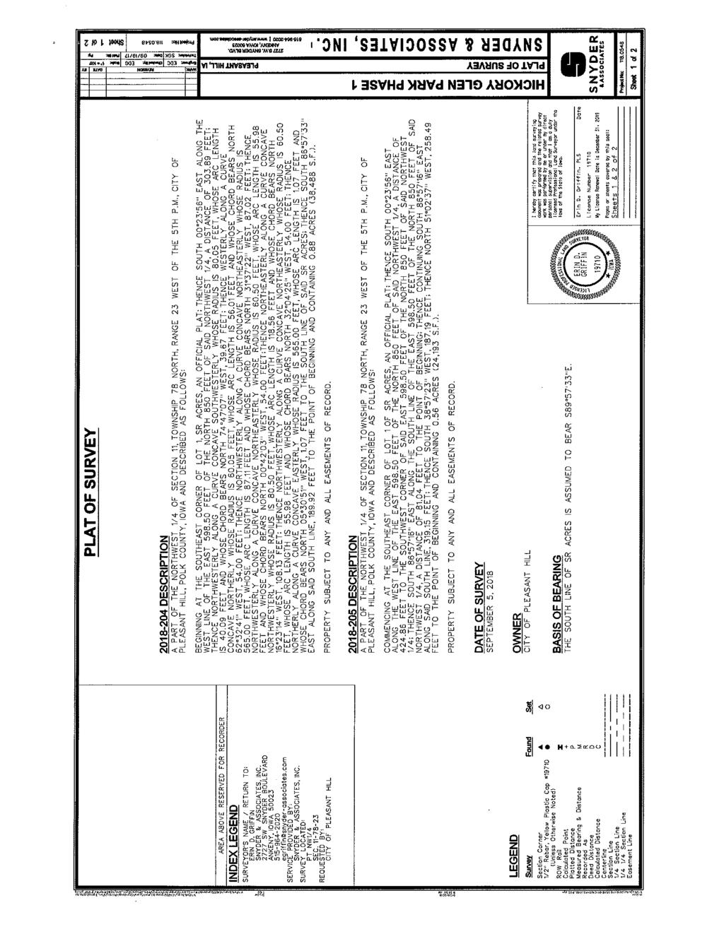
102 103
103 104
104 AGENDA ITEM: CITY OF PLEASANT HILL, IOWA CITY COUNCIL AGENDA COMMUNICATION DATE: December 18, 2018 TO: FROM: SUBJECT: Mayor and City Council RICK COURCIER, Parks & Recreation Manager Event Application Springtime Hill Climb 5K Run BACKGROUND: Ned Looney, Executive Director of Caring Hands, is planning a 5K run in Pleasant Hill called Springtime Hill Climb. This is the eighth year that this event has taken place in Pleasant Hill and the third year that Caring Hands will be the organization that will be coordinating the event. Caring Hands has been and will continue to work with city staff for assistance in planning the event. The event will be held on Saturday, April 6, with the run to start at 9 AM at Doanes Park. The route will remain the same as previous years with Pleasant Hill Boulevard and Oakwood Drive being closed for a short period during the event. Event organizers are planning for 200 participants to register for this event. ALTERNATIVES: Not approve the permit FINANCIAL CONSIDERATIONS: As part of being a sponsor, in previous years the City has waived the fee for use of the Doanes Park Youth Center and noise permit. There will be a need for emergency services expenses that will be billed to the organization. After expenses; all revenue will go to the Caring Hands Organization. RECOMMENDATION: Consider approval of the Springtime Hill Climb Event Application along with waiving the Doanes Park Youth Center and noise permit fees for April 6,
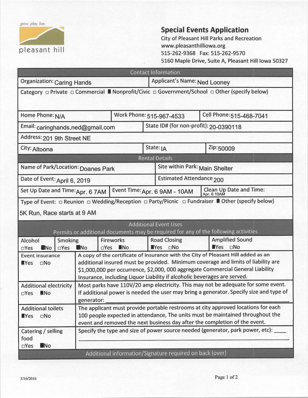
105 106

106 107

107 5K Route Mile 1 Mile 3 Mile 2 Start/Finish Line 108
108 APPLICATION FOR STREET CLOSING PERMIT To enable you to close or block off a street for a neighborhood or block party, the Pleasant Hill City Clerk and Police Chief must first give approval. A requirement for approval is proper notification of your neighbors of this request. Space is provided on the back of this form for their signatures. Each neighbor s signature will be considered as approving of this application. Thank you for your cooperation. APPLICANT S NAME: ADDRESS: PHONE: (HOME) (BUSINESS PHONE) (CELL PHONE) PURPOSE OF STREET CLOSURE: AREA TO BE BLOCKED OFF: DATE OF CLOSURE: TIME OF CLOSURE: DO YOU NEED STREET BARRICADES? ADDRESS WHERE BARRICADES SHOULD BE DROPPED OFF: Barricades will be picked up at the same location the next working day following street closure. For Office Personnel Only Date Submitted: Permit No. City Clerk s Approval/Denial: Police Dept. Approval/Denial: Copies to: Public Works Department Police Department City Clerk s Office Fire Department Revised

109 APPLICATION FOR SOUND PERMIT Fees: 1 day or less: $ through 7 days: $25.00 APPLICANT S NAME: ADDRESS: PHONE: PURPOSE FOR WHICH SOUND EQUIPMENT WILL BE USED: LOCATION WHERE EQUIPMENT WILL BE USED: DAY OF WEEK / DATE OF EVENT: TIMES OF DAY: GENERAL DESCRIPTION OF EQUIPMENT TO BE USED (VEHICLE LICENSE PLATE NUMBER, IF APPLICABLE): ANY OTHER INFORMATION REQUIRED BY THE CITY CLERK OR BUILDING INSPECTOR: Signature of Applicant For Office Use Only: Date Submitted cc: Public Works Dept. Fee Paid Police Dept. Fee Waived City Clerk s Office Permit No. Fire Dept. Police Dept. Approval/Denial City Clerk's Approval/Denial Revised
110 CITY OF PLEASANT HILL, IOWA CITY COUNCIL AGENDA COMMUNICATION DATE: DECEMBER 11, 2018 TO: FROM: SUBJECT: MAYOR & CITY COUNCIL MADELINE STURMS, AICP, CPM COMMUNITY DEVELOPMENT DIRECTOR PLEASANT HILL BLVD AND VANDALIA RD INTERSECTION IMPROVEMENT PROJECT OFFER TO PURCHASE EASEMENT IN REAL ESTATE AND ACCEPTANCE MIDAMERICAN ENERGY COMPANY BACKGROUND: The City of Pleasant Hill has been working with the City of Des Moines to plan, construct, and apply for funding for the Southeast Connector/Martin Luther King Jr. Parkway Extension as a transportation corridor connecting the Highway 5/65 Bypass to downtown Des Moines for over a decade. The City of Des Moines completed a new section of the roadway to extend to 30 th Street in The intersection improvements at Pleasant Hill Boulevard and Vandalia Road are under final engineering design. The roadway improvements require the acquisition of property for use in the construction of the project as well as for permanent right-of-way. The Council has previously authorized the acquisition of property needed for the project by gift, negotiation, or condemnation. Appraisals were conducted on the properties needed for right-of-way and a previous council action established the fair market value of the property as identified by the appraisals. Attached is a resolution which approves an offer to purchase easement in real estate and acceptance for permanent easement for storm sewer and surface water flowage and temporary easement for construction and construction related activities from MidAmerican Energy Company to complete the project. ALTERNATIVES: Not approve the resolution, however, the property is needed in order to construct the Pleasant Hill Blvd and Vandalia Rd Intersection Project.. FINANCIAL CONSIDERATIONS: Funds have been budgeted in the Capital Improvements Project fund. RECOMMENDATION: Consider approval of the attached resolution which approves the offer to purchase easement in real estate and acceptance from MidAmerican Energy Company. 111
111 RESOLUTION # A RESOLUTION APPROVING THE OFFER TO PURCHASE EASEMENT IN REAL ESTATE AND ACCEPTANCE FOR PLEASANT HILL BOULEVARD AND VANDALIA ROAD INTERSECTION IMPROVEMENT PROJECT FROM MIDAMERICAN ENERGY COMPANY WHEREAS, the City Council of the City of Pleasant Hill authorized the acquisition, by gift, negotiation, or condemnation, of the right-of-way required to construct the Pleasant Hill Boulevard and Vandalia Road Intersection Improvement Project; and WHEREAS, the properties have been appraised and the City has negotiated the acquisition of permanent easement for storm sewer and surface water flowage and temporary easement for construction and construction-related activities from MidAmerican Energy Company. NOW, THEREFORE, BE IT RESOLVED by the City Council of the City of Pleasant Hill, Iowa approves the attached Offer to Purchase Easement in Real Estate and Acceptance for Permanent Easement for Storm Sewer and Surface Water Flowage and Temporary easement for Construction and Construction-Related Activities from MidAmerican Energy Company for the for the Pleasant Hill Boulevard and Vandalia Road Intersection Improvement Project. ADOPTED December 18, Sara Kurovski, Mayor ATTEST: Dena Spooner, City Clerk/Finance Director 112
112 113
113 114
114 115
115 116
116 117
117 118
118 119

119 120
120 121
121 122
122 123
123 124
124 125
125 126
126 127
FLOODPLAIN MANAGEMENT ORDINANCE
 FLOODPLAIN MANAGEMENT ORDINANCE SECTION I - Statutory Authority, Findings of Fact and Purpose A. The Legislature of the State of Iowa has in Chapter 364, Code of Iowa, as amended, delegated the power to
ORDINANCE NO. 16 MONONA COUNTY FLOOD PLAIN MANAGEMENT ORDINANCE
 ORDINANCE NO. 16 MONONA COUNTY FLOOD PLAIN MANAGEMENT ORDINANCE SECTION I - Statutory Authority, Findings of Fact and Purpose A. The Legislature of the State of Iowa has in Chapter 335, Code of Iowa, as
Town of Alexandria. Floodplain Management Ordinance
 1 of 7 8/8/2009 4:56 PM Town of Alexandria Floodplain Management Ordinance SECTION 1 PURPOSE Certain areas of the Town of Alexandria, New Hampshire are subject to periodic flooding, causing serious damages
ORDINANCE NO
 ORDINANCE NO. 2017-01 AN ORDINANCE TO ADOPT THE GUTHRIE COUNTY, IOWA FLOODPLAIN MANAGEMENT ORDINANCE SETTING FORTH THE REGULATIONS GOVERNING THE ORDERLY LAND DEVELOPMENT FOR ALL THE UNINCORPORATED AREA
Flood Plain Management
 Ordinance No. 40 AN ORDINANCE establishing Flood Plain Management regulations in the un-incorporated area of Monroe County. The Legislature of the State of Iowa has in Chapter 335 Code of Iowa, as amended,
SIOUX COUNTY IOWA FLOODPLAIN MANAGEMENT ORDINANCE
 SIOUX COUNTY IOWA FLOODPLAIN MANAGEMENT ORDINANCE SIOUX COUNTY FLOODPLAIN MANAGEMENT ORDINANCE SECTION I Statutory Authority, Findings of Fact and Purpose A. The Legislature of the State of Iowa has in
(Chapter Flood Damage Prevention)
") Chapter 13.10 Flood Damage Prevention Section: 13.10.010 Purpose and Policy 13.10.020 Definitions 13.10.030 Applicability and Areas of Special Flood Hazard 13.10.040 Administration 13.10.050 Provisions
Chapter 13.10 Flood Damage Prevention Section: 13.10.010 Purpose and Policy 13.10.020 Definitions 13.10.030 Applicability and Areas of Special Flood Hazard 13.10.040 Administration 13.10.050 Provisions
CHAPTER 24 F FLOOD ZONE OVERLAY DISTRICT
 CHAPTER 24 OVERLAY DISTRICT SECTION 24.01 PURPOSE It is the intent of this district to apply special regulation to the use of land in those areas subject to periodic inundation. Such regulation is deemed
CHAPTER 3 - FLOOD PLAIN MANAGEMENT ORDINANCE OF DUBUQUE COUNTY, IOWA
 CHAPTER 3 - FLOOD PLAIN MANAGEMENT ORDINANCE OF DUBUQUE COUNTY, IOWA Adopted August 29, 1983 Amended June 4, 2001 Amended October 10, 2011 Amended August 12, 2013 Table of Contents Page Part 1 Introduction.................................................
LINCOLN COUNTY FLOOD DAMAGE PREVENTION ORDINANCE
 LINCOLN COUNTY FLOOD DAMAGE PREVENTION ORDINANCE SECTION 1.0 STATUTORY AUTHORIZATION, FINDINGS OF FACT, PURPOSE AND OBJECTIVES SECTION 2 DEFINITIONS SECTION 3.0 GENERAL PROVISIONS SECTION 4.0 ADMINISTRATION
CHAPTER XIX FLOOD DAMAGE PROTECTION. Article. 1 Definitions 2 General Provisions 3 Administration 4 Provisions for Flood Hazard Reduction
 CHAPTER XIX FLOOD DAMAGE PROTECTION Article 1 Definitions 2 General Provisions 3 Administration 4 Provisions for Flood Hazard Reduction CHAPTER XIX FLOOD DAMAGE PROTECTION Article 1 Definitions 19.0101
CHAPTER XVII. REGULATION OF FLOOD PLAIN STATUTORY AUTHORIZATION, FINDINGS OF FACT, PURPOSE AND OBJECTIVES
 CHAPTER XVII. REGULATION OF FLOOD PLAIN ARTICLE 1.0 STATUTORY AUTHORIZATION, FINDINGS OF FACT, PURPOSE AND OBJECTIVES 17.0101 STATUTORY AUTHORIZATION The Legislature of the State of North Dakota has in
Flood Hazard Zone. [Amended effective ; ; ; ; ; ]
![Flood Hazard Zone. [Amended effective ; ; ; ; ; ]](/thumbs/82/86423647.jpg "Flood Hazard Zone. [Amended effective ; ; ; ; ; ]") ARTICLE 110, Flood Hazard Zone [Added effective 4-24-1978] 118-1100. Flood Hazard Zone. [Amended effective 8-19-1986; 2-26-1993; 6-18-2010; 12-24- 2010; 7-8-2013; 7-25-2014] A. Purpose and intent. (1)
ARTICLE 110, Flood Hazard Zone [Added effective 4-24-1978] 118-1100. Flood Hazard Zone. [Amended effective 8-19-1986; 2-26-1993; 6-18-2010; 12-24- 2010; 7-8-2013; 7-25-2014] A. Purpose and intent. (1)
CHAPTER 16. ZONING AND PLANNING
 CHAPTER 16. ZONING AND PLANNING Article 1. Zoning Regulations Article 2. Floodplain Management Article 3. Subdivision Regulations Article 4. Comprehensive Land Use Plan ARTICLE 1. ZONING REGULATIONS 16-101.
The Onekama Township Flood Damage Prevention Ordinance of Onekama Township, Manistee County, Michigan was adopted by the Onekama ORDINANCE #4
 AN ORDINANCE The Onekama Township Flood Damage Prevention Ordinance of Onekama Township, Manistee County, Michigan was adopted by the Onekama Township Board at a regular meeting of its Township Board held
Section Floodplain Development Ordinance This ordinance, adopted pursuant to the authority of RSA 674:16, shall be known as the Town of Newport
 Section 212 - Floodplain Development Ordinance This ordinance, adopted pursuant to the authority of RSA 674:16, shall be known as the Town of Newport Floodplain Development Ordinance. The regulations and
SPECIAL PURPOSE FLOOD DAMAGE PREVENTION REGULATIONS for FAIRFIELD COUNTY
 SPECIAL PURPOSE FLOOD DAMAGE PREVENTION REGULATIONS for FAIRFIELD COUNTY Adopted September 7, 1995 Effective October 9, 1995 Flood Maps are available in the Fairfield County Regional Planning Commission
Title 15. Buildings, Construction, Addressing and Land Use
 Chapters: 15.05 Land Use Fees 15.10 Flood Damage Prevention 15.15 Building Numbering Title 15 Buildings, Construction, Addressing and Land Use 15-1 Lyons Municipal Code 15.05.040 Chapter 15.05 Land Use
SPECIAL PURPOSE FLOOD DAMAGE PREVENTION ORDINANCE. Adopted: June 24th, 1998
 SPECIAL PURPOSE FLOOD DAMAGE PREVENTION ORDINANCE Adopted: June 24th, 1998 SECTION 1.0 STATUTORY AUTHORIZATION, FINDINGS OF FACT PURPOSE AND OBJECTIVES 1.1 STATUTORY AUTHORIZATION ARTICLE XVIII, Section
CHAPTER 5 FLOOD DAMAGE PREVENTION. Statutory Authorization, Findings of Fact, Purpose, Methods, and Definitions
 CHAPTER 5 FLOOD DAMAGE PREVENTION Article A. Section 5.1 Section 5.2 Section 5.3 Section 5.4 Section 5.5 Article B. Statutory Authorization, Findings of Fact, Purpose, Methods, and Definitions Statutory
MANSFIELD TOWNSHIP BURLINGTON COUNTY ORDINANCE
 MANSFIELD TOWNSHIP BURLINGTON COUNTY ORDINANCE 2017-15 AN ORDINANCE TO AMEND THE CODE OF THE TOWNSHIP OF MANSFIELD BY DELETING AND REPEALING CHAPTER 22 THEREOF, ENTITLED FLOOD DAMAGE PREVENTION, AND REPLACING
ARTICLE 18 TABLE OF CONTENTS TO THE FLOODPLAIN MANAGEMENT REGULATIONS
 Table of Contents Valley Center Floodplain Ordinance ARTICLE 18 TABLE OF CONTENTS TO THE FLOODPLAIN MANAGEMENT REGULATIONS Chapter 18.01 STATUTORY AUTHORIZATION, FINDINGS OF FACT & PURPOSES...1 18.01.01
ORDINANCE NO TOWNSHIP OF EAST WINDSOR COUNTY OF MERCER
 ORDINANCE NO. 2016-07 TOWNSHIP OF EAST WINDSOR COUNTY OF MERCER AN ORDINANCE REPEALING SECTION 22-4: FLOOD DAMAGE PREVENTION CODE, OF THE REVISED GENERAL ORDINANCES OF THE TOWNSHIP OF EAST WINDSOR AND
ARTICLE 14 FLOODPLAIN MANAGEMENT
 ARTICLE 14 FLOODPLAIN MANAGEMENT 14.1 Purpose and Establishment Certain areas of the Town of Buxton, Maine are subject to periodic flooding, causing serious damages to properties within these areas. Relief
ORDINANCE NO. 992 CITY OF OCEAN SHORES, WASHINGTON
 CITY OF OCEAN SHORES, WASHINGTON ORDINANCE NO. 992 AN EMERGENCY ORDINANCE OF THE CITY COUNCIL OF THE CITY OF OCEAN SHORES, WASHINGTON, AMENDING ORDINANCE NO. 990 AND OCEAN SHORES MUNICIPAL CODE CHAPTER
ORDINANCE # ARTICLE I STATUTORY AUTHORIZATION, FINDINGS OF FACT, PURPOSE AND METHODS
 60.3 (b) FLOOD DAMAGE PREVENTION ORDINANCE ORDINANCE #2009-07 ARTICLE I STATUTORY AUTHORIZATION, FINDINGS OF FACT, PURPOSE AND METHODS SECTION A. STATUTORY AUTHORIZATION The Legislature of the State of
ORDINANCE NO (1123)
") ORDINANCE NO. 2013-08 (1123) ORDINANCE OF THE BOROUGH OF LAVALLLETTE, COUNTY OF OCEAN, STATE OF NEW JERSEY, AMENDING AND SUPPLEMENTING CHAPTER 31, ENTITLED FLOOD HAZARD AREAS, OF THE REVISED GENERAL ORDINANCES
ORDINANCE NO. 2013-08 (1123) ORDINANCE OF THE BOROUGH OF LAVALLLETTE, COUNTY OF OCEAN, STATE OF NEW JERSEY, AMENDING AND SUPPLEMENTING CHAPTER 31, ENTITLED FLOOD HAZARD AREAS, OF THE REVISED GENERAL ORDINANCES
ORDINANCE NO
 ORDINANCE NO. 161-95 AN ORDINANCE ENACTING A DOÑA ANA COUNTY FLOOD DAMAGE PREVENTION ORDINANCE, CITING STATUTORY AUTHORIZATION AND FINDINGS OF FACT, ESTABLISHING THE PURPOSE, METHODS, SHORT TITLE, DEFINITIONS,
Conditional Use Permit in the Floodway Overlay District Application Packet
 Conditional Use Permit in the Floodway Overlay District Application Packet 1. Application Packet. Be sure to complete and submit all the required materials that are a part of this Application Packet. Failure
TUSCARAWAS COUNTY FLOOD DAMAGE REDUCTION REGULATIONS
 TUSCARAWAS COUNTY FLOOD DAMAGE REDUCTION REGULATIONS 2010 Approved for adoption by ODNR 5/11/07 Adopted by the Board of Tuscarawas County Commissioners Date: October 1, 2007 Resolution No: 736-2007 Revised
DEPARTMENT OF NATURAL RESOURCES FLOOD PLAIN CHAPTER 31, ARTICLE 10
 STATE OF NEBRASKA DEPARTMENT OF NATURAL RESOURCES FLOOD PLAIN CHAPTER 31, ARTICLE 10 DECEMBER 2003 TABLE OF CONTENTS CHAPTER 31, ARTICLE 10 FLOOD PLAIN Section Page 31-1001 Legislative findings; purpose
CARTER COUNTY, OKLAHOMA FLOODPLAIN BOARD REGULATIONS ARTICLE I STATUTORY AUTHORIZATION, FINDINGS OF FACT, PURPOSE AND METHODS
 CARTER COUNTY, OKLAHOMA FLOODPLAIN BOARD REGULATIONS ARTICLE I STATUTORY AUTHORIZATION, FINDINGS OF FACT, PURPOSE AND METHODS SECTION A. STATUTORY AUTHORIZATION The Legislature of the State of Oklahoma
SECTION 30- FP FLOOD PLAIN DISTRICT
 SECTION 30- FP FLOOD PLAIN DISTRICT This zoning district is created to be appended to or overlaid on another primary zoning district for the purpose of meeting the needs of the watercourses and drain ways
ORDINANCE NO. 13 Series 2001
 ORDINANCE NO. 13 Series 2001 AN ORDINANCE REPEALING AND READOPTING WITH CHANGES CHAPTER 3 OF TITLE 10 OF THE BRECKENRIDGE TOWN CODE. KNOWN AS THE "BRECKENRIDGE FLOOD DAMAGE PREVENTION ORDINANCE" BE IT
OUTLINE STATUTORY AUTHORIZATION. FINDINGS OF FACT. PURPOSE AND METHODS... 1B
 MASTER FLOOD HAZARD PREVENTION ORDINANCE OUTLINE ARTICLE I Section A Section B Section C Section D STATUTORY AUTHORIZATION. FINDINGS OF FACT. PURPOSE AND METHODS... 1B Statutory Authorization... 1B Findings
ORDINANCE NO. 990 CITY OF OCEAN SHORES, WASHINGTON. NOW, THEREFORE, the City Council of the Ocean Shores does hereby ordain as follows:
 CITY OF OCEAN SHORES, WASHINGTON ORDINANCE NO. 990 AN ORDINANCE OF THE CITY COUNCIL OF THE CITY OF OCEAN SHORES, WASHINGTON, AMENDING OCEAN SHORES MUNICIPAL CODE CHAPTER 15.36 FLOOD DAMAGE PREVENTION WHEREAS,
CHAPTER 1313 Flood Damage Prevention Statutory authorization Exemption from filing a Findings
 11 CHAPTER 1313 Flood Damage Prevention 1313.01 Statutory authorization. 1313.02 Findings of fact. 1313.03 Statement of purpose. 1313.04 Methods of reducing flood losses. 1313.05 Lands to which these regulations
CITY OF OAK RIDGE KAUFMAN COUNTY, TEXAS ORDINANCE FLOODPLAIN MANAGEMENT
 CITY OF OAK RIDGE KAUFMAN COUNTY, TEXAS ORDINANCE 32-10 FLOODPLAIN MANAGEMENT ARTICLE I STATUTORY AUTHORIZATION, FINDINGS OF FACT, PURPOSE AND METHODS SECTION A. STATUTORY AUTHORIZATION The Legislature
TOWN OF SPAFFORD LOCAL LAW 3 OF THE YEAR 2016
 TOWN OF SPAFFORD LOCAL LAW 3 OF THE YEAR 2016 A Local Law Amending Local Law No. 2 of the Year 1990 to repeal the existing language and replace it with the following language relating to Flood Damage Prevention
TITLE 14 ZONING AND LAND USE CONTROL CHAPTER 1 MUNICIPAL PLANNING COMMISSION
 14-1 TITLE 14 ZONING AND LAND USE CONTROL CHAPTER 1. MUNICIPAL PLANNING COMMISSION. 2. ZONING ORDINANCE. 3. FLOOD DAMAGE PREVENTION ORDINANCE. CHAPTER 1 MUNICIPAL PLANNING COMMISSION SECTION 14-101. Creation
FLOOD DAMAGE REDUCTION RESOLUTION GREENE COUNTY, OHIO
 FLOOD DAMAGE REDUCTION RESOLUTION GREENE COUNTY, OHIO SECTION 101.01: GENERAL PROVISIONS 101.01.1 Statutory Authorization This resolution is adopted pursuant to authorization contained in Sections 307.37
CHAPTER 1108 Flood Damage Protection
 CHAPTER 1108 Flood Damage Protection 1108.01 General Provisions. 1108.02 Definitions. 1108.03 Administration. 1108.04 Use and development standards for flood hazard reduction. 1108.05 Appeals and variances.
FLOOD DAMAGE PREVENTION COURT ORDER ARTICLE I STATUTORY AUTHORIZATION, FINDINGS OF FACT, PURPOSE AND METHODS
 FLOOD DAMAGE PREVENTION COURT ORDER ARTICLE I STATUTORY AUTHORIZATION, FINDINGS OF FACT, PURPOSE AND METHODS SECTION A. STATUTORY AUTHORIZATION The Legislature of the State of Texas has in the Flood Control
ORDINANCE NO
 ORDINANCE NO. 1715.08 AN ORDINANCE ADOPTING A FLOOD DAMAGE PREVENTION ORDINANCE FOR THE CITY OF SAN ELIZARIO; ESTABLISHING FLOOD CONTROL REGULATIONS; CREATING A MISDEMEANOR OFFENSE PUNISHABLE BY A FINE
SPECIAL PURPOSE FLOOD DAMAGE REDUCTION RESOLUTION FOR PICKAWAY COUNTY, OHIO
 SPECIAL PURPOSE FLOOD DAMAGE REDUCTION RESOLUTION FOR PICKAWAY COUNTY, OHIO Effective December 7, 2012 Pickaway County Board of Commissioners Glenn D. Reeser Jay H. Wippel Ula Jean Metzler Terry L. Frazier,
NOTICE
 www.ketteringoh.org NOTICE This City of Kettering Code section is not the official version and is provided only for the convenience of the public. The only official version of the City of Kettering Code
TITLE 14 ZONING AND LAND USE CONTROL CHAPTER 1 MUNICIPAL PLANNING COMMISSION
 14-1 TITLE 14 ZONING AND LAND USE CONTROL CHAPTER 1. MUNICIPAL PLANNING COMMISSION. 2. ZONING ORDINANCE. 3. FLOOD DAMAGE PREVENTION. CHAPTER 1 MUNICIPAL PLANNING COMMISSION SECTION 14-101. Creation and
The Board of Supervisors of the County of Riverside ordains as follows:
 ORDINANCE NO. 458 (AS AMENDED THROUGH 458.13) AN ORDINANCE OF THE COUNTY OF RIVERSIDE AMENDING ORDINANCE NO. 458 REGULATING FLOOD HAZARD AREAS AND IMPLEMENTING THE NATIONAL FLOOD INSURANCE PROGRAM The
CHAPTER 47. FLOODPLAIN MANAGEMENT REGULATIONS. Article I. Statutory Authorization, Findings of Fact, Purpose and Methods. Article II. Definitions.
 CHAPTER 47. FLOODPLAIN MANAGEMENT REGULATIONS. Article I. Statutory Authorization, Findings of Fact, Purpose and Methods. Sec. 47 Sec. 47-1. Sec. 47-2. Sec. 47-3. Sec. 47-4. Statutory authorization. Findings
CHAPTER 109 NATURAL RESOURCES AND ENVIRONMENTAL PROTECTION. ARTICLE I. Flood Damage Prevention In General
 Sec. 109-1. - Authorization. CHAPTER 109 NATURAL RESOURCES AND ENVIRONMENTAL PROTECTION ARTICLE I. Flood Damage Prevention In General Article IX, Section II of the Constitution of the State of Georgia
THIS ARTICLE HAS BEEN COMPLETELY REWRITTEN. Chapter CRITICAL AREAS. Article XIX. Flood Hazard Areas. Article XIX. Flood Hazard Areas
 THIS ARTICLE HAS BEEN COMPLETELY REWRITTEN Chapter 18.55 CRITICAL AREAS Sections: Article XIX. Flood Hazard Areas 18.55.700 Purpose. 18.55.705 Definitions 18.55.707 Lands to which this article applies.
FLOODPLAIN MANAGEMENT ORDINANCE
 FLOODPLAIN MANAGEMENT ORDINANCE FOR THE TOWN OF MARIAVILLE, MAINE Enacted April 4. 1997 STATEMENT OF PURPOSE AND INTENT Certain areas of the Town of Mariaville, Maine are subject to periodic flooding.
Date of Review: 11/6/2015 Reviewer: RCQ/LMC STATE
 FINAL Florida Review Checklist: NFIP & FBC & Revised Model Ordinance (January 15, 2013d) Ordinance Citation: Model FPM regulations and 5 th Edition FBC : All Zones Date of Review: 11/6/2015 Reviewer: RCQ/LMC
Restrict or prohibit uses which are dangerous to health, safety and property due to water or erosion or in flood heights or velocities;
 CODE OF ORDINANCES, CITY OF BRISTOL, CONNECTICUT APPENDIX D, FLOOD DAMAGE PREVENTION (adopted on August 12, 2008) SECTION 1 - STATUTORY AUTHORIZATION, FINDING OF FACT, PURPOSE AND OBJECTIVES 1.1. Statutory
Flood Damage Prevention
 Flood Damage Prevention Town of Berkshire Local Law No. 1 of the year 1989 A local law for flood damage prevention as authorized by the New York State Constitution, Article IX, Section 2, and Environmental
(Ord. No. 5068, )
") ARTICLE VIII. - FLOODPLAIN MANAGEMENT AND FLOOD DAMAGE PREVENTION [5] Footnotes: --- (5) --- Editor's note Ord. No. 5068, adopted May 23, 1995, repealed and replaced flood damage control provisions formerly
ARTICLE VIII. - FLOODPLAIN MANAGEMENT AND FLOOD DAMAGE PREVENTION [5] Footnotes: --- (5) --- Editor's note Ord. No. 5068, adopted May 23, 1995, repealed and replaced flood damage control provisions formerly
FLOOD DAMAGE PREVENTION
 ARTICLE 30 FLOOD DAMAGE PREVENTION 30.01 General Provisions... 30-1 30.02 Administration... 30-2 30.03 Provisions for Flood Hazard Reduction... 30-7 30.01 General Provisions 30.01.01 Lands to Which This
Waupaca County. Floodplain. Ordinance
 Waupaca County Floodplain Ordinance Ordinance No. 18 Floodplain Ordinance was adopted by the Waupaca County Board on July 28, 1977. Amend Ordinance #87-16-01 to repeal and re-enact the Waupaca County Floodplain
TITLE 14 ZONING AND LAND USE CONTROL CHAPTER 1 MUNICIPAL PLANNING COMMISSION
 Change 2, December 8, 2014 14-1 TITLE 14 ZONING AND LAND USE CONTROL CHAPTER 1. MUNICIPAL PLANNING COMMISSION. 2. FLOOD DAMAGE PREVENTION ORDINANCE. 3. SIGN ORDINANCE. CHAPTER 1 MUNICIPAL PLANNING COMMISSION
A. To prevent unwise development from increasing flood or drainage hazards to others.
 BOONE COUNTY FLOOD HAZARD AREA Ordinance No. 94 14 (September 19, 1994) Amended Ordinance No. 98 2 (April 6, 1998) Amended Ordinance No. 02 6 (June 3, 2002) SECTION 1 STATUTORY AUTHORIZATION The Indiana
MODEL FLOODPLAIN MANAGEMENT / FLOOD DAMAGE PREVENTION ORDINANCE
 MODEL FLOODPLAIN MANAGEMENT / FLOOD DAMAGE PREVENTION ORDINANCE Description: Floodplain management involves the designation of flood-prone areas and the managing of their uses. It is also aimed at minimizing
MN Floodplain Management Ordinance: 2012 City of Glyndon, Minnesota Two Districts - One-Map Format
 MN Floodplain Management Ordinance: 2012 City of Glyndon, Minnesota Two Districts - One-Map Format TABLE OF CONTENTS PAGE SECTION 1.0 STATUTORY AUTHORIZATION, FINDINGS OF FACT AND PURPOSE 1 1.1 Statutory
For public hearing by the Town Council and Planning Commission March 24, 2014
 AN ORDINANCE TO AMEND SECTION 17.0 FLOOD HAZARD OVERLAY DISTRICT FH OF THE ZONING ORDINANCE OF THE TOWN OF SCOTTSVILLE, VIRGINIA BE IT ORDAINED by the Town Council of the Town of Scottsville, Virginia,
FLOODPLAIN MANAGEMENT ORDINANCE FOR THE TOWN OF WELD, MAINE
 FLOODPLAIN MANAGEMENT ORDINANCE FOR THE TOWN OF WELD, MAINE ENACTED: May 29, 2008 Date EFFECTIVE: May 29, 2008 Date CERTIFIED BY: Carol J. Cochran Name Town Clerk Title Affix Seal 60.3(b) Printed 3/11/08
RD:VMT:NGA ORD. NO /3/09 ORDINANCE NO
 ORDINANCE NO. 28512 AN ORDINANCE OF THE CITY OF SAN JOSE AMENDING CHAPTER 17.08 OF TITLE 17 OF THE SAN JOSE MUNICIPAL CODE TO UPDATE THE CITY S SPECIAL FLOOD HAZARD REGULATIONS WHEREAS, the Council of
FLOOD-RESISTANT CONSTRUCTION
 FLOOD-RESISTANT CONSTRUCTION The provisions contained in this appendix are not mandatory unless specifically referenced in the adopting ordinance. SECTION G101 ADMINISTRATION G101.1 Purpose. The purpose
Meeting Minutes Lodi Township Planning Commission November 27, 2012 Lodi Township Hall 3755 Pleasant Lake Road Ann Arbor, MI 48103
 Meeting Minutes Lodi Township Planning Commission November 27, 2012 Lodi Township Hall 3755 Pleasant Lake Road Ann Arbor, MI 48103 1) Call to Order The meeting was called to order by Chair Jack Steeb at
Law # 1 of 2008 SECTION 1.0 STATUTORY AUTHORIZATION AND PURPOSE
 Law # 1 of 2008 A local law for Flood Damage Prevention as authorized by the New York State Constitution, Article IX, Section 2, and Environmental Conservation Law, Article 36 1.1 FINDINGS SECTION 1.0
TOWN OF JEWETT LOCAL LAW # OF 2008 FLOOD PREVENTION LOCAL LAW STATUTORY AUTHORIZATION AND PURPOSE
 TOWN OF JEWETT LOCAL LAW # OF 2008 FLOOD PREVENTION LOCAL LAW SECTION 1. STATUTORY AUTHORIZATION AND PURPOSE 1.1 FINDINGS The Town Board of the Town Jewett finds that the potential and/or actual damages
ORDINANCE NO
 ORDINANCE NO. 11-311 AN ORDINANCE OF THE CITY OF MONTROSE, SD, AMENDING THE REVISED MUNICIPAL ORDINANCES OF THE CITY BY AMENDING CHAPTER 9.04, FLOOD INSURANCE. BE IT ORDAINED BY THE CITY OF MONTROSE, SD:
Floodplain Management
 Chapter VIII Floodplain Management 1. Statutory Authorization, Findings of Fact, and Purpose A. Statutory Authorization The legislature of the State of Minnesota has, in Minnesota Statutes, chapters 103F
Section Flood Plain Management Districts
 1370.05 FLOOD PLAIN MANAGEMENT DISTRICTS Subd. 1 Statutory Authorization: The legislature of the State of Minnesota has, in Minnesota Statutes Chapter 103F and Chapter 462, delegated the responsibility
Flood Plain Overlay District. Section Statutory Authorization, Findings of Fact and Purpose.
 Article X. Flood Plain Overlay District. Section 20-171. Statutory Authorization, Findings of Fact and Purpose. (a) Statutory Authorization. The legislature of the State of Minnesota has, in Minnesota
Floodway and Flood Plain Districts
 Chapter 6 Floodway and Flood Plain Districts 6.010 - Purpose To establish land use regulations for properties situated in floodways and flood plain lands so as to: A. Minimize property damage from flood
WOOD COUNTY ORDINANCE #703 FLOODPLAIN ZONING ORDINANCE TABLE OF CONTENTS
 WOOD COUNTY ORDINANCE #703 FLOODPLAIN ZONING ORDINANCE TABLE OF CONTENTS 703.01 STATUTORY AUTHORIZATION, FINIDNG OF FACT AND STATEMENT OF PURPOSE 703-1 (1) Statutory Authorization. 703-1 (2) Finding of
CITY OF MUSKEGO CHAPTER 14 - FLOODPLAIN ZONING ORDINANCE (Ord. # )
") CITY OF MUSKEGO CHAPTER 14 - FLOODPLAIN ZONING ORDINANCE (Ord. #1340 2-20-2014) 1.0 STATUTORY AUTHORIZATION, FINDING OF FACT, STATEMENT OF PURPOSE, TITLE AND GENERAL PROVISIONS.... 1 1.1 STATUTORY AUTHORIZATION...
CITY OF MUSKEGO CHAPTER 14 - FLOODPLAIN ZONING ORDINANCE (Ord. #1340 2-20-2014) 1.0 STATUTORY AUTHORIZATION, FINDING OF FACT, STATEMENT OF PURPOSE, TITLE AND GENERAL PROVISIONS.... 1 1.1 STATUTORY AUTHORIZATION...
City of Ferndale Floodplain Management Ordinance Page 1 of 18 ORDINANCE 08-02
 City of Ferndale Floodplain Management Ordinance 08-02 Page 1 of 18 ORDINANCE 08-02 AN ORDINANCE OF THE CITY COUNCIL OF THE CITY OF FERNDALE ESTABLISHING THE MINIMUM REQUIREMENTS OF THE NATIONAL FLOOD
CITY OF CAMBRIDGE FLOODPLAIN MANAGEMENT CHAPTER 7 (GRADING, EROSION AND SEDIMENT CONTROL)
") CITY OF CAMBRIDGE FLOODPLAIN MANAGEMENT CHAPTER 7 (GRADING, EROSION AND SEDIMENT CONTROL) City of Cambridge, MD Floodplain Management Ordinance (Tidal): May, 2011 1 City of Cambridge, Maryland Floodplain
CITY OF CAMBRIDGE FLOODPLAIN MANAGEMENT CHAPTER 7 (GRADING, EROSION AND SEDIMENT CONTROL) City of Cambridge, MD Floodplain Management Ordinance (Tidal): May, 2011 1 City of Cambridge, Maryland Floodplain
RENVILLE COUNTY LAND USE ORDINANCE CHAPTER NINE FLOOD PLAIN REGULATIONS SECTION 1. STATUTORY AUTHORIZATION, FINDINGS OF FACT, AND STATEMENT OF PURPOSE
 RENVILLE COUNTY LAND USE ORDINANCE CHAPTER NINE FLOOD PLAIN REGULATIONS SECTION 1. STATUTORY AUTHORIZATION, FINDINGS OF FACT, AND STATEMENT OF PURPOSE 1. Statutory Authorization. The legislature of the
Chapter 8.01 FLOOD DAMAGE PREVENTION
 8.01.010 Chapter 8.01 FLOOD DAMAGE PREVENTION Sections: 8.01.010 Statutory authorization. 8.01.011 Findings of fact. 8.01.012 Statement of purpose. 8.01.013 Methods of reducing flood losses. 8.01.020 Definitions.
City of Fort Atkinson
 City of Fort Atkinson FLOODPLAIN ZONING ORDINANCE With Flood Storage Modifications February 4, 2015 ADOPTED by Fort Atkinson City Council November 18, 2014 ORDINANCE NO. 725 The City Council of the City
TITLE XV: LAND USAGE 151. SUBDIVISIONS
 TITLE XV: LAND USAGE Chapter 150. FLOOD 151. SUBDIVISIONS 152. ZONING 1 2 Parkston - Land Usage CHAPTER 150: FLOOD Section General Provisions 150.01 Statutory authorization 150.02 Findings of fact 150.03
VILLAGE OF CORRALES ORDINANCE NO
 VILLAGE OF CORRALES ORDINANCE NO. 08-003 AN ORDNANCE AMENDING VARIOUS SECTIONS OF CHAPTER 18, ARTICLE IV OF THE CODE OF ORDNANCES OF THE VILLAGE OF CORRALES THE "VILLAGE", BEING ORDINANCE NO. 115, ADOPTED
Flood Hazard Development Permit Application & Permit Forms. For Communities with Coastal Velocity Zones [60.3(e)] CONTENTS
![Flood Hazard Development Permit Application & Permit Forms. For Communities with Coastal Velocity Zones [60.3(e)] CONTENTS](/thumbs/76/74346075.jpg "Flood Hazard Development Permit Application & Permit Forms. For Communities with Coastal Velocity Zones [60.3(e)] CONTENTS") Flood Hazard Development Permit Application & Permit Forms For Communities with Coastal Velocity Zones [60.3(e)] CONTENTS 1. Decision Tree 2. Flood Hazard Development Permit Application 3. Flood Hazard
Flood Hazard Development Permit Application & Permit Forms For Communities with Coastal Velocity Zones [60.3(e)] CONTENTS 1. Decision Tree 2. Flood Hazard Development Permit Application 3. Flood Hazard
Art. I. Art. n. Art. III.
 Chapter 8 FLOOD DAMAGE PREVENTION AND CONTROL* Art. I. Art. n. Art. III. In General, 8-1-8-20 Administration, 8-21-8-30 Provisions for Flood Hazard Reduction, 8-31-8-37 ARTICLE I. IN GENERAL Sec. 8-1.
ORDINANCE NO. THE CITY COUNCIL OF THE CITY OF BISHOP, STATE OF CALIFORNIA DOES ORDAIN AS FOLLOWS:
 ORDINANCE NO. AN ORDINANCE OF THE CITY COUNCIL OF THE CITY OF BISHOP, STATE OF CALIFORNIA, REPEALING BISHOP MUNICIPAL CODE CHAPTER 15.20 ENTITLED FLOOD DAMAGE PREVENTION AND ORDINANCE NOS. 432 AND 450,
FLOODPLAIN MANAGEMENT ORDINANCE CONTENTS
 FLOODPLAIN MANAGEMENT ORDINANCE CONTENTS ARTICLE PAGE I. PURPOSE AND ESTABLISHMENT... 2 II. PERMIT REQUIRED... 2 III. APPLICATION FOR PERMIT... 2 IV. APPLICATION FEE AND EXPERT'S FEE... 4 V. REVIEW STANDARDS
FLOODPLAIN MANAGEMENT ORDINANCE FOR THE TOWN OF SUMNER, MAINE
 FLOODPLAIN MANAGEMENT ORDINANCE FOR THE TOWN OF SUMNER, MAINE ENACTED: June 23, 2009 Date EFFECTIVE: June 24, 2009 Date CERTIFIED BY: Susan C Runes Susan C. Runes Susan C. Runes Clerk, Town of Sumner Affix
Chapter FLOODPLAIN MANAGEMENT
 Chapter 16.20 FLOODPLAIN MANAGEMENT Sections: 16.20.010 Statutory authorization. 16.20.020 Findings of fact. 16.20.030 Statement of purpose. 16.20.035 Methods of reducing flood losses. 16.20.040 Definitions.
CITY OF AUSTELL DESIGN AND CONSTRUCTION STANDARDS LAND DEVELOPMENT ORDINANCES
 CITY OF AUSTELL DESIGN AND CONSTRUCTION STANDARDS LAND DEVELOPMENT ORDINANCES Land Development Ordinances Section 8 CITY OF AUSTELL DESIGN AND CONSTRUCTION STANDARDS LAND DEVELOPMENT ORDINANCES Article
TOWNSHIP OF BASS RIVER Ordinance 2017-
 TOWNSHIP OF BASS RIVER Ordinance 2017- AN ORDINANCE OF THE TOWNSHIP OF BASS RIVER AMENDING CHAPTER 15.24 FLOOD HAZARD AREAS OF THE REVISED ORDINANCES OF BASS RIVER TOWNSHIP WHEREAS, the Bass River Township
2014 UPDATED YOLO COUNTY CODE. Title 8 LAND DEVELOPMENT CHAPTER 4: FLOOD PROTECTION. Article 1: Findings of Fact, Purpose and Methods
 2014 UPDATED YOLO COUNTY CODE Title 8 LAND DEVELOPMENT CHAPTER 4: FLOOD PROTECTION Article 1: Findings of Fact, Purpose and Methods Sec. 8-4.101 Findings of fact The special flood hazard areas of Yolo
Oxford Floodplain Management Ordinance
 Table of Contents SECTION 1.0 GENERAL PROVISIONS...1 1.1 Findings...1 1.2 Statutory Authorization...1 1.3 Statement of Purpose...1 1.4 Areas to Which These Regulations Apply...2 1.5 Basis for Establishing
CHAPTER 21 THE OCONTO COUNTY FLOODPLAIN ORDINANCE TABLE OF CONTENTS REVISED: 03/21/2019
 CHAPTER 21 THE OCONTO COUNTY FLOODPLAIN ORDINANCE TABLE OF CONTENTS REVISED: 03/21/2019 21.100 Statutory Authorization, Finding of Fact, Statement Of Purpose, Title And General Provisions 21.200 General
11. FLOODPLAIN MANAGEMENT REGULATIONS
 11. FLOODPLAIN MANAGEMENT REGULATIONS 11.1 STATUTORY AUTHORIZATION AND PURPOSE A. STATUTORY AUTHORIZATION The Legislature of the State of Connecticut has delegated in Title 7, Chapter 98, Section 7-148(c)(7)(A),
TOWN OF BRIDGTON FLOODPLAIN MANAGEMENT ORDINANCE TABLE OF CONTENTS I PURPOSE AND ESTABLISHMENT... 2 II PERMIT REQUIRED... 2
 TOWN OF BRIDGTON FLOODPLAIN MANAGEMENT ORDINANCE TABLE OF CONTENTS ARTICLE PAGE I PURPOSE AND ESTABLISHMENT... 2 II PERMIT REQUIRED... 2 III APPLICATION FOR PERMIT... 3 IV APPLICATION FEE AND EXPERT'S
YOLO COUNTY ZONING CODE TITLE 8 LAND DEVELOPMENT CHAPTER 4: FLOOD PROTECTION. Article 1: Findings of Fact, Purpose and Methods
 YOLO COUNTY ZONING CODE TITLE 8 LAND DEVELOPMENT CHAPTER 4: FLOOD PROTECTION Article 1: Findings of Fact, Purpose and Methods Sec. 8-4.101 Statutory authorization The Legislature of the State of California
LUZERNE COUNTY ZONING ORDINANCE TEXT AMENDMENTS FLOOD PLAIN MANAGEMENT
 LUZERNE COUNTY ZONING ORDINANCE TEXT AMENDMENTS FLOOD PLAIN MANAGEMENT Eliminate in Article 11 DEFINITIONS The definitions of Flood, Flood- Fringe, Floodway, One Hundred Year Flood and One Hundred (100)
ARTICLE I. STATUTORY AUTHORIZATION, FINDINGS OF FACT, PURPOSE AND METHODS
 Chapter 7 FLOOD DAMAGE PREVENTION* *Editor's note: An Ord. of Sept. 1, 1998, amended former Ch. 7, Arts. I--VI, in its entirety to read as herein set out. Former Ch. 7 pertained to similar subject matter
ORDINANCE NO. 641-C BE IT ORDAINED BY THE CITY COUNCIL OF THE CITY OF SOUTHLAKE, TEXAS: ARTICLE I
 ORDINANCE NO. 641-C AN ORDINANCE PROVIDING FOR THE CITY OF SOUTHLAKE, TEXAS ADOPTING REGULATIONS DESIGNED TO MINIMIZE FLOOD LOSSES; ESTABLISHING PROVISIONS FOR FLOOD HAZARD REDUCTION; ADOPTING THE FLOOD