Planning Commission Hearing Date: 1/2/2018 Board of County Commissioners Hearing Date 1/23/2018
|
|
|
- Myles McKinney
- 5 years ago
- Views:
Transcription

1 COMMISSIONERS: DARRYL GLENN (PRESIDENT) MARK WALLER (PRESIDENT PRO TEMPORE) STAN VANDERWERF LONGINOS GONZALEZ PEGGY LITTLETON PLANNING AND COMMUNITY DEVELOPMENT DEPARTMENT CRAIG DOSSEY, EXECUTIVE DIRECTOR TO: FROM: El Paso County Planning Commission Jim Egbert, Chair Kari Parsons, PM/Planner II Jeff Rice, PE, Engineer III Craig Dossey, Executive Director RE: OWNER: Project File #: PUDSP Project Name: Lorson Ranch East Planned Unit Development/ Preliminary Plan Parcel Nos.: , , , , , , , , , , , and REPRESENTATIVE: Lorson Conservation Invest I, LLLP. Lorson, LLC. Nominee Eagle Development Company Murray Fountain, LLC. 212 N. Wasatch Ave., Suite 301 Colorado Springs, CO Thomas and Thomas Jason Alwine 702 N. Tejon Street Colorado Springs, CO Commissioner District: 4 Planning Commission Hearing Date: 1/2/2018 Board of County Commissioners Hearing Date 1/23/2018 EXECUTIVE SUMMARY A request by Lorson Conservation Invest I, LLLP, Lorson, LLC Nominee, Eagle Development Company, and Murray Fountain, LLC, for approval of a combined planned unit development (PUD)/preliminary plan for the Lorson Ranch East PUD (Planned Unit Development) Development Plan and preliminary plan. The twelve parcels, totaling 2880 INTERNATIONAL CIRCLE, SUITE 110 COLORADO SPRINGS, CO PHONE: (719) FAX: (719)
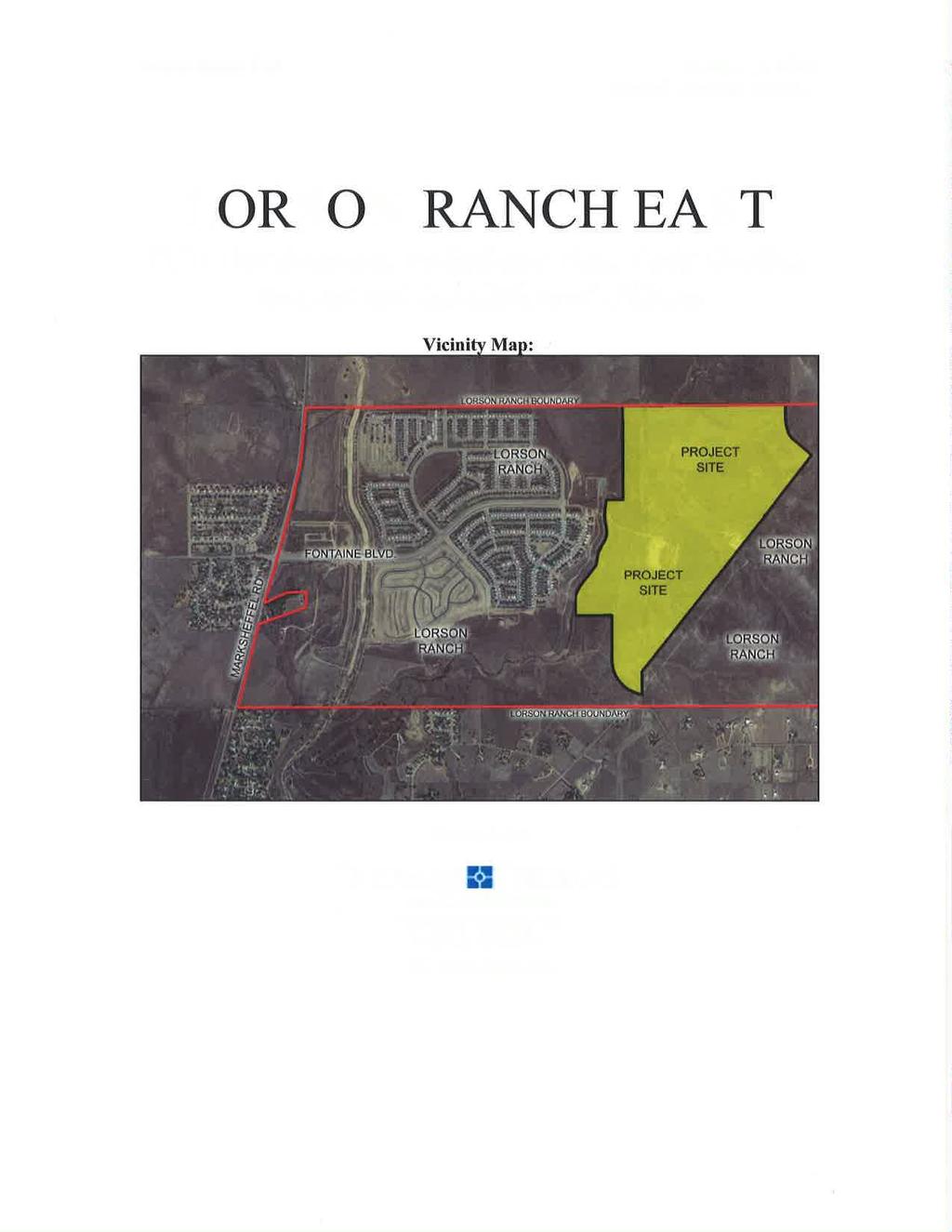
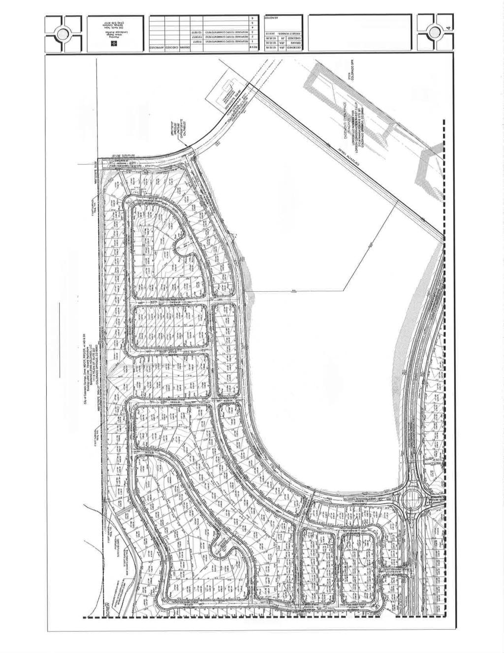
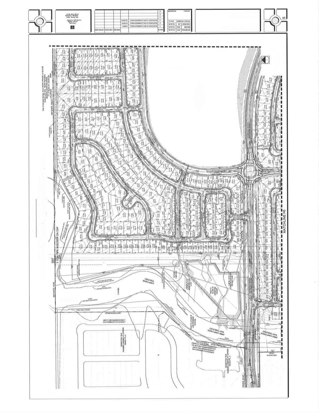
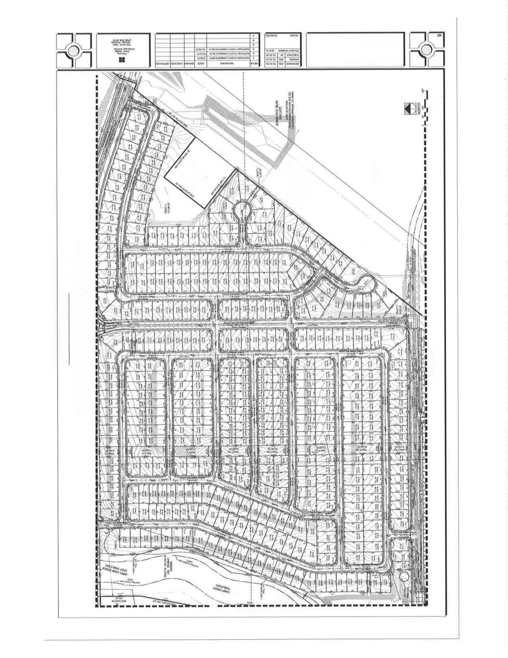
2 acres, are located north of the Peaceful Valley Lake Estates Subdivision, south of Bradley Road, west of the anticipated future extension of Meridian Road and east of Marksheffel Road, and more specifically located along the east side of the East Tributary of Jimmy Camp Creek, and are within Sections 13, 14, 23 and 24, Township 15 South, Range 65 West of the 6th P.M. The northernmost portion of the proposed PUD area is within the boundaries of the Highway 94 Comprehensive Plan (2003). The remaining southernmost portion is not included within a comprehensive planning area. The applicants are proposing to phase the development of 826 single-family lots, rightsof-way, a 25-acre school facility tract, a 17-acre future development tract, and 30 tracts for drainage, utilities, public improvements, easements, landscape, and open space, in five (5) phases as depicted on the plan. The Lorson Ranch East PUD development plan can meet the submittal and review criteria for a map amendment (rezoning) to a PUD (Planned Unit Development) zoning district if the requested PUD modifications are approved. The proposed PUD development plan also meets the submittal and review requirements for a preliminary plan as well as the general development standards of Chapter 6, the preliminary plan review criteria of Chapter 7, and the subdivision design requirements of Chapter 8 of the El Paso County Land Development Code (2016). The Board of County Commissioners has authorized the approval of a PUD development plan that also meets the requirements and standards of a preliminary plan to constitute approval of the preliminary plan. Water and wastewater services will be provided by Widefield Water and Sanitation Metropolitan District. A finding of water sufficiency is requested with the preliminary plan portion of this application. A. REQUEST/WAIVERS/MODIFICATIONS/AUTHORIZATION Request: Approval of a PUD development plan to develop 826 single-family residential lots, public rights-of-way, a school facility tract, a future development tract, and 30 tracts for drainage, easement, utility, public improvements, landscape, and open space. A finding of water sufficiency is also requested with the preliminary plan portion of this application. In accordance with Section E, of the El Paso County Land Development Code (2016), a PUD development plan may be approved as a preliminary plan. The applicants request that the PUD development plan also be approved as a preliminary plan. Pre-development site grading approval is also requested with the preliminary plan.

3 Modification of Existing Land Development Code (LDC) or Engineering Criteria Manual (ECM) Standard: For approval of a modification of a general development standard in the LDC or standard of the ECM, the BoCC shall find that the proposal provides for the general health, safety, and welfare of the citizens and at least one of the following benefits: Preservation of natural features; Provision of a more livable environment, such as the installment of street furniture, decorative street lighting or decorative paving materials; Provision of a more efficient pedestrian system; Provision of additional open space; Provision of other public amenities not otherwise required by the Code; or The proposed modification is granted in exchange for the open space and/or amenity designs provided in the PUD development plan and/or development guide. Modification of Section B.1 of the LDC The applicants are requesting approval of a PUD modification of Section B.1 of the LDC (2016) with this application. This section of the LDC requires roadway landscaping and landscape setbacks adjacent to roadways based upon the roadway classification. Section B.1, Table 6-1, Roadway Landscaping Required by Roadway Classification The applicants are proposing to reduce the number of trees to be planted adjacent to Fontaine Boulevard, a principal arterial, from a requirement of one (1) tree to be planted for every 20 feet of linear roadway to one tree per every 30 feet of linear roadway. The applicants are constructing Fontaine Boulevard to a collector (non-arterial) standard in the interim based on the average daily trips (ADT) that the development is anticipated to create. Fontaine Boulevard is anticipated to be brought up to a principal arterial road standard when the ADT warrant the upgrade. This long-term upgrade is anticipated in the El Paso County Major Transportation Corridors Plan Update (MTCP) (2016) and would be completed by other developers or the County, depending on long-term
 within a residential PUD.")
4 development in the area east of Lorson Ranch and the construction of the extension of Meridian Road along the eastern boundary of Lorson Ranch. Section B.2.e, Single-family PUD Roadway Landscaping, of the Code states, Roadway landscaping is not required along local residential roadways (non-arterial) within a residential PUD. Fontaine Boulevard, which will be constructed as a collector roadway, is not anticipated to be upgraded to a principle arterial until the average daily trip generation increases to warrant such arterial classification. It is anticipated the warrant would not be met for an undetermined number of years in the future; therefore, the PCD Director has recommended the PUD modification for the roadway landscape standards be approved. Modification of Section of the ECM The applicants are requesting approval of a PUD modification of Section of the ECM. This section of the ECM summarizes many of the minimum roadway design standards by category and functional classification, including intersection spacing and paved width. ECM Section , Table 2-7, Roadway Design Standards for Urban Collectors and Locals
5 The applicants are proposing to reduce the intersection spacing from 175 feet, as required, to 165 feet for urban local residential roadways intersecting with collector roadways. The specific intersections for which the PUD modification is being requested include the following: Lamprey Drive and Yamhill Drive Lamprey Drive and Shavers Drive Lamprey Drive and Clarion Drive Lamprey Drive and Aliso Drive Lamprey Drive and Nolin Drive Trappe Drive and Horton Drive The applicants are proposing to reduce the intersection spacing from 660 feet, as required, to 345 feet for urban residential collector roadways intersecting with collector roadways. The specific intersection for which the PUD modification is requested is the intersection of Trappe Drive and Magothy Drive. The applicants are proposing to reduce the intersection spacing from 660 feet, as required, to a minimum of 550 feet for urban residential collector roadways intersecting with collector roadways. The specific intersections for which the PUD modification is requested are the following: Lorson Boulevard and Willapa Drive (575 foot) Lorson Boulevard and Skuna Drive (550 foot) Lamprey Drive and Clarion Drive (561 foot) In the letter of intent, the applicants cite the need for the reductions in intersection spacing due to the limited development allowed within the Colorado Springs Utilities Southern Delivery System (SDS) easement and the powerline easement (both easements are depicted on the attached PUD Development Plan). Planning and Community Development Staff and the County Engineer/ECM Administrator have worked with the applicant to reduce the number of proposed PUD modifications and have no objection to the remaining reduced intersection spacing modifications, taking into account the Colorado Springs Utilities Southern Delivery System easement and the smaller size of the proposed urban lots. In addition, the traffic study supports the modifications and identifies that in the event of future improvements to Fontaine Boulevard, the accesses are anticipated to be modified to right-in/right-out or removed. Authorization to Sign: PUD Development Plan and any other documents required to finalize the approval.
6 B. APPROVAL CRITERIA The Planning Commission and BOCC shall determine that the following criteria as identified in Section of the El Paso County Land Development Code (2016) have been met in order to approve a PUD zoning district: The proposed PUD district zoning advances the stated purposes set forth in this section. The application is in general conformity with the Master Plan; The proposed development is in compliance with the requirements of this Code and all applicable statutory provisions and will not otherwise be detrimental to the health, safety, or welfare of the present or future inhabitants of El Paso County; The subject property is suitable for the intended uses and the use is compatible with both the existing and allowed land uses on the neighboring properties, will be in harmony and responsive with the character of the surrounding area and natural environment, and will not have a negative impact upon the existing and future development of the surrounding area; The proposed development provides adequate consideration for any potentially detrimental use to use relationships (e.g. commercial use adjacent to single family use) and provides an appropriate transition or buffering between uses of differing intensities both on-site and off-site which may include innovative treatments of use to use relationships; The allowed uses, bulk requirements and landscaping and buffering are appropriate to and compatible with the type of development, the surrounding neighborhood or area and the community; Areas with unique or significant historical, cultural, recreational, aesthetic or natural features are preserved and incorporated into the design of the project; Open spaces and trails are integrated into the development plan to serve as amenities to residents and provide reasonable walking and biking opportunities; The proposed development will not overburden the capacities of existing or planned roads, utilities and other public facilities (e.g. fire protection, police protection, emergency services, and water and sanitation), and the required public services and facilities will be provided to support the development when needed; The proposed development would be a benefit through the provision of interconnected open space, conservation of environmental features, aesthetic features and harmonious design, and energy efficient site design; The proposed land use does not permit the use of any area containing a commercial mineral deposit in a manner which would unreasonably interfere with the present or future extraction of such deposit unless acknowledged by the mineral rights owner; Any proposed exception or deviation from the requirements if the zoning resolution or the subdivision regulation is warranted by virtue of the design and amenities incorporated in the development plan and development guide; and
7 The owner has authorized the application. The applicants have requested the proposed PUD also be reviewed and considered as a preliminary plan. Compliance with the requirements identified in Chapter 7 and Chapter 8 of the El Paso County Land Development Code (2016) for a preliminary plan require the Planning Commission and the BoCC find that the following criteria for a preliminary plan have also been met.: The proposed subdivision is in general conformance with the goals, objectives, and policies of the Master Plan; The subdivision is consistent with the purposes of this Code; The subdivision is in conformance with the subdivision design standards and any approved sketch plan; A sufficient water supply has been acquired in terms of quantity, quality, and dependability for the type of subdivision proposed, as determined in accordance with the standards set forth in the water supply standards [C.R.S (6)(a)] and the requirements of Chapter 8 of this Code; A public sewage disposal system has been established and, if other methods of sewage disposal are proposed, the system complies with state and local laws and regulations, [C.R.S (6) (b)] and the requirements of Chapter 8 of this Code. All areas of the proposed subdivision, which may involve soil or topographical conditions presenting hazards or requiring special precautions, have been identified and the proposed subdivision is compatible with such conditions. [C.R.S (6)(c)]; Adequate drainage improvements complying with State law [C.R.S (3)(c)(VIII)] and the requirements of this Code and the ECM are provided by the design; Legal and physical access is or will be provided to all parcels by public rightsof-way or recorded easement, acceptable to the County in compliance with this Code and the ECM; The proposed subdivision has established an adequate level of compatibility by (1) incorporating natural physical features into the design and providing sufficient open spaces considering the type and intensity of the subdivision; (2) incorporating site planning techniques to foster the implementation of the County s plans, and encourage a land use pattern to support a balanced transportation system, including auto, bike and pedestrian traffic, public or mass transit if appropriate, and the cost effective delivery of other services consistent with adopted plans, policies and regulations of the County; (3) incorporating physical design features in the subdivision to provide a transition between the subdivision and adjacent land uses; (4) incorporating identified environmentally sensitive areas, including but not limited to, wetlands and wildlife corridors, into the design; and (5) incorporating public facilities or infrastructure, or provisions therefore, reasonably related to the
8 proposed subdivision so the proposed subdivision will not negatively impact the levels of service of County services and facilities; Necessary services, including police and fire protection, recreation, utilities, open space and transportation systems, are or will be available to serve the proposed subdivision; The subdivision provides evidence to show that the proposed methods for fire protection comply with Chapter 6 of this Code; and The proposed subdivision meets other applicable sections of Chapter 6 and 8 of this Code. D. LOCATION North: City of Colorado Springs South: RR-5 (Residential Rural) East: PUD (Planned Unit Development) West: PUD (Planned Unit Development) Vacant Single-family residential Vacant Single-family residential E. BACKGROUND The Lorson Ranch at Jimmy Camp Creek Sketch Plan (SKP ) was approved by the Board of County Commissioners on March 25, The Lorson Ranch Overall Development and Phasing Plan (PUD ) was approved by the Board of County Commissioners on December 15, The Overall Development and Phasing Plan was subsequently amended in November, 2006 (PUD ). The Overall Development and Phasing Plan approval addressed general land uses, overall density, and appropriate transitions and buffers. It also designated major open space, drainage, and transportation corridors. Approximately 1,737 single-family lots have been platted throughout the Lorson Ranch development. As development has occurred within the Lorson Ranch community, the anticipated open space and school locations have changed. Other changes include downgrading some of the roadway classifications within the development. A minor amendment to the Lorson Ranch at Jimmy Camp Creek Sketch Plan (SKP-15-1) was approved on April 21, The amendment included a revision to the location of the anticipated school site and open space as well as minor density changes within the planning area and downgrading the classification of certain roadways to be determined following review of traffic studies submitted with subsequent final plats. This request for approval of a acre development is proposed to include: 826 single-family residential lots; 30 drainage, open space, utility and easement tracts; a future development tract; and an El Paso County owned school site tract. The proposed overall density of 3.55 dwelling units per acre is consistent with the
9 approved amended sketch plan. The 25 acre school facility tract and the 17 acre future development tract are not included in the density calculation. The school facility tract depicted on the PUD development plan/preliminary plan is served by two roadways, Fontaine Boulevard and Lamprey Drive, and by utility infrastructure that the developer is required to construct pursuant to a School Site Dedication and Waiver of Fees in Lieu of Land Dedication agreement between Lorson, LLC, Widefield School District No. 3, and El Paso County, as originally approved by the Board of County Commissioners on April 12, 2012 and as amendment by approval of the Board of County Commissioners on August 23, The District is anticipated to submit a site development plan to the Planning and Community Development Department for the school facility; however, an exact date for that submittal is unknown at this time. F. ANALYSIS 1. Land Development Code Analysis The Lorson Ranch East PUD development plan and development guidelines comply with Section of the El Paso County Land Development Code (2016), except as otherwise altered by the requested PUD modifications. This application meets the Planned Unit Development submittal requirements and the standards for Planned Unit Development in Chapter 4 of the Code. This application also meets the preliminary plan submittal requirements, the General Development Standards of Chapter 6, the standards for Divisions of Land in Chapter 7, and the standards for Subdivision in Chapter 8 of the Code. 2. Zoning Compliance The Lorson Ranch East PUD development plan identifies allowed and accessory uses; use, density, and dimensional standards such as setbacks, maximum lot coverage, and maximum building height; and overall landscaping requirements. The Lorson Ranch East PUD Development Plan is consistent with the proposed PUD development guidelines and with the submittal and processing requirements of the Code. 3. Policy Plan Analysis A finding of consistency with the El Paso County Policy Plan (1998) was made with the previously approved Lorson Ranch Sketch Plan Amendment. The Lorson Ranch East PUD Development Plan/ Preliminary Plan is consistent with the approved sketch plan amendment.
10 4. Small Area Plan Analysis The northern portion of the proposed Lorson Ranch East PUD Development Plan/Preliminary Plan is within the Highway 94 Comprehensive Plan (2003) area. Specifically, the northern portion of the proposed PUD/preliminary plan is within Sub- Area 4, Colorado Centre, of the Highway 94 Plan. Fontaine Boulevard is depicted as the southern boundary line of the Plan area. The remainder of the proposed PUD/preliminary plan is not within the boundaries of a comprehensive planning area. The Colorado Centre Sub-Area identifies recommendations relative to development. The recommendations identified within the Plan are as follows: An overriding concern in the Sub-Area is compatibility with City industrial and residential areas. Urban uses are recommended for County enclaves surrounded by the City of Colorado Springs. Enclaves should be built to City standards and ultimately annexed in the City of Colorado Springs. Within unincorporated areas of the Sub-Area, five-acre densities are recommended. 35-acre densities are recommended east of Jimmy Camp Creek. Once City properties are developed, five-acre densities should be accommodated east of Jimmy Camp Creek. Approval of the original Lorson Sketch Plan (2003) and overall PUD development plan (2005) created an inconsistency with the third recommendation for the Sub- Area regarding densities east of Jimmy Camp Creek. Near the time of the sketch plan and overall PUD plan approval central services for water and wastewater were made available by the expansion of, Widefield Water and Sanitation District s service area into the Sub-Area promoting urban development to occur within the County in lieu of annexation into the City of Colorado Springs. The availability of central services inherently impacted the character of the Sub-Area from potential rural developments to more urban developments at higher densities without requiring annexation into the City of Colorado Springs. 5. Other Master Plan Elements The proposed PUD development plan/preliminary plan is consistent with or does not create negative impacts to elements depicted on the El Paso County Wildlife Habitat Descriptors Map (1996), the El Paso County Community Services Parks Master Plan (2014), the Master Plan for Mineral Extraction (1996), and the El Paso County Major Transportation Corridors Plan Update (2016), which is further addressed below.
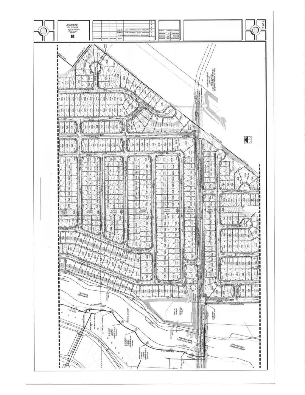
11 G. PHYSICAL SITE CHARACTERISTICS 1. Hazards A geology, soils, and hazards report was submitted with this request. The applicants propose to mitigate the hazards identified in the report by utilizing common construction practices to be determined with the issuance of lot specific building permits. There is floodplain depicted within the PUD development/preliminary plan. The lots that are proposed to be located within the floodplain shall not be platted until the Letter of Map Revision (LOMR) is completed. The earthwork and channel improvements necessary to complete the LOMR may not be completed until the preliminary plan is approved and issuance of pre-site development grading is approved by the Board of County Commissioners as requested. 2. Wildlife Potential impacts to wildlife are generally low to moderate as depicted in the El Paso County Wildlife Descriptors Map (1996). 3. Floodplain As indicated on FEMA Flood Insurance Rate Map (FIRM) panel numbers 08041C0957F and 08041C1000F, of the western edge of this development (proposed Tracts D and M) will be within the FEMA 100-year floodplain containing the Jimmy Camp Creek East Tributary. The Lorson Ranch developer has processed Conditional Letters of Map Revision (CLOMRs) through FEMA for each segment of the channel requiring improvements. Improvements to the portion of the East Tributary channel south of Fontaine Boulevard, continuing south of Lorson Boulevard have been completed with previous Lorson Ranch plats to the west, and a Letter of Map Revision (LOMR) accepting and mapping those improvements has been obtained from FEMA. Improvements to the East Tributary north of Fontaine Boulevard and the bridges over Lorson Boulevard and Fontaine Boulevard are all required in order to provide a stable drainage way and access to the Lorson Ranch East development. Each of these improvements will require floodplain development permits from the Regional Floodplain Administrator. The Lorson Ranch Metropolitan District No. 1 will be responsible for ownership and maintenance of the East Tributary through the site. 4. Drainage and Erosion The Lorson Ranch East development is located within the Jimmy Camp Creek drainage basin, which does not have a County-approved Drainage Basin Planning Study (DBPS). The Jimmy Camp Creek Basin has been studied and a DBPS adopted by the City of Colorado Springs in That study was not complete for County purposes; however, its design concepts are appropriate and acceptable and
12 are being used by the engineers for the purposes of designing the drainage plan for this development. Drainage and bridge fees are in effect under the Miscellaneous Drainage Basins (unstudied) category for the Jimmy Camp Creek basin and will apply at the time of platting. A Master Development Drainage Plan (MDDP) and Preliminary Drainage Report (PDR) were reviewed with the application for this PUD/preliminary plan. Developed stormwater runoff will be routed through on-site full-spectrum detention/water quality ponds which will limit runoff to approximately historic peak flow levels prior to discharging to Jimmy Camp Creek East Tributary. The reports conclude that with the proposed improvements, The proposed development and drainage infrastructure will not cause adverse impacts to adjacent properties or properties located downstream. Proposed improvements to the Jimmy Camp Creek East Tributary include low-flow channel grading, drop structures and bank stabilization measures north of Fontaine Boulevard. Improvements south of Fontaine Boulevard through the site have been constructed with previous Lorson Ranch subdivisions to the west as mentioned in the Floodplain section above. The applicants have requested pre-development site grading approval with the Lorson Ranch East PUD/Preliminary Plan. Grading and Erosion Control plans and a Stormwater Management Plan (SWMP) have been provided addressing measures to be taken to minimize erosion onsite and control sediment transfer onsite and downstream. 5. Transportation Lorson Ranch East is located east of Marksheffel Road past the current easternmost termination of Fontaine Boulevard. The development will take access from Fontaine Boulevard and Lorson Boulevard, both requiring bridges to be constructed over Jimmy Camp Creek East Tributary. Fontaine Boulevard is classified as a 4-lane principal arterial in the MTCP, connecting to Marksheffel Road on the west side of the overall Lorson Ranch development and eventually connecting to the future extension of Meridian Road along the east edge of the development. Fontaine Boulevard is currently constructed to Old Glory Drive, west of the East Tributary of Jimmy Camp Creek. The initial construction of Fontaine Boulevard through Lorson Ranch East will be a collector/minor arterial cross-section with a center left-turn lane to accommodate the
13 traffic generated by the proposed development as shown on the PUD/preliminary plan and the associated traffic impact study. Lorson Boulevard is proposed as a collector road providing a second point of access to Lorson Ranch East and will run from Marksheffel Road east, curving north and eventually connecting to Fontaine Boulevard east of the proposed Lorson Ranch East development. The first portion of Lorson Boulevard, which extends from Marksheffel Road to Jimmy Camp Creek, is being constructed with the Carriage Meadows South final plat. These existing and proposed roads are adequate to serve the Lorson Ranch East development. In the long-term, if it is necessary to widen Fontaine Boulevard or Lorson Boulevard to a 4-lane arterial cross-section, this development has provisions to allow deeding of necessary portions of the landscape tracts along these roads from the Lorson Ranch Metropolitan District No. 1 to the County at no cost to the County. This requirement is also addressed in the recommended conditions of approval. As described in Section A of this staff report, the applicants have requested several modifications to ECM standards with this PUD/preliminary plan. Section A also includes the recommendations of the LDC and EDM Administrators on each of modification requests. H. SERVICES 1. Water The site is proposed to be served by the Widefield Water and Sanitation District. Sufficiency: Sufficient Quality: Sufficient Quantity: Sufficient Dependability: Sufficient Attorney s summary: The County Attorney s Office makes a favorable recommendation for a finding of sufficiency with regard to water quantity and dependability for the preliminary plan portion of this request. El Paso County Public Health has made a favorable recommendation regarding water quality. The Board of County Commissioners is anticipated to make a finding for water sufficiency, including quality, quantity, and dependability, with approval of the preliminary plan portion of this request.
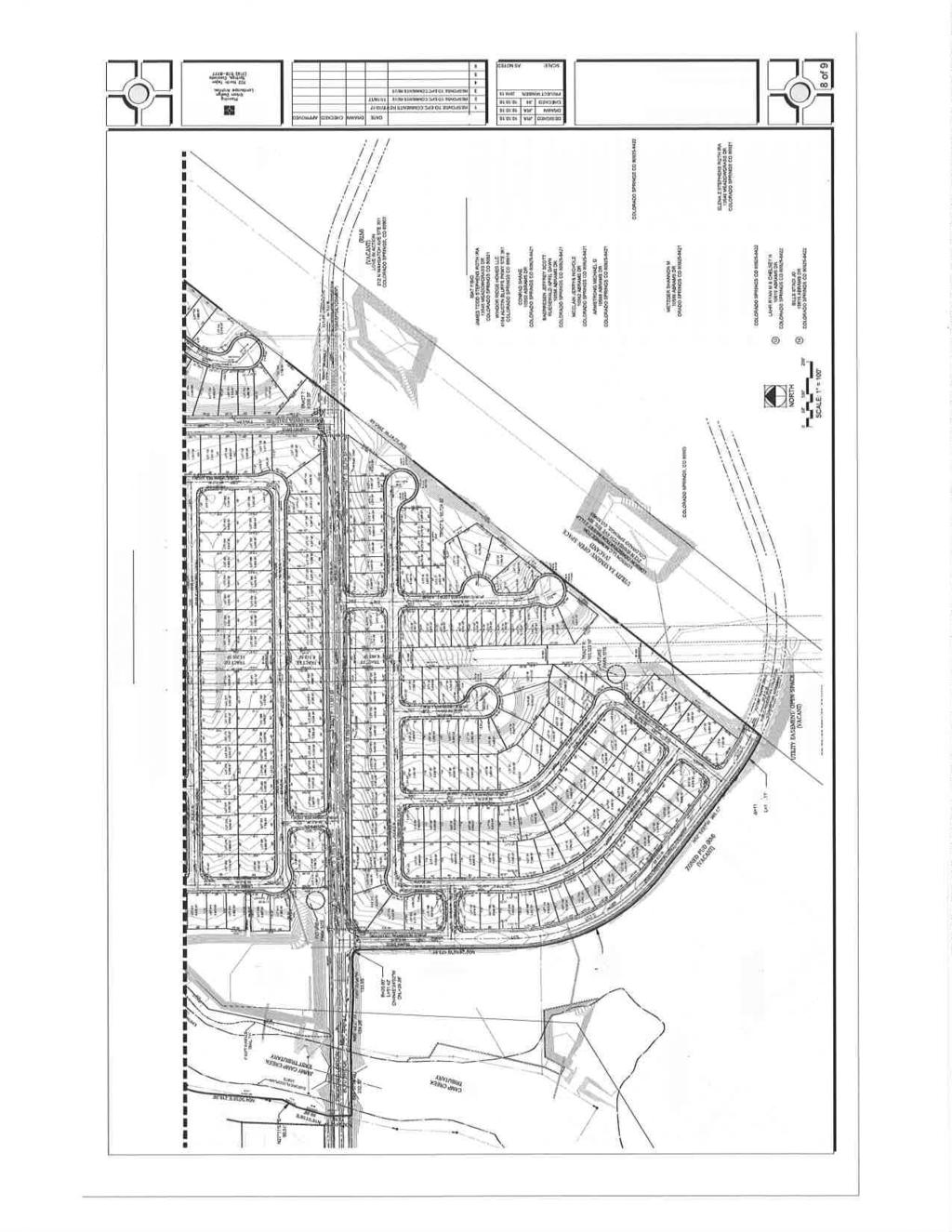
14 2. Sanitation The development is proposed to be served by the Widefield Water and Sanitation District. El Paso County Public Health has reviewed the wastewater report submitted with this application and has no concerns. 3. Emergency Services Security Fire Protection District has committed to serve the development. 4. Utilities Mountain View Electric Association will provide electrical service to the development. Black Hills Energy will provide natural gas to the development. Public utility easements, as applicable, shall be depicted on all final plats. 5. Metropolitan Districts The property is within Lorson Ranch Metropolitan District Nos. 1, 3, 4, and 5. It is anticipated by staff and the applicants that District No. 1 will be responsible for maintaining the open space, and landscaped areas along the platted public right-ofway throughout the development. 6. Parks/Trails Regional park (Area 4) fees and Urban park (Area 4) fees in lieu of land dedication shall be paid at the time of recordation of all final plats. The applicants are proposing to provide pedestrian connections to the trail corridor along the east tributary of Jimmy Camp Creek. The east tributary of Jimmy Camp Creek trail corridor ties into the trail at the northern boundary of the Lorson Ranch development heading west to the main branch of Jimmy Camp Creek where a regional trail corridor is located. 7. Schools This combined PUD development plan/preliminary plan is located within the boundaries of Widefield School District No. 3. The developer is not required to pay fees in lieu of land dedication for a school site pursuant to a School Site Dedication and Waiver of Fees in Lieu of Land Dedication agreement between Lorson, LLC, Widefield School District No. 3, and El Paso County, as originally approved by the Board of County Commissioners on April 12, 2012 and as amendment by approval of the Board of County Commissioners on August 23, The amendment removed the land bank located in the southeast corner of the overall Lorson Development, and instead requires an alternate 25 acre school site tract be identified, which occurred with the platting of the Pioneer Landing Filing No. 2
15 subdivision. The school site is depicted on sheet 4 of 9 of the PUD development plan/preliminary plan drawing attached below. I. APPLICABLE RESOLUTIONS Approval Page 29 and 25 Disapproval Page 30 and 26 J. STATUS OF MAJOR ISSUES There are no major issues or concerns with this application. K. CONDITIONS AND NOTATIONS Should the Planning Commission and the Board of County Commissioners find that the request meets the criteria for approval outlined in Section 4.2.6, and Section of the El Paso County Land Development Code (2016), staff recommends the following conditions and notations: CONDITIONS 1. Development of the property shall be in accordance with the combined PUD development plan/preliminary plan. Minor changes to the Plan, including a reduction in residential density, may be approved administratively by the Director of the Planning and Community Development Department consistent with the Land Development Code. Any substantial change will require submittal of a formal combined PUD development plan/preliminary plan amendment application. 2. Approved land uses are those defined in the PUD development plan and development guide. 3. All owners of record must sign the PUD development plan prior to recordation. 4. The PUD development plan shall be recorded in the office of the El Paso County Clerk & Recorder prior to scheduling any final plats for hearing by the Planning Commission. The development guide shall be recorded in conjunction with the PUD development plan. 5. Developer shall comply with federal and state laws, regulations, ordinances, review and permit requirements, and other agency requirements, if any, of applicable agencies including, but not limited to, the Colorado Parks and Wildlife, Colorado Department of Transportation, U.S. Army Corps of Engineers and the U.S. Fish and Wildlife Service regarding the Endangered Species Act, particularly as it relates to the Preble's Meadow Jumping Mouse as a listed threatened species.
16 6. Applicable park, school, drainage, bridge, and traffic fee shall be paid to El Paso County Planning and Community Development at the time of final plat(s) recordation. 7. Applicants and Lorson Ranch Metropolitan District agree that, with the respective final plat(s), all tracts adjacent to Lorson Boulevard and Fontaine Boulevard shall be reserved for potential public improvements to those roads. The Lorson Ranch Metropolitan District No. 1 will own and maintain these tracts until such time, if any, that the County requests the deeds conveying the portions of these tracts necessary for right-of-way purposes to El Paso County at no cost to the County. El Paso County, its agent(s) or assignee(s) may request the deeds and construct roadway improvements within these tracts at any time at the County s sole discretion. Landscaping allowed to remain within the acquired right-of-way shall continue to be maintained by Lorson Ranch Metropolitan District No. 1 under a Landscape License Agreement allowing maintenance of landscaping within the platted rights-of-way within Lorson Ranch East Filing No The Lorson Ranch Metropolitan District No. 1 shall accept and retain responsibility for maintaining detention/water quality facilities in Lorson Ranch East and the Jimmy Camp Creek East Tributary through the development. In accordance with Section 8.5.5(B) of the Land Development Code, the developer shall plat all tracts in their entirety that are deemed by the County to be necessary for drainage improvements and maintenance, including the Jimmy Camp Creek East Tributary, associated with each respective final plat within the Lorson Ranch East development. 9. In accordance with the Lorson Ranch Sixth Amended Development Agreement, no more than 1,750 dwelling units shall be permitted east of Jimmy Camp Creek until both bridges over Jimmy Camp Creek have been constructed to provide a second point of access. 10. No lots within the limits of the floodplain shall be final platted until the LOMR is approved for the affected areas. NOTATIONS 1. If a zone or rezone petition has been disapproved by the Board of County Commissioners, resubmittal of the previously denied petition will not be accepted for a period of one (1) year if it pertains to the same parcel of land and is a petition for a change to the same zone that was previously denied. However, if evidence is presented showing that there has been a substantial change in physical conditions
17 or circumstances, the Planning Commission may reconsider said petition. The time limitation of one (1) year shall be computed from the date of final determination by the Board of County Commissioners or, in the event of court litigation, from the date of the entry of final judgment of any court of record. 2. Rezoning requests not forwarded to the Board of County Commissioners for consideration within 180 days of Planning Commission action will be deemed withdrawn and will have to be resubmitted in their entirety. 3. Preliminary plans not forwarded to the Board of County Commissioners within 12 months of Planning Commission action shall be deemed withdrawn and shall have to be resubmitted in their entirety. 4. Approval of the preliminary plan portion of the combined plan will expire after two (2) years unless a final plat has been approved and recorded or a time extension has been granted. L. PUBLIC COMMENT AND NOTICE The Planning and Community Development Department notified forty seven (47) adjoining property owners on December 14, 2017, for the Planning Commission meeting. Responses will be provided at the hearing. M. ATTACHMENTS Vicinity Map Letter of Intent Development Plan / Preliminary Plan Amended Sketch Plan (2016) State Engineers Letter County Attorney s Letter Widefield Water and Sanitation District El Paso County Public Health
18
19
20
21
22
23
24
25
26
27
28
29
30
31
32
33

34
35

36
37

38
39
40
41
42
43

44
45
46
47
48
49
50
51
Project File #: SF Project Name: Jackson Ranch Filing No. 4 Parcel Nos.: , and
 COMMISSIONERS: DARRYL GLENN (PRESIDENT) MARK WALLER (PRESIDENT PRO TEMPORE) STAN VANDERWERF LONGINOS GONZALEZ PEGGY LITTLETON PLANNING AND COMMUNITY DEVELOPMENT DEPARTMENT CRAIG DOSSEY, EXECUTIVE DIRECTOR
Planning Commission Hearing Date: 3/6/2018 Board of County Commissioners Hearing Date 3/27/2018
 COMMISSIONERS: DARRYL GLENN (PRESIDENT) MARK WALLER (PRESIDENT PRO TEMPORE) STAN VANDERWERF LONGINOS GONZALEZ PEGGY LITTLETON PLANNING AND COMMUNITY DEVELOPMENT DEPARTMENT CRAIG DOSSEY, EXECUTIVE DIRECTOR
Planning Commission Hearing Date: 2/21/2017 Board of County Commissioners Hearing Date: 3/8/2017
 COMMISSIONERS: DARRYL GLENN (PRESIDENT) MARK WALLER (PRESIDENT PRO TEMPORE) STAN VANDERWERF LONGINOS GONZALEZ PEGGY LITTLETON PLANNING AND COMMUNITY DEVELOPMENT DEPARTMENT CRAIG DOSSEY, EXECUTIVE DIRECTOR
Planning Commission Hearing Date: 5/2/2017 Board of County Commissioners Hearing Date 5/23/2017
 COMMISSIONERS: DARRYL GLENN (PRESIDENT) MARK WALLER (PRESIDENT PRO TEMPORE) STAN VANDERWERF LONGINOS GONZALEZ PEGGY LITTLETON PLANNING AND COMMUNITY DEVELOPMENT DEPARTMENT CRAIG DOSSEY, EXECUTIVE DIRECTOR
Project File #: SF Project Name: Meadowbrook Crossing Filing No. 1 Final Plat Parcel No.:
 COMMISSIONERS: DARRYL GLENN (PRESIDENT) MARK WALLER (PRESIDENT PRO TEMPORE) STAN VANDERWERF LONGINOS GONZALEZ PEGGY LITTLETON PLANNING AND COMMUNITY DEVELOPMENT DEPARTMENT CRAIG DOSSEY, EXECUTIVE DIRECTOR
REPRESENTATIVE: NES, Inc. 619 North Cascade Avenue, Suite 200 Colorado Springs, CO 80903
 COMMISSIONERS: MARK WALLER (CHAIR) LONGINOS GONZALEZ, JR. (VICE-CHAIR) HOLLY WILLIAMS STAN VANDERWERF CAMI BREMER PLANNING AND COMMUNITY DEVELOPMENT DEPARTMENT CRAIG DOSSEY, EXECUTIVE DIRECTOR TO: FROM:
Project File #: VA Project Name: Beauperthuy Variance Parcel Nos.: , , , ,
 COMMISSIONERS: DARRYL GLENN (PRESIDENT) MARK WALLER (PRESIDENT PRO TEMPORE) STAN VANDERWERF LONGINOS GONZALEZ PEGGY LITTLETON PLANNING AND COMMUNITY DEVELOPMENT DEPARTMENT CRAIG DOSSEY, EXECUTIVE DIRECTOR
Project File #: SP Project Name: Springs at Waterview Preliminary Plan Parcel No.:
 COMMISSIONERS: DARRYL GLENN (PRESIDENT) MARK WALLER (PRESIDENT PRO TEMPORE) STAN VANDERWERF LONGINOS GONZALEZ PEGGY LITTLETON PLANNING AND COMMUNITY DEVELOPMENT DEPARTMENT CRAIG DOSSEY, EXECUTIVE DIRECTOR
REPRESENTATIVE: Centerline Solutions Table Mountain Parkway Golden, CO 80403
 COMMISSIONERS: DARRYL GLENN (PRESIDENT) MARK WALLER (PRESIDENT PRO TEMPORE) STAN VANDERWERF LONGINOS GONZALEZ PEGGY LITTLETON PLANNING AND COMMUNITY DEVELOPMENT DEPARTMENT CRAIG DOSSEY, EXECUTIVE DIRECTOR
Letter of Intent May 2017 (Revised November 2017)
") THE BEACH AT WOODMOOR LETTER OF INTENT MAY 2017 (REVISED NOVEMBER 2017) OWNER/APPLICANT: CONSULTANT: Lake Woodmoor Holdings LLC N.E.S. Inc. 1755 Telstar Drive, Suite 211 619 North Cascade Avenue Colorado
THE BEACH AT WOODMOOR LETTER OF INTENT MAY 2017 (REVISED NOVEMBER 2017) OWNER/APPLICANT: CONSULTANT: Lake Woodmoor Holdings LLC N.E.S. Inc. 1755 Telstar Drive, Suite 211 619 North Cascade Avenue Colorado
REPRESENTATIVE: Julie & Brad Nicodemus Black Squirrel Road Colorado Springs, CO 80809
 COMMISSIONERS: DARRYL GLENN (PRESIDENT) MARK WALLER (PRESIDENT PRO TEMPORE) STAN VANDERWERF LONGINOS GONZALEZ PEGGY LITTLETON PLANNING AND COMMUNITY DEVELOPMENT DEPARTMENT CRAIG DOSSEY, EXECUTIVE DIRECTOR
Project File #: P Project Name: Springs at Waterview Residential Rezone Parcel No.:
 COMMISSIONERS: DARRYL GLENN (PRESIDENT) MARK WALLER (PRESIDENT PRO TEMPORE) STAN VANDERWERF LONGINOS GONZALEZ PEGGY LITTLETON PLANNING AND COMMUNITY DEVELOPMENT DEPARTMENT CRAIG DOSSEY, EXECUTIVE DIRECTOR
Gabe Sevigney, Project Manager/Planner I Gilbert LaForce, Engineer II Craig Dossey, Executive Director Planning & Community Development
 COMMISSIONERS: DARRYL GLENN (PRESIDENT) MARK WALLER (PRESIDENT PRO TEMPORE) STAN VANDERWERF LONGINOS GONZALEZ PEGGY LITTLETON PLANNING AND COMMUNITY DEVELOPMENT DEPARTMENT CRAIG DOSSEY, EXECUTIVE DIRECTOR
Nina Ruiz, Project Manager/Planner II Gilbert LaForce, Engineer II Craig Dossey, Executive Director Planning & Community Development
 COMMISSIONERS: DARRYL GLENN (PRESIDENT) MARK WALLER (PRESIDENT PRO TEMPORE) STAN VANDERWERF LONGINOS GONZALEZ PEGGY LITTLETON PLANNING AND COMMUNITY DEVELOPMENT DEPARTMENT CRAIG DOSSEY, EXECUTIVE DIRECTOR
Nina Ruiz, PM/Planner II Mike Hrebenar, Project Management Group Manager Elizabeth Nijkamp, PE Engineering Manager Craig Dossey, Executive Director
 COMMISSIONERS: DARRYL GLENN (PRESIDENT) MARK WALLER (PRESIDENT PRO TEMPORE) STAN VANDERWERF LONGINOS GONZALEZ PEGGY LITTLETON PLANNING AND COMMUNITY DEVELOPMENT DEPARTMENT CRAIG DOSSEY, EXECUTIVE DIRECTOR
MS MINOR SUBDIVISION TREVITHICK
 MS-02-015 341.12 MINOR SUBDIVISION TREVITHICK A request by Danny Trevithick for a one-lot Minor Subdivision on five acres. The property is zoned A-35 (Agricultural) District and is located ¼ mile south
REPRESENTATIVE: Kesti Suggs Holmes Rd Colorado Springs, CO 80908
 COMMISSIONERS: DARRYL GLENN (PRESIDENT) MARK WALLER (PRESIDENT PRO TEMPORE) STAN VANDERWERF LONGINOS GONZALEZ PEGGY LITTLETON PLANNING AND COMMUNITY DEVELOPMENT DEPARTMENT CRAIG DOSSEY, EXECUTIVE DIRECTOR
Staff Report: Date: Applicant: Property Identification: Acreage of Request: Current Zoning of Requested Area: Requested Action: Attached:
 Staff Report: Completed by Jeff Palmer Director of Planning & Zoning Date: November 7, 2018, Updated November 20, 2018 Applicant: Greg Smith, Oberer Land Developer agent for Ronald Montgomery ET AL Property
Guide to Minor Developments
 Guide to Minor Developments Introduction The Douglas County (DCD) is committed to providing open, transparent application processes to the public. This Guide is provided to assist anyone interested in
Staff Report: Date: Applicant: Property Identification: Acreage of Request: Current Zoning of Requested Area: Requested Action: Attached:
 Staff Report: Completed by Jeff Palmer Director of Planning & Zoning Date: November 7, 2018 Applicant: Greg Smith, Oberer Land Developer agent for Ronald Montgomery ET AL Property Identification: Frontage
Guide to Combined Preliminary and Final Plats
 Guide to Combined Preliminary and Final Plats Introduction The Douglas County is committed to providing open, transparent application processes to the public. This Guide is provided to assist anyone interested
Guide to Preliminary Plans
 Guide to Preliminary Plans Introduction The Douglas County is committed to providing open, transparent application processes to the public. This Guide is provided to assist anyone interested in the procedures
Project File #: SF Project Name: Redtail Ranch Subdivision Parcel Nos.: , , ,
 COMMISSIONERS: MARK WALLER (CHAIR) LONGINOS GONZALEZ, JR. (VICE-CHAIR) HOLLY WILLIAMS STAN VANDERWERF CAMI BREMER PLANNING AND COMMUNITY DEVELOPMENT DEPARTMENT CRAIG DOSSEY, EXECUTIVE DIRECTOR TO: FROM:
Public Notice U.S. ARMY CORPS OF ENGINEERS, GALVESTON DISTRICT AND TEXAS COMMISSION ON ENVIRONMENTAL QUALITY
 Public Notice U.S. Army Corps Permit Application No: SWG-2016-00384 Of Engineers Date Issued: 27 December 2018 Galveston District Comments Due: 29 January 2019 U.S. ARMY CORPS OF ENGINEERS, GALVESTON DISTRICT
Planning Department Oconee County, Georgia
 Planning Department Oconee County, Georgia STAFF REPORT REZONE CASE #: 6985 DATE: October 31, 2016 STAFF REPORT BY: Andrew C. Stern, Planner APPLICANT NAME: Williams & Associates, Land Planners PC PROPERTY
CITY PLANNING COMMISSION AGENDA ITEM NOS: B.1-B.3 STAFF: MEGGAN HERINGTON
 Page 17 CITY PLANNING COMMISSION AGENDA ITEM NOS: B.1-B.3 STAFF: MEGGAN HERINGTON FILE NO(S): CPC MP 87-00381-A13MN14 QUASI-JUDICIAL CPC PUZ 14-00101 QUASI-JUDICIAL CPC PUP 05-00139-A1MJ14 QUASI-JUDICIAL
ARTICLE 15 - PLANNED UNIT DEVELOPMENT
 Section 15.1 - Intent. ARTICLE 15 - PLANNED UNIT DEVELOPMENT A PUD, or Planned Unit Development, is not a District per se, but rather a set of standards that may be applied to a development type. The Planned
PLANNED UNIT DEVELOPMENTS (Ordinance No.: 3036, 12/3/07; Repealed & Replaced by Ordinance No.: 4166, 10/15/12)
") 159.62 PLANNED UNIT DEVELOPMENTS (Ordinance No.: 3036, 12/3/07; Repealed & Replaced by Ordinance No.: 4166, 10/15/12) A. PURPOSE 1. General. The Planned Unit Development (PUD) approach provides the flexibility
159.62 PLANNED UNIT DEVELOPMENTS (Ordinance No.: 3036, 12/3/07; Repealed & Replaced by Ordinance No.: 4166, 10/15/12) A. PURPOSE 1. General. The Planned Unit Development (PUD) approach provides the flexibility
SUBJECT PARCEL(S) Property Owner(s) TMS Number Approximate Acreage Carolina Park Development, LLC
 Property Owner(s) TMS Number Approximate Acreage Carolina Park Development, LLC") Staff Report Special Planning Commission Meeting November 19, 2014 For reference, the Zoning Code and Land Development Regulations are available online. AGENDA ITEM 5c. SKETCH PLAN APPROVAL REQUEST: Request
Staff Report Special Planning Commission Meeting November 19, 2014 For reference, the Zoning Code and Land Development Regulations are available online. AGENDA ITEM 5c. SKETCH PLAN APPROVAL REQUEST: Request
Project File #: VR Project Name: Claremont Ranch Filing 9C Vacate Replat Parcel No.:
 COMMISSIONERS: DARRYL GLENN (PRESIDENT) MARK WALLER (PRESIDENT PRO TEMPORE) STAN VANDERWERF LONGINOS GONZALEZ PEGGY LITTLETON PLANNING AND COMMUNITY DEVELOPMENT DEPARTMENT CRAIG DOSSEY, EXECUTIVE DIRECTOR
PLANNED UNIT DEVELOPMENT & SUBDIVISION STAFF REPORT Date: April 18, 2019
 PLANNED UNIT DEVELOPMENT & SUBDIVISION STAFF REPORT Date: April 18, 2019 DEVELOPMENT NAME SUBDIVISION NAME Springhill Village Subdivision Springhill Village Subdivision LOCATION 4350, 4354, 4356, 4358,
Cover Letter with Narrative Statement
 Cover Letter with Narrative Statement March 31, 2017 rev July 27, 2017 RE: Rushton Pointe Residential Planned Unit Development Application for Public Hearing for RPUD Rezone PL2015 000 0306 Mr. Eric Johnson,
Medical Marijuana Special Exception Use Information
 Medical Marijuana Special Exception Use Information The Special Exception Use information below is a modified version of the Unified Development Code. It clarifies the current section 5:104 Special Exceptions
Town of Norwich, Vermont SUBDIVISION REGULATIONS
 Town of Norwich, Vermont SUBDIVISION REGULATIONS Adopted: August 6, 2002 Amended: February 8, 2006 Prepared by Norwich Planning Commission with the assistance of: Burnt Rock Inc. A ssociates in Community
MIDWAY CITY Municipal Code
 MIDWAY CITY Municipal Code TITLE 9 ANNEXATION CHAPTER 9.01 PURPOSE CHAPTER 9.02 GENERAL REQUIREMENTS CHAPTER 9.03 PROPERTY OWNER INITIATION OF ANNEXATION CHAPTER 9.04 PROCEDURES FOR CONSIDERATION OF PETITION
Town of Cary, North Carolina Rezoning Staff Report 14-REZ-31 Cary Park PDD Amendment (Waterford II) Town Council Meeting January 15, 2015
 Town Council Meeting January 15, 2015") Town of Cary, North Carolina Rezoning Staff Report 14-REZ-31 Cary Park PDD Amendment (Waterford II) Town Council Meeting January 15, 2015 REQUEST To amend the Town of Cary Official Zoning Map by amending
Town of Cary, North Carolina Rezoning Staff Report 14-REZ-31 Cary Park PDD Amendment (Waterford II) Town Council Meeting January 15, 2015 REQUEST To amend the Town of Cary Official Zoning Map by amending
Article 6: Planned Unit Developments
 LUDC 2013 GARFIELD COUNTY, COLORADO Article 6: Planned Unit Developments ARTICLE 6 PLANNED UNIT DEVELOPMENTS TABLE OF CONTENTS DIVISION 1. GENERAL.... 1 6-101. GENERAL PROVISIONS.... 1 A. Purpose....
Larimer County Planning Dept. Procedural Guide for 1041 PERMITS
 - Larimer County Planning Dept. Procedural Guide for 1041 PERMITS PLEASE NOTE: A PRE-APPLICATION CONFERENCE IS REQUIRED PRIOR TO SUBMITTING THIS APPLICATION. PURPOSE: State Statutes allow local governments
Section 4 Master Plan Framework
 Section 4 Master Plan Framework 4.1 PURPOSE The Master Plan, as an implementation tool of the SPC District, establishes the primary framework for the overall development of the Property. Detailed site
REPORT TO THE SHELBY COUNTY PLANNING COMMISSION From the Department of Development Services Planning Services. February 4, 2019
 REPORT TO THE SHELBY COUNTY PLANNING COMMISSION From the Department of Development Services Planning Services February 4, 2019 Case No. Request for Rezoning Approval From E-1 to E-2 SD This is a request
Chapter 5. Floodplain Management. 5.0 Introduction. 5.1 Douglas County Comprehensive Master Plan. 5.2 Floodplain Management and Regulation
 5.0 Introduction This chapter summarizes the County s rules and regulations regarding floodplain management and development. The requirements presented in this chapter should be used by the design engineer
SUBDIVISION REGULATIONS
 CHAPTER 14 SUBDIVISION REGULATIONS 14-100 Provisions 14-200 Preliminary Plat 14-300 Final Plat 14-400 Replat 14-500 Minor Subdivision 14-600 Administrative Replat 14-700 Vacation of Roadways, Public Easements,
SECTION 16. "PUD" PLANNED UNIT DEVELOPMENT OVERLAY DISTRICT
 SECTION 6. "PUD" PLANNED UNIT DEVELOPMENT OVERLAY DISTRICT Subsection. Purpose. This district is established to achieve the coordinated integration of land parcels and large commercial and retail establishments
CHAPTER 10 Planned Unit Development Zoning Districts
 CHAPTER 10 Planned Unit Development Zoning Districts Section 10.1 Intent and Purpose The Planned Unit Development (PUD) districts are intended to offer design flexibility for projects that further the
Chapter 100 Planned Unit Development in Corvallis Urban Fringe
 100.100 Scope and Purpose. Chapter 100 Planned Unit Development in Corvallis Urban Fringe (1) All applications for land divisions in the Urban Residential (UR) and Flood Plain Agriculture (FPA) zones within
STAFF REPORT FOR MAJOR SUBDIVISION
 STAFF REPORT FOR MAJOR SUBDIVISION FINAL PLAT CASE NO. FA-12-003 HEARING DATE: November 6, 2013 CASE NAME: Solterra Subdivision Filing No. 13 PROCEDURE: Planning Commission ADDRESS OF MAJOR SUBDIVISION
CASE NO.: PLT CASE NAME: BLACKSTONE RANCH, FILING 3
 Exhibit 1 - Staff Report COMMUNITY AND ECONOMIC DEVELOPMENT DEPARTMENT TABLE OF CONTENTS CASE NO.: PLT2017-00002 CASE NAME: BLACKSTONE RANCH, FILING 3 EXHIBIT 1 PC Staff Report EXHIBIT 2- Maps 2.1 Aerial
STAFF REPORT FOR MAJOR SUBDIVISION
 STAFF REPORT FOR MAJOR SUBDIVISION FINAL PLAT CASE NO. FA-13-001 HEARING DATE: November 6, 2013 CASE NAME: Solterra Subdivision Filing No. 14 PROCEDURE: Planning Commission ADDRESS OF MAJOR SUBDIVISION
In order to permit maximum applicability of the PUD District, PUD-1 and PUD-2 Districts are hereby created.
 ARTICLE III. PUD ned Unit Development Overlay District 205-128. Purpose. The PUD ned Unit Development Overlay District is intended to provide flexibility in the design of planned projects; to encourage
DOUGLAS COUNTY SUBDIVISION RESOLUTION Article 4 Preliminary Plan 10/13/2015
 ARTICLE 4 PRELIMINARY PLAN 401 Intent An in-depth analysis of the proposed subdivision, including a review of the design considering the ability to obtain water and sanitation, identified geologic hazards,
Chapter 5. Floodplain Management. 5.0 Introduction. 5.1 Floodplain Management and Regulation
 5.0 Introduction This chapter summarizes the Town s rules and regulations regarding floodplain management and development. The requirements presented in this chapter should be used by the design engineer
Article 2 Application Type and Standards Requirements
 Article 1 Article 2 Division 1 Application Type and Standards Requirements General Provisions Sec. 2.1.1 Division 2 Division 3 Division 4 Division 5 Division 6 Division 7 Division 8 Division 9 Sec. 2.9.1
1.94 acres. Gwinnett Prado, L.P. c/o Brogdon Consulting Duluth, GA Contact: Ted Sandler
 Land Use Petition RZ-15-006 Date of Staff Recommendation Preparation: April 21, 2015 Revised to Incorporate Planning Commission Recommendations: 5/6/15 PROJECT LOCATION: 10800 Block of State Bridge Road
MINOR BOUNDARY LINE ADJUSTMENT PROCESS GUIDE
 MINOR BOUNDARY LINE ADJUSTMENT PROCESS GUIDE Clear Creek County Planning Department P.O. Box 2000 Georgetown, Colorado 80444 (303) 679-2436 phone (303) 569-1103 fax 1 PURPOSE To establish criteria and
ARTICLE 14 PLANNED UNIT DEVELOPMENT (PUD) DISTRICT
 DISTRICT") ARTICLE 14 PLANNED UNIT DEVELOPMENT (PUD) DISTRICT Section 14.01 Intent. It is the intent of this Article to allow the use of the planned unit development (PUD) process, as authorized by the Michigan Zoning
ARTICLE 14 PLANNED UNIT DEVELOPMENT (PUD) DISTRICT Section 14.01 Intent. It is the intent of this Article to allow the use of the planned unit development (PUD) process, as authorized by the Michigan Zoning
Residential Project Convenience Facilities
 Standards for Specific Land Uses 35.42.220 E. Findings. The review authority shall approve a Land Use Permit in compliance with Subsection 35.82.110.E (Findings required for approval) or a Conditional
CHARLOTTE PLANNING COMMISSION FINDINGS OF FACT AND DECISION IN RE APPLICATION OF. George R. Aube 1450 Dorset Street
 CHARLOTTE PLANNING COMMISSION FINDINGS OF FACT AND DECISION IN RE APPLICATION OF George R. Aube 1450 Dorset Street Final Plan Review For A Two-Lot Subdivision Application # PC-13-19 Background The Planning
Marion County Board of County Commissioners
 Marion County Board of County Commissioners Date: 12/29/2015 P&Z: 12/28/2015 BCC: 1/12/2016 Item Number 160113Z Type of Application Rezoning Request From: A-1 (General Agriculture) To: PUD (Planned Unit
Guide to Replats. Step 1. Step 2. Step 3. Step 4. Step 5. Step 6. Step 7. Step 8. Step 9. Step 10
 Guide to Replats Introduction Douglas County is committed to providing open, transparent application processes to the public. This Guide is provided to assist anyone interested in the procedures and expectations
SECTION 7000 LAND DEVELOPMENT REQUIREMENTS
 SECTION 7000 LAND DEVELOPMENT REQUIREMENTS 7000 LAND DEVELOPMENT REQUIREMENTS... 1 7001 LEGISLATIVE AUTHORITY... 1 7001.1 LAND DEVELOPMENT... 1 7001.1.1 Title 40, Idaho Code... 1 7001.1.2 Idaho Code 40-1415
Cobb County Community Development Agency Zoning Division 1150 Powder Springs St. Marietta, Georgia 30064
 Cobb County Community Development Agency Zoning Division 1150 Powder Springs St. Marietta, Georgia 30064 Case # Z-63 Public Hearing Dates: PC: 11-06-18 BOC: 11-20-18 SITE BACKGROUND Applicant: Loyd Development
CITY PLANNING COMMISSION AGENDA ITEM NOS: 15,16,17,18,19 STAFF: PATRICIA PARISH
 Page 185 CITY PLANNING COMMISSION AGENDA ITEM NOS: 15,16,17,18,19 STAFF: PATRICIA PARISH FILE NOS: CPC A 05-00193 LEGISLATIVE CPC ZC 05-00194 LEGISLATIVE CPC ZC 05-00195 LEGISLATIVE CPC CP 05-00196 QUASI-JUDICIAL
Operating Standards Attachment to Development Application
 Planning & Development Services 2255 W Berry Ave. Littleton, CO 80120 Phone: 303-795-3748 Mon-Fri: 8am-5pm www.littletongov.org Operating Standards Attachment to Development Application 1 PLANNED DEVELOPMENT
ARTICLE XXI GENERAL SITE DEVELOPMENT PLAN REQUIREMENTS
 1 2 3 4 5 6 7 8 9 10 11 12 13 14 15 16 17 18 19 20 21 22 23 24 25 ARTICLE XXI GENERAL SITE DEVELOPMENT PLAN REQUIREMENTS Section 21.1 Purpose and Intent... 2 Section 21.2 Administrative Site Plan Review
SITE PLAN REVIEW PROCEDURES SECTION DEVELOPMENTS REQUIRING SITE PLAN APPROVAL
 SECTION 22.01 PURPOSE ARTICLE XXII PROCEDURES The purpose of this Article is to establish uniform requirements of procedure for all developments in the Township. Certain specific types of minor development
Chapter 210 CONDITIONAL USES
 Chapter 210 CONDITIONAL USES 210.01 Purpose 210.02 Authorization 210.03 Process Type 210.04 Determination of Major or Minor Conditional Use Review 210.05 Approval Criteria 210.06 Conditions of Approval
STAFF REPORT FOR MAJOR SUBDIVISION
 STAFF REPORT FOR MAJOR SUBDIVISION FINAL PLAT CASE NO. FA-14-001 HEARING DATE: January 6, 2016 CASE NAME: Solterra Subdivision Filing No. 16 PROCEDURE: Planning Commission ADDRESS OF MAJOR SUBDIVISION
Planning Department Oconee County, Georgia STAFF REPORT
 Planning Department Oconee County, Georgia STAFF REPORT REZONE CASE #: 7332 DATE: November 28, 2017 STAFF REPORT BY: Gabriel Quintas, Planner APPLICANT NAME: Smith Planning Group PROPERTY OWNER: John Hadden
when the following proceedings, among others were held and done, to-wit:
 STATE OF COLORADO ) COUNTY OF ADAMS ) At a regular meeting of the Board of County Commissioners for Adams County, Colorado, held at the Administration Building in Brighton, Colorado on the 2 nd day of
Plan nt Plan Filing and
 PARISH OF ASCENSION OFFICE OF PLANNING AND DEVELOPMENT PLANNING DEPARTMENT APPENDIX VI PLANNED UNIT DEVELOPMENT (PUD) CODE Contents: 17-601. General Purpose: Procedures... 3 17-602. General Character:...
WHEREAS, the staff of The Maryland-National Capital Park and Planning Commission recommended APPROVAL of the application with conditions; and
 R E S O L U T I O N WHEREAS, Redeemed Christian Church of God is the owner of a 2.83-acre parcel of land known as Lot 9, Lot 19, P/O Lot 1 and P/O Lot 18, Block B, Plat Book A, Plat 5, said property being
MAJOR BOUNDARY LINE ADJUSTMENT PROCESS GUIDE
 MAJOR BOUNDARY LINE ADJUSTMENT PROCESS GUIDE Clear Creek County Planning Department P.O. Box 2000 Georgetown, Colorado 80444 (303) 679-2436 - phone (303) 569-1103 - fax PURPOSE To establish criteria and
ZONING ORDINANCE: OPEN SPACE COMMUNITY. Hamburg Township, MI
 ZONING ORDINANCE: OPEN SPACE COMMUNITY Hamburg Township, MI ARTICLE 14.00 OPEN SPACE COMMUNITY (Adopted 1/16/92) Section 14.1. Intent It is the intent of this Article to offer an alternative to traditional
WESTMINSTER PARK SUBDIVISION
 WESTMINSTER PARK SUBDIVISION Engineering Comments: FINAL PLAT COMMENTS (should be addressed prior to submitting the FINAL PLAT for review and/or signature by the City Engineer): A. Provide all of the required
SPECIAL ZONING DISTRICTS
 SPECIAL ZONING DISTRICTS 5.01 5.99 RESERVED 5.100 PLANNED DEVELOPMENTS: Purpose: This district is intended to accommodate unified design of residential, commercial, office, professional services, retail
ARTICLE VII. NONCONFORMITIES. Section 700. Purpose.
 ARTICLE VII. NONCONFORMITIES. Section 700. Purpose. The purpose of this chapter is to regulate and limit the development and continued existence of legal uses, structures, lots, and signs established either
ZONING AMENDMENT, PLANNED UNIT DEVELOPMENT & SUBDIVISION STAFF REPORT Date: August 8, 2013
 ZONING AMENDMENT, PLANNED UNIT DEVELOPMENT & SUBDIVISION STAFF REPORT Date: August 8, 2013 NAME SUBDIVISION NAME PV-Magnolia, LLC Twelve Trees Subdivision LOCATION 2860, 2862 and 2866 Pleasant Valley Road
Plans shall be drawn at a readable scale, signed, and sealed by a Florida Registered Engineer. The application package shall include:
 CHAPTER 400. SECTION 403. PERMIT TYPES AND APPLICATIONS SITE DEVELOPMENT 403.3. Preliminary Site Plans (PSP) A. Intent and Purpose PSPs are used to identify existing site conditions and demonstrate general
AAAA. Planning and Zoning Staff Report Lake Shore Land Holdings, LLC CU-PH Analysis
 AAAA Planning and Zoning Staff Report Lake Shore Land Holdings, LLC CU-PH2016-28 Hearing Date: April 21, 2016 Development Services Department Applicant: BRS Architects/Cindy Huebert Staff: Kyle McCormick,
Town of Shelburne, Vermont
 Town of Shelburne, Vermont CHARTERED 1763 P.O. BOX 88 5420 SHELBURNE ROAD SHELBURNE, VT 05482 www.shelburnevt.org 802-985-5118 * * Also available in alternate formats in accordance with the Americans With
ARTICLE FIVE FINAL DRAFT
 ARTICLE FIVE 021218 FINAL DRAFT Sec. 503.6 Open Space Preservation Option Open Space Preservation Option Open Space Preservation developments may be approved in the AR, R-1, R-2 and R-3 zoning districts,
610 LAND DIVISIONS AND PROPERTY LINE ADJUSTMENTS OUTSIDE A UGB
 ARTICLE VI: LAND DIVISIONS AND PROPERTY LINE ADJUSTMENTS VI-21 610 LAND DIVISIONS AND PROPERTY LINE ADJUSTMENTS OUTSIDE A UGB 610-1 Property Line Adjustments (Property Line Relocation) A property line
INDIAN RIVER COUNTY, FLORIDA. The Honorable Members of the Planning and Zoning Commission DEPARTMENT HEAD CONCURRENCE
 Public Hearing Legislative INDIAN RIVER COUNTY, FLORIDA M E M O R A N D U M TO: The Honorable Members of the Planning and Zoning Commission DEPARTMENT HEAD CONCURRENCE Robert M. Keating, AICP; Community
SUBDIVISION REGULATIONS for Lawrence and the Unincorporated Areas of Douglas County, KS
 SUBDIVISION REGULATIONS for Lawrence and the Unincorporated Areas of Douglas County, KS December 19, 2006 Edition Amended: 09/11/07; 12/04/07; 03/25/08; 09/10/08 Amended: January 6, 2009 Article 8 Subdivision
City of Grande Prairie Development Services Department
 City of Grande Prairie Development Services Department COUNTRYSIDE SOUTH OUTLINE PLAN Prepared by: GPEC Consulting Ltd. #202, 10712-100th Street Grande Prairie, AB Council Resolution of August 20, 2001
TOWN OF ORO VALLEY PLANNING & ZONING COMMISSION MEETING DATE: December 6, 2011
 PLANNING & ZONING COMMISSION MEETING DATE: December 6, 2011 TO: FROM: SUBJECT: PLANNING & ZONING COMMISSION Matt Michels, Senior Planner mmichels@orovalleyaz.gov; tel. 229-4822 Public Hearing: Rancho de
REPORT OF THE PLANNING AND DEVELOPMENT DEPARTMENT FOR APPLICATION FOR REZONING ORDINANCE TO PLANNED UNIT DEVELOPMENT SEPTEMBER 22, 2016
 BEL REPORT OF THE PLANNING AND DEVELOPMENT DEPARTMENT FOR APPLICATION FOR REZONING ORDINANCE 2016-576 TO PLANNED UNIT DEVELOPMENT SEPTEMBER 22, 2016 The Planning and Development Department hereby forwards
Conditional Use Permit case no. CU 14-06: Bristol Village Partners, LLC
 PLANNING AND ZONING COMMISSION STAFF REPORT August 7, 2014 Conditional Use Permit case no. CU 14-06: Bristol Village Partners, LLC CASE DESCRIPTION: LOCATION: LEGAL DESCRIPTION: EXISTING LAND USE: ZONING:
Note: Staff reports can be accessed at
 The Maryland-National Capital Park and Planning Commission Prince George's County Planning Department Development Review Division 301-952-3530 Note: Staff reports can be accessed at www.mncppc.org/pgco/planning/plan.htm.
CHAPTER 5. PLANNED UNIT DEVELOPMENT REGULATIONS
 Section 5.1. Purpose CHAPTER 5. PLANNED UNIT DEVELOPMENT REGULATIONS 5.1. PURPOSE The purpose for Planned Unit Developments (PUDs) is established in Section 4.5 Zoning District Purpose Statements. 5.2.
WIREGRASS RANCH DRI/MPUD MASTER ROADWAY PLAN CONDITIONS OF APPROVAL PDD DRC
 WIREGRASS RANCH DRI/MPUD MASTER ROADWAY PLAN CONDITIONS OF APPROVAL DRC 1. This Master Roadway Plan (the MRP) replaces and supersedes the Roadway Alignment and Construction Phasing Plan (File No. GM06-737)
JOINT PUBLIC NOTICE CORPS OF ENGINEERS STATE OF ARKANSAS Application Number: Date: December 9, 2016 Comments Due: January 3, 2017
 US Army Corps of Engineers Little Rock District JOINT PUBLIC NOTICE CORPS OF ENGINEERS STATE OF ARKANSAS Application Number: 2016-00183-1 Date: December 9, 2016 Comments Due: January 3, 2017 TO WHOM IT
CHAPTER 3 PRELIMINARY PLAT
 10-3-1 10-3-3 SECTION: CHAPTER 3 PRELIMINARY PLAT 10-3-1: Consultation 10-3-2: Filing 10-3-3: Requirements 10-3-4: Approval 10-3-5: Time Limitation 10-3-6: Grading Limitation 10-3-1: CONSULTATION: Each
HERON LANDING SUBDIVISION
 HERON LANDING SUBDIVISION Engineering Comments: Per FEMA guidelines, any development greater than 5 acres in size or subdivision 50 lots in size, requires a flood study. Width of drainage easement to be
Attachment 4. Planning Commission Staff Report. June 26, 2017
 Planning Commission Staff Report June 26, 2017 Agenda #: Regular Agenda - 2 Title: Applicant: Request: Location: Existing Zoning: Proposed Use: Staff Planner: The Brands and The Brands West Eagle Crossing
SECTION 4: PRELIMINARY PLAT
 SECTION 4: PRELIMINARY PLAT After the completion of the sketch plan process, if submitted, the owner or developer shall file with the City an application for preliminary plat. The preliminary plat stage
1 September 9, 2015 Public Hearing
 1 September 9, 2015 Public Hearing APPLICANT & PROPERTY OWNER: HOLLOMON- BROWN FUNERAL HOME, INC. STAFF PLANNER: Carolyn A.K. Smith REQUEST: Change of Zoning (R-5D Residential District to Conditional O-2
Courtyards at Kinnamon Park Sketch Plan
 Courtyards at Kinnamon Park Sketch Plan Courtyards at Kinnamon Park Sketch Plan Staff Analysis PART 1: PROJECT SUMMARY Applicant: EPCON Communities Property Owner: Johnsie M. Kinnamon Heirs, Douglas and
CHAPTER 14 PLANNED UNIT DEVELOPMENTS
 9-14-1 9-14-1 CHAPTER 14 PLANNED UNIT DEVELOPMENTS SECTION: 9-14-1: Purpose 9-14-2: Governing Provisions 9-14-3: Minimum Area 9-14-4: Uses Permitted 9-14-5: Common Open Space 9-14-6: Utility Requirements
STAFF REPORT FOR MAJOR SUBDIVISION
 STAFF REPORT FOR MAJOR SUBDIVISION FINAL PLAT CASE NO. FA-12-002 HEARING DATE: September 5, 2012 CASE NAME: Solterra Subdivision Filing No. 12 PROCEDURE: Planning Commission ADDRESS OF MAJOR SUBDIVISION