Redwine River Ranch Breathtaking Estate on the Santa Fe River!
|
|
|
- Kelly Reeves
- 5 years ago
- Views:
Transcription


1 Redwine River Ranch Breathtaking Estate on the Santa Fe River! 5278 SW County Rd. 138, Ft. White, FL Presented by: Charlie Sparks BROKER Sale Price: $1,650,000 Zoning: AG-3 / ESA- 2 Land Size: Acres Total Bldg Size: 6,005 SF* River Frontage: Over 2400 on Santa Fe *See Page 3 for more details FOR MORE INFORMATION CONTACT: Charlie Sparks, BROKER charlie@charliesparks.com 426 SW Commerce Dr. #130 Lake City, FL 32025


2 Redwine River Ranch Property Layout Stilt House New Pole Barn Workshop Guest House Main House Private Spring / Swimming Hole Private Island Charlie Sparks, BROKER charlie@charliesparks.com
3 Redwine River Ranch PROPERTY OVERVIEW Property Address Best Use Red Wine River Ranch Ft. White, FL 5278 SW County Rd. 138 Fort White, FL Personal residence, Corporate retreat, or Bed & Breakfast, etc. Year Built Land Size Building Sizes (based on appraisal) Main Home: Guest Home #1: Stilt House: Approx Acres 3,717 SF / 4BR,4BA 1,136 SF / 1BR, 1BA 1,152 SF / 3BR, 2BA Roof Type Site Amenities Zoning & Land Use Utilities Property Access Shingle, Metal (guest house) Paved Driveway Nearly 2,000 feet in length Private spring detached from river. Private island, approx. 5 acres. 24x60 Pole Barn & 64x64 Workshop. 2,400+ feet of frontage on Santa Fe River. Wooded lot with Oaks, Cypress and other trees. Nature trails and private roads on property. AG-3 & ESA-2 See attached regulations Private Well & Septic Electricity Telephone Service Satellite Service Paved, Government maintained Charlie Sparks, BROKER charlie@charliesparks.com


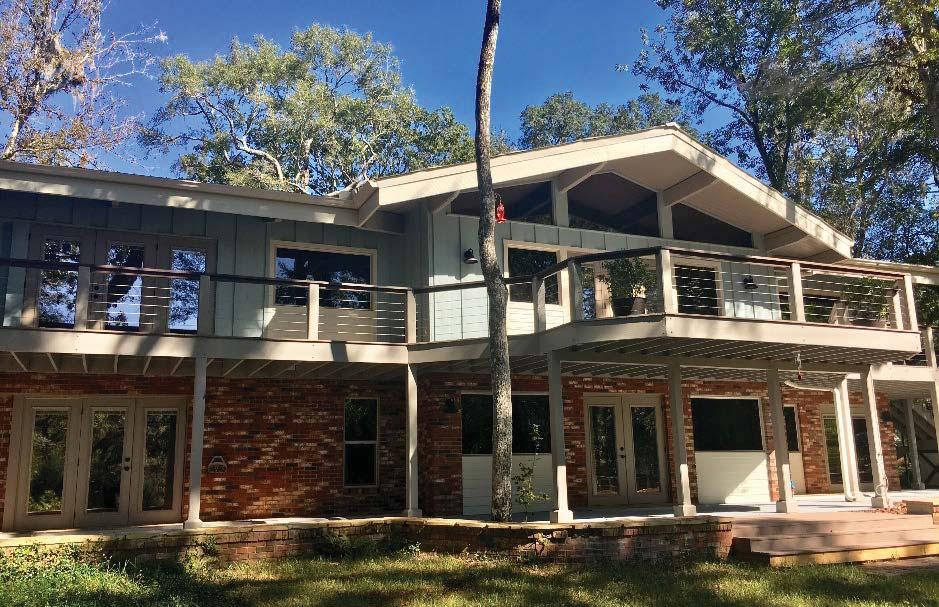
4 Redwine River Ranch Main Home Exterior Photo Summary Charlie Sparks, BROKER


5 Redwine River Ranch Main Home Exterior Photo Summary Charlie Sparks, BROKER


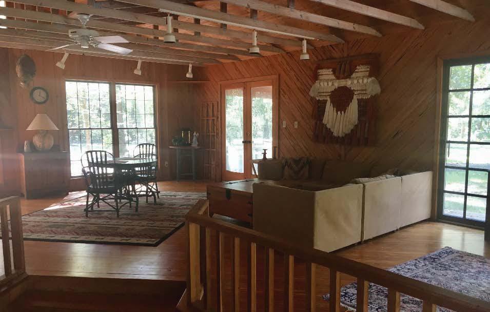
6 Redwine River Ranch Main Home Interior Photo Summary Charlie Sparks, BROKER


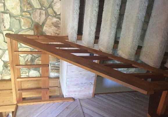
7 Redwine River Ranch Guest Quarters Photo Summary Charlie Sparks, BROKER


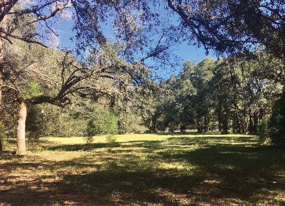
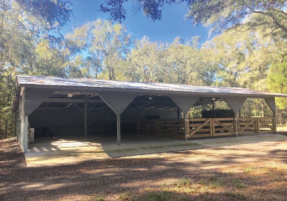
8 Redwine River Ranch Exterior Photo Summary Charlie Sparks, BROKER

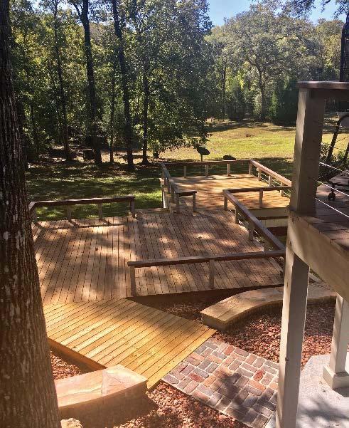
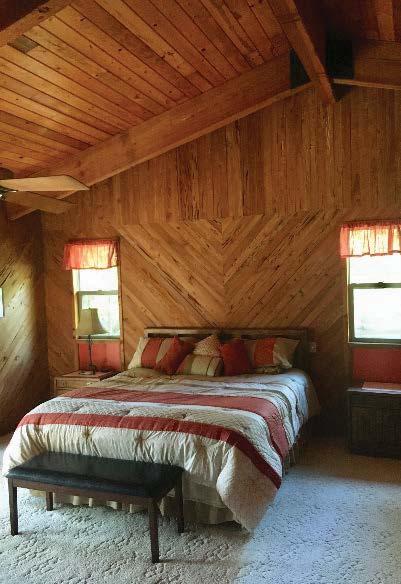
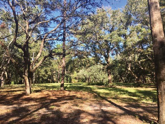
9 Redwine River Ranch Summary This truly unique property features 139+/- acres with pasture areas, towering Oaks and Cypress trees, several nature trails and private roads, a private natural spring / swimming hole, and a 5 acre private island! There are 3 separate homes on the property. Located on a paved road! The Main House: The two-story main home has over 3,700sf of living space and was constructed with reclaimed logs from the Santa Fe River! Beautiful stone fireplaces on both floors and rustic touches throughout! Large windows and skylights provide plenty of natural light and gorgeous views. Ample decking and patio areas to relax and take in the peaceful setting. Large detached 2-car garage with its own half bath. The Guest House: The 1BR/1BA guest home features approximately 1,136 sqft of space. Gorgeous open beam ceilings in the living room and kitchen area. The Stilt House: Cypress-sided 3BR/2BA stilt house with approximately 1,152 sqft of living space. Lovely wrap-around porch. Parking space under home. The current ownership is offering this property for sale at an attractive price of $1,650,000! Aerial View Charlie Sparks, BROKER charlie@charliesparks.com
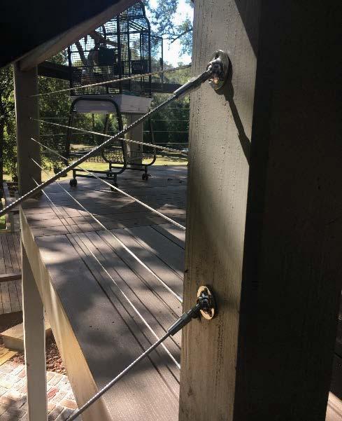
10 Redwine River Ranch Repairs & Improvements Since October 2016 New Metal Standing Seam Roofs All homes $60,800 Post Brackets & repairs, Garage Angle Brackets $2,800 Paint Main House and Garage $5,850 Windows & Doors $53,000 Work Shed $43,000 Decks, Front & Rear $37,500 Deck Repairs Skirting $1,800 Deck Repairs Small Deck $1,300 Deck Repairs Rear Lower Deck $8,300 Pavers $23,500 Deck Railing $11,400 Roof Guest House $6,400 Remove & Replace Fence $27,140 Replace Rocks in Front $11,470 Trees $3,240 Sod $4,400 Tree Removal & Stump Grinding $52,100 Concrete $14,300 Gate $6,000 Millings $6,800 Misc. Labor & Materials $92,000 TOTAL : $473,100 Charlie Sparks, BROKER charlie@charliesparks.com
11 Redwine River Ranch Area Information Fort White is located in southern Columbia County at the intersection of U.S. Hwy 27 and State Road 47. State Road 47 leads north 20 miles to Lake City. The town was incorporated in 1884 and grew steadily following the arrival of the railroad in Phosphate mining, turpentine and agriculture (cotton and oranges) were the foundation of the economy, and the population grew to nearly 2,000. Columbia County is noted for its natural tourist attractions like the Ichetucknee River, Suwannee River, Santa Fe River and a large U.S. Forest. The community has enjoyed good growth over the past two decades and is set for continued growth for years to come. And of course, you cannot say enough good things about the enviable climate in North Central Florida! Nearby Metropolitan City Location Gainesville 32 Jacksonville 80 Tallahassee 123 Distance in Miles Charlie Sparks, BROKER charlie@charliesparks.com
12 Redwine River Ranch Columbia County Demographics Columbia County Florida Population 1990 Census Population 2000 Census Population 2010 Census Population 2015 Projected Population Growth Growth Estimated Median Age 2013 Persons per square mile 42,613 56,513 67,531 69, % 3.5% ,938,071 15,982,824 18,801,332 19,750, % 5% Households 2000 Census Households 2010 Estimated Households Growth Average Household Size 2000 Number of Housing Units 2010 Number of Housing Units Growth ,925 24, % ,579 28, % 6,338,075 7,420,802 17% ,302,947 8,989,580 23% Income 1990 Per Capita Personal Income 2000 Per Capita Personal Income 2010 Per Capita Personal Income 2012 Per Capita Personal Income 2013 Median Household Income 2013 Median Family Income $13,370 $19,273 $27,983 $29,966 $37,534 $44,707 $19,437 $29,079 $38,493 $41,012 $47,309 $57,128 Housing 2000 Occupied Units 2000 Vacant Units 2000 Owner Occupied Units 2000 Renter Occupied Units 2010 Occupied Units 2010 Vacant Units 2010 Owner Occupied Units 2010 Renter Occupied Units 20,925 2,654 16,146 4,779 24,941 3,695 18,213 6,728 6,337, ,018 4,441,799 1,896,130 7,420,802 1,568,778 4,998,979 2,421, New Home Permits 2000 New Home Permits 2010 New Home Permits 2012 New Home Permits , ,269 38,679 64,810 Charlie Sparks, BROKER
13
14
 Interactive GIS Map Print Owner & Property Info Search Result: 1 of 2 Next >> Owner's Name Mailing Address ERB MELVIN J JR & SUSIE PARK (JTWRS) 3401 SW ST LUCIE SHORES DR")
15 Columbia County Property Appraiser updated: 10/12/2017 Parcel: 21-7S << Next Lower Parcel Next Higher Parcel >> 2017 Tax Year Tax Collector Tax Estimator Property Card Parcel List Generator 2017 TRIM (pdf) Interactive GIS Map Print Owner & Property Info Search Result: 1 of 2 Next >> Owner's Name Mailing Address ERB MELVIN J JR & SUSIE PARK (JTWRS) 3401 SW ST LUCIE SHORES DR PALM CITY, FL Site Address 5278 SW COUNTY ROAD 138 Use Desc. (code) SFRES/SFRE (000101) Tax District 3 (County) Neighborhood Land Area ACRES Market Area 02 Description NOTE: This description is not to be used as the Legal Description for this parcel in any legal transaction. ALL OF S1/2 OF SW1/4 LYING NE FLA POWER N R/W LINE EX E 60 FT FOR RD R/W & EX RD R/W FOR SR , ,408, ,455,459, WD , WD , Property & Assessment Values 2017 Certified Values Mkt Land Value cnt: (0) $329, Ag Land Value cnt: (3) $0.00 Building Value cnt: (3) $123, XFOB Value cnt: (5) $32, Total Appraised Value $485, Just Value $485, Class Value $0.00 Assessed Value $485, Exempt Value $0.00 Total Taxable Value Cnty: $485,369 Other: $485,369 Schl: $485,369 Sales History 2018 Working Values (...Hide Values) Mkt Land Value cnt: (0) $329, Ag Land Value cnt: (3) $0.00 Building Value cnt: (3) $123, XFOB Value cnt: (5) $32, Total Appraised Value $485, Just Value $485, Class Value $0.00 Assessed Value $485, Exempt Value $0.00 Total Taxable Value Cnty: $485,369 Other: $485,369 Schl: $485,369 NOTE: 2018 Working Values are NOT certified values and therefore are subject to change before being finalized for ad valorem assessment purposes. Show Similar Sales within 1/2 mile Sale Date OR Book/Page OR Code Vacant / Improved Qualified Sale Sale RCode Sale Price 8/31/ /1889 WD I Q 01 $875, /31/ /887 WD I Q 01 $621, /16/ /444 WD I Q $1,353, /16/ /455 WD V U 02 $106, /16/ /459 WD V U 02 $215, Building Characteristics Bldg Item Bldg Desc Year Blt Ext. Walls Heated S.F. Actual S.F. Bldg Value 2 SFR PILING (000300) 1983 AVERAGE (05) $60, SINGLE FAM (000100) 1984 ABOVE AVG. (10) $46, SFR MANUF (000200) 1994 ABOVE AVG. (31) $15, Note: All S.F. calculations are based on exterior building dimensions. Extra Features & Out Buildings Code Desc Year Blt Value Units Dims Condition (% Good) 0040 BARN,POLE 0 $1, x 60 x 0 AP (050.00) 0080 DECKING 0 $ x 15 x 0 AP (050.00) 0166 CONC,PAVMT 0 $ x 24 x 0 (000.00) 0260 PAVEMENT-A 2003 $19, x 10 x 0 AP (010.00)
16 0040 BARN,POLE 2003 $9, x 64 x 0 (000.00) Land Breakdown Lnd Code Desc Units Adjustments Eff Rate Lnd Value SFR (MKT) 50 AC 1.00/1.00/1.00/1.00 $5, $263, AC NON-AG (MKT) AC 1.00/1.00/1.00/1.00 $2, $64, WELL/SEPT (MKT) 1 UT - ( AC) 1.00/1.00/1.00/1.00 $2, $2, Columbia County Property Appraiser updated: 10/12/ of 2 Next >> DISCLAIMER This information was derived from data which was compiled by the Columbia County Property Appraiser Office solely for the governmental purpose of property assessment. This information should not be relied upon by anyone as a determination of the ownership of property or market value. No warranties, expressed or implied, are provided for the accuracy of the data herein, it's use, or it's interpretation. Although it is periodically updated, this information may not reflect the data currently on file in the Property Appraiser's office. The assessed values are NOT certified values and therefore are subject to change before being finalized for ad valorem assessment purposes. Columbia County Property Appraiser Jeff Hampton - Lake City, Florida by: GrizzlyLogic.com
17 Columbia County Property Appraiser Jeff Hampton - Lake City, Florida PARCEL: 21-7S SFRES/SFRE (000101) ALL OF S1/2 OF SW1/4 LYING NE FLA POWER N R/W LINE EX E 60 FT FOR RD R/W & EX RD R/W FOR SR , ,408, ,455,459, WD , Name: ERB MELVIN J JR & Site: 5278 SW COUNTY ROAD 138 SUSIE PARK (JTWRS) Mail: 3401 SW ST LUCIE SHORES DR PALM CITY, FL Sales Info 8/31/2016 $875, I / Q 3/31/2015 $621, I / Q 2017 Certified Values Land $329, Bldg $123, Assd $485, Exmpt $0.00 Taxbl Cnty: $485,369 Other: $485,369 Schl: $485,369 NOTES: This information,updated: 10/12/2017, was derived from data which was compiled by the Columbia County Property Appraiser Office solely for the governmental purpose of property assessment. This information should not be relied upon by anyone as a determination of the ownership of property or market value. No warranties, expressed or implied, are provided for the accuracy of the data herein, it's use, or it's interpretation. Although it is periodically updated, this information may not reflect the data currently on file in the Property Appraiser's office. The assessed values are NOT certified values and therefore are subject to change before being finalized for ad valorem assessment purposes.
18 Columbia County Tax Collector Tax Record generated on 10/26/ :21:28 AM EDT Last Update: 10/26/ :21:27 AM EDT Ad Valorem Taxes and Non-Ad Valorem Assessments The information contained herein does not constitute a title search and should not be relied on as such. Account Number Tax Type Tax Year R REAL ESTATE 2016 Mailing Address LAKE CITY ASSOCIATES, LLC 575 LEXINGTON 515 E 86TH ST APT 6WE NEW YORK NY Property Address 5278 COUNTY ROAD 138 SW FORT WHITE GEO Number 217S Exempt Amount See Below Taxable Value See Below Exemption Detail Millage Code Escrow Code NO EXEMPTIONS 003 Legal Description (click for full description) 21-7S / Acres ALL OF S1/2 OF SW1/4 LYING NE FLA POWER N R/W LINE EX E 60 FT FOR RD R/W & EX RD R/W FOR SR-138, ORB , , ORB , ORB , ORB , WD , Taxing Authority Ad Valorem Taxes Rate Assessed Value Exemption Amount Taxable Value Taxes Levied BOARD OF COUNTY COMMISSIONERS ,771 0 $484,771 $3, COLUMBIA COUNTY SCHOOL BOARD DISCRETIONARY ,771 0 $484,771 $ LOCAL ,771 0 $484,771 $2, CAPITAL OUTLAY ,771 0 $484,771 $ SUWANNEE RIVER WATER MGT DIST ,771 0 $484,771 $ LAKE SHORE HOSPITAL AUTHORITY ,771 0 $484,771 $ Total Millage Total Taxes $7, Non-Ad Valorem Assessments Code Levying Authority Amount FFIR FIRE ASSESSMENTS $ GGAR SOLID WASTE - ANNUAL $ Total Assessments $ Taxes & Assessments $8, If Paid By Amount Due $0.00 Date Paid Transaction Receipt Item Amount Paid 12/16/2016 PAYMENT $8,284.58
 Interactive GIS Map Print Owner & Property Info Search Result: 1 of 2 Next >> Owner's Name Mailing Address ERB MELVIN J JR & SUSIE PARK (JTWRS) 3401 SW ST LUCIE SHORES DR")
19 Columbia County Property Appraiser updated: 10/12/2017 Parcel: 28-7S << Next Lower Parcel Next Higher Parcel >> 2017 Tax Year Tax Collector Tax Estimator Property Card Parcel List Generator 2017 TRIM (pdf) Interactive GIS Map Print Owner & Property Info Search Result: 1 of 2 Next >> Owner's Name Mailing Address ERB MELVIN J JR & SUSIE PARK (JTWRS) 3401 SW ST LUCIE SHORES DR PALM CITY, FL Site Address 5276 SW COUNTY ROAD 138 Use Desc. (code) SINGLE FAM (000100) Tax District 3 (County) Neighborhood Land Area ACRES Market Area 02 Description NOTE: This description is not to be used as the Legal Description for this parcel in any legal transaction. ALL OF GOV'T LOT 2 LYING NE OF FLORIDA POWER'S N R/W LINE , , , WD , WD , Property & Assessment Values 2017 Certified Values Mkt Land Value cnt: (0) $160, Ag Land Value cnt: (2) $0.00 Building Value cnt: (1) $199, XFOB Value cnt: (4) $13, Total Appraised Value $373, Just Value $373, Class Value $0.00 Assessed Value $373, Exempt Value $0.00 Total Taxable Value Cnty: $373,182 Other: $373,182 Schl: $373,182 Sales History 2018 Working Values (...Hide Values) Mkt Land Value cnt: (0) $160, Ag Land Value cnt: (2) $0.00 Building Value cnt: (1) $199, XFOB Value cnt: (4) $13, Total Appraised Value $373, Just Value $373, Class Value $0.00 Assessed Value $373, Exempt Value $0.00 Total Taxable Value Cnty: $373,182 Other: $373,182 Schl: $373,182 NOTE: 2018 Working Values are NOT certified values and therefore are subject to change before being finalized for ad valorem assessment purposes. Show Similar Sales within 1/2 mile Sale Date OR Book/Page OR Code Vacant / Improved Qualified Sale Sale RCode Sale Price 8/31/ /1889 WD I Q 01 $875, /31/ /887 WD I Q 01 $621, /16/ /444 WD I Q $1,353, /16/ /455 WD V U 02 $106, Building Characteristics Bldg Item Bldg Desc Year Blt Ext. Walls Heated S.F. Actual S.F. Bldg Value 1 SINGLE FAM (000100) 1978 COMMON BRK (19) $199, Note: All S.F. calculations are based on exterior building dimensions. Extra Features & Out Buildings Code Desc Year Blt Value Units Dims Condition (% Good) 0260 PAVEMENT-A 1993 $6, x 10 x 0 AP (010.00) 0170 FPLC 2STRY 1993 $2, x 0 x 0 (000.00) 0166 CONC,PAVMT 1993 $1, x 38 x 0 (000.00) 0080 DECKING 1993 $2, x 0 x 0 AP (050.00) Land Breakdown Lnd Code Desc Units Adjustments Eff Rate Lnd Value
20 AC NON-AG (MKT) AC 1.00/1.00/1.00/1.00 $2, $157, SFR (MKT) 1 AC 1.00/1.00/1.00/1.00 $2, $2, Columbia County Property Appraiser updated: 10/12/ of 2 Next >> DISCLAIMER This information was derived from data which was compiled by the Columbia County Property Appraiser Office solely for the governmental purpose of property assessment. This information should not be relied upon by anyone as a determination of the ownership of property or market value. No warranties, expressed or implied, are provided for the accuracy of the data herein, it's use, or it's interpretation. Although it is periodically updated, this information may not reflect the data currently on file in the Property Appraiser's office. The assessed values are NOT certified values and therefore are subject to change before being finalized for ad valorem assessment purposes. Columbia County Property Appraiser Jeff Hampton - Lake City, Florida by: GrizzlyLogic.com
 Mail: 3401 SW ST LUCIE SHORES DR PALM CITY, FL 34990 Sales 8/31/2016")
21 Columbia County Property Appraiser Jeff Hampton - Lake City, Florida PARCEL: 28-7S SINGLE FAM (000100) ALL OF GOV'T LOT 2 LYING NE OF FLORIDA POWER'S N R/W LINE , , , WD , WD , Name: ERB MELVIN J JR & Site: 5276 SW COUNTY ROAD 138 SUSIE PARK (JTWRS) Mail: 3401 SW ST LUCIE SHORES DR PALM CITY, FL Sales 8/31/2016 $875, I / Q Info 3/31/2015 $621, I / Q 2017 Certified Values Land $160, Bldg $199, Assd $373, Exmpt $0.00 Taxbl Cnty: $373,182 Other: $373,182 Schl: $373,182 NOTES: This information,updated: 10/12/2017, was derived from data which was compiled by the Columbia County Property Appraiser Office solely for the governmental purpose of property assessment. This information should not be relied upon by anyone as a determination of the ownership of property or market value. No warranties, expressed or implied, are provided for the accuracy of the data herein, it's use, or it's interpretation. Although it is periodically updated, this information may not reflect the data currently on file in the Property Appraiser's office. The assessed values are NOT certified values and therefore are subject to change before being finalized for ad valorem assessment purposes.
22 Columbia County Tax Collector Tax Record generated on 10/26/ :22:19 AM EDT Last Update: 10/26/ :22:19 AM EDT Ad Valorem Taxes and Non-Ad Valorem Assessments The information contained herein does not constitute a title search and should not be relied on as such. Account Number Tax Type Tax Year R REAL ESTATE 2016 Mailing Address LAKE CITY ASSOCIATES, LLC 315 E 86TH ST APT 6WE NEW YORK NY Property Address COUNTY ROAD S GEO Number 287S Exempt Amount See Below Taxable Value See Below Exemption Detail Millage Code Escrow Code NO EXEMPTIONS 003 Legal Description (click for full description) 28-7S / Acres ALL OF GOV'T LOT 2 LYING NE OF FLORIDA POWER'S N R/W LINE. ORB , ORB , , WD , Taxing Authority Ad Valorem Taxes Rate Assessed Value Exemption Amount Taxable Value Taxes Levied BOARD OF COUNTY COMMISSIONERS ,427 0 $374,427 $3, COLUMBIA COUNTY SCHOOL BOARD DISCRETIONARY ,427 0 $374,427 $ LOCAL ,427 0 $374,427 $1, CAPITAL OUTLAY ,427 0 $374,427 $ SUWANNEE RIVER WATER MGT DIST ,427 0 $374,427 $ LAKE SHORE HOSPITAL AUTHORITY ,427 0 $374,427 $ Total Millage Total Taxes $6, Non-Ad Valorem Assessments Code Levying Authority Amount FFIR FIRE ASSESSMENTS $ GGAR SOLID WASTE - ANNUAL $ Total Assessments $ Taxes & Assessments $6, If Paid By Amount Due $0.00 Date Paid Transaction Receipt Item Amount Paid 12/16/2016 PAYMENT $6,213.76
: Yes Flood Zone(s): X 0.2 PCT, AE Floodway: No 1% Annual Chance Flood Elev (BFE): 36 (feet) 10% Annual Chance Flood Elev: 30.")
23 Suwannee River Water Management District Effective Flood Information Report LOCATION Date: Parcel: 21-7S County: STR: COLUMBIA S028 T07 R16 Columbia Flood Hazard Areas Status E ffective: 02/04/2009 FLOOD INFORMATION Special Flood Hazard Area? (SFHA): Yes Flood Zone(s): X 0.2 PCT, AE Floodway: No 1% Annual Chance Flood Elev (BFE): 36 (feet) 10% Annual Chance Flood Elev: 30.5 (feet) 50% Annual Chance Flood Elev: 27.3 (feet) Note: Elevations are based on NAVD88 FIRM Panel(s): 12023C0526C, 12023C0527C The Federal Emergency Managem ent Agency (FEMA) maintains information about m ap features, such as street locations and names, in or near designated flood hazard areas. The information herein represents the best available data as of the effective date shown. The applicable Flood Insurance Study and a Digital Flood Insurance Rate Map is available online ( To obtain m ore detailed information in areas where Base Flood Elevations (BFEs) and/or floodways have been determined, users are encouraged to also consult the FEMA Map Service Center at ( for information on available products associated with this FIRM panel. Available products from the Map Service Center may include previously issued Letters of Map Change. Requests to revise flood information in or near designated flood hazard areas m ay be provided to FEMA during the community review period on preliminary m aps, or through the Letter of Map Change process for effective maps.
: Yes Flood Zone(s): AE FW, X 0.2 PCT Floodway: Yes 1% Annual Chance Flood Elev (BFE): 36.")
24 Suwannee River Water Management District Effective Flood Information Report LOCATION Date: Parcel: 28-7S County: STR: COLUMBIA S028 T07 R16 Columbia Flood Hazard Areas Status E ffective: 02/04/2009 FLOOD INFORMATION Special Flood Hazard Area? (SFHA): Yes Flood Zone(s): AE FW, X 0.2 PCT Floodway: Yes 1% Annual Chance Flood Elev (BFE): 36.2 (feet) 10% Annual Chance Flood Elev: 30.6 (feet) 50% Annual Chance Flood Elev: 27.4 (feet) Note: Elevations are based on NAVD88 FIRM Panel(s): 12023C0526C, 12023C0527C The Federal Emergency Managem ent Agency (FEMA) maintains information about m ap features, such as street locations and names, in or near designated flood hazard areas. The information herein represents the best available data as of the effective date shown. The applicable Flood Insurance Study and a Digital Flood Insurance Rate Map is available online ( To obtain m ore detailed information in areas where Base Flood Elevations (BFEs) and/or floodways have been determined, users are encouraged to also consult the FEMA Map Service Center at ( for information on available products associated with this FIRM panel. Available products from the Map Service Center may include previously issued Letters of Map Change. Requests to revise flood information in or near designated flood hazard areas m ay be provided to FEMA during the community review period on preliminary m aps, or through the Letter of Map Change process for effective maps.
25 Base Flood Elevation (BFE) The elevation shown on the Flood Insurance Rate Map for Zones AE, AH, A1-A30, AR, AO, V1-V30, and VE that indicates the water surface elevation resulting from a flood that has a one percent chance of equaling or exceeding that level in any given year. A Areas with a 1% annual chance of flooding and a 26% chance of flooding over the life of a 30-year mortgage. Because detailed analyses are not performed for such areas; no depths or base flood elevations are shown within these zones. AE, A1-A30 Areas with a 1% annual chance of flooding and a 26% chance of flooding over the life of a 30-year mortgage. In most instances, base flood elevations derived from detailed analyses are shown at selected intervals within these zones. AH Areas with a 1% annual chance of flooding and a 26% chance of flooding over the life of a 30-year mortgage. Usually areas of ponding with flood depths of 1 to 3 feet. Base Flood Elevations are determined. AO Areas with a 1% annual chance of flooding and a 26% chance of flooding over the life of a 30-year mortgage. Usually areas of sheet flow on sloping terrain with flood depths of 1 to 3 feet. Base Flood Elevations are determined. Supplemental Information: 10%-chance flood elevations (10-year flood-risk elevations) and 50%-chance flood elevations (2-year flood-risk elevations), are calculated during detailed flooding studies but are not shown on FEMA Digital Flood Insurance Rate Maps (FIRMs). They have been provided as supplemental information in the Flood Information section of this report. AE FW (FLOODWAYS) The channel of a river or other watercourse and the adjacent land areas that must be reserved in order to discharge the base flood (1% annual chance flood event). The floodway must be kept open so that flood water can proceed downstream and not be obstructed or diverted onto other properties. Please note, if you develop within the regulatory floodway, you will need to contact your Local Government and the Suwannee River Water Management District prior to commencing with the activity. Please contact the District at VE Areas with a 1% annual chance of flooding over the life of a 30-year mortgage with additional hazards due to storm-induced velocity wave action. Base Flood Elevations (BFEs) derived from detailed analyses. X 0.2 PCT (X Shaded, 0.2 PCT ANNUAL CHANCE FLOOD HAZARD) Same as Zone X; however, detailed studies have been performed, and the area has been determined to be within the 0.2 percent annual chance floodplain (also known as the 500-year flood zone). Insurance purchase is not required in this zone but is available at a reduced rate and is recommended. X All areas outside the 1-percent annual chance floodplain are Zone X. This includes areas of 1% annual chance sheet flow flooding where average depths are less than 1 foot, areas of 1% annual chance stream flooding where the contributing drainage area is less than 1 square mile, or areas protected from the 1% annual chance flood by levees. No Base Flood Elevations or depths are shown within this zone. Insurance purchase is not required in these zones. LINKS FEMA: SRWMD: CONTACT SRWMD 9225 County Road 49 Live Oak, FL (386) Toll Free: (800)
26 SITE ANALYSIS Location The subject property is located on the southwest corner of Southwest County Road 138 and Southwest Horseshoe Loop and along the northern bank of the Santa Fe River. The subject property is further situated approximately five miles south of the Town of Fort White in extreme southern Columbia County, Florida. Site Description Present Use: Heavily wooded rural residential/recreational land. Size: acres Shape: Irregular in shape. See included map showing boundary lines. Water Frontage: The subject property contains 2,400 feet of frontage along the northern bank of the Santa Fe River. Topography: According to a review of GIS Mapping available from the National Wetlands Inventory, the subject property contains approximately 41 acres (29% of the total property area) of probable jurisdictional wetlands. Wetland areas are concentrated in the southern portion of the tract and coincide with the parcel s frontage along the Santa Fe River. Topographical maps indicate that the subject property is generally level but slopes slightly downward from northeast to southwest toward the aforementioned wetland areas and the Santa Fe River. Vegetation: The bulk of the subject property mainly consists of areas of mixed forest with a variety of natural vegetation indigenous to this region of Florida. The northern portion of the tract is partially cleared with scattered mature trees and is currently utilized as grazing land. Soil Conditions: The site is presumed to have an adequate load-bearing capacity for development purposes as evidenced by surrounding improvements. Also, no surface or subsurface hazardous materials or other contaminants are presumed on or in the site. However, engineering test borings were not performed by the appraiser and no warranties are given by the appraiser concerning engineering of the site. As mentioned previously, the subject property contains approximately 41 acres of probable jurisdictional wetlands. Due to engineering problems inherent with construction in areas of this type, it is assumed by the appraiser that either no construction will take place in these areas or that adequate measures, including further testing, will be undertaken prior to development. Flood Map Classification: According to flood hazard mapping available through the Suwannee River Water Management District, approximately 30% of the subject property is situated within Flood Hazard Zone X (unshaded). Unshaded areas of Flood Hazard Zone X are defined as areas of minimal risk outside the one-percent and 0.2-percent-annual-chance floodplains. No base flood elevations or base flood depths are shown within these zones. 31
27 SITE ANALYSIS (Continued) Areas of the subject property primarily associated with its frontage along the Santa Fe River are situated in the shaded areas of Flood Hazard Zone X (70% of the total property area), Flood Hazard Zone AE (62% of the total property area), and the Floodway of the Santa Fe River (18% of the total property area). Shaded areas of Flood Hazard Zone X are defined as areas of moderate risk within the 0.2-percent-annual-chance floodplain, areas of one-percent-annual-chance flooding where average depths are less than one foot, areas of one-percent-annual-chance flooding where the contributing drainage area is less than one square mile, and areas protected from the one-percent-annual-chance flood by a levee. No base flood elevations or base flood depths are shown within these zones. Flood Hazard Zone AE is defined as areas subject to inundation by the one-percent-annual-chance flood event determined by detailed methods. Base flood elevations are shown within these zones. A Base Flood Elevation is the computed elevation to which floodwater is anticipated to rise during the base flood. For the subject property, a Base Flood Elevation of approximately 36 feet is indicated. Finally, a "Regulatory Floodway" means the channel of a river or other watercourse and the adjacent land areas that must be reserved in order to discharge the base flood without cumulatively increasing the water surface elevation more than a designated height. Communities must regulate development in these floodways to ensure that there are no increases in upstream flood elevations. A copy of the Flood Insurance Rate Map showing the flood zones discussed above in relation to the subject property is provided on the following page. Access: Primary access and exposure is provided to the subject property via approximately 896 feet of frontage along south side of County Road 138. County Road 138 represents a secondary east-west thoroughfare for this portion of Columbia County and contains two asphalt paved traffic lanes. Additional access is provided via approximately 1,563 feet of frontage along the west side of Southwest Horseshoe Loop, a two lane unimproved graded roadway. Utilities and Public Services: The improvements on the subject utilize private wells and septic systems for water and sanitary sewer. Columbia County provides police protection and rescue and fire services, and trash removal is provided by private contractors. Electricity and telephone service are also available to the site. The available utilities and public services are considered adequate for the subject under its highest and best use. Existing Crops, Pasture, etc.: The subject property consists of a ± acre parcel of recreational and rural residential land containing areas of partially cleared native grazing land and dense natural vegetation with a variety of species indigenous to this and similar ecosystems of this region of Florida. No crops or improved pastures are located on the subject property. 32
28 SITE ANALYSIS (Continued) Outstanding Rights and/or Possessory Interests Easements and Other Restrictions: According to limited research provided to the appraiser and a review of available satellite imagery, the subject property is assumed to be encumbered by a transmission line easement granted to the Florida Power Corporation. Because of the limited encumbered area and its situation along the western boundary of the subject property, this encumbrance is not considered to have any adverse impact on the functional utility and/or market value of the subject property. No other easements, having an adverse affect on market value, are noted on the subject property. Existing Leases, Rentals, or Use Agreements: The subject property is not known to be encumbered by any existing leases, rentals, or use agreements having an adverse affect on market value, and is not rented nor is there a rental history. Life Estate: The subject property is not known to be encumbered by a life estate. Outstanding Oil, Gas, and Mineral Rights: No outstanding oil, gas, and/or mineral rights noted on the subject property. Zoning and Other Land Use Regulations Zoning Designation: According to the Columbia County Planning and Zoning Department, the majority of the subject parcel, associated primarily with the aforementioned flood prone areas, is zoned ESA-2, Environmentally Sensitive Areas, with a minority portion located in the A-3, Agricultural, district. Lands in the ESA-2 district are considered in need of special planning and treatment regarding land development regulation. This is not a preservation district, but land uses permitted within this district are to provide mitigating measures to protect the natural functions of areas which are limited to the planning and treatment of land development within the 100-year floodplain of the Ichetucknee Springs State Park, O'Leno State Park, Osceola National Forest, Pinhook Swamp, Suwannee River Corridor, Santa Fe River Corridor, and Ichetucknee Trace, as designated within the Federal Emergency Management Agency flood insurance rate map for the county. These regulations prohibit intensive residential, intensive recreational, and intensive agricultural uses and prohibit industrial and commercial development within the 100-year floodplain of the areas designated as environmentally sensitive areas. Primary permitted uses and structures within the ESA-2 district include: Non-intensive agricultural and forestry operations, single-family dwellings, mobile homes, homes of six or fewer residents which otherwise meet the definition of a "community residential facility", public resource based recreation facilities, churches and other houses of worship. Intensive agricultural development means those agricultural land uses requiring an industrial waste permit from the Florida Department of Environmental Protection. Development in this district is permitted to a minimum lot area of ten acres. 34
29 SITE ANALYSIS (Continued) Lands in the A-3 district are intended to provide for areas primarily consisting of agricultural and residential uses consistent with the areas as designated agricultural within the county s comprehensive plan. Primary permitted uses and structures within the A-3 district include: all agricultural activities (but not including livestock or poultry slaughterhouses), single family dwellings, mobile homes, plant nurseries and greenhouses, homes of six or fewer residents which otherwise meet the definition of community residential facility, public elementary and middle schools, churches and other houses of worship, cemeteries, travel trailers, and landscape services. Development in this district is permitted to a minimum lot area of five acres. The requirements and restrictions under the zoning ordinance are reasonable and typical of similar zoning ordinances in other local communities. For the government body, land use plans serve as generalized guidelines for both current and future development. Items generally included in guidelines are use classifications, use intensity, and preservation areas. The land use plan is generally used in conjunction with existing zoning when a proposed development is being reviewed by the government authority. The subject parcel was reported to have land use designations which are in agreement with the current zoning designations. Environmental Regulations: Its inclusion of approximately 41 acres, or approximately 29% of the total property acreage, of probable jurisdictional wetlands, restricts the development of the subject property through environmental regulations currently in place in the subject area. The Suwannee River Water Management District, the Florida Department of Environmental Protection, and the US Army Corps of Engineers, the governing bodies on wetland regulation in the subject area, tend to highly discourage any development in designated wetland areas, thus making it infeasible for any intensive use in these areas. Also, zoning regulations placed on flood zone areas, in which a portion of the subject property is located, further restrict the type and construction of improvements in designated flood zones. No other environmental regulations having an impact on market value are known or presumed in this analysis. 35
30 Sec "ESA" environmentally sensitive areas Districts and intent. The "ESA" environmentally sensitive area category includes three zone districts: ESA-1, 2, 3. Lands in these districts are considered in need of special planning and treatment regarding land development regulation. These are not preservation districts, but land uses permitted within these districts are to provide mitigating measures to protect the natural functions of areas which are limited to the planning and treatment of land development within the 100-year floodplain of the Ichetucknee Springs State Park, O'Leno State Park, Osceola National Forest, Pinhook Swamp, Suwannee River Corridor, Santa Fe River Corridor and Ichetucknee Trace, as designated within the Federal Emergency Management [Agency] flood insurance rate map for the county, as amended. These regulations prohibit intensive residential, intensive recreational and intensive agricultural uses and prohibit industrial and commercial development within the 100-year floodplain of the areas designated as environmentally sensitive areas Permitted principal uses and structures. 1. Non-intensive agricultural (see definition of intensive agriculture in section 2.1) and forestry operations conducted in accordance with Silviculture Best Management Practices Manual, published by the Florida Department of Agriculture and Consumer Services, Division of Forestry, Revision May Single-family dwellings. 3. Mobile homes. 4. Homes of six or fewer residents which otherwise meet the definition of a "community residential facility." (See section 4.2.) 5. Public resource based recreation facilities. 6. Churches and other houses of worship. (Ord. No , 4, ) Permitted accessory uses and structures. 1. Uses and structures which: a. Are customarily accessory and clearly incidental and subordinate to permitted or permissible uses and structures; b. Are located on the same lot as the permitted or permissible principal use or structure, or on a contiguous lot in the same ownership; and c. Do not involve operations or structures not in keeping with the intent of these land development districts. 2. Examples of permitted accessory uses and structures include: a. Private garages. b. Docks, ramps, piers and walkways for residential and water-dependent commercial uses (See article 14).
31 c. Residential facilities for caretakers whose work requires residence on the premises or for employees who will be quartered on the premises Prohibited uses and structures. Industrial and commercial uses, intensive agricultural uses (See section 2.1 for definition of intensive agriculture), private recreational uses and any use or structure not specifically, provisionally, or by reasonable implication permitted herein or permissible as a special exception Special exceptions. (See also articles 12 and 13). 1. Home occupations. 2. Campgrounds of less than 100 campsites, provided that such campgrounds are no located within five miles from another campground, which is also located within an environmentally sensitive area and not more than 20 percent of the natural vegetation on each campsite within such campgrounds shall be removed. 3. Bottled-water plant. 4. Other similar uses, which are consistent with the uses within this district Minimum lot requirements (area, width). 1. Single-family dwellings and mobile homes: ESA- 1 Minimum lot area: 40 acres. Minimum lot width: 400 feet. ESA- 2 Minimum lot area: ten acres. Minimum lot width: 400 feet (five acres if developed as a planned rural residential development and an overall density of one dwelling unit per ten acres is maintained on site). ESA- 3 Minimum lot area: five acres. Minimum lot width: 275 feet. Note: Minimum lot areas for any portions of the area designated as environmentally sensitive which is outside of the 100- year floodplain as designated by the Federal Emergency Management Agency flood insurance rate map shall conform with the following minimum lot requirements of the abutting zoning district. If there is more than one abutting zoning district, excepting conservation, the minimum lot requirements shall conform with the more restrictive district. 2. All other permitted or permissible uses and structures (unless otherwise specified).
32 Minimum lot area. Ten acres. Minimum lot width. 400 feet Minimum yard requirements (depth of front and rear yard, width of side yard) (See section 4.2 for right-of-way setback requirements.) 1. All permitted or permissible uses and structures (unless otherwise specified): Front: 30 feet. Side: 25 feet. Rear: 25 feet. Special provisions. The location of any structure (except permitted docks, walkways, and piers) shall be set back a minimum of 35 feet from wetlands. The location of any structure (except permitted docks, walkways, and piers) shall be set back a minimum of 75 feet from the Suwannee, Santa Fe and Ichetucknee Rivers. The location of any structure (except permitted docks, walkways, and piers) shall be set back a minimum of 50 feet from all other perennial rivers, streams and creeks Maximum height of structures: No portion shall exceed: 35 feet. (See section 4.2 for exclusions from height limitation.) Maximum lot coverage by all buildings. 20 percent. Note: In addition to meeting the required lot yard, building height, lot coverage, landscaped buffering, and off-street parking requirements of this section, no structure shall exceed a 1.0 floor area ratio Minimum landscaped buffering requirements. 1. All permitted or permissible uses and structures (unless otherwise specified). None, except as necessary to meet other requirements as set out herein Minimum off-street parking requirements. 1. Each residential dwelling unit. Two spaces for each dwelling unit. 2. For all other uses and special exceptions as specified herein. To be determined by findings in the particular case.
33 Sec "A" Agricultural Districts and intent. The "A" Agricultural category includes three zone districts: A-1, A-2 and A-3. Lands in these districts are intended to provide for areas primarily consisting of agricultural and residential uses consistent with the areas as designated agricultural within the county's comprehensive plan. Permitted principal uses and structures within Agriculture-1 and Agriculture-2 districts. 1. All agricultural activities (but not including livestock or poultry slaughterhouses), including the raising of livestock and poultry, the production of dairy and poultry products, the cultivation of field crops and fruits and berries, forestry, apiculture, and similar uses; provided, that no structure used for housing of animals or any commercial feed lot operation shall be located within 300 feet of any lot line, and no structure used for housing domestic animals shall be located within 100 feet of any lot line. 2. The processing, storage, and sale of agricultural products and commodities which are raised on the premises (but not including livestock or poultry slaughterhouses); provided that no building used for these activities shall be located within 300 feet of any side or rear lot line. 3. Single-family dwellings. 4. Mobile homes. 5. Plant nurseries and greenhouses. 6. Homes of six or fewer residents which otherwise meet the definition of a "community residential facility." (See section 4.2.) 7. Public elementary and middle schools. (See sections 4.2 and ) 8. Churches and other houses of worship. 9. Cemeteries not requiring licensure of the State of Florida 10. Landscape services including yard maintenance firms.
34 (Ord. No , 5, ) Permitted accessory uses and structures within Agriculture-1 and Agriculture-2 districts. 1. Uses and structures which: a. Are customarily accessory and clearly incidental and subordinate to permitted uses and structures. b. Are located on the same lot as the permitted principal use or structure or on a contiguous lot in the same ownership. 2. Examples of permitted accessory uses and structures include: a. Barns and stables. b. Private garages. c. Private swimming pools. d. On-site signs. (See section 42.) e. Residential facilities for caretakers whose work requires residence on the premises or for employees who will be quartered on the premises. Prohibited uses and structures within Agriculture-1, -2 and Agriculture-3 districts. Junk yard or automobile wrecking yard, any use or structure requiring an industrial waste permit issued by the Florida Department of Environmental Protection located within areas designated as high groundwater aquifer recharge on illustration A-XI entitled Natural Groundwater Aquifer Recharge Areas found within the county's Comprehensive Plan, any mining use or structure not located within areas designated as mining areas on illustration A-X, entitled Mining Areas found within the county'[s] comprehensive plan and any use or structure not specifically, provisionally or by reasonable implication permitted herein as a special exception. Permitted principal uses and structures within Agriculture-3 districts. 1. All agricultural activities (except intensive agricultural uses as defined in section 2.1 herein within high groundwater aquifer recharge areas as defined within the county's comprehensive plan), including the raising of livestock and poultry, the production of dairy and poultry products (but not including livestock or poultry slaughterhouses), the cultivation of field crops and fruits and berries, forestry, in accordance with the comprehensive plan, apiculture, and similar uses; provided, that no structure used for housing of animals or any commercial feed lot operation shall be located within 300 feet of any lot line, and no structure used for housing domestic animals shall be located within 100 feet of any lot line.
35 2. The processing, storage, and sale of agricultural products and commodities which are raised on the premises (but not including livestock or poultry slaughterhouses); provided that no building used for these activities shall be located within 300 feet of any side or rear lot line. 3. Single-family dwellings. 4. Mobile homes. 5. Plant nurseries and greenhouses. 6. Homes of six or fewer residents which otherwise meet the definition of a "community residential facility." (See section 4.2). 7. Public elementary and middle schools. (See sections 4.2 and ) 8. Churches and other houses of worship. 9. Cemeteries not requiring licensure of the State of Florida. 10. Landscape services including yard maintenance firms. (Ord. No , 6, ) Permitted accessory uses and structures within Agriculture-3 districts. 1. Uses and structures in all Agricultural-1 [Agriculture-1] and Agricultural-2 [Agriculture- 2] zoning districts which: a. Are customarily accessory and clearly incidental and subordinate to permitted uses and structures. b. Are located on the same lot as the permitted principal use or structure or on a contiguous lot in the same ownership. c. Do not involve operations not in keeping with the character of a rural area. 2. Examples of permitted accessory uses and structures include: a. Barns and stables. b. Private garages. c. Private swimming pools. d. On-site signs (See Section 4.2). e. Residential facilities for caretakers whose work requires residence on the premises or for employees who will be quartered on the premises.
36 4.5.7 Special exceptions within Agriculture-1, Agriculture-2 and Agriculture-3 districts. (See also articles 12 and 13.) 1. The processing, storage, and sale of agricultural products and commodities which are not raised on the premises; provided, that no building used for these activities shall be located within 150 feet of any side or rear lot line. 2. Livestock auction arenas and general merchandise auction houses. 3. Livestock or poultry slaughterhouses; provided, that no building used for these activities shall be located within 150 feet of any lot line. 4. Heavy equipment and related machinery sales. 5. Agricultural feed and grain packaging, blending, storage, and sales. 6. Agricultural fertilizer storage and sales. 7. Agricultural fairs and fairground activities. 8. Recreational activities such as racetracks and speedways; golf courses; country clubs; tennis and racquet clubs; golf and archery ranges; rifle, shotgun, and pistol ranges; travel trailer parks or campgrounds, including day camps; hunting or fishing camps; and similar uses. 9. Riding or boarding stables; provided that no building used for housing of animals shall be located within 150 feet of any lot line. 10. Drive-in theaters (see section 4.2 for special design standards). 11. Hospitals, sanitariums, nursing homes, and residential homes for the aged and residential facilities for the aged. 12. Commercial kennels, veterinary clinics, and animal shelters; provided, that no open runs or buildings used for housing of animals shall be located within 150 feet of any lot line. 13. Group living facilities.
Professional Office Building
 Professional Office Building 197 SW Waterford Court, Lake City, FL Presented by: Charlie Sparks BROKER 386-755-0808 charlie@charliesparks.com Sale Price: $579,000 Zoning: Commercial Land Size: 3.04 Acres
Development Site For Sale SW SR 47, Lake City, FL
 Development Site For Sale SW SR 47, Lake City, FL Presented by: Scott Stewart 386-867-3498 scott@sdstewart.com Sale Price: $2,500,000 Zoning: Commercial Intensive Building Size: 2,353 SF Lot Size: 13.14
Residential Development Tract For Sale! Potential for Multi-Family Housing
 Residential Development Tract For Sale! Potential for Multi-Family Housing E Baya Avenue, Lake City, FL Presented by: Charlie Sparks BROKER 386-755-0808 charlie@charliesparks.com Sale Price: $325,000 Total
Great Hwy Frontage in Growing Area 3752 W US Hwy 90, Lake City, FL
 Great Hwy Frontage in Growing Area 3752 W US Hwy 90, Lake City, FL Presented by: Charlie Sparks BROKER 386-755-0808 charlie@charliesparks.com Sale Price: $595,000 Zoning: CHI Frontage: 225 ft. on Hwy 90
Highly Visible Commercial Land
 Highly Visible Commercial Land W. US Hwy 90 @ Real Terrace, Lake City, FL Presented by: Charlie Sparks BROKER 386-755-0808 charlie@charliesparks.com Sale Price: $1,899,000 Zoning: Commercial Intensive
Commercial Lot For Sale
 Commercial Lot For Sale US Hwy 129 @ I-10, Live Oak, FL Presented by: Charlie Sparks BROKER 386-755-0808 charlie@charliesparks.com Price: $550,000 Lot Size: 5.89 Acres Zoning: Commercial Highway FOR MORE
$4, Sale Date Book/Page Inst. Type Sale VImp Sale Qual Sale RCode Sale Price
 D_SearchResults 9/20/12 6:29 PM Okeechobee County Property Appraiser CAMA updated: 9/20/2012 Parcel: 1-05-37-35-0020-00170-0200 > 2012 Proposed Values Parcel List
Address Southeast Quadrant of U.S. Highway 41 and Sumter Boulevard City. North Port State. FL Zip Code County
 SUBJECT AERIAL LOCATION LAND AREA THREE-YEAR OWNERSHIP HISTORY OF SUBJECT Address Southeast Quadrant of U.S. Highway 41 and Sumter Boulevard City North Port State FL Zip Code 34287 County Sarasota Nearest
Chapter 8 The Residential District Requirements
 Chapter 8 The Residential District Requirements ECTION: 9-8-1 General Purpose tatement 9-8-2 General Cross-reference Guide for Additional Regulations. 9-8-3 Residential District Regulations 9-8-4 E-1 Estate
> Electric: Shenandoah Valley. > Gas: No underground gas available; > Potential Uses: Retirement, Business Convention,
 Washington, DC Property Overview > Area: Luray, Virginia Page County > Improvements: 4,000 SF Clubhouse 2 Tennis Courts 18-Hole Golf Course > Parcel Size: 331 acres > Price: $9,000,000 > Water/Sewer: Town
Chapter 210 CONDITIONAL USES
 Chapter 210 CONDITIONAL USES 210.01 Purpose 210.02 Authorization 210.03 Process Type 210.04 Determination of Major or Minor Conditional Use Review 210.05 Approval Criteria 210.06 Conditions of Approval
AGENDA. a. Carol Crews Special Exception Hair Salon (Continued from February) b. James Barber Special Exception Horse
 b. James Barber Special Exception Horse") Baker County Land Planning Agency (LPA) Thursday, April 23, 2015 Baker County Administration Building 55 North Third Street Macclenny, FL 32063 (904) 259-3354 AGENDA 5:OO P.M. LDR Mining Workshop A. Draft
Baker County Land Planning Agency (LPA) Thursday, April 23, 2015 Baker County Administration Building 55 North Third Street Macclenny, FL 32063 (904) 259-3354 AGENDA 5:OO P.M. LDR Mining Workshop A. Draft
ARTICLE PERMISSIVE USES. A building or premises shall be permitted to be used for the following purposes in the A-1 Agricultural District:
 ARTICLE 3.00 A-1 AGRICULTURAL SECTIONS: 3.01 Intent 3.02 Permissive Uses 3.03 Permitted Special Uses 3.04 Conditional Uses 3.05 Accessory Uses 3.06 Parking Regulations 3.07 Sign Regulations 3.08 Density,
4. facilitate the construction of streets, utilities and public services in a more economical and efficient manner;
 PVPC MODEL BYLAW BY-RIGHT CLUSTER ZONING BYLAW Prepared by Pioneer Valley Planning Commission Revised: October 2001 1.00 Development 1.01 Development Allowed By Right Development in accordance with this
Interstate I-10/County Road 255 Madison County, Florida 32341
 Love s Truck Stop Red Onion Truck Stop Interstate I-10/County Road 255 Madison County, Florida 32341 Property Features 57.73 Acres Zoning: Mixed Use Tax ID: 261S101316002004, 261S121316002000 & 261S101316002003
SECTION 817 "AL" - LIMITED AGRICULTURAL DISTRICT
 SECTION 817 "AL" - LIMITED AGRICULTURAL DISTRICT The "AL" District is a limited agricultural district. It is intended to protect the general welfare of the agricultural community by limiting intensive
Chapter RESIDENTIAL ZONING DISTRICTS
 Chapter 18.16 RESIDENTIAL ZONING DISTRICTS Sections: 18.16.010 Purpose of Chapter 18.16.020 Purpose of Residential Zoning Districts 18.16.030 Regulations for Residential Zoning Districts 18.16.040 Residential
CHAPTER 6 RESIDENTIAL DISTRICTS LOW DENSITY RESIDENTIAL DISTRICT (R-1)
") TYPE OF DISTRICT: TRADITIONAL CHAPTER 6 RESIDENTIAL DISTRICTS LOW DENSITY RESIDENTIAL DISTRICT (R-1) ARTICLE 1: LOW DENSITY RESIDENTIAL DISTRICT (R-1) SECTION 6-1.01: PURPOSE The regulations of the R-1
TYPE OF DISTRICT: TRADITIONAL CHAPTER 6 RESIDENTIAL DISTRICTS LOW DENSITY RESIDENTIAL DISTRICT (R-1) ARTICLE 1: LOW DENSITY RESIDENTIAL DISTRICT (R-1) SECTION 6-1.01: PURPOSE The regulations of the R-1
DOUGLAS COUNTY ZONING RESOLUTION Section 4 LRR - Large Rural Residential District 3/10/99. -Section Contents-
 SECTION 4 LRR LARGE RURAL RESIDENTIAL DISTRICT -Section Contents- 401 Intent... 4-2 402 Principal Uses... 4-2 403 Accessory Uses... 4-3 404 Uses Permitted by Special Review... 4-4 405 Land Dedication...
Planned Residential Development ( PRD ) Application
 Application") FOR PLANNING USE ONLY Application # PRD Application Fee $ Receipt No. Filing Date Completeness Date Planned Residential Development ( PRD ) Application A. PROJECT INFORMATION 1. Project Name: 2. Address
FOR PLANNING USE ONLY Application # PRD Application Fee $ Receipt No. Filing Date Completeness Date Planned Residential Development ( PRD ) Application A. PROJECT INFORMATION 1. Project Name: 2. Address
OFFERING CIRCULAR Acres Rural Industrial Zone 6855 NW Cornelius-Schefflin Rd. Cornelius, Oregon. Presented by:
 OFFERING CIRCULAR 16.54 Acres Rural Industrial Zone 6855 NW Cornelius-Schefflin Rd. Cornelius, Oregon Presented by: The information contained in this offering circular was provided to Agri-Investment Services
SECTION 820 "R-R" - RURAL RESIDENTIAL DISTRICT
 SECTION 820 "R-R" - RURAL RESIDENTIAL DISTRICT The "R-R" District is intended to create or preserve rural or very large lot residential homesites where a limited range of agricultural activities may be
FREQUENTLY USED PLANNING & ZONING TERMS
 City Of Mustang FREQUENTLY USED PLANNING & ZONING TERMS Abut: Having property lines, street lines, or zoning district lines in common. Accessory Structure: A structure of secondary importance or function
ARTICLE 3 DEFINITIONS
 Sections: 3-1 Rules of Construction 3-2 Definitions ARTICLE 3 DEFINITIONS SECTION 3-1 RULES OF CONSTRUCTION 3-101. a. The language set forth in these regulations shall be interpreted in accordance with
Part 4, C-D Conservation District
 The Township is divided into the districts set forth by this chapter and as shown by the district boundaries on the Official Zoning District Map. The zoning districts are: C-D Conservation District A-1
ORDINANCE NO. 5 CASE NO. ORA THIRD SET OF OMNIBUS AMENDMENTS TO THE KOOTENAI COUNTY LAND USE AND DEVELOPMENT CODE
 ORDINANCE NO. 5 CASE NO. ORA18-0003 THIRD SET OF OMNIBUS AMENDMENTS TO THE KOOTENAI COUNTY LAND USE AND DEVELOPMENT CODE AN ORDINANCE OF KOOTENAI COUNTY, IDAHO, A POLITICAL SUBDIVISION OF THE STATE OF
301. Zoning Districts. C-D A-1 R-1 R-V B-1 I-1
 301. Zoning Districts. The Township is divided into the districts set forth by this chapter and as shown by the district boundaries on the Official Zoning District Map. The zoning districts are: C-D Conservation
SUMMARY OF AMENDMENTS TO THE AGENDA Monroe County Planning Commission October 11, 2017
 SUMMARY OF AMENDMENTS TO THE AGENDA Monroe County Planning Commission October 11, 2017 8. New Business: A. Consent Agenda: Additions Township Zoning Reviews 200.1-10-17-32 Whiteford Township (map) This
ARTICLE V AGRICULTURAL PRESERVATION AND RURAL RESIDENTIAL DISTRICT
 ARTICLE V AP AGRICULTURAL PRESERVATION AND RURAL RESIDENTIAL DISTRICT Section 500. PURPOSE It is the purpose of the AP, Agricultural Preservation and Rural Residential District, to foster the preservation
d. DWELLING, GROUP QUARTERS (no more than sixteen [16] persons, including domestic servants and resident staff).
![d. DWELLING, GROUP QUARTERS (no more than sixteen [16] persons, including domestic servants and resident staff).](/thumbs/93/113051450.jpg "d. DWELLING, GROUP QUARTERS (no more than sixteen [16] persons, including domestic servants and resident staff).") SEC. 37-7.5. R-5 GENERAL RESIDENCE DISTRICT The R-5 General Residence District is established to provide for a range of low density residential accommodations and life styles representing a compatible
SEC. 37-7.5. R-5 GENERAL RESIDENCE DISTRICT The R-5 General Residence District is established to provide for a range of low density residential accommodations and life styles representing a compatible
COLUMBIA COUNTY BOARD OF COUNTY COMMISSIONERS POST OFFICE BOX 1529 LAKE CITY, FLORIDA
 COLUMBIA COUNTY BOARD OF COUNTY COMMISSIONERS POST OFFICE BOX 1529 LAKE CITY, FLORIDA 32056-1529 COLUMBIA COUNTY SCHOOL BOARD ADMINISTRATIVE COMPLEX 372 WEST DUVAL STREET LAKE CITY, FLORIDA 32055 County
Multiple Use Forest District (MUF)
") This district is defined as Multiple Use Forest District with a minimum lot size of 20 acres. 11.15.2162 Purposes The purposes of the Multiple Use Forest District are to conserve and encourage the use
This district is defined as Multiple Use Forest District with a minimum lot size of 20 acres. 11.15.2162 Purposes The purposes of the Multiple Use Forest District are to conserve and encourage the use
Multiple Use Agriculture (MUA-20)
") Multiple Use Agriculture (MUA-20) 11.15.2122 Purposes The purposes of the Multiple Use Agriculture District are to conserve those agricultural lands not suited to full-time commercial farming for diversified
Multiple Use Agriculture (MUA-20) 11.15.2122 Purposes The purposes of the Multiple Use Agriculture District are to conserve those agricultural lands not suited to full-time commercial farming for diversified
4.2 RESIDENTIAL ZONING DISTRICTS
 4.2 RESIDENTIAL ZONING DISTRICTS A. Purpose: To define regulations and standards for each residential zoning district in the City. The following sections identify uses, regulations, and performance standards
Initial Subdivision Applications Shall Include the Following:
 Initial Subdivision Applications Shall Include the Following: 1) Subdivision Application Form: completely filled out (12 copies) 2) Plat: The Plat must adhere to the requirements set forth in the Town
Marion County Board of County Commissioners
 Marion County Board of County Commissioners Date: 6/4/217 P&Z: 9/25/217 BCC Transmittal: 1/17/217 BCC Adopt: TBD Amendment No: 217-L6 Type of Application Large-Scale Comp Plan Amendment Request: Change
City of Tarpon Springs, Florida STAFF REPORT
 City of Tarpon Springs, Florida STAFF REPORT July 17, 2018 TO: FROM: PLANNING AND ZONING BOARD MAYOR AND BOARD OF COMMISSIONERS PLANNING AND ZONING DEPARTMENT HEARING DATES: JULY 16, 2018 (PLANNING & ZONING
ARTICLE 5 AG AGRICULTURAL AND RURAL DISTRICT Updated
 ARTICLE 5 AG AGRICULTURAL AND RURAL DISTRICT Updated 2-24-14 Sec. 5.01 DESCRIPTION AND PURPOSE. This zone is intended for tracts of land within the township that are best suited and located for agricultural
(1) Single-family dwellings, including customary accessory uses. Accessory structures, subject to the following:
 Single-family dwellings, including customary accessory uses. Accessory structures, subject to the following:") Sec. 3-14. COUNTRY ESTATES DISTRICT (Zone AR-1) (a) Intent. All land designated as Zone AR-1 is subject to the regulations of this Section as well as Sec. 20.3-10. Such areas have been established in order
Sec. 3-14. COUNTRY ESTATES DISTRICT (Zone AR-1) (a) Intent. All land designated as Zone AR-1 is subject to the regulations of this Section as well as Sec. 20.3-10. Such areas have been established in order
CHAPTER 11 TOWN OF LISBON ZONING ORDINANCE
 SECTION 9 UC UPLAND CORRIDOR DISTRICT (a) (b) Purpose and Intent Upland Corridor District, as mapped or intended to be mapped, includes non-wetland/non-floodplain primary or secondary environmental corridors
Kitsap County Department of Community Development. Administrative Staff Report
 Kitsap County Department of Community Development Administrative Staff Report Report Date: Application Complete Date: March 15, 2018 Application Submittal Date: March 12, 2018 Project Name: Nikki Lee Salon
APPLICATION FOR SUBDIVISION APPROVAL OF A SKETCH PLAN with checklist
 Prior to filing any application for SUBDIVISION approval, the applicant shall request in writing that the zoning administrator schedule a pre-submission conference. APPLICATION TO THE PLANNING BOARD TOWN
 Page 1 of 9 Escondido Municipal Code Up Previous Next Main Collapse Search Print No Frames Chapter 33 ZONING ARTICLE 8. RESIDENTIAL ESTATES (R-E) ZONE Sec. 33-120. Purpose. The purpose of the residential
ARTICLE 15. RULES, REGULATIONS AND DEFINITIONS
 ARTICLE 15. RULES, REGULATIONS AND DEFINITIONS Section 1. Interpretation and Construction: The following rules and regulations regarding interpretation and construction of the Ulysses-Grant County, Kansas,
A. Location. A MRD District may be permitted throughout the County provided it meets the standards established herein.
 752. Multi-Residential District (MRD) The Multi-Residential (MRD) District is intended to provide opportunities for rural, suburban and urban density mixed-residential developments consistent with the
Farming & Livestock related activities Y Y Y Y Y Y. Commercial Type Animal Facility Y Y Y
 ( = Permitted) TABLE A PERMITTED USES B DISTRICT MU MU2 CC MH/ RV Agricultural Uses (Light) Agricultural Uses (Heavy) Residential Uses Recreational and Institutional Uses RM R C LI MI HI A Farming & Livestock
SECTION 819 "A-2" - GENERAL AGRICULTURAL DISTRICT
 SECTION 819 "A-2" - GENERAL AGRICULTURAL DISTRICT The "A-2" District is intended to be a district which will protect those areas desiring more protection than the "A-1" District provides and which do not
"NU" Non Urban District Regulations.
 1003.107 "NU" Non Urban District Regulations. 1. Scope of provisions. This section contains the district regulations of the "NU" Non-Urban District. These regulations are supplemented and qualified by
E L M E R B O R O U G H L A N D U S E B O A R D APPLICATION COVER SHEET (to be completed for all applications and appeals)
") E L M E R B O R O U G H L A N D U S E B O A R D APPLICATION COVER SHEET (to be completed for all applications and appeals) 1. Name(s): 2. Address: 3. Telephone Number(s): 4. E-mail: 5. Owner Name(s) (if
E L M E R B O R O U G H L A N D U S E B O A R D APPLICATION COVER SHEET (to be completed for all applications and appeals) 1. Name(s): 2. Address: 3. Telephone Number(s): 4. E-mail: 5. Owner Name(s) (if
2-1 TITLE 4 ZONING CODE 2-2
 2-1 TITLE 4 ZONING CODE 2-2 Chapter 2 RESIDENTIAL ZONING DISTRICTS Sec. 2-1: Sec. 2-2: Sec. 2-3: Sec. 2-4: Sec. 2-5: Sec. 2-6: Sec. 2-7: Sec. 2-8: Purpose Agriculture/Forestry Zoning District (AF) Farm,
"NU" Non-Urban District Regulations.
 1003.107 "NU" Non-Urban District Regulations. 1. Scope of Provisions. This section contains the district regulations of the "NU" Non-Urban District. These regulations are supplemented and qualified by
Article 04 Single Family Residential Districts
 Article 04 Article 04 Section 04.01 Intent (a) R1A Residence District. The R1A Single Family Residential District is established to include areas of low density single-family residences and limited agricultural
SECTION 817 "AL" - LIMITED AGRICULTURAL DISTRICT
 SECTION 817 "AL" - LIMITED AGRICULTURAL DISTRICT The "AL" District is a limited agricultural district. It is intended to protect the general welfare of the agricultural community by limiting intensive
GARDEN HIGHWAY SPECIAL PLANNING AREA
 GARDEN HIGHWAY SPECIAL PLANNING AREA 501-250. INTENT. The land area between the Garden Highway and the Sacramento River possesses unique environmental amenities that require special treatment and regulation.
CCC XXX Rural Neighborhood Conservation (NC)
") CCC 33.10.XXX Rural Neighborhood Conservation (NC) Purpose: Maintain low density rural residential areas and associated uses commonly found in rural areas consistent with the local character of the distinctive
CCC 33.10.XXX Rural Neighborhood Conservation (NC) Purpose: Maintain low density rural residential areas and associated uses commonly found in rural areas consistent with the local character of the distinctive
NOTICE OF LAND USE DECISION BY THE COOS COUNTY PLANNING DIRECTOR
 NOTICE OF LAND USE DECISION BY THE COOS COUNTY PLANNING DIRECTOR Coos County Planning 225 N. Adams St. Coquille, OR 97423 http://www.co.coos.or.us/ Phone: 541-396-7770 Fax: 541-396-1022 This notice is
MINOR & MAJOR SUBDIVISION APPLICATION
 TOW OF HOOKSETT APPLICATIO # DATE MIOR & MAJOR SUBDIVISIO APPLICATIO Application for: Completeness Map and Lot o. Public Hearing o. of Lots LOCATIO: (Specify Street Address) OWER: APPLICAT: ADDRESS: ADDRESS:
ARTICLE C. ZONING TEXT, DISTRICT CLASSIFICATIONS AND BOUNDARIES
 ARTICLE C. ZONING TEXT, DISTRICT CLASSIFICATIONS AND BOUNDARIES Sec. 10-2054. ZONING TEXT, DISTRICT CLASSIFICATIONS AND BOUNDARIES. In order to regulate the location of structures, the height and bulk
Chapter 21 MOBILE HOME PARK REGULATIONS.
 Chapter 21 MOBILE HOME PARK REGULATIONS. Sec. 21.1 SCOPE. For the preservation of the interests of various types of residential developments which should be permitted in every community and for the protection
EXHIBIT D. Planned Unit Development Written Description April 13, 2016 Rouen Cove Phase II PUD
 1 EXHIBIT D Planned Unit Development Written Description April 13, 2016 Rouen Cove Phase II PUD Development # 8986.001 Developer: Curtis L. Hart Hart Resources LLC 8051 Tara Lane Jacksonville, Florida
Existing Land Use. Typical densities for single-family detached residential development in Cumberland County: 1
 Existing Land Use A description of existing land use in Cumberland County is fundamental to understanding the character of the County and its development related issues. Economic factors, development trends,
Proposed Overland Park Kansas Ordinance RE-1 Residential Estates Community
 18.171 RE-1 Residential Estate Community 18.171.010 Statement of intent. The zoning of property as RE-1, (Residential Estates Community, 1 dwelling unit per Gross acre density), is intended to provide
BILL JOHNSON & ASSOCIATES REAL ESTATE COMPANY WILL CO-BROKER IF BUYER IS ACCOMPANIED BY HIS OR HER AGENT AT ALL PROPERTY SHOWINGS
 WITTE ROAD RANCH For more information: Bill Johnson & Associates Real Estate Company 420 East Main, Bellville, Texas 77418 979-865-5969 281-463-3791 979-992-2636 www.bjre.com This 36.7820 acres is conveniently
COMMERCIAL SITE DEVELOPMENT GUIDE FOR UNINCORPORATED ST. CHARLES COUNTY
 COMMERCIAL SITE DEVELOPMENT GUIDE FOR UNINCORPORATED ST. CHARLES COUNTY GENERAL INFORMATION: This brochure is to be used as a guide and is not intended to amend or supersede the corresponding County ordinances
ZONE TITLE: RESIDENTIAL MEDIUM DENSITY (RMD)
") ZONE TITLE: RESIDENTIAL MEDIUM DENSITY (RMD) RMD USE CLASSIFICATIONS Permitted Use Classes (see Regulation 101) Single Dwelling, Recreational Open Space, Conservation (see Schedules A and B for definitions
ZONE TITLE: RESIDENTIAL MEDIUM DENSITY (RMD) RMD USE CLASSIFICATIONS Permitted Use Classes (see Regulation 101) Single Dwelling, Recreational Open Space, Conservation (see Schedules A and B for definitions
THE CITY OF RAYMORE, MISSOURI Single-Family Residential Zoning Districts
 THE CITY OF RAYMORE, MISSOURI Single-Family Residential Zoning Districts REGULATIONS COMMON TO ALL DISTRICTS: Uses permitted in each district include detached single-family dwellings, manufactured homes
East Main Street, Bellville 424 Cedar St., New Ulm
 Property Details http://txls.com/members/bjre/detail.asp?propid=102218 979-865-5969 979-992-2636 kzapalac@bjre.com 420 East Main Street, Bellville 424 Cedar St., New Ulm Price: $157,500 Type: Acreage Address:
A. Preserve natural resources as identified in the Comprehensive Plan.
 1370.08 Conservation Residential Overlay District. Subd. 1 Findings. The City finds that the lands and resources within the Conservation Residential Overlay District are a unique and valuable resource
CHAPTER 8. Section Zoning Districts. For the purpose of this Section, the City is hereby divided into the following use districts:
 CHAPTER 8 LAND AND BUILDING REGULATIONS 826. ZONING - DISTRICT PROVISIONS Section 826.01. Zoning Districts. For the purpose of this Section, the City is hereby divided into the following use districts:
HERON LANDING SUBDIVISION
 HERON LANDING SUBDIVISION Engineering Comments: Per FEMA guidelines, any development greater than 5 acres in size or subdivision 50 lots in size, requires a flood study. Width of drainage easement to be
SECTION 822 "R-1-A" AND "R-1-AH" - SINGLE FAMILY RESIDENTIAL DISTRICTS
 SECTION 822 "R-1-A" AND "R-1-AH" - SINGLE FAMILY RESIDENTIAL DISTRICTS The "R-1-A" and "R-1-AH" Districts are intended to provide for the development of single family residential homes at urban standards
Subchapter 5 Zoning Districts and Limitations
 Subchapter 5 Zoning Districts and Limitations 35.5.1 Rural Districts Sections: 35.5.1.1 Purpose. 35.5.1.2 Permitted Uses. 35.5.1.3 General Regulations. 35.5.1.1 Purpose. The purpose of a Rural District
ARTICLE 6 RU, RURAL ZONING DISTRICTS. RU (Rural) Zoning Districts are established to achieve the following purposes:
 Zoning Districts are established to achieve the following purposes:") ARTICLE 6 RU, RURAL ZONING DISTRICTS 601 Purpose RU (Rural) Zoning Districts are established to achieve the following purposes: 601.01 To preserve the character of areas designated as "Rural" in the Cochise
ARTICLE 6 RU, RURAL ZONING DISTRICTS 601 Purpose RU (Rural) Zoning Districts are established to achieve the following purposes: 601.01 To preserve the character of areas designated as "Rural" in the Cochise
ORDINANCE County enacted Ordinance 00-32, which adopted the Osceola County Land Development Code;
 ORDINANCE 11-20 AN ORDINANCE OF THE BOARD OF COUNTY COMMISSIONERS OF OSCEOLA COUNTY, FLORIDA AMENDING ORDINANCE 00-32, AS AMENDED, WHICH ADOPTED THE OSCEOLA COUNTY LAND DEVELOPMENT CODE, A COMPREHENSIVE
CHAPTER 8 LAND AND BUILDING REGULATIONS 826. ZONING - DISTRICT PROVISIONS
 CHAPTER 8 LAND AND BUILDING REGULATIONS 826. ZONING - DISTRICT PROVISIONS Section 826.01. Zoning Districts. For the purpose of this Section, the City is hereby divided into the following use districts:
Article 10. R-S Rural Single Family Residential District
 Article 10. R-S Rural Single Family Residential District Section 10.01 Purpose and Intent Section 10.02 Permitted Land Uses Section 10.03 Land Uses Permitted by Condition Section 10.04 Height, Yard, and
610 LAND DIVISIONS AND PROPERTY LINE ADJUSTMENTS OUTSIDE A UGB
 ARTICLE VI: LAND DIVISIONS AND PROPERTY LINE ADJUSTMENTS VI-21 610 LAND DIVISIONS AND PROPERTY LINE ADJUSTMENTS OUTSIDE A UGB 610-1 Property Line Adjustments (Property Line Relocation) A property line
Ranch Style Estate / ALF Opportunity
 FOR SALE $459,000 Property Details PRICE $459,000 Ranch-style home located in St Lucie Gardens (horse country) consists of 6 bed / 6 bath home on a 1.25 AC parcel. BUILDING SIZE 3,495 sf Ideal as an assisted
Former Gas Station 42,500sf - $750,000
 Former Gas Station 42,500sf - $750,000 2065 N Wickham Road Melbourne, FL 32935 Former Gas Station for sale with excellent visibility along Wickham Road 2011 Demographics 1 mile 2 miles 3 miles Total Pop
Staff Report: Date: Applicant: Property Identification: Acreage of Request: Current Zoning of Requested Area: Requested Action: Attached:
 Staff Report: Completed by Jeff Palmer Director of Planning & Zoning Date: November 7, 2018 Applicant: Greg Smith, Oberer Land Developer agent for Ronald Montgomery ET AL Property Identification: Frontage
Residential Project Convenience Facilities
 Standards for Specific Land Uses 35.42.220 E. Findings. The review authority shall approve a Land Use Permit in compliance with Subsection 35.82.110.E (Findings required for approval) or a Conditional
DEVELOPMENT STANDARDS
 Chapter 5 DEVELOPMENT STANDARDS 501 Residential Development Standards 502 Neighborhood Commercial Standards 503 Mixed Use Standards 504 Industrial Development Standards 505 Public Use Standards 506 Open
CITY OF SARATOGA SPRINGS ZONING ORDINANCE TABLE 1: 2.0 BASE ZONING DISTRICTS
 2.0 BASE S 2.1 INTENT To fulfill the intent and purpose of this Chapter, the following tables identify zoning districts and district intents (Table 1), districts use schedule (Table 2), and districts area
13599 NE 224th St, Okeechobee, FL ,226 +/- Acres. Okeechobee Ranch and Farm REALTY MASTERS
 13599 NE 224th St, Okeechobee, FL 34972 2,226 +/- Acres Okeechobee Ranch and Farm OKEECHOBEE RANCH AND FARM The Okeechobee Ranch & Farm is a 2,226- acre tree-farm/ranch in Okeechobee County, Florida. This
Ensure that the rural economy uses are compatible with any existing permitted residential development.
 ection 2-100 Agricultural Rural-1 The provisions of this ection apply only to the areas now zoned Agricultural Rural-1 that were added to the corporate limits of the Town of Round Hill by the Boundary
Area Affected MCC.2202 through.2230 shall apply to those lands designed RR on the Multnomah County Zoning Map.
 Rural Residential 11.15.2202 Purposes The purposes of the Rural Residential District are to provide areas for residential use for those persons who desire rural living environments; to provide standards
8Land Use. The Land Use Plan consists of the following elements:
 8Land Use 1. Introduction The Land Use Plan consists of the following elements: 1. Introduction 2. Existing Conditions 3. Opportunities for Redevelopment 4. Land Use Projections 5. Future Land Use Policies
1060 EAST MAIN STREET BLUE BALL, PA 17506
 For Sale/Lease 717.293.4477 1060 EAST MAIN STREET BLUE BALL, PA 17506 William Boben, CCIM, SIOR Michael Bowser 717.209.4012 direct line 717.293.4553 direct line bboben@high.net mbowser@high.net Table of
1048 HEIDELBERG AVENUE NEWMANSTOWN, PA 17088
 For Sale 717.293.4477 1048 HEIDELBERG AVENUE NEWMANSTOWN, PA 17088 Ruth M. Devenney, CCIM, SIOR Jeff Kurtz, CCIM 717.293.4552 direct line 717.293.4554 direct line rdevenney@high.net jkurtz@high.net 1853
Commercial Building for Lease. For Lease at $10.00/SF Gross + Expenses
 Commercial Building for Lease EXECUTIVE SUMMARY 232-242 Boston Post Road Milford, Connecticut 06460 For Lease at $10.00/SF Gross + Expenses 5,750 SF freestanding building with direct access from Plains
ARTICLE III: LAND USE DISTRICTS AGRICULTURE AND FOREST DISTRICT (AF-10)
") ARTICLE III: LAND USE DISTRICTS III-153 346 AGRICULTURE AND FOREST DISTRICT (AF-10) 346-1 Intent and Purpose The AF-10 District is intended to retain an area s rural character and conserve the natural
ARTICLE III: LAND USE DISTRICTS III-153 346 AGRICULTURE AND FOREST DISTRICT (AF-10) 346-1 Intent and Purpose The AF-10 District is intended to retain an area s rural character and conserve the natural
APPROVED 1,125 UNIT PD
 Highly Motivated Seller $4,900,000 APPROVED 1,125 UNIT PD State Road 535, Orlando, FL 32821 Presented By: Miguel de Arcos 1540 International Parkway, Suite 200 Lake Mary, FL 32746 (407)333-9565 mdearcos@svn.com
For Sale 50 SOUTH QUEEN STREET MAYTOWN, PA Industrial/Commercial Realtors
 For Sale 717.293.4477 Industrial/Commercial Realtors 50 SOUTH QUEEN STREET MAYTOWN, PA 17550 1853 William Penn Way Lancaster, PA 17601 717.293.4477 www.highassociates.com For Sale 717.293.4477 Office/
City of Fraser Residential Zoning District
 City of Fraser Residential Zoning District The one-family districts are established to provide principally for one-family dwellings at varying densities. The specific interest of these districts is to
Clarke County Zoning Ordinance, Code Chapter 188 Section 3 Page Version
 Table of Contents Section 3 Page 3 DISTRICT REGULATIONS... 1 3-A SCHEDULE OF DISTRICT REGULATIONS... 1 3-A-1 Agricultural-Open Space-Conservation District - AOC... 1 3-A-2 Forestal-Open Space-Conservation
ARTICLE 5. DEFINITIONS
 Article. DEFINITIONS 0 0 0 ARTICLE. DEFINITIONS CHAPTER 0 DEFINITIONS Accessory Structure, Building or Use. A building or use that is all of the following: a) constructed or located on the same zoning
(1) Single-family or mobile home dwelling with their customary accessory uses.
 Single-family or mobile home dwelling with their customary accessory uses.") Sec. 3-13. AGRICULTURAL/RESIDENTIAL DISTRICT (Zone AR) (a) (b) Intent. All land designated as Zone AR is subject to the requirements of this Section as well as the appropriate density and intensity in
Sec. 3-13. AGRICULTURAL/RESIDENTIAL DISTRICT (Zone AR) (a) (b) Intent. All land designated as Zone AR is subject to the requirements of this Section as well as the appropriate density and intensity in
2412 E. 26TH ST E 26th St, Minneapolis, MN 55406
 SALE PRICE: $425,000 LOT SIZE:.17 Acres BUILDING SIZE: +/-2,400 SF DRIVE-IN DOORS 1 CEILING HEIGHT: 14' YEAR BUILT: 1970 ZONING: I2 Medium Industrial District PROPERTY OVERVIEW Small shop, flexible office
Washington County, Minnesota Ordinances
 Washington County, Minnesota Ordinances Ordinance No. 153 Text Amendment to the Washington County Development Code - Chapter One, Section 2 and Chapter Two, Part 1, Part 2, Part 3, of the Development Code
7.58 AC Waterfront Land
 FOR SALE $1,000,000 Property Details PRICE $1,000,000 PARCEL ID 14-39-40-000-001-00010-1 ACREAGE 7.58 AC FRONTAGE +/- 639.92 Great piece of land with huge potential! 7.58 acres located in the agricultural