PLANNING COMMISSION STAFF REPORT
|
|
|
- Susanna Miller
- 5 years ago
- Views:
Transcription
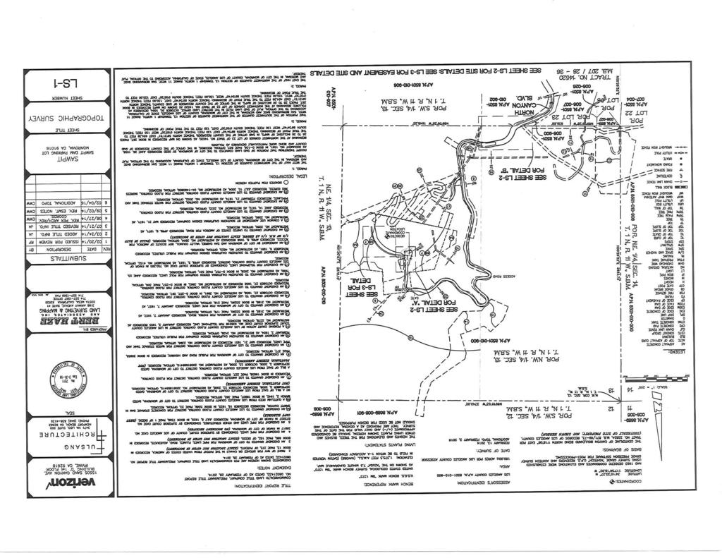
1 PLANNING COMMISSION STAFF REPORT APPLICATION: CUP /WFE /WFE / GPC AGENDA ITEM: PH-2 PREPARED BY: Barbara Lynch Senior Planner MEETING DATE: September 14, 2016 SUBJECT: REQUEST: APPLICANT: Conditional Use Permit CUP /Wireless Facilities Exception WFE (mono-pine/discouraged location)/wireless Facilities Exception WFE (exceeding maximum height)/general Plan Conformity GPC North Canyon Boulevard (Sawpit Dam) Erect an 80 tall wireless telecommunications facility (mono-pine) adjacent to the parking lot that serves the Sawpit Dam located in Canyon Park. A conditional use permit with an exception is requested to allow a wireless telecommunications facility to locate in the HR (Hillside Recreation) Zone that is defined as a Discouraged Location. Also, an exception is requested to exceed the maximum height limit of 45. A General Plan Conformity is needed to determine that the proposal conforms to the provisions of the General Plan. Verizon Wireless/Vinculums Services, Inc. 10 Pasteur, Suite 100 Irvine, CA ENVIRONMENTAL DETERMINATION: Categorical Exemptions (Class 3 and Class 11) BACKGROUND: In 2011 the Wireless Telecommunications Facilities Ordinance (MMC 17.46) was adopted to provide comprehensive regulations and permitting requirements regarding the installation of wireless telecommunication facilities on private property, public property and the City right-of-way. This application involves a location in Canyon Park (on City owned property) next to the Sawpit Dam parking lot. A conditional use permit with an exception is required because the Sawpit Dam is in a Discouraged Location for locating a wireless facility and a second exception is required to allow an 80 tall wireless facility in lieu of the maximum 45 height allowed by code. A General Plan Conformity determination is necessary to find that the project conforms with the provisions of the Monrovia General Plan. WIRELESS TELECOMMUNICATION FACILITIES LOCATION: Canyon Park is 80 acres of natural hillside area that has a nature center, a cabin conference facility, picnic areas, a waterfall and hiking trails. It is located at the northerly terminus of Canyon Boulevard. The Sawpit Dam is located off an access road within the park in an area that is away from the park improvements and adjacent residential properties.
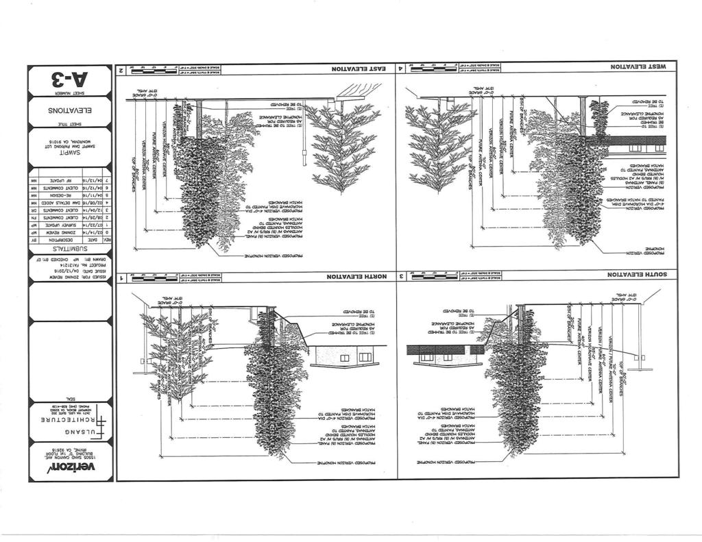
2 The Sawpit Dam location was owned by Los Angeles County Flood Control District (LACFCD) until 2003 when the property was transferred to the City. As part of this transfer ingress and egress easements were granted to LACFCD so that their facilities could be accessed. Also a condition of the land transfer requires that permission is obtained from LACFCD to construct improvements on the land. The Applicant received approval and a permit was first issued by LACFCD on February 23, However, LACFCD rescinded the permit and it was later amended and reissued on July 6, The permit was reissued after the Applicant changed the location of the cell tower from the center of the parking lot to outside of the parking lot. PROPOSED IMPROVEMENTS: The proposed wireless telecommunication improvements will include a mono-pine cell tower that will be installed near the easterly edge of the Sawpit Dam parking lot and an equipment enclosure that will be located approximately 150 away from the cell tower on the west side of the access road leading to the parking lot. The locations have been reviewed by City Staff and LACFCD personnel to insure that the improvements will not interfere with access to the dam facilities or to the dam-keepers facility (that is currently not occupied). It was determined that the proposed location would not interfere with larger commercial trucks and/or emergency vehicles. The 10 by 14 equipment enclosure will have 8 tall walls and will be constructed out of decorative block material. Two MCE equipment cabinets and a back-up generator will be inside the enclosure. The generator will only be used during power outages and testing will be limited to daytime hours if noise is audible to residential properties (DS1 #13). All cables between the cell tower and the equipment enclosure will be underground. There will be no overhead lines. The 80 tall mono-pine is designed to allow collocation with one other provider. Verizon s antennas will be approximately 70 above grade mounted on the pole and there will be a location 10 below the Verizon antennas for the other providers antennas. A new conditional use permit application will be required at the time a second wireless provider proposes to collocate on the cell tower. The Verizon pole mounted equipment includes eight antennas (8 long), eight RRU s (Remote Radio Unit s) mounted behind the antennas and one microwave dish (4 diameter). The location of the parking lot is higher in elevation than the park improvements and is surrounded with natural foliage and mature trees. The mono-pine will be provided with enough branches to screen the pole mounted equipment and blend with the nearby pine trees. The mature pine tree closest to the proposed mono-pine must be trimmed to provide the necessary clearances for such a cell tower. It is a very tight space between the edge of the parking lot and the toe of the slope where the mono-pine is to be installed. A certified arborist report that addresses the proposed tree trimming is required and is subject to the review and approval of the City s arborist to help ensure that the tree will survive. However, if the tree does not survive the Applicant will be required to pay the appraised replacement value that can be applied towards planting in other public areas (DS1 #12). DISCUSSION/ANALYSIS: The Wireless Telecommunications Facilities Ordinance sets forth regulations for wireless installations and defines locations that are preferred and discouraged. In general, preferred locations include all Commercial and Industrial zones (with the exception of the Historic Commercial Downtown (HCD) Zone) and discouraged locations include all Residential and Hillside zones (and the HCD Zone). The subject property is located in the Hillside Recreation (HR) Zone and is in a discouraged location.
3 Discouraged Location When a wireless telecommunications facility is proposed to be located in a discouraged location the applicant must provide information showing there is a significant gap in coverage in the area. A significant gap is defined the need to provide signal coverage or sufficient strength to achieve consistent, sustainable, and reliable service in an area where there is a current need. Verizon s radio frequency (RF) engineer has determined that there is a significant gap that covers approximately 8 to 10 square miles in this specific area. There is currently weak signal coverage causing limited capacity for wireless users. Propagation maps were submitted that show existing signal coverage and improved signal coverage with the installation of the proposed cell tower. Providing a cell tower near Sawpit Dam will provide improved coverage along North Canyon Boulevard and the Monrovia Canyon Truck Trail in Canyon Park. Other cell tower locations were evaluated in the area and due to the mountainous terrain it was determined that the other locations would require a second cell tower site to achieve the same coverage as the proposed single tower location. The proposed cell tower location will have existing paved access (via the service road) and will provide the coverage that is needed to provide reliable wireless coverage. Conditional Use Permit/Wireless Facilities Exceptions A conditional use permit with approval of an exception is required when a cell tower is proposed in a discouraged location. Height limits for cell towers in discouraged locations are restricted to 45 in comparison to 60 when a cell tower is in a preferred location. The exception request for the proposed 80 height is necessary to provide the coverage within the significant gap area and to be able to provide this from a single tower location. The proposed cell tower will be camouflaged as a mono-pine and is designed to allow a second provider on the tower. Due to the mature landscape and terrain this mono-pine should not be visible to any of the residential properties below Canyon Park. City Owned Property In addition to securing the approvals for the cell tower entitlements by the Planning Commission the Applicant must also enter into a lease agreement with the City because the improvements are on City owned property. The City Attorney has prepared a lease agreement that allows the cell tower to remain for 5 years and can be extended for 4 additional five year terms. The lease will be considered by City Council on September 20 th. In order to erect the cell tower at the subject site both the entitlements and the lease must be approved (DS1 #19). General Plan Conformity Pursuant to Section of the Government Code, the Planning Commission must make a finding that the proposed wireless facility improvements on city owned property conforms to the provisions of the City s General Plan. Staff recommends that the Planning Commission make this finding. The goals and objectives in the Safety Element were developed to protect citizens and property from major disasters (earthquakes, floods and fires). The property owners within the significant gap area as well as hikers, park visitors and emergency responders will be provided an improved level of security and safety with better wireless coverage that is currently not available in cases of emergency.
4 Conclusion The proposed wireless facility improvements are in a discouraged location where typically cell towers could have a negative impact on surrounding properties and uses. However, the subject location should have no impact as it will be hidden in the natural hillside terrain and landscape in an 80 acre park. It will not impact residential properties outside of the park, and the mono-pine design provides a camouflage that obscures it from view within the park. The cell tower will provide wireless coverage to an area that has little to no coverage and will provide a level of safety that is not currently available to people within the significant gap area. RECOMMENDATION: Staff recommends approval of the wireless telecommunication facility at in Canyon Park next to the Sawpit Dam. If the Planning Commission concurs with this recommendation then, following the public hearing, the adoption of the following resolution is appropriate: The Planning Commission of the City of Monrovia hereby finds, determines and resolves as follows: 1. Pursuant to the California Environmental Quality Act ( CEQA ) and the City s local CEQA Guidelines, the Planning Commission in the exercise of its independent judgment finds that CUP /WFE /WFE /GPC is categorically exempt from CEQA under Class 3 and Class The Planning Commission finds that the custodian of records for all other materials that constitute the record of proceeding upon which this decision is based is the Planning Division Manager. Those documents are available for public review in the Planning Division located at 415 South Ivy Avenue, Monrovia, California, The Planning Commission in the exercise of its independent judgment hereby makes the findings listed on attached Data Sheet No. 3 for CUP /WFE /WFE /GPC , which are incorporated herein by this reference. 4. The Planning Commission approves CUP /WFE /WFE /GPC , subject to the attached Planning Conditions on Data Sheet No. 1, Public Works Conditions on Data Sheet No. 2, and recommendations in the Staff Report, all of which are incorporated herein by this reference. MOTION: Close the public hearing and approve CUP /WFE /WFE /GPC subject to the attached Planning Conditions on Data Sheet No. 1, Public Works Conditions on Data Sheet No. 2, and recommendations in the Staff Report.
 in the vicinity of the Sawpit Dam in Canyon Park must remain in substantial conformance at all times with the request and application forms and plans for")
5 DATA SHEET 1 CUP /WFE /WFE /GPC Planning Conditions 1200 North Canyon Boulevard/ Sawpit Dam The installation of a Wireless Telecommunications Facility at 1200 North Canyon Boulevard (APN ) in the vicinity of the Sawpit Dam in Canyon Park must remain in substantial conformance at all times with the request and application forms and plans for CUP /WFE (Cell Tower/Discouraged Location) and WFE (Exceeding Maximum Height)/GPC General Plan Conformity submitted by Vinculums Services, Inc. as the agent representing Los Angeles SMSA Limited Partnership, a California limited partnership, dba Verizon Wireless (the wireless telecommunications facility owner and operator ), as approved by the Planning Commission and placed on file in the office of the Planning Division, except as modified by the conditions imposed by the Planning Commission and by subsequent modifications determined by the Planning Division Manager to be in substantial compliance with the conditions of approval. The term Applicant shall include, without limitation, the applicant, the wireless telecommunications facility owner and operator, the property owner (with the exception of the City as property owner), and all successors in interest to this conditional use permit. The terms wireless telecommunications facility or facility shall mean the Wireless Telecommunications Facility at 1200 North Canyon Boulevard (APN ) in the vicinity of the Sawpit Dam in Canyon Park. DEVELOPMENT STANDARDS 1. The Applicant shall submit as-built drawings within 90 days after installation of the facility. 2. All cables, including without limitation, electrical, transmission, communication, telephone, cable television, data, and utility cables (collectively, Utility Cables ), shall be run within the interior of the telecommunications tower and shall be camouflaged or hidden to the fullest extent feasible. Utility Cables to and from the development premises shall be placed underground. 3. In compliance with the Monrovia Municipal Code, the wireless telecommunications facility has been designed as a mono-pine, which is the approved concealment design to blend the pole, antennas, and related equipment within the surrounding forest-like area. All antenna components and accessory wireless equipment shall be treated with exterior coatings of a color and texture to visually blend in with the mono-pine. Sample(s) of the exterior coating(s) color and texture shall be submitted to the Planning Division Manager for review and approval prior to building permit issuance. Once approved, any change to the color or texture of such exterior coatings shall not be made unless applicant receives advanced written approval by the Planning Division Manager. -1-
6 4. The facility shall be properly engineered to withstand high wind loads. An evaluation of high wind load capacity shall include the impact of modification on the facility. 5. Equipment enclosure. The wireless telecommunications facility site shall be completely enclosed by an eight (8) foot high solid decorative masonry wall (with necessary gates constructed with approved screening materials). All storage of materials, equipment, equipment cabinets, and wireless telecommunications facility operation shall be completely screened from view, with the exception of those components that are expressly permitted to exceed the height of the required wall, such as the mono-pine. The wireless telecommunication facility shall not have any signs other than certification, warning or other signage required by law or expressly permitted in writing by the City. At all times, all required notices and signs shall be posted on the site as required by the Federal Communications Commission and California Public Utilities Commission, and as approved by the city. The location and dimensions of a sign bearing the emergency contact name and telephone number shall be posted pursuant to the approved plans. 6. The Applicant shall submit and maintain current at all times basic contact and site information on a form to be supplied by the Planning Division Manager. The Applicant shall notify the Planning Division Manager of any changes to the information submitted within seven days of any change, including change of the name or legal status of the owner or operator. This information shall include, but is not limited to, the following: a. Identity, including the name, address and 24-hour local or toll free contact phone number of the Applicant, the owner, the operator, and the agent or person responsible for the maintenance of the facility. b. The legal status of the owner of the wireless telecommunications facility, including official identification numbers and Federal Communications Commission certification. c. Name, address and telephone number of the property owner if different than the Applicant. 7. Upon any transfer or assignment of the permit, the Director of Community Development may require submission of any supporting materials or documentation necessary to determine that the proposed use is in compliance with the existing permit and all of its conditions of approval including, but not limited to, statements, photographs, plans, drawings, models, and analysis by a state-licensed radio frequency engineer demonstrating compliance with all applicable regulations and standards of the Federal Telecommunications Commission and the California Public Utilities Commission. If the Director determines that the proposed operation is not consistent with the existing permit, the Director shall notify the Applicant who shall either revise the application or apply for modification of the permit pursuant to the requirements of the Monrovia Municipal Code. -2-
7 8. The Applicant shall not place any facilities that will deny access to, or otherwise interfere with, any public utility, easement, or right-of-way located on the site without written permission from the applicable owner or easement holder. The Applicant shall allow the city reasonable access to, and maintenance of, all utilities and existing public improvements within or adjacent to the site, including, but not limited to, pavement, trees, public utilities, lighting and public signage. Prior to the issuance of building permits, Applicant shall obtain all permits, permissions, leases, licenses, and easement agreements required by any other governmental entity or property owner for the site, including without limitation, the County of Los Angeles Department of Public Works. A copy of such permits, permissions, leases, licenses, and easement agreements shall be delivered to the Planning Division prior to issuance of building permits. 9. At all times, the wireless telecommunications facility must comply with the most current regulatory and operational standards including, but not limited to, radio frequency emissions standards adopted by the Federal Communications Commission and antenna height standards adopted by the Federal Aviation Administration. 10. If the Director of Community Development determines there is good cause to believe that the facility may emit radio frequency emissions that are likely to exceed Federal Communications Commission standards, the Director may require the Applicant to submit a technically sufficient written report certified by a qualified radio frequency emissions engineer, certifying that the facility is in compliance with such FCC standards. 11. An arborist report that addresses the trimming and long term maintenance of the pine tree adjacent to the mono-pine shall be submitted for review and approval by the Public Works Division Manager. If at any time the pine tree requires removal while the mono-pine is at the subject location, the City s arborist shall review and make the determination that the removal is necessary. If at any time the tree is damaged while the wireless improvements are in place or being removed, the City s arborist shall review and make the determination if the tree will survive. If the City s arborist determines that the extent of damage will eventually kill the tree or if the tree has to be removed, prior to approved removal an appraised replacement value of $10,000 shall be paid to the City s Parks Division of the Public Services Department to use for planting low water use trees and/low water use landscaping in public areas of the City. The Applicant shall also be responsible for the removal of the tree. 12. The Applicant shall pay for and provide a performance bond in the amount of $75,000, which shall be in effect until the wireless telecommunication facility is removed and the site is reasonably returned to its original condition. The bond coverage shall include without limitation removal of the facility and maintenance obligations. Such performance bond shall be in a form satisfactory to the City Attorney and Risk Manager, naming City as obligee. 13. Noise. Applicant s wireless telecommunications facility shall be operated in such a manner so as to minimize any possible disruption caused by noise. The backup generator at the site shall only be operated during periods of power -3-
8 outages, and shall not be tested on weekends or holidays, or between the hours of 7:00 PM and 7:00 AM if the noise level is audible to residential properties. 14. Plans showing all exterior lighting shall be submitted to the Planning Division for review prior to building permit issuance and no exterior lighting shall be installed without the approval of the Planning Division Manager. All exterior lighting shall be designed, arranged, and installed so as to confine direct rays onto the premises and to direct light away from adjacent structures and wilderness. No automatic lights (timer or other automated trigger) shall be allowed. Lights shall only be illuminated when workers are present and working on the premises. 15. If a nearby property owner registers a noise complaint and such complaint is verified as valid by the Police Department, Code Enforcement, or other City department, the City may hire a consultant to study, examine and evaluate the noise complaint and the Applicant shall pay the fee for the consultant. The matter shall be reviewed by the Development Review Committee (DRC). If the DRC determines sound proofing or other sound attenuation measures should be required to bring the project into compliance with the code (MMC (M)), the DRC may impose that condition on the project after notice and a public hearing. 16. At the discretion of the Planning Division Manager, the Applicant may be required by the City to repaint or otherwise re-color the antennas, supporting structure and any portions of the wireless facility visible from any public place, so as to match the original color(s), and to replace or repair any stealthing material that is missing, discolored, or otherwise in poor maintenance to its original quantity and quality. 17. Notwithstanding Condition No. 15, all facility components, including, but not limited to, telecommunication towers, poles, accessory equipment, lighting, fences, walls, shields, cabinets, artificial foliage or camouflage, and the facility site shall be maintained in good condition, including ensuring the facilities are reasonably free of: a. General dirt and grease; b. Chipped, faded, peeling, and cracked paint; c. Rust and corrosion; d. Cracks, dents, and discoloration; e. Missing, discolored or damaged artificial foliage or other camouflage; f. Graffiti, bills, stickers, advertisements, litter and debris; g. Broken and misshapen structural parts; and h. Any damage from any cause. -4-
9 18. The Applicant shall replace its facility, or part thereof, after obtaining all required permits, if maintenance or repair is not sufficient to return the facility to the condition it was in at the time of installation. The Applicant shall routinely inspect the facility and site to ensure compliance with the standards set forth in the Monrovia Municipal Code and these conditions of approval. 19. The City owns certain real property, and Applicant proposes to develop and install the wireless telecommunications facility pursuant to this conditional use permit on a portion the real property owned by the City (the site ). At the time this conditional use permit was granted, the City in its proprietary capacity as property owner, and the wireless telecommunications facility owner and operator, were negotiating a ground lease and related easements for Applicant s occupation, development and use of the site (the Ground Lease for the Installation and Use of the Wireless Telecommunications Facility at Sawpit Dam ). This conditional use permit does not substitute for such lease agreement, which must be approved by City Council and executed by both parties (Applicant and City), and a fully executed copy delivered to the Planning Division, prior to any development or occupation of the site by Applicant and prior to the issuance of any building permits. 20. In the event Applicant desires to modify the facility, Applicant shall apply for and obtain all permits or permit amendments required by the Monrovia Municipal Code, prior to making any modification to the facility. At a minimum, any application for modification to the facility shall use the concealment design approved by this permit including without limitation, blending, stealthing, screening, and camouflaging, unless a more effective concealment design is proposed by the Applicant or required by the Monrovia Municipal Code, or the pole is redesigned or replaced such that it necessitates a new concealment design that is consistent with the redesigned or replaced pole. Additionally, to the extent feasible, when the facility is modified existing equipment shall be replaced with equipment that reduces visual, noise and other impacts, including, but not limited to, undergrounding the equipment and replacing larger, more visually intrusive facilities with smaller, less visually intrusive facilities. Under the Monrovia Wireless Telecommunications Facilities Ordinance, Modification means a change to an existing wireless telecommunications facility that involves any of the following: collocation, expansion, alteration, enlargement, intensification, reduction, or augmentation, including, but not limited to, changes in size, shape, color, visual design, or exterior material. Modification does not include repair, replacement or maintenance if those actions do not involve a change to the existing facility involving any of the following: collocation, expansion, alteration, enlargement, intensification, reduction, or augmentation. 21. In the event the facility ceases to provide wireless telecommunications services for ninety (90) or more consecutive days, the facility shall be considered abandoned and shall be promptly removed as provided in these conditions of approval and the Monrovia Municipal Code. If there are two (2) or more users of a single facility, then this provision shall not become effective until all users cease using the facility. -5-
10 22. Applicant shall notify the City in writing of its intent to abandon or cease use of the facility within ten (10) days of ceasing or abandoning use. Additionally, the Applicant shall provide written notice to the Director of Community Development of any discontinuation of operations of thirty (30) days or more. 23. Failure to inform the Director of Community Development of cessation or discontinuation of operations of the facility as required by these conditions of approval shall constitute a violation of the conditions of approval and be grounds for: a. Prosecution; b. Revocation or modification of the permit; c. Calling of any bond or other assurance required by the Monrovia Municipal Code or conditions of approval of the permit; d. Removal of the facility by the City in accordance with the procedures established under the Monrovia Municipal Code for abatement of a public nuisance at the Applicant s expense; and/or e. Any other remedies permitted under the Monrovia Municipal Code. 24. Upon the expiration date of the permit, including any extensions, earlier termination or revocation of the permit or abandonment of the facility, the Applicant shall remove the facility and restore the site to its natural condition except for retaining the landscaping improvements and any other improvements at the discretion of the City. Removal shall be in accordance with proper health and safety requirements and all ordinances, rules, and regulations of the City. The facility shall be removed from the property, at no cost or expense to the City. 25. Failure of the Applicant to promptly remove the facility and restore the property within thirty (30) days after expiration of this permit, earlier termination or revocation of this permit, or abandonment of the facility, shall be a violation of the Monrovia Municipal Code, and shall be grounds for: a. Prosecution; b. Calling of any bond or other assurance required by the Monrovia Municipal Code or conditions of approval of permit; c. Removal of the facility by the City in accordance with the procedures established under the Monrovia Municipal Code for abatement of a public nuisance at the Applicant s expense; and/or d. Any other remedies permitted under the Monrovia Municipal Code. CONSTRUCTION SITE REQUIREMENTS 26. Applicant shall provide temporary perimeter fencing with view obscuring material during construction. If graffiti is painted or marked in any way upon the premises -6-
11 or on an adjacent area under the control of the Applicant (including without limitation, any temporary perimeter construction fencing or permanent wall), the graffiti shall be removed or painted over by Applicant within twenty-four hours, unless any law in effect at that time imposes a shorter time period for eradication. 27. One waterproof sign (36 x 48 ) in both English and Spanish noting construction hours and a phone number for contact shall be posted by the Applicant at the front of the site prior to grading or construction. GENERAL REQUIREMENTS 28. The Applicant shall defend, indemnify, protect and hold harmless the City, its elected and appointed Council members, boards, commissions, officers, officials, agents, consultants, employees, and volunteers from and against any and all claims, actions, or proceeding against City, its elected and appointed Council members, boards, commissions, officers, officials, agents, consultants, employees and volunteers to attack, set aside, void or annul, an approval of the City, Planning Commission or City Council concerning this permit and the project. Such indemnification shall include damages, judgments, settlements, penalties, fines, defensive costs or expenses, including, but not limited to, interest, attorneys fees and expert witness fees, or liability of any kind related to or arising from such claim, action, or proceeding. The City shall promptly notify the Applicant of any claim, action, or proceeding. Nothing contained herein shall prohibit city from participating in a defense of any claim, action or proceeding. The City shall have the option of coordinating the defense, including, but not limited to, choosing counsel for the defense at Applicant s expense. 29. The facility shall at all time comply with any and all applicable local, state, and federal laws, regulations and guidelines. Any violation of these conditions of approval or the Monrovia Municipal Code may be subject to the Administrative Fine Ordinance, other available remedies and/or revocation or modification of this permit at the discretion of the City Attorney and City Prosecutor. 30. This conditional use permit may be called for review, including modification or revocation, at any time by City Staff, the City Council, or Planning Commission if a violation of the approved conditions or the Monrovia Municipal Code (MMC) is alleged, or if it is alleged that the facility is creating a public nuisance, and such violation or public nuisance is verified as valid by the Police Department, Code Enforcement, or other City department. 31. In addition to Planning (Data Sheet No. 1) and Public Works (Data Sheet No. 2) conditions of approval, the Applicant shall also comply with all requirements of the Monrovia Municipal Code, Building Division and Fire Department that are directly applicable to the project. 32. The Applicant shall, within 30 days after approval by the Planning Commission, submit to the Community Development Department his/her written consent to all of the conditions of approval contained in Data Sheet Numbers 1 and 2. CUP /WFE /WFE and GPC shall be void and of -7-
12 no force or effect unless such written consent is submitted to the City within the 30 day period. 33. The use or development associated with CUP /WFE /WFE and GPC shall begin within one (1) year after its approval or it will expire without further action by the City. 34. The Applicant shall maintain a current City business license at all times. 35. All of the above conditions shall be complied with prior to commencement of the operation, unless an earlier compliance period is specified as part of a condition. -8-
13 DATA SHEET 2 CUP /WFE /WFE /GPC Public Works Conditions 1200 North Canyon Boulevard/ Sawpit Dam The installation of a Wireless Telecommunications Facility at 1200 North Canyon Boulevard (APN ) in the vicinity of the Sawpit Dam in Canyon Park shall also be subject to the public works conditions of approval listed below, and if so indicated, the condition(s) shall be satisfied prior to the issuance of a certificate of occupancy/final inspection for the project, unless an earlier or later compliance period is specified as part of a condition. The term Applicant shall include, without limitation, the applicant, the wireless telecommunications facility owner and operator, the property owner (with the exception of the City as property owner), and all successors in interest to this conditional use permit. The application for this project was submitted by Vinculums Services, Inc. as the agent representing Los Angeles SMSA Limited Partnership, a California limited partnership, dba Verizon Wireless (the wireless telecommunications facility owner and operator ). Engineering Conditions 1. Prior to any development, the Applicant shall submit Plans, Details, Proof of Rights-of -Way, Easements, existing site plan, topographic map of the project site, utility extensions and connections, specifications for all Civil Engineering work to be done on-site and off-site, to the Engineering Division of the Public Services Department for review and approval prior to any encroachment permit being issued to the applicant. The plans shall indicate existing and proposed features, structure foundations, retaining walls and miscellaneous facilities if applicable and all utilities applicable to and within the project site. The plans shall be prepared on a maximum 24 x 36 sheets with City standard title block stamped and signed by a Registered Professional Civil Engineer in the State of California. The submittal of the plans shall include: required design calculations, a cost estimate, a plan check fee, and an inspection fee. The final submittal for final approval shall include a mylar of the approved plan. The applicant shall use the assigned drawing number obtained from engineering for this project. Partial or incomplete submittals will not be accepted. 2. All plans submitted by the Applicant, including but not limited to site plans, utility plans and street improvement plans, shall be coordinated for consistency and shall be approved by the City Engineer prior to the issuance of any construction permit. Applicant shall pay all fees for Engineering Division services such as plan check fee and construction inspection fee, and obtain an encroachment permit for all work within the City right-of-ways.. 3. The Applicant shall provide a current title report or right entry by council approved and recorded utility easement for the project site located in the City of Monrovia. The title report, or right of entry is required and such documents shall show all fee interest holders; all interest holders whose interest could ripen into
14 a fee; all trust deeds, together with the name of the trustee; and all easement holders, and any legal access documents that could conflict with this development. 4. The City requires the restoration of the existing pavement after utility installation, if the pavement is disturbed during construction. Restoration is required from the outer limits of the area covering and encompassing all the utility cuts as shown on the plans, but actual limits shall be determined out in the field by City Engineer. Restoration of asphalt pavement may be up to 2-inch pavement grind and 2-inch asphalt overlay, removal and replacement of broken AC or PCC pavement, cape seal, and slurry seal Type II, or combination of any of the method of pavement restoration as directed by the City Engineer. The scope of work shall be mutually agreed by the City Engineer and the Applicant prior to approval of any construction plans and/or issuance of any Public Works permits. 5. Prior to start of any construction activity, Applicant shall provide a Transportation Plan to the Public Works Department formalizing the approved truck route to and from the site though the City of Monrovia streets. Transportation plan will address allowable times for trucks and construction vehicles for access to the site. No construction activity will be allowed without first getting approval of all required submittals to the Engineering Division. 6. The Applicant shall repair, at its sole cost and expense, any damage including, but not limited to subsidence, cracking, erosion, collapse, weakening, or loss of lateral support to City streets, sidewalks, walks, curbs gutters, trees, parkways, street lights, traffic signals, improvements of any kind or nature, or utility lines and systems, underground utility line and systems, or sewer systems and sewer lines that result from any activities performed in connection with the installation and/or maintenance of a wireless telecommunications facility on City property. The Applicant shall restore such areas, structures and systems to the condition in which they existed prior to the installation or maintenance that necessitated the repairs. In the event the applicant fails to complete such repair, all future upgrades and additions to this system will be conditioned with these reconstructions and shall be completed prior to any additional approvals.
15 DATA SHEET 3 CUP /WFE /WFE /GPC Findings 1200 North Canyon Boulevard/ Sawpit Wash CONDITIONAL USE PERMIT ( ) As required by Section of the Monrovia Municipal Code (MMC), the decision for granting CUP , WFE and WFE to allow a wireless telecommunications facility located in the vicinity of Sawpit Dam in Canyon Park is based on the following findings: A. The project site is adequate in size, shape and topography for the proposed wireless facility location. The topography of this hillside area is mountainous and is improved with an access road and level parking lot area that is adequate in size to accommodate a cell tower and an equipment enclosure. B. The project site has sufficient access to streets and highways, adequate in width and pavement type to carry the quantity and quality of traffic generated by the wireless facility. The proposed use will not generate traffic other than commercial vehicles that will periodically be used for maintenance of the site. The existing service road and access from Canyon Boulevard is adequate to support this vehicle activity and traffic loads. C. The proposed wireless facility is compatible with the General Plan and will not adversely impact the objectives of the General Plan. The wireless facility is in a discouraged location and an exception is requested to accommodate the proposed facility. The conditional use permit is being approved because the Applicant has submitted documentation that demonstrates that there is an existing significant gap in coverage in this area of the City; there is little to no wireless coverage currently available in an 8 to 10 square mile area. The proposed location is the least intrusive location to provide a wireless facility that closes the significant gap in coverage, because it is a sufficient distance from residences within the City and is designed to blend into its surroundings. Accordingly, this project is consistent with the General Plan. D. The proposed wireless facility in Canyon Park will comply with the applicable provisions of the zoning ordinance except for locating in a discouraged location and exceeding the height limit. The Applicant has submitted documentation that demonstrates that these two exception requests are necessary to construct a wireless communication facility that will close a significant gap in coverage, which will improve wireless coverage and enhance public safety in this area. In addition, the proposed location is the least intrusive location to provide a wireless facility that closes the significant gap in coverage, because it is a sufficient distance from residences within the City and is designed to blend into its surroundings. E. The location of the wireless facility and the conditions under which it will be operated or maintained will not be detrimental to the public health, safety or welfare, nor will it 1 of 3
16 be materially injurious to properties or improvements in the vicinity. The facility is located in an area that is a sufficient distance from residential uses and is designed to blend in with its surroundings. In addition, the Applicant will comply with the conditions of approval for the wireless facility to ensure that the mono-pine is maintained to provide the necessary camouflage, and the generator will be operated in a manner that will not be detrimental or injurious to the public and surrounding uses. CONDITIONAL USE PERMIT ( ) As required by Section of the Monrovia Municipal Code (MMC), the decision for granting CUP , WFE and WFE to allow a wireless telecommunications facility located in the vicinity of Sawpit Dam in Canyon Park is also based on the following findings: A. The proposed facility has been designed and located in compliance with all applicable provisions of the City s Wireless Telecommunications Facilities ordinance. The Applicant submitted documentation that demonstrated the existence of a significant gap in coverage, which justifies the exceptions to locate the facility in a discourage location and to exceed the height limits specified in the Municipal Code. The cell tower will be camouflaged and will be located on a site that is sufficient distance away from residential properties and uses that otherwise could be negatively impacted. B. The proposed facility has been designed and located to achieve compatibility with the community to the maximum extent reasonably feasible. The site does not require excavation for an access road as one already exists and the location is obscured from view with large mature trees and a mountainous terrain. It is located away from park facilities and residential homes. C. The applicant has submitted a statement of its willingness to allow other carriers to collocate on the proposed wireless telecommunications facility wherever technically and economically feasible and where collocation would not harm community compatibility. The wireless facility has been designed to allow one other provider to collocate on the facility, and the requirement for co-location is specified in the lease agreement between the City and the applicant. D. Noise generated by equipment will not be excessive, annoying nor be detrimental to the public health, safety, and welfare and will not exceed the standards set forth in the Wireless Telecommunications Facilities ordinance. The wireless facility is located in an 80 acre park away from residential properties. The back-up generator should not be audible to properties outside of the park; however if it is found that residential properties are adversely impacted a condition of approval restricts generator testing to daytime hours. 2 of 3
17 EXCEPTIONS ( ) As required by Section of the Monrovia Municipal Code (MMC), the decision for granting CUP , WFE and WFE an exception to allow a wireless telecommunications facility located in the vicinity of Sawpit Dam in Canyon Park is based on the following findings: A. Denial of the facility as proposed would violate state and/or federal law. The exceptions requested for locating a wireless facility in a discouraged location and exceeding the height limit is necessary to close a significant gap in coverage. The applicant has provided propagation maps and a report from an RF engineer that documents and confirms that there currently is a significant gap in coverage that needs to be addressed, as required by state and federal law. B. The provisions of the Wireless Telecommunications Facilities ordinance, as applied to applicant, would deprive applicant of its rights under state and/or federal law. The applicant has provided propagation maps and a report from an RF engineer that documents and confirms that there currently is a significant gap in coverage in an 8 to 10 square mile area where service currently is weak and/or not available. The proposed improvements are designed to camouflage the wireless facility and are environmentally sensitive to the natural hillside area. 3 of 3
18
19
20
21
22
23
24
25
MODEL WIRELESS TELECOMMUNICATIONS ORDINANCE for Siting of "Small Cell" Telecommunication Infrastructure in Public Rights-Of-Way
 MODEL WIRELESS TELECOMMUNICATIONS ORDINANCE for Siting of "Small Cell" Telecommunication Infrastructure in Public Rights-Of-Way This document is intended for use by towns and villages that have existing
RESOLUTION PC NOW THEREFORE, the Planning Commission of the City of Duarte resolves as follows:
 RESOLUTION PC 18-09 A RESOLUTION OF THE PLANNING COMMISSION OF THE CITY OF DUARTE APPROVING CONDITIONAL USE PERMIT 14-02, FOR THE USE AND OPERATION OF A WIRELESS COMMUNICATION FACILITY FOR VERIZON WIRELESS,
MONTEREY COUNTY PLANNING COMMISSION
 MONTEREY COUNTY PLANNING COMMISSION Meeting: June 11, 2003 @ 9:30 AM Agenda Item: D2 Project Description: Use Permit (Associated Tagline/Sprint #PLN000669) for the construction of a 50 Ft. monopole with
ARTICLE VI. SPECIAL EXCEPTION REGULATIONS
 ARTICLE VI. SPECIAL EXCEPTION REGULATIONS SECTION 601. GENERAL DESCRIPTION Special exceptions are deemed to be permitted uses in their respective districts, subject to the satisfaction of the requirements
PLANNING COMMISSION STAFF REPORT
 PLANNING COMMISSION STAFF REPORT APPLICATION: CUP2017-09 AGENDA ITEM: PH-1 PREPARED BY: Austin Arnold Planning Technician MEETING DATE: October 11, 2017 SUBJECT: REQUEST: APPLICANT: Conditional Use Permit
City of San Juan Capistrano Supplemental Agenda Report
 City of San Juan Capistrano Supplemental Agenda Report TO: FROM: DATE: SUBJECT: Planning Commission Development Services Department... / Submitted by: Charles View, Development Services Dire ct~.. J,J._
ZONING ADMINISTRATOR AGENDA
 COMMUNITY DEVELOPMENT SERVICES PLANNING SERVICES ZONING ADMINISTRATOR AGENDA July 8, 2015 CITY HALL, COUNCIL CHAMBERS 3:00 PM 1. 1455 Veterans Boulevard (Redwood Trading Post) Use Permit application (UP2015-08)
SANTA BARBARA COUNTY ZONING ADMINISTRATOR STAFF REPORT August 30, 2007
 SANTA BARBARA COUNTY ZONING ADMINISTRATOR STAFF REPORT August 30, 2007 PROJECT: Detrana Entry Gates HEARING DATE: October 22, 2007 STAFF/PHONE: Sarah Clark, (805) 568-2059 GENERAL INFORMATION Case No.:
ARTICLE II: CELLULAR ANTENNA TOWERS
 Kenton County Planning Commission 8 ARTICLE II: CELLULAR ANTENNA TOWERS SECTION 2.0 PRE-APPLICATION CONFERENCE: Applicants must contact Staff and request a pre-application conference. This meeting will
TEMPORARY USE APPLICATION Sec and Temporary Housing
 Temporary Use Application Page 1 of 6 Receipt Date Stamp CITY OF CARLSBAD Planning, Engineering, and Regulation Department PO Box 1569, Carlsbad, NM 88221 Phone (575) 885-1185 Fax (575) 628-8379 TEMPORARY
TITLE 33 REGULATION OF WIRELESS TELECOMMUNICATIONS FACILITIES
 CITY OF STURGIS ORDINANCES TITLE 33-1 TITLE 33 REGULATION OF WIRELESS TELECOMMUNICATIONS FACILITIES (Title 33 established effective 8/4/07, Ordinance 2007-17) Chapters: 33.01: General Provisions 33.02:
City of Huntington Beach Community Development Department STAFF REPORT
 City of Huntington Beach Community Development Department STAFF REPORT TO: Planning Commission FROM: Scott Hess, AICP, Director of Community Development BY: Jessica Bui, Assistant Planner DATE: June 28,
RESOLUTION NO. PC 18-14
 RESOLUTION NO. PC 18-14 A RESOLUTION OF THE PLANNING COMMISSION OF THE CITY OF DUARTE APPROVING CONDITIONAL USE PERMIT 18-02, FOR THE USE AND OPERATION OF AN INDOOR PLAY SPACE, LOCATED AT 1040 HUNTINGTON
ARTICLE XX THE COUNTY BOARD OF MERCER COUNTY, ILLINOIS RESOLUTION AMENDING THE MERCER COUNTY ZONING ORDINANCE SOLAR ENERGY FACILITIES
 ARTICLE XX THE COUNTY BOARD OF MERCER COUNTY, ILLINOIS RESOLUTION AMENDING THE MERCER COUNTY ZONING ORDINANCE SOLAR ENERGY FACILITIES 20.1 TITLE. This ordinance shall be known as the Solar Energy Ordinance.
EXHIBIT F RESOLUTION NO.
 RESOLUTION NO. A RESOLUTION OF THE PLANNING BOARD OF THE CITY OF BURBANK TO APPROVE PROJECT NO. 17-0001385 FOR A CONDITIONAL USE PERMIT AMENDMENT AND AMENDING PROJECT NUMBER 2005-112 APPROVED UNDER RESOLUTION
Community Development Department Planning Division 1600 First Street + P.O. Box 660 Napa, CA (707)
") Community Development Department Planning Division 1600 First Street + P.O. Box 660 Napa, CA 94559-0660 (707) 257-9530 PLANNING COMMISSION STAFF REPORT MARCH 3, 2016 AGENDA ITEM # 7.B. File No. 15-0158
Community Development Department Planning Division 1600 First Street + P.O. Box 660 Napa, CA 94559-0660 (707) 257-9530 PLANNING COMMISSION STAFF REPORT MARCH 3, 2016 AGENDA ITEM # 7.B. File No. 15-0158
CHAPTER 154 RIGHTS OF WAY
 CHAPTER 154 RIGHTS OF WAY 154.01 Purpose and Rule of Interpretation 154.09 City Construction and Paving 154.02 Franchise, License or Lease Required 154.10 Design Notice to City 154.03 Fees Required 154.11
PROPOSED ORDINANCE NO TOWNSHIP OF WHITEMARSH MONTGOMERY COUNTY, PENNSYLVANIA ORDINANCE NO.
 PROPOSED ORDINANCE NO. 2014-16 TOWNSHIP OF WHITEMARSH MONTGOMERY COUNTY, PENNSYLVANIA ORDINANCE NO. AN ORDINANCE OF THE TOWNSHIP OF WHITEMARSH, MONTGOMERY COUNTY, PENNSYLVANIA; PROVIDING FOR THE AMENDMENT
PC RESOLUTION NO. 15~11-10~01 CONDITIONAL USE PERMIT (CUP)
") PC RESOLUTION NO. 15~11-10~01 CONDITIONAL USE PERMIT (CUP) 15-005 A RESOLUTION OF THE PLANNING COMMISSION OF THE CITY OF SAN JUAN CAPISTRANO, CALIFORNIA APPROVING A MUSIC EDUCATION FACILITY IN EXISTING
PC RESOLUTION NO. 15~11-10~01 CONDITIONAL USE PERMIT (CUP) 15-005 A RESOLUTION OF THE PLANNING COMMISSION OF THE CITY OF SAN JUAN CAPISTRANO, CALIFORNIA APPROVING A MUSIC EDUCATION FACILITY IN EXISTING
A PUBLIC RIGHT-OF-WAY MANAGEMENT ORDINANCE BY THE CITY OF SOUTHLAKE, TEXAS; REGULATING THE PHYSICAL USE, OCCUPANCY AND MAINTENANCE
 ORDINANCE NO. 1178 A PUBLIC RIGHT-OF-WAY MANAGEMENT ORDINANCE BY THE CITY OF SOUTHLAKE, TEXAS; REGULATING THE PHYSICAL USE, OCCUPANCY AND MAINTENANCE OF CITY RIGHTS-OF-WAY BY WIRELESS NETWORK PROVIDERS;
TYPE II LAND USE APPLICATION Telecommunications Tower: Collocation
 LAND MANAGEMENT DIVISION Date Received: TYPE II LAND USE APPLICATION Telecommunications Tower: Collocation PUBLIC WORKS DEPARTMENT 3050 N. DELTA HWY, EUGENE OR 97408 Planning: 682-3577 For Office Use Only
This project is categorically exempt from the requirements of CEQA under Categorical Exemption, Section Existing Facilities.
 WALNUT CREEK PLANNING COMMISSION RESOLUTION NO. > CONDITIONAL USE PERMIT (TREE REMOVAL PERMIT) APPLICATION NO. Y14-133 2055 N. BROADWAY OFFICE EXTERIOR REMODEL 2055 N. Broadway, APN: 173-141-039 (EFFECTIVE
Check all that apply: Major Facility Major Modification Collocation Substantial Change
 Community Development Department 14000 City Center Dr., Chino Hills, CA 91709 (909) 364-2780 Fax (909) 364-2795 www.chinohills.org CUP No.: TDA No.: Submittal Date: CONDITIONAL USE PERMIT FOR WIRELESS
EL DORADO COUNTY PLANNING AND BUILDING DEPARTMENT ZONING ADMINISTRATOR STAFF REPORT VARIANCE
 EL DORADO COUNTY PLANNING AND BUILDING DEPARTMENT ZONING ADMINISTRATOR STAFF REPORT Agenda of: April 18,2018 Item No.: Staff: 5.a. Emma Carrico VARIANCE FILE NUMBER: APPLICANT: REQUEST: LOCATION: V17-0003/La
PA Conditional Use Permit for Kumon Learning Center at 1027 San Pablo Ave.
 TO: FROM: SUBJECT: ALBANY PLANNING & ZONING COMMISSION ANNE HERSCH, AICP, CITY PLANNER PA 15-001Conditional Use Permit for Kumon Learning Center at 1027 San Pablo Ave. DATE: January 28, 2015 Property Owner
AN ORDINANCE TO REGULATE THE INSTALLATION OF COMMUNICATION ANTENNA(S) WITHIN THE PUBLIC-RIGHT-OF-WAY
 WITHIN THE PUBLIC-RIGHT-OF-WAY") TOWNSHIP OF FAIRFIELD ORDINANCE #2018-02 AN ORDINANCE TO REGULATE THE INSTALLATION OF COMMUNICATION ANTENNA(S) WITHIN THE PUBLIC-RIGHT-OF-WAY WHEREAS, the Mayor and Council ofthe Township of Fairfield
TOWNSHIP OF FAIRFIELD ORDINANCE #2018-02 AN ORDINANCE TO REGULATE THE INSTALLATION OF COMMUNICATION ANTENNA(S) WITHIN THE PUBLIC-RIGHT-OF-WAY WHEREAS, the Mayor and Council ofthe Township of Fairfield
A G E N D A CITY OF BUENA PARK ZONING ADMINISTRATOR
 A G E N D A CITY OF BUENA PARK ZONING ADMINISTRATOR September 2, 2016 COMMUNITY DEVELOPMENT CONFERENCE ROOM 10:00 a.m. Members of the public who wish to discuss an item should fill out a speaker identification
SHIAWASSEE COUNTY ZONING ORDINANCE Article 4 Specific Use Regulations
 SHIAWASSEE COUNTY ZONING ORDINANCE Article 4 Specific Use Regulations Section 4.3.76 Wind Energy Conversion Systems 1. Purpose A. Through this section it is hereby set forth that Shiawassee County promotes
CABLE TELEVISION FRANCHISE AND REGULATIONS
 113.01 Definitions 113.09 Service Rules 113.02 Grant of Authority 113.10 Franchise Fee 113.03 Franchise Term 113.11 Use of Streets and Property 113.04 Franchise Territory 113.12 Indemnification and Insurance
Sagamore Hills Township Valley View Rd. Sagamore Hills, OH (330) Phone (330) Fax
 Phone (330) Fax") Right-of-Way Excavation Rules & Regulations 1. PERMIT REQUIRED: A right-of-way excavation permit is required when placing, extending, or repairing any pipes, cables, wires, roadway structure or appurtenances,
Right-of-Way Excavation Rules & Regulations 1. PERMIT REQUIRED: A right-of-way excavation permit is required when placing, extending, or repairing any pipes, cables, wires, roadway structure or appurtenances,
Division 16.Telecommunication Tower Standards
 Division 16.Telecommunication Tower Standards Section 17-311. Telecommunication towers and antennas: general provision. The Director shall have the authority to regulate the construction and operation
A G E N D A CITY OF BUENA PARK ZONING ADMINISTRATOR
 A G E N D A CITY OF BUENA PARK ZONING ADMINISTRATOR December 13, 2017 COMMUNITY DEVELOPMENT CONFERENCE ROOM 3:00 p.m. Members of the public who wish to discuss an item should fill out a speaker identification
Community Development Department Planning Division 1600 First Street + P.O. Box 660 Napa, CA (707)
") Community Development Department Planning Division 1600 First Street + P.O. Box 660 Napa, CA 94559-0660 (707) 257-9530 PLANNING COMMISSION STAFF REPORT July 7, 2016 AGENDA ITEM #6.C. PL16-0038 HEXA PERSONAL
Community Development Department Planning Division 1600 First Street + P.O. Box 660 Napa, CA 94559-0660 (707) 257-9530 PLANNING COMMISSION STAFF REPORT July 7, 2016 AGENDA ITEM #6.C. PL16-0038 HEXA PERSONAL
CITY OF ESCONDIDO Planning Division 201 North Broadway Escondido, CA (760) Fax: (760)
 Fax: (760)") CITY OF ESCONDIDO Planning Division 201 North Broadway Escondido, CA 92025-2798 (760) 839-4671 Fax: (760) 839-4313 SECOND DWELLING UNIT PERMIT FOR INTERNAL USE ONLY Case No: Date Submitted: Fees Submitted:
CITY OF ESCONDIDO Planning Division 201 North Broadway Escondido, CA 92025-2798 (760) 839-4671 Fax: (760) 839-4313 SECOND DWELLING UNIT PERMIT FOR INTERNAL USE ONLY Case No: Date Submitted: Fees Submitted:
1.0 REQUEST. SANTA BARBARA COUNTY ZONING ADMINISTRATOR Coastal Zone Staff Report for Vincent New Single-Family Dwelling & Septic System
 SANTA BARBARA COUNTY ZONING ADMINISTRATOR Coastal Zone Staff Report for Vincent New Single-Family Dwelling & Septic System Hearing Date: February 26, 2007 Supervisorial District: First Staff Report Date:
Planning and Zoning Staff Report Maverick Towers Van Wassenhove, PH
 Planning and Zoning Staff Report Maverick Towers Van Wassenhove, PH2018-17 Hearing Date: April 19, 2018 Development Services Department Applicant: Maverick Towers - Nadine Bostwick Owner: Paul Van Wassenhove
LAND OWNER OF SITE ADDRESS PHONE NUMBER FAX NUMBER. APPLICANT (if other than owner) ADDRESS PHONE NUMBER FAX NUMBER
 ADDRESS PHONE NUMBER FAX NUMBER") TELECOMMUNICATION TOWER CONDITIONAL USE PERMIT APPLICATION FOR WALWORTH COUNTY - $1025 The undersigned hereby applies to the Walworth County Zoning Agency (Walworth County Land Use and Resource Management
TELECOMMUNICATION TOWER CONDITIONAL USE PERMIT APPLICATION FOR WALWORTH COUNTY - $1025 The undersigned hereby applies to the Walworth County Zoning Agency (Walworth County Land Use and Resource Management
DRAFT PARK COUNTY US HIGHWAY 89 SOUTH EAST RIVER ROAD OLD YELLOWSTONE TRAIL ZONING DISTRICT REGULATIONS
 Formatting: Changes recommended by the Board and accepted by the County Commission are formatted in RED: Changes made by the Park County Commission are formatted in YELLOW highlight: and changes made by
CITY OF SONORA PLANNING COMMISSION SITE PLAN REVIEW APPLICATION
 CITY OF SONORA PLANNING COMMISSION SITE PLAN REVIEW APPLICATION APPLICANT: MAILING ADDRESS: PHONE: CELL#: EMAIL: OWNER S NAME: MAILING ADDRESS: PHONE: CELL#: EMAIL: ADDRESS OF PROPERTY INVOLVED: ASSESSOR
CITY OF CITRUS HEIGHTS Planning Department 6237 Fountain Square Drive Citrus Heights, CA (916)
") CITY OF CITRUS HEIGHTS Planning Department 6237 Fountain Square Drive Citrus Heights, CA 95621 (916) 725-2448 DATE: May 17, 2005 TO: Mike Evans Mike Williams 3111 Sunset Blvd. Suite One Baker-Williams
CITY OF CITRUS HEIGHTS Planning Department 6237 Fountain Square Drive Citrus Heights, CA 95621 (916) 725-2448 DATE: May 17, 2005 TO: Mike Evans Mike Williams 3111 Sunset Blvd. Suite One Baker-Williams
PREAMBLE. That the Gratiot County Zoning Ordinance be amended as follows:
 Amendment of Gratiot County Zoning Ordinance AN ORDINANCE TO AMEND THE GRATIOT COUNTY ZONING ORDINANCE REQUIREMENTS FOR SOLAR ENERGY SYSTEMS AND SOLAR FARMS FOR THE COUNTY-ZONED TOWNSHIPS OF ELBA, HAMILTON,
APPLICATION FOR PERMIT: (Pursuant to Ord & Reso ) 4d Habitat Loss Permit Vegetation Removal Tree Removal. Address:
 4d Habitat Loss Permit Vegetation Removal Tree Removal. Address:") CITY OF ESCONDIDO Planning Division 201 North Broadway Escondido, CA 92025-2798 (760) 839-4671 Fax: (760) 839-4313 APPLICATION FOR PERMIT: (Pursuant to Ord. 91-54 & Reso. 94-436) Case No: FOR INTERNAL
CITY OF ESCONDIDO Planning Division 201 North Broadway Escondido, CA 92025-2798 (760) 839-4671 Fax: (760) 839-4313 APPLICATION FOR PERMIT: (Pursuant to Ord. 91-54 & Reso. 94-436) Case No: FOR INTERNAL
NONCONFORMITIES ARTICLE 39. Charter Township of Commerce Page 39-1 Zoning Ordinance. Article 39 Nonconformities
 ARTICLE 39 NONCONFORMITIES SECTION 39.01. Intent and Purpose It is recognized that there exists within the districts established by this Ordinance lots, structures, sites and uses which were lawful prior
Community Development Department Planning Division 1600 First Street + P.O. Box 660 Napa, CA (707)
") Community Development Department Planning Division 1600 First Street + P.O. Box 660 Napa, CA 94559-0660 (707) 257-9530 PLANNING COMMISSION STAFF REPORT AUGUST 6, 2015 AGENDA ITEM 6.A. 15-0109-UP; QVMC
Community Development Department Planning Division 1600 First Street + P.O. Box 660 Napa, CA 94559-0660 (707) 257-9530 PLANNING COMMISSION STAFF REPORT AUGUST 6, 2015 AGENDA ITEM 6.A. 15-0109-UP; QVMC
MEMORANDUM. TERESA McCLISH, COMMUNITY DEVELOPMENT DIRECTOR
 MEMORANDUM TO: FROM: BY: PLANNING COMMISSION TERESA McCLISH, COMMUNITY DEVELOPMENT DIRECTOR MATTHEW DOWNING, ASSISTANT PLANNER SUBJECT: CONSIDERATION OF TENTATIVE PARCEL MAP CASE NO. 14-002; SUBDIVISION
CITY OF FORT COLLINS NATURAL AREAS AND CONSERVED LANDS EASEMENT POLICY
 CITY OF FORT COLLINS NATURAL AREAS AND CONSERVED LANDS EASEMENT POLICY Adopted January 3, 2012 PURPOSE: The purpose of the policy statement is to clarify the policies and procedures of the City of Fort
ARTICLE 18 WIND ENERGY CONVERSION SYSTEMS
 ARTICLE 18 WIND ENERGY CONVERSION SYSTEMS Section 1800 Purpose & Intent The purpose of this Article is to regulate the placement, construction, and modification of Mini WECS, SWECS, and Wind Energy Conversion
Community Development Department Planning Division 1600 First Street + P.O. Box 660 Napa, CA (707)
") Community Development Department Planning Division 1600 First Street + P.O. Box 660 Napa, CA 94559-0660 (707) 257-9530 PLANNING COMMISSION STAFF REPORT May 7, 2015 AGENDA ITEM# 6.A. PL15-0041 UNIVERSAL
Community Development Department Planning Division 1600 First Street + P.O. Box 660 Napa, CA 94559-0660 (707) 257-9530 PLANNING COMMISSION STAFF REPORT May 7, 2015 AGENDA ITEM# 6.A. PL15-0041 UNIVERSAL
RESOLUTION NO. P15-07
 RESOLUTION NO. P15-07 A RESOLUTION OF THE PLANNING COMMISSION OF THE CITY OF SANTA CLARITA APPROVING MASTER CASE 15-035, CONDITIONAL USE PERMIT 15-002, TO ALLOW FOR THE SALES OF LIQUOR AND SPIRITS WITHIN
CITY OF MERCED Planning & Permitting Division STAFF REPORT: #12-21 AGENDA ITEM: 4.1
 CITY OF MERCED Planning & Permitting Division STAFF REPORT: #12-21 AGENDA ITEM: 4.1 FROM: Kim Espinosa, PLANNING COMMISSION Planning Manager MEETING DATE: Dec. 5, 2012 PREPARED BY: Julie Nelson, Associate
RESOLUTION NO. WHEREAS, the Signal Hill Gateway Center has been developed in phases. overtime; and
 RESOLUTION NO. A RESOLUTION OF THE CITY COUNCIL OF THE CITY OF SIGNAL HILL, CALIFORNIA, APPROVING CONDITIONAL USE PERMIT 13-05, A REQUEST TO OPERATE A RESTAURANT SERVING ALCOHOLIC BEVERAGES AT 959 E. SPRING
TOWN OF RUTLAND Ordinance No. 12.5
 TOWN OF RUTLAND Ordinance No. 12.5 AN ORDINANCE RELATING TO CHANGES TO ZONING DISTRICT BOUNDARIES AND CONDITIONAL USE PERMITS REQUESTED TO ALLOW THE CONSTRUCTION AND OPERATION OF COMMUNICATION TOWERS The
Howard County Checksheet for Large Wind to Energy Facilities (WEF)
") Wind to Energy Facility, Large permitted in AG IA I1 I2 IU Howard County Checksheet for Large Wind to Energy Facilities (WEF) Zoning of Property: Address of Property: Number of Components: General Information:
Wind to Energy Facility, Large permitted in AG IA I1 I2 IU Howard County Checksheet for Large Wind to Energy Facilities (WEF) Zoning of Property: Address of Property: Number of Components: General Information:
HUERFANO COUNTY SIGN REGULATIONS SECTION 14.00
 TABLE OF CONTENTS Section Title Page 14.01 SIGN CODE... 14-1 14.01.01 Intent and Purpose... 14-1 14.02 GENERAL PROVISIONS... 14-1 14.02.01 Title... 14-1 14.02.02 Repeal... 14-1 14.02.03 Scope and Applicability
Prepared by: Casey Kempenaar, Senior Planner
 CITY OF CITRUS HEIGHTS PLANNING DIVISION STAFF REPORT PLANNING COMMISSION MEETING January 27, 2016 Prepared by: Casey Kempenaar, Senior Planner REQUEST The applicant requests approval of a Tentative Parcel
BEAR CREEK TOWNSHIP EMMET COUNTY, MICHIGAN. PRIVATE ROAD ORDINANCE Ordinance No. 11A-99. (to replace prior Private Road Ordinance No.
 BEAR CREEK TOWNSHIP EMMET COUNTY, MICHIGAN PRIVATE ROAD ORDINANCE Ordinance No. 11A-99 (to replace prior Private Road Ordinance No. 11-99) An Ordinance to protect the health, safety, and general welfare
P.C. RESOLUTION NO
 EXHIBIT A P.C. RESOLUTION NO. 2012-523 REQUEST FOR A MODIFICATION TO DEVELOPMENT PLAN NO. DEV-007-003 (APPROVED BY CITY COUNCIL ON OCTOBER 28, 2009) TO CONSTRUCT A 25 -HIGH, 500 SQUARE- FOOT, SECOND-FLOOR
EL DORADO COUNTY DEVELOPMENT SERVICES ZONING ADMINISTRATOR STAFF REPORT VARIANCE
 EL DORADO COUNTY DEVELOPMENT SERVICES ZONING ADMINISTRATOR STAFF REPORT Agenda of: August 6, 2008 Item No.: Staff: 4.a. Thomas A. Lloyd VARIANCE FILE NUMBER: V 08-0007 APPLICANT: AGENT: REQUEST: LOCATION:
ACCESS AND OPTION AGREEMENT TEMPLATE FOR REAL PROPERTY PARTNERSHIP PROJECTS
 ACCESS AND OPTION AGREEMENT TEMPLATE FOR REAL PROPERTY PARTNERSHIP PROJECTS Appendix 3 This ACCESS AND OPTION AGREEMENT (this Agreement ) is entered into as of, 201 (the Execution Date ), by and between
All of the following must be submitted before the Planning Department can process the application:
 CITY OF WEST COVINA PLANNING DEPARTMENT Instructions for filing for a Conditional Use Permit All of the following must be submitted before the Planning Department can process the application: 1. Application
Planning and Zoning Staff Report Vallivue School District - PH
 Hearing Date: April 19, 2018 Planning and Zoning Staff Report - PH2018-16 Development Services Department Applicant: Nate Bondelid Owner: Staff: Dan Lister, Planner II (208) 455-5959 dlister@canyonco.org
2. Specify the limited conditions and circumstances under which nonconformities shall be permitted to continue.
 ARTICLE 22 NONCONFORMITIES Section 22.01 Intent and Purpose. It is recognized that there exists within the districts established by this Ordinance lots, structures, sites and uses which were lawful prior
ARTICLE VII. NONCONFORMITIES. Section 700. Purpose.
 ARTICLE VII. NONCONFORMITIES. Section 700. Purpose. The purpose of this chapter is to regulate and limit the development and continued existence of legal uses, structures, lots, and signs established either
Accessory Dwelling Unit Permit
 PLANNING SERVICES DEPARTMENT 411 Main Street (530) 87-6800 P.O. Box 3420 Chico, CA 527 Application No. APPLICATION FOR Accessory Dwelling Unit Permit Applicant Information Applicant Street Address Daytime
Community Development Department Planning Division 1600 First Street + P.O. Box 660 Napa, CA (707)
") Community Development Department Planning Division 1600 First Street + P.O. Box 660 Napa, CA 94559-0660 (707) 257-9530 PLANNING COMMISSION STAFF REPORT APRIL 5, 2018 AGENDA ITEM 7.A File No. PL18-0009
Community Development Department Planning Division 1600 First Street + P.O. Box 660 Napa, CA 94559-0660 (707) 257-9530 PLANNING COMMISSION STAFF REPORT APRIL 5, 2018 AGENDA ITEM 7.A File No. PL18-0009
Hidden Village Owners Association Community Rules
 Attachment B (of Proprietary Lease) Hidden Village Owners Association Community Rules WELCOME TO HIDDEN VILLAGE OWNERS ASSOCIATION... Our Community Rules were written for your general welfare, safety,
PROTECTIVE COVENANTS DEED RESTRICTIONS SPENCER BUSINESS/INDUSTRIAL PARK August 11, 1999 Amended, March 3, 2014
 PROTECTIVE COVENANTS DEED RESTRICTIONS SPENCER BUSINESS/INDUSTRIAL PARK August 11, 1999 Amended, March 3, 2014 1. GENERAL PURPOSES and CONDITIONS The real property conveyed hereby, being part of the Spencer
PLANNING & COMMUNITY DEVELOPMENT DEPARTMENT STAFF REPORT
 PLANNING & COMMUNITY DEVELOPMENT DEPARTMENT STAFF REPORT DATE: TO: Hearing Officer SUBJECT: Minor Variance #11876 LOCATION: APPLICANT: ZONING DESIGNATION: GENERAL PLAN DESIGNATION: CASE PLANNER: STAFF
Planning Department 168 North Edwards Street Post Office Drawer L Independence, California 93526
 Planning Department 168 North Edwards Street Post Office Drawer L Independence, California 93526 Phone: (760) 878-0263 FAX: (760) 872-2712 E-Mail: inyoplanning@ inyocounty.us AGENDA ITEM NO.: 6 (Action
STAFF REPORT #
 STAFF REPORT #15-4000-0001 A Conditional Use PLANNING COMMISSION MEETING DATE: March 19, 2015 1. APPLICATION: A public hearing regarding a request for a conditional use permit for the installation of a
John Machado et al (PLN040304)
") PLANNING COMMISSION COUNTY OF MONTEREY, STATE OF CALIFORNIA RESOLUTION NO. 04051 A.P. # 207-022-017-000 In the matter the application John Machado et al (PLN040304) FINDINGS & DECISION for a Use in accordance
PLANNING COMMISSION COUNTY OF MONTEREY, STATE OF CALIFORNIA RESOLUTION NO. 04051 A.P. # 207-022-017-000 In the matter the application John Machado et al (PLN040304) FINDINGS & DECISION for a Use in accordance
EXHIBIT A SHIAWASSEE COUNTY ZONING ORDINANCE ARTICLE 4 SPECIFIC USE REGULATIONS RECOMMENDED AMENDMENTS TO SECTION (REVISED MAY 11, 2018)
") EXHIBIT A SHIAWASSEE COUNTY ZONING ORDINANCE ARTICLE 4 SPECIFIC USE REGULATIONS RECOMMENDED AMENDMENTS TO SECTION 4.3.76 (REVISED MAY 11, 2018) Section 4.3.76 Wind Energy Conversion Systems ( WECS ) 1.
EXHIBIT A SHIAWASSEE COUNTY ZONING ORDINANCE ARTICLE 4 SPECIFIC USE REGULATIONS RECOMMENDED AMENDMENTS TO SECTION 4.3.76 (REVISED MAY 11, 2018) Section 4.3.76 Wind Energy Conversion Systems ( WECS ) 1.
EL DORADO COUNTY DEVELOPMENT SERVICES ZONING ADMINISTRATOR STAFF REPORT VARIANCE
 EL DORADO COUNTY DEVELOPMENT SERVICES ZONING ADMINISTRATOR STAFF REPORT Agenda of: August 6, 2008 Item No.: Staff: 4.d. Robert Peters VARIANCE FILE NUMBER: V08-0004 APPLICANT: Joseph and Ingrid Herrick
CHAPTER XVIII SITE PLAN REVIEW
 CHAPTER XVIII SITE PLAN REVIEW Section 18.1 Section 18.2 Description and Purpose. The purpose of this chapter is to provide standards and procedures under which applicants would submit, and the Township
Title: ENCROACHMENT POLICY Number: 0132 Reference: Administrative Committee January 21, Adopted by City Council: February 2, 2009
 POLICY Title: ENCROACHMENT POLICY Number: 0132 Reference: Administrative Committee January 21, 2009 February 2, 2009 Supersedes: May 2, 2005 Prepared by: PLANNING, BUILDING AND DEVELOPMENT SERVICES STATEMENT
PLANNED UNIT DEVELOPMENTS (Ordinance No.: 3036, 12/3/07; Repealed & Replaced by Ordinance No.: 4166, 10/15/12)
") 159.62 PLANNED UNIT DEVELOPMENTS (Ordinance No.: 3036, 12/3/07; Repealed & Replaced by Ordinance No.: 4166, 10/15/12) A. PURPOSE 1. General. The Planned Unit Development (PUD) approach provides the flexibility
159.62 PLANNED UNIT DEVELOPMENTS (Ordinance No.: 3036, 12/3/07; Repealed & Replaced by Ordinance No.: 4166, 10/15/12) A. PURPOSE 1. General. The Planned Unit Development (PUD) approach provides the flexibility
ARTICLE 9 - ACCESSORY AND TEMPORARY USES AND STRUCTURES
 ARTICLE 9 - ACCESSORY AND TEMPORARY PART A - ACCESSORY 9-1 AUTHORIZATION Subject to the limitations of this Part A, accessory uses and structures are permitted in any Zoning District in connection with
Ordinance #68. Highlighted items in bold and underline font to be added. Highlighted items in strikethrough font to be removed.
 Ordinance #68 AN ORDINANCE ENTITLED, AN ORDINANCE AMENDING ARTICLE II DEFINITIONS AND CHAPTER 5.22 (WIND ENERGY SYSTEMS) OF ARTICLE V GENERAL REQUIREMENTS OF ORDINANCE 65 AN ORDINANCE AMENDING ORDINANCE
WIND ENERGY CONVERSION SYSTEM (WECS) APPLICATION
 APPLICATION") PLANNING & DEVELOPMENT SERVICES PO Box 4169, 911 North 7 Avenue Pocatello, Idaho 83205 WIND ENERGY CONVERSION SYSTEM (WECS) APPLICATION Submittal Date: Contact Person: Permit #: Receipt Date: Plan Review
PLANNING & DEVELOPMENT SERVICES PO Box 4169, 911 North 7 Avenue Pocatello, Idaho 83205 WIND ENERGY CONVERSION SYSTEM (WECS) APPLICATION Submittal Date: Contact Person: Permit #: Receipt Date: Plan Review
Conduct a hearing on the appeal, consider all evidence and testimony, and take one of the following actions:
 AGENDA ITEM #4.A TOWN OF LOS ALTOS HILLS Staff Report to the City Council SUBJECT: FROM: APPEAL OF PLANNING COMMISSION DENIAL OF A CONDITIONAL DEVELOPMENT PERMIT AND SITE DEVELOPMENT PERMIT FOR A NEW 3,511
ORDINANCE NO. STRTF Review
 ORDINANCE NO. AN ORDINANCE OF THE CITY COUNCIL OF THE CITY OF EL PASO DE ROBLES AMENDING SECTIONS 5.04.310, 21.23A.010, 21.23A.020, 21.23A.030, AND 21.23A.050, REPEALING CHAPTER 21.15, AND ADDING CHAPTER
New Cingular Wireless Telecommunication Tower at County Road 48, Milner Conditional Use Permit
 New Cingular Wireless Telecommunication Tower at 39415 County Road 48, Milner ACTIVITY #: Conditional Use Permit PP2012-023 HEARING DATES: Planning Commission (PC): August 16, 2012 at 6:00pm PETITIONER:
EXHIBIT "A" THE PRESERVE AT WILDERNESS LAKE COMMUNITY DEVELOPMENT DISTRICT 5844 Old Pasco Road, Suite 100, Wesley Chapel, Florida 33544
 EXHIBIT "A" THE PRESERVE AT WILDERNESS LAKE COMMUNITY DEVELOPMENT DISTRICT 5844 Old Pasco Road, Suite 100, Wesley Chapel, Florida 33544 NATURAL AREAS POLICY STATEMENT The following is the policy statement
II. What Type of Development Requires Site Plan Review? There are five situations where a site plan review is required:
 I. What is a Site Plan Review? Site Plan Review is a process where the construction of new buildings, new additions, and certain types of canopies and/or tax-exempt institutions are reviewed by the City
SPRING LAKE TOWNSHIP SCOTT COUNTY STATE OF MINNESOTA ORDINANCE NO
 SPRING LAKE TOWNSHIP SCOTT COUNTY STATE OF MINNESOTA ORDINANCE NO. 06-002 ORDINANCE REGULATING THE CONSTRUCTION AND MAINTENANCE OF ACCESS PERMITS INCLUDING DRIVEWAYS AND CULVERTS WITHIN THE TOWNSHIP SPRING
Pagosa Lakes Telecommunication Facility Development Plan Rezoning in the PUD zone, located at 1311 Lake Forest Cir.
 Archuleta County Development Services Planning Department 1122 HWY 84 P. O. Box 1507 Pagosa Springs, Colorado 81147 970-264-1390 Fax 970-264-3338 MEMORANDUM TO: Archuleta County Planning Commission FROM:
Planning Director Boise City Planning and Development Services Department. CUP (Adoption of Findings & Revised Conditions of Approval)
") MEMORANDUM TO: FROM: Mayor and Boise City Council Hal Simmons Planning Director Boise City Planning and Development Services Department DATE: May 19, 2006 RE: CUP05-00172 (Adoption of Findings & Revised
MEMORANDUM TO: FROM: Mayor and Boise City Council Hal Simmons Planning Director Boise City Planning and Development Services Department DATE: May 19, 2006 RE: CUP05-00172 (Adoption of Findings & Revised
SPECIAL EXCEPTION APPLICATION LEVY COUNTY, FLORIDA. Fee: (see fee schedule) Validation No.
 Validation No.") Filing Date Petition No. SE Fee: (see fee schedule) Validation No. TO THE LEVY COUNTY PLANNING COMMISSION: Special exceptions are intended to provide for land uses and activities not permitted by right
Filing Date Petition No. SE Fee: (see fee schedule) Validation No. TO THE LEVY COUNTY PLANNING COMMISSION: Special exceptions are intended to provide for land uses and activities not permitted by right
TENTATIVE PARCEL MAP TIME EXTENSION
 EL DORADO COUNTY DEVELOPMENT SERVICES ZONING ADMINISTRATOR STAFF REPORT Agenda of: October 15, 2008 Item No.: Staff: 4.a. Mel Pabalinas TENTATIVE PARCEL MAP TIME EXTENSION APPLICATION FILE NO.: APPLICANT:
Fence Permit Application Information NOTE: Job is not to be started until permit is picked up and paid for.
 Village of Ravena Building Department 15 Mountain Rd. Ravena, NY 12143 Phone: (518) 756-8201 Fax: (518) 756-8356 buildingdept@villageofravena.com Joseph J. Burns Building/Fire Inspector Sante DeBacco Asst.
LOT LINE ADJUSTMENT GENERAL INFORMATION AND
 LOT LINE ADJUSTMENT GENERAL INFORMATION AND APPLICATION Mariposa County Planning Department 5100 Bullion Street, P.O. Box 2039 Mariposa, CA 95338 Telephone (209) 966-5151 FAX (209) 742-5024 www.mariposacounty.org
SOLAR ENERGY FACILITIES ORDINANCE #17-07 KOCHVILLE TOWNSHIP
 SOLAR ENERGY FACILITIES ORDINANCE #17-07 KOCHVILLE TOWNSHIP WHEREAS, the Kochville Township Board desires to enact an ordinance providing for the regulating of solar energy facilities in Kochville Township,
ALBEMARLE COUNTY PLANNING STAFF REPORT SUMMARY
 ALBEMARLE COUNTY PLANNING STAFF REPORT SUMMARY Project Name: SDP2010-94 Hillsdale Farm/Cosner Property (AT&T CV427 Tier II) - Final Planning Commission Public Hearing: March 1, 2011 Owners: Kimco, LC Acreage:
C HAPTER 15: N ONCONFORMITIES
 SECTION 15.1: PURPOSE AND APPLICABILITY The purpose of this Chapter is to regulate and limit the continued existence of uses and structures established prior to the effective date of this Code (or any
PARCEL MERGER APPLICATION
 CITY OF WILDOMAR Planning Department 23873 Clinton Keith Road, Suite #201 Wildomar, CA 92595 Tel. (951) 677-7751 Fax. (951) 698-1463 For office use only. Project Deposit Account Number PROJECT INFORMATION
DRAFT PARK COUNTY US HIGHWAY 89 SOUTH EAST RIVER ROAD OLD YELLOWSTONE TRAIL ZONING DISTRICT REGULATIONS
 DRAFT PARK COUNTY US HIGHWAY 89 SOUTH EAST RIVER ROAD OLD YELLOWSTONE TRAIL ZONING DISTRICT REGULATIONS I. TITLE These regulations and the accompanying map(s) shall be known as, and shall be cited and
CITY COUNCIL STAFF REPORT
 CITY COUNCIL STAFF REPORT TO: Honorable Mayor and City Council DATE: May 7, 2018 FROM: PREPARED BY: SUBJECT: Matthew Bronson, City Manager A. Rafael Castillo, AICP, Senior Planner Cassandra Mesa, Building
PONDS. A. Definitions.
 A. Definitions. PONDS For purposes of this section, the following terms shall have the following meanings: 1. Application means all documents, forms and other information that the Department may require
Extractive Industrial Regulatory Ordinance No. 21 revised Dec. 28, 2010 EXTRACTIVE INDUSTRIAL REGULATORY ORDINANCE TYRONE TOWNSHIP, MICHIGAN
 40.101 Sec. 1. TITLE. EXTRACTIVE INDUSTRIAL REGULATORY ORDINANCE TYRONE TOWNSHIP, MICHIGAN ord. no. 21 eff. May 12, 1979, revised Dec. 28, 2010 This ordinance shall be known and cited as the Tyrone Township
CHAPTER 2 RELATIONSHIP WITH OTHER LAWS.
 CHAPTER 2 General Provisions 12-2-1 Minimum Requirements 12-2-2 Relationship with Other Laws 12-2-3 Effect on Existing Agreements 12-2-4 Scope of Regulations 12-2-5 Building Permit 12-2-6 Nonconforming