PORT CHARLOTTE BUILDER/INVESTOR PACKAGE
|
|
|
- Gary Franklin
- 5 years ago
- Views:
Transcription


1 FOR SALE VACANT LAND PORT CHARLOTTE BUILDER/INVESTOR PACKAGE SUNMARK REALTY, INC. PO Box 420 Pineland, Fl PORT CHARLOTTE BUILDER PACKAGE Opportunity: 16 building lots in the heart of Port Charlotte just north of the Murdock Town Center. The lots are close to area retail and grocery stores and all lots have excellent access to Veterans Blvd with easy access to I-75. All lots are level and ready for building permits to be pulled. Zoning: RSF Single Family Residential Zoning information attached. Size: 10,000 + SF per lot. Some oversized lots in package. Most lots 80x125. Utilities: Electric running along most roads. Well and septic required north of Veterans Blvd with central water in place to the south of Veterans Blvd. Legal Description: See attached lot information. HOA: No HOA. All lots conform to Charlotte County building standards. Flood Zone: Located in Flood Zone X. Price: $7,000 per lot. SAGE N. ANDRESS, ALC, CCIM Tampa Director PH: sage_andress@hotmail.com NOEL ANDRESS, CCIM Owner / Managing Director PH: nandress@comcast.net


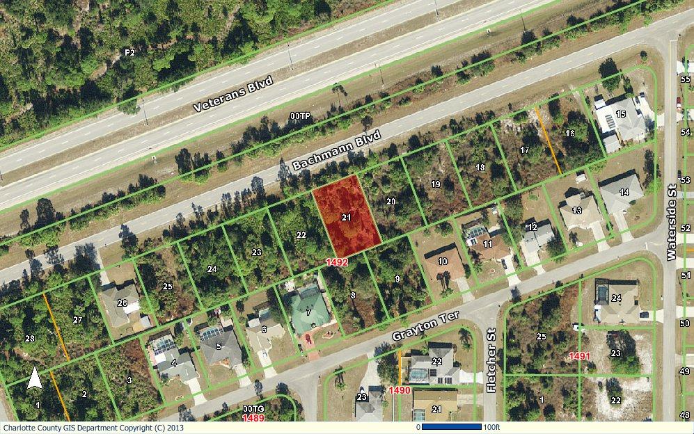
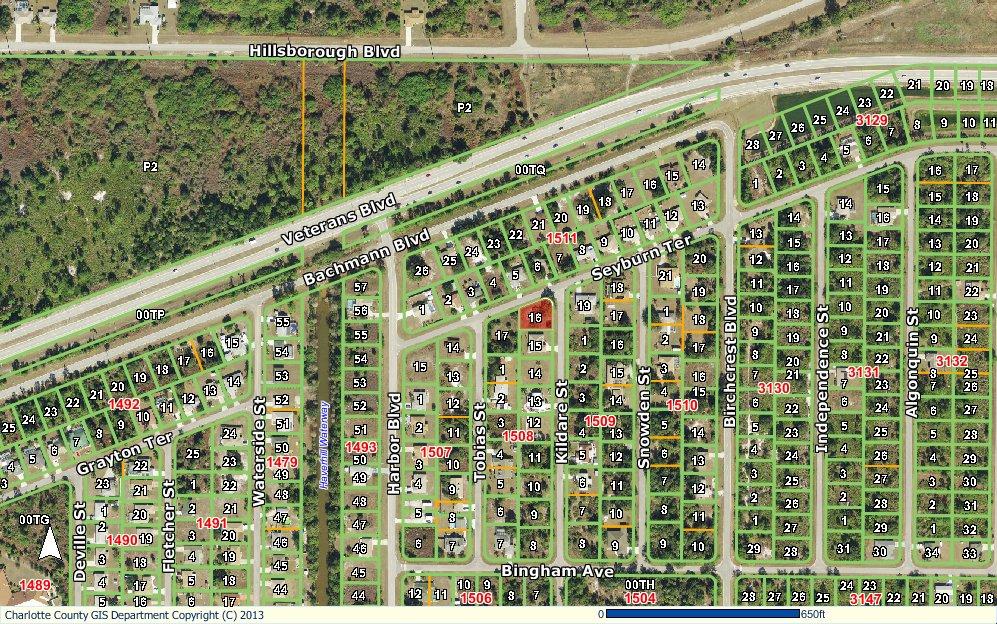
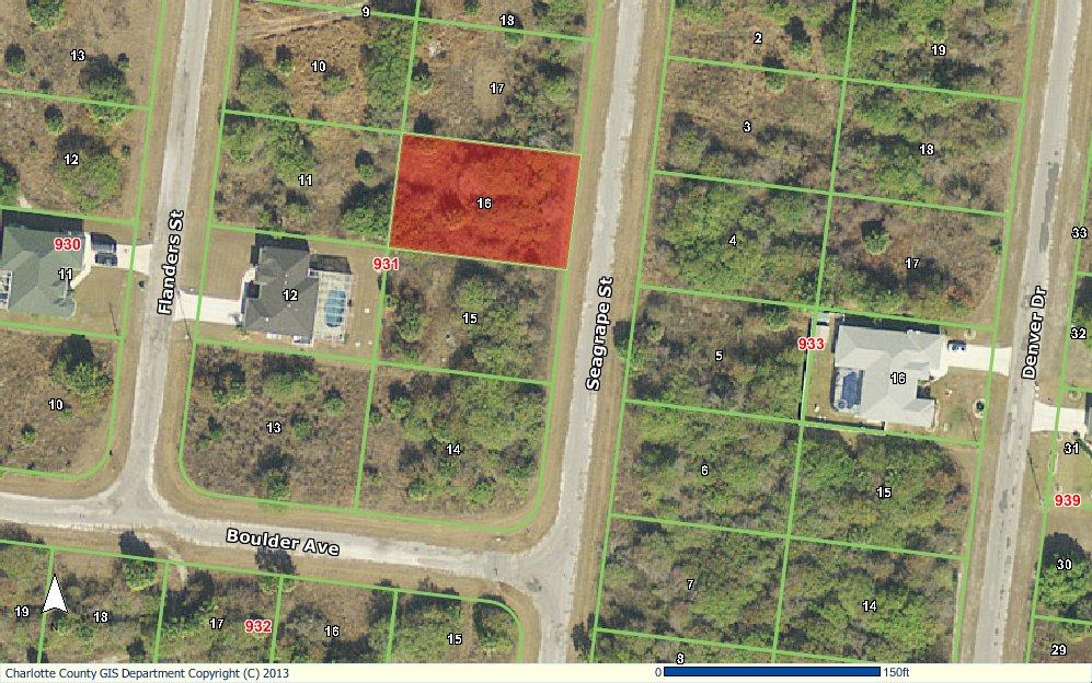
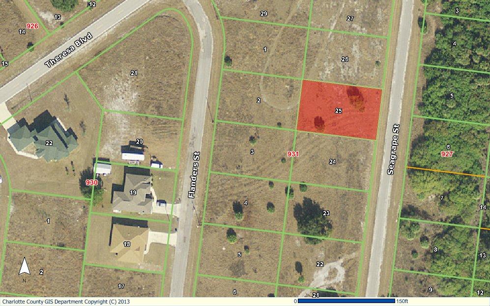
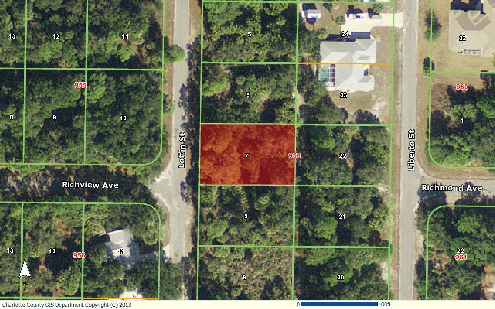
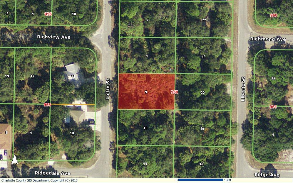
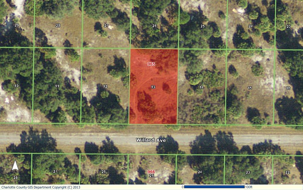
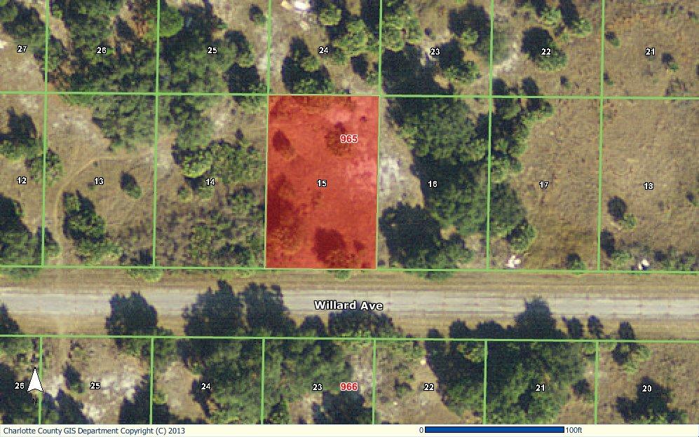
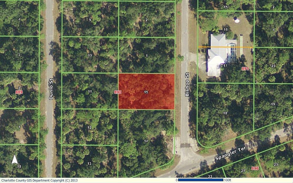
2 PORT CHARLOTTE BUILDERS/INVESTORS PACKAGE Lot Area Highlighted In Red BACHMANN BLVD PORT CHARLOTTE PCH $7,000 WATER 93 KILDARE ST PORT CHARLOTTE PCH $7,000 WATER BUTTERCUT AVE PORT CHARLOTTE PCH LTS 4, 5, 6 $21,000 NA 155 SEAGRAPE ST PORT CHARLOTTE PCH $7,000 NA 83 SEAGRAPE ST PORT CHARLOTTE PCH $7,000 NA 88 LOFTIN ST PORT CHARLOTTE PCH $7,000 NA 104 LOFTIN ST PORT CHARLOTTE PCH $7,000 NA RUSKIN AVE PORT CHARLOTTE PCH $7,000 NA WILLARD AVE PORT CHARLOTTE PCH $7,000 NA WILLARD AVE PORT CHARLOTTE PCH $7,000 NA LORETTE AVE PORT CHARLOTTE PCH $7,000 NA ELROSE AVE PORT CHARLOTTE PCH $7,000 NA ELROSE AVE PORT CHARLOTTE PCH $7,000 NA 87 ATWATER ST PORT CHARLOTTE PCH $7,000 NA 195 BISHOP ST PORT CHARLOTTE PCH $7,000 NA
3
4 http: / &g... Page 1 of 2 10/25/2013 Charlotte County Property Appraiser Paul L. Polk, CFA Real Property Record Show 2014 Show 2013 Show 2012 Show 2011 Show 2010 If a discrepancy is discovered in your property's records, or those of another, please bring it to our attention immediately. General Parcel Information for for the 2014 Tax Roll Parcel ID: Property Address: Old Parcel ID Number: Property Zip Code: Business Name: Section-Township- Range: BACHMANN BLVD Map Number: 4A03N Zoning Code: RSF3.5 Current Use: VACANT RESIDENTIAL Roads: PAVED Future Use (Comp. Plan): Utilities: LOW DENSITY RESIDENTIAL WATER Taxing District: 104 Market Area / Neighborhood: Waterfront: NO SOH Base Year: 01 /08 Firm Panel Floodway SFHA Flood Zone FEMA Flood Zone (Effective 5/5/2003) FIPS COBRA Community 0063F OUT X 12015C COBRA_OUT Base Flood Elevation (ft.) Letter of Map Revision (LOMR) *Ifparcelhasmore than1 flood zone, refer tothe flood mapsavailable onthe GIS website byclickingonview Map below. Click here for definitions. For more information, please contact BuildingConstructionServicesat Ownership Information HSIAO SHANCHU-TANG & YL-H NO 20 ALLEY 31 LN 152 RUEISONG ST SIJHIH CITY TAIPEI COUNTY 221 TAIWAN, REPUBLIC OF CHINA Ownership current through: 10/17/2013 Date Book/Page Sales Information Sales Codes Qualification/ Disqualification Code Selling Price 11/1/ /910 VACANT $3,500 11/1/ /1288 VACANT $18,095 11/1/ /1288 VACANT $18,095 Click on the book/page to view transaction document images on the Clerk of the Circuit Court's web site. Click on Qualification/Disqualification Code for description of code. Codes are not available prior to 2003.
5 Page 2 of Preliminary tax roll values are not yet avalaible. Preliminary values are typically available mid-august. For the most up to date values, see the 2013 tax year. Tax Information Line Description 1 PCH Information Use Zoning Unit Type RSF3.5 FRONT FOOT Unit Rate Table/ Units Depth Factor Acreage $ / Value may be adjusted due to scrub jay habitat. To determine if this parcel is within scrub jay habitat click here. Short Legal PCH Legal Description Legal Description PORT CHARLOTTE SEC34 BLK1492 LT21 300/ / / / /1288 Data Last Updated:10/25/2013-Printed On:10/25/2013. View Map New Search Help Home Send Us Copyright Charlotte CountyPropertyAppraiser. A lrightsreserved. http: / 10/25/2013
6
7 Page 1 of 2 Charlotte County Property Appraiser Paul L. Polk, CFA Real Property Record Show 2014 Show 2013 Show 2012 Show 2011 Show 2010 If a discrepancy is discovered in your property's records, or those of another, please bring it to our attention immediately. General Parcel Information for for the 2013 Tax Roll Parcel ID: Property Address: Old Parcel ID Number: Property Zip Code: Business Name: Section-Township- Range: SEYBURN TER or 93 KILDARE ST Map Number: 4A03N Zoning Code: RSF3.5 Current Use: VACANT RESIDENTIAL Roads: PAVED Future Use (Comp. Plan): Utilities: LOW DENSITY RESIDENTIAL WATER Taxing District: 104 Market Area / Neighborhood: Waterfront: NO SOH Base Year: 01 /08 Ownership Information SOUTHWIND PROPERTIES LLC % LLOYD L TAYLOR 6648 CONCH CT BOYNTON BEACH, FL Sales Information Date Book/Page Sales Codes Qualification/ Disqualification Code Selling Price 11/1/ /489 VACANT $7,500 6/1/ /1285 VACANT 05 $6,500 8/1/ / /1/ /856 VAC- MULTI VAC- MULTI 02 $68, $100 Click on the book/page to view transaction document images on the Clerk of the Circuit Court's web site. Click on Qualification/Disqualification Code for description of code. Codes are not available prior to Value Summary Improvements Building Damage Total http: / &g... 10/25/2013
8 Page 2 of 2 Cost Approach Income Approach Market Approach $3,802 $3,802 Classified Value 2013 Certified Tax Roll Values, as of January 1, 2013 Certified Just Value (Just Value reflects adjustment.): Non-School School $3,232 $3,232 Certified Assessed Value: $3,232 $3,232 Certified Exemptions: Certified Taxable Value: $3,232 $3,232 Duplicate Notice of Proposed Property Taxes Tax Information Line Description 1 PCH Information Use Zoning Unit Type RSF3.5 FRONT FOOT Unit Rate Table/ Units Depth Factor Acreage $ / Value may be adjusted due to scrub jay habitat. To determine if this parcel is within scrub jay habitat click here. Short Legal PCH Legal Description Legal Description PORT CHARLOTTE SEC34 BLK1508 LT / / / /489 DC1315/ / / / /856 Data Last Updated:10/25/2013-Printed On:10/25/2013. View Map New Search Help Home Send Us Copyright Charlotte CountyPropertyAppraiser. A lrightsreserved. http: / &g... 10/25/2013
9
10 &a... Page 1 of 2 11/19/2013 Charlotte County Property Appraiser Paul L. Polk, CFA Real Property Record Show 2014 Show 2013 Show 2012 Show 2011 Show 2010 If a discrepancy is discovered in your property's records, or those of another, please bring it to our attention immediately. General Parcel Information for for the 2014 Tax Roll Parcel ID: Property Address: Old Parcel ID Number: Property Zip Code: Business Name: Section-Township- Range: 155 SEAGRAPE ST Map Number: 4A05N Zoning Code: RSF3.5 Current Use: VACANT RESIDENTIAL Roads: PAVED Future Use (Comp. Plan): Utilities: LOW DENSITY RESIDENTIAL NONE Taxing District: 104 Market Area / Neighborhood: Waterfront: NO SOH Base Year: 01 /07 Firm Panel Floodway SFHA Flood Zone FEMA Flood Zone (Effective 5/5/2003) FIPS COBRA Community 0044F OUT X 12015C COBRA_OUT F OUT X 12015C COBRA_OUT Base Flood Elevation (ft.) Letter of Map Revision (LOMR) *If parcel has more than 1 flood zone, refer to the flood maps available on the GIS web site by clicking on View Map below. Click here for definitions. For more information, please contact Building Construction Services at HOWARD MARY E %HOWARD NANCY 3345 SARATOGA ST UNIT C WELLINGTON, CO Ownership Information Ownership current through: 11/14/2013
11 Page 2 of Preliminary tax roll values are not yet avalaible. Preliminary values are typically available mid-august. For the most up to date values, see the 2013 tax year. Tax Information Line Description 1 PCH Information Use Zoning Unit Type RSF3.5 FRONT FOOT Unit Rate Table/ Units Depth Factor Acreage $ / Value may be adjusted due to scrub jay habitat. To determine if this parcel is within scrub jay habitat click here. Short Legal Legal Description Legal Description PCH PORT CHARLOTTE SEC17 BLK931 LT / /148 Data Last Updated: 11/19/2013- Printed On: 11/19/2013. View Map New Search Help Home Send Us Copyright Charlotte County Property Appraiser. All rights reserved. &a... 11/19/2013
12
13 &a... Page 1 of 2 11/19/2013 Charlotte County Property Appraiser Paul L. Polk, CFA Real Property Record Show 2014 Show 2013 Show 2012 Show 2011 Show 2010 If a discrepancy is discovered in your property's records, or those of another, please bring it to our attention immediately. General Parcel Information for for the 2013 Tax Roll Parcel ID: Property Address: Old Parcel ID Number: Property Zip Code: Business Name: Section-Township- Range: 83 SEAGRAPE ST Map Number: 4A05N Zoning Code: RSF3.5 Current Use: VACANT RESIDENTIAL Roads: PAVED Future Use (Comp. Plan): Utilities: LOW DENSITY RESIDENTIAL NONE Taxing District: 104 Market Area / Neighborhood: Waterfront: NO SOH Base Year: 01 /07 Ownership Information RYAN JAMES E %REEVES PATRICIA 64 ST JOHNS AVE BUFFALO, NY Cost Approach Income Approach 2013 Value Summary Improvements Building Damage Total Market Approach $2,960 $2,960 Classified Value 2013 Certified Tax Roll Values, as of January 1, 2013 Certified Just Value (Just Value reflects adjustment.): Non-School School $2,516 $2,516
14 Page 2 of 2 Certified Assessed Value: $2,516 $2,516 Certified Exemptions: Certified Taxable Value: $2,516 $2,516 Duplicate Notice of Proposed Property Taxes Tax Information Line Description 1 PCH Information Use Zoning Unit Type RSF3.5 FRONT FOOT Unit Rate Table/ Units Depth Factor Acreage $ / Value may be adjusted due to scrub jay habitat. To determine if this parcel is within scrub jay habitat click here. Short Legal Legal Description Legal Description PCH PORT CHARLOTTE SEC17 BLK931 LT /941 Data Last Updated: 11/19/2013- Printed On: 11/19/2013. View Map New Search Help Home Send Us Copyright Charlotte County Property Appraiser. All rights reserved. &a... 11/19/2013
15
16 &a... Page 1 of 2 11/19/2013 Charlotte County Property Appraiser Paul L. Polk, CFA Real Property Record Show 2014 Show 2013 Show 2012 Show 2011 Show 2010 If a discrepancy is discovered in your property's records, or those of another, please bring it to our attention immediately. General Parcel Information for for the 2013 Tax Roll Parcel ID: Property Address: 88 LOFTIN ST Old Parcel ID Number: Property Zip Code: Business Name: Section-Township- Range: Map Number: 4A05N Zoning Code: RSF3.5 Current Use: VACANT RESIDENTIAL Roads: PAVED Future Use (Comp. Plan): Utilities: LOW DENSITY RESIDENTIAL NONE Taxing District: 104 Market Area / Neighborhood: Waterfront: NO SOH Base Year: 01 /07 Ownership Information BUFFALO CREDIT UNION %SUMMERS HARDWARE & SUPPLY CO BOX 210 JOHNSON CITY, TN Sales Information Date Book/Page Sales Codes 9/11/ /592 VAC- MULTI Qualification/ Selling Disqualification Price Code 19 $100 10/8/ /268 VACANT 19 $100 Click on the book/page to view transaction document images on the Clerk of the Circuit Court's web site. Click on Qualification/Disqualification Code for description of code. Codes are not available prior to Cost Approach Income Approach 2013 Value Summary Improvements Building Damage Total Market Approach $2,960 $2,960 Classified Value
17 Page 2 of Certified Tax Roll Values, as of January 1, 2013 Certified Just Value (Just Value reflects adjustment.): Non-School School $2,516 $2,516 Certified Assessed Value: $2,516 $2,516 Certified Exemptions: Certified Taxable Value: $2,516 $2,516 Duplicate Notice of Proposed Property Taxes Tax Information Line Description 1 PCH Information Use Zoning Unit Type RSF3.5 FRONT FOOT Unit Rate Table/ Units Depth Factor Acreage $ / Value may be adjusted due to scrub jay habitat. To determine if this parcel is within scrub jay habitat click here. Short Legal PCH Legal Description Legal Description PORT CHARLOTTE SEC17 BLK958 LT7 199/ /07 CT3324/592 CD3330/268 Data Last Updated: 11/19/2013- Printed On: 11/19/2013. View Map New Search Help Home Send Us Copyright Charlotte County Property Appraiser. All rights reserved. &a... 11/19/2013
18
19 &a... Page 1 of 2 11/19/2013 Charlotte County Property Appraiser Paul L. Polk, CFA Real Property Record Show 2014 Show 2013 Show 2012 Show 2011 Show 2010 If a discrepancy is discovered in your property's records, or those of another, please bring it to our attention immediately. General Parcel Information for for the 2013 Tax Roll Parcel ID: Property Address: 104 LOFTIN ST Old Parcel ID Number: Property Zip Code: Business Name: Section-Township- Range: Map Number: 4A05N Zoning Code: RSF3.5 Current Use: VACANT RESIDENTIAL Roads: PAVED Future Use (Comp. Plan): Utilities: LOW DENSITY RESIDENTIAL NONE Taxing District: 104 Market Area / Neighborhood: Waterfront: NO SOH Base Year: 01 /07 Ownership Information THIMGAN RICHARD L & DORIS J 2707 APACHE RD GRAND ISLAND, NE Cost Approach Income Approach 2013 Value Summary Improvements Building Damage Total Market Approach $2,960 $2,960 Classified Value 2013 Certified Tax Roll Values, as of January 1, 2013 Certified Just Value (Just Value reflects adjustment.): Non-School School $2,516 $2,516 Certified Assessed Value: $2,516 $2,516
20 Page 2 of 2 Certified Exemptions: Certified Taxable Value: $2,516 $2,516 Duplicate Notice of Proposed Property Taxes Tax Information Line Description 1 PCH Information Use Zoning Unit Type RSF3.5 FRONT FOOT Unit Rate Table/ Units Depth Factor Acreage $ / Value may be adjusted due to scrub jay habitat. To determine if this parcel is within scrub jay habitat click here. Short Legal Legal Description Legal Description PCH PORT CHARLOTTE SEC17 BLK958 LT 9 223/206 Data Last Updated: 11/19/2013- Printed On: 11/19/2013. View Map New Search Help Home Send Us Copyright Charlotte County Property Appraiser. All rights reserved. &a... 11/19/2013
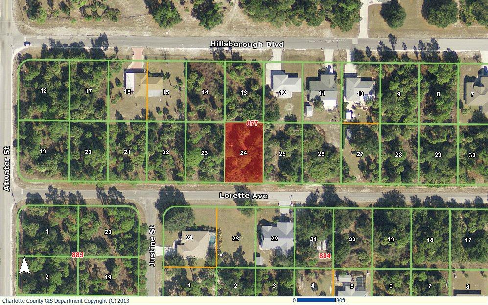
21
22 Page 1 of 2 Charlotte County Property Appraiser Paul L. Polk, CFA Real Property Record Show 2014 Show 2013 Show 2012 Show 2011 Show 2010 If a discrepancy is discovered in your property's records, or those of another, please bring it to our attention immediately. General Parcel Information for for the 2013 Tax Roll Parcel ID: Property Address: Old Parcel ID Number: Property Zip Code: Business Name: Section-Township- Range: WILLARD AVE Map Number: 4A05N Zoning Code: RSF3.5 Current Use: VACANT RESIDENTIAL Roads: PAVED Future Use (Comp. Plan): Utilities: LOW DENSITY RESIDENTIAL NONE Taxing District: 104 Market Area / Neighborhood: Waterfront: NO SOH Base Year: 01 /07 Ownership Information ANDERSON CLAYON HOOK CREEK BLVD ROSEDALE, NY Sales Information Date Book/Page Sales Codes Qualification/ Disqualification Code Selling Price 2/1/ /1823 VACANT $1,900 2/6/ /1722 VACANT 59 $6,000 2/9/ /1719 VACANT 19 $100 5/30/ /1254 VACANT 05 $13,000 Click on the book/page to view transaction document images on the Clerk of the Circuit Court's web site. Click on Qualification/Disqualification Code for description of code. Codes are not available prior to Cost Approach Income Approach 2013 Value Summary Improvements Building Damage Total Market Approach $2,960 $2,960 &a... 11/19/2013
23 Page 2 of 2 Classified Value 2013 Certified Tax Roll Values, as of January 1, 2013 Certified Just Value (Just Value reflects adjustment.): Non-School School $2,516 $2,516 Certified Assessed Value: $2,516 $2,516 Certified Exemptions: Certified Taxable Value: $2,516 $2,516 Duplicate Notice of Proposed Property Taxes Tax Information Line Description 1 PCH Information Use Zoning Unit Type RSF3.5 FRONT FOOT Unit Rate Table/ Units Depth Factor Acreage $ / Value may be adjusted due to scrub jay habitat. To determine if this parcel is within scrub jay habitat click here. Short Legal PCH Legal Description Legal Description PORT CHARLOTTE SEC17 BLK965 LT13 133/ / / / /1722 PR MHB NT3116/1721-MHB WILL3126/ /1061 OSA3126/ /1254 Data Last Updated: 11/19/2013- Printed On: 11/19/2013. View Map New Search Help Home Send Us Copyright Charlotte County Property Appraiser. All rights reserved. &a... 11/19/2013
24
25 &a... Page 1 of 2 11/19/2013 Charlotte County Property Appraiser Paul L. Polk, CFA Real Property Record Show 2014 Show 2013 Show 2012 Show 2011 Show 2010 If a discrepancy is discovered in your property's records, or those of another, please bring it to our attention immediately. General Parcel Information for for the 2013 Tax Roll Parcel ID: Property Address: Old Parcel ID Number: Property Zip Code: Business Name: Section-Township- Range: WILLARD AVE Map Number: 4A05N Zoning Code: RSF3.5 Current Use: VACANT RESIDENTIAL Roads: PAVED Future Use (Comp. Plan): Utilities: LOW DENSITY RESIDENTIAL NONE Taxing District: 104 Market Area / Neighborhood: Waterfront: NO SOH Base Year: 01 /07 Ownership Information JANVIER AMANDA L & E P-L 4176 DERBY DR DAVIE, FL Sales Information Date Book/Page Sales Codes Qualification/ Selling Disqualification Price Code 10/1/ /54 VACANT 05 $800 11/1/ /734 VACANT 19 $100 3/30/ /736 VACANT 11 $100 Click on the book/page to view transaction document images on the Clerk of the Circuit Court's web site. Click on Qualification/Disqualification Code for description of code. Codes are not available prior to Cost Approach Income Approach 2013 Value Summary Improvements Building Damage Total Market Approach $2,960 $2,960 Classified Value
26 Page 2 of Certified Tax Roll Values, as of January 1, 2013 Certified Just Value (Just Value reflects adjustment.): Non-School School $2,516 $2,516 Certified Assessed Value: $2,516 $2,516 Certified Exemptions: Certified Taxable Value: $2,516 $2,516 Duplicate Notice of Proposed Property Taxes Tax Information Line Description 1 PCH Information Use Zoning Unit Type RSF3.5 FRONT FOOT Unit Rate Table/ Units Depth Factor Acreage $ / Value may be adjusted due to scrub jay habitat. To determine if this parcel is within scrub jay habitat click here. Short Legal PCH Legal Description Legal Description PORT CHARLOTTE SEC17 BLK965 LT /19 DC557/ / / / /736 Data Last Updated: 11/19/2013- Printed On: 11/19/2013. View Map New Search Help Home Send Us Copyright Charlotte County Property Appraiser. All rights reserved. &a... 11/19/2013
27
28 &a... Page 1 of 2 11/19/2013 Charlotte County Property Appraiser Paul L. Polk, CFA Real Property Record Show 2014 Show 2013 Show 2012 Show 2011 Show 2010 If a discrepancy is discovered in your property's records, or those of another, please bring it to our attention immediately. General Parcel Information for for the 2013 Tax Roll Parcel ID: Property Address: Old Parcel ID Number: Property Zip Code: Business Name: Section-Township- Range: LORETTE AVE Map Number: 4A04N Zoning Code: RSF3.5 Current Use: VACANT RESIDENTIAL Roads: PAVED Future Use (Comp. Plan): Utilities: LOW DENSITY RESIDENTIAL NONE Taxing District: 104 Market Area / Neighborhood: Waterfront: NO SOH Base Year: 01 /07 Ownership Information PANDOLFO THOMAS W & ANGELA %ROBERT PANDOLFO 1250 W MARION AVE UNIT 122 PUNTA GORDA, FL Cost Approach Income Approach 2013 Value Summary Improvements Building Damage Total Market Approach $2,960 $2,960 Classified Value 2013 Certified Tax Roll Values, as of January 1, 2013 Certified Just Value (Just Value reflects adjustment.): Non-School School $2,516 $2,516
29 Page 2 of 2 Certified Assessed Value: $2,516 $2,516 Certified Exemptions: Certified Taxable Value: $2,516 $2,516 Duplicate Notice of Proposed Property Taxes Tax Information Line Description 1 PCH Information Use Zoning Unit Type RSF3.5 FRONT FOOT Unit Rate Table/ Units Depth Factor Acreage $ / Value may be adjusted due to scrub jay habitat. To determine if this parcel is within scrub jay habitat click here. Short Legal Legal Description Legal Description PCH PORT CHARLOTTE SEC19 BLK877 LT /357 Data Last Updated: 11/19/2013- Printed On: 11/19/2013. View Map New Search Help Home Send Us Copyright Charlotte County Property Appraiser. All rights reserved. &a... 11/19/2013
30
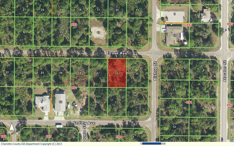
31 &a... Page 1 of 2 11/19/2013 Charlotte County Property Appraiser Paul L. Polk, CFA Real Property Record Show 2014 Show 2013 Show 2012 Show 2011 Show 2010 If a discrepancy is discovered in your property's records, or those of another, please bring it to our attention immediately. General Parcel Information for for the 2013 Tax Roll Parcel ID: Property Address: Old Parcel ID Number: Property Zip Code: Business Name: Section-Township- Range: ELROSE AVE Map Number: 4A04N Zoning Code: RSF3.5 Current Use: VACANT RESIDENTIAL Roads: PAVED Future Use (Comp. Plan): Utilities: LOW DENSITY RESIDENTIAL NONE Taxing District: 104 Market Area / Neighborhood: Waterfront: NO SOH Base Year: 01 /07 Ownership Information MITCHELL ROBERT 31 NW 132ND TERRACE OCALA, FL Sales Information Date Book/Page Sales Codes Qualification/ Selling Disqualification Price Code 3/1/ /1006 VACANT $2,500 11/1/ /482 VACANT $1,500 8/1/ /1047 VAC- MULTI $4,100 Click on the book/page to view transaction document images on the Clerk of the Circuit Court's web site. Click on Qualification/Disqualification Code for description of code. Codes are not available prior to Cost Approach Income Approach 2013 Value Summary Improvements Building Damage Total Market Approach $2,960 $2,960 Classified Value
32 Page 2 of Certified Tax Roll Values, as of January 1, 2013 Certified Just Value (Just Value reflects adjustment.): Non-School School $2,516 $2,516 Certified Assessed Value: $2,516 $2,516 Certified Exemptions: Certified Taxable Value: $2,516 $2,516 Duplicate Notice of Proposed Property Taxes Tax Information Line Description 1 PCH Information Use Zoning Unit Type RSF3.5 FRONT FOOT Unit Rate Table/ Units Depth Factor Acreage $ / Value may be adjusted due to scrub jay habitat. To determine if this parcel is within scrub jay habitat click here. Short Legal Legal Description Legal Description PCH PORT CHARLOTTE SEC19 BLK881 LT / / /1047 Data Last Updated: 11/19/2013- Printed On: 11/19/2013. View Map New Search Help Home Send Us Copyright Charlotte County Property Appraiser. All rights reserved. &a... 11/19/2013
33
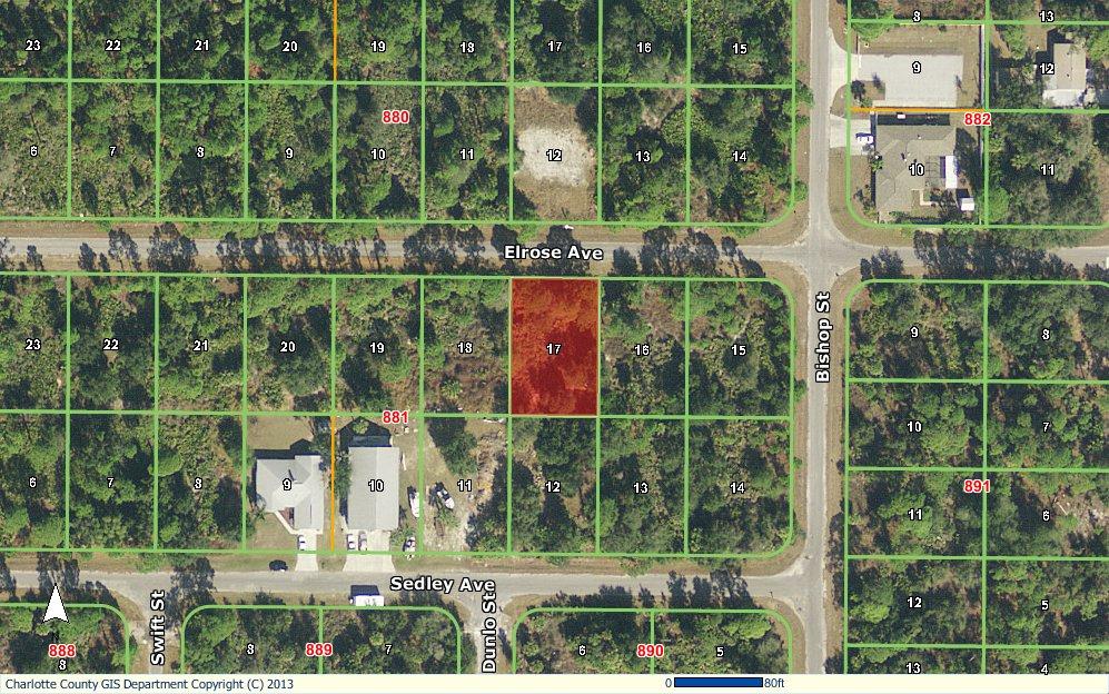
34 &a... Page 1 of 2 11/19/2013 Charlotte County Property Appraiser Paul L. Polk, CFA Real Property Record Show 2014 Show 2013 Show 2012 Show 2011 Show 2010 If a discrepancy is discovered in your property's records, or those of another, please bring it to our attention immediately. General Parcel Information for for the 2013 Tax Roll Parcel ID: Property Address: Old Parcel ID Number: Property Zip Code: Business Name: Section-Township- Range: ELROSE AVE Map Number: 4A04N Zoning Code: RSF3.5 Current Use: VACANT RESIDENTIAL Roads: PAVED Future Use (Comp. Plan): Utilities: LOW DENSITY RESIDENTIAL NONE Taxing District: 104 Market Area / Neighborhood: Waterfront: NO SOH Base Year: 01 /07 Ownership Information MITCHELL ROBERT 31 NW 132ND TERRACE OCALA, FL Sales Information Date Book/Page Sales Codes Qualification/ Selling Disqualification Price Code 8/1/ /1196 VACANT $1,500 9/1/ /1726 VACANT $100 4/1/ /427 VACANT $1,000 8/1/ /1047 VAC- MULTI $4,100 Click on the book/page to view transaction document images on the Clerk of the Circuit Court's web site. Click on Qualification/Disqualification Code for description of code. Codes are not available prior to Cost Approach Income Approach 2013 Value Summary Improvements Building Damage Total Market Approach $2,960 $2,960
35 Page 2 of 2 Classified Value 2013 Certified Tax Roll Values, as of January 1, 2013 Certified Just Value (Just Value reflects adjustment.): Non-School School $2,516 $2,516 Certified Assessed Value: $2,516 $2,516 Certified Exemptions: Certified Taxable Value: $2,516 $2,516 Duplicate Notice of Proposed Property Taxes Tax Information Line Description 1 PCH Information Use Zoning Unit Type RSF3.5 FRONT FOOT Unit Rate Table/ Units Depth Factor Acreage $ / Value may be adjusted due to scrub jay habitat. To determine if this parcel is within scrub jay habitat click here. Short Legal PCH Legal Description Legal Description PORT CHARLOTTE SEC19 BLK881 LT17 345/ / / / / /1047 Data Last Updated: 11/19/2013- Printed On: 11/19/2013. View Map New Search Help Home Send Us Copyright Charlotte County Property Appraiser. All rights reserved. &a... 11/19/2013
36
37 &a... Page 1 of 2 11/19/2013 Charlotte County Property Appraiser Paul L. Polk, CFA Real Property Record Show 2014 Show 2013 Show 2012 Show 2011 Show 2010 If a discrepancy is discovered in your property's records, or those of another, please bring it to our attention immediately. General Parcel Information for for the 2013 Tax Roll Parcel ID: Property Address: Old Parcel ID Number: Property Zip Code: Business Name: Section-Township- Range: 87 ATWATER ST Map Number: 4A04N Zoning Code: RSF3.5 Current Use: VACANT RESIDENTIAL Roads: PAVED Future Use (Comp. Plan): Utilities: LOW DENSITY RESIDENTIAL NONE Taxing District: 104 Market Area / Neighborhood: Waterfront: NO SOH Base Year: 01 /07 Ownership Information SUPINSKI ZBIGNIEW 25 LANSDOWNE LN PALM COAST, FL Sales Information Date Book/Page Sales Codes Qualification/ Disqualification Code Selling Price 10/1/ /631 VACANT 19 $100 10/1/ /632 VACANT 19 $100 10/1/ /633 VACANT 19 $100 10/1/ /634 VACANT 05 $22,000 1/2/ /1769 VACANT $35,000 Click on the book/page to view transaction document images on the Clerk of the Circuit Court's web site. Click on Qualification/Disqualification Code for description of code. Codes are not available prior to Cost Approach Income Approach 2013 Value Summary Improvements Building Damage Total
38 Page 2 of 2 Market Approach $2,960 $2,960 Classified Value 2013 Certified Tax Roll Values, as of January 1, 2013 Certified Just Value (Just Value reflects adjustment.): Non-School School $2,516 $2,516 Certified Assessed Value: $2,516 $2,516 Certified Exemptions: Certified Taxable Value: $2,516 $2,516 Duplicate Notice of Proposed Property Taxes Tax Information Line Description 1 PCH Information Use Zoning Unit Type RSF3.5 FRONT FOOT Unit Rate Table/ Units Depth Factor Acreage $ / Value may be adjusted due to scrub jay habitat. To determine if this parcel is within scrub jay habitat click here. Short Legal PCH Legal Description Legal Description PORT CHARLOTTE SEC19 BLK882 LT /560 DC1241/ / / /1769 Data Last Updated: 11/19/2013- Printed On: 11/19/2013. View Map New Search Help Home Send Us Copyright Charlotte County Property Appraiser. All rights reserved. 11/19/2013
39
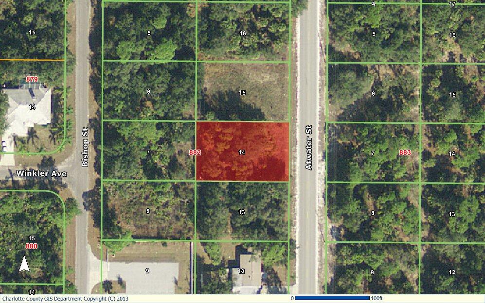
40 &a... Page 1 of 2 11/19/2013 Charlotte County Property Appraiser Paul L. Polk, CFA Real Property Record Show 2014 Show 2013 Show 2012 Show 2011 Show 2010 If a discrepancy is discovered in your property's records, or those of another, please bring it to our attention immediately. General Parcel Information for for the 2013 Tax Roll Parcel ID: Property Address: 195 BISHOP ST Old Parcel ID Number: Property Zip Code: Business Name: Section-Township- Range: Map Number: 4A04N Zoning Code: RSF3.5 Current Use: VACANT RESIDENTIAL Roads: PAVED Future Use (Comp. Plan): Utilities: LOW DENSITY RESIDENTIAL NONE Taxing District: 104 Market Area / Neighborhood: Waterfront: NO SOH Base Year: 01 /07 Ownership Information WILLIAMS ALMA L & H H WILLIAMS 5479 EDENCROFT CRESENT MISSISSAUGA, ON L5M 4M9 CANADA Date Book/Page Sales Information Sales Codes Qualification/ Disqualification Code Selling Price 7/1/ /1862 VACANT $4,400 1/1/ /871 IMPROVED $35,000 Click on the book/page to view transaction document images on the Clerk of the Circuit Court's web site. Click on Qualification/Disqualification Code for description of code. Codes are not available prior to Cost Approach Income Approach 2013 Value Summary Improvements Building Damage Total Market Approach $2,960 $2,960 Classified Value
41 Page 2 of Certified Tax Roll Values, as of January 1, 2013 Certified Just Value (Just Value reflects adjustment.): Non-School School $2,516 $2,516 Certified Assessed Value: $2,516 $2,516 Certified Exemptions: Certified Taxable Value: $2,516 $2,516 Duplicate Notice of Proposed Property Taxes Tax Information Line Description 1 PCH Information Use Zoning Unit Type RSF3.5 FRONT FOOT Unit Rate Table/ Units Depth Factor Acreage $ / Value may be adjusted due to scrub jay habitat. To determine if this parcel is within scrub jay habitat click here. Short Legal Legal Description Legal Description PCH PORT CHARLOTTE SEC19 BLK890 LT15 303/ /871 Data Last Updated: 11/19/2013- Printed On: 11/19/2013. View Map New Search Help Home Send Us Copyright Charlotte County Property Appraiser. All rights reserved. &a... 11/19/2013
42 Development Regulations Chapter 3-9. Zoning Article II. Districts Regulations Sec RSF Sec Residential Single-family (RSF) (a) Intent. The purpose and intent of these districts is to provide for single-family residential dwellings and other uses normally associated therewith. Among RSF-2, RSF-3.5 and RSF-5 districts, there are variations in requirements for lot area, width, and certain yards. (b) Permitted Uses and Structures (P): (1) Assisted living facility or day care center, adult, six or less. (See Sec Adult Congregate Living Facilities) (2) Emergency services. (3) Manufactured home (DCA), minimum requirement is 150 miles per hour exposure C. (4) Minor Home Occupation. (see Sec Home Occupations) (5) Model home. (see Sec Model Homes) (6) Noncommercial boat docks. (7) Park, public or not-for-profit. (8) Single-family detached, which may have a guest suite that is structurally attached, with or without cooking facilities. (9) Telecommunications facility, 50 feet or less in height. (see Sec Communication Towers) (c) Permitted Accessory Uses and Structures: Uses and structures which are customarily accessory and clearly incidental to permitted and conditional uses and structures are permitted in this district. (1) Boat lifts, boat ramps, and noncommercial boat docks. (2) Carports, garages, and storage structures. a. Detached accessory structures greater than 250 square feet in footprint shall be compatible in appearance with the primary residence, at a minimum, materials and color shall be compatible with the primary residence. b. The total footprint of all detached accessory structures shall not exceed 10% of the parcel size or 1,000 square feet, whichever is greater for a property less than a half acre. If the property is one half acre or more in size, the total footprint of all detached accessory structures shall not exceed 3,000 square feet. The property owner(s) may apply for a Special Exception to exceed the total maximum accessory structures size limitations contained in this Section. c. Detached accessory structures shall be located behind the leading edge of the living area of the residence except carports and garages, but must maintain required setbacks. d. Construction trailers and cargo containers are prohibited. (3) Fences or walls which may be permitted prior to the principal uses and structures. (4) Greenhouses and other horticultural uses, provided no retail sales are made on the premises. (5) Guest suite, detached, consisting of living and sanitary facilities only. Cooking facilities shall not be permitted in a detached guest suite. It must meet all applicable development standards set forth in the zoning district. (6) Keeping of pets, excluding animal breeding, boarding, and training. November 2014 Adoption 1
43 Development Regulations Chapter 3-9. Zoning Article II. Districts Regulations Sec RSF (7) Swimming pools, tennis courts, or other similar noncommercial recreational uses and structures. (d) Conditional Uses and Structures (C): (For rules and regulations for any use designated as Conditional Use or Structure, see Sec Conditional Uses and Structures) (e) (f) (1) Bed and breakfast, 1 or 2 bedrooms. (2) Clubhouse. (3) Cluster housing. (see Sec Cluster Housing) (4) Guest home. (5) Subdivided lots with 50 foot wide frontage and 5,000 square foot. Prohibited Uses and Structures: Any use or structure not expressly or by reasonable implication permitted herein or permitted by Special Exception, including but not limited to mobile homes, commercial parking lots and private clubs not otherwise permitted, or permitted by Special Exception, shall be unlawful in this district. Special Exceptions (S): (For procedure see Sec Special Exceptions) (1) All conditional uses and structures that cannot meet all conditions set forth in this Code. (2) Assisted living facility or day care center, adult, seven or more. (See Sec Adult Congregate Living Facilities) (3) Bed and breakfast, 3 or more bedrooms. (4) Cemetery, mausoleum. (5) Community garden. (6) Day care center, child. (7) Elementary, middle, or high school. (8) Essential services. (See Sec Essential Services) (9) Government uses and facilities. (10) Major Home Occupation. (see Sec Home Occupations) (11) Place of Worship. (see Sec Places of Worship) (12) Private clubs. (13) Telecommunications facility, greater than 50 feet in height. (see Sec Communication Towers) (14) University or college. (15) Yacht clubs, country clubs, and other recreational amenities, including but not limited to tennis courts, basketball courts, and golf courses located on a separate parcel. (16) Such other uses as determined by the Zoning Official or his/her designee to be: a. Appropriate by reasonable implication and intent of the district. b. Similar to another use either explicitly permitted in that district or allowed by Special Exception. c. Not specifically prohibited in that district. November 2014 Adoption 2
44 Development Regulations Chapter 3-9. Zoning Article II. Districts Regulations Sec RSF The BZA shall review a favorable determination of the Zoning Official under this provision at the time the Special Exception application is presented to it. An unfavorable determination of the Zoning Official or his/her designee shall be appealable pursuant to Sec Board of Zoning Appeals. (g) Development Standards: RSF-2 RSF-3.5 RSF-5 Lot (min.) Area (sq. ft.) 20,000 10,000 7,500 Width (ft.) Setbacks (min. ft) Front Side (interior) Side (street) Rear (interior) Rear(interior) for All accessory structures Rear (street) Abutting greenbelt All accessory structures abutting greenbelt Where properties lie anywhere on a barrier island or within 1,200 feet of the water of Charlotte Harbor, the Gulf of Mexico, Lemon Bay, Gasparilla Sound, Placida Harbor, Red Fish Cove, the Myakka River, the Peace River, or Coral Creek, structures must also be constructed in accordance with Sec , Waterfront Property. scape buffers and screening shall be required in this district in accordance with the provisions of Article XXII, Chapter 3-5, of the Code, as the same shall be amended. (h) Signs. Signs shall be in accordance with Sec Abutting water Bulk (max.) Lot coverage of All Buildings 40% 40% 40% Height (ft.) Density (units/acre) (i) Off-street parking. Off-street parking shall be in accordance with Sec November 2014 Adoption 3


45 Site Map 83 Seagrape St, Port Charlotte, Florida, Rings: 1, 3, 5 mile radii Prepared by Esri Latitude: Longitude: August 23, Esri Page 1 of 1
46 Population Summary Market Profile 83 Seagrape St, Port Charlotte, Florida, Prepared by Esri Rings: 1, 3, 5 mile radii Latitude: Longitude: mile 3 miles 5 miles 2000 Total Population 1,052 22,943 61, Total Population 2,250 32,895 83, Total Population 2,446 35,551 90, Group Quarters Total Population 2,621 38,033 96, Annual Rate 1.39% 1.36% 1.38% 2017 Total Daytime Population 1,976 36,979 80,320 Workers ,067 26,670 Residents 1,558 21,912 53,650 Household Summary 2000 Households 414 9,590 26, Average Household Size Households ,666 35, Average Household Size Households ,612 37, Average Household Size Households 1,020 15,555 39, Average Household Size Annual Rate 1.26% 1.26% 1.30% 2010 Families 605 9,009 23, Average Family Size Families 646 9,580 24, Average Family Size Families ,165 26, Average Family Size Annual Rate 1.24% 1.19% 1.23% Housing Unit Summary 2000 Housing Units ,701 30,172 Owner Occupied Housing Units 71.2% 73.1% 72.1% Renter Occupied Housing Units 17.6% 16.6% 15.3% Vacant Housing Units 11.2% 10.4% 12.6% 2010 Housing Units 1,083 16,792 43,976 Owner Occupied Housing Units 62.4% 60.8% 61.0% Renter Occupied Housing Units 20.1% 20.5% 18.7% Vacant Housing Units 17.5% 18.6% 20.3% 2017 Housing Units 1,135 17,716 46,687 Owner Occupied Housing Units 59.7% 58.0% 58.1% Renter Occupied Housing Units 24.8% 24.5% 22.2% Vacant Housing Units 15.6% 17.5% 19.7% 2022 Housing Units 1,192 18,650 49,397 Owner Occupied Housing Units 60.6% 58.8% 58.6% Renter Occupied Housing Units 25.0% 24.6% 22.4% Vacant Housing Units 14.4% 16.6% 19.0% Median Household Income 2017 $45,262 $44,470 $45, $52,192 $50,894 $51,517 Median Home Value 2017 $134,877 $138,887 $146, $163,542 $184,311 $202,851 Per Capita Income 2017 $25,055 $25,321 $25, $29,428 $29,536 $29,228 Median Age Data Note: Household population includes persons not residing in group quarters. Average Household Size is the household population divided by total households. Persons in families include the householder and persons related to the householder by birth, marriage, or adoption. Per Capita Income represents the income received by all persons aged 15 years and over divided by the total population. Source: U.S. Census Bureau, Census 2010 Summary File 1. Esri forecasts for 2017 and 2022 Esri converted Census 2000 data into 2010 geography. August 23, Esri Page 1 of 7
47 2017 Households by Income Market Profile 83 Seagrape St, Port Charlotte, Florida, Prepared by Esri Rings: 1, 3, 5 mile radii Latitude: Longitude: mile 3 miles 5 miles Household Income Base ,612 37,499 <$15, % 9.8% 10.5% $15,000 - $24, % 13.2% 13.2% $25,000 - $34, % 14.3% 13.3% $35,000 - $49, % 18.0% 16.9% $50,000 - $74, % 21.1% 22.2% $75,000 - $99, % 10.9% 11.2% $100,000 - $149, % 8.4% 8.4% $150,000 - $199, % 1.8% 2.1% $200, % 2.5% 2.3% Average Household Income $61,117 $60,266 $60, Households by Income Household Income Base 1,020 15,555 39,993 <$15, % 9.1% 9.9% $15,000 - $24, % 11.8% 11.9% $25,000 - $34, % 12.4% 11.6% $35,000 - $49, % 15.6% 14.6% $50,000 - $74, % 21.0% 21.8% $75,000 - $99, % 13.6% 13.7% $100,000 - $149, % 10.9% 10.8% $150,000 - $199, % 2.2% 2.7% $200, % 3.4% 3.1% Average Household Income $72,130 $70,818 $70, Owner Occupied Housing Units by Value Total ,272 27,138 <$50, % 5.7% 5.8% $50,000 - $99, % 25.7% 23.6% $100,000 - $149, % 23.9% 21.9% $150,000 - $199, % 17.9% 18.3% $200,000 - $249, % 10.7% 11.6% $250,000 - $299, % 7.9% 8.3% $300,000 - $399, % 5.3% 7.0% $400,000 - $499, % 1.6% 1.9% $500,000 - $749, % 0.8% 1.1% $750,000 - $999, % 0.2% 0.2% $1,000, % 0.2% 0.3% Average Home Value $159,366 $163,420 $172, Owner Occupied Housing Units by Value Total ,963 28,928 <$50, % 3.7% 3.5% $50,000 - $99, % 16.6% 14.0% $100,000 - $149, % 18.0% 15.2% $150,000 - $199, % 17.0% 16.5% $200,000 - $249, % 13.1% 14.1% $250,000 - $299, % 12.6% 13.3% $300,000 - $399, % 11.2% 14.6% $400,000 - $499, % 4.8% 5.0% $500,000 - $749, % 2.3% 2.9% $750,000 - $999, % 0.5% 0.5% $1,000, % 0.2% 0.4% Average Home Value $195,672 $211,922 $228,751 Data Note: Income represents the preceding year, expressed in current dollars. Household income includes wage and salary earnings, interest dividends, net rents, pensions, SSI and welfare payments, child support, and alimony. Source: U.S. Census Bureau, Census 2010 Summary File 1. Esri forecasts for 2017 and 2022 Esri converted Census 2000 data into 2010 geography. August 23, Esri Page 2 of 7
48 2010 Population by Age Market Profile 83 Seagrape St, Port Charlotte, Florida, Prepared by Esri Rings: 1, 3, 5 mile radii Latitude: Longitude: mile 3 miles 5 miles Total 2,248 32,890 83, % 5.1% 5.1% % 5.8% 5.6% % 6.0% 5.9% % 10.8% 10.2% % 9.9% 9.7% % 11.4% 11.3% % 14.0% 14.1% % 13.8% 14.2% % 11.7% 12.4% % 7.9% 8.0% % 3.5% 3.4% % 79.1% 79.7% 2017 Population by Age Total 2,445 35,550 90, % 4.9% 4.8% % 5.2% 5.0% % 5.4% 5.3% % 10.6% 10.2% % 11.0% 10.4% % 10.5% 10.3% % 12.4% 12.5% % 14.1% 14.6% % 13.4% 14.2% % 8.4% 8.7% % 4.1% 4.0% % 81.2% 81.8% 2022 Population by Age Total 2,621 38,035 96, % 4.9% 4.8% % 5.2% 5.0% % 5.5% 5.3% % 9.7% 9.4% % 11.6% 10.9% % 11.0% 10.5% % 11.0% 11.1% % 13.7% 14.2% % 13.8% 14.8% % 9.7% 10.1% % 4.0% 4.1% % 81.2% 81.9% 2010 Population by Sex Males 1,072 15,683 40,364 Females 1,178 17,212 43, Population by Sex Males 1,170 17,000 43,704 Females 1,276 18,551 46, Population by Sex Males 1,253 18,212 46,826 Females 1,368 19,821 49,988 Source: U.S. Census Bureau, Census 2010 Summary File 1. Esri forecasts for 2017 and 2022 Esri converted Census 2000 data into 2010 geography. August 23, Esri Page 3 of 7
49 2010 Population by Race/Ethnicity Market Profile 83 Seagrape St, Port Charlotte, Florida, Prepared by Esri Rings: 1, 3, 5 mile radii Latitude: Longitude: mile 3 miles 5 miles Total 2,250 32,895 83,656 White Alone 83.3% 85.1% 85.5% Black Alone 9.6% 8.9% 8.7% American Indian Alone 0.4% 0.3% 0.3% Asian Alone 1.8% 1.5% 1.4% Pacific Islander Alone 0.0% 0.0% 0.1% Some Other Race Alone 2.0% 1.8% 1.7% Two or More Races 2.9% 2.5% 2.3% Hispanic Origin 10.9% 9.5% 8.9% Diversity Index Population by Race/Ethnicity Total 2,446 35,552 90,408 White Alone 81.1% 83.0% 83.5% Black Alone 10.1% 9.5% 9.3% American Indian Alone 0.4% 0.3% 0.3% Asian Alone 2.2% 1.8% 1.8% Pacific Islander Alone 0.0% 0.0% 0.1% Some Other Race Alone 2.6% 2.2% 2.2% Two or More Races 3.5% 3.0% 2.8% Hispanic Origin 13.5% 11.9% 11.3% Diversity Index Population by Race/Ethnicity Total 2,621 38,033 96,814 White Alone 79.2% 81.3% 81.8% Black Alone 10.6% 10.1% 9.9% American Indian Alone 0.5% 0.3% 0.4% Asian Alone 2.5% 2.1% 2.1% Pacific Islander Alone 0.0% 0.0% 0.1% Some Other Race Alone 3.1% 2.6% 2.6% Two or More Races 4.0% 3.5% 3.3% Hispanic Origin 15.9% 14.1% 13.4% Diversity Index Population by Relationship and Household Type Total 2,250 32,895 83,656 In Households 99.9% 99.0% 99.4% In Family Households 83.2% 81.5% 82.0% Householder 28.0% 27.5% 28.0% Spouse 21.2% 20.5% 21.3% Child 27.7% 27.1% 26.5% Other relative 3.7% 3.7% 3.6% Nonrelative 2.6% 2.6% 2.7% In Nonfamily Households 16.7% 17.6% 17.3% In Group Quarters 0.1% 1.0% 0.6% Institutionalized Population 0.0% 0.9% 0.5% Noninstitutionalized Population 0.1% 0.1% 0.2% Data Note: Persons of Hispanic Origin may be of any race. The Diversity Index measures the probability that two people from the same area will be from different race/ ethnic groups. Source: U.S. Census Bureau, Census 2010 Summary File 1. Esri forecasts for 2017 and 2022 Esri converted Census 2000 data into 2010 geography. August 23, Esri Page 4 of 7
50 Market Profile 2017 Population 25+ by Educational Attainment 83 Seagrape St, Port Charlotte, Florida, Prepared by Esri Rings: 1, 3, 5 mile radii Latitude: Longitude: mile 3 miles 5 miles Total 1,781 26,273 67,596 Less than 9th Grade 3.1% 2.4% 3.1% 9th - 12th Grade, No Diploma 5.8% 7.0% 7.5% High School Graduate 25.4% 27.5% 28.1% GED/Alternative Credential 6.6% 6.2% 6.2% Some College, No Degree 26.8% 27.5% 25.9% Associate Degree 11.6% 9.5% 9.8% Bachelor's Degree 12.3% 13.1% 12.7% Graduate/Professional Degree 8.4% 6.8% 6.7% 2017 Population 15+ by Marital Status Total 2,049 30,049 76,777 Never Married 20.5% 23.6% 23.7% Married 58.4% 53.3% 53.2% Widowed 6.7% 8.5% 9.0% Divorced 14.3% 14.7% 14.1% 2017 Civilian Population 16+ in Labor Force Civilian Employed 94.7% 92.7% 93.4% Civilian Unemployed (Unemployment Rate) 5.3% 7.3% 6.6% 2017 Employed Population 16+ by Industry Total ,750 37,126 Agriculture/Mining 0.0% 0.3% 0.2% Construction 3.6% 7.2% 7.3% Manufacturing 4.7% 4.2% 4.8% Wholesale Trade 1.0% 1.1% 1.3% Retail Trade 19.5% 16.5% 17.3% Transportation/Utilities 3.8% 2.9% 3.4% Information 1.1% 1.6% 1.0% Finance/Insurance/Real Estate 12.2% 5.9% 5.7% Services 48.7% 56.1% 54.1% Public Administration 5.0% 4.3% 4.9% 2017 Employed Population 16+ by Occupation Total ,750 37,124 White Collar 54.8% 55.3% 52.6% Management/Business/Financial 14.8% 10.7% 9.7% Professional 19.0% 18.7% 17.2% Sales 12.3% 13.0% 12.8% Administrative Support 8.7% 12.9% 12.9% Services 29.9% 27.4% 28.2% Blue Collar 15.3% 17.3% 19.2% Farming/Forestry/Fishing 0.0% 0.0% 0.1% Construction/Extraction 3.2% 5.4% 6.3% Installation/Maintenance/Repair 2.1% 3.9% 4.1% Production 4.7% 3.8% 4.9% Transportation/Material Moving 5.3% 4.2% 3.8% 2010 Population By Urban/ Rural Status Total Population 2,250 32,895 83,656 Population Inside Urbanized Area 96.5% 97.6% 97.9% Population Inside Urbanized Cluster 0.0% 0.0% 0.0% Rural Population 3.5% 2.4% 2.1% Source: U.S. Census Bureau, Census 2010 Summary File 1. Esri forecasts for 2017 and 2022 Esri converted Census 2000 data into 2010 geography. August 23, Esri Page 5 of 7
51 2010 Households by Type Market Profile 83 Seagrape St, Port Charlotte, Florida, Prepared by Esri Rings: 1, 3, 5 mile radii Latitude: Longitude: mile 3 miles 5 miles Total ,666 35,037 Households with 1 Person 25.6% 27.5% 26.5% Households with 2+ People 74.4% 72.5% 73.5% Family Households 67.7% 65.9% 66.8% Husband-wife Families 51.2% 49.2% 51.0% With Related Children 17.7% 16.3% 16.1% Other Family (No Spouse Present) 16.3% 16.7% 15.8% Other Family with Male Householder 4.7% 4.4% 4.4% With Related Children 2.9% 2.6% 2.6% Other Family with Female Householder 11.7% 12.3% 11.4% With Related Children 8.1% 7.7% 7.0% Nonfamily Households 6.7% 6.6% 6.7% All Households with Children 29.1% 27.1% 26.3% Multigenerational Households 3.2% 3.9% 3.8% Unmarried Partner Households 7.5% 7.6% 7.7% Male-female 6.8% 7.0% 7.0% Same-sex 0.7% 0.7% 0.7% 2010 Households by Size Total ,665 35,037 1 Person Household 25.6% 27.5% 26.5% 2 Person Household 40.8% 39.6% 41.0% 3 Person Household 13.5% 14.1% 14.0% 4 Person Household 11.3% 10.6% 10.5% 5 Person Household 5.6% 5.1% 5.1% 6 Person Household 1.9% 1.9% 1.9% 7 + Person Household 1.2% 1.1% 1.0% 2010 Households by Tenure and Mortgage Status Total ,666 35,037 Owner Occupied 75.6% 74.8% 76.6% Owned with a Mortgage/Loan 52.9% 51.5% 52.2% Owned Free and Clear 22.6% 23.3% 24.4% Renter Occupied 24.4% 25.2% 23.4% 2010 Housing Units By Urban/ Rural Status Total Housing Units 1,083 16,792 43,976 Housing Units Inside Urbanized Area 96.8% 97.7% 97.8% Housing Units Inside Urbanized Cluster 0.0% 0.0% 0.0% Rural Housing Units 3.2% 2.3% 2.2% Data Note: Households with children include any households with people under age 18, related or not. Multigenerational households are families with 3 or more parentchild relationships. Unmarried partner households are usually classified as nonfamily households unless there is another member of the household related to the householder. Multigenerational and unmarried partner households are reported only to the tract level. Esri estimated block group data, which is used to estimate polygons or non-standard geography. Source: U.S. Census Bureau, Census 2010 Summary File 1. Esri forecasts for 2017 and 2022 Esri converted Census 2000 data into 2010 geography. August 23, Esri Page 6 of 7
 Middleburg (4C) Middleburg (4C) 2. Rural Bypasses (10E) Midlife Constants (5E) Midlife Constants (5E) 3.")
52 Top 3 Tapestry Segments 2017 Consumer Spending Market Profile 83 Seagrape St, Port Charlotte, Florida, Prepared by Esri Rings: 1, 3, 5 mile radii Latitude: Longitude: mile 3 miles 5 miles 1. Middleburg (4C) Middleburg (4C) Middleburg (4C) 2. Rural Bypasses (10E) Midlife Constants (5E) Midlife Constants (5E) 3. The Elders (9C) Small Town Simplicity Senior Escapes (9D) Apparel & Services: Total $ $1,519,262 $22,883,046 $58,575,329 Average Spent $1, $1, $1, Spending Potential Index Education: Total $ $812,827 $13,587,038 $34,551,989 Average Spent $ $ $ Spending Potential Index Entertainment/Recreation: Total $ $2,376,857 $35,077,547 $89,759,713 Average Spent $2, $2, $2, Spending Potential Index Food at Home: Total $ $3,905,288 $56,958,899 $145,132,647 Average Spent $4, $3, $3, Spending Potential Index Food Away from Home: Total $ $2,448,156 $36,453,584 $93,357,831 Average Spent $2, $2, $2, Spending Potential Index Health Care: Total $ $4,625,260 $67,041,666 $172,419,683 Average Spent $4, $4, $4, Spending Potential Index HH Furnishings & Equipment: Total $ $1,470,939 $21,804,946 $56,001,498 Average Spent $1, $1, $1, Spending Potential Index Personal Care Products & Services: Total $ $580,940 $8,776,544 $22,666,875 Average Spent $ $ $ Spending Potential Index Shelter: Total $ $11,078,647 $171,626,027 $441,172,871 Average Spent $11, $11, $11, Spending Potential Index Support Payments/Cash Contributions/Gifts in Kind: Total $ $1,853,275 $27,332,347 $70,819,399 Average Spent $1, $1, $1, Spending Potential Index Travel: Total $ $1,422,890 $22,034,281 $57,104,692 Average Spent $1, $1, $1, Spending Potential Index Vehicle Maintenance & Repairs: Total $ $839,064 $12,300,145 $31,458,852 Average Spent $ $ $ Spending Potential Index Data Note: Consumer spending shows the amount spent on a variety of goods and services by households that reside in the area. Expenditures are shown by broad budget categories that are not mutually exclusive. Consumer spending does not equal business revenue. Total and Average Amount Spent Per Household represent annual figures. The Spending Potential Index represents the amount spent in the area relative to a national average of 100. Source: Consumer Spending data are derived from the 2013 and 2014 Consumer Expenditure Surveys, Bureau of Labor Statistics. Esri. Source: U.S. Census Bureau, Census 2010 Summary File 1. Esri forecasts for 2017 and 2022 Esri converted Census 2000 data into 2010 geography. August 23, Esri Page 7 of 7
Florida Department of Environmental Protection
 Florida Department of Environmental Protection Bob Martinez Center 2600 Blair Stone Road Tallahassee, Florida 32399-2400 Charlie Crist Governor Jeff Kottkamp Lt. Governor Michael W. Sole Secretary May
1048 HEIDELBERG AVENUE NEWMANSTOWN, PA 17088
 For Sale 717.293.4477 1048 HEIDELBERG AVENUE NEWMANSTOWN, PA 17088 Ruth M. Devenney, CCIM, SIOR Jeff Kurtz, CCIM 717.293.4552 direct line 717.293.4554 direct line rdevenney@high.net jkurtz@high.net 1853
6250 FLORIDA ST PUNTA GORDA FL.
 6250 FLORIDA ST PUNTA GORDA FL. 6250 FLORIDA STREET PUNTA GORDA, FL 33950 Ray Brunner, MBA CoStar Power Broker Senior Advisor 415.608.1942 ray.brunner@svn.com SVN FLORIDA COMMERCIAL REAL ESTATE ADVISORS
For Sale. 2,880+/- sf bldg on 3.64+/- acres. Formerly operated as Alternative Automotive. Frontage and signage on Memorial Hwy. Ample parking.
 For Sale 17530 State Route 536 Mount Vernon, WA 2,880+/- sf bldg on 3.64+/- acres Formerly operated as Alternative Automotive. Frontage and signage on Memorial Hwy. Ample parking. Furniture, Fixtures and
KINGS HIGHWAY LAND ZONED IG LAND CONDO
 KINGS HIGHWAY LAND ZONED IG LAND CONDO 4250 KINGS HIGHWAY PORT CHARLOTTE, FL 33980 Ray Brunner, MBA CoStar Power Broker Senior Advisor 415.608.1942 ray.brunner@svn.com SVN FLORIDA COMMERCIAL REAL ESTATE
Anacortes, WA. 718 commercial ave. FOR lease. 2,320 +/- sf retail space in a 10,820 +/- sf building. Located in historic downtown Anacortes
 718 commercial ave Anacortes, WA FOR lease 2,320 +/- sf retail space in a 10,820 +/- sf building Located in historic downtown Anacortes Frontage on Commercial Ave alongside four other retail spaces Zoned
Sedro woolley, WA 720 MURDOCK ST. FOR sale. 14,500 +/- sf office building with 8,500 +/- sf unfinished basement space on 0.
 720 MURDOCK ST Sedro woolley, WA FOR sale 14,500 +/- sf office building with 8,500 +/- sf unfinished basement space on 0.27 +/- AC Former City Hall built in 1930 Located in the Downtown Sedro Woolley core
Estate Home Sites from the 120 s
 FOR SALE ESTATE & EQUESTRIAN HOME SITES THE ESTATES OF GASPARILLA PRESERVE SUNMARK REALTY, INC. PO Box 420 Pineland, Fl 33945 www.sunmarkrealty.net sunmarkrealty@gmail.com Estate Home Sites from the 120
PAN AMERICAN PROFESSIONAL CENTER
 PAN AMERICAN PROFESSIONAL CENTER 5690 PAN AMERICAN NORTH PORT, FL 34287 Ray Brunner, MBA CoStar Power Broker Senior Advisor 415.608.1942 ray.brunner@svn.com Randall Dunn Senior Advisor 306.547.4968 randy.dunn@svn.com
FOR SALE. 562 North Highway
 FOR SALE 562 North Highway 42 BANK OWNED Commercial Group 434 Green Street Gainesville, GA 30501 770.297.4800 5.85 +/- Acres Zoned C-1 5.39 +/- Acres Zoned C-2 Yellow line represents very approximate property
FOR LEASE IN CANBY, OREGON. Hwy 99E & S Ivy St in Canby, OR
 FOR LEASE IN CANBY, OREGON HI-WAY MARKETPLACE Location Available Space Rental Rate Comments Hwy 99E & S Ivy St in Canby, OR 2,300 SF Call for details New, high profile retail available by O Reilly Auto
25,000± SF OFFICE/WAREHOUSE WITH LOADING DOCK NEAR I-75
 25,000± SF OFFICE/WAREHOUSE WITH LOADING DOCK NEAR I-75 1681 Baseline Court Fort Myers, FL 33905 For More Information Contact: Paul Sands, Senior Advisor x177 psands@vipcommercial.com or Michael Doyle,
For Sale / Lease 156 Strawberry Plains Road Williamsburg, Virginia
 For Sale / Lease 156 Strawberry Plains Road Williamsburg, Virginia FOR ADDITIONAL INFORMATION, PLEASE CONTACT: Campana Waltz Commercial Real Estate, LLC Ron A. Campana, Jr. 11832 Fishing Point Drive, Suite
105 parkway drive - unit c lease
 105 parkway drive - unit c lease table of contents section I property brochure & market data property flyer additional photos section II property maps location map aerial imagery map survey standard site
I-45 and Parker Road 6500 North Freeway - Houston, Texas 77056
 Large Pylon Sign Excellent Exposure to I-45 Freeway 6,554 SQ FT. SPACE AVAILABLE I-45 and Parker Road 6500 North Freeway - Houston, Texas 77056 NOW Lx 6,554 SQ FT and 1,000 SQ FT LEASE SPACE BPI Realty
Beltway 8 & Hwy 90. SEC Beltway 8 and Hwy 90 (Crosby Freeway) Houston, Texas 77049
 Houston, Texas 77049") Beltway 8 & Hwy 90 SEC Beltway 8 and Hwy 90 (Crosby Freeway) Houston, Texas 77049 BPI Realty Services Inc 3800 SW Freeway Suite 304 Houston, TX 77027 Phone: (281) 530-0900 Fax: (281) 530-0690 Beltway 8
Beltway 8 & Hwy 90 SEC Beltway 8 and Hwy 90 (Crosby Freeway) Houston, Texas 77049 BPI Realty Services Inc 3800 SW Freeway Suite 304 Houston, TX 77027 Phone: (281) 530-0900 Fax: (281) 530-0690 Beltway 8
TIMBERLAND TOWN CENTER
 TIMBERLAND TOWN CENTER IN PORTLAND, OREGON LOCATION AVAILABLE SPACE ECONOMICS COMMENTS TRAFFIC COUNT DEMOGRAPHICS NW Barnes Rd & NW 118th in Portland, Oregon Retail 1,299 SF & 2,360 SF (can combine to
Gulf Boulevard, Indian Rocks Beach
 INDIAN ROCKS BEACH GULF FRONT LAND FOR SALE $4,995,000 Gulf Boulevard, Indian Rocks Beach Incredible opportunity to purchase 2 vacant adjacent parcels with direct Gulf Of Mexico Beach Frontage in desirable
$26.00/SF/YR, NNN. I-5 116,966 ADT (15) Barbur Blvd (Hwy 99W) 15,600 ADT (16) Capitol Hwy 18,173 ADT (15)
 Barbur Blvd (Hwy 99W) 15,600 ADT (16) Capitol Hwy 18,173 ADT (15)") FOR LEASE Capitol Corner PORTLAND, OREGON Location: Available Space: Rental Rate: Comments: Traffic CountS: At the corner of I-5 & SW Barbur Blvd intersecting at Capitol Hwy 1,300 SF (former Salon) 1,755
FOR LEASE Capitol Corner PORTLAND, OREGON Location: Available Space: Rental Rate: Comments: Traffic CountS: At the corner of I-5 & SW Barbur Blvd intersecting at Capitol Hwy 1,300 SF (former Salon) 1,755
8 Units in Salinas. 539 Terrace Dr Salinas, CA List Price: $750,000
 For more information contact: Apartment / Investment Broker michael@svmultifamily.com BRE 01327546 List Price: $750,000 Property Refurbished in 2006 with Numerous Upgrades: Roof, plumbing, kitchens, bathrooms,
Di Fiore Fourplex. 859 Di Fiore Dr San Jose, CA Offering Price: $1,550,000
 For more information contact: Commercial Investment Broker michael@svmultifamily.com BRE 01327546 Offering Price: $1,550,000 Unit Mix: (1) 3BR / 2BA, (1) 2BR / 1BA, (2) 1BR / 1BA 2 Parking Spaces per unit
Woodbridge Shopping Center Highway 6 & Voss Road
 Woodbridge Shopping Center Highway 6 & Voss Road Highlights - Shadow Space to Kroger Store - Located at the Hard Corner of a Lighted Intersection on Hwy 6 - Pads Ideal for Fast Food, Bank, or Restaurant
5004 N Bay Rd, Miami Beach, FL 33140
 PROPERTY REPORT 5004 N Bay Rd, Miami Beach, FL 33140 Presented by Christopher Lazaro Florida Real Estate License: BK3252123 Hello & Happy New Year! You may call me any time to discuss your Residential
Di Fiore Fourplex. 859 Di Fiore Dr San Jose, CA Offering Price: $1,300,000 Significant price reduction!
 For more information contact: Commercial Investment Broker michael@svmultifamily.com BRE 01327546 Offering Price: $1,300,000 Significant price reduction! Comparable properties selling for $200,000 more
Commercial Building with Office Suites For Lease City of Williamsburg
 Commercial Building with Office Suites For Lease City of Williamsburg 1215 Mount Vernon, Williamsburg, Virginia FOR ADDITIONAL INFORMATION, PLEASE CONTACT: Campana Waltz Commercial Real Estate, LLC Janice
For Sale / Lease Free Standing Professional Building 775 Poquoson Avenue Poquoson, Virginia
 For Sale / Lease Free Standing Professional Building 775 Poquoson Avenue Poquoson, Virginia FOR ADDITIONAL INFORMATION, PLEASE CONTACT: Campana Waltz Commercial Real Estate, LLC Ron A. Campana, Jr. 11832
2.110 COMMERICAL MIXED USE (CM)
") CITY OF KEIZER DEVELOPMENT BULLETIN 2.110.01 Purpose 2.110 COMMERICAL MIXED USE (CM) The Commercial Mixed Use (CM) zone is the primary commercial zone within the City. The zone is specifically designed
CITY OF KEIZER DEVELOPMENT BULLETIN 2.110.01 Purpose 2.110 COMMERICAL MIXED USE (CM) The Commercial Mixed Use (CM) zone is the primary commercial zone within the City. The zone is specifically designed
At the corner of B Avenue and 3rd Street in downtown Lake Oswego, Oregon. Up to approximately 8500 SF with an all season 704 SF deck
 FOR LEASE LAKE OSWEGO, OREGON 10 BRANCH DEVELOPMENT» PRIME RETAIL, MODERN URBAN OFFICE & WORLD-CLASS EVENT CENTER «CRA Location Available Space Rental Rate Comments DEMOGRAPHICS At the corner of B Avenue
FOR LEASE IN MEDFORD, OREGON CARDINAL AVE. Cardinal Ave & Crater Lake Hwy, Medford, Oregon
 CRATER LAKE HWY FORMER RETAIL PADS FOR LEASE IN MEDFORD, OREGON ANCHORS OPENING SUMMER 2018! CARDINAL AVE available 10,000 SF available 10,000 SF available 8,490 SF LEAR WAY available 7,000 SF Location
OFFICE / WAREHOUSE FOR LEASE in Northwest Houston
 West 34th Street Complex 2217-2221 West 34th Street Houston, Texas 77018 OFFICE / WAREHOUSE FOR LEASE in Northwest Houston Property Features: Frontage on West 34th Street in Garden Oaks 20 ceiling height
BOARD OF TRADE BUILDING
 CRA FOR LEASE IN PORTLAND, OREGON BOARD OF TRADE BUILDING Location SW 4th Avenue and Oak Street, Portland, Oregon Available Spaces 1,806 SF (suite 105) space located at SW Oak St, just off 4 th Avenue
4.2 RESIDENTIAL ZONING DISTRICTS
 4.2 RESIDENTIAL ZONING DISTRICTS A. Purpose: To define regulations and standards for each residential zoning district in the City. The following sections identify uses, regulations, and performance standards
WEST PALMDALE PLAZA VALLEY REALTY
 WEST PALMDALE PLAZA Coldwell Banker Commercial Valley Realty is pleased to present the West Palmdale Plaza located in the city of Palmdale s highly sought after, Trade and Commerce Center! This project
WAREHOUSE FOR LEASE with Refrigeration / Freezers
 Dunlap Works 8205 Dunlap Street Houston, Texas 77074 WAREHOUSE FOR LEASE with Refrigeration / Freezers NEWLY REMODELED BEFORE Property Features: Newly remodeled Convenient location in Southwest Houston
KARMAR REALT Y GROUP, INC. C O M M E R C I A L & I N V E S T M E N T R E A L E S T A T E S E R V I C E S S A L E
 KARMAR REALT Y GROUP, INC. C O M M E R C I A L & I N V E S T M E N T R E A L E S T A T E S E R V I C E S S A L E 99 ALDAN AVENUE, CONCORDVILLE, PA 19331 DESCRIPTION: 30,000 +/- SQ. FT. OF BUILDING FULLY
30+/- Acres Pontiac Trail South Lyon, Michigan
 RESIDENTIAL LAND FOR SALE. 30+/- Acres Pontiac Trail South Lyon, Michigan F O R S A L E Exclusively listed by Mark W. Szerlag, CCIM Partner T: 248.476.3700 F: 248.476.3560 mszerlag@thomasduke.com www.thomasduke.com
CHAPTER 6 RESIDENTIAL DISTRICTS LOW DENSITY RESIDENTIAL DISTRICT (R-1)
") TYPE OF DISTRICT: TRADITIONAL CHAPTER 6 RESIDENTIAL DISTRICTS LOW DENSITY RESIDENTIAL DISTRICT (R-1) ARTICLE 1: LOW DENSITY RESIDENTIAL DISTRICT (R-1) SECTION 6-1.01: PURPOSE The regulations of the R-1
TYPE OF DISTRICT: TRADITIONAL CHAPTER 6 RESIDENTIAL DISTRICTS LOW DENSITY RESIDENTIAL DISTRICT (R-1) ARTICLE 1: LOW DENSITY RESIDENTIAL DISTRICT (R-1) SECTION 6-1.01: PURPOSE The regulations of the R-1
FOR SALE/LEASE 202 WEST TRADE STREET DALLAS, NC $375,000 $12.00/SF NNN. Property Information
 OFFICE FOR SALE/LEASE $375, $1./SF NNN MECA WEST TRADE STREET DALLAS, NC Property Information SITE SF,5 SF Price $375, Lease Rate $1./SF NNN Features Former Bank of America Building for sale or lease.
FOR SALE 6405 WILKINSON BLVD BELMONT, NC $1,075,000. Property Information
 OFFICE FOR SALE $1,75, MECA 645 WILKINSON BLVD BELMONT, NC Property Information SF 16, SF Price $1,75, Features Iconic office building in Belmont for sale. Great investment opportunity. Current gross revenue
JUDSON AND STAHL PAD SITE
 JUDSON AND STAHL PAD SITE NWQ JUDSON & STAHL ROAD SAN ANTONIO, TX THOMAS TYNG 1604 ROLLING OAKS MALL PD C 44 7,1 T EC BJ SU 1604 Selma D MADISON HIGH SCHOOL 54 8,4 CP THE FORUM PD 1C,93 14 LIVE OAK CROSSING
(1) Single-family dwellings, including customary accessory uses. Accessory structures, subject to the following:
 Single-family dwellings, including customary accessory uses. Accessory structures, subject to the following:") Sec. 3-15. RURAL ESTATES DISTRICT (Zone AR-2) (a) (b) Intent. All land designated as Zone AR-2 is subject to the regulations of this Section as well as Sec. 20.3-10. Such areas have been established in
Sec. 3-15. RURAL ESTATES DISTRICT (Zone AR-2) (a) (b) Intent. All land designated as Zone AR-2 is subject to the regulations of this Section as well as Sec. 20.3-10. Such areas have been established in
S SEPULVEDA BLVD
 Offering Memorandum 2352-2356 S SEPULVEDA BLVD Los Angeles, CA 90064 NON-ENDORSEMENT AND DISCLAIMER NOTICE Confidentiality and Disclaimer The information contained in the following Marketing Brochure is
FOR SALE 1301 S. MCCALL ROAD, ENGLEWOOD, FL AC VACANT LOT WITH 900' SR-776 FRONT FOOTAGE LAND. Ronald Struthers, CCIM FOR MORE INFORMATION
 LAND FOR SALE 3.3 AC VACANT LOT WITH 900' SR-776 FRONT FOOTAGE FOR MORE INFORMATION Coldwell Banker Commercial NRT EXECUTIVE SUMMARY / / 3.3 AC VACANT LOT WITH 900' SR-776 FRONT FOOTAGE Coldwell Banker
Cederman Properties Alternate 19, Suite B-15 Palm Harbor, FL
 Prepared on Prepared By Eric Cederman Cederman Properties 3060 Alternate 19, Suite B-15 Palm Harbor, FL 727-785-9966 cedermaneric@gmail.com Page 1 C2 Commercial SR54 Prime Location.Ready to Develop SR
FOR SALE: $500, I-25 W Frontage Road, Santa Fe, NM 87505
 LAND FOR SALE - R1 DEVELOPMENT OPPORTUNITY SALE PRICE: $500,000 PRICE PER ACRE: $31,949 LOT SIZE: 15.65 Acres ZONING: R-1 I-25 Frontage Rd CROSS STREETS: Between Cerillos Rd & 599 PROPERTY OVERVIEW Great
Rancho Garza Acre Mixed Use Site Northeast Corner of William Mopac (Loop 1) Austin, Texas. Presented By:
 Austin, Texas. Presented By:") Rancho Garza 32.879 Acre Mixed Use Site Northeast Corner of William Cannon @ Mopac (Loop 1) Austin, Texas Presented By: Gail M. Whitfield, CCIM gail@thewhitfieldco.com Marcus J. Whitfield marcus@thewhitfieldco.com
Rancho Garza 32.879 Acre Mixed Use Site Northeast Corner of William Cannon @ Mopac (Loop 1) Austin, Texas Presented By: Gail M. Whitfield, CCIM gail@thewhitfieldco.com Marcus J. Whitfield marcus@thewhitfieldco.com
(1) Single-family dwellings, including customary accessory uses. Accessory structures, subject to the following:
 Single-family dwellings, including customary accessory uses. Accessory structures, subject to the following:") Sec. 3-14. COUNTRY ESTATES DISTRICT (Zone AR-1) (a) Intent. All land designated as Zone AR-1 is subject to the regulations of this Section as well as Sec. 20.3-10. Such areas have been established in order
Sec. 3-14. COUNTRY ESTATES DISTRICT (Zone AR-1) (a) Intent. All land designated as Zone AR-1 is subject to the regulations of this Section as well as Sec. 20.3-10. Such areas have been established in order
Bayview Apartments. 470 Central Ave Alameda, CA Unit Apartment Building On Alameda Island Rarely Available Waterfront Property
 For more information contact: Apartment / Investment Broker michael@svmultifamily.com BRE 01327546 33 Unit Apartment Building On Alameda Island Rarely Available Waterfront Property Views of The San Francisco
ORDINANCE NO. BE IT ORDAINED BY THE BOARD OF COUNTY COMMISSIONERS OF SARASOTA COUNTY, FLORIDA:
 ORDINANCE NO. AN ORDINANCE OF SARASOTA COUNTY, FLORIDA, (ZONING ORDINANCE AMENDMENT NO. 45) AMENDING SARASOTA COUNTY ORDINANCE NO. 2003-052 (AS AMENDED FROM TIME TO TIME) CODIFIED AS APPENDIX A OF THE
ARTICLE C. ZONING TEXT, DISTRICT CLASSIFICATIONS AND BOUNDARIES
 ARTICLE C. ZONING TEXT, DISTRICT CLASSIFICATIONS AND BOUNDARIES Sec. 10-2054. ZONING TEXT, DISTRICT CLASSIFICATIONS AND BOUNDARIES. In order to regulate the location of structures, the height and bulk
301. Zoning Districts. C-D A-1 R-1 R-V B-1 I-1
 301. Zoning Districts. The Township is divided into the districts set forth by this chapter and as shown by the district boundaries on the Official Zoning District Map. The zoning districts are: C-D Conservation
Alamo Corners Shopping Center
 Alamo Corners Shopping Center 1449 West Duranta Street & US-83 Alamo, Texas 78516 Presented By: Bridge Realty Partners, Inc. 16910 Dallas Parkway, Suite 110 Dallas, Texas 75248 P 972.235.7888 F 972.235.3570
KFW BUILDING HUEBNER ROAD, BUILDING 40 SAN ANTONIO, TX DAVID BALLARD, CCIM / PARKER LABARGE
 14603 HUEBNER ROAD, BUILDING 40 SAN ANTONIO, TX 78230 DAVID BALLARD, CCIM / PARKER LABARGE TABLE OF CONTENTS SECTION I.......................... EXECUTIVE SUMMARY SECTION II......................... MAPS
3521 N STATE STREET, UKIAH, CA TRAVELER S MOBILE HOME PARK & APARTMENTS
 3521 N STATE STREET, UKIAH, CA 95482 TRAVELER S MOBILE HOME PARK & APARTMENTS TRAVELER S MOBILE HOME PARK & APARTMENTS 3521 N STATE STREET, UKIAH, CA 95482 OFFICES NATIONWIDE AND THROUGHOUT CANADA WWW.MARCUSMILLICHAP.COM
671 Tamiami Trail, Port Charlotte, FL 33953
 Royal Crown Plaza 671 Tamiami Trail, Port Charlotte, FL 33953 Listing ID: 29948668 Status: Active Property Type: Shopping Center For Sale (also listed as Vacant Land, Office) Retail Type: Community Center,
AVAILABLE Former Denny s/judy B s Restaurant
 AVAILABLE Former Denny s/judy B s Restaurant Location: 1101 S. Expressway 83 78550 Comments: Located on the southeast corner of the Expressway & Lincoln from the regional Valle Vista Mall, H.E.B, Wal-Mart
SECTION 6. RESIDENTIAL DISTRICTS
 SECTION 6. RESIDENTIAL DISTRICTS 6.1 RESIDENTIAL DISTRICTS PURPOSE 6.2 PERMITTED AND CONDITIONAL USES 6.3 LOT AND BUILDING BULK REGULATIONS 6.4 GENERAL STANDARDS OF APPLICABILITY 6.1 RESIDENTIAL DISTRICTS
Chapter RESIDENTIAL ZONING DISTRICTS
 Chapter 18.16 RESIDENTIAL ZONING DISTRICTS Sections: 18.16.010 Purpose of Chapter 18.16.020 Purpose of Residential Zoning Districts 18.16.030 Regulations for Residential Zoning Districts 18.16.040 Residential
CVS/Pharmacy Zero Cash Flow North Avenue Macomb Township, MI
 100 Garden City Plaza, Suite 432, Garden City, NY 11530 T: (516)365-5100 F: (516)365-5266 Zero Cash Flow 50980 North Avenue Macomb Township, MI C O N F I D E N T I A L O F F E R I N G M E M O R A N D U
ARTICLE 8 R-2 MULTIPLE FAMILY RESIDENTIAL DISTRICT
 ARTICLE 8 R-2 MULTIPLE FAMILY RESIDENTIAL DISTRICT SECTION 800 STATEMENT OF PURPOSE This district classification is designed to permit the greatest density of residential uses allowed within the Township,
For Lease Poplar Creek Business Center 7505 Richmond Road Williamsburg, Virginia
 For Lease Poplar Creek Business Center 7505 Richmond Road Williamsburg, Virginia FOR ADDITIONAL INFORMATION, PLEASE CONTACT: Campana Waltz Commercial Real Estate, LLC Ron A. Campana, Jr. 11832 Fishing
HEB SHOPPING CENTER S. ZAPATA HWY LAREDO, TX.
 FOR LEASE DEAL TERMS Asking Rent $18.00 /SF Annual NNN Est. $3.50 Tenant Allowance $15.00 PSF Min. Term 5 Years PROPERTY LOCATION SOUTH LAREDO AREA ON ZAPATA HWY LAREDO IS THE COUNTY SEAT OF WEBB COUNTY
Article 30: Residence Zones
 ARTICLE 30, Use Regulations Controlling Residence Zones 118-300. Island Conservation Zone. [Added effective 1-22-1974] A. Declaration of necessity and purpose. Article 30: Residence Zones (1) It is declared
Description. Nearby Retailers
 EXECUTIVE SUMMARY FOR LEASE SEC of I-10 & Highway 6 Description Overview LEASE RATE Call For Rates AVAILABLE SF 3,835 SF Over 220,000 vehicles per day on the Katy Freeway Strategically positioned along
For Sale/Lease Build to Suit Opportunity/ Vacant Land 1301 Garrison Drive Williamsburg, Virginia
 For Sale/Lease Build to Suit Opportunity/ Vacant Land 1301 Garrison Drive Williamsburg, Virginia FOR ADDITIONAL INFORMATION, PLEASE CONTACT: Ron A. Campana, Jr. Campana Waltz Commercial Real Estate, L.L.C.
Article. Table of Contents City of Birmingham Zoning Ordinance. 2006, Bradley E. Johnson, AICP
 00 Table of Contents City of Birmingham Zoning Ordinance 2006, Bradley E. Johnson, AICP Table of Contents One: Zoning Ordinance Foundation Page # 1.01 Title... 1-2 1.02 Defined Words... 1-2 1.03 Authority...
1636 NORTH VENTURA AVENUE
 1636 NORTH VENTURA AVENUE VENTURA, CA 93001 OFFERING MEMORANDUM N O N - E N D O R S E M E N T A N D D I S C L A I M E R N O T I C E Non-Endorsements Marcus & Millichap is not affiliated with, sponsored
McAllen,TX Development Land S. 35 th Street, McAllen, TX 78501
 McAllen,TX Development Land S. 35 th Street, McAllen, TX 78501 FOR SALE Rio Grande Valley PROPERTY OVERVIEW This great piece of property sits ideally in the path of McAllen s growth and has excellent proximity
SAM HOUSTON PLAZA S. SAM HOUSTON DR. SAN BENITO, TX.
 FOR LEASE Shell Space +/- 1,500 SF and +/- 1,200 SF Former State Farm Sam Houston Plaza DEAL TERMS Asking Rent $13.00 /SF Annual NNN $4.00 Delivery Condition AS-IS or Shell Condition Tenant Improvement
Proposed Overland Park Kansas Ordinance RE-1 Residential Estates Community
 18.171 RE-1 Residential Estate Community 18.171.010 Statement of intent. The zoning of property as RE-1, (Residential Estates Community, 1 dwelling unit per Gross acre density), is intended to provide
5.0 Specific Use Regulations
 5.0 Specific Use Regulations SPECIFIC 5.1 Application 5.1.1 In addition to the Regulations for the specific zones where the specific uses are allowed, the Specific Use Regulation shall apply to all development
6041 E 40th St, Indianapolis, IN 46226
 ( M a i n : c N O L I C a r m R e a l 708-440 - E D r S ( 440 - ( 708 - PROPERTY REPORT P r e s e n t e d b y Charlene Gaard REALTOR W o rk : ( 317 ) 2149 M o b i l e : F a x : 317 ) 4779 h a rl e n e
51 N STATE STREET, UKIAH, CA TRAVELER S MOBILE HOME PARK & APARTMENTS
 32 51 N STATE STREET, UKIAH, CA 95482 TRAVELER S MOBILE HOME PARK & APARTMENTS TRAVELER S MOBILE HOME PARK & APARTMENTS 32 51 N STATE STREET, UKIAH, CA 95482 Andrew Whinery First Vice President Investments
DOMAIN SHOPPING CENTER N. FRONTAGE RD. BROWNSVILLE, TX
 LATEST PHOTO FOR LEASE Retail Space Located On Expressway 83 887 Approx. +/- 7,028 SF Available FLOOR PLAN DEAL TERMS Asking Rent NNN Delivery Condition Tenant Improvement Min. Term TRAFFIC COUNT MAP $28.00
1636 NORTH VENTURA AVENUE
 1636 NORTH VENTURA AVENUE VENTURA, CA 93001 OFFERING MEMORANDUM N O N - E N D O R S E M E N T A N D D I S C L A I M E R N O T I C E Non-Endorsements Marcus & Millichap is not affiliated with, sponsored
For additional information, schedule a property visit, or to present an offer to purchase, please contact Kurt Cooper.
 Kurt D. Cooper Associate Broker Coldwell Banker Commercial Metro Brokers 3575 Piedmont Road, Suite 950 Atlanta, GA 30305 678.320.4800 Office 404.861.1300 Mobile 404.495.8960 Fax Coldwell Banker Commercial
First-time Home Buyer Down Payment Assistance Program HILLSBOROUGH COUNTY
 Thank you for your interest in REALTORS Care Foundation of GTAR, Inc. (RCF) -. The purpose of this program is to assist first time homebuyers who reside in Hillsborough County, and meet certain financial
Site Overview. Owner Name HILTON STREET PROPERTIES INC Owner Address 8756 MAGNOLIA RD PERRY HALL MD Owner Vesting Code --
 Print Site Overview 4210 SILVER SPRING RD PERRY HALL MD 21128 Location Site Address 4210 SILVER SPRING RD PERRY HALL MD 21128 Legal Information.324 AC NS 4210 SILVER SPRING RD 357 E BELAIR RD Parcel No.
Article 04 Single Family Residential Districts
 Article 04 Article 04 Section 04.01 Intent (a) R1A Residence District. The R1A Single Family Residential District is established to include areas of low density single-family residences and limited agricultural
Call me now for a showing!
 2700 N Atlantic Blvd & 3609 NE 27 th St Ft Lauderdale, FL 33308 This is a rare opportunity to buy a package of TWO contiguous Lots on exclusive Lauderdale Beach, totaling almost 20,000 Sq Ft with 125 of
CHAPTER RESIDENTIAL AND OPEN SPACE ZONING DISTRICTS
 Residential and Open Space Zoning Districts 106.24.010 CHAPTER 106.24 - RESIDENTIAL AND OPEN SPACE ZONING DISTRICTS RESIDENTIAL AND OPEN SPACE ZONING DISTRICTS Sections: 106.24.010 - Purpose 106.24.020
Forest West Shopping Center
 Forest West Shopping Center For Lease Location: 5315 Antoine Drive Houston, Texas 77091 Property Information: 1,000 SF - 11,000 SF Available Former clothing store Easy access to US 290 Co-Tenants include:
Out-Back Self Storage
 OFFERING MEMORANDUM CONFIDENTIALITY AND DISCLAIMER The information contained in the following Marketing Brochure is proprietary and strictly confidential. It is intended to be reviewed only by the party
APPLICATION FOR OCCUPANCY Eastbrook Apartments Community Name
 Revised 06/23/10 09 APPLICATION FOR OCCUPANCY Eastbrook Apartments Community Name Would you or any member of your household benefit from the features of a barrier-free apartment, if so what special design
90 Alton Rd, Miami Beach, FL 33139
 PROPERTY REPORT 90 Alton Rd, Miami Beach, FL 33139 Presented by Christopher Lazaro Florida Real Estate License: BK3252123 Hello & Happy New Year! You may call me any time to discuss your Residential &
Apply for Fair & Affordable Rental Housing in: Hastings-on-Hudson, New York Deadline: May 1, 2018
 Apply for Fair & Affordable Rental Housing in: Hastings-on-Hudson, New York Deadline: May 1, 2018 Hastings-on-Hudson is in Southern Westchester in the Town of Greenburgh and is bordered by Yonkers on the
MAJOR & ARROLL, LLC C O M M E R C I A L R E A L E S T A T E
 FOR SALE-34 DEVELOPED TOWNHOME LOTS F AIRINGTON TOWNSHIP D EK ALB COUNTY, GEORGIA COMMENTS: This opportunity consists of 34 developed townhome lots located within the Fairington Township community in DeKalb
FULLY LEASED OFFICE / RETAIL
 FULLY LEASED OFFICE / RETAIL FOR SALE $1,300,000 ROBERT E. THOMAS rthomas@jameson.com 312.335.3246 Jameson Commercial Real Estate 425 W. North Avenue Chicago www.jamesoncommercial.com EXECUTIVE SUMMARY
SEC R-3 SINGLE FAMILY RESIDENCE DISTRICT
 SEC. 37-7.3. R-3 SINGLE FAMILY RESIDENCE DISTRICT The R-3 Single Family Residence District is established to preserve and maintain existing single family areas of the County and permit the continued development
Demographics 1 Mile 3 Mile 5 Mile
 Fiesta Anchored Center End Cap For Lease Location: 1175 Edgebrook, Houston, TX 77034 Nestled in the retail hub of Edgebrook and I-45 South. Grocery anchored Fiesta Center with end caps available. Additional
Mesa Tidwell Shopping Center Mesa Road at Tidwell Road Houston, Texas 77028
 Mesa Tidwell Shopping Center 9413-9419 Mesa Road at Tidwell Road Houston, Texas 77028 Property Features: 3,000 SF Available Only grocery anchored center in the area Pad site available Adjacent to area
EL PUEBLITO RUBEN TORRES BLVD, BROWNSVILLE, TX
 FOR LEASE Minimum Space Available +/- 900 SF - Maximum Space Available +/- 4,000 SF (shell space) AERIAL DEAL TERMS Asking Rent $15.00 /SF - $18.00 /SF NNN $4.25 Delivery Condition Negotiable Tenant Improvement
Part 4, C-D Conservation District
 The Township is divided into the districts set forth by this chapter and as shown by the district boundaries on the Official Zoning District Map. The zoning districts are: C-D Conservation District A-1
d. DWELLING, GROUP QUARTERS (no more than sixteen [16] persons, including domestic servants and resident staff).
![d. DWELLING, GROUP QUARTERS (no more than sixteen [16] persons, including domestic servants and resident staff).](/thumbs/93/113051450.jpg "d. DWELLING, GROUP QUARTERS (no more than sixteen [16] persons, including domestic servants and resident staff).") SEC. 37-7.5. R-5 GENERAL RESIDENCE DISTRICT The R-5 General Residence District is established to provide for a range of low density residential accommodations and life styles representing a compatible
SEC. 37-7.5. R-5 GENERAL RESIDENCE DISTRICT The R-5 General Residence District is established to provide for a range of low density residential accommodations and life styles representing a compatible
ARTICLE 5. R-6 Residential- Duplex, Single Family Detached and Townhouse District
 ARTICLE 5 R-6 Residential- Duplex, Single Family Detached and Townhouse District 5.1. Conformity Subject to Article 11 of this Ordinance (Non-conforming Situations), no person may use, occupy, or sell
ARTICLE V AGRICULTURAL PRESERVATION AND RURAL RESIDENTIAL DISTRICT
 ARTICLE V AP AGRICULTURAL PRESERVATION AND RURAL RESIDENTIAL DISTRICT Section 500. PURPOSE It is the purpose of the AP, Agricultural Preservation and Rural Residential District, to foster the preservation
ARTICLE 5.0 SCHEDULE OF REGULATIONS
 ARTICLE 5.0 SCHEDULE OF REGULATIONS Section 5.101 Table of Dimensional Standards by District. Dimensional Standards AG AG with sewer Districts Rural Residential Business Other SF SF with sewer R-1 R-1
(Ord. 3-97, )
") .3 - RD Residential Development District. A. Purpose and intent. This district is established to: 1. Provide areas for single, duplex, and multi-family residential development at a variety of densities
.3 - RD Residential Development District. A. Purpose and intent. This district is established to: 1. Provide areas for single, duplex, and multi-family residential development at a variety of densities
C i t y o f C o r a l G a b l e s P l a n n i n g a n d Z o n i n g S t a f f R e p o r t
 C i t y o f C o r a l G a b l e s P l a n n i n g a n d Z o n i n g S t a f f R e p o r t Applicant: Application: Property: Mario Garcia-Serra Variance 944 Lugo Avenue BA-17-09-1073 Legal Description:
Residential Development Tract For Sale! Potential for Multi-Family Housing
 Residential Development Tract For Sale! Potential for Multi-Family Housing E Baya Avenue, Lake City, FL Presented by: Charlie Sparks BROKER 386-755-0808 charlie@charliesparks.com Sale Price: $325,000 Total