MASTER PLAN AMENDMENT ALLEY VACATION LOT CONSOLIDATION
|
|
|
- Poppy Jackson
- 5 years ago
- Views:
Transcription

1 Staff Report PLANNING DIVISION COMMUNITY & ECONOMIC DEVELOPMENT To: Salt Lake City Planning Commission From: John Anderson; Date: April 27, 2016 Re: PLNPCM , 00095, and PLNSUB Lincoln Elementary Expansion ZONING AMENDMENT MAP MASTER PLAN AMENDMENT ALLEY VACATION LOT CONSOLIDATION PROPERTY ADDRESSES: 1069 S. 300 E.; 1064 S., 1070 S S. and 1071 S. Roberta Street; and 1070 S. and 1110 S. 300 East PARCEL ID: , , , , , and MASTER PLAN: Central Community ZONING DISTRICT: Existing school site is PL Public Lands and the adjacent properties are R-1/5000 Single Family Residential; Alley is currently public property and not in a zoning district. REQUEST: The Salt Lake City School District has purchased 7 properties adjacent to Lincoln Elementary School and they desire to add the properties to the existing school site in order to accommodate the reconstruction of the school. Three of the residential properties have already been developed as parking for the school and the remaining four properties are currently vacant as a result of recent demolitions on the properties. The applicant requests approval to amend the master plan designation on the subject properties from Low Density Residential to Institutional and the zoning on the same properties from the current R-1/5000 to PL Public Lands. Further the applicant is requesting to vacate a small portion of a north to south running alley that divides a block bounded by 300 East, Roberta Street and Herbert Avenue. The requested portion is between two properties already owned by the school district with the remaining portions of the alley continuing to be utilized by adjacent properties. Lastly, the applicant is requesting to consolidate all of the parcels in question into the larger existing school parcel. The Planning Commission s role in the applications to amend the zoning, the master plan and to vacate a portion of the alley is to provide a recommendation to the City Council, who will make the final decision. The commission will be the deciding body for the Lot Consolidation. RECOMMENDATION: Based on the information in this staff report, planning staff finds the proposals do adequately meet the standards, factors or objectives and recommends that the Planning Commission forward a positive recommendation to the City Council for the requests to amend the master plan and the zoning on the subject properties and to vacate a portion of an existing alley. SALT LAKE CITY CORPORATION 451 SOUTH STATE STREET, ROOM PO BOX SALT LAKE CITY, UT TEL FAX

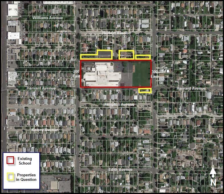
2 The following motion is provided in support of the recommendation: Based on the findings and analysis listed in the staff report and the testimony and plans presented, I move that the Planning Commission forward a positive recommendation to the City Council for the requested Master Plan Amendment PLNPCM , the Zoning Map Amendment PLNPCM and Alley Vacation PLNPCM I further move that the Planning Commission approve the Lot Consolidation PLNSUB with the condition that the approval is null and void if the earlier stated requests are not approved by the City Council. ATTACHMENTS: A. Vicinity Map B. Site Plan C. Building Elevations D. Site Photographs E. Additional applicant Information F. Existing Conditions G. Analysis of Standards H. Public Process and Comments I. Dept. Comments J. Motions PROJECT DESCRIPTION: 1. Proposal Details The Salt Lake School District has in the past 20 years worked to reconstruct the majority of their dated school buildings. Lincoln Elementary is the one of the last schools in the district to be updated. The applicant is seeking to build a new structure to the east of the existing structure facing 300 East on what is currently open space for the school. Once the new structure is constructed the original will be demolished and that area will be transformed into open space. The new school will be larger than the original and the school district has purchased 6 residential properties to the north of the school and one to the south in order to increase the size of the existing school site and provide additional open space. The proposal involves four separate requests: (1) Amend the Central Community Master Plan on the properties in question from Low Density Residential to Institutional. (2) Amend the zoning map designation for the subject parcels from R-1/5000 to PL. (3) Vacate a portion of an existing public alley adjacent to the existing school site. (4) Consolidate the properties in question with the larger existing school site. Zoning Map Amendment The Salt Lake City School District has purchased 7 properties that are adjacent to the existing Lincoln Elementary School. Three of these parcels have already been developed for additional parking: 1069 S. 200 E., 1064 S. Roberta Street and 1070 S. Roberta Street. The remaining parcels are vacant because the residential structures on those properties were recently demolished by the applicant. Currently all of the parcels in question are located in the R-1/5000 zoning district as shown in the map below. Schools are not a permitted use in the zone. The existing school site is located in the PL zoning district where schools are a

3 permitted use. The school is going to be rebuilt and expanded and the school district is seeking to expand the school site footprint onto the adjacent properties in question. Master Plan Amendment The Central Community Master Plan currently designates all of these properties as Low Density Residential and is designated as yellow in the map below. The master plan designates the school site as Institutional and is identified in blue in the map below. Because of the current designation, the master plan would not currently support the use of the properties as anything but low density residential. Alley Vacation The properties in question are a part of the platted South Carolina Subdivision. The portion of the alley that is proposed to be vacated is the south terminus of the existing alley between two properties owned by the applicant: 1071 S. R0berta St. and 1070 S. 300 E. If vacated the space would be consolidated with the larger school site, would be zoned as PL and designated on the master plan as Institutional.
 Demolitions and Jurisdiction.")
4 Lot Consolidation Lastly, in conjunction with the earlier discussed applications, the applicant has requested to consolidate all of their properties into one single parcel. KEY ISSUES: The key issue associated with this proposal are 1) Demolitions and Jurisdiction. The key issue is discussed further in the following paragraphs and was identified through the analysis of the project (Attachment F ) and public comments. Issue 1: Demolitions and Jurisdiction The state of Utah does not grant municipalities authority regarding a local school district s ability to construct buildings. The school district is exempt from obtaining any building or demolition permits and the school district will hire their own building inspectors to inspect the project as it moves forward. The project will have to meet all International Building and Fire Codes as well as meet federal requirements such as ADA requirements, but these will not be verified by the city. The construction of the new school has already begun on the site, and the applicant has already demolished all of the residential units on the properties in question. Although the preservation of the city s existing housing stock is a stated priority in community and city wide planning documents. The city could not have stopped the demolition of the residential structures. Because the school district is exempt from obtaining permits they are also exempt from the requirement to provide housing mitigation for the lost units. DISCUSSION: These 7 parcels of property are currently designated according to the master plan as Institutional and the zoning as R- 1/5000. A school is not a permitted use in the R-1/5000 zoning district. However, state law says that a municipality may not impose regulations on the location of a public school unless it is necessary to avoid unreasonable risks to
5 health or safety. The applicant is seeking to amend the master plan and the zoning to be consistent with the existing school site. The existing school serves the Liberty and portions of the Central City neighborhoods. This area of the city is a very diverse neighborhood with a student minority rate of 81% and a very high poverty rate with over 93% of students receiving free lunch. To help serve these populations the school also has a Community Learning Center and Clinic (CLC) which provides medical, dental and job instruction services. The existing CLC is not large enough to accommodate the needs of the community. In the newly rebuilt Lincoln Elementary they will be able to provide a much larger space and provide an increased number of services to the community. Construction has already begun on the site and all of the residential units have been demolished. Although the city encourages the preservation of the city s housing stock, the residential units have already been demolished. Staff believes that is important that the use of the property should be reflected in the master plan and the zoning designation of the property even if the city does not have the ability to enforce zoning or building standards related to the project. Further, there is support for the retention of neighborhood schools throughout the city in master planning documents. These policies will be discussed further in this report in the Existing Conditions section. NEXT STEPS: The Planning Commission s recommendations regarding the master plan amendment, zoning map amendment and the alley vacation will be forwarded to the City Council for their consideration as part of their final decision. The commission would make a final decision regarding the lot consolidation. If all petitions are ultimately approved, the applicant may proceed with the development of the project, subject to any conditions. If ultimately denied, the applicant would still be eligible to develop the properties as proposed except for the alley portion of the property, which is owned by the city. As discussed in the issues section, the school district is exempt from obtaining permits and other city approvals that are required for private developers.
6 ATTACHMENT A: Vicinity Map
7
8 ATTACHMENT B: Site Plan

9 '-0"H '-0"H 20'-0" '-0"H E1 GENERAL NOTES FOR SITE PLANS CONCRETE SIDEWALK, SEE DETAIL A3/A021. SIDEWALKS LOCATED IN THE RIGHT-OF-WAY SHALL BE CONSTRUCTED PER THE APWA STANDARDS SHOWN IN THE CIVIL DRAWINGS. NEW LANDSCAPED AREA WITH GRASS, PLANTING BED, ROCK MULCH, ETC. SEE LANDSCAPE DRAWINGS FOR THE EXTENT OF NEW WORK IN THIS AREA CHAIN LINK FENCE, BLACK VINYL COATED, ON CONCRETE MOW STRIP. SEE TYPICAL DETAIL B3/A021. FENCE HEIGHT SHALL BE AS NOTED ON PLAN. PROVIDE GATES AT THE LOCATIONS SHOWN. GATE HEIGHT SHALL MATCH FENCE HEIGHT '-0" A. NOT ALL TREES AND VEGETATION ARE SHOWN ON ARCHITECTURAL SITE PLANS. SEE LANDSCAPE PLANS FOR ALL NEW VEGETATION REQUIRED. B. SEE CIVIL DRAWINGS FOR CONTOUR LINES AND SPOT ELEVATIONS FOR CURBS, ASPHALT, LANDSCAPED AREAS, ETC. C. SLOPE SIDEWALKS 1/4" PER FOOT AWAY FROM BUILDING ENTRANCES, MIN. D. EXISTING CHAIN LINK FENCING WITHIN THE PROJECT AREA THAT IS NOT REPLACED(ALONG PROPERTY LINE) SHALL BE PROTECTED FROM DAMAGE DURING CONSTRUCTION. ANY DAMAGE THAT OCCURS WILL BE FIXED AT THE CONTRACTOR'S EXPENSE. E. USE ARCHITECTURAL RELEASE FORMS FOR A SMOOTH FINISH ON ALL CONCRETE RETAINING AND FOUNDATION WALLS THAT ARE VISIBLE OR EXPOSED. SPACE FORM TIES AND REVEALS EVENLY. F. ALL CONCRETE SIDEWALKS AND OTHER CONCRETE FLATWORK SHALL BE SEALED. SEE "PAINTING" SPECIFICATION IN THE PROJECT MANUAL. BOLLARD CONCRETE SIDEWALK OR PAVING WITH CONTROL JOINTS FENCE LINE (CHAIN LINK) FENCE LINE (ORNAMENTAL) PROPERTY LINE CONCRETE CURB OR CURB AND GUTTER SYSTEM, SEE CIVIL DETAILS. WHERE CONCRETE CURB IS ADJACENT TO SIDEWALK, POUR SIDEWALK & CURB AS ONE UNIT. CURB AND GUTTER LOCATED IN THE RIGHT OF WAY SHALL BE CONSTRUCTED PER THE APWA STANDARDS SHOWN IN THE CIVIL DRAWINGS. LIGHT POLE PAINT ON ASPHALT MARKINGS FOR PARKING STALLS, DIRECTIONAL ARROWS, TEXT, SYMBOLS, ETC., AS INDICATED. FIRE HYDRANT LANDSCAPE AREA - SEE LANDSCAPE DRAWINGS NJRA Architects, Inc S. College Drive, Suite104 Murray, Utah E GATE, 6'-0" HIGH X WIDTH SHOW, BLACK VINYL COATED CHAIN LINK CONSTRUCTION TO ADJACENT MATCH FENCE LEGEND FOR SITE PLANS TYP. KEYED NOTES LIGHT ASPHALT PAVING. SEE DETAIL C4/A E 18'-0" 5 2 4'-0" SELVAM RAJAVELU CATCH BASIN 6'-0" NORTH Enlarged Site Plan 1/16" = 1'-0" COMMUNITY GARDEN D D SHEET A011A SHEET A011B E1 A011 ROBERTA ST. 2 C C UP 1090 South Roberta St. Salt Lake City, UT B Lincoln Elementary School LINCOLN ELEMENTARY FFE: 4244' = 100'-0" NJRA Project # Salt Lake City School District B 300 EAST 200 EAST 2 UP 0 Bid Set Jan 5, Addendum #2 Jan 18, 2016 GRID GRID A A Site Plan Overall NORTH Site Plan - Overall 1" = 30'-0" A011
10 COMP. FILE 15024_Boundary PROJECT NO SHEET NO. 1 OF 1 RECORD OF SURVEY LINCOLN ELEMENTARY 1090 ROBERTA STREET, SLC, UTAH SITUATE IN THE SW 1/4 SEC 7, T1S,R1E, SLB&M BLOCK 21, 5 ACRE PLAT A, BIG FIELD SURVEY S.L.C. SCHOOL DISTRICT 995 BEARDSLEY PL COPYRIGHT ALL REPORTS, DESIGNS, FIELD DATA, FIELD NOTES, DRAWINGS, SPECIFICATIONS CALCULATIONS, ESTIMATES OR ANY REPRESENTATION CONTAINED HEREON ARE THE SOLE PROPERTY OF MERIDIAN UNLESS PREVIOUSLY ESTABLISHED SALT LAKE CITY, UTAH BY PRECEDENCE OR AGREEMENT DATE 12-JAN-2016 DRAWN SURVEYED TRW KWT CHECKED MWN NO. REVISIONS BY DATE
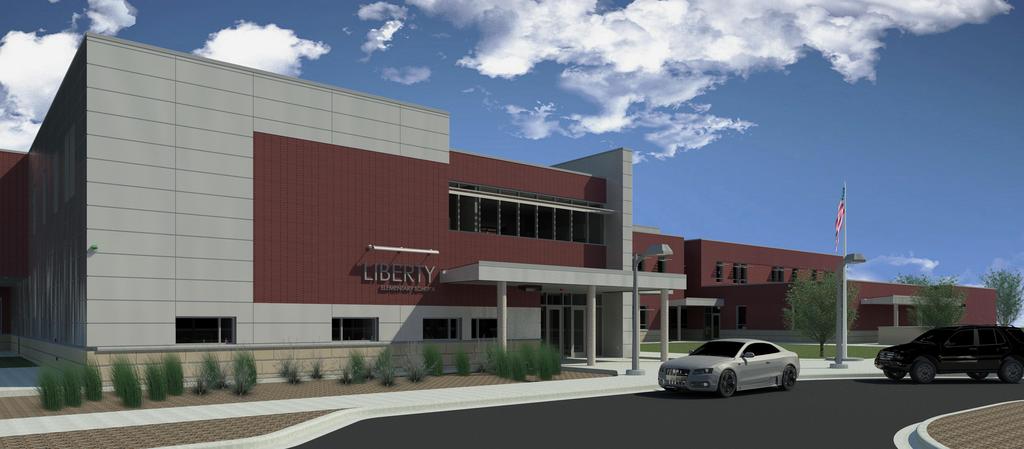
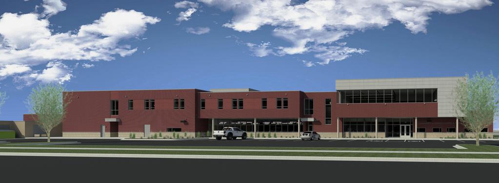
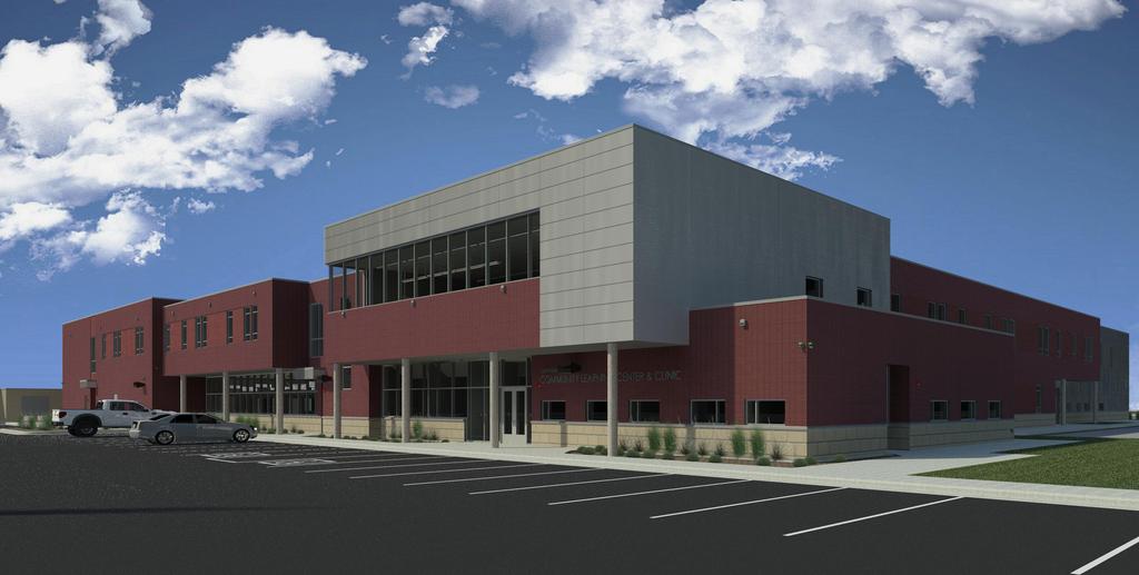
11 ATTACHMENT C: Building Elevations
12
13
14
15 ATTACHMENT D: Site Photographs

16 This photograph is looking east at a former residential property that has been developed as a parking lot along 200 East. The school can be seen on the right side of the photograph.

17 This is a photograph looking west at a former residential property that has been developed as a separate parking lot along Roberta Street.

18 This photograph is looking south from Roberta Street at the current entrance to Lincoln Elementary School.

19 This photograph is looking east on Roberta Street at 2 existing duplexes that are being prepared for demolition. The structures have been demolished since this photograph was taken.

20 This photograph is looking west from 300 East. One residential structure was demolished where the concrete piping is being stored. Construction on the school can be seen on the left side of the photograph.

21 This photograph is looking west from 300 East. Construction of the new school is clearly evident in this photograph.
22 This is a photograph looking west from 300 East. A single family residential structure was recently demolished in the fenced in area. This home was located south of the existing school and weass the only property in question located in that area.

23 This is a photograph looking south from Herbert Avenue down the existing alley. It is clear in this photograph that the alley is in use by current adjacent property owners.

24 This is a photograph looking north along the existing alley.
25 ATTACHMENT E: Additional Applicant Information
26
27
28
29
30
31
32
33
34 ATTACHMENT F: Existing Conditions Existing Conditions: The existing school site is approximately 4.8 acres in size. The site is bordered on the west by 200 East and the east by 300 East. The north and south sides of the site are bordered by low density residential neighborhoods. All surrounding properties are zoned R-1/5000. From the north the school site also has access from Roberta Street. The specific properties in question for this project include 3 properties on 200 East and the west side of Roberta Street that once had single-family dwellings but have since been converted into parking areas for the school. The remaining 4 parcels on 300 East and the east side of Roberta Street include 2 duplexes and 2 single family dwellings but these structures have been demolished and are currently vacant awaiting future school construction on those sites. SPECIFIC ZONING DISTRICT PURPOSE STATEMENTS 21A R-1/5000 Single Family Residential District The purpose of the R-1/5,000 single-family residential district is to provide for conventional single-family residential neighborhoods on lots not less than five thousand (5,000) square feet in size. This district is appropriate in areas of the city as identified in the applicable community master plan. Uses are intended to be compatible with the existing scale and intensity of the neighborhood. The standards for the district are intended to provide for safe and comfortable places to live and play, promote sustainable and compatible development patterns and to preserve the existing character of the neighborhood. 21A PL Public Lands District The purpose of the PL public lands district is to specifically delineate areas of public use and to control the potential redevelopment of public uses, lands and facilities. This district is appropriate in areas of the city where the applicable master plans support this type of land use. RELATED MASTER PLAN ITEMS The Central Community Master Plan views school as important elements to a community, stating on page 3 that they, bring balance and variety to the community. Further on page 12 the plan states, Schools are an important part of the community fabric and an essential component of viable and sustainable neighborhoods. Schools should be kept within neighborhoods as a community anchor and serve as a resource for residents of all ages. By allowing the school to rebuild and expand at its existing site it would help to achieve these stated goals. In contrast the plan also discusses potential negative impacts from institutional uses. The Central Community has many different institutional uses and although many of the stated negative impacts in the master plan were more related to higher education and medical uses all institutional uses do have an impact on the surrounding neighborhood. There is consistently a general concern about adequate parking and traffic in and around institutional uses. Currently the main entrance to the school is on Roberta Street with a secondary entrance on 200 East. The new proposed layout would have a separate parking facility on 300 East and a newly created turn around allowing for drop off traffic through Roberta Street and 200 East. These improvements should allow for an improved traffic pattern in and around the facility. It is also a stated policy in this plan and a general city policy to preserve the housing stock of all city neighborhoods. Preservation of the housing stock is an integral part of maintaining neighborhood character. Specifically the plan states, When existing institutional land uses outgrow their facilities, they often seek to acquire adjacent residential property to expand their facilities. Certain institutional land uses should not be allowed to expand beyond their existing properties unless the neighborhood and community support the institutional use expansion. The school district has already purchased all of the properties in question and has demolished all of the residential structures. It should also be noted that the community has generally vocalized support for the proposed expansion of the school site.
35 As was mentioned in the issues section of this report, the school district is exempt from obtaining building permits including demolition permits. Although it is important to retain as much housing as possible there are positive elements to the updated school. This school will have an expanded Community Learning Center which cannot currently accommodate the increased demand for their services. An enlarged school site would allow for that and will also provide for increased open space, which is a stated goal in the master plan. A new, improved school may also attract students from the surrounding neighborhood that currently attend other schools in the district rather than Lincoln Elementary. Plan Salt Lake also supports and promotes schools as an important neighborhood service and community gathering places. The plan states that these services should be within walking distance of all neighborhoods in the city which is defined as ¼ mile walking distance. There are no other public schools in the Liberty neighborhood. By allowing the expansion of Lincoln Elementary, the valuable community services they provide will be retained in the neighborhood.
36 ATTACHMENT G: ANALYSIS OF STANDARDS ZONING MAP AMENDMENTS 21A : A decision to amend the text of this title or the zoning map by general amendment is a matter committed to the legislative discretion of the city council and is not controlled by any one standard. In making a decision to amend the zoning map, the City Council should consider the following: Factor Finding Rationale 1. Whether a proposed map amendment is consistent with the purposes, goals, objectives, and policies of the city as stated through its various adopted planning documents; 2. Whether a proposed map amendment furthers the specific purpose statements of the zoning ordinance. As proposed the request meets the policies of the city as stated in the Central Community Master Plan and Plan Salt Lake. The proposed map amendme nt will further the purpose statement by ensuring that the school does not become a nonconfor ming use. As was discussed earlier in this report, the Central Community Master Plan and Plan Salt Lake recognize the importance of Institutional uses in the neighborhood with an emphasis on the retention of neighborhood elementary schools and the associated open space. However, the expansion of this school site has required the demolition of seven residential structures. The preservation of the city s housing stock is a community and city wide policy. The structures have already been demolished and as was earlier discussed, the school district is exempt from many of the city s ordinance and the requirement to obtain building or demolition permits. The school district is going to move forward with their project and staff believes that it s important that the use of the property should be reflected in the zoning of the property. The project has generally had public support as well which is indicated in the master plan as an important reason to allow the expansion of institutional uses. Staff believes that the support and services the school provides to the community is greater than the loss of the residential structures located on the properties in question. The purpose of the PL Public Lands zoning district is: The purpose of the PL public lands district is to specifically delineate areas of public use and to control the potential redevelopment of public uses, lands and facilities. This district is appropriate in areas of the city where the applicable master plans support this type of land use. A public school is an appropriate use in the zoning district and although the master plan does not support the loss of housing, it does support maintaining neighborhood schools. The requested amendment would allow the existing school to expand, provide additional community services and increase the amount of open space at the site. 3. The extent to which a proposed map amendment will affect adjacent properties; As proposed the design of the new school site should alleviate some existing negative impacts to adjacent properties. The school district is in need of a larger building and has acquired adjacent properties to allow for that. A school has existed at this site for decades and although a larger facility may have different or impacts to adjacent properties, the facility will be better designed and will function better than the existing facility. Because the school district has secured adjacent properties, it will allow for the school district to construct a larger building and to also preserve open space. The school district has stated that at least 50% of all of the properties in question will be landscaped rather than covered with structures. By acquiring these properties, it does provide an open space buffer to adjacent residential properties. The newly designed site will also improve traffic in and around the school which is a benefit to adjacent properties.
37 4. Whether a proposed map amendment is consistent with the purposes and provisions of any applicable overlay zoning districts which may impose additional standards 5. The adequacy of public facilities and services intended to serve the subject property, including, but not limited to, roadways, parks and recreational facilities, police and fire protection, schools, stormwater drainage systems, water supplies, and wastewater and refuse collection. NOTES: N/A Complies There are no applicable overlay zoning districts applied to the properties in question. The proposed subsequent development of the subject properties was reviewed by the various city departments tasked with administering public facilities and services, and no issues or concerns were raised. ALLEY VACATION : POLICY CONSIDERATIONS FOR CLOSURE, VACATION OR ABANDONMENT OF CITY OWNED ALLEYS: The city will not consider disposing of its interest in an alley, in whole or in part, unless it receives a petition in writing which demonstrates that the disposition satisfies at least one of the following policy considerations: Factor Finding Rationale A. Lack Of Use: The city's legal interest in the property appears of record or is reflected on an applicable plat; however, it is evident from an on site inspection that the alley does not physically exist or has been materially blocked in a way that renders it unusable as a public right of way; Does not comply The subject alley is part of a dedicated plat, approved by the city, that documents the city s interest in the alley. An on-site inspection confirms that the alley physically exists and is utilized by surrounding property owners. It has not been blocked or rendered otherwise unusable as a public right of way. B. Public Safety: The existence of the alley is substantially contributing to crime, unlawful activity, unsafe conditions, public health problems, or blight in the surrounding area; C. Urban Design: The continuation of the alley does not serve as a positive urban design element; or Does not comply Complies The subject alley has an open view from surrounding properties (not blocked by fences) and is utilized frequently during the day for access to adjacent properties. There is no evidence of crime, unsafe conditions, public health problems, or blight resulting from the alley. The applicant is requesting to vacate a small portion of the existing alley. The area proposed to be vacated is between two properties that the school district currently owns. It is feet in length and 16 feet in width which equates to approximately 869 square feet. The remaining portions of the alley would continue to be open for use. Alleys can be opportunities for providing access to the interior blocks for both vehicles and pedestrians. In this case, due to security risks, the school district is not utilizing this alley for access to their properties. Further, if the alley is not vacated the school district would develop the properties on either side of the alley leaving a small area of the alley that is not utilized and not developed. By
38 allowing the applicant to vacate that small portion of the alley, it will become a landscaped addition to the property. D. Community Purpose: The petitioners are proposing to restrict the general public from use of the alley in favor of a community use, such as a neighborhood play area or garden. (Ord , 2002) NOTES: Complies The proposal to vacate the alley would serve a greater community purpose over the current general public access. The portion of the alley to be vacated would be incorporated into open space surrounding the school site and would help to create a buffer between the use and the adjacent low density residential uses. LOT LINE ADJUSTMENT : STANDARDS OF REVIEW: Applications processed pursuant to this chapter shall meet the following standards. Factor Finding Rationale A. The proposed lot line adjustment(s) comply with all applicable zoning requirements, or reduce the amount of noncompliance Complies If the zoning map amendment is approved changing the zoning on the properties in questions from R-1/5000 to PL, the property will be compliant with all zoning requirements. B. Not yield two (2) principal buildings on one lot, unless permitted in the zoning district or by an approved planned development. Complies All of the residential structures on the properties in question have been demolished. The only remaining building on the property will be the actual school structure. C. Not affect any street right of way. Complies The proposed lot line adjustment would not affect any street right of way. D. Not create any new lots. (Ord. 7-14, 2014) Complies The proposed lot line adjustment would combine the 7 properties in question with the existing school site creating one large lot. NOTES:
39 ATTACHMENT H: Public Process and Comments Public Notice, Meetings, Comments The following is a list of public meetings that have been held, and other public input opportunities, related to the proposed project: Notice of the public hearing for the proposal included: Public hearing notice mailed on April 18, Public hearing notice posted on April 18, Public notice posted on City and State websites and Planning Division list serve: April 18, Public Comments The properties in question are located in an area of the city where two community council s boundaries overlap one another. The Liberty Wells and the Central City Community Councils were both contacted to inform them that because of the overlap the project would be placed on the agenda for the Planning Division monthly open house. There were several in attendance and most questions were related to the design of the proposed structure and the layout of the site. One resident in attendance expressed concerns with the loss of residential units that were required for the expansion of the school site and the fact that the school district is not required to provide housing mitigation for the loss in housing. Staff communicated with both community council chairs and neither expressed any concerns regarding the proposed expansion of the Lincoln Elementary School site.
40 ATTACHMENT I: Department Comments CITY DEPARTMENT COMMENTS Public Utilities (Jason Draper): No comments. Engineering (Scott Weiler): No objections. Transportation (Michael Barry): No comments. Zoning (Gregory Mikolash): No comments or objections. Fire (Ed Itchon): No comments or objections.
41 ATTACHMENT J: Motions Potential Motions Not Consistent with Staff Recommendation: Based on the findings and analysis listed in the staff report and the testimony and plans presented, I move that the Planning Commission not forward a positive recommendation for the requested Lincoln School Master Plan Amendment PLNPCM , Zoning Map Amendment PLNPCM , Alley Vacation PLNPCM and deny the requested Lot Consolidation PLNSUB The Planning Commission shall make findings on the zoning map amendment standards and specifically state which standard or standards are not being complied with, and; shall make findings on which factors the alley vacation and lot consolidation requests did not satisfy.
Staff Report PLANNING DIVISION COMMUNITY & ECONOMIC DEVELOPMENT. Alley Closure
 Staff Report PLANNING DIVISION COMMUNITY & ECONOMIC DEVELOPMENT To: From: Salt Lake City Planning Commission Doug Dansie, 801-535-6182, doug.dansie@slcgov.com Date: March 23, 2016 Re: PLNPCM2015-00941
Master Plan, Zoning Amendment and Preliminary Subdivision
 Staff Report PLANNING DIVISION COMMUNITY & ECONOMIC DEVELOPMENT To: From: Salt Lake City Planning Commission Doug Dansie, 801-535-6182, doug.dansie@slcgov.com Date: September 9, 2015 Re: PLNPCM2014-00254/00253
PLANNING COMMISSION STAFF REPORT. Merrimac PLNSUB Planned Development 38 West Merrimac November 9, Request. Staff Recommendation
 PLANNING COMMISSION STAFF REPORT Merrimac PLNSUB2011-00374 Planned Development 38 West Merrimac November 9, 2011 Planning and Zoning Division Department of Community and Economic Development Applicant:
PLANNING COMMISSION STAFF REPORT
 PLANNING COMMISSION STAFF REPORT ZONING MAP AMENDMENT PLNPCM2011-00091- Zoning Map Amendment PLNSUB2011-00090 Subdivision Amendment Approximately 700 North Columbus Court August 10, 2011 Planning and Zoning
PLNSUB Meridian Commerce Center Subdivision Amendment & PLNPCM Meridian Commerce Center Street Closure
 Staff Report PLANNING DIVISION COMMUNITY & ECONOMIC DEVELOPMENT To: From: Salt Lake City Planning Commission Daniel Echeverria, 801-535-7165, daniel.echeverria@slcgov.com Date: September 4, 2014 Re: PLNSUB2014-000469
Industrial Road Cross Dock Subdivision Minor Subdivision Preliminary Plat PLNSUB South Industrial Road Hearing date: May 9, 2013
 ADMINISTRATIVE HEARING STAFF REPORT Industrial Road Cross Dock Subdivision Minor Subdivision Preliminary Plat PLNSUB2013-00158 1900 South Industrial Road Hearing date: May 9, 2013 Applicant: Corbin Bennion
PLANNING DIVISION COMMUNITY & ECONOMIC DEVELOPMENT. To: Salt Lake City Planning Commission. PLNPCM John Glenn Road Zoning Map Amendments
 Staff Report PLANNING DIVISION COMMUNITY & ECONOMIC DEVELOPMENT To: Salt Lake City Planning Commission From: John Anderson, 801-535-7214, john.anderson@slcgov.com Date: March 22, 2017 Re: PLNPCM2017-00063
Request. Recommendation. Recommended Motion. Planning Division Department of Community and Economic Development
 PLANNING COMMISSION STAFF REPORT Legislative Item 900 South 900 East Rezone Zoning Map Amendment PLNPCM2010-00360 700 East 900 East, 700 South 900 South December 12, 2012 Applicant: City Council Luke Garrott
PLNPCM : Attached Garage Regulations for Residential Districts ZONING TEXT AMENDMENT
 Staff Report PLANNING DIVISION COMMUNITY & ECONOMIC DEVELOPMENT To: From: Salt Lake City Planning Commission Daniel Echeverria (801) 535-7165 or daniel.echeverria@slcgov.com Date: September 3, 2015 Re:
DATE: February 28, Marilynn Lewis, Principal Planner
 DATE: February 28, 2007 TO: FROM: RE: Salt Lake City Planning Commission Marilynn Lewis, Principal Planner Planning Commission Hearing for Petition 400-06-41 Zoning Map Amendment to Rezone 6 Properties,
RIVERDALE CITY PLANNING COMMISSION APPLICATION FOR RESIDENTIAL SUBDIVISION SITE PLAN APPROVAL
 Community Development 4600 So. Weber River Drive Riverdale, Utah 84405 RIVERDALE CITY PLANNING COMMISSION APPLICATION FOR RESIDENTIAL SUBDIVISION SITE PLAN APPROVAL CASE NO: DATE SUBMITTED: APPLICANT S
Business Park District Zoning Text Amendment (PLNPCM ) ZONING TEXT AMENDMENT
 ZONING TEXT AMENDMENT") Staff Report PLANNING DIVISION COMMUNITY & ECONOMIC DEVELOPMENT To: Salt Lake City Planning Commission From: Maryann Pickering, Principal Planner (801) 535-7660 Date: June 10, 2015 Re: Business Park District
Staff Report PLANNING DIVISION COMMUNITY & ECONOMIC DEVELOPMENT To: Salt Lake City Planning Commission From: Maryann Pickering, Principal Planner (801) 535-7660 Date: June 10, 2015 Re: Business Park District
Planning Division Department of Community & Economic Development. Applicant: Volunteers of America: Kathy Bray
 Planning Commission Staff Report Volunteers of America Large Group Home Supportive Housing for Young Men Conditional Use PLNPCM2011-00485 556 South 500 East Hearing date: October 26, 2011 Planning Division
Staff Report. Conditional Use. Salt Lake City Planning Commission
 Staff Report PLANNING DIVISION COMMUNITY & ECONOMIC DEVELOPMENT To: From: Salt Lake City Planning Commission Maryann Pickering, AICP, Principal Planner (801) 535-7660 maryann.pickering@slcgov.com Date:
ADMINISTRATIVE HEARING STAFF REPORT Country Club Acres Second Amended Subdivision Amendment PLNSUB E Parkway Avenue December 12, 2013
 ADMINISTRATIVE HEARING STAFF REPORT Country Club Acres Second Amended Subdivision Amendment PLNSUB2013-00925 2167 E Parkway Avenue December 12, 2013 Planning Division Department of Community & Economic
ADMINISTRATIVE HEARING STAFF REPORT
 ADMINISTRATIVE HEARING STAFF REPORT Epic Brewing Center Subdivision Minor Subdivision Preliminary Plat PLNSUB2013-00846 825 S. State St., 834 and 836 S. Edison St. Hearing date: December 12, 2013 Applicant:
Staff Report. Street Vacation. Salt Lake City Planning Commission. Ashley Scarff, (801) or Date: April 10 th, 2019
 or Date: April 10 th, 2019") Staff Report PLANNING DIVISION DEPARTMENT of COMMUNITY & NEIGHBORHOODS To: From: Salt Lake City Planning Commission Ashley Scarff, (801) 535-7660 or ashley.scarff@slcgov.com Date: April 10 th, 2019 Re:
Staff Report PLANNING DIVISION DEPARTMENT of COMMUNITY & NEIGHBORHOODS To: From: Salt Lake City Planning Commission Ashley Scarff, (801) 535-7660 or ashley.scarff@slcgov.com Date: April 10 th, 2019 Re:
Surplus Property Exchange
 Staff Report PLANNING DIVISION COMMUNITY & ECONOMIC DEVELOPMENT To: From: Salt Lake City Planning Commission Chris Lee, 801-535-7706, christopher.lee@slcgov.com Date: February 18, 2016 Re: PLNPCM2016-00049,
CHAPTER 26 PLANNING AND ZONING ARTICLE VII. MOBILE HOMES AND RECREATIONAL VEHICLE (RV) PARKS. Recreational Vehicle (RV) Park Development Standards
 PARKS. Recreational Vehicle (RV) Park Development Standards") CHAPTER 26 PLANNING AND ZONING ARTICLE VII. MOBILE HOMES AND RECREATIONAL VEHICLE (RV) PARKS. Section 26-VII-1. Section 26-VII-2. Section 26-VII-3. Section 26-VII-4. Section 26-VII-5. Purpose Permitted
CHAPTER 26 PLANNING AND ZONING ARTICLE VII. MOBILE HOMES AND RECREATIONAL VEHICLE (RV) PARKS. Section 26-VII-1. Section 26-VII-2. Section 26-VII-3. Section 26-VII-4. Section 26-VII-5. Purpose Permitted
(if more than one, give square footage for each) ANNEXATION LOT LINE Adjustments PRE/FINAL PLAT SPECIAL USE PERMIT
 ANNEXATION LOT LINE Adjustments PRE/FINAL PLAT SPECIAL USE PERMIT") Planning Commission Application Building & development office 915 Third ST. Rawlins WY ph. 307-328-4599 fax. 307-328-4590 PROJECT REVIEW: GENERAL INFORMATION Project name: OFFICE USE ONLY Site address
Planning Commission Application Building & development office 915 Third ST. Rawlins WY ph. 307-328-4599 fax. 307-328-4590 PROJECT REVIEW: GENERAL INFORMATION Project name: OFFICE USE ONLY Site address
Taylor Lot Coverage Variance Petition No. PLNBOA North I Street Public Hearing: November 7, 2012
 APPEALS HEARING OFFICER STAFF REPORT Applicant: Mark Taylor, property owner Staff: Thomas Irvin (801) 535-7932 thomas.irvin@slcgov.com Tax ID: 09-32-159-006-0000 Current Zone: SR-1A Special Development
Accessory Dwelling Units (ADUs)
") Community Development Department Planning Division 14177 Frederick Street PO Box 8805 Moreno Valley, CA 92552-0805 (951) 413-3206 Fax (951) 413-3210 Accessory Dwelling Units (ADUs) Completed Project Application
Community Development Department Planning Division 14177 Frederick Street PO Box 8805 Moreno Valley, CA 92552-0805 (951) 413-3206 Fax (951) 413-3210 Accessory Dwelling Units (ADUs) Completed Project Application
PLANNING DIVISION DEPARTMENT OF COMMUNITY AND NEIGHBORHOODS. Conditional Use
 Staff Report PLANNING DIVISION DEPARTMENT OF COMMUNITY AND NEIGHBORHOODS To: From: Salt Lake City Planning Commission Maryann Pickering, Principal Planner (801) 535-7660 Date: July 27, 2016 Re: Church
David J. Gellner, AICP, Principal Planner; (801) ; Zoning Map Amendment
 ; Zoning Map Amendment") Staff Report PLANNING DIVISION DEPARTMENT of COMMUNITY and NEIGHBORHOODS To: From: Salt Lake City Planning Commission David J. Gellner, AICP, Principal Planner; (801) 535-6107; david.gellner@slcgov.com
Staff Report PLANNING DIVISION DEPARTMENT of COMMUNITY and NEIGHBORHOODS To: From: Salt Lake City Planning Commission David J. Gellner, AICP, Principal Planner; (801) 535-6107; david.gellner@slcgov.com
Preliminary Subdivision Application (Minor) (Three (3) lots or less)
 (Three (3) lots or less)") Gunnison City Offices www.gunnisoncity.org 38 West Center Gunnison, Utah 84634 (435) 528 7969 Date of Application: Preliminary Subdivision Application (Minor) (Three (3) lots or less) APPLICANT INFORMATION
Gunnison City Offices www.gunnisoncity.org 38 West Center Gunnison, Utah 84634 (435) 528 7969 Date of Application: Preliminary Subdivision Application (Minor) (Three (3) lots or less) APPLICANT INFORMATION
PLANNING COMMISSION STAFF REPORT
 PLANNING COMMISSION STAFF REPORT AMENDMENTS TO CHAPTER 21A.40.050: 5 Foot Maximum Rear Setback for Accessory Structures Case # 4 April 2011 Planning and Zoning Division Department of Community and Economic
PLANNING COMMISSION STAFF REPORT
 PLANNING COMMISSION STAFF REPORT West Capitol Hill Amendments PLNPCM2012-00462- Master Plan Amendments PLNPCM2012-00463- Zoning Map Amendments PLNPCM2012-00464- MU Mixed Use District Text Amendment Meeting
Staff Report PLANNED DEVELOPMENT. Salt Lake City Planning Commission. From: Lauren Parisi, Associate Planner; Date: December 14, 2016
 Staff Report PLANNING DIVISION COMMUNITY & NEIGHBORHOODS To: Salt Lake City Planning Commission From: Lauren Parisi, Associate Planner; 801-535-7932 Date: December 14, 2016 Re: 1611 South 1600 East PLANNED
MASTER SUBDIVISION FINAL PLAT APPLICATION Town of Apex, North Carolina
 MASTER SUBDIVISION FINAL PLAT APPLICATION Town of Apex, North Carolina This document is a public record under the North Carolina Public Records Act and may be published to the Town s website or disclosed
ARTICLE VII. NONCONFORMITIES. Section 700. Purpose.
 ARTICLE VII. NONCONFORMITIES. Section 700. Purpose. The purpose of this chapter is to regulate and limit the development and continued existence of legal uses, structures, lots, and signs established either
Preliminary Subdivision Application (Major) (Four (4) lots or more)
 (Four (4) lots or more)") Gunnison City Offices www.gunnisoncity.org 38 West Center Gunnison, Utah 84634 (435) 528 7969 Date of Application: Preliminary Subdivision Application (Major) (Four (4) lots or more) APPLICANT INFORMATION
Gunnison City Offices www.gunnisoncity.org 38 West Center Gunnison, Utah 84634 (435) 528 7969 Date of Application: Preliminary Subdivision Application (Major) (Four (4) lots or more) APPLICANT INFORMATION
Hearing date: January 8, 2014
 Planning Commission Staff Report Administrative Item LIBERTY PARK PLACE MIXED USE PROJECT Planned Development PLNSUB2013-00587 Preliminary Condominium Plat PLNSUB2013-00589 1321 South 500 East Hearing
MINOR SUBDIVISION FINAL PLAT APPLICATION Town of Apex, North Carolina
 MINOR SUBDIVISION FINAL PLAT APPLICATION Town of Apex, North Carolina This document is a public record under the North Carolina Public Records Act and may be published on the Town s website or disclosed
STAFF REPORT Administrative Subdivision Hearing West 150 South Street, Parcel # , and
 Petition Number: 490-06-24 STAFF REPORT Administrative Subdivision Hearing Project Name: Project Location: Project Type: Applicant: Planning Staff: Haight Industrial Subdivision 5550 West 150 South Street,
PLANNING COMMISSION STAFF REPORT
 PLANNING COMMISSION STAFF REPORT West Capitol Hill Zoning Map Amendment Petition No. PLNPCM2011-00665 Located approximately at 548 W 300 North Street, 543 W 400 North Street, and 375 N 500 West Street
Short Title: Performance Guarantees/Subdivision Streets. (Public) April 28, 2016
 April 28, 2016") GENERAL ASSEMBLY OF NORTH CAROLINA SESSION S SENATE BILL Transportation Committee Substitute Adopted // House Committee Substitute Favorable // Fourth Edition Engrossed // Short Title: Performance Guarantees/Subdivision
GENERAL ASSEMBLY OF NORTH CAROLINA SESSION S SENATE BILL Transportation Committee Substitute Adopted // House Committee Substitute Favorable // Fourth Edition Engrossed // Short Title: Performance Guarantees/Subdivision
CITY PLAN COMMISSION STAFF REPORT
 CITY PLAN COMMISSION STAFF REPORT SUBJECT: Request for a Change of Zoning and Preliminary Development Plan FROM: Mara Perry, Director of Planning & Development MEETING DATE: November 6, 2017 PETITION:
THE REDEVELOPMENT PLAN
 PAGE 37 THE REDEVELOPMENT PLAN FUTURE LAND USE The Silver Terrace Redevelopment Area is currently designated as Redevelopment Area #4 on the City of Delray Beach Future Land Use Map (FLUM). This designation
Planning and Zoning Division Department of Community Development. Applicant: Ivory Towns LLC
 ADMINISTRATIVE HEARING STAFF REPORT Trolley Place Condominiums New Preliminary Condominium 480-08-08 located at approximately 540 South Denver Street July 7, 2008 Planning and Zoning Division Department
ZONING AMENDMENT, SUBDIVISION & SIDEWALK WAIVER REQUEST STAFF REPORT Date: November 16, 2006
 ZONING AMENDMENT, SUBDIVISION & SIDEWALK WAIVER REQUEST STAFF REPORT Date: November 16, 2006 NAME SUBDIVISION NAME Terhaar & Cronley Investment Partnership P & E Subdivision LOCATION 4210 and 4218 Halls
ADMINISTRATIVE HEARING STAFF REPORT
 ADMINISTRATIVE HEARING STAFF REPORT Providence Place Apartments Utility Box No. 2 Conditional Use Petition PLNPCM2011-00426 309 East 100 South September 22, 2011 Planning and Zoning Division Department
FINAL SITE PLAN PLAT APPLICATION Town of Apex, North Carolina
 FINAL SITE PLAN PLAT APPLICATION Town of Apex, North Carolina This document is a public record under the North Carolina Public Records Act and may be published on the Town s website or disclosed to third
ZONING AMENDMENT & SUBDIVISION STAFF REPORT Date: November 3, 2016
 ZONING AMENDMENT & SUBDIVISION STAFF REPORT Date: November 3, 2016 APPLICANT NAME SUBDIVISION NAME David Shumer 5955 Airport Subdivision CITY COUNCIL DISTRICT District 6 5955 Airport Boulevard, 754 Linlen
Planning Division Department of Community & Economic Development. Applicant: Peter and Sandra Clark
 Planning Commission Staff Report Peter and Sandra Clark Special Exception-Unit Legalization Special Exception PLNPCM2013-00336 2551 S Highland Drive Public Hearing: September 25, 2013 Planning Division
SECTION 7000 LAND DEVELOPMENT REQUIREMENTS
 SECTION 7000 LAND DEVELOPMENT REQUIREMENTS 7000 LAND DEVELOPMENT REQUIREMENTS... 1 7001 LEGISLATIVE AUTHORITY... 1 7001.1 LAND DEVELOPMENT... 1 7001.1.1 Title 40, Idaho Code... 1 7001.1.2 Idaho Code 40-1415
CHARLES CITY COUNTY SITE PLAN ORDINANCE. This Ordinance shall be known as the Charles City County Site Plan Ordinance.
 CHARLES CITY COUNTY SITE PLAN ORDINANCE Section 1. Title This Ordinance shall be known as the Charles City County Site Plan Ordinance. Section 2. Authority. This Ordinance is enacted pursuant to the authority
(a) Commercial uses on Laurel Avenue, abutting the TRO District to the
 Commercial uses on Laurel Avenue, abutting the TRO District to the") 32X Zoning Code 150.36 TRANSITIONAL RESIDENTIAL OVERLAY DISTRICT. (A) Intent and purpose. (1) It is the intent of the Transitional Residential Overlay District (hereinafter referred to as the "TRO District")
32X Zoning Code 150.36 TRANSITIONAL RESIDENTIAL OVERLAY DISTRICT. (A) Intent and purpose. (1) It is the intent of the Transitional Residential Overlay District (hereinafter referred to as the "TRO District")
PLANNED UNIT DEVELOPMENT (PUD) AREA PLAN/REZONING REVIEW PROCEDURE
 AREA PLAN/REZONING REVIEW PROCEDURE") PLANNED UNIT DEVELOPMENT (PUD) AREA PLAN/REZONING REVIEW PROCEDURE Professional inquiries will be made to our Township Planning Consultant, Township Engineer, and Township Attorney to get their opinions
PLANNED UNIT DEVELOPMENT (PUD) AREA PLAN/REZONING REVIEW PROCEDURE Professional inquiries will be made to our Township Planning Consultant, Township Engineer, and Township Attorney to get their opinions
CHAPTER 18 SITE CONDOMINIUM PROJECTS
 15.1800 CHAPTER 18 SITE CONDOMINIUM PROJECTS 15.1801 SECTION 18.01 PURPOSE AND SCOPE GRAND HAVEN CHARTER TOWNSHIP Site condominium projects are condominium developments in which each condominium unit consists
LABEL PLEASE NOTE: ALL APPLICATIONS AND SITE PLANS MUST BE COMPLETED IN BLACK OR BLUE INK ONLY Intake by:
 STAFF USE ONLY Thurston County Resource Stewardship 2000 Lakeridge Dr. S.W. Olympia, WA 98502 (360)786-5490 / (360)754-2939 (Fax) TDD Line (360) 754-2933 Email: permit@co.thurston.wa.us Supplemental Application
PLANNED UNIT DEVELOPMENT & SUBDIVISION STAFF REPORT Date: November 17, 2016
 PLANNED UNIT DEVELOPMENT & SUBDIVISION STAFF REPORT Date: November 17, 2016 DEVELOPMENT NAME SUBDIVISION NAME LOCATION Autonation Ford of Mobile Autonation Ford of Mobile Subdivision 901, 909, and 925
Guide to Minor Developments
 Guide to Minor Developments Introduction The Douglas County (DCD) is committed to providing open, transparent application processes to the public. This Guide is provided to assist anyone interested in
PLANNING COMMISSION STAFF REPORT SURROUNDING LAND USES. Light Industrial, Office, UDOT Right of Way (Interstate- 15)
") PLANNING COMMISSION STAFF REPORT MEETING DATE: March 21, 2019 PROJECT NUMBER: S-18-014 REQUEST: Final Plat approval for a single lot subdivision ADDRESS: 3535 South 500 West 7 Parcels: 15-36-127-021-0000,
PLANNING COMMISSION STAFF REPORT MEETING DATE: March 21, 2019 PROJECT NUMBER: S-18-014 REQUEST: Final Plat approval for a single lot subdivision ADDRESS: 3535 South 500 West 7 Parcels: 15-36-127-021-0000,
Condominium Unit Requirements.
 ARTICLE 19 CONDOMINIUM REGULATIONS Section 19.01 Purpose. The purpose of this Article is to regulate projects that divide real property under a contractual arrangement known as a condominium. New and conversion
PLANNING COMMISSION STAFF REPORT. QUEST ASSISTED LIVING CONDITIONAL USE PLNPCM West 800 North Hearing date: October 14, 2009
 PLANNING COMMISSION STAFF REPORT QUEST ASSISTED LIVING CONDITIONAL USE PLNPCM2009-00971 1820 West 800 North Hearing date: October 14, 2009 Planning Division Department of Community & Economic Development
SECTION SITE SURVEYS
 PART 1 - GENERAL 1.1 DESCRIPTION SECTION 02 21 00 SPEC WRITER NOTES: 1. Use this section only for NCA projects. 2. Delete between //---// if not applicable to project. Also delete any other item or paragraph
COMMERCIAL SITE PLAN & CONDITIONAL USE PERMIT REVIEW PROCESS & CHECKLIST
 Community Development 110 South Main Street Springville, UT 84663 COMMERCIAL SITE PLAN & CONDITIONAL USE PERMIT REVIEW PROCESS & CHECKLIST 801.491.7861 www.springville.org Prior to the issuance of a building
MIDWAY CITY Planning Office 75 North 100 West Phone: x105 Midway, Utah Fax:
 MIDWAY CITY Planning Office 75 North 100 West Phone: 435-654-3223 x105 Midway, Utah 84049 Fax: 435-654-2830 mhenke@midwaycityut.org Preliminary/ Final Application for Small Scale Subdivision Application
May 21, ACHD Board of Commissioners Stacey Yarrington, Planner II DRH /DRH
 Development Services Department May 21, 2013 TO: FROM: SUBJECT: ACHD Board of Commissioners Stacey Yarrington, Planner II DRH13-00106/DRH13-00108 Executive Summary: This is a design review application
ARTICLE 24 SITE PLAN REVIEW
 ARTICLE 24 SITE PLAN REVIEW 24.1 PURPOSE: The intent of these Ordinance provisions is to provide for consultation and cooperation between the land developer and the Township Planning Commission in order
Approval of a conditional use to allow construction of a rehabilitation hospital at 5115 N. Biltmore Lane in the American Center.
 Department of Planning & Community & Economic Development Planning Division Katherine Cornwell, Director Madison Municipal Building, Suite LL-100 215 Martin Luther King, Jr. Boulevard P.O. Box 2985 Madison,
CHAPTER 32 SUBDIVISIONS SECTION TITLE PAGE NO.
 Page 1 of 46 CHAPTER 32 SUBDIVISIONS SECTION TITLE PAGE NO. SECTION 32-1 Purpose of Ordinance 3 SECTION 32-2 Definitions 3 SECTION 32-3 Staff Sketch Review 4 SECTION 32-4 Subdivision and PUD Plats Required
ADMINISTRATIVE HEARING STAFF REPORT
 ADMINISTRATIVE HEARING STAFF REPORT Nin Tech West II Subdivision Amendment PLNSUB2013-00980 1515 & 1555 South Gramercy Road February 13, 2014 Planning Division Department of Community & Economic Development
WRIGHT TOWNSHIP Ottawa County 1565 Jackson Street, P.O. Box 255, Marne, Michigan 49435
 WRIGHT TOWNSHIP Ottawa County 1565 Jackson Street, P.O. Box 255, Marne, Michigan 49435 SPECIAL USE PERMIT APPLICATION _ Instructions For an application to be considered complete, ALL information must be
CONDITIONAL USE PERMIT (CUP)
") CONDITIONAL USE PERMIT (CUP) LAND DEVELOPMENT APPLICATION FORM DEPARTMENT OF PLANNING 300 East Main Street, Sun Prairie, WI 53590-2227 (608)825-1107 FAX (608)825-1194 Applications will not be processed
CONDITIONAL USE PERMIT (CUP) LAND DEVELOPMENT APPLICATION FORM DEPARTMENT OF PLANNING 300 East Main Street, Sun Prairie, WI 53590-2227 (608)825-1107 FAX (608)825-1194 Applications will not be processed
WOODLAND AREA GENERAL PLAN URBAN DEVELOPMENT POLICY
 APPENDIX A WOODLAND AREA GENERAL PLAN URBAN DEVELOPMENT POLICY The following text indicates proposed amendments to the Woodland Area General Plan Urban Development Policy currently adopted and included
PLANNING COMMISSION STAFF REPORT
 PLANNING COMMISSION STAFF REPORT First Unitarian Church Conditional Use & Subdivision PLNPCM2011-00211 & PLNSUB2011-00212 569 South 1300 East Public Hearing: August 10, 2011 Planning Division Department
APPLICATION PROCEDURE
 ANTRIM PLANNING BOARD P. O. Box 517 Antrim, New Hampshire 03440 Phone: 603-588-6785 FAX: 603-588-2969 APPLICATION FORM AND CHECKLIST FOR MINOR OR MAJOR SITE PLAN REVIEW File Date Received By APPLICATION
PLANNING DIVISION COMMUNITY & NEIGHBORHOODS. Conditional Use
 Staff Report PLANNING DIVISION COMMUNITY & NEIGHBORHOODS To: Salt Lake City Administrative Hearing Officer From: John Anderson, 801-535-7214 Date: March 22, 2018 Re: PLNPCM2018-00037 Conditional Use for
SUBDIVISION, PLANNED UNIT DEVELOPMENT, ZONING AMENDMENT, & SIDEWALK WAIVER STAFF REPORT Date: July 19, 2018
 SUBDIVISION, PLANNED UNIT DEVELOPMENT, ZONING AMENDMENT, & SIDEWALK WAIVER STAFF REPORT Date: July 19, 2018 NAME SUBDIVISION NAME LOCATION West Mobile Properties, LLC U.S. Machine Subdivision 556, 566,
SCHEDULE C. Application 1 The provisions of this Schedule apply to all zones except:
 SCHEDULE C OFF-STREET PARKING Application 1 The provisions of this Schedule apply to all zones except: (a) (b) (c) the extent, if any, to which the regulations applicable to a particular zone are in conflict
PRELIMINARY PLAT CHECK LIST
 PRELIMINARY PLAT CHECK LIST Name of Proposed Subdivision: The following items must be included with the initial submittal of a Preliminary Plat: Application, filled out completely Project Narrative Pre-application
REQUEST STAFF RECOMMENDATION. On April 26, 2012, Signature Books Inc., represented by Dave Richards, submitted petitions for the following amendments:
 PLANNING COMMISSION STAFF REPORT Signature Books Zoning Map Amendment and an Amendment to the North Temple Area Plan Petitions PLNPCM2012-00254 PLNPCM2012-00255 July 11, 2012 Planning Division Department
Chapter 9 - Non-Conformities CHAPTER 9 - INDEX
 CHAPTER 9 - INDEX 9-10: GENERAL... 3 9-20: SUBSTANDARD SIZE LOTS OR PARCELS... 3 9-20-10: GENERAL... 3 9-20-20: CUMULATING OF SUBSTANDARD SIZE LOTS OR PARCELS... 3 9-20-30: SEPARATION OF PLATTED SUBSTANDARD
Staff Report to the North Ogden Planning Commission
 Staff Report to the North Ogden Planning Commission SYNOPSIS / APPLICATION INFORMATION Application Request: Consideration and action on an administrative application for final approval for the Legacy North
Staff Report to the North Ogden City Council
 Staff Report to the North Ogden City Council SYNOPSIS / APPLICATION INFORMATION Application Request: Consideration and action on an administrative application to provide comments on the preliminary plan
2 April 9, 2014 Public Hearing
 2 April 9, 2014 Public Hearing APPLICANT (Street Closure): EBENEZER BAPTIST CHURCH APPLICANT & PROPERTY OWNER (Use Permit Modification): EBENEZER BAPTIST CHURCH STAFF PLANNER: Kevin Kemp REQUESTS: A. Street
Administrative Hearing Officer, Salt Lake City Planning Division. Conditional Use for the Salt Flats Brewery Club/Tasting Room (PLNPCM )
") Staff Report PLANNING DIVISION DEPARTMENT of COMMUNITY and NEIGHBORHOODS To: From: Administrative Hearing Officer, Salt Lake City Planning Division David J. Gellner, AICP, Principal Planner (801) 535-6107
Staff Report PLANNING DIVISION DEPARTMENT of COMMUNITY and NEIGHBORHOODS To: From: Administrative Hearing Officer, Salt Lake City Planning Division David J. Gellner, AICP, Principal Planner (801) 535-6107
FINAL PLAT APPLICATION
 FINAL PLAT APPLICATION (Page 1 of 3) LEGAL OWNER(s): NAME: STREET ADDRESS OWNER(s): CITY, STATE, ZIP CODE: PHONE NUMBER: BILLING ADDRESS: NAME OF ENGINEER/SURVEYOR: Engineer/Surveyor Address, Phone: PROPERTY
Vacating a Street, Right-of-Way or Easement
 Vacating a Street, Right-of-Way or Easement Application Packet Public Works Department New Development Division 175 East 200 North St. George, UT 84770 Office (435) 627-4120 Dear Applicant, This packet
CITY OF SARALAND FINAL SUBDIVISION PLAT REVIEW
 CITY OF SARALAND FINAL SUBDIVISION PLAT REVIEW Application Number: Date Plat Submitted: Name of Subdivision: Name of Owner: Owner Address: (Street or P.O. Box) Telephone #: (City) (State) (Zip) E-mail:
WRIGHT TOWNSHIP Ottawa County 1565 Jackson Street, P.O. Box 255, Marne, Michigan 49435
 WRIGHT TOWNSHIP Ottawa County 1565 Jackson Street, P.O. Box 255, Marne, Michigan 49435 SITE PLAN REVIEW APPLICATION _ Instructions For an application to be considered complete, ALL information must be
Bowie Marketplace Residential Detailed Site Plan Statement of Justification January 13, 2017 Revised February 2, 1017
 Bowie Marketplace Residential Detailed Site Plan Statement of Justification January 13, 2017 Revised February 2, 1017 Submitted on behalf of: BE Bowie LLC 5410 Edson Lane, Suite 220 Rockville, MD 20852
A GUIDE TO PROCEDURES FOR: SUBDIVISIONS & CONDOMINIUM CONVERSION
 A GUIDE TO PROCEDURES FOR: SUBDIVISIONS & CONDOMINIUM CONVERSION A GUIDE TO PROCEDURES FOR: SUBDIVISIONS (TENTATIVE MAPS) PURPOSE Definition: A subdivision is defined as the division of any improved or
CITY OF BIG BEAR LAKE
 CITY OF BIG BEAR LAKE (909) 866-5831 P.O. Box 10000 39707 BIG BEAR BOULEVARD BIG BEAR LAKE, CA 92315 DEVELOPMENT REVIEW APPLICATION FOR STAFF USE ONLY FILING DATE: RECEIVED BY: FILE #: FEES PAID: RECEIPT
ARTICLE 388. PD 388. Tenth Street Neighborhood
 ARTICLE 388. PD 388. Tenth Street Neighborhood SEC. 51P-388.101. LEGISLATIVE HISTORY. PD 388 was established by Ordinance No. 21850, passed by the Dallas City Council on October 13, 1993. Ordinance No.
Guide to Combined Preliminary and Final Plats
 Guide to Combined Preliminary and Final Plats Introduction The Douglas County is committed to providing open, transparent application processes to the public. This Guide is provided to assist anyone interested
Greg Mikolash, Development Review Supervisor ( ;
 Staff Report DEPARTMENT of COMMUNITY and NEIGHBORHOODS To: From: Salt Lake City Appeals Hearing Officer Greg Mikolash, Development Review Supervisor (801-535-6181; gregory.mikolash@slcgov.com) Date: October
Downtown Meridian Urban Renewal Area URBAN RENEWAL ELIGIBILITY REPORT. Prepared for The City of Meridian and The Meridian Development Corporation
 Downtown Meridian Urban Renewal Area URBAN RENEWAL ELIGIBILITY REPORT Prepared for The City of Meridian and The Meridian Development Corporation by McKibben + Cooper Architects June 19, 2002 Authorization
BEFORE THE HEARING EXAMINER FOR THURSTON COUNTY
 COUNTY COMMISSIONERS Cathy Wolfe District One Diane Oberquell District Two Robert N. Macleod District Three HEARING EXAMINER BEFORE THE HEARING EXAMINER FOR THURSTON COUNTY In the Matter of the Application
WAYNE COUNTY, UTAH SUBDIVISION ORDINANCE
 WAYNE COUNTY, UTAH SUBDIVISION ORDINANCE A LAND USE ORDINANCE OF WAYNE COUNTY As Adopted by the Wayne County Board of County Commissioners Effective January 01, 2011 Prepared by: PLANNING AND DEVELOPMENT
To provide for the review of the final engineering plans, the subdivision improvement agreement, public dedications, and other legal agreements.
 ARTICLE 5 FINAL PLAT 501 Intent DOUGLAS COUNTY SUBDIVISION RESOLUTION To provide for the review of the final engineering plans, the subdivision improvement agreement, public dedications, and other legal
GENERAL PLAN, DEVELOPMENT CODE AND ZONING MAP AMENDMENT APPLICATION INFORMATION SHEET
 GENERAL PLAN, DEVELOPMENT CODE AND ZONING MAP AMENDMENT APPLICATION INFORMATION SHEET GENERAL INFORMATION This information sheet explains how an application requesting an amendment to the Truckee General
CITY OF EAU CLAIRE, WISCONSIN. SPECIAL ASSESSMENT POLICY (Dated: November 8, 2016)
") CITY OF EAU CLAIRE, WISCONSIN SPECIAL ASSESSMENT POLICY (Dated: November 8, 2016) (Adopted by reference by Ordinance No. 7207 adopted November 8, 2016) PURPOSE The purpose of this Policy is to assure fair
CITY OF EAU CLAIRE, WISCONSIN SPECIAL ASSESSMENT POLICY (Dated: November 8, 2016) (Adopted by reference by Ordinance No. 7207 adopted November 8, 2016) PURPOSE The purpose of this Policy is to assure fair
ARTICLE 7: PLOT PLANS AND SITE PLAN REQUIREMENTS AND REVIEW
 ARTICLE 7: PLOT PLANS AND SITE PLAN REQUIREMENTS AND REVIEW Section 7.0 - Purpose The purpose of this article is to specify the documents and/or drawings required for a Site Plan Review or a Plot Plan
SUBJECT: Application for Planned Unit Development and Rezoning 1725 Winnetka Road
 TO: FROM: CHAIRMAN BILL VASELOPULOS AND MEMBERS OF THE PLAN & ZONING COMMISSION STEVE GUTIERREZ DIRECTOR OF COMMUNITY DEVELOPMENT MEETING DATE: September 5, 2017 SUBJECT: Application for Planned Unit Development
Right of Way Vacation
 City of Yakima Right of Way Vacation Application Packet City of Yakima, Planning Division 129 North 2 nd Street, 2 nd Floor, Yakima, WA 98901 Phone#: (509) 575-6183 Email: ask.planning@yakimawa.gov Check
SUBDIVISION APPLICATION
 SUBDIVISION APPLICATION Community Planning and Economic Development Development Services Division 250 South 4 th Street, Room 300 Minneapolis MN 55415-1316 612-673-3000 This application packet is used
13 NONCONFORMITIES [Revises Z-4]
![13 NONCONFORMITIES [Revises Z-4]](/thumbs/87/97238669.jpg "13 NONCONFORMITIES [Revises Z-4]") Dimensional Standards Building Design Standards Sidewalks Tree Protection & Landscaping Buffers & Screening Street Tree Planting Parking Lot Landscaping Outdoor Lighting Signs 13.1 PURPOSE AND APPLICABILITY
Dimensional Standards Building Design Standards Sidewalks Tree Protection & Landscaping Buffers & Screening Street Tree Planting Parking Lot Landscaping Outdoor Lighting Signs 13.1 PURPOSE AND APPLICABILITY
ARTICLE 900 PLAT AND PLAN REQUIREMENTS
 ARTICLE 900 PLAT AND PLAN REQUIREMENTS SEC. 900.1 ITEMS TO BE SHOWN ON PLAT OR PLAN General (1) Property lines of all property owners adjacent to the exterior boundaries of the project shall be located