ADEQ. G/ Chief ~62. OCT 1 2 :(\is; October 11,2005. Mr. David Barron Arkansas Infrastructure Inc Highway 16 East Shirley, AR 72453
|
|
|
- Logan Jenkins
- 5 years ago
- Views:
Transcription
1 ADEQ A R K A N S A S Department of Environmental Quality October 11,2005 Mr. David Barron Arkansas Infrastructure Inc Highway 16 East Shirley, AR Dear Mr. Barron: Please find enclosed pour copy of Open-Cut Mining Permit Number #0623-MN for the Arkansas Infrastructure Inc. mine site in Van Buren County, Arkansas. If you have any questions coi~cerning this matter, please contact me at (501) Sincerely, James F. Stephens, P. G. G/ Chief enclosure OCT 1 2 :(\is; ~62 SURFACE MINING AND RECLAMATION DIVISION 8001 NATIONAL DRIVE / POST OFFICE BOX 8913 / LllTLE ROCK, ARKANSAS / TELEPHONE / FAX w.adea.state.or.us

2
3 Open-Cut Mining Permit Application For Arkansas Infrastructure, Inc. Weaver Creek Mine Shirley, Arkansas March 2005 Arkansas Infrastructure, Inc. And Cenark Project Management Services, Inc.
4 Permit Application Checklist A. The below listed items are the minimum requirements for permit application submission: 1. Two signed and notarized permit application forms 2. Permit application fee 3. Proof of right to mine 4. Mining Plan 5. Reclamation Plan 6. Maps a) 7.5 min. topographic quadrangle vicinity map b) Site map rn c) Reclamation map 7. Bond determination 8. Bond instrument 9. Disclosure statement
5 MAIL TAX STATEMENT TO Ozark Title Services. Inc. Under the Npavirion of E. Lcon Nichobon. Attorney at Law Greers Fcrry. Arknras WARRANTY DEED!Doc# (Married Persons) THIS DEED made and entered intoon this th&h&day of fihfu.*",22003, by and between JOHN H. SIETSTRA and LINDA J. SIETSTRA, husband and wife, ; gin their own right and as spouse of the other, as GRANTOR, whether one or more, and CHARLES DAVID BARR~N and OPAL WONNE BARRON, husband and wife, as GRANTEE, whether one or mire, WITNESSETH: That said Grantor, for and in consideration of the sum of One Dollar ($1.00), cash in hand paid, and other good and valuable consideration, the receipt of all of which is hereby acknowledged, does hereby grant, bargain, sell and convey unto the Grantee, and unto the Grantee's heirs and assigns forever, the following described property lying and situated in VAN BUREN County, Arkansas, to-wit: PART OF THE SOUTH 112 OF THE SW 114 OF THE SE 114 OF SECTION 26, TOWNSHIP 12 NORTH, RANGE 13 WEST AND PART OF THE NW 114 OF THE NE 114 OF SECTION 35, TOWNSHIP 12 NORTH, RANGE 13 WEST, ORE PARTICULARLY DESCRlBED AS: BEGINNING AT THE NORTHEAST CORNER OF THE NW 114 NE 114, SECTION 35, TOWNSHIP 12 NORTH, RANGE 13 WEST, THENCE SOUTH 627 FEET, THENCE WEST 190 FEET APPROXIMATELY TO THE CENTER LINE OF WEAVER CREEK, THENCE SOUTHWEST AND UP THE CENTER OF WEAVER CREEK A DISTANCE OF FEET APPROXIMATELY TO THE EAST PROPERTY LINE OF KENNY LINN, THENCE NORTHWEST AND LEAVING SAID CREEK A DISTANCE OF APPROXIMATELY 974 FEET TO THE CENTER OF HIGHWAYS NUMBER 16 AND 9, THENCE NORTHEAST ALONG SAID HIGHWAY 1550 FEET TO A POINT ON THE EASTERN LINE OF THE SW 1/4 SE 1/4, SECTION 26, THENCE SOUTH FEET TO THE POINT OF BEGINNING, CONTAINING 12 ACRES, MORE OR LESS IN SECTION 26 AND ACRES, MORE OR LESS IN SECTION 35 AND CONTAINING IN THE AGGREGATE ACRES, MORE OR LESS.
6 -2- TO HAVE AND TO HOLD THE SAME, together with all tenements and improvements thereon and hereditaments and appurtenances thereunto belonging or in any wise appertainkg unto the said Grantee, and unto the Grantee's heirs and assigns forever. The Grantor, for the considerations aforesaid, does hereby release, relinquish and convey unto the Grantee, and unto the Grantee's heirs and assigns forever, any right, claim and possibility of dower, curtesy and homestead of Grantor in and to said real property. - ~rantbfd~iii h&b&=iagi a@ee thaf Gmor dl1 foreverwarrant d defend the-title to said real estate unto the Grantee, and unto the Grantee's heirs and assigns forever, against the lawhl claims and demands of all persons whomsoever. IN WITNESS WHEREOF, the Grantor has hereunto signed this Deed on the day and year first herein written. 4
7 CERTIP~TE OF F~ECORD h n zeo3isje Pa e if1 Dab 83/21/ :34:2i PN Fiied & Recorded it) -3- Official Records of STflTE OF flrkfflscis ACKNOWLEDGMENT STATE OF ARKANSAS COUNTY OF CLEBURNE -- BE IT REMEMBERED that on this day before me, the undersigned, a Notary Public within and for the County and State aforesaid, duly commissioned, qualified and acting, appeared the within named JOHN H. SIETSTRA and LINDA J. SIETSTRA, husband and wife, to me so known or identified, and to me stated and acknowledged that the foregoing Warranty Deed was executed for the considerations and purposes therein mentioned and contained and I hereby so certifl. IN WITNESS WHEREOF, I have hereunto set my hand and seal as such Notary Public on this REAL PROPERTY TRANSFER TAX AFFIDAVIT c been placed on this ~nstrument. /"
8 Ozark Title Services, lnc. Under the supervision of E. Leon Nicholson. Attorney at Law Grem Ferry. Arkansas WARRANTY DEED (Corporate) THIS DEED made and entered into on this the day of a - -,2002, by and between BIG BRANCH FARMS INC., a corporation, by and through its duly authorized officer(s), as GRANTOR, whether one or more, and CHARLES DAVID BARRON and OPAL YVONNE BARRON, husband and wife, as GRANTEE, whether one or more, TVJTTESSETH: That said Grantor, for and in consideration of the sum of One Dollar ($1.00), cash in hand paid, and other good and valuable consideration, the receipt of all of which is hereby acknowledged, does hereby grant, bargain, sell and convey unto the Grantee, and unto the Grantee's heirs and assigns forever, the following described property lying and situated in VAN BUREN County, Arkansas, to-wit: PART OF THE SOUTHEAST QUARTER OF THE SOUTHEAST QUARTER (PT. SE 114 SE 114), SECTION TWENTY-SIX (26), TOWNSHlP TWELVE (12) NORTH, RANGE THIRTEEN (13) WEST, VAN BUREN COUNTY, ARKANSAS, MORE PARTICULARLY DESCRIBED AS FOLLOWS: COMMENCING AT THE SOUTHEAST CORNER OF SECTION 26, T-12-N, R-13-W, THENCE N 89 DEGREES 26' 52" W FEET TO A SET IRON PIN AT THE POINT OF BEGINNING, THENCE N 00 DEGREES 1 1' 40" E FEET TO THE INTERSECTION OF A BRANCH-&WEAVER CREEK, THENCE ALONG THE CENTER OF THE AFORESAID BRANCH, RUN N 20 DEGREES 46' 19" W FEET TO A POINT, THENCE N 24 DEGREES 3 1' 24" W FEET TO A POINT, THENCE N 35 DEGREES 56' 24" W FEET TO A POINT WHERE THE BRANCH INTERSECTS THE SOUTH RIGHT OF WAY LINE OF HIGHWAY NUMBER 16, THENCE ALONG THE THE SOUTH RIGHT OF WAY LINE OF HIGHWAY 16, RUN S 43 DEGREES 1 8' 4 1 " W FEET TO A POINT, THENCE S 44 DEGREES 58' 47" W FEET TO A POINT, THENCE S 60 DEGREES 09' 37" W FEET TO A POINT, THENCE S 42 DEGREES 47' 10" W FEET TO A POINT, THENCE S 62 DEGREES 39' 58" W FEET TO A POINT, THENCE S 71 DEGREES 04' 26" W FEET TO A POINT, THENCE S 75 DEGREES 40' 15" W FEET TO A POINT, THENCE S 78 DEGREES 27' 26" W FEET TO A POINT, THENCE S 78 DEGREES 55' 50" W FEET TO A POINT, THENCE S 76 DEGREES 34' 44" W FEET TO A SET IRON PIN, THENCE ALONG THE WEST LINE OF THE SAID SE 114 SE 114, SECTION 26, RUN S 00 DEGREES 07' 46"
9 W FEET TO A SET IRON PIN, THENCE ALONG THE SOUTH LINE OF THE SAID SE 114 SE 1/4, SECTION 26, RUN S 89 DEGREES 26 52" E FEET TO A SET IRON PIN AT THE POINT OF BEGINNING CONTAINING ACRES, MORE OR LESS, ACCORDING TO THE DANNY L. ROBERSON SURVEY RECORDED IN SURVEY RECOm "G, PAGE 374. TO HAVE AND TO HOLD THE SAME, together with all tenements and improvements thereon and hereditaments - and appurtenances thereunto - belonging or in any wise appertaining, unto the said Grantee, and unto the Grantee's heirs and assigns forever. Grantor does hereby covenant and agree that Grantor will forever warrant and defend the title to said real estate unto the Grantee, and unto the Grantee's heirs and assigns forever, against the lafil claims and demands of all persons whomsoever. herein written. IN WITNESS WHEREOF, the Grantor has hereunto signed this Deed on the day and year first BIG BRANCH FARMS INC., GRANTOR,
10 ACKNOWLEDGMENT V w STATE OF ARKANSAS COUNTY OF CLEBURNE 4' BE IT REMEMBERED that on this day before me, the undersigned, a Notary Public within and for the domy and ~&eafodd, duly commissioned,qualified an-zaee-nma DANIEL J. GRIUOT and KAREN H. GRILLOT, the duly authorized officers of BIG BRANCH FARMS INC., a corporation, to me so known or identified, and to me stated and acknowledged that, acting in said corporate capacity, the foregoing Warranty Deed was executed for the considerations and purposes therein mentioned and contained and I hereby so certifl. IN WITNESS WHEREOF, I have hereunto set my hand and sea*. he [@7\dayof &.&.'L this REAL PROPERIY M S F mthe kgally correct pn this inshument /'
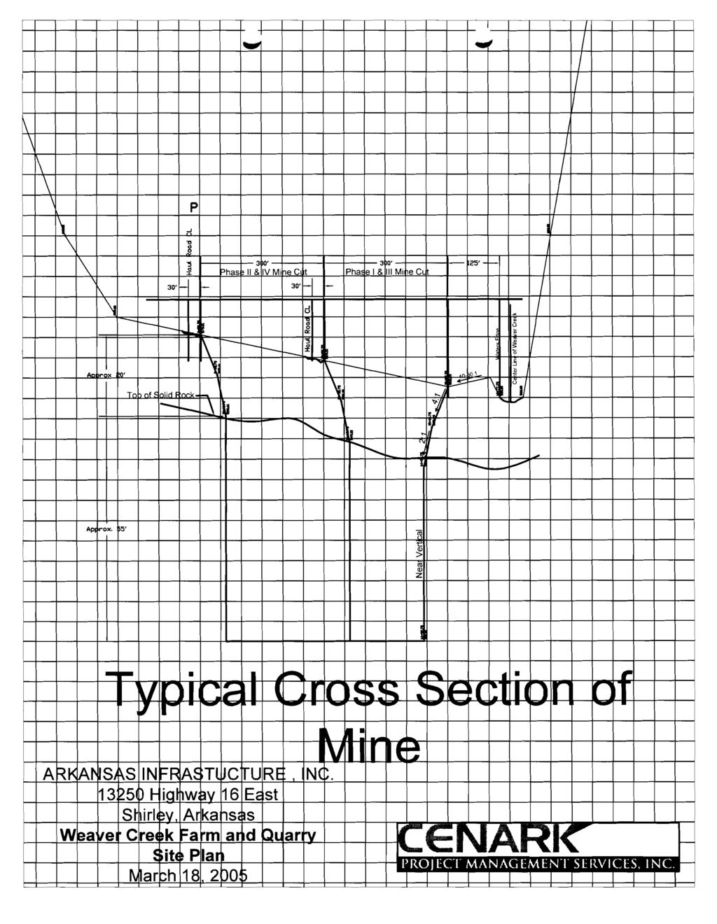
11 Arkansas Infrastructure, Inc. Weaver Creek Farm and Quarry Mining Plan Refer to the attached Weaver Creek Farm and Quarry Site Plan. The overall purpose of the mining operation is as follows: To construct an irrigation pond for an interim vegetable farming operation To sell mined material on the open market To provide reuse irrigation water for crop production To control storm and irrigation water run-off from the farming operation To ultimately convert the land area to scenic pond, fish habitat, and property enhancement feature. To achieve the above purposes, a mining operation is planned upon the land over several years. The mine will be operated by Arkansas Infrastructure, Inc., a licensed contracting company operating in Arkansas and surrounding areas. In addition to construction, Arkansas Infrastructure, Inc. is in the farming business and desires to improve the 50+ acre tract shown in the plan to an interim vegetable farm for the next few years. The overall plan is to farm portions of the acreage and mine a portion of the acreage simultaneously in such a way that both operations compliment each other. The mining pit will be opened in phases, with each phase creating or expanding the irrigation water storage area needed to support crop irrigation in the growing season. As the material is mined and exported from the site the pond area will increase, thus supporting the farm land production. At some point the optimal space will be provided for irrigation and farming. At this time the decision will be made as to continue emphasis on the farming operation or the mining operation. If mining has proven profitable the mine will be expanded and the farm operation diminished. If farming has proven to be more profitable the farm will continue and the mining will stop. In either case the land is being placed into its highest and best use. The following description of the mining plan assumes mining to be the highest and best use, therefore, this permit application is being sought to support this scenario. The plan will begin upon issuance of a mining permit and other permits that may be necessary for the overall operation. This is expected to happen in the spring of This is important to the 2005 farming operation, so mining can provide a means to process material away from the site to create the beginning irrigation pond. Once the mining is started the ultimate pond will be formed in phases over several years of operation. The material to be mined will consist of sand, gravel and quarry rock. A portion of the overburden sand and gravel will be sold and exported directly away from the site for use C Wro~ecrs\Arkansas Infrastructure lnc\mintng Perm~fs\Weaver Creek Open P1l\i-I9-2005_Mtnnng and Reclamation plan doc CEh4RK PROJECT MANAGEMENT SERVICE IUC

12 as imported fill to various local construction sites. The remaining overburden sand and gravel will be processed through a crushing and sizing plant into various marketable materials and exported from the site. The overburden covers hard rock that will be drilled and shot prior to overburden removal to a depth of approximately 50'. This material will be later processed into concrete aggregate, road base and other sized products. The operation will commence by setting up the plant in the location shown on the site plan. A combination of overburden mining for processing and borrow pit exporting will begin. This work will be staged in such a way as to construct a small initial irrigation reservoir to support the farming operation in The mining will begin in the area designated Area 1-Phase I at the southeast end and progress as shown toward the west. All mined material will be exported away from the site thus forming the ultimate pond structure. As time goes on and material is processed from the site the mining will be expanded to Area %-Phase 2 and so on as indicated on the site-plan. Assuming the mining operation continues and farming diminishes the mine operation will stop when all the material is removed from Areas 1 thru 4 by phases of operation. The remaining area where the plant was initially established will be mined as a borrow pit so the material will be removed down to solid rock to establish the final pond configuration. At that time the mine area will form the pond as shown on the Reclamation Plan and mine closure will be completed. The configuration of the site and mined areas will be as shown on the "Site Plan" and the "Typical Cross Section of Mine" detail. The slope along Weaver Creek is such that a 40 to 50: 1 slope exists from the creek's existing bank location to the beginning of the mine pit edge. The first 10' depth around the mine perimeter will be cut to a 4: 1 slope. The next 10' of depth or until solid rock is encountered will be 2: 1. The cut in solid rock will be near vertical or stepped as needed for stability. While not initially, the property will eventually be fenced with light barbed wire as a barrier to discourage unauthorized ingress onto the property along Highway 16 and along the east and west perimeters. Gates will be maintained at two entrances, one primary to the plant and one secondary for direct overburden removal by trucks. Warning signs will be placed at the entrances and along the Highway 16 side of the property. Contact is underway with the Mine Safety and Health Administration to implement any safety requirements necessary. Once the crushing plant is set up, construction of the sediment ponds shown on the site plan and the installation of the circulation piping and wash water pump system will begin. The initial mining will be for exported fill material used for fill at local construction sites and for start-up of the crushing plant. Topsoil will be removed where topsoil exists prior to mining and stockpiled in the location shown on the site plan. Approximately 3500 BCY of topsoil will be stockpiled over the course of mining for replacement during reclamation. Approximately 4 acres of C-\Projects\Arkansas Infrastructure Inc\Mining Permits\Weaver Creek Open Pil\ Mining and Reclamation plan doc CENARK PROJECT MANAGEMENT SERVICE. Ih'C
13 pond perimeter will be reclaimed and re-vegetated plus any other remaining disturbed areas. Topsoil stockpiles will be temporarily seeded with Bermuda grass as needed to control erosion. Haul roads will be constructed as shown on the site plan to a width of 20' with side ditching to control drainage. Drainage will be controlled over the entire site by means of ditches, culvert installations, and berms. Crusher wash water will be controlled within the plant area, accumulated and pumped to the sedimentation ponds and returned to the plant for reuse. Farm irrigation runoff will be directed back to the irrigation ponds created by the mining operation. No water from the site will be allowed into Weaver Creek or the unnamed drainage branch to the east of the permit site and property boundary. Weaver Creek forms the permit boundary to the south. Arkansas Infrastructure is currently obtaining Section 404 Permits from the United States Army Corps of Engineers for work to be done along the stream channel to control erosion. Contact has been made with the Water Division of the Arkansas Department of Environmental Quality regarding permit requirements related to the work being done for the mining operation. To date the ADEQ has indicated no water quality permit is required; however, this plan is being transmitted to the Water Division for their information and filing. CWrojects\Arkansas Infrastructure IncWinlng Permits\Weaver Creek Open Pit\; Minlng CENARK PROJECT hlanagement SERVICE. INC and Reclamation plarldoc
14 Arkansas Infrastructure, Inc. Weaver Creek Farm and Quarry Reclamation Plan Refer to the attached Weaver Creek Farm and Quarry, Reclamation Plan. The overall purpose of the reclamation plan is as follows: To reclaim the land used in the mining operation To reclaim the mined pit area into a 31 acre scenic pond, fish habitat, and property enhancement feature. Reclamation will consist of the crusher plant being removed from the site, re-grading the disturbed areas of land around the perimeter of the mined pit area and re-establishing vegetation. The last phase of mining will be the area where the plant and entrance road were located. This stage of reclamation will consist of the removal and sale of borrow material until this area's overburden is removed down to a level that would be below the natural water level in the large pond formed by the mining operation. The last phases of haul roads will be re-graded and ditched to establish property drainage and accommodate normal farm traffic. A strip of land approximately 4.05 acres (100' wide around the mined area perimeter on the west, north and east) will be regarded, top-soiled and seeded. Approximately 3500 BCY of topsoil will be replaced on the 4.05 acre area. The sediment ponds will be refilled, graded, top-soil replaced and seeded. This work falls within the area mentioned above. The banks of the mine pit shall be sloped as shown on the Reclamation Plan. Since there is no expectation of acid bearing rock formations to be encountered during mining, there is no provision in this reclamation plan for any types of water treatment to maintain the ph levels between 6 and 9 in the completed pond. The site will be re-vegetated into pasture land or garden area as this is its current use. As topsoil is replaced on the 4 acre or more area, a soil test will be performed to identify the soil amendments that will be needed. The proposed plant species mix for this site will include Bahia grass, Bermuda grass, Tall Fescue, Red and White Clover. The affected area during the 2005 period of start-up operation from mining will be that as shown on the Site Plan for Area 1- Phase I, the plant area, entrance road and the location of the sediment ponds. This will consist of approximately 15.2 acres. Eventually, as mining progresses and farming decreases the affected area by mining will increase to 30.8 acres. The total area of the mine, haul roads and adjacent boundary is acres. Arkansas Infrastructure, Inc.'s bond is for the entire long-term operation and reclamation close-out. As soon as the area meets the grading and re-vegetation requirements of Regulation 15, they will request formal release of the reclaimed land and the bond. C \Projectr\bkansas lnfrastruclure Inc\M~nlng Perrn~ls\Weaver Creek Open P11\ Mln1nv. and Reclamat~on plan doc CENARK PROJECT MANAGEMENT SERVICE INC

15 Data use subject to license. O 2004 DeLorme. XMa@ 4.5

16
17

18
19 w' Ii,~, 1.- ti: I \ 0 =*a n U * a a UO 2 a 0.d ='a = - A o m U,+ C 0) =w 0 p:.d \Ollc' 61d E LCI 0 c L p j a. - Cm u w & a, zxp: u LO,* 4 k rd -u 0 W $a L4 a &a, C 2:5 0%- m g a l u a c k C O 0 0 z a a, rl. u-d u c a LO a,x a, E U 3 -d 0 au c am 0 m a a rl C.d rlrdk -d u LCI a m X -d U k- ldu 0 am='
20 ARKANSAS DEPARTMENT OF ENVIRONMENTAL QUALITY DISCLOSURE STATEMENT FOR FIRMS DATE: 3118/05 APPLICANT: Arkansas Infrastructure, Inc Hishwav 16 East PHONE NUMBER: Shirley SSN OR EMPLOYER I.D. NUMBER: AR A. List All Officers of the Applicant. \c SSN: Corporate Fed. I.D. David Barron President P. 0. Box 155 Shirley AR SSN: Corporate Fed I.D. Marlene Lucas Secretary / Treasurer P.O. Box 83 Shirley AR
21 List all Directors of the Applicant. SSN: Cor~orate Fed I.D. David Barron' President P.O. Box 155 Shirley AR SSN: Corporate Fed I.D. Marlene Lucas Secretary / Treasurer P.O. Box 83 Shirley AR SSN:
22 *i List all Partners of the Applicant. SSN: None SSN: SSN:
23 List all persons employed by the applicant in a supervisory capacity or with authority over operations of the facility which is the subject of this application. SSN: Corporate Fed I.D. Wade Lucas General Manager P.O. Box 83 Shirley AR SSN: SSN:
24 List all persons owning or controlling five percent (5%) or more of the applicant's debt or equity. SSN: Corporate Fed I.D. David Barron President P.O. Box2155 Shirley AR SSN: SSN:
25 List any Parent Company of the Applicant and describe the Parent's ongoing organizational relationship with the applicant. Organizational Relationship: NONE
26 List any subsidiary company of the applicant and describe each subsidiary's ongoing organizational relationship b with the applicant. Organizational Relationship: NONE
27 List each legal entity in which the applicant holds a debt or equity interest of five percent (5%) or more and describe each legal entity's ongoing organizational relationship with the applicant. David Barron & Associates ~resident STREEZ 09 South Collins Street Organizational Relationship: G e m 1 Contractor Plant City Florida Dol~hin Realtv President Real Estate Sales 0110 Reach Rlvd- Apollo Beach Florida David Barron Farms Owner Crop Farm P.O. Box Turkey Creek Durant Florida 'IP: oad
28 b I- List and describe any person not listed in Sections A-H of the Statement who is: 1. Currently in violation or has a history of violations with the environmental laws or regulations of this State or any other jurisdiction; and 2. Related to the applicant or any persons listed in Sections A-H of this statement by blood or marriage; or related to the applicant or any persons listed in Sections A-H of this statement by any relationship which significantly influences the applicant. RELATIONSHIP: NONE SSN: RELATIONSHIP: SSN:
29 J. Give a description of the experience and credentials of the applicant, including any past or present permits, licenses, certifications or operational authorization relating to environmental regulation in this State or any other jurisdiction. Arkansas Infrastructure, Inc. has not been in the mining business before, but is a licensed General Contractor in the State of Arkansas, License #
30 List and provide an explanation of all civil or criminal legal actions by government agencies involving environmental protection Laws or regulations against the applicant and all persons and entities identified in Sections A-I of this Statement in the ten years immediately preceding the filing of the application, including: 1. Administrative enforcement actions resulting in the imposition of sanctions; 2. Permit or license revocations or denials issued by any State or Federal authority; 3. Actions that have resulted in a finding or a settlement of a violation; and 4. Actions that are pending. NONE
31 List all Federal environmental agencies and any other environmental agencies outside this State that has or has had regulatory responsibility over the applicant. NONE If the applicant is a publicly-held company required to file periodic reports under the Securities and Exchange Act of 1934 or a wholly-owned subsidiary of a publicly-held company, the applicant shall not be required to submit a disclosure statement, but shall submit the most recent annual and quarterly reports, i.e., prospectus, required by the Securities and Exchange Commission, which provide information regarding legal proceedings in which the applicant or its parent has been involved.
32 The applicant agrees to provide any other information the director of the Arkansas Department of & Environmental Quality may require at any time to comply with the provisions of the Disclosure Law and any regulations promulgated thereto. The applicant further agrees to provide the Arkansas Department of Environmental Quality with any changes, modifications, deletions, additions or amendments to any part of this Statement as they occur by filing an amended Disclosure Statement. DELIBERATE FALSIFICATION OR OMISSION OF RELEVANT INFORMATION FROM DISCLOSURE STATEMENTS SHALL BE GROUNDS FOR CIVIL OR CRIMINAL ENFORCEMENT ACTION OR ADMINISTRATIVE DENIAL OF A PERMIT, LICENSE, CERTIFICATION OR OPERATIONAL AUTHORIZATION. State of Arkansas County of I, David Barron, swear and affirm that the information contained in this my knowledge, information and belief. APPLICANT: Arkansas Inf ras ucture, Inc. BY: David Barron, President Mlgnature L DATE: 3/18/05 SUBSCRIBED AND SWORN TO BEFORE ME THIS 1 8th DAY OF March MY COMMISSION EXPIRES: February 10, NOTARY PUBLIC Sharon A. Smith
GENERAL WARRANTY DEED
 PROJECT. # 89008160 TRACT NO.:10 PARCEL ID NO.:PL199032200000001003 OWNERS NAME: Park Hill School District SITUS ADDRESS:5520 N. Northwood: KANSAS CITY, MISSOURI MAILING ADDRESS:7703 NW Barry Rd. Kansas
PIPELINE RIGHT-OF-WAY EASEMENT
 PIPELINE RIGHT-OF-WAY EASEMENT THIS RIGHT-OF-WAY EASEMENT made this day of March, 2014, by the City of Rochester Hills, a municipal corporation in the State of Michigan,, having an address at 1000 Rochester
DEED AND DEDICATION FOR PUBLIC RIGHT OF WAY
 TO : BOARD OF DIRECTORS FROM : GARY PLATT, EXEC. DIRECTOR BUSINESS AND OPERATIONS SUBJECT : CITY OF STANWOOD CONSTRUCTION EASEMENT AND RIGHT-OF-WAY DEDICATION DATE : MARCH 17, 2009 TYPE : ACTION NEEDED
WAKE COUNTY STORMWATER CONTROL STRUCTURE AND ACCESS EASEMENT AND AGREEMENT (Corporate)
") Return to: Matthew Flynn Stormwater Field Services Administrator Water Resources Department Town of Cary PO Box 8005, Cary, NC 27512 NORTH CAROLINA WAKE COUNTY STORMWATER CONTROL STRUCTURE AND ACCESS EASEMENT
Return to: Matthew Flynn Stormwater Field Services Administrator Water Resources Department Town of Cary PO Box 8005, Cary, NC 27512 NORTH CAROLINA WAKE COUNTY STORMWATER CONTROL STRUCTURE AND ACCESS EASEMENT
RESOLUTION OF INDIAN LAKE BOROUGH. *, 1997 the Borough Council. WHEREAS, Bernie Wires submitted a proposed plan for an elevated sand mound on
 RESOLUTION 1997-2 OF INDIAN LAKE BOROUGH AND NOW, this 1 3 t h day of m *, 1997 the Borough Council of Indian Lake Borough hereby resolves as follows: WHEREAS, Bernie Wires submitted a proposed plan for
PERMANENT DRAINAGE EASEMENT
 City Project No. Project Name: ; Tr. # Parcel No. (LLC, Corporation, Partnership) PERMANENT DRAINAGE EASEMENT THIS AGREEMENT, made and entered into this day of, 201, by and between, a, hereinafter called
MARTIN COUNTY BOARD OF COUNTY COMMISSIONERS
 MARTIN COUNTY BOARD OF COUNTY COMMISSIONERS DOUG SMITH Commissioner, District 1 UTILITIES & SOLID WASTE DEPARTMENT PO Box 9000 Stuart, FL 34995-9000 John E. Polley Director Phone (772) 221-1442 Fax (772)
ORDINANCE NO.:
 ORDINANCE NO.: 2013-098 Authorizing the City Manager to execute a Limited Warranty Deed conveying the improvements (an approximate 300 space parking garage) known as the Bell South Parking Garage constructed
BILL NO (Emergency Measure) ORDINANCE NO. 5072
 ORDINANCE NO. 5072") BILL NO. 5210 (Emergency Measure) ORDINANCE NO. 5072 AN ORDINANCE AUTHORIZING THE MAYOR TO EXECUTE WITH MICHELSON-HADLEY HEIGHTS DEVELOPMENT, LLC, A CONTRACT AND QUIT CLAIM DEED CONVEYING CERTAIN PROPERTIES
BILL NO. 5210 (Emergency Measure) ORDINANCE NO. 5072 AN ORDINANCE AUTHORIZING THE MAYOR TO EXECUTE WITH MICHELSON-HADLEY HEIGHTS DEVELOPMENT, LLC, A CONTRACT AND QUIT CLAIM DEED CONVEYING CERTAIN PROPERTIES
COMMUNITY DEVELOPMENT DISTRICT
 HARBOR BAY COMMUNITY DEVELOPMENT DISTRICT DISTRICT OFFICE 3434 COLWELL AVENUE SUITE 200 TAMPA, FLORIDA 33614 HARBOR BAY COMMUNITY DEVELOPMENT DISTRICT BOARD OF SUPERVISORS MEETING APRIL 21, 2016 1 HARBOR
EXHIBIT "B", Page 1 of 5 This Instrument Was Prepared By: Record and Return To: Lynn Bodor I Land Records City of Boca Raton 201 Palmetto Park Road Bo
 EXHIBIT "B", Page 1 of 5 This Instrument Was Prepared By: Record and Return To: Lynn Bodor I Land Records City of Boca Raton 201 Palmetto Park Road Boca Raton, Florida 33432 (Reserved) EASEMENT DEED THIS
SPECIAL WARRANTY DEED
 Consideration: $1,500,000.00 Doc Stamps: $!0,500.00 Prepared by and after recording return to: DONNA J, FELDMAN, P,A, Jessica Paz Mahoney, Esq. 19321-C U.S, Highway 19 North Suite 600 Clearwater, Florida
AMENDED DEED OF CONSERVATION EASEMENT
 Prepared by: Wayne E. Flowers Lewis, Longman & Walker, P.A. 245 Riverside Ave. Suite 150 Jacksonville, FL 32202 Return recorded original to: Mitigation Marketing 1091 W. Morse Blvd. Suite 101 Winter Park,
Resolution approving the transfer of Tract G (Public Pump Station Parcel) within the Alterra Subdivision.
 within the Alterra Subdivision.") AGENDA REPORT DATE: January 9, 2017 TO: FROM: SUBJECT: City Commission Mike Herr, City Manager Resolution approving the transfer of Tract G (Public Pump Station Parcel) within the Alterra Subdivision.
AGENDA REPORT DATE: January 9, 2017 TO: FROM: SUBJECT: City Commission Mike Herr, City Manager Resolution approving the transfer of Tract G (Public Pump Station Parcel) within the Alterra Subdivision.
MARTIN COUNTY BOARD OF COUNTY COMMISSIONERS
 MARTIN COUNTY BOARD OF COUNTY COMMISSIONERS DOUG SMITH Commissioner, District 1 UTILITIES & SOLID WASTE DEPARTMENT PO Box 9000 Stuart, FL 34995-9000 John E. Polley Director Phone (772) 221-1442 Fax (772)
DEED WITNESSETH: PROPERTY DESCRIPTION
 514 DEED THIS INDENTURE, made and entered into this day of, 2001, by and between CHESTER STAMBAUGH and VELMA STAMBAUGH, husband and wife, of P 0 Box 56, Donnelsville, Ohio, 45319, of the first part, GRANTORS,
CHAPTER 2 RELATED DOCUMENTS AND FORMS
 CHAPTER 2 RELATED DOCUMENTS AND FORMS TABLE OF CONTENTS CHAPTER 2 RELATED DOCUMENTS AND FORMS Resolution R00- Establishing Public Improvement Design Standards Page 1 Current Plans Review & Construction
CITY OF TEXARKANA, ARKANSAS STREET AND DRAINAGE EASEMENT
 CITY OF TEXARKANA, ARKANSAS STREET AND DRAINAGE EASEMENT STATE OF ARKANSAS COUNTY OF MILLER FOR and in consideration of the sum often dollars ($10.00) in hand paid by the City of Texarkana, Arkansas, the
ORAN le C UNTY GOVERNMENT FLORID A APPLICATION TO CONSTRUCT A DOCK
 ORAN le APPLICATION TO CONSTRUCT A DOCK C UNTY GOVERNMENT ( FLORID A (In Accordance with Orange County Code Chapter 15, Article IX, Orange County Code) Mail or Orange County Environmental Protection Division
TOWN OF LAKE LURE LAND DISTURBANCE PERMIT (LESS THAN 1 ACRE) Permit Fee Permit No. LDP- (see Fee Schedule below) Approved:
 Permit Fee Permit No. LDP- (see Fee Schedule below) Approved:") TOWN OF LAKE LURE LAND DISTURBANCE PERMIT (LESS THAN 1 ACRE) Permit Fee Permit No. LDP- (see Fee Schedule below) Approved: Expiration Date: Erosion Control Officer Rejected: (see attached explanation)
TOWN OF LAKE LURE LAND DISTURBANCE PERMIT (LESS THAN 1 ACRE) Permit Fee Permit No. LDP- (see Fee Schedule below) Approved: Expiration Date: Erosion Control Officer Rejected: (see attached explanation)
MEETING TYPE: Board of Commissioners - Regular. MEETING DATE: 23 May STAFF RESPONSIBLE: Matt Hubert. DEPARTMENT: Development Services Department
 MEETING TYPE: Board of Commissioners - Regular MEETING DATE: 23 May 2017 STAFF RESPONSIBLE: Matt Hubert DEPARTMENT: Development Services Department DESCRIPTION Approval of Easement Agreement To approve
ALBERTA SURFACE LEASE AGREEMENT
 CAPL 95 ALBERTA ALBERTA SURFACE LEASE AGREEMENT This Indenture of Lease made the day of A.D. 20 BETWEEN of. in the Province of Alberta, (hereinafter called the Lessor ) and (hereinafter called the Lessee
EASEMENT AGREEMENT. WHEREAS, Ferguson is the 100% owner of the property described on Exhibit B attached hereto (the Williams Property );
;") EASEMENT AGREEMENT THIS EASEMENT AGREEMENT ( Agreement ) is entered into as of this day of, 2016, by and between CRAIG FERGUSON ( Ferguson ), and MAMIE DAVIS and JERRY MOORE ( Davis & Moore ), whose legal
EASEMENT AGREEMENT THIS EASEMENT AGREEMENT ( Agreement ) is entered into as of this day of, 2016, by and between CRAIG FERGUSON ( Ferguson ), and MAMIE DAVIS and JERRY MOORE ( Davis & Moore ), whose legal
OPTION TO PURCHASE REAL ESTATE AGREEMENT BETWEEN CITY OF WICHITA, KANSAS AND DSW BROADVIEW, LLC
 OPTION TO PURCHASE REAL ESTATE AGREEMENT BETWEEN CITY OF WICHITA, KANSAS AND DSW BROADVIEW, LLC OPTION TO PURCHASE REAL ESTATE AGREEMENT THIS OPTION TO PURCHASE REAL ESTATE AGREEMENT ( Option Agreement
SOUTH DAKOTA BOARD OF REGENTS. Budget and Finance ******************************************************************************
 SOUTH DAKOTA BOARD OF REGENTS Budget and Finance AGENDA ITEM: 7 U DATE: October 4-6 ****************************************************************************** SUBJECT: SDSU 6 th Street Land Sale for
SAMPLE. [This document appears if you request a deed transferring real property into your Trust.] QUIT CLAIM DEED
![SAMPLE. [This document appears if you request a deed transferring real property into your Trust.] QUIT CLAIM DEED](/thumbs/71/65525284.jpg "SAMPLE. [This document appears if you request a deed transferring real property into your Trust.] QUIT CLAIM DEED") [This document appears if you request a deed transferring real property into your Trust.] After Recording Return to: GODEEDS, INC. ATTN: LEGAL ZOOM DEPT. 8940 MAIN STREET CLARENCE, NY 14031 File No. Name
[This document appears if you request a deed transferring real property into your Trust.] After Recording Return to: GODEEDS, INC. ATTN: LEGAL ZOOM DEPT. 8940 MAIN STREET CLARENCE, NY 14031 File No. Name
APARTMENT DEED WITH COVENANTS
 LAND COURT SYSTEM Return by Mail Pickup To: REGULAR SYSTEM TITLE OF DOCUMENT: APARTMENT DEED WITH COVENANTS PARTIES TO DOCUMENT: GRANTOR: 3702 LOWER HONOAPIILANI, LLC, a Colorado limited liability company
AGREEMENT FOR TEMPORARY CONSTRUCTION EASEMENT AND PERMANENT SEWER UTILITY EASEMENT
 AGREEMENT FOR TEMPORARY CONSTRUCTION EASEMENT AND PERMANENT SEWER UTILITY EASEMENT This Agreement for Temporary Construction Easement and Permanent Sewer Utility Easement (hereinafter the "Agreement")
THIS CONVEYANCE IS SUBJECT TO
 Page 1 of 10 Return signed document to: Property Agent Real Property Section 115 S. Andrews Avenue, Room 326 Fort Lauderdale, FL 33301 Formatted: Top: 1.19" Field Code Changed This instrument prepared
AMENDMENT TO POWER PURCHASE AGREEMENT
 AMENDMENT TO POWER PURCHASE AGREEMENT This Amendment Power Purchase and Agreement ( Amendment ) is entered into as of, 2012, by and between, (hereinafter RMW ) a Nevada limited liability company, and The
NOW, THEREFORE, BE IT RESOLVED by the Albany City Council that it does hereby accept this easement.
 RESOLUTION NO. 5991 A RESOLUTION ACCEPTING THE FOLLOWING EASEMENT: Grantor Albany Industrial Properties, LLC Purpose A 40 -foot wide easement over a new deep trunk sewer main east of I -5 as part of the
EXHIBIT C TVA TRACT NO. XTBRDC-1, LOT REDBUD SUBDIVISION SPECIAL WARRANTY DEED
 EXHIBIT C THIS DEED WOULD BE USED FOR LAND OWNED BY TVA AND WHERE THE LOTS ARE NOT ON THE WATERFRONT. A STATEMENT OF SUBDIVISION STANDARDS AND SHORELINE MANAGEMENT ZONE (SAMPLES ATTACHED HERETO AS EXHIBITS
Fee $1, Property information and location (All lines applicable to this site must be filled in)
") Gravel Operations Conditional use permit Application Fee $1,000.00 Property information and location (All lines applicable to this site must be filled in) Section Township Range Parcel # Lot # You MUST
Gravel Operations Conditional use permit Application Fee $1,000.00 Property information and location (All lines applicable to this site must be filled in) Section Township Range Parcel # Lot # You MUST
CITY OF INDIANAPOLIS GRANT OF PERPETUAL DRAINAGE EASEMENT AND RIGHT-OF-WAY
 CROSS REFERENCE TO DEED#: PROJECT #: DRN - INSTRUMENT NO.: PARCEL #: CITY OF INDIANAPOLIS GRANT OF PERPETUAL DRAINAGE EASEMENT AND RIGHT-OF-WAY THIS INDENTURE made this day of, 20, by and between, ("GRANTOR")
Utility Easement from Suncoast Community Health Centers Inc Release of Easement
 0 YLANi AGENDA REPORT 5T FLORID DATE 10 24 11 TO FROM SUBJECT City Commission Gregory Horwedel City Manager Utility Easement from Suncoast Community Health Centers Inc Release of Easement RECOMMENDATION
FINAL PLAT APPLICATION
 FINAL PLAT APPLICATION (Page 1 of 3) LEGAL OWNER(s): NAME: STREET ADDRESS OWNER(s): CITY, STATE, ZIP CODE: PHONE NUMBER: BILLING ADDRESS: NAME OF ENGINEER/SURVEYOR: Engineer/Surveyor Address, Phone: PROPERTY
DEED OF EASEMENT & MAINTENANCE AGREEMENT FOR STORMWATER MANAGEMENT FACILITIES THIS DEED OF EASEMENT AND MAINTENANCE AGREEMENT FOR
 (The City of Chesapeake is exempt from recordation taxes pursuant to Section 58.1-811.A.3. and Grantors are exempt pursuant to Section 58.1-811.C.5. of the 1950 Code of Virginia as amended.) DEED OF EASEMENT
Sample General Warranty Deed
 Sample General Warranty Deed Warranty Deed¹ NOTICE: Prepared by the State Bar for use by Lawyers only.² The State of County of 3 KNOW ALL MEN BY THESE PRESENTS: That GRANTOR 4 and GRANTOR S SPOUSE 5 of
SOUTH DAKOTA BOARD OF REGENTS. Committee on Budget and Finance ******************************************************************************
 SOUTH DAKOTA BOARD OF REGENTS Committee on Budget and Finance AGENDA ITEM: III O DATE: December 12-13, 2012 ****************************************************************************** SUBJECT: Resolution
Environmental and Engineering Services EASEMENT INFORMATION AND EXAMPLE DOCUMENTS
 Environmental and Engineering Services Reddy Chitepu, P.E., Director EASEMENT INFORMATION AND EXAMPLE DOCUMENTS Please refer to the information below when compiling easement documents for submittal to
MECKLENBURG COUNTY Land Use & Environmental Services Agency Groundwater & Wastewater Services
 MECKLENBURG COUNTY Land Use & Environmental Services Agency Groundwater & Wastewater Services Instructions for Permitting On-Site Sewage Treatment & Disposal Systems Requiring a Septic System Easement,
DEED OF EASEMENT Utility Line and Grinder Pump
 RECORD AND RETURN TO: Jerry Jackson City of LaPorte, Wastewater Department 2101 Boyd Blvd, LaPorte IN 46350 DEED OF EASEMENT Utility Line and Grinder Pump THIS DEED OF EASEMENT, made this day of,, by (insert
Dallas Sloan General Manager Barron Area Phone: (715) Toll Free: Fax: (715) NEW SERVICE PROCESS
 Toll Free: Fax: (715) NEW SERVICE PROCESS") Barron Area Phone: (715) 537-3171 Toll Free: 800-322-1008 Fax: (715) 637-1906 Dallas Sloan General Manager NEW SERVICE PROCESS Paperwork: Membership application social security number required for credit
Barron Area Phone: (715) 537-3171 Toll Free: 800-322-1008 Fax: (715) 637-1906 Dallas Sloan General Manager NEW SERVICE PROCESS Paperwork: Membership application social security number required for credit
BEACH STORM DAMAGE REDUCTION EASEMENT
 STATE OF FLORIDA COUNTY OF WALTON WALTON COUNTY, FL HURRICANE & STORM DAMAGE REDUCTION PROJECT FILE/REACH#: PARCEL ID#: BEACH STORM DAMAGE REDUCTION EASEMENT KNOW ALL MEN BY THESE PRESENTS, that for and
THIS DECLARATION OF RESTRICTIVE COVENANTS is made this day of, 20, by ("Covenantor"). RECITALS
. RECITALS") Model for Use with Permits Without Mitigation Plans STATE OF COUNTY OF DECLARATION OF RESTRICTIVE COVENANTS THIS DECLARATION OF RESTRICTIVE COVENANTS is made this day of, 20, by ("Covenantor"). RECITALS
Model for Use with Permits Without Mitigation Plans STATE OF COUNTY OF DECLARATION OF RESTRICTIVE COVENANTS THIS DECLARATION OF RESTRICTIVE COVENANTS is made this day of, 20, by ("Covenantor"). RECITALS
Stormwater Treatment Facility Maintenance Agreement
 Stormwater Treatment Facility Maintenance Agreement This Agreement made and entered into this day of, 20, by, (hereinafter referred to as Property Owner") RECITALS: WHEREAS, the Property Owner is the owner
ADDENDUM TO PURCHASE AGREEMENT (WITH HOMEBUYER) NOTICE AND DISCLOSURE OF DEFERRED WATER AND SEWER CHARGES
 NOTICE AND DISCLOSURE OF DEFERRED WATER AND SEWER CHARGES") ADDENDUM TO PURCHASE AGREEMENT (WITH HOMEBUYER) NOTICE AND DISCLOSURE OF DEFERRED WATER AND SEWER CHARGES Pursuant to Section 14-117 of the Real Property Article of the Annotated Code of Maryland, and
ADDENDUM TO PURCHASE AGREEMENT (WITH HOMEBUYER) NOTICE AND DISCLOSURE OF DEFERRED WATER AND SEWER CHARGES Pursuant to Section 14-117 of the Real Property Article of the Annotated Code of Maryland, and
APPROVAL REQUIRED... A5 APPLICATION FOR APPROVAL OF PRELIMINARY PLAN... A6 APPLICATION FOR APPROVAL OF DEFINITIVE PLAN... A7
 APPENDIX FORM A. FORM A-2. FORM A-3. FORM B. FORM C. FORM C-1. FORM C-2. FORM D. FORM E. FORM F. FORM G. FORM H. FORM I. FORM J. FORM J-1. FORM K. FORM K-1 FORM L Form M. APPLICATION FOR A DETERMINATION
Easement under Section 65 of The Water Security Agency Act
 Easement under Section 65 of The Water Security Agency Act THIS AGREEMENT MADE BETWEEN: OF hereinafter called the Grantor, - and - Insert Full name of Grantor Insert Address of Grantor OF hereinafter called
Stormwater Ordinance Appendix APPENDIX K EXAMPLE TAR-PAM CONVERSATION EASEMENT
 APPENDIX K EXAMPLE TAR-PAM CONVERSATION EASEMENT Tax Parcel ID # NORTH CAROLINA FRANKLIN COUNTY CONSERVATION EASEMENT Franklin County, North Carolina THIS CONSERVATION EASEMENT (this "Conservation Easement")
MSC Ridgewood Subdivision
 Ay' MSC 2011 12523 CERTIFICATE OF RECORD STATE OF ARKANSAS cowl, I of WHITE CERTIFY THAT THIS INSTRUMENT WAS FILED FOR RECORD AN,D IS RECORDED AS STAMPED HEREON. DATE a - 3- I The. 1: mspry) BOOK Bill
AGREEMENT FOR DEED. Articles of Agreement Made this day of A.D. 2016, between Seller, ( Seller ) and Buyers, ( Buyers ).
 and Buyers, ( Buyers ).") Prepared by and after Recording return to: Joseph M. Kosteck Law Office of Joseph M. Kosteck Ltd. 10201 W. Lincoln Hwy Frankfort, IL 60423 AGREEMENT FOR DEED Articles of Agreement Made this day of A.D.
Prepared by and after Recording return to: Joseph M. Kosteck Law Office of Joseph M. Kosteck Ltd. 10201 W. Lincoln Hwy Frankfort, IL 60423 AGREEMENT FOR DEED Articles of Agreement Made this day of A.D.
30.00 $11.00 $17.00 $10.00 $20.00 $
 RECORDING COVER SHEET (Please Print or Type) This cover sheet was prepared by the person presenting the instrument for recording. The information on this sheet is a reflection of the attached instrument
STORMWATER BEST MANAGEMENT PRACTICES OPERATIONS AND MAINTENANCE AGREEMENT
 STORMWATER BEST MANAGEMENT PRACTICES OPERATIONS AND MAINTENANCE AGREEMENT THIS AGREEMENT, made and entered into this day of, 20, by and between, (hereinafter the Landowner ), and the TOWNSHIP OF HEMPFIELD,
NON-EXCLUSIVE TRAIL AND UTILITY EASEMENT
 After recording return to: Public Works Department City of Ellensburg 501 N Anderson St Ellensburg, WA 98926 DOCUMENT TITLE: GRANTOR: GRANTEE: TRAIL AND UTILITY EASEMENT Central Washington University City
Appendix F - Earth Materials Extraction, Processing and Site Reclamation
 Appendix F - Earth Materials Extraction, Processing and Site Reclamation Intent It is the purpose of this Article to establish regulations and standards for surface mining operations and to provide for
QUITCLAIM DEED CR 202 THE STATE OF TEXAS KNOW ALL MEN BY THESE PRESENTS: COUNTY OF WILLIAMSON
 QUITCLAIM DEED CR 202 THE STATE OF TEXAS KNOW ALL MEN BY THESE PRESENTS: COUNTY OF WILLIAMSON That WILLIAMSON COUNTY, TEXAS, hereinafter referred to as Grantor, whether one or more, for and in consideration
RULES, REGULATIONS AND REQUIREMENTS RELATING TO THE APPROVAL AND ACCEPTANCE OF IMPROVEMENTS IN SUBDIVISIONS OR RE-SUBDIVISIONS
 GALVESTON COUNTY RULES, REGULATIONS AND REQUIREMENTS RELATING TO THE APPROVAL AND ACCEPTANCE OF IMPROVEMENTS IN SUBDIVISIONS OR RE-SUBDIVISIONS GALVESTON COUNTY ENGINEERING DEPARTMENT MARCH 3, 1997 Amendment
CONSERVATION EASEMENT AND RESTRICTION
 CONSERVATION EASEMENT AND RESTRICTION The purpose of a Conservation Easement is to protect in perpetuity significant natural features and to minimize the environmental impact of activities associated with
ORDINANCE NO
 Draft No. 12-21 ORDINANCE NO. 2012-23 AN ORDINANCE ACCEPTING A RIGHT-OF-WAY AND UTILITY EASEMENT FOR WATER LINES, SEWER LINES, STORM SEWER LINES AND SUCH OTHER UTILITIES AS ARE NEEDED FROM THE CARTER JONES
REVIEWED BY: Administrator Counsel Program Mgr.: Tiffany Schaufler Board Committee Engineer Other
 Minnehaha Creek Watershed District REQUEST FOR BOARD ACTION MEETING DATE: May 11, 2017 TITLE: Authorization to Grant a Temporary Easement to the City of Minnetrista RESOLUTION NUMBER: 17-034 PREPARED BY:
An application to the Zoning Board of Appeals is not complete and will not be scheduled until all of the following information has been provided:
 INCORPORATED VILLAGE OF PORT JEFFERSON ZONING BOARD OF APPEALS 88 North Country Road, Port Jefferson, NY 11777 Telephone: (631) 473-4744 Fax: (631) 473-2049 FILING REQUIREMENTS An application to the is
CONVEYANCE OF TITLE Residential Real Estate Transactions from Listing Through Closing Heather M. Fritsch and John G. O'Brien
 I. THE DEED CONVEYANCE OF TITLE Residential Real Estate Transactions from Listing Through Closing Heather M. Fritsch and John G. O'Brien A. Basic Components of a Deed B. Different Types of Deeds 1. Warranty
PERMANENT EASEMENT AGREEMENT. good and valuable consideration, the sufficiency and receipt of which is hereby acknowledged, The Esther Harrison
 PERMANENT EASEMENT AGREEMENT For and in consideration of the sum of Seven thousand thirty and 00/100 dollars ($7,030.00) and other good and valuable consideration, the sufficiency and receipt of which
STANDARDIZED LEGAL DESCRIPTIONS AND EXHIBITS
 STANDARDIZED LEGAL DESCRIPTIONS AND EXHIBITS Public Works Department, Engineering Division June 14, 2004 UNIFIED GOVERNMENT STANDARDIZED LEGAL DESCRIPTIONS AND EXHIBITS For: Roads, Bridges, Short Span
Subdivision Backbone Application Packet
 Subdivision Backbone Application Packet Dear Applicant: Thank you for contacting Kootenai Electric Cooperative and inquiring about a new electric service. We have provided the following checklist to assist
Extractive Industrial Regulatory Ordinance No. 21 revised Dec. 28, 2010 EXTRACTIVE INDUSTRIAL REGULATORY ORDINANCE TYRONE TOWNSHIP, MICHIGAN
 40.101 Sec. 1. TITLE. EXTRACTIVE INDUSTRIAL REGULATORY ORDINANCE TYRONE TOWNSHIP, MICHIGAN ord. no. 21 eff. May 12, 1979, revised Dec. 28, 2010 This ordinance shall be known and cited as the Tyrone Township
NON-EXCLUSIVE ROADWAY AND UTILITY EASEMENT DEED AND AGREEMENT
 RETURN TO: STOGSDILL LAW OFFICE, P.C. 505 West Main, Suite 313 Lewistown, Montana 59457 (406) 538-2623 NON-EXCLUSIVE ROADWAY AND UTILITY EASEMENT DEED AND AGREEMENT THIS EASEMENT DEED AND AGREEMENT is
NOW, THEREFORE, BE IT RESOLVED by the Albany City Council that it does hereby accept this
 RESOLUTION NO. 6414 A RESOLUTION ACCEPTING THE FOLLOWING EASEMENT: Grantor Purpose James and Brenda Ruble A 20 -foot wide sewer maintenance road access easement across Tax Lot 11 SO4W 12 01000 to allow
COUNCIL AGENDA MEMO ITEM NO. III - #1
 COUNCIL AGENDA MEMO ITEM NO. III - #1 FROM: Anton Jelinek, Director of Utilities MEETING: October 24, 2017 SUBJECT: PRESENTER: Permanent Utility and Right-of-Way Easement Anton Jelinek Discussion: At the
STORMWATER MANAGEMENT AGREEMENT AND DECLARATION OF EASEMENT
 APPENDIX F STORMWATER MANAGEMENT AGREEMENT AND DECLARATION OF EASEMENT THIS AGREEMENT AND DECLARATION OF EASEMENT made this day of 20, by and between BRECKNOCK TOWNSHIP, Lancaster County, Pennsylvania,
GRANT OF TRAIL ACCESS EASEMENT, COVENANTS AND RESTRICTIONS
 This is a sample easement provided for discussion and illustrative purposes only. Easements for each property will be customized based upon the needs of each landowner and the Path. GRANT OF TRAIL ACCESS
RESOLUTION NO Purpose. NOW, THEREFORE, BE IT RESOLVED by the Albany City Council that it does hereby accept this
 RESOLUTION NO. 6567 A RESOLUTION ACCEPTING THE FOLLOWING EASEMENT: Grantor Purpose Hope Church ( AKA First Assembly of God A 2 foot by 2 foot easement for public sidewalk Albany) and pedestrian crosswalk
TOWN OF BOONSBORO DEPARTMENT OF PLANNING, ZONING & ENGINEERING
 TOWN OF BOONSBORO DEPARTMENT OF PLANNING, ZONING & ENGINEERING WWW.TOWN.BOONSBORO.MD.US 301-432-5690 PLAN CHANGE: SYCAMORE RUN RETAINING WALL, DRAINAGE, AND GRADING ALTERATIONS STAFF REPORT May 17, 2018
WATERFORD LANDING COMMUNITY DEVELOPMENT DISTRICT REGULAR MEETING AGENDA
 WATERFORD LANDING COMMUNITY DEVELOPMENT DISTRICT REGULAR MEETING AGENDA January 31, 2019 Waterford Landing Community Development District OFFICE OF THE DISTRICT MANAGER 2300 Glades Road, Suite 410W Boca
SPECIAL WARRANTY DEED. THIS DEED, made this day of, 2005, between
 SPECIAL WARRANTY DEED Owner s Last Name THIS DEED, made this day of, 2005, between [Owner #1 Full Name] and [Owner #2 Full Name] ( Grantors ) and ARAPAHOE COUNTY WATER AND WASTEWATER AUTHORITY, 13031 East
DO NOT WRITE, TYPE OR STAMP ANYTHING ABOVE THIS LINE OR IN THE MARGINS. PRIVATE LAKE AGREEMENT
 PRIVATE LAKE AGREEMENT This Agreement made and entered into the day of, 2 by ( Developer"). WITNESSETH: WHEREAS, Developer is the owner of a parcel of unimproved land ("the Tract") located within the corporate
NORTH CAROLINA DEED OF TRUST NORTH CAROLINA HOUSING FINANCE AGENCY $15,000 DPA Program Only
 NORTH CAROLINA DEED OF TRUST NORTH CAROLINA HOUSING FINANCE AGENCY $15,000 DPA Program Only After recording, return the executed document back to the Originating Lender (not NCHFA) within 24 hours of closing.
INFORMATION REQUIRED FOR OBTAINING A BUILDING PERMIT
 INCORPORATED VILLAGE OF PORT JEFFERSON INFORMATION REQUIRED FOR OBTAINING A BUILDING PERMIT 1. Four (4) sets of the Building Permit application signed and notarized. 2. Four (4) sets of construction plans
DRAINAGE AND UTILITY EASEMENT. That Bruce Conrad, a single adult, hereinafter referred to as Grantor for good and
 DRAINAGE AND UTILITY EASEMENT KNOW ALL PERSONS BY THESE PRESENTS: That Bruce Conrad, a single adult, hereinafter referred to as Grantor for good and valuable consideration, the receipt and sufficiency
JOINT PLANNING BOARD APPLICATION FORM
 JOINT PLANNING BOARD APPLICATION FORM TOWNSHIP OF RIVER VALE 406 RIVERVALE ROAD RIVER VALE, NJ 07675 The application, with supporting documentation, must be filed with the Administrative Officer to the
MEMORANDUM OF AGREEMENT FOR PROPOSED SPECIAL WARRANTY DEED
 MEMORANDUM OF AGREEMENT FOR PROPOSED SPECIAL WARRANTY DEED Date: December 11, 2013 Grantee: The City of Bryan (City) Grantor: Doris Johnson Jones Address: 5351 Creely Avenue Richmond, CA 94804 Parcel No.:
MEMORANDUM. Mayor and City Council. Warren Hutmacher, City Manager. Date: February 11, 2013
 MEMORANDUM To: From: Mayor and City Council Warren Hutmacher, City Manager Date: February 11, 2013 Subject: Approval of an Intergovernmental agreement by and between the City of Dunwoody and DeKalb County
PARKLANDS LEE COMMUNITY DEVELOPMENT DISTRICT SPECIAL MEETING AGENDA
 PARKLANDS LEE COMMUNITY DEVELOPMENT DISTRICT SPECIAL MEETING AGENDA February 9, 2017 Parklands Lee Community Development District OFFICE OF THE DISTRICT MANAGER 2300 Glades Road, Suite 410W Boca Raton,
SUBDIVISION BACKBONE COVER LETTER
 SUBDIVISION BACKBONE COVER LETTER Dear Applicant: Thank you for contacting Kootenai Electric Cooperative and inquiring about a new subdivision backbone. We have provided the following checklist to assist
BILL OF SALE. All of the water lines, writer mains anrl appurtenances locaterl on Exhibit "A"
 BILL OF SALE KNOW ALL MEN BY THESE PRESENTS, That on this-day of,2008, that School Board of Brevard County a Florida Corporation, hereinafter called "Sellers", and in consideration of the sum of One Dollar
Form of Easement and Right of Way Agreement For Gas Pipeline
 Form of Easement and Right of Way Agreement For Gas Pipeline This Easement and Right of Way Agreement ( Easement ) is entered by and between, with an address of ( Grantor ) and with an address of ( Grantee
EASEMENT AGREEMENT. hereinafter called Grantor, (whether grammatically singular or plural) and the:
 and the:") EASEMENT AGREEMENT THIS EASEMENT AGREEMENT made and entered into as of the day of,, by and between: hereinafter called Grantor, (whether grammatically singular or plural) and the: hereinafter called Distributor.
EASEMENT AGREEMENT THIS EASEMENT AGREEMENT made and entered into as of the day of,, by and between: hereinafter called Grantor, (whether grammatically singular or plural) and the: hereinafter called Distributor.
Certificates and Statements
 CITY OF NAPERVILLE Certificates and Statements Development Review Team Updated: 10/29/2015 Please use the decision matrix found in the Plat Review Checklist to determine which certificates and statements
SUBMITTAL REQUIREMENTS: The number indicates the number of copies for submittal (if applicable).
.") Office Use Only Preliminary Long Plat Long Subdivision Applicant Checklist PLANNING, COMMUNITY, & ECONOMIC DEVELOPMENT DEPARTMENT FINAL LONG PLAT LONG SUBDIVISION CHECKLIST Mailing Address: P.O. Box 547,
Office Use Only Preliminary Long Plat Long Subdivision Applicant Checklist PLANNING, COMMUNITY, & ECONOMIC DEVELOPMENT DEPARTMENT FINAL LONG PLAT LONG SUBDIVISION CHECKLIST Mailing Address: P.O. Box 547,
MINERAL COUNTY SHERIFF S OFFICE
 MINERAL COUNTY SHERIFF S OFFICE P.O. Box 2290-105 So. A Street, Suite #4 - Hawthorne, NV 89415 (775) 945-1046 phone - (775) 945-5484 fax - smoss@mineralcountynv.org THE FORMS INCLUDED IN THIS APPLICATION
Forested Buffer Water Resource Easement Carroll County, Maryland
 Forested Buffer Water Resource Easement Carroll County, Maryland FORESTED BUFFER WATER RESOURCE EASEMENT THIS DEED OF EASEMENT, made this day of, in the year nineteen hundred and ninety-five, by and between,
CITY MANAGER MEMORANDUM
 CITY MANAGER MEMORANDUM To: The Honorable Mayor Kelley and City Commissioners Through: Joyce A. Shanahan, City Manager From: Ric Goss, AICP, Planning Director Date: July 14, 2011 Subject: 17 Foxfords Chase,
Copies Date No. Description
 Transmittal Date: Thursday, September 20, 2018 To: From: Mr. Amede Dimonnay, MBA Broward County Environmental Protection and Growth Management Department Environmental Engineering and Permitting Division
Sketch & Legal Description of Mitigation Bank and Ingress/Egress Access Easements
 Appendix H: Sketch & Legal Description of Mitigation Bank and Ingress/Egress Access Easements Tippen Bay Wetland Mitigation Bank DeSoto County, Florida Prepared by: September, 2017 Original file
EASEMENT ACCESS INSTRUCTION SHEET
 EASEMENT ACCESS INSTRUCTION SHEET THE HILLSBOROUGH COUNTY BOARD OF COUNTY COMMISSIONERS ADOPTED LOBBYING ORDINANCE NO# 8 AS AMENDED. PRIOR TO MEETING PRIVATELY WITH A BOARD MEMBER, COUNTY ATTORNEY, CHIEF
DECLARATION OF RESTRICTIVE COVENANTS. THIS DECLARATION OF RESTRICTIVE COVENANTS made this day of, 200_, by ( Declarant ). RECITALS
. RECITALS") DECLARATION OF RESTRICTIVE COVENANTS THIS DECLARATION OF RESTRICTIVE COVENANTS made this day of, 200_, by ( Declarant ). RECITALS WHEREAS, Declarant is the owner of the surface of certain real property
DECLARATION OF RESTRICTIVE COVENANTS THIS DECLARATION OF RESTRICTIVE COVENANTS made this day of, 200_, by ( Declarant ). RECITALS WHEREAS, Declarant is the owner of the surface of certain real property
OSSF Permit Application
 Project Address: OSSF Permit Application Permit #: Phone: 682-229-2402 Lot: Block: Subdivision: Public Water Supply or Private Well? Lot Size: Water Saving Devices? Yes No Is property in Floodplain? Yes
FIFTH AMENDMENT OF DECLARATION OF DEED RESTRICTIONS AND DEDICATIONS FOR PINEHURST ESTATES (A Clatsop County, Oregon Subdivision)
") After Recording Return To: W. Louis Larson 990 Astor Street Astoria, OR 97103 FIFTH AMENDMENT OF DECLARATION OF DEED RESTRICTIONS AND DEDICATIONS FOR PINEHURST ESTATES (A Clatsop County, Oregon Subdivision)
After Recording Return To: W. Louis Larson 990 Astor Street Astoria, OR 97103 FIFTH AMENDMENT OF DECLARATION OF DEED RESTRICTIONS AND DEDICATIONS FOR PINEHURST ESTATES (A Clatsop County, Oregon Subdivision)
Board Summary Report
 BoCC Consent Agenda: July 22, 2014 Consent Agenda Item#: Board Summary Report Date: July 8, 2014 To: Through: Through: From: Arapahoe County Board of County Commissioners David M. Schmit, PE, Director