TABLE OF CONTENTS TABLE OF CONTENTS... 1 SCHEDULE - A... 2 SCHEDULE - B SCHEDULE C SCHEDULE D SCHEDULE E SCHEDULE F...
|
|
|
- Mavis Jones
- 5 years ago
- Views:
Transcription
1
2
3 TABLE OF CONTENTS TABLE OF CONTENTS... 1 SCHEDULE - A... 2 SCHEDULE - B SCHEDULE C SCHEDULE D SCHEDULE E SCHEDULE F SCHEDULE G SCHEDULE H SCHEDULE I SCHEDULE J SCHEDULE K SCHEDULE -L SCHEDULE -M SCHEDULE N SCHEDULE O SCHEDULE -P SCHEDULE Q SCHEDULE R SCHEDULE -S SCHEDULE-T SCHEDULE -U SCHEDULE -V
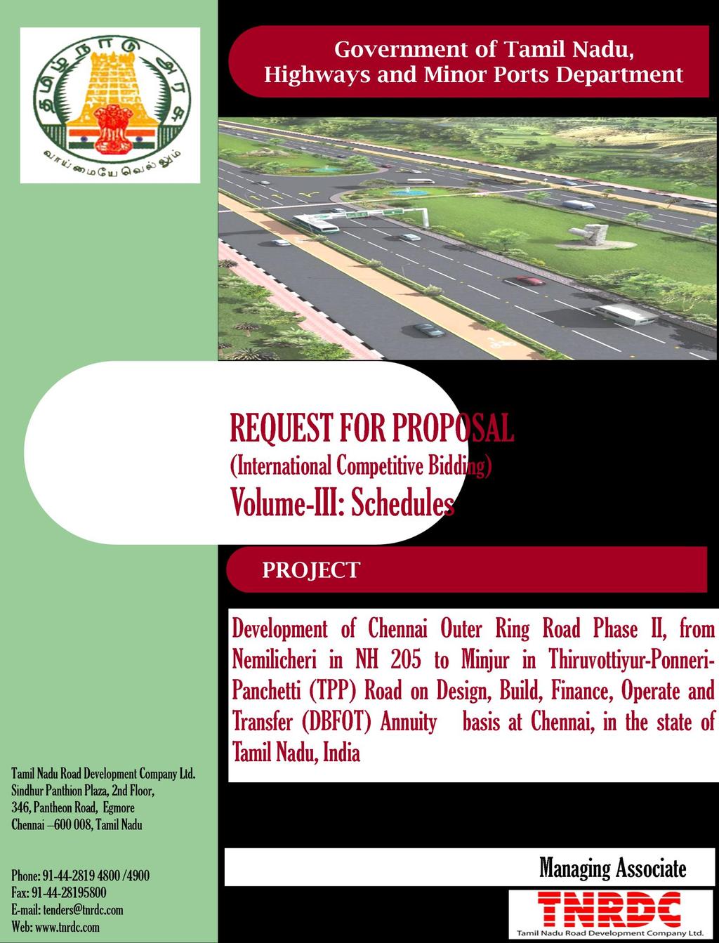
4 SCHEDULE A (See Clause 10.1) SITE OF THE PROJECT 1 The Site 1.1 Site of the Project - Six Lane Project Highway with Service Roads shall include the land, buildings, structures and road works as described in Annex-I of this Schedule-A. 1.2 An inventory of the Site including the land, buildings, structures, road works, trees and any other immovable property on, or attached to, the Site shall be prepared jointly by the Authority Representative and the Concessionaire, and such inventory shall form part of the memorandum referred to in Clause of the Agreement. 1.3 Additional land, if required, for grade separators, flyovers, underpasses, grade junctions, traffic aid posts, medical aid posts, vehicle rescue posts and other structures / components if any, or for construction of works specified in Change of Scope Order shall be acquired in accordance with the provisions of this Agreement. Upon acquisition, such land shall form part of the Site and vest in the Authority. 1.4 Site of Six Lane divided Highway with Service Roads and Rights of The Concessionaire and the Authority Notwithstanding anything to the contrary contained in this Agreement; the Site of Six Lane divided Highway with Service Roads includes two strips of 25 m each for Highways mode of transport (Main Carriage Way with Service Road) and Public Transportation Corridor of 22m width. The rights shall be as stated: 1) The Concessionaire shall have exclusive rights for two strips of 25m each for development of the Project Highway. The right of utilization and development of the remaining ROW (Total 72m; comprising 50m Future Development Corridor and 22m PTC), at any point during the Concession Period, shall vest with the the Authority. 2) The Public Transportation Corridor of 22m width: The Concessionaire shall be provided access to 22m PTC till the Authority undertakes Development of PTC. All the rights of PTC remain with the Authority throughout the Concession Period. Such access to PTC shall be provided to the Concessionaire to the extent to facilitate in discharging its obligation of maintaining effective drainage for both 25m highway development strips, protection of PTC from encroachments and its removal, project development works for Cross movements of Vehicles and Pedestrians and 2
5 accommodating of road embankment slopes but not for the slopes of high embankment locations at approaches to structures (i.e. underpasses, RoBs, grade separators, major/minor bridges). At any point of time, during the entire Concession Period, the Concessionaire shall not undertake any development in PTC beyond stipulations of the Concession Agreement, unless directed by the Authority. 3
6 Annex-I 1.1 The Site (SCHEDULE A) Authority as part of its plan has proposed development of Outer Ring road (ORR) Phase II along the periphery of Chennai Metropolitan Area (CMA) in Thiruvallur District of TamilNadu with the objective of relieving congestion within the city and also for catalysing the even dispersal of urban growth. The ORR shall provide orbital linkages to the major radials as well as decongest the traffic flow on the existing major roads including the Inner ring Road (IRR) and disperse the Urban growth over a large area. The proposed ORR phase II connects NH 205(Chennai Thiruthani High Road),NH5 (Grand Northern Trunk Road) and Thiruvottiyur-Ponneri-Panchetti (TPP) Road. The entire stretch is divided into two segments and proposed to be implemented in two phases. Phase II Segment I NH 205 to NH 5 Ch. Km to Km Segment II NH 5 to TPP Road Ch. Km to Km Segments I and II (Approx. Length of Km) connecting NH-205 near Nemilichery village and TPP road near Minjur are proposed to be taken up for implementation in this second phase, and hereinafter referred to as the Project Highway. The Project highway is proposed to be developed as a six lane divided carriageway with service roads. 1.2 Disclaimer The data presented in this schedule is for an initial understanding and guidance of the concessionaire. Authority or TNRDC will not be responsible for any inaccuracy in the information provided and shall not be liable for or be bound by the data in the information provide and shall not be liable for or be bound by the data used by the Concessionaire in evaluating the project viability. The concessionaire will carry out his own independent surveys for assessing actual position of the project highway. The Concessionaire acknowledges that prior to the execution of this Agreement, the Concessionaire has satisfied himself (based on his own independent assessment) of the survey data, specifications and standards, site and all information provided by the Authority. The concessionaire acknowledges and accepts the difficulties, risks and hazards likely to arise during the course of performance of his obligations hereunder. 4
7 1.3 Description of the Project Highway The index map and location of the Project Highway is given in Figure A-1. The alignment proposed passes through agriculture lands and small built up areas Linear Chainage Referencing System Design Chainages given the lists are to be used as reference for the entire length of the Project Highway. Using these as references, the Concessionaire shall, establish the Design Chainage for the Project Highway based on detailed topographic surveys Start and End of Project Highway The approximate length of the Project Highway is 30.5 kms. The Project Highway starts at Nemilichery in National Highway 205 i at the end of Chennai ORR Phase 1 and ends near Minjur in TPP road Latitudes & Longitudes The Project Highway lies between latitude and longitude and latitude and longitude Terrain The alignment passes through plain terrain. 1.4 Traffic The indicative traffic estimates for the Project Highway due to the future development along the Project Highway is given in Tables A-1 to A-2. 5

8 Figure A-1: Chennai Outer Ring Road Phase II Phase II Phase-I 6
9 Table A-1 Estimated Total Traffic on Section1 NH 205 to NH 5 Year LC V 2A Trucks 3A Trucks MA V Car Bus Two Wheeler Load Auto Aut o Agricultural Tractors Total Traff ic (in Veh) Total Traff ic (in PCUs ) 1111 Tollabl e Traffic (in Veh) Tollabl e Traffic (in PCUs) Year LCV 2A Truc k 3A Truck Table A-2 Estimated Total Traffic on Section 2: NH 5 to TPP Road MA V Car Bus Two Wheeler Load Auto Aut o Agricultural Tractors Total Traff ic (in Veh) Total Traff ic (in PCUs ) Tollabl e Traffic (in Veh) Tollabl e Traffic (in PCUs)
10 Year LCV 2A Truc k 3A Truck MA V Car Bus Two Wheeler Load Auto Aut o Agricultural Tractors Total Traff ic (in Veh) Total Traff ic (in PCUs ) Tollabl e Traffic (in Veh) Tollabl e Traffic (in PCUs)
11 1.4.1 Land Use Pattern Land use pattern along the project corridor is predominantly agricultural, barren land. Few structures residences, commercial establishments and educational institutions are also located along the corridor. Land use pattern along the project corridor is given in the Table A-3 Table A-3 Details of Land Use Pattern adjacent to Project Corridor S. No Chainage Left Side Right Side to to to to to to to to to to to to to to Residential area/barren Agricultural, Pallavedu lake. Pallavedu lake and residential area Agricultural and Commercial area Barren Commercial area and barren Barren Educational Institutional area and barren Barren SIDCO, Eucalyptus plantation, Barren SIDCO Barren/agricultural Barren, Commercial /residential area Commercial / residential area. Residential area Agricultural/ Pallavedu lake Barren, residential area, Educational institutions Agricultural Barren Barren/Residential area Barren Educational Institutional area and barren Coconut Plantation and barren Eucalyptus plantation, barren Educational institution area, residential area Commercial area, barren/agricultural. Barren/ residential area Coconut Plantations and Commercial / residential area 9
12 S. No Chainage Left Side Right Side to to to to to to to to to to to Barren Commercial area and barren. Pannivakkam Lake Barren/ Agricultural Agricultural, residential area. Agricultural Periyamullaivoyal lake and agricultural Agricultural Kosathalayar River Agricultural and barren. Barren and Commercial area Agricultural, barren, and residential area Commercial area and barren Pannivakkam Lake Barren/agricultural Residential and agricultural. Agricultural Periyamullaivoyal lake Agricultural. Kosathalayar River Agricultural and barren. Barren and Education Institutional, Commercial area Road Geometrics The proposed alignment traverses through plain terrain. The Concessionaire shall prepare suitable designs for Horizontal and Vertical alignment as per IRC standards. The geometric designs shall be carried out within the available RoW and shall be finalized after discussions with IE and approval by IE/the authority Road Inventory The alignment length of km (approx.) traverses through plain terrain. The proposed alignment is a green-field alignment to be developed on a new formation, and shall be constructed as per the provisions of schedule B, C and D Land The land width available is 122 metres, and includes: (a) a 50 m road land width (in two strips of 25m each) allocated for project; (b) a strip of 22m earmarked for locating a 10
13 Public Transportation Corridor (PTC) within the ROW (in-between the two strips of 25m for the main carriageway), and, (c) a strip of 50 m, earmarked for future development on the inner side of the alignment. The ROW available for the Concessionaire for the development of the Project Highway shall be limited to the 50m road land width (in two strips of 25m each) allocated for Highways mode of transport. The right of utilization and development of the remaining ROW, at any point during the Concession Period, shall vest with the Authority. The Concessionaire shall have no objection during any time of the concession period for access to Government or its nominated agencies on development in the 22m and 50m strip of land. The Site of the Project Highway comprises the land described below: S. No. Village Chainage 1 Thiruninravur to Pallavedu to & to Mukthapudupettai to Mittanamallee to Pulikuttai to Vellacheri to Tenambakkam to Morai to Vellanur to Pammadukulam to Attanthangal to Vijayanallur to Padiyanallur to Nallur to Pannivakkam to
14 S. No. Village Chainage 16 Siruniyam to Sothupakkam to Angadu to Kummanur to Kandigai to Marambedu to Arumandai to Pudupakkam to Periyamullaivoyal to Chinnamullaivoyal to Valuthigaimedu to Seemapuram to Minjur to Road Crossings/Junctions There are in total 49 road crossings / junctions along the Project Highway, which includes 11 major intersections of primary importance with NH and SH and 38 minor intersections of secondary importance with MDR, ODR or Village roads Details of proposed structures and facilities (a) No. of Major Bridges - 1 (b) No. of Railway Over Bridges/ Road under Bridge - Nil (c) No. of Grade Separators - 2 (d) No. of Minor Bridges - 2 (e) No. of Vehicular Underpasses
15 (f) No.of Pedestrian Underpasses - 17 (g) No. of Culverts - 98 The total number of bus bays and truck lay byes on the Project Highway is noted below: (a) No. of Bus bays on LHS - 25 (b) No. of Bus bays on RHS - 25 (c) No. of Truck lay-byes on LHS - 1 (d) No. of Truck lay-byes on RHS Shifting of Utilities Existing utilities within the ROW acquired for the Project Highway will require relocation. The utilities impacted include optical fibre cable (OFC), electrical poles, telephone poles, high-tension cable towers, water mains etc Drainage There are no existing drainage facilities within the proposed ROW. The designs for the Project Highway shall include adequate provisions for overall drainage (cross drainage and longitudinal and/or road side) as per standards. 13
16 SCHEDULE - B (See Clause xx) DEVELOPMENT OF THE PROJECT HIGHWAY 1 Development of the Project Highway Development of the Project Highway shall include construction of the Project Highway as described in this Schedule-B and in Schedule-C. 2 Six Lane 2.1 Six Lane shall include construction of the Six Lane with service roads on either side described in Annex-I of this Schedule B and Annex-I of Schedule C. 2.2 Six Lane shall be undertaken and completed by the Concessionaire in conformity with the Specification and Standards set forth in Schedule-D. 14
17 1 Width of Carriageway Annex I (Schedule-B) Description of Six Lane-Project Highway 1.1 The paved carriageway shall be 36 meters wide, as proposed in the typical cross-section (figure B-1), which includes (i) dual three lane carriageway, each 10.5m wide, (ii) 2.0m wide paved shoulders (1.0m wide on either side of the main carriageway), on each direction, and, (iii) 5.5m wide service roads, on either side of the divided highway. 1.2 Except as otherwise provided in this Agreement, the width of the paved carriageway shall conform to clause 1.1 above. 2 Project facilities Project Facilities shall be constructed in conformity with Annex- I of Schedule C. 3. Specifications and Standards Project Highway shall be constructed in conformity with the Specifications and Standards specified in Schedule D. 4. Features of Six Lane- Project Highway 4.1 General The description of the requirements for the various elements of the Project Highway given herein under is the bare minimum requirements of the Project. The locations for the proposed elements of the Project Highway shall be finalized in consultation and approval from IE and Authority. The scope of work shall be as per Stipulations of this Schedule B and Schedule C and constructed in accordance with the Specifications and Standards mentioned in Schedule D, and includes, Construction of a new Six-Lane divided carriageway with service roads (approx. length of km); Construction of 5.5 m wide service roads, one on each direction, with 2.0m wide planter strips between the service roads and the main carriageway; Construction of footpaths, with covered drain and utility duct for the full length of the Project Highway, one each along the edge of the service road in both directions; 15
18 Development of 49 intersections; Construction of 1 major bridge, 2 minor bridges, 5slab culverts and 73 box culverts. Provision for an additional 20 culverts are included in the Scope of works for which locations shall be finalised by concessionaire in discussion with IE and Authority ; Construction of 8 VUPs and 14 PUPs. Provision for additional 3 PUPs shall be included in the scope for which location shall be finalised by concessionaire in discussion with IE and Authority. Construction of a minimum of 50 bus bays with passenger shelters, 25 on either side of the Project Highway; Construction of traffic safety measures; Construction of wayside amenities, truck lay-bys and other road side facilities; and, Provision of additional facilities like illumination, landscaping and tree planting, roadside furniture and a system for efficient traffic management. Notwithstanding the details enclosed with this schedule, the Concessionaire shall himself carryout and be responsible for engineering surveys, investigations and detailed engineering designs and prepare the working drawings for all components relevant for development of the Project Highway to fulfil the scope of the Project as envisaged in this Agreement. All General Arrangement Drawings (GAD) shall be reviewed and approved by the Independent Engineer (IE). The concessionaire shall maintain the different elements of the Project Highway and facilities thereon as per the maintenance requirements described in Schedule K. 4.2 CORE CONSTRUCTION REQUIREMENT In the planning, design and execution of the Works and other works in connection with the repair, maintenance or improvement of the Project Highway and functions associated with the construction of the Project Highway and roadside facilities, the Concessionaire shall take all such actions and do all such things (including, but not limiting to, organizing itself, adopting measures and standards, executing procedures, including inspection procedures and highway patrols, and engaging and managing contractors, agents and employees) as will: Enable Authority to provide safe highway in respect of its condition (structural safety) and use (road safety); Enable Authority to fulfil its statutory and common law obligations; 16
19 Enable the Police, local authorities, and others with statutory duties or functions in relation to the Project Highway or adjoining roads to fulfil those duties and functions; Minimize the occurrence and adverse effects of accidents and ensure that all accidents and emergencies are responded to as quickly as possible; Minimize the risk of damage, destruction or disturbance to third party property; Ensure that members of the public are treated with all due courtesy and consideration; Provide a safe, clear and informative system of road signs; Comply with any specified program requirements, including for the completion of the new road; Enable standards of reliability, durability, accessibility, maintainability, quality control and assurance, and fitness for purpose appropriate to a highway of the character of the Project Highway to be achieved throughout the Contract Period; Achieve a high standard in the appearance and aesthetic quality of the Project Highway and achieve integration of Project Highway with the character of surrounding landscape through both sensitive design and sensitive management of all visible elements; Undertake proper safety audit through an appropriate expert of the IE team. Carry out accident recording and reporting (to IE and Authority) by type on regular basis; and Ensure adequate safety of the Project Workers on the work Site. 4.3 CROSS SECTIONS The Project Highway shall be a 6-lane divided carriageway with paved shoulders and 5.5 m wide service road separated by planter strip on both sides as per cross section type given in Table B-1. The typical cross section of 6-lane with paved shoulder with 22.0m of land reserved in between for accommodating a Public Transportation Corridor (PTC) as indicated in Figure B-1 to B3, is applicable for the Project Highway. The typical cross section shall be followed along with the design standards, indicated in Schedule D for development of the Project Highway. The alternative cross section of the Project Highway at cross drainage structures shall follow the typical cross sections in consultation with IE and Authority at the time of detailed design prior to construction. Along the Project Highway, provisions for the utility services, including optical fibre cables, shall be provided in the utility duct earmarked for this purpose. The location of the utility duct shall be finalized by the Concessionaire, in consultation with the concerned Authority and the approval of IE and Authority. For cross connections, the utility services shall be carried through the nearest cross drainage structure/cattle crossing below its deck slab and above HFL. Location and 17
20 design of the cross utility ducts, if required, shall be finalized at the detailed design stage in consultation with the IE and Authority. Minor alterations/ modifications can be carried out to the alignment plan within the overall suggested cross-section, along with proper justification, in consultation and approval from IE and Authority. 18
21 Figure B-1 Note : Typical Cross Section shown here are indicative only 19 Design, Build, Finance, Operate and Transfer (DBFOT) Annuity basis
22 Figure B-2 Figure B-2 Note : Typical Cross Section shown here are indicative only 20 Design, Build, Finance, Operate and Transfer (DBFOT) Annuity basis
23 Figure B-3 Note : Typical Cross Section shown here are indicative only 21 Design, Build, Finance, Operate and Transfer (DBFOT) Annuity basis
24 Table B-1: Type of Road Cross Sections Segment Location Cross Section NH-5 TPP Road From To I NH-205 NH-5 Figure B-1 II NH-5 TPP Road Figure B ALIGNMENT PLAN The alignment plan and vertical profile of the Project Highway shall be prepared and finalized by the Concessionaire in consultation with and approval from IE and Authority. The Finished Road Top Level (FRL) shall conform to the design standards stipulated through Schedule D of this Concession Agreement. 4.5 SERVICE ROADS Service roads (5.5m wide), one each on the LHS and RHS of the divided six lane carriageway, for the entire length of the Project Highway shall be designed and constructed. Planter strips of 2.0m width will separate the main carriageway and service roads PAVEMENT General The pavement design including pavement characteristics requirements of the Project Highway and that of the service roads in Urban Sections shall be done in accordance with Schedule D. Pavement shall be flexible for main carriageway, paved shoulders, service roads, pick up bus stops, Truck lay-byes, wayside amenities complex and for cross roads up to ROW limits. To ensure internal drainage of the pavement structure, the lower drainage layer or filter layer of the road sub base shall extend up to full formation width. Roughness value of the flexible pavement on completion shall not be more than 1800 mm per km (for both Main Carriage Way and Service Roads) measured jointly (by The Concessionaire, The IE and Authority) with Bump Integrator fitted in a vehicle or an equivalent device approved by the IE and Authority. The instrument used in the measurement of roughness shall be duly calibrated. 22
25 4.6.2 Pavement composition The pavement composition for the main carriageway shall be designed as per IRC: The concessionaire shall design the pavement for design life of 20 years with minimum of 100msa (Million Standard Axles) and should be designed for a minimum CBR of 6% (Soaked CBR). The pavement composition shall be reviewed and approved by IE and Authority prior to the execution Paved Shoulder composition The paved shoulders shall be designed as an integral part of the pavement for the main carriageway. The pavement thickness of the paved shoulders shall be the same as in the main carriageway Pavement Composition for Service Road The pavement composition for service roads shall be designed as per IRC: The concessionaire shall design the pavement for design life of 20 years and design MSA shall be 10 MSA (Million Standard Axles) and should be designed for a minimum CBR of 6% (Soaked CBR) 4.7 Intersections/ Junctions (AT GRADE) All major and minor intersections shall be designed and developed in accordance with standards mentioned in Schedule-D. The tentative locations of intersections are listed in Table B-2 and Figure B-4. Table B-2 At Grade Intersections S. No. Chainage Width (m) Cross Road Description Type Type of Junction Road Connectivity BT road/gravel road ( ) Village road BT road ( ) Village road Mud road T Junction Village road Mud road ( ) Village road 23
26 S. No. Chainage Width (m) Cross Road Description Type Type of Junction Road Connectivity Mud road ( ) Village road BT road ( ) Village road Foot path ( ) Village road Mud road ( ) Village road Mud road ( ) Village road BT road ( ) Village road BT road ( ) Village road Foot path ( ) Village road Mud road ( ) Village road Mud road ( ) Village road Foot path ( ) Village road BT road ( ) Pallavedu- Avadi Cement Road ( ) Village road BT road ( ) Mittanamallee- Pallavedu Mud road (inspection road) ( ) Village-Morai Mud road ( ) Village road BT road ( ) BT road ( ) Keezhikondakarai- Morai Keezhikondakarai- Avadi BT road ( ) Veerapuram- Avadi 24
27 S. No. Chainage Width (m) Cross Road Description Type Type of Junction Road Connectivity BT road ( ) Mud road ( ) Mud road ( ) BT road ( ) Veerapuram (Police Camp)- Avadi Veerapuram (Police camp)- Educational Institutions Educational Institutions Vel s group of institution- Avadi Mud road ( ) SIDCO-Village Mud road ( ) SIDCO- Village Mud road ( ) SIDCO- Village BT road ( ) Redhills- Avadi BT road ( ) Avadi- Lakshmipuram BT road ( ) Avadi-Redhills Four lane divided carriageway (7m Carriageway+ 1.2m Median) BT road (SH-114) ( ) Thiruvallur- Redhills BT road ( ) Attanthangal- Village & BT road ( ) Attanthangal- Village BT road ( ) Village road 25
28 S. No. Chainage Width (m) Cross Road Description Type Type of Junction Road Connectivity Four lane divided carriageway (dual 7.5 carriageway with1.5 Paved shoulder and 4.5m median) BT road (NH- 5) ( ) Tada-Chennai Gravel road ( ) Pannivakkam- Agricultural field BT road ( ) Pudur-Kummanur BT road ( ) BT road ( ) Kandigai- Agricultural field Agricultural field- Village BT road ( ) Pudur-Arumandai BT Road ( ) WMM road ( ) Kandigai- Agricultural field Arumandai- Madhavaram Gravel road ( ) Village road BT road ( ) BT road ( ) Seemapuram- Periyamullaivoyal Village- Seemapuram BT road (TPP road) ( ) Cholavaram- Ennore 26
29 Figure B-4: Major intersection 27 Design, Build, Finance, Operate and Transfer (DBFOT) Annuity basis
30 4.8 STRUCTURES Major and Minor Bridges The major and minor bridges shall be designed in accordance with the Design Standards and Specifications set in Schedule D. Construction of 1 major bridge and 2 minor bridges in Project Highway, listed in Table B-3 and B-4 are the minimum requirement. The designs, drawings, and locations shall be approved by IE and Authority. The adequacy of the vent size for all bridges shall be ascertained through detailed hydrological surveys and finalized in consultation with the IE and Authority. The Highest Flood Level / Maximum Supply Level shall be properly assessed after collecting flood histories from local authorities/ interviews with local residents / Irrigation authorities etc. Canal bridges shall be designed as per hydraulic requirements of irrigation department or concerned authorities. The construction plans shall be prepared as per closure schedule of canals. Approval of GAD from irrigation department or concerned authorities, as required shall be obtained by the Concessionaire. The cross drainage plan of the Project Highway shall be finalized in consultation with IE and Authority and additional culverts provided, if required. Table B-3 List of Major Bridge Locations S. No. Chainage Type Structure of Length (m) Remarks Major Bridge 10 x 25m Kosathalayar River Table B-4 List of Minor Bridge s Locations S. No. Chainage Type Structure of Span (m) Remarks Minor Bridge 1 x 20 Krishna Canal Minor Bridge 1 x 30 Kandaleru Canal Cross Drainage Structures The Concessionaire shall design the cross drainage structures in accordance with the Standards and Specifications set in Schedule-D. Construction of 5 slab culverts and 73 box 28
31 culverts is the minimum requirement. In addition, a provision of 20 box culverts shall be included in the Scope of Works, to be decided as per the site conditions during the Project Development period. Culverts of LHS and RHS shall be connected with lined channel across PTC with suitable slope to ensure smooth flow of water from upstream to downstream. The tentative locations of these structures are given in Table B-5, and the locations of these and the additional culverts shall be finalized in consultation with the IE and Authority. Table B-5 List of Culvert s Locations S. No. Chainage Type Structure of Span/Size of Culvert Proposed Culverts Box Culvert 2 x 1.5m Balancing culvert Box Culvert 2 x 1.5m Balancing culvert Box Culvert 2 x 1.5m Balancing culvert for Pallavedu lake Box Culvert 2 x 1m Water stream from Pallavedu lake Box Culvert 2 x 1m Local drain near the Existing road Box Culvert 3 x 2m Pond in Pallavedu Box Culvert 2 x 1.5m Balancing culvert Box Culvert 2 x 1m Local drain near the existing road Box Culvert 2 x 1.5m Balancing culvert Box Culvert 2 x 1.5m Balancing culvert Box Culvert 2 x 1.5m Balancing culvert Box Culvert 2 x 1.5m Balancing culvert Box Culvert 2 x 1.5m Balancing culvert Box Culvert 2 x 1.5m Balancing culvert Box Culvert 2 x 1.5m Balancing culvert Box Culvert 2 x 1m Local drain near existing road. 29
32 S. No. Chainage Type Structure of Span/Size of Culvert Proposed Culverts Box Culvert 2 x 1.5m Balancing culvert for the pond near existing road Box Culvert 2 x 1m Local drain along the existing road Box Culvert 2 x 1m Local drain along the existing road Box Culvert 2 x 1.5m Balancing culvert Box Culvert 2 x 1.5m Balancing culvert Box Culvert 2 x 1m Local drain near existing road Box Culvert 2 x 1m Local drain near existing road Box Culvert 2 x 1.5m Balancing culvert Box Culvert 2 x 1.5m Balancing culvert Box Culvert 3.5 x 1m Water Stream near SIDCO Box Culvert 2 x 1.5m Balancing culvert Box Culvert 2 x 1.5m Balancing culvert Box Culvert 2 x 1.5m Balancing culvert Box Culvert 2 x 1m Water Stream near Polytechnic College Box Culvert 2 x 1.5m Balancing culvert Box Culvert 2 x 1.5m Balancing culvert Box Culvert 2 x 1.5m Balancing culvert Box Culvert 3.5 x 1.0m Proposed for local irrigation channel Box Culvert 2 x 1.5m Balancing culvert Box Culvert 2 x 1.5m Balancing culvert 30
33 S. No. Chainage Type Structure of Span/Size of Culvert Proposed Culverts Box Culvert 2 x 1.5m Balancing culvert Box Culvert 2 x 1.5m Balancing culvert Box Culvert 2 x 1m Local drain near existing road Box Culvert 2 x 1m Local drain near existing road Box Culvert 2 x 1.5m Balancing culvert Box Culvert 2 x 1.5m Balancing culvert Box Culvert 2 x 1.5m Balancing culvert Slab culvert 2 x 1m Water Stream near Kandaleru canal Box Culvert 3.5 x 1.5m Balancing culvert Box Culvert 3.5 x 1.5m Balancing culvert Box Culvert 2 x 1m Local drain near NH Slab Culvert Slab Culvert Slab Culvert Slab Culvert 2 x 1.5m Balancing culvert for Pannivakkam lake. Maximum depth will be 5 to 6 feet. 2 x 1.5m Balancing culvert for Pannivakkam lake. Maximum depth will be 5 to 6 feet. 2 x 1.5m Balancing culvert for Pannivakkam lake. Maximum depth will be 5 to 6 feet. 2 x 1.5m Balancing culvert for Pannivakkam lake. Maximum depth will be 5 to 6 feet Box Culvert 2 x 1.5m Balancing culvert 31
34 S. No. Chainage Type Structure of Span/Size of Culvert Proposed Culverts Box Culvert 2 x 1.5m Balancing culvert Box Culvert 2 x 1m Local drain along the existing road Box Culvert 3.5 x 1.5m Balancing Culvert Box Culvert Pond near existing road Box Culvert 2 x 1.5m Balancing Culvert Box Culvert 2 x 1.5m Balancing culvert Box Culvert 2 x 1.5m Balancing culvert for Marambedu lake Box Culvert 2 x 1.5m Balancing culvert Box Culvert 2 x 1.5m Balancing Culvert Box Culvert 2 x 1m Pond in Kandigai Box Culvert 2 x 1.5m Balancing culvert Box Culvert 2 x 1.5m Balancing culvert Box Culvert 2 x 1.5m Balancing culvert Box Culvert Box Culvert 2 x 1.5m Balancing culvert for Periyamullaivoyal lake. Max water depth will be 4-5 feet along the project corridor. 2 x 1.5m Balancing culvert for Periyamullaivoyal lake. Max water depth will be 4-5 feet along the project corridor Box Culvert 2 x 1.5m Balancing culvert Box Culvert 2 x 1.5m Balancing culvert 32
35 S. No. Chainage Type Structure of Span/Size of Culvert Proposed Culverts Box Culvert 2 x 1.5m Balancing culvert Box Culvert 2 x 1.5m Balancing culvert Box Culvert 2 x 3 x 1.5m Balancing culvert Box Culvert 2 x 1.5m Balancing culvert Box Culvert 2 x 1.5m Balancing culvert Box Culvert 2 x 3 x 1.5m Balancing culvert Box Culvert 2 x 1.5m Balancing culvert Box Culvert 2 x 1.5m Balancing culvert Box Culvert 2 x 3 x 1.5 Local drain near TPP road. Additional 20 No of Culverts shall be added for which location will be finalised during execution Grade Separators There are two Grade separators to be provided by the Concessionaire along the Project Highway. Details and tentative locations of grade separators are furnished in Table B-6(A) and B-6 (B) and typical layout is presented in Figure B6. The backfill in the approaches will be protected by providing reinforced earth/ RCC retaining walls. 33
36 Table B-6 (A) List of Interchange / FlyoverLocations S. No. Chainage Type of Structure Full cloverleaf Interchange Minimum Vertical Clearance (m) Type of Major intersection Kolkotta Highway) Span Arrangement 4 x x x 20 with 17 m wide deck for obligatory and adjoining spans on the clover leaf portions. Clover leaf and balance ramps shall be with RE wall. Table B-6 (B) S. No. Chainage Type of Structure Span Arrangement (m) Flyover 2 x x 30 Road Connectivity 5.5 NH-5 (Chennai- Thiruvallur- Redhills (SH-114) Minimum Vertical Clearance (m) Width (m) Note: The dimensions furnished are the minimum requirements and the concessionaire has to prepare the detailed designs in consultation with the NHAI, TNHD and other relevant agencies, obtain approvals and any increase in the requirement will be at the risk and cost of the concessionaire. 34
37 Figure B-6: Typical Layout of Clover leaf 35 Design, Build, Finance, Operate and Transfer (DBFOT) Annuity basis
38 Figure B-7: Typical Layout of Busbay 36 Design, Build, Finance, Operate and Transfer (DBFOT) Annuity basis
39 4.9 Underpasses Vehicular underpasses The Concessionaire shall provide underpasses as given in Table B-7. The dimensions furnished here are for one carriageway the same has to be followed for the other carriageway also to accommodate six lane wide road with service road configurations. Any related ancillary works in this regard, which are required to be executed to ensure proper connectivity and elevations envisaged for the Project Highway shall be covered in the Scope of work under this Concession Agreement Table B-7 List of VUP s Locations S. No. Chainage* Size (m) Clear Height Total Width (m) Road Connectivity x Pallavedu-Mittanamallee x Keezhikondakarai-Avadi x Vel s group of Institution- Avadi x Redhills-Avadi x Redhills-Avadi x Pudur-Kummanur x Pudur-Arumandai x Semmapuram- Periyamullaivoyal 37
40 4.9.2 Pedestrian Underpasses The Concessionaire shall provide pedestrian underpasses as given in Table B-8. Table B-8 List of PUP s Locations S. No. Chainage Span (m) Road Connectivity Note: x 4 Thirunandriyur village x 4 Pallavedu-Avadi x 4 Keezhikondakarai-Morai x 4 Veerapuram, Vel s hostel- Vel s Engg. College, Avadi 6 x 4 SIDCO-surrounding settlement 6 x 4 Seemapuram- Periyamullaivoyal x 4 Avadi-Redhills x 4 Arumandai-Madhavaram x 4 SIDCO-Surrounding village 6 x 4 Pammadukulam, Avadi- Lakshmipuram x 4 Surrounding village x 4 Pannivakkam-Agricultural field. 6 x 4 Marambedu-Agricultural Field x 4 Arumandai-Madhavaram Provision of 3 additional pedestrian underpasses shall be included in the scope of works, to be decided as per the site conditions during the project development period. 38
41 4.10 Drainage Measures The drains along the Project Highway shall be designed in accordance with the design standards set in Schedule D. The drainage plan shall be prepared by the concessionaire and approved from IE and Authority, and shall include, but not be limited to, the following: i) Efficient drainage scheme shall be prepared for the 22m wide PTC to enable drainage of water from the PTC.Unlined drains shall be provided at the centre of the PTC and, ii) Covered Pucca drains shall be provided at outer edges of service roads, along the Project Highway with proper connection to the outfall location. Chute drains along with kerbs and channel drains in high embankment (3m and above), and, iii) Covered pucca drains underneath the footpath (bus bays, truck lay byes etc.) Slope Protection Measures The slope protection measures along the Project Highway shall be designed in accordance with the design standards set in Schedule D Traffic Signs and Pavement Traffic signs and pavement markings shall include roadside signs, overhead signs, kerb mounted signs and road marking along the Project Highway. The designs for traffic signs and pavement markings for the Project Highway shall be as per the design standards indicated in Schedule-D. The location for provision of traffic signs and pavement markings shall be finalized in consultation with the IE Lighting The lighting on the Project Highway shall be carried out for the entire length of the Project Highway, in accordance with the requirements for Urban Roads. The design of the lighting system on the Project Highway shall be as per the design standards set in Schedule D for urban stretches Light Emitting Diode (LED) LEDs shall be provided by the Concessionaire at bus bay locations as per the design standards set in Schedule D Blinkers at Intersection Blinkers shall be provided by the Concessionaire at all major intersections as per design standards set in Schedule D. 39
42 4.16. Delineators and Guard Posts Delineators shall be provided at all Horizontal curves as per the design standards in Schedule D. Guard posts shall be provided on either side of the carriageway, as per the design standards indicated in Schedule D Safety Barriers Metal beam safety Barrier shall be provided on all outer periphery of curves with radius of 600 m and less. The barriers will also be provided on either side of the carriageways, at locations where the embankment height is greater than 3m, as per the design standards. Safety barriers shall be provided on the approaches of all minor and major bridges,pup and VUP locations on both left and right sides as per design standards set in Schedule D Studs Road studs shall be provided by the Concessionaire at all curves on both carriageways, at median openings and at intersections as per the design standards spelt out in schedule D. 5 Guard Rail and Traffic Safety Devices The following shall be provided by the Concessionaire: i) For the safety of pedestrian at the intersection / Junction, guard rails in GI pipe shall be provided. ii) Metal beam / Concrete Barriers shall be provided at locations of bridge,pup and VUP approaches and high embankments (3m and more) and at curves having deflection angle more than 30 o. Metal beam barrier shall be of w- shape, in Fe 410 grade with single runner hot dip galvanized in 550 gm/sq.m. 6. Landscaping The finished road facility shall exhibit adequate landscaping of aesthetically pleasing view. Landscaping with shrubs shall be carried out in planter strips, as per IRC: SP- 21.All the borrow areas used for the project shall be rehabilitated. 40
43 7. Right of Way (RoW) Boundaries Right-of-Way (RoW) boundaries of the Project Highway shall be marked and demarcated by fixing RCC boundary pillars size 60 cm x 15 cm x 15 cm embedded in concrete (as per IRC) along the Project Highway at 100 m interval on both sides. At junctions and curves, the interval between boundary pillars will be reduced to 50m. All the components used in delineating road land boundary shall be aesthetically pleasing, sturdy and vandal proof. The road land boundary shall be demarcated in consultation with IE and Authority. In case of damages during maintenance period, these shall be replaced by the concessionaire at their cost. A system for the identification of chainages along the Project Highway shall be prepared in consultation with IE. 8. Pre-Construction Activities 8.1 Land Acquisition (LA) In case of additional land requirement, for the development of project highway, the same shall be acquired by the Authority. The cost of such land acquisition shall be borne by Authority. However the Concessionaire shall be involved pro-actively in this regard submitting all relevant land acquisition proposals as per Tamil Nadu Highways Act 2001 and pursuing the matter with the concerned Government Departments. 8.2 Utility Shifting and Removal of Trees The project involves shifting of utilities and removal of trees within the Proposed RoW, and shall be the responsibility of the Concessionaire. The costs towards the same be borne by the concessionaire. The costs shall be based on estimates prepared by the respective Departments / Agencies as per the respective Schedule of Rates, applicable. 8.3 Encroachment Removal Encroachments, if any, within the acquired ROW, shall be removed by theconcessionaire at his own cost. Authority will provide administrative support in removal of the encroachments. 8.4 Rehabilitation & Resettlement For any Rehabilitation and Resettlement (R&R) issues arising out of the additional land acquisition, the Authority shall bear cost in this regard. However, Concessionaire shall proactively be involved for all related activities. 41
44 8.5. Environment An Environmental Impact Assessment (EIA) and Environmental Management Plan (EMP) for the Project Highway has been prepared by the Authority. The Concessionaire shall be responsible to follow and implement the environmental mitigation measures and environmental management plan for monitoring and implementation as proposed in EIA/EMP. The Project Highway is proposed to be an Urban Road. The requirements laid down in the MoEF notification (2006) for EIA requirements for Development Projects, does not include Urban Roads. The Project Highway is neither a National Highway nor a State Highway. Therefore, the Environmental Clearance requirements are not required for the Project Highway. The Concessionaire, during design, construction, operation and maintenance, shall conform to the environmental rules and regulations in force. As per Ministry of Environment and Forests Notification, New Delhi dated (and its further amendments), the construction of Rain water harvesting structure is mandatory in and around Water Crisis area, notified by the Central Ground Water Board/Tamil Nadu Water supply and Drainage Board (TWAD). Water Collected through drain should be diverted to available minor/major water bodies in consultation with IE Clearances to be Obtained The Concessionaire shall obtain all necessary clearances from all the concerned authorities required for implementing the project. 42
45 SCHEDULE C (See Clause 2.1) PROJECT FACILITIES 1 Project Facilities include: (a) (b) (c) (d) (e) (f) (g) (h) (i) (j) (k) (l) (m) (n) (o) toll plaza(s); roadside furniture; Wayside Amenities; Landscaping and tree plantation; truck lay-byes; bus-bays and bus shelters; pedestrian facilities; administrative, operation and maintenance base camp; Site office for TNRDC; Rest areas Traffic aid posts Medical aid posts Vehicle rescue posts project laboratory; and, Others ` 1. Highway Patrol vehicles and systems; 2. Facilities for emergency assistance, ambulance, crane, tow trucks 3. Advanced Traffic Management Systems (ATMS) Project Facilities for Six Lane Project Facilities forming part of the Project Highway and to be completed on orbeforethe Project Completion Date have been described in Annex-I of this Schedule-C. 43
46 Annex I (Schedule-C) 1. General PROJECT FACILITIES The following sections of this schedule indicate the details of amenities and facilities as situated on site; and minimum facilities to be provided on the Project Highway as part of the scope of work under this contract with an aim to cater to the envisaged demand till the end of the concession period. 2. Proposed Facilities 2.1 Toll Plaza Toll plazas are envisaged as per Schedule D, even though the Project Highway is proposed to be developed on DBFOT Annuity basis. 2.2 Way Side Amenities Way side amenities shall be provided at two locations by the Concessionaire in consultation with the IE and Authority. These shall have provisions for toilets, drinking water facilities, cafeteria and truck parking area, emergency health care facilities for accident victims. The location and layout plan of way side amenities shall be finalized in consultation with IE and Authority Truck Lay-byes The Concessionaire shall provide two Truck Lay-byes, with minimum provision for 50 trucks each, one on either side along the Project Highway. Lay-by shall be designed in the form of rectangle/trapezoidal area parallel and separated from the carriageway of the service road by a physical barrier. The parking lots shall be suitably landscaped. Basic facilities such as drinking water and toilets, with proper disposal system shall be provided at the lay-by location. The location and layout plan of truck lay-by shall be finalized in consultation with IE and Authority. 2.4 Bus Bays The Concessionaire shall provide a minimum of 50 bus bays along with bus stops (25 along each direction), along the Project Highway according to standards and specifications set forth in Schedule-D. The locations of these bus bays and the designs shall be finalized by the Concessionaire in consultation with the IE and the Authority. 2.5 Pedestrian Facilities - pedestrian markings The Concessionaire shall provide minimum of 17 pedestrian underpasses as specified in Schedule -B conforming to Standards set forth in Schedule D. 44
47 2.6 Lighting Lighting shall be provided by the Concessionaire along the entire length of the Project Highway, as specified in Schedule D. 2.7 Arboriculture & Landscaping Landscaping in planter strips and PTC corridor through provision of trees and shrubs shall be provided, where shrubs shall not normally exceed m heights and shall be as per IRC: SP Administrative, Operation and Maintenance Base Camp A minimum of 500 sq m (approx.) of covered area for functional base camp shall be provided by the Concessionaire. The proposed facilities available at base camp are described hereunder. a) The main administrative, operation and maintenance base camp shall be provided to cater to the requirements of the following services: Security Office; Project Highway Maintenance including functional laboratory; Facilities for storage and repair of maintenance equipments, vehicles and materials; and, Any other requirement. b) The base camp shall be housed in suitable area. The layout of the different buildings and facilities shall be finalized in consultation with the IE. c) The Administrative building shall primarily house the Main Control Centre, the Security Headquarters, the Central Store, in addition to other secondary facilities such as computer room, office space, stores, sanitary facilities, canteen etc. The main base camp shall have adequate parking space for staff and visitors. d) The maintenance area shall have a centrally located building to overlook the maintenance workshop etc. A separate storage area shall be earmarked for inflammable materials. The maintenance block shall have enough spaces to park the equipments and machinery deployed for maintenance activities. Adequate parking space shall be earmarked for the staff vehicles and visitors vehicles. In addition, there shall be adequate and well-illuminated covered parking space for all the maintenance vehicles. 45
Volume III SCHEDULES
 Request for Proposal for Development of Outer Ring Road (ORR) on Design, Build, Finance, Operate and Transfer (DBFOT) Annuity basis at Chennai, in the State of Tamil Nadu International Competitive Bidding
Architects, Engineer & Consultant Pvt. Ltd.
 Operation & Maintenance Inspection Report Month of July 2015 Project: - Design, Engineering, Construction, Development, Finance, Operation and Maintenance of Jaipur to Deoli section of NH 12 (Km 18.700
-MENDOCINO COUNTY PLANNING AND BUILDING SERVICES- DIVISION OF LAND REGULATIONS TITLE 17
 ARTICLE VI -- GENERAL REGULATIONS AND PROVISIONS Sec. 17-50. Sec. 17-51 General Plan. Sec. 17-52 Lot and Block Design and Configuration. Sec. 17-53 Lot Access. Sec. 17-54 Private Roads. Sec. 17-55 Water
ARTICLE 3 DEFINITIONS
 Sections: 3-1 Rules of Construction 3-2 Definitions ARTICLE 3 DEFINITIONS SECTION 3-1 RULES OF CONSTRUCTION 3-101. a. The language set forth in these regulations shall be interpreted in accordance with
Draft Model Access Management Overlay Ordinance
 Draft Model Access Management Overlay Ordinance This model was developed using the City of Hutchinson and the Trunk Highway 7 corridor. The basic provisions of this model may be adopted by any jurisdiction
ARTICLE 15. RULES, REGULATIONS AND DEFINITIONS
 ARTICLE 15. RULES, REGULATIONS AND DEFINITIONS Section 1. Interpretation and Construction: The following rules and regulations regarding interpretation and construction of the Ulysses-Grant County, Kansas,
Title: ENCROACHMENT POLICY Number: 0132 Reference: Administrative Committee January 21, Adopted by City Council: February 2, 2009
 POLICY Title: ENCROACHMENT POLICY Number: 0132 Reference: Administrative Committee January 21, 2009 February 2, 2009 Supersedes: May 2, 2005 Prepared by: PLANNING, BUILDING AND DEVELOPMENT SERVICES STATEMENT
JEFFERSON COUNTY, ALABAMA
 JEFFERSON COUNTY, ALABAMA Major Development Checklist, Notes and Information A Major Development is any proposed new structure or addition to an existing structure which will cause a change in the topography
DIVISION 2 - CONSTRUCTION PLAN AND MISCELLANEOUS REQUIREMENTS
 DIVISION 2 - CONSTRUCTION PLAN AND MISCELLANEOUS REQUIREMENTS 2.1 Required Plan Sheets 2.2 Drawing Requirements 2.3 Graphic Standards 2.4 Easements 2.5 Utility Locations 2.6 Private Facility Locations
REGULATIONS OF WALLER COUNTY, TEXAS
 REGULATIONS OF WALLER COUNTY, TEXAS FOR THE CONSTRUCTION OF DRIVEWAYS AND/OR CULVERTS ON COUNTY EASEMENTS AND RIGHTS-OF-WAY Adopted: 9/11/07 Revised: 3/10/11 TABLE OF CONTENTS SECTION 1 AUTHORITY 1 SECTION
KASSON TOWNSHIP PRIVATE ACCESS ROAD ORDINANCE ORDINANCE NO (EFFECTIVE: MAY 12, 2007)
") KASSON TOWNSHIP PRIVATE ACCESS ROAD ORDINANCE ORDINANCE NO. 2007-01 (EFFECTIVE: MAY 12, 2007) An ordinance providing for the standards and specifications incident to the development of Private Motor Vehicle
KASSON TOWNSHIP PRIVATE ACCESS ROAD ORDINANCE ORDINANCE NO. 2007-01 (EFFECTIVE: MAY 12, 2007) An ordinance providing for the standards and specifications incident to the development of Private Motor Vehicle
610 LAND DIVISIONS AND PROPERTY LINE ADJUSTMENTS OUTSIDE A UGB
 ARTICLE VI: LAND DIVISIONS AND PROPERTY LINE ADJUSTMENTS VI-21 610 LAND DIVISIONS AND PROPERTY LINE ADJUSTMENTS OUTSIDE A UGB 610-1 Property Line Adjustments (Property Line Relocation) A property line
7. EASEMENTS Label Established Lines Affecting Tract and/or Mentioned in its Legal Description:
 7. EASEMENTS 7.010 General All sewers shall be constructed in easements with working room. Existing easements without working room may only be used if revised to include working room. All public sewers,
TOWNSHIP OF BORDENTOWN LAND DEVELOPMENT APPLICATION CHECKLIST. General Requirements for all Applications
 TOWNSHIP OF BORDENTOWN LAND DEVELOPMENT APPLICATION CHECKLIST This CHECKLIST has been adopted in accordance with Section 25:807 of the Land Development Ordinance of the Township of Bordentown and will
SPRING BROOK TOWNSHIP 966 STATE ROUTE 307 SPRING BROOK TOWNSHIP, PA PHONE (570) FAX (570)
 FAX (570)") PERMIT # - D SPRING BROOK TOWNSHIP 966 STATE ROUTE 307 SPRING BROOK TOWNSHIP, PA 18444 PHONE (570) 842-7028 FAX (570) 842-0633 Date: PART I APPLICATION DRIVEWAY INSTALLATION APPLICATION AND PERMIT Name:
PERMIT # - D SPRING BROOK TOWNSHIP 966 STATE ROUTE 307 SPRING BROOK TOWNSHIP, PA 18444 PHONE (570) 842-7028 FAX (570) 842-0633 Date: PART I APPLICATION DRIVEWAY INSTALLATION APPLICATION AND PERMIT Name:
ARTICLE 23 CONDOMINIUM STANDARDS
 ARTICLE 23 CONDOMINIUM STANDARDS Section 23.01 Intent. The intent of this Article is to provide regulatory standards for condominiums and site condominiums similar to those required for projects developed
BRIDGETON SUBDIVISION APPLICATION CHECKLIST
 APPLICATION NAME AND # CHECKLIST COMPLETED BY: DATE: Signature and printed name BRIDGETON SUBDIVISION APPLICATION CHECKLIST TO SUBDIVISION APPLICANTS: The attached checklist is to assist you in the submission
SUBDIVISION BY-LAW MUNICIPALITY OF THE COUNTY OF INVERNESS
 SUBDIVISION BY-LAW MUNICIPALITY OF THE COUNTY OF INVERNESS APPROVED BY COUNCIL: JUNE 15, 1998 EFFECTIVE DATE: SEPTEMBER 23, 1998 Page 2 TABLE OF CONTENTS PART 1: SHORT TITLE... 5 PART 2: INTERPRETATION...
SUBCHAPTER 02C - SECONDARY ROADS SECTION SECTION SECONDARY ROADS
 SUBCHAPTER 02C - SECONDARY ROADS SECTION SECTION.0100 - SECONDARY ROADS Note: The Department of Transportation publishes a volume entitled "Minimum Design and Construction Criteria for Subdivision Streets"
a. provide for the continuation of collector streets and thoroughfare streets between adjacent subdivisions;
 Section 7.07. Intent The requirements of this Section are intended to provide for the orderly growth of the Town of Holly Springs and its extra-territorial jurisdiction by establishing guidelines for:
FINAL SUBDIVISION AND LAND DEVELOPMENT PLAN CHECKLIST. Plan Name. Applicant's Name:
 TOWNSHIP OF UPPER ST. CLAIR FINAL SUBDIVISION AND LAND DEVELOPMENT PLAN CHECKLIST Date Filed Plan Name PLC Applicant's Name: Phone Filing Date for Final Application Final Plat 114.22. FINAL APPLICATION
CITY OF FORT COLLINS NATURAL AREAS AND CONSERVED LANDS EASEMENT POLICY
 CITY OF FORT COLLINS NATURAL AREAS AND CONSERVED LANDS EASEMENT POLICY Adopted January 3, 2012 PURPOSE: The purpose of the policy statement is to clarify the policies and procedures of the City of Fort
CHAPTER 14: DRIVEWAYS, TOWN HIGHWAYS, AND PRIVATE ROADS
 CHAPTER 14: DRIVEWAYS, TOWN HIGHWAYS, AND PRIVATE ROADS TABLE OF CONTENTS CHAPTER 14: PRIVATE DRIVEWAYS, TOWN HIGHWAYS AND PRIVATE ROADS 14-1 14.0100 AUTHORITY... 14-1 14.0200 TITLE... 14-1 14.0300 REGULATION
APPLICATION PROCEDURE
 ANTRIM PLANNING BOARD P. O. Box 517 Antrim, New Hampshire 03440 Phone: 603-588-6785 FAX: 603-588-2969 APPLICATION FORM AND CHECKLIST FOR MINOR OR MAJOR SITE PLAN REVIEW File Date Received By APPLICATION
UPPER MOUNT BETHEL TOWNSHIP NORTHAMPTON COUNTY, PENNSYLVANIA
 UPPER MOUNT BETHEL TOWNSHIP NORTHAMPTON COUNTY, PENNSYLVANIA JOINDER DEED / LOT CONSOLIDATION TOWNSHIP REVIEW PROCESS When accepting proposed Joinder Deeds / Lot Consolidations, review the Joinder Deed
ARTICLE 24 PRIVATE ROAD, SHARED PRIVATE DRIVEWAY AND ACCESS EASEMENT STANDARDS
 ARTICLE 24 PRIVATE ROAD, SHARED PRIVATE DRIVEWAY AND ACCESS EASEMENT STANDARDS SECTION 24.00 INTENT AND PURPOSE The standards of this Article provide for the design, construction and maintenance of private
THE COUNTY BOARD OF SUPERVISORS OF THE COUNTY OF DOUGLAS DOES ORDAIN AS FOLLOWS:
 8.1 SUBDIVISION CONTROL ORDINANCE THE COUNTY BOARD OF SUPERVISORS OF THE COUNTY OF DOUGLAS DOES ORDAIN AS FOLLOWS: SECTION I. GENERAL INTERPRETATION This ordinance shall not repeal, impair or modify private
Land Improvement Act
 Issuer: Riigikogu Type: act In force from: 01.09.2015 In force until: 31.12.2017 Translation published: 04.09.2015 Amended by the following acts Passed 22.01.2003 RT I 2003, 15, 84 Entry into force 01.07.2003,
DRAFT DEED OF SUB LEASE
 1 Draft Deed of Sub-lease DRAFT DEED OF SUB LEASE THIS DEED OF SUB LEASE ( Sub-lease ) entered into at Chennai on this the------- day of. 2011 between M/s. Tamil Nadu Road Development Company Limited with
PROVINCIAL PUBLIC HIGHWAY PERMIT APPLICATION
 PERMIT APPLICATION District File Number Your File Number The personal information on this form is collected under the authority of the Transportation Act. The information collected will be used to process
CHAPTER FINAL AND PARCEL MAPS
 CHAPTER 19.48 FINAL AND PARCEL MAPS Section Page 19.48.010 General... IV-25 19.48.020 Phasing... IV-25 19.48.030 Survey Required... IV-26 19.49.040 Form... IV-26 19.48.050 Contents... IV-27 19.48.060 Preliminary
WEBSTER TOWNSHIP PRIVATE ROAD ORDINANCE
 WEBSTER TOWNSHIP PRIVATE ROAD ORDINANCE Ordinance No. 92-5 Rev. C Webster Township, 5665 Webster Church Road, Dexter, MI 48130 (734) 426-5103 www.twp.webster.mi.us Summary Table of Amendments Adoption
Annexure XI: Summary of Correspondence with Client and Concessionaire
 Annexure XI: Summary of Correspondence with Client and Concessionaire INCOMING LETTERS FROM THE CONCESSIONAIRE SL. NO. SUBJECT REFERENCE NO. 1. Deteriorating condition of existing Junagadh Bypass DATE
Plan Presentation Guide SECTION 60. Chapter 3 RIGHT-OF-WAY SECTION PRESENTATION
 Chapter 3 RIGHT-OF-WAY SECTION PRESENTATION Right of Way plans are necessary for the acquisition of the required right of way and easements for projects. Proper representation of the right of way and easements
ARTICLE VI. SUBDIVISION STANDARDS, PUBLIC
 ARTICLE VI. SUBDIVISION STANDARDS, PUBLIC IMPROVEMENTS, AND DESIGN REQUIREMENTS ARTICLE VI. SUBDIVISION STANDARDS, PUBLIC IMPROVEMENTS, AND DESIGN REQUIREMENTS DIVISION 1. GENERAL PROVISIONS Sec. 21-6100.
ARTICLE 7: PLOT PLANS AND SITE PLAN REQUIREMENTS AND REVIEW
 ARTICLE 7: PLOT PLANS AND SITE PLAN REQUIREMENTS AND REVIEW Section 7.0 - Purpose The purpose of this article is to specify the documents and/or drawings required for a Site Plan Review or a Plot Plan
ORANGE TOWNSHIP SIDEWALK CONSTRUCTION, REPAIR AND MAINTENANCE POLICY
 RES. 09-214 ADOPT SIDEWALK CONSTRUCTION, REPAIR AND MAINTENANCE POLICY Agan moved the adoption of the following Resolution: WHEREAS, the Township has previously, by Res. 06-382, adopted a sidewalk, repair
WASCO COUNTY PRELIMINARY SUBDIVISION APPLICATION
 WASCO COUNTY PRELIMINARY SUBDIVISION APPLICATION DETAILED SPECIFIC WRITTEN REQUEST File Number: SDV- Number of Proposed Lots & their Dimensions: PRELIMINARY SUBDIVISION PLAN REQUIREMENTS The approval of
Township of Little Egg Harbor Planning Board 665 Radio Road Little Egg Harbor, New Jersey Phone: ext. 221 Fax:
 BLOCK(S) LOT(S) Township of Little Egg Harbor Planning Board 665 Radio Road Little Egg Harbor, New Jersey 08087 Phone: 609-296-7241 ext. 221 Fax: 609-294-3040 Development Application Amended Development
CHAPTER 58 DRIVEWAYS
 ARTICLE I ARTICLE II Access Driveways Blacktopping of Driveways 58-1. Purpose and application. 58-9. General Policy. 58-2 Permit application procedures. 58-10. Permit application procedure. 58-3. Permit
Cover Letter with Narrative Statement
 Cover Letter with Narrative Statement March 31, 2017 rev July 27, 2017 RE: Rushton Pointe Residential Planned Unit Development Application for Public Hearing for RPUD Rezone PL2015 000 0306 Mr. Eric Johnson,
Build Over Easement Guidelines
 Build Over Easement Guidelines Document Owner Creation Date 13/04/2015 Revision Date 20/04/2015 Manager Engineering Services Engineering Services Please check Council s Intranet to ensure this is the latest
Map Filing Law. 46: Effective date This act shall take effect January first, one thousand nine hundred and fiftyfour.
 46:23-9.8. Effective date This act shall take effect January first, one thousand nine hundred and fiftyfour. L.1953, c. 358, p. 1941, s. 8. 46:23-9.9. Short title This act shall be known and may be cited
ORDINANCE NO. Be it ordained by the City Council of the City of Abilene, Texas:
 ORDINANCE NO. An ordinance repealing Chapter 23, Subpart B of the Code of the City of Abilene, Texas, entitled Mobile Homes and Vacation Travel Trailers; stating the authority; setting forth the scope
SECTION 7000 LAND DEVELOPMENT REQUIREMENTS
 SECTION 7000 LAND DEVELOPMENT REQUIREMENTS 7000 LAND DEVELOPMENT REQUIREMENTS... 1 7001 LEGISLATIVE AUTHORITY... 1 7001.1 LAND DEVELOPMENT... 1 7001.1.1 Title 40, Idaho Code... 1 7001.1.2 Idaho Code 40-1415
SUBDIVISION APPLICATION CHECKLIST SKETCH PLAN PRELIMINARY PLAT FINAL PLAT
 RECEIVED STAMP SUBDIVISION APPLICATION CHECKLIST SKETCH PLAN PRELIMINARY PLAT FINAL PLAT A checklist of background information and submission requirements for processing of a sketch plan, preliminary plat
Chapter 5. Floodplain Management. 5.0 Introduction. 5.1 Floodplain Management and Regulation
 5.0 Introduction This chapter summarizes the Town s rules and regulations regarding floodplain management and development. The requirements presented in this chapter should be used by the design engineer
2014 OSSC CHAPTER 10 - MEANS OF EGRESS TABLE OF CONTENTS
 2014 OSSC CHAPTER 10 - MEANS OF EGRESS TABLE OF CONTENTS Section 1001 ADMINISTRATIVE 1001.1 General 1001.2 Alterations to existing means of egress 1001.3 Maintenance 1001.4 Fire safety and evacuation plans
Tentative Map Application Review Procedures
 FOR REFERENCE ONLY This page is not part of the application. Tentative Map Application Review Procedures The tentative map process in Churchill County is designed to provide a mechanism in order to divide
GUIDELINES. RESIDENTIAL ENTRANCES To COUNTY ROADS
 GUIDELINES For RESIDENTIAL ENTRANCES To COUNTY ROADS Dept. of Public Works Roads Division 0 TABLE OF CONTENTS INTRODUCTION 2 REGULATIONS 1.0 General Policy 3 2.0 Procedure For Obtaining An Entrance Permit
ARTICLE 15 - PLANNED UNIT DEVELOPMENT
 Section 15.1 - Intent. ARTICLE 15 - PLANNED UNIT DEVELOPMENT A PUD, or Planned Unit Development, is not a District per se, but rather a set of standards that may be applied to a development type. The Planned
13-2 SUBDIVISION PLANS AND PLATS REQUIRED EXCEPTIONS Subdivision Plats Required To be Recorded
 ARTICLE XIII SUBDIVISIONS 13-1 INTENT AND PURPOSE 13-1-1 Intent: It is the intent of the County Commission through the adoption of this Article to more fully avail itself of the power granted under 17-27-601
Attached is a Clinton Township Zoning Permit Application and requirements for issuance of a permit.
 To Whom It May Concern: Attached is a Clinton Township Zoning Permit Application and requirements for issuance of a permit. The fee for the permit application is $75.00, which shall be made payable to
Part 9 Specific Land Uses - Dual Occupancy
 6 DUAL OCCUPANCY This section of the DCP only provides Council s specific requirements for Dual Occupancy developments. Other requirements are contained in Part 3 Development within Residential Zones as
Gisborne District Council
 12.0 SUBDIVISION... 1 12.1 INTRODUCTION... 1 12.2 ISSUE... 1 12.3 OBJECTIVE (SUBDIVISION)... 1 12.4 POLICIES (SUBDIVISION)... 2 12.5 METHODS OF IMPLEMENTATION... 4 12.5.1 REGULATION... 4 12.6 RULES FOR
SANILAC COUNTY ROAD COMMISSION ROAD POLICIES. A. Drainage, Base and Grade Construction (NON BITUMINOUS)
") I. LOCAL ROADS SANILAC COUNTY ROAD COMMISSION A. Drainage, Base and Grade Construction (NON BITUMINOUS) 1. Cost Sharing: Sanilac County Road Commission Share 17% Township Share 83% 2. A Notice of Construction
I. LOCAL ROADS SANILAC COUNTY ROAD COMMISSION A. Drainage, Base and Grade Construction (NON BITUMINOUS) 1. Cost Sharing: Sanilac County Road Commission Share 17% Township Share 83% 2. A Notice of Construction
PLYMOUTH PLANNING BOARD APPLICATION FOR A MINOR SUBDIVISION OR MAJOR SUBDIVISION
 CASE # PLYMOUTH PLANNING BOARD APPLICATION FOR A MINOR SUBDIVISION OR MAJOR SUBDIVISION The undersigned Applicant hereby submits to the Plymouth Planning Board a completed application for a proposed minor
Presentation at Asian Highways Investment Forum Bangkok, 8-9, October 2013 United Nations Economic & Social Commission For Asia & The Pacific
 Presentation at Asian Highways Investment Forum Bangkok, 8-9, October 2013 United Nations Economic & Social Commission For Asia & The Pacific Investment Opportunities in Asian Highways/Highways Projects
DEVELOPMENT POLICY INFRASTRUCTURE GUIDELINES FOR NEW DEVELOPMENT
 CITY OF HAYS SUBJECT DEVELOPMENT POLICY INFRASTRUCTURE GUIDELINES FOR NEW DEVELOPMENT ISSUED BY LAST REVISION DATE POLICY MANUAL REVISION DATE City Commission 3-13-08 10-22-09 POLICY STATEMENT: The City
ELK RAPIDS TOWNSHIP ANTRIM COUNTY, MICHIGAN ORDINANCE NO
 ELK RAPIDS TOWNSHIP ANTRIM COUNTY, MICHIGAN ORDINANCE NO. 3-2011 AN ORDINANCE TO REPLACE THE SUBDIVISION CONTROL ORDINANCE WITH A NEW SUBDIVISION DEVELOPMENT ORDINANCE, IN ACCORD WITH THE LAND DIVISION
MINOR SUBDIVISION PLAT CHECKLIST
 MINOR SUBDIVISION PLAT CHECKLIST Project Name: Tax ID #: Project Number: Date: _ Reviewed By: Telephone: NOTES: All lots on septic systems must comply with the Fulton County Health Department requirements
M-43 CORRIDOR OVERLAY ZONE
 ARTICLE 26.00 M-43 CORRIDOR OVERLAY ZONE Section 26.01 Findings A primary function of the M-43 state highway is to move traffic through the Township and to points beyond. As the primary east-west arterial
BEAR CREEK TOWNSHIP EMMET COUNTY, MICHIGAN. PRIVATE ROAD ORDINANCE Ordinance No. 11A-99. (to replace prior Private Road Ordinance No.
 BEAR CREEK TOWNSHIP EMMET COUNTY, MICHIGAN PRIVATE ROAD ORDINANCE Ordinance No. 11A-99 (to replace prior Private Road Ordinance No. 11-99) An Ordinance to protect the health, safety, and general welfare
LINE EXTENSION APPLICATION AGREEMENT PROJECT: LINK#
 LINE EXTENSION APPLICATION AGREEMENT PROJECT: LINK# This LINE EXTENSION APPLICATION AGREEMENT (LEAA) is entered into as of, 20, (the "Effective Date"), by and between, hereinafter called "Customer/Developer",
Section 1: US 19 Overlay District
 Section 1: US 19 Overlay District Section 1.1 Intent and Purpose The purpose of the US Highway 19 Overlay District is to manage access to land development along US Highway 19 in a manner that preserves
BYRON TOWNSHIP ZONING APPLICATION
 BYRON TOWNSHIP ZONING APPLICATION Phone: (616) 878-9104 * Fax: (616) 878-3980 * Website: www.byrontownship.org This application will not be accepted if incomplete. APPLICATION FOR & REQUIRED COPIES Private
I. Requirements for All Applications. C D W
 108-16.1. Application checklists. Checklist for Required Submissions to the Planning Board or Zoning Board of Adjustment of Monroe Township All required submissions are to be made to the Administrative
Electric Transmission Right-of-Way Usage Policy
 Electric Transmission Right-of-Way Usage Policy For over 50 years, VELCO has managed the safe, reliable and economical delivery of electric energy through Vermont s high voltage transmission system. Maintaining
THE CORPORATION OF THE TOWN OF INGERSOLL BY-LAW NO
 THE CORPORATION OF THE TOWN OF INGERSOLL BY-LAW NO. 13-4720 Being a By-Law to provide for regulating and governing of property boundary fences in the Town of Ingersoll. WHEREAS subsection 5(3) of the Municipal
CHAPTER 3 PRELIMINARY PLAT
 10-3-1 10-3-3 SECTION: CHAPTER 3 PRELIMINARY PLAT 10-3-1: Consultation 10-3-2: Filing 10-3-3: Requirements 10-3-4: Approval 10-3-5: Time Limitation 10-3-6: Grading Limitation 10-3-1: CONSULTATION: Each
Chapter 22 LAND USE* Article III. Subdivisions
 Chapter 22 LAND USE* Article III. Subdivisions Sec. 22-256. Authority to Regulate. Sec. 22-257. Scope; plat required. Sec. 22-258. Definitions. Sec. 22-259. Interpretations and Meanings. Sec. 22-260. Procedure
PROPOSED APARTMENT DEVELOPMENT 32 & 34 TENNYSON AVE TAKAPUNA INTEGRATED TRANSPORT ASSESSMENT
 PROPOSED APARTMENT DEVELOPMENT 32 & 34 TENNYSON AVE TAKAPUNA INTEGRATED TRANSPORT ASSESSMENT Prepared by E.R Hebner 30 th November 2016 Z:\2015_Projects\15155-34 Tennyson Ave\doc\34 Tennyson Ave - Traffic
DESIGN PUBLIC HEARING JULY 7, 2016 CITY COUNCIL HEARING ROOM, FIRST FLOOR ONE GOVERNMENT CENTER FALL RIVER, MASSACHUSETTS 6:30 PM FOR THE PROPOSED
 DESIGN PUBLIC HEARING JULY 7, 2016 AT CITY COUNCIL HEARING ROOM, FIRST FLOOR ONE GOVERNMENT CENTER FALL RIVER, MASSACHUSETTS 6:30 PM FOR THE PROPOSED AIRPORT ROAD OVER ROUTE 24, BRIDGE DECK REPLACEMENT
Aignan Municipality. Guihemblanc Housing Estate. Housing Estate Regulations
 Aignan Municipality Guihemblanc Housing Estate Housing Estate Regulations 1. Object of this document. The purpose of this document is to fix the regulations and general public constraints imposed on the
Rule 21 STANDARDS OF PRACTICE FOR SURVEYING
 Rule 21 STANDARDS OF PRACTICE FOR SURVEYING 21.1 Whenever a survey is performed, it shall comply with Section 73-13-71 (4) and Section 73-13- 73 and the Standards of Practice for Surveying in Mississippi
Mount Airy Planning Commission March 26, Staff Report
 Mount Airy Planning Commission March 26, 2018 Staff Report Special Exception Request Mixed Use Development in CC District Recommendation to Board of Appeals CASE MA-A-18-01 Applicant: Location: Zoning:
MAJOR SUBDIVISION PRELIMINARY PLAT CHECKLIST
 TOWNSHIP OF EGG HARBOR PLANNING BOARD/ZONING BOARD OF ADJUSTMENT 3515 BARGAINTOWN ROAD EGG HARBOR TOWNSHIP, NJ 08234 MAJOR SUBDIVISION PRELIMINARY PLAT CHECKLIST The following checklist is designed to
SUBCHAPTER 02C - SECONDARY ROADS SECTION SECTION SECONDARY ROADS
 SUBCHAPTER 02C - SECONDARY ROADS SECTION SECTION.0100 - SECONDARY ROADS Note: The Department of Transportation publishes a volume entitled "Minimum Design and Construction Criteria for Subdivision Streets"
CITY OF SARALAND FINAL SUBDIVISION PLAT REVIEW
 CITY OF SARALAND FINAL SUBDIVISION PLAT REVIEW Application Number: Date Plat Submitted: Name of Subdivision: Name of Owner: Owner Address: (Street or P.O. Box) Telephone #: (City) (State) (Zip) E-mail:
City of Grande Prairie Development Services Department
 City of Grande Prairie Development Services Department COUNTRYSIDE SOUTH OUTLINE PLAN Prepared by: GPEC Consulting Ltd. #202, 10712-100th Street Grande Prairie, AB Council Resolution of August 20, 2001
Residential Major Subdivision Review Checklist
 Residential Major Subdivision Review Checklist Plan Submittal Requirements: 2 full sets of stamped plans Electric submittal - all plans contained in a single PDF 3 full sets if commercial kitchen or dining
Chapter 46 STREETS, SIDEWALKS AND OTHER PUBLIC PLACES*
 Chapter 46 STREETS, SIDEWALKS AND OTHER PUBLIC PLACES* * Cross References: Any ordinance dedicating, naming, establishing, locating, relocating, opening, paving, widening, repairing, vacating, etc., any
Preliminary Subdivision Application (Minor) (Three (3) lots or less)
 (Three (3) lots or less)") Gunnison City Offices www.gunnisoncity.org 38 West Center Gunnison, Utah 84634 (435) 528 7969 Date of Application: Preliminary Subdivision Application (Minor) (Three (3) lots or less) APPLICANT INFORMATION
Gunnison City Offices www.gunnisoncity.org 38 West Center Gunnison, Utah 84634 (435) 528 7969 Date of Application: Preliminary Subdivision Application (Minor) (Three (3) lots or less) APPLICANT INFORMATION
MUNICIPALITY OF THE DISTRICT OF CLARE SUBDIVISION BY-LAW
 MUNICIPALITY OF THE DISTRICT OF CLARE SUBDIVISION BY-LAW 1 Table of Contents PART 1 - TITLE... 4 PART 2 - INTERPRETATION... 4 PART 3 - DEFINITIONS... 4 PART 4 - PROCEDURE FOR APPROVAL OF PLANS OR INSTRUMENTS
ARTICLE 55.0 CONDOMINIUM REGULATIONS
 Section 55.01 ARTICLE 55.0 CONDOMINIUM REGULATIONS Purpose. The purpose of this Article is to regulate projects that involve the property arrangement of interests in real property known as a condominium,
APPLICATION OF SECTION 3.8 OF THE 2012 ONTARIO BUILDING CODE FOR: BARRIER-FREE AUDIT OF SENECA COLLEGE NEWNHAM CAMPUS TORONTO, ONTARIO
 APPLICATION OF SECTION 3.8 OF THE 2012 ONTARIO BUILDING CODE FOR: BARRIER-FREE AUDIT OF SENECA COLLEGE NEWNHAM CAMPUS TORONTO, ONTARIO Prepared by: Rita Cherniavskaya & Elias Frechette Technical Consultants
Chapter 100 Planned Unit Development in Corvallis Urban Fringe
 100.100 Scope and Purpose. Chapter 100 Planned Unit Development in Corvallis Urban Fringe (1) All applications for land divisions in the Urban Residential (UR) and Flood Plain Agriculture (FPA) zones within
Article 3. SUBURBAN (S-) NEIGHBORHOOD CONTEXT
 NEIGHBORHOOD CONTEXT") Article 3. SUBURBAN (S-) NEIGHBORHOOD CONTEXT this page left intentionally blank Contents ARTICLE 3. SUBURBAN (S-) NEIGHBORHOOD CONTEXT DIVISION 3.1 NEIGHBORHOOD CONTEXT DESCRIPTION...3.1-1 Section 3.1.1
Article 3. SUBURBAN (S-) NEIGHBORHOOD CONTEXT this page left intentionally blank Contents ARTICLE 3. SUBURBAN (S-) NEIGHBORHOOD CONTEXT DIVISION 3.1 NEIGHBORHOOD CONTEXT DESCRIPTION...3.1-1 Section 3.1.1
TOWN OF LEWISTON PLANNING BOARD APPLICATION
 TOWN OF LEWISTON PLANNING BOARD APPLICATION DESCRIPTION OF PROPOSED REQUEST: Name of Property Owner: Phone #: Name of Applicant:Phone #: Address or Location of Proposal:_SBL# Size of Parcel or Structure:Existing
City of Melissa, Texas Plat Dedication Language
 City of Melissa, Texas Plat Dedication Language [INCLUDE THE FOLLOWING DEDICATION LANGUAGE FOR INDIVIDUALS (MODIFY APPROPRIATELY TO REFLECT EXACTLY AS SHOWN ON PROPERTY DEED)]: NOW THEREFORE, KNOW ALL
SCHEDULE 3 TO THE URBAN GROWTH ZONE. Shown on the planning scheme map as UGZ3 QUARRY HILLS PRECINCT STRUCTURE PLAN. 1.0 The Plan
 SCHEDULE 3 TO THE URBAN GROWTH ZONE 1.0 The Plan Shown on the planning scheme map as UGZ3 QUARRY HILLS PRECINCT STRUCTURE PLAN Map 1 to Schedule 3 to Clause 37.07 shows the Future Urban Structure for Quarry
A BY-LAW RESPECTING THE SUBDIVISION OF LAND IN THE MUNICIPALITY OF THE DISTRICT OF LUNENBURG
 A BY-LAW RESPECTING THE SUBDIVISION OF LAND IN THE MUNICIPALITY OF THE DISTRICT OF LUNENBURG Approved by Municipal Council on May 4, 1999 CONSOLIDATED EDITION This CONSOLIDATED EDITION is prepared for
ORDINANCE NO. 41. PRIVATE ROAD ORDINANCE As Amended Through April 10, 2008
 ORDINANCE NO. 41 PRIVATE ROAD ORDINANCE As Amended Through April 10, 2008 An Ordinance to protect the health, safety, and general welfare of the inhabitants of Port Sheldon Township. The Township of Port
Preliminary Subdivision Application (Major) (Four (4) lots or more)
 (Four (4) lots or more)") Gunnison City Offices www.gunnisoncity.org 38 West Center Gunnison, Utah 84634 (435) 528 7969 Date of Application: Preliminary Subdivision Application (Major) (Four (4) lots or more) APPLICANT INFORMATION
Gunnison City Offices www.gunnisoncity.org 38 West Center Gunnison, Utah 84634 (435) 528 7969 Date of Application: Preliminary Subdivision Application (Major) (Four (4) lots or more) APPLICANT INFORMATION
DESIGN PUBLIC HEARING
 DESIGN PUBLIC HEARING October 25, 2016 AT STEVENS MEMORIAL LIBRARY 345 MAIN STREET NORTH ANDOVER, MASSACHUSETTS 7:00 PM FOR THE PROPOSED Chickering Road (Route 125) & Massachusetts Avenue Intersection
E L M E R B O R O U G H L A N D U S E B O A R D APPLICATION COVER SHEET (to be completed for all applications and appeals)
") E L M E R B O R O U G H L A N D U S E B O A R D APPLICATION COVER SHEET (to be completed for all applications and appeals) 1. Name(s): 2. Address: 3. Telephone Number(s): 4. E-mail: 5. Owner Name(s) (if
E L M E R B O R O U G H L A N D U S E B O A R D APPLICATION COVER SHEET (to be completed for all applications and appeals) 1. Name(s): 2. Address: 3. Telephone Number(s): 4. E-mail: 5. Owner Name(s) (if
ORDINANCE NO
 PLEASE TAKE NOTICE that the following Ordinance was introduced on first reading by the Township Committee of the Township of Kingwood, County of Hunterdon, State of New Jersey at a meeting held on the
2018 CSBC / 2018 CSFSC Part III. Chapter #10. Means of Egress. Table of Contents. Based on the 2015 IBC and the 2015 IFC.
 2018 CSBC / 2018 CSFSC Part III. Chapter #10. Means of Egress. Table of Contents. Based on the 2015 IBC and the 2015 IFC. October 23, 2018 Section 1001. Administration. See Section 107.2.3 for Egress Drawing
***** Subchapter A. GENERAL PROVISIONS ***** PERMIT APPLICATIONS
 105.11. Permit requirements. 105.12. Waiver of permit requirements. Title 25 Environmental Protection Part I. Department of Environmental Protection Subpart C. Protection of Natural Resources Article I.
Part 9 Specific Land Uses - Multi Dwelling Housing
 11 MULTI DWELLING HOUSING This section of the DCP only provides Council s specific requirements for Multi Dwelling Housing developments. Other requirements that must be addressed are contained in the relevant