DOÑA ANA COUNTY PLANNING AND ZONING COMMISSION January 8, 2009 CASE ANALYSIS
|
|
|
- Edgar Lynch
- 5 years ago
- Views:
Transcription
1 1
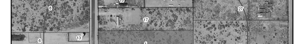
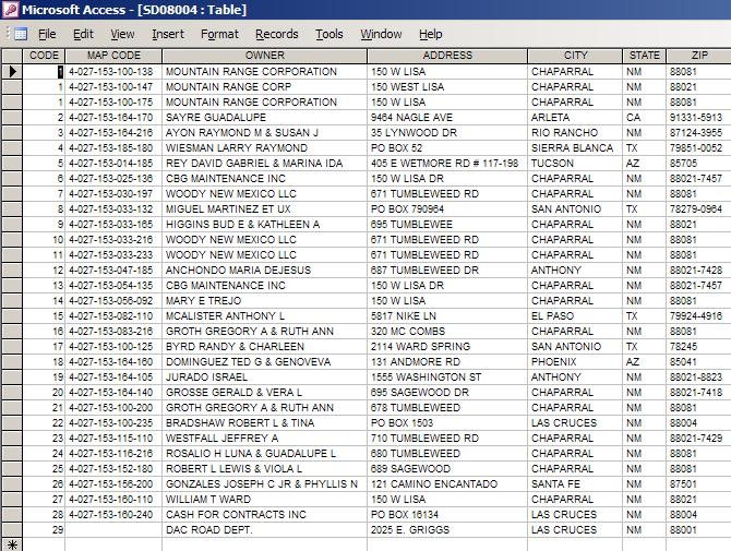
2 DOÑA ANA COUNTY COMMUNITY PLANNING AND ECONOMIC DEVELOPMENT DEPARTMENT Building Planning GIS 845 North Motel Boulevard Las Cruces, New Mexico (505) Fax: (505) Toll Free: 1 (877) TTY: (505) DOÑA ANA COUNTY PLANNING AND ZONING COMMISSION January 8, 2009 APPLICANT: Alex Wright OWNER: Mountain Range Corp. REQUEST: Preliminary Plat Approval for Tumbleweed Estates LOCATION: Tumbleweed Drive, Chaparral NM EXISTING ZONING: Performance District CASE ANALYSIS The Planning and Zoning Commission shall review and make recommendations for Approval, Conditional Approval or Denial of the following Preliminary Plat to the Board of County Commissioners (BOCC): Case # SD08-004: Submitted by Mountain Range Corporation a Type Three B Subdivision to be known as Tumbleweed Estates. The applicant is proposing 10 lots on 8.35 acres, ranging in size from acres to acres. Access will be on to Annett s Way, a 50 ft. right of way cul-desac with 28 of asphalt surfacing connecting on to Tumbleweed Drive a 60 ft. County right-ofway. Water will be provided by the CBG Water Company. Wastewater is by an approved New Mexico Environment septic system, solid waste disposal is available either from El Paso Disposal or Chaparral Disposal. All of the proposed lots meet the minimum lot size requirements. The developer / lot owners are to maintain drainage areas. The applicant is proposing dedication and maintenance of Annett s Way to the County if accepted by the BOCC, built to County Standards and is indicating all improvements will be in place prior to the recordation of the Final Plat. Approval or Conditional Approval of the Preliminary Plat shall constitute approval of the proposed subdivision design and layout of streets, lots, blocks and utilities, and shall be used as a guide in the preparation of the Final Plat. Staff is recommending Approval of the Preliminary Plat of Tumble Weed Estates. Characteristics of the Physical Site: Undisturbed natural desert landscape surrounded by residential development in a rural area. 2
3 AGENCY COMMENTS: State of New Mexico Office of the State Engineer (OSE): A positive opinion is issued. New Mexico Department of Transportation, Santa Fe: No further comments or concerns. New Mexico Environment Department: Applicant needs to submit the appropriate National Pollutant Discharge Elimination System (NPDES) permit prior to beginning construction. New Mexico Department of Cultural Affairs: Positive recommendation, there are no listed historic properties within the proposed subdivision. La Union Soil and Water: The subdivision will conform to the Doña Ana County Subdivision Regulations. CBG Water Company: The company is a New Mexico approved Water System and is ready, willing and able, to provide water service to the front of each lot within Tumbleweed Estates, see attached letter. Community Development Department: Staff received comment from the New Mexico Environment Department on January 5, 2009, stating that item 4 of the WATER QUANTITY AND AVAILABILITY PLAN is incorrect. The disclosure statement states a home larger than a three bedroom can be placed on the property with additional leach field, this is incorrect. It needs to state: a home larger than a three bedroom will require a non-discharging system or a ATU (Advanced Treatment System) with conventional disposal. Staff will have applicant make appropriate changes to the Disclosure Statement. County Engineering Department: All conditions have been met. County Flood Commission: Positive recommendation. DAC Fire Marshals: Positive recommendation. Fire flows are being met. County Building Services: No Building Permit is required from this office at this time. County Rural Addressing: Positive recommendation. Doña Ana County Utilities: The proposed sewer system will be extended into the area in Phase IV, we are in Phase 1B and do not expect to move into the area for another two years. The system extensions are dependent on funding. Community Notification: Signs were posted on the property. Las Cruces Sun News Legal Notification: Wednesday, December 17,
4 Twenty-nine letters of notification were sent out. As of January 2, 2009, two letters of response have been received. Mr. Humberto Martinez, responder, does not appear to be within the area of notification. Mr. Miguel Martinez is the second responder, who is identified as #8 on the notification list. See attached. PROPOSED FINDINGS AND STAFF RECOMMENDATIONS FOR TUMBLEWEED ESTATES PRELIMINARY PLAT The Planning and Zoning Commission hereby recommends to the Board of County Commissioners Approval of the Preliminary Plat for Tumbleweed Estates based on staff recommendations, the analysis and the following findings: 1. This application is consistent with the Doña Ana County Subdivision Regulations (Ordinance No , as amended), Articles 4 regarding procedures and requirements for the processing of Preliminary Plats. 2. The Doña Ana County Planning & Zoning Commission has jurisdiction to review this application. The property is outside of any incorporated municipal zoning authority and the Las Cruces Extra-Territorial Zone, and is within Doña Ana County. 3. This application is consistent with the Doña Ana County Land Use Regulations and Zoning Ordinance for PR-1 Low Intensity Residential as defined in the Performance District Standards. 4. The Tumbleweed Estates Preliminary Plats Data Requirements meet Section 4.5 of the Subdivision Ordinance for review by the Planning and Zoning Commission. 5. Staff recommended approval for Preliminary Plat Approval. 6. Approval Tumble Weed Estates is consistent with the goals and policies of the Doña Ana County Comprehensive Plan: a. Primary Goal 5: Allow for a variety of residential densities and housing types and a variety of minimum lot sizes to provide for rural, semi-rural and urban lifestyles. b. Primary Goal 6: Provide housing opportunities in rural and urban areas of the County that meet the needs of present and future populations in all socioeconomic groups. 4
5 5
6 6
7 To: Dona Ana County Planning and Zoning Commission Las Cruces, New Mexico Tuesday Dec 30, 2008 From: Humberto C. Martinez 670 Sagewood Drive Chaparral, New Mexico Dear Sirs A neighbor and friend of mine showed me the "Notice of A Public Meeting' he had received and asked me if I had also received on and planned to attend. I did not receive one, which prompts me to take issue with this. In seeing the notice I am prompted to raise numerous opposing arguments. 1) When I purchased my property in December 27, 1980, Delores Wright told me that the parcels could only be divided once, and only in half of their original size. I worked with Delores Wright in having her get elected for the Gadsden School Board and knew her on a personal basis. She often called me to translate for her with either her workers or other property owners. 2) The parcels of land that were divided into.75 acre lots were done only on Sunny Sands road and Edna Drive. This was also done by Delores Wright in order to provide low income people a place to also acquire land. The Streets of Sagewood and Tumbleweed were to be large tracts. Large tracts in order to allow each owner to have up to two (2) large animals like cows, steers, or horses. I myself had a cow and two steers at the same time. On all the other years, I had a horse. 3) The sewer treatment plant has come to Chaparral. This, in time, will force all property owners to hook up to it once it is installed in their street. Mountain Range Corporation will attempt to sell this lots with septic tanks. This is 'deceiving' to the buyers because they will soon have to pay the cost of the fees to connect to the sewer line. Which bring me to the next issue of contention. 4) Where did Mountain Range Corporation come from. In Chaparral there are only two (2) real estate groups. Colquitt and DeLara Estates. If this is approved, other owners in the Delara Estates subdivision should also be allowed to split their properties into.75 ac and.80 ac. Period. Please do not set a precedent. We purchased large lots because we wanted the open space of rural living. Not because we wished to live in a subdivision in El Paso, Anthony, or Las Cruces. There are numerous places where close living plots can be parceled out. Please do not destroy our peace and quiet. Smaller lots mean more density, more crime. Only those with less capital will buy a smaller lot, which is fine, but there are other areas where they can do this right now. Colquitt is developing such smaller lots on the East end of Chaparral. 5) I am totally opossed to this being done. This is underhanded, and defrauding to those who have been here such a long time. Something is not right in this. Does not seem right, does not smell good. It bodes ill for this to proceed. Humberto C. Martinez 7
8 28 Dec 2008 ATTN: Luis Marmolejo, (575) SUBJECT: Case # SD Mountain Range Corporation? Mr. Marmolejo, I have a lot of questions on a letter I received one week ago, on a proposed zoning change in Chaparral, ref case number stated above, which, if allowed, would be called "Tumbleweed Estates." 1. All reference lots in proposed zoning tract were originally owned by different individuals. What has happened to the original owners? WHO IS THE CURRENT OWNER OF "MOUNTAIN RANGE CORPORATION and the tracts, or parcel of land involved?" 2. When was "Mountain Range Incorporated?" And where? 3. When all these parcels were originally sold, in 5-acre, 10-acre, and larger tracts of land, it was with the written understanding that NONE of them could ever be subdivided into any parcel smaller than a 2.5-acre tract. So why are covenants of the original sale being violated? Not being honored and respected? Should remain a "Low Intensity Residential" zoning. People that prefer smaller lots can buy in other areas. 4. The original intent in the sale and development of this portion of Chaparral was for individuals to have 5-acre parcels, or larger. A few 2.5-acre tracts were sold, and were to remain that size. Only individual owners could subdivide their parcels. It was NEVER intended for one buyer, or corporation, to buy back several large parcels, then try to sneak them back into this sub-division as many tiny tracts of 0.75 acres to.0.80 acres. This is an underhanded, shady, and highly questionable method of conducting business. Makes me wonder if there may have been some under the table deals, or some still pending. Which leads me to the next two questions: 5. Why weren't ALL property owners within one-half mile of parcel in question not notified by mail of this proposed zoning change? 6. Why was such a short notification period given? Such actions should have a 90-day period for notification, questions, and public discussions. Note I say "discussions," not the singular "discussion." 7. What will be the impact on the area when sewage lines are constructed and every one with a house, trailer, etc is required to hook up and pay monthly fees? What are the estimated dates for this to take place? 8. I'm leery of this proposed zoning change. Doesn't pass the smell test. Too many red flags; far too many unanswered questions. With the limited information I have, I'm strongly opposed to the zoning change. If such a change would be allowed now, it could be repeated later in other parts of this sub-division, which is an outrageous violation of original covenant and promises made when parcels were originally sold. Request a response to above questions by close of business on 30 Dec I'll call Mr. Marmolejo tomorrow, Monday, 29th of Dec. If I cannot be at the annual business meeting of the ona ana county planning and zoning commission ( Thurs., 8 Jan 2009, 0900 hrs ), being held in Las Cruces, I'll ask one of my neighbors to attend. Miguel Martinez 8


9 9
10 10
11 11
12 12
13 13
14 14
15 15
16 16
17 17
18 18
19 19
20 20
21 21
22 22
23 23
24 24
25 25
26 26
27 27
28 28
29 29
30 30
31 31
32 32
33 33
34 34
35 35
36 36
37 37
38 38
39 39
40 40
COUNTY SUBDIVISION. Attachments: (1) Staff Analysis (2) Subdivision Maps (3) Related Documents including the Disclosure Statement
 Staff Analysis (2) Subdivision Maps (3) Related Documents including the Disclosure Statement") COUNTY SUBDIVISION DOÑA ANA COUNTY PLANNING AND ZONING COMMISSION Doña Ana County Government Center 845 N. Motel Blvd. Las Cruces, New Mexico 88007 Office: (575) 647-7250 MEETING DATE: August 25, 2011
COUNTY SUBDIVISION DOÑA ANA COUNTY PLANNING AND ZONING COMMISSION Doña Ana County Government Center 845 N. Motel Blvd. Las Cruces, New Mexico 88007 Office: (575) 647-7250 MEETING DATE: August 25, 2011
PLANNING AND ZONING COMMISSION
 DOÑA ANA COUNTY PLANNING AND ZONING COMMISSION Doña Ana County Annex Building 845 North Motel Boulevard Las Cruces, New Mexico 88007 Office: (575) 647-7237 MEETING DATE: July 22, 2010 CASE NO: PDR (H)
DOÑA ANA COUNTY PLANNING AND ZONING COMMISSION
 DOÑA ANA COUNTY Doña Ana County Government Complex 845 N. Motel Blvd. Las Cruces, New Mexico 88007 Office: (575) 647-7350 MEETING DATE: September 28, 2017 REQUEST: Preliminary Plat Approval for Vista Rancho
EXTRA TERRITORIAL ZONING COMMISSION CASE ANALYSIS. Elkhorn Land & Cattle Co., Shain Sproul, Agent
 DOÑA ANA COUNTY COMMUNITY PLANNING AND ECONOMIC DEVELOPMENT DEPARTMENT Building Planning GIS 845 North Motel Boulevard Las Cruces, New Mexico 88007 (575) 647-7350 Fax: (575) 525-6131 Toll Free: 1 (877)
CAMINO REAL REGIONAL UTILITY AUTHORITY EXTRA-TERRITORIAL PLANNING & ZONING COMMISSION
 CAMINO REAL REGIONAL UTILITY AUTHORITY EXTRA-TERRITORIAL PLANNING & ZONING COMMISSION DOÑA ANA COUNTY COMMUNITY DEVELOPMENT DEPARTMENT Doña Ana County Government Center 845 N. Motel Blvd. Las Cruces, New
EXTRA TERRITORIAL ZONING AUTHORITY CASE ANALYSIS
 DOÑA ANA COUNTY CASE # V09-007 COMMUNITY PLANNING AND ECONOMIC DEVELOPMENT DEPARTMENT Building Planning GIS 845 North Motel Boulevard Las Cruces, New Mexico 88007 (575) 647-7350 Fax: (575) 525-6131 Toll
EXTRA-TERRITORIAL ZONING AUTHORITY
 EXTRA-TERRITORIAL ZONING AUTHORITY DOÑA ANA COUNTY COMMUNITY DEVELOPMENT DEPARTMENT Doña Ana County Government Complex 845 North Motel Boulevard Las Cruces, New Mexico 88007 Office: (575) 647-7237 MEETING
EXTRA TERRITORIAL ZONING COMMISSION CASE ANALYSIS
 DOÑA ANA COUNTY CASE # Z07-011 COMMUNITY PLANNING AND ECONOMIC DEVELOPMENT DEPARTMENT Building Planning GIS 845 North Motel Boulevard Las Cruces, New Mexico 88007 (575) 647-7350 Fax: (575) 525-6131 Toll
PLANNING AND ZONING COMMISSION
 PLANNING AND ZONING COMMISSION DOÑA ANA COUNTY COMMUNITY DEVELOPMENT DEPARTMENT Doña Ana County Government Center 845 N. Motel Blvd. Las Cruces, New Mexico 88007 Telephone: (575) 647-7350 MEETING DATE:
PLANNING AND ZONING COMMISSION VARIANCE
 PLANNING AND ZONING COMMISSION VARIANCE DOÑA ANA COUNTY COMMUNITY DEVELOPMENT DEPARTMENT Doña Ana County Government Center 845 N. Motel Blvd. Las Cruces, New Mexico 88007 Telephone: (575) 647-7350 MEETING
PLANNING AND ZONING COMMISSION ZONE CHANGE
 PLANNING AND ZONING COMMISSION ZONE CHANGE DOÑA ANA COUNTY COMMUNITY DEVELOPMENT DEPARTMENT Doña Ana County Government Center 845 N. Motel Blvd. Las Cruces, New Mexico 88007 Telephone: (575) 647-7350 MEETING
EXTRA-TERRITORIAL ZONING AUTHORITY
 EXTRA-TERRITORIAL ZONING AUTHORITY DOÑA ANA COUNTY COMMUNITY DEVELOPMENT DEPARTMENT Doña Ana County Government Complex 845 North Motel Boulevard Las Cruces, New Mexico 88007 Office: (575) 647-7237 MEETING
PLANNING AND ZONING COMMISSION VARIANCE
 PLANNING AND ZONING COMMISSION VARIANCE DOÑA ANA COUNTY COMMUNITY DEVELOPMENT DEPARTMENT Doña Ana County Government Center 845 N. Motel Blvd. Las Cruces, New Mexico 88007 Telephone: (575) 647-7350 MEETING
PLANNING AND ZONING COMMISSION VARIANCE
 PLANNING AND ZONING COMMISSION VARIANCE DOÑA ANA COUNTY COMMUNITY DEVELOPMENT DEPARTMENT Doña Ana County Government Center 845 N. Motel Blvd. Las Cruces, New Mexico 88007 Telephone: (575) 647-7350 MEETING
DOÑA ANA COUNTY PLANNING AND ZONNING COMMISSION
 DOÑA ANA COUNTY PLANNING AND ZONNING COMMISSION Doña Ana County Government Complex 845 N. Motel Blvd. Las Cruces, New Mexico 88007 Office: (575) 647-7350 MEETING DATE: February 23, 2017 REQUEST: Zone Change
BELL COUNTY INFRASTRUCTURE REQUIREMENTS FOR MANUFACTURED HOME RENTAL COMMUNITIES
 BELL COUNTY INFRASTRUCTURE REQUIREMENTS FOR MANUFACTURED HOME RENTAL COMMUNITIES 1. Definitions: a. Manufactured Home-Means a structure falling within the definition of manufactured housing in Art. 5221f,
EXTRA TERRITORIAL ZONING AUTHORITY CASE ANALYSIS
 DOÑA ANA COUNTY CASE # Z09-001 COMMUNITY PLANNING AND ECONOMIC DEVELOPMENT DEPARTMENT Building Planning GIS 845 North Motel Boulevard Las Cruces, New Mexico 88007 (575) 647-7350 Fax: (575) 525-6131 Toll
DOÑA ANA COUNTY PLANNING AND ZONNING COMMISSION
 DOÑA ANA COUNTY PLANNING AND ZONNING COMMISSION Doña Ana County Government Complex 845 N. Motel Blvd. Las Cruces, New Mexico 88007 Office: (575) 647-7350 MEETING DATE: June 22, 2017 REQUEST: Variance CASE
Project File #: SF Project Name: Jackson Ranch Filing No. 4 Parcel Nos.: , and
 COMMISSIONERS: DARRYL GLENN (PRESIDENT) MARK WALLER (PRESIDENT PRO TEMPORE) STAN VANDERWERF LONGINOS GONZALEZ PEGGY LITTLETON PLANNING AND COMMUNITY DEVELOPMENT DEPARTMENT CRAIG DOSSEY, EXECUTIVE DIRECTOR
LARAMIE COUNTY PLANNING & DEVELOPMENT DEPARTMENT
 LARAMIE COUNTY PLANNING & DEVELOPMENT DEPARTMENT Planning Building MEMORANDUM TO: FROM: Laramie County Planning Commission Brad Emmons, Planning Director DATE: March 22, 2018 TITLE: Review and recommendations
City of Yelm. Community Development Department BOUNDARY LINE ADJUSTMENT OR LARGE LOT SUBDIVISION
 City of Yelm Community Development Department BOUNDARY LINE ADJUSTMENT OR LARGE LOT SUBDIVISION Fee Date Received By File No. FEES: Boundary Line Adjustment $100.00 LARGE LOT SUBDIVISION $250.00, + $10.00/lot
Conditional Use Permit / Standard Subdivision Application
 Conditional Use Permit / Standard Subdivision Application Name of Proposed Subdivision: Total Area (Acres) Is Proposed Subdivision to be built in phases? Number of Lots If yes, how many phases? Applicant/Owner
MS MINOR SUBDIVISION TREVITHICK
 MS-02-015 341.12 MINOR SUBDIVISION TREVITHICK A request by Danny Trevithick for a one-lot Minor Subdivision on five acres. The property is zoned A-35 (Agricultural) District and is located ¼ mile south
EXTRA TERRITORIAL ZONING COMMISSION CASE ANALYSIS
 DOÑA ANA COUNTY CASE # Z07-012 COMMUNITY PLANNING AND ECONOMIC DEVELOPMENT DEPARTMENT Building Planning GIS 845 North Motel Boulevard Las Cruces, New Mexico 88007 (575) 647-7350 Fax: (575) 525-6131 Toll
SPECIAL USE PERMIT EXTRA-TERRITORIAL ZONING COMMISSION
 SPECIAL USE PERMIT EXTRA-TERRITORIAL ZONING COMMISSION DOÑA ANA COUNTY COMMUNITY DEVELOPMENT DEPARTMENT Doña Ana County Government Complex 845 N. Motel Blvd., Las Cruces, New Mexico 88007 Office: (575)
OTTER TAIL COUNTY SANITATION CODE for SUBSURFACE SEWAGE TREATMENT SYSTEMS
 OTTER TAIL COUNTY SANITATION CODE for SUBSURFACE SEWAGE TREATMENT SYSTEMS Incorporating By Reference MINNESOTA RULES CHAPTERS 7080, 7081, AND 7082 With Some Local Modifications Effective Date: April 26,
Appendix A. Definitions
 Definitions 1. Terms Defined. Words contained in this are those having a special meaning relative to the purposes of this Ordinance. Words not listed in this section shall be defined by reference to: (1)
Group Sewer Only** 80 Ft Frontage* 20,000 Sq. Ft. (.46 acre) Minimum** 120 Ft Frontage* 20,000 Sq. Ft. (.46acre) Minimum** 150 Ft Frontage*
 Minimum** 120 Ft Frontage* 20,000 Sq. Ft. (.46acre) Minimum** 150 Ft Frontage*") Residential Lots Minimum Chart The minimum lot size of any minor subdivision where there is no public sewers shall be as shown below or as required by township zoning and/or the Tuscarawas General Health
Residential Lots Minimum Chart The minimum lot size of any minor subdivision where there is no public sewers shall be as shown below or as required by township zoning and/or the Tuscarawas General Health
Simple Land Division by Love and Affection - Application Checklist
 Simple Land Division by Love and Affection - Application Checklist Yes No A completed simple land division application form, with identification of property owner(s) for each lot. Fee per adopted fee schedule.
CHAPTER 3 PRELIMINARY PLAT
 10-3-1 10-3-3 SECTION: CHAPTER 3 PRELIMINARY PLAT 10-3-1: Consultation 10-3-2: Filing 10-3-3: Requirements 10-3-4: Approval 10-3-5: Time Limitation 10-3-6: Grading Limitation 10-3-1: CONSULTATION: Each
PRELIMINARY PLAT Checklist
 PRELIMINARY PLAT Checklist 3715 Bridgeport Way W University Place, WA 98466 PH: (253) 566-5656 FAX: (253) 460-2541 This is a checklist of materials required for a Preliminary Plat. This checklist is provided
Section SKETCH PLAN REVIEW
 Section 210 - SKETCH PLAN REVIEW 1. Within 30 days of receiving a complete application for a subdivision involving three or more lots, the Zoning Administrator shall refer the matter to the first available
ORDINANCE NO WHEREAS, no exceptions to applicable statewide planning goals numbers 2, 5, and 6 are proposed; and
 ORDINANCE NO. 203 AN ORDINANCE TO AMEND CHAPTER 157 WITHIN THE DUNES CITY CODE OF ORDINANCES ENTITLED "SEPTIC SYSTEM MAINTENANCE" AND REPEALING ORDINANCE NO. 173 WHEREAS, on March 09, 2006, the City Council
1 November 13, 2013 Public Hearing APPLICANT & PROPERTY OWNER: HOME ASSOCIATES OF VIRGINIA, INC.
 1 November 13, 2013 Public Hearing APPLICANT & PROPERTY OWNER: HOME ASSOCIATES OF VIRGINIA, INC. STAFF PLANNER: Carolyn A.K. Smith REQUEST: Conditional Change of Zoning (AG-1 & AG-2 Agricultural Districts
SECTION 10 STANDARD PLATS
 SECTION 10 - STANDARD PLATS Subdivision 1: Purpose Standard Plats allow the subdivision of land into lots smaller than the minimum metes and bounds size in the zoning district, and control road development
Southern NM State Fair & Rodeo PO Box 1145 Las Cruces, NM 88004
 Southern NM State Fair & Rodeo PO Box 1145 Las Cruces, NM 88004 January 1, 2017 Dear Potential Vendor, Each year the Southern New Mexico State Fair and Rodeo is host to over 22,000 people from Dona Ana,
LAURENS COUNTY MOBILE HOME PARK ORDINANCE ARTICLE 1 GENERAL
 LAURENS COUNTY MOBILE HOME PARK ORDINANCE ARTICLE 1 GENERAL 1.1 AUTHORITY AND JURISDICTION. The 1983 Georgia Constitution grants authority to the governing authority of the county to regulate land development
ARTICLE 800 PLANNED UNIT DEVELOPMENTS
 ARTICLE 800 PLANNED UNIT DEVELOPMENTS Sec. 00 Applicability of Planned Development regulations. Any owner of land within the jurisdiction of the City of Bentonville seeking approval of a Planned Unit Development
City of Nogales Planning & Zoning Commission Rezoning Application
 City of Nogales Planning & Zoning Commission Rezoning Application REZONING APPLICATION PROCEDURES 1450 N. Hohokam Nogales, Arizona 85621 Office (520) 285-5747 FAX (520) 287-6946 T.D.D. (520) The following
ZONE CHANGE EXTRA-TERRITORIAL ZONING COMMISSION
 ZONE CHANGE EXTRA-TERRITORIAL ZONING COMMISSION DOÑA ANA COUNTY COMMUNITY DEVELOPMENT DEPARTMENT Doña Ana County Government Complex 845 N. Motel Blvd. Las Cruces, New Mexico 88007 Office: (575) 647-7350
TOWN OF WILMINGTON DEVELOPMENT REVIEW BOARD FINDINGS OF FACT AND STATEMENT OF FINDINGS WILMINGTON, VERMONT 05363
 TOWN OF WILMINGTON DEVELOPMENT REVIEW BOARD FINDINGS OF FACT AND STATEMENT OF FINDINGS WILMINGTON, VERMONT 05363 A request for a permit was made to the Board by: Michael Kimack, Agent for Cold Brook Fire
All roads developed to access four (4) or more parcels shall be constructed to Park County Road and Bridge Standards.
 or more parcels shall be constructed to Park County Road and Bridge Standards.") P a r k C o u n t y P l a n n i n g a n d Z o n i n g 1002 Sheridan Avenue Cody, WY 82414 Phone: 307-527-8540 35-40 ACRE SUBDIVISIONS www.parkcounty.us/planandzone.htm May 2011 This is only intended as
P a r k C o u n t y P l a n n i n g a n d Z o n i n g 1002 Sheridan Avenue Cody, WY 82414 Phone: 307-527-8540 35-40 ACRE SUBDIVISIONS www.parkcounty.us/planandzone.htm May 2011 This is only intended as
Special Use Permit Application & Process See Unified Development Code
 Special Use Permit Application & Process See Unified Development Code 18.40.100 Public Works Planning Division PO Box 768 100 E. Santa Fe Street Olathe, Kansas 66051 P: 913-971- 8750 F: 913-971-8960 www.olatheks.org
Angola by the Bay POA, Inc. Restrictive Covenants - Absentee Ballot
 Angola by the Bay POA, Inc. Restrictive Covenants - Absentee Ballot DIRECTIONS 1. Fill out Absentee Ballot on pages 2 through 6 completely. 2. Check off either [ ] Yes, I accept the proposed changes or
Eddy County Affordable Housing Plan Executive Summary July 2015
 1 Eddy County Affordable Housing Plan Executive Summary All of Eddy County is experiencing a serious housing shortage due to an influx of new labor working in the oil and gas fields. During the latest
Chapter 100 Planned Unit Development in Corvallis Urban Fringe
 100.100 Scope and Purpose. Chapter 100 Planned Unit Development in Corvallis Urban Fringe (1) All applications for land divisions in the Urban Residential (UR) and Flood Plain Agriculture (FPA) zones within
LARAMIE COUNTY PLANNING & DEVELOPMENT DEPARTMENT
 LARAMIE COUNTY PLANNING & DEVELOPMENT DEPARTMENT Planning Building MEMORANDUM TO: FROM: Laramie County Planning Commission Brett Walker, Planner DATE: January 25, 2018 TITLE: Review and action of a Subdivision
Residential Subdivision Preliminary Plat Application
 WATER MODELING FEES Major : $650 or Minor : $550 # of lots x $35 per lot Residential Preliminary Plat Application Lots: 1-9 10-19 20-49 50-99 100-199 $300 $400 $475 $625 $825 200-349 350-499 500-499 700-999
Concho Wastewater Improvement District ( District ) Customer Rules and Regulations
 Customer Rules and Regulations") Concho Wastewater Improvement District ( District ) Customer Rules and Regulations Approved 5/27/17 1.0 Establishment of Service 1.1 To receive wastewater service from the District, a landowner must execute
Concho Wastewater Improvement District ( District ) Customer Rules and Regulations Approved 5/27/17 1.0 Establishment of Service 1.1 To receive wastewater service from the District, a landowner must execute
Guide to Permitting Town of Groton, MA
 Guide to Permitting Town of Groton, MA Introduction The purpose of this guidebook is to assist homeowners, property and business owners, developers, brokers and contractors who want to develop land within
610 LAND DIVISIONS AND PROPERTY LINE ADJUSTMENTS OUTSIDE A UGB
 ARTICLE VI: LAND DIVISIONS AND PROPERTY LINE ADJUSTMENTS VI-21 610 LAND DIVISIONS AND PROPERTY LINE ADJUSTMENTS OUTSIDE A UGB 610-1 Property Line Adjustments (Property Line Relocation) A property line
THOMPSON-NICOLA REGIONAL DISTRICT INFORMATION TO APPLICANTS MANUFACTURED HOME PARK/ MANUFACTURED HOME PARK EXTENSION
 THOMPSON-NICOLA INFORMATION TO APPLICANTS MANUFACTURED HOME PARK/ MANUFACTURED HOME PARK EXTENSION All requests for a manufactured home park/manufactured home park extension must be accompanied by the
Application for Preliminary Plat Checklist
 Application for Preliminary Plat Checklist Note: No portion of an existing parcel may be sold or transferred to another party without first legally subdividing the property according to the City of Richmond
1. The reason provided for the opposing votes was that the two commissioners wanted something else to be developed on their parcel.
 Agenda Item #6.2 SUBJECT: PUBLIC HEARING - APPEAL OF PLANNING COMMISSION DECISION DENYING THE APPROVAL OF THE TENTATIVE PARCEL MAP, CONDITIONAL USE PERMIT, AND SITE AND ARCHITECTURAL REVIEW FOR THE CONSTRUCTION
TO: Glynn County Islands Planning Commission. Eric Landon, Planner II. PP2754 Stones Throw Cottages. DATE: February 6, 2014
 COMMUNITY DEVELOPMENT DEPARTMENT Planning and Zoning Division 1725 Reynolds Street, Suite 200, Brunswick, GA 31520 Phone: 912-554-7428/Fax: 1-888-252-3726 TO: Glynn County Islands Planning Commission FROM:
Preliminary Plat Application & Submittal Checklist
 Planning & Community Development Department 550 Landa Street New Braunfels, Texas 78130 (830) 221-4050 www.nbtexas.org Preliminary Plat Application & Submittal Checklist Applicant Name: *Signature. * By
NOTICE OF THE REGULAR MEETING OF THE PLANNING & ZONING COMMISSION Tuesday, April 4, 2017 REGULAR MEETING AGENDA 6:30 PM
 NOTICE OF THE REGULAR MEETING OF THE PLANNING & ZONING COMMISSION Tuesday, April 4, 2017 Notice is hereby given of the Regular Meeting of the Planning & Zoning Commission beginning at 6:30 p.m. Tuesday,
I. Requirements for All Applications. C D W
 108-16.1. Application checklists. Checklist for Required Submissions to the Planning Board or Zoning Board of Adjustment of Monroe Township All required submissions are to be made to the Administrative
APPLICATION FOR SUBDIVISION APPROVAL Summary of Application Review & Approval Process and Application Form April 1, 2009
 Land Planning Branch, (K-320LP) Phone 667-8877 Fax 393-6340 APPLICATION FOR SUBDIVISION APPROVAL Summary of Application Review & Approval Process and Application Form April 1, 2009 THE SUBDIVISION APPLICATION,
CITY OF SARALAND PRELIMINARY SUBDIVISION PLAT REVIEW
 PRELIMINARY SUBDIVISION PLAT REVIEW Application Number: Date Plat Submitted: Name of Subdivision: Name of Owner: Owner Address: (Street or P.O. Box) Telephone #: (City) (State) (Zip) E-mail: Name of Authorized
SPECIAL SERVICE AREA DISCLOSURE
 SPECIAL SERVICE AREA DISCLOSURE All lots within this subdivision are included within the County of Will Special Service Area Number and are subject to an annual tax levy in accordance with the provisions
Attached is a Clinton Township Zoning Permit Application and requirements for issuance of a permit.
 To Whom It May Concern: Attached is a Clinton Township Zoning Permit Application and requirements for issuance of a permit. The fee for the permit application is $75.00, which shall be made payable to
STATE OF MICHIGAN COUNTY OF MARQUETTE, TOWNSHIP OF NEGAUNEE LAND DIVISION, SUBDIVISION AND CONDOMINIUM ORDINANCE
 STATE OF MICHIGAN COUNTY OF MARQUETTE, TOWNSHIP OF NEGAUNEE LAND DIVISION, SUBDIVISION AND CONDOMINIUM ORDINANCE Adopted: August 8 th, 2008 Effective: August 28 th, 2008 Sec.100. Title ARTICLE I GENERAL
STATE OF SOUTH CAROLINA ) ) ESCROW AND OPERATION AGREEMENT COUNTY OF GREENWOOD ) This agreement made and entered this day of, 200, by and between
 ) ESCROW AND OPERATION AGREEMENT COUNTY OF GREENWOOD ) This agreement made and entered this day of, 200, by and between") STATE OF SOUTH CAROLINA ) ) ESCROW AND OPERATION AGREEMENT COUNTY OF GREENWOOD ) This agreement made and entered this day of, 200, by and between Terrapin Pointe Property Owners Association, Inc., hereinafter
STATE OF SOUTH CAROLINA ) ) ESCROW AND OPERATION AGREEMENT COUNTY OF GREENWOOD ) This agreement made and entered this day of, 200, by and between Terrapin Pointe Property Owners Association, Inc., hereinafter
Bethel Romanian Church - Rezone, RZ
 / Planning and Zoning Staff Report Bethel Romanian Church - Rezone, RZ2018-0023 Hearing Date: November 15, 2018 Development Services Department Owners: Bethel Romanian Church, Corp. Applicant: Viorel Botos
APPLICATION PROCEDURE
 ANTRIM PLANNING BOARD P. O. Box 517 Antrim, New Hampshire 03440 Phone: 603-588-6785 FAX: 603-588-2969 APPLICATION FORM AND CHECKLIST FOR MINOR OR MAJOR SITE PLAN REVIEW File Date Received By APPLICATION
KLICKITAT COUNTY CODE Chapter RECREATIONAL VEHICLE PARKS
 KLICKITAT COUNTY CODE Chapter 22.08 - RECREATIONAL VEHICLE PARKS 22.08.010 - Applicability. Every recreational park in the unincorporated area of the county shall be located, constructed, altered, expanded
Legal Description Part of the Western Half of the Eastern Half of the Northwest Quarter of Section 30, Le Ray Township
 Owner and Applicant s 20448 State Highway 83 Mankato, MN 56001 Request and Location Request for review and approval of a Conditional Use Permit to allow an Elder Care Residential Unit to be constructed
BOUNDARY LINE ADJUSTMENT
 DEPARTMENT OF COMMUNITY DEVELOPMENT 621 Sheridan Street, Port Townsend, WA 98368 Tel: 360.379.4450 Fax: 360.379.4451 Web: www.co.jefferson.wa.us/communitydevelopment E-mail: dcd@co.jefferson.wa.us BOUNDARY
ARTICLE 15. RULES, REGULATIONS AND DEFINITIONS
 ARTICLE 15. RULES, REGULATIONS AND DEFINITIONS Section 1. Interpretation and Construction: The following rules and regulations regarding interpretation and construction of the Ulysses-Grant County, Kansas,
WASHINGTON COUNTY CUP SUBMITTAL CHECKLIST
 WASHINGTON COUNTY CUP SUBMITTAL CHECKLIST The following must be turned in to the Planning Office by the submittal date for your CUP to be reviewed by the Planning Board. (Incomplete applications will not
El Paso County Development Review System Adopted Fee Schedule (2005)
") Special Districts Special District 5 (multiple districts for the same project is one fee) D $6,300 Special District Amendment 5 D $3,950 Master Plans Master Plan, Master Plan Amendment D $11,900 Land Use
Special Districts Special District 5 (multiple districts for the same project is one fee) D $6,300 Special District Amendment 5 D $3,950 Master Plans Master Plan, Master Plan Amendment D $11,900 Land Use
FRANKLIN COUNTY PLANNING BOARD. April 12, 2016
 FRANKLIN COUNTY PLANNING BOARD April 12, 2016 The Franklin County Planning Board held its regular monthly meeting on Tuesday, April 12, 2016 in the Franklin County Administration Building, Commissioners
WESTON COUNTY FINAL PLAT APPLICATION
 WESTON COUNTY FINAL PLAT APPLICATION Property Owner: Mailing Address of owner: Telephone Number(s) of owner: Property Owner: Mailing Address of owner: Telephone Number(s) of owner: (If subdivider/applicant
The City of MIDWEST CITY 100 N. Midwest Blvd * Midwest City, Oklahoma (405) *TDD (405) * FAX (405)
 *TDD (405) * FAX (405)") The City of MIDWEST CITY 100 N. Midwest Blvd * Midwest City, Oklahoma 73110 (405) 739-1210 *TDD (405) 739-1286 * FAX (405) 739-1399 Receipt # Date Inspection Date: PROPOSED OCCUPANCY Application for Certificate
The City of MIDWEST CITY 100 N. Midwest Blvd * Midwest City, Oklahoma 73110 (405) 739-1210 *TDD (405) 739-1286 * FAX (405) 739-1399 Receipt # Date Inspection Date: PROPOSED OCCUPANCY Application for Certificate
APPLICATION FOR PRELIMINARY PLAT CERRO GORDO COUNTY, IOWA
 APPLICATION FOR PRELIMINARY PLAT CERRO GORDO COUNTY, IOWA Before subdividing any tract of land and previous to the filing of an Application for conditional approval of the Preliminary Plat, the subdivider
Guide to Combined Preliminary and Final Plats
 Guide to Combined Preliminary and Final Plats Introduction The Douglas County is committed to providing open, transparent application processes to the public. This Guide is provided to assist anyone interested
CHAPTER 14 SPECIAL DEVELOPMENTS
 10-14-1 10-14-1 CHAPTER 14 SPECIAL DEVELOPMENTS SECTION: 10-14-1: Cluster and Inner Block Development 10-14-2: Planned Unit Development 10-14-1: CLUSTER AND INNER BLOCK DEVELOPMENT: A. Land Use: Cluster
TO: Glynn County Mainland Planning Commission. Eric Lee Johnson, Planning Division Manager. PP2944 McKenzie Gardens. DATE: November 20, 2014
 MEMO COMMUNITY DEVELOPMENT DEPARTMENT Planning and Zoning Division 1725 Reynolds Street, Suite 200, Brunswick, GA 31520 Phone: 912-554-7428/Fax: 1-888-252-3726 TO: Glynn County Mainland Planning Commission
APPLICATION FOR FINAL PLAT APPROVAL
 APPLICATION FOR FINAL PLAT APPROVAL Section 1. General. The undersigned Applicant (Applicant is synonymous with owner) makes this Application for Final Plat Approval in accordance with Chapter 21, Port
13-2 SUBDIVISION PLANS AND PLATS REQUIRED EXCEPTIONS Subdivision Plats Required To be Recorded
 ARTICLE XIII SUBDIVISIONS 13-1 INTENT AND PURPOSE 13-1-1 Intent: It is the intent of the County Commission through the adoption of this Article to more fully avail itself of the power granted under 17-27-601
PRELIMINARY ZONING COMPLIANCE REPORT
 PRELIMINARY ZONING COMPLIANCE REPORT Apple Tree Shopping Center 123 Subject Street Albuquerque, NM 87101 Prepared for: ABC Capital Dated: September 29, 2015 Global Zoning Job #: 123456 Client Reference
Town of Shelburne, Vermont
 Town of Shelburne, Vermont CHARTERED 1763 P.O. BOX 88 5420 SHELBURNE ROAD SHELBURNE, VT 05482 www.shelburnevt.org 802-985-5118 * * Also available in alternate formats in accordance with the Americans With
Pocono Springs Civic Association Architectural Rules and Regulations. Adopted by Board of Directors Date: January 20, 2007
 Pocono Springs Civic Association Architectural Rules and Regulations Adopted by Board of Directors Date: January 20, 2007 1) Purpose of Architectural Rules and Regulations Is to preserve an informal, natural,
FREQUENTLY ASKED QUESTIONS about on-site wastewater (septic) systems. I want to build a new home served by a septic system. What do I need to do?
 systems. I want to build a new home served by a septic system. What do I need to do?") FREQUENTLY ASKED QUESTIONS about on-site wastewater (septic) systems CONTENTS: Part One: New Construction, Adding Bedrooms Part Two: Buying and Selling Property Part Three: Complaints and Enforcement Part
FREQUENTLY ASKED QUESTIONS about on-site wastewater (septic) systems CONTENTS: Part One: New Construction, Adding Bedrooms Part Two: Buying and Selling Property Part Three: Complaints and Enforcement Part
SAULT STE. MARIE NORTH PLANNING BOARD APPLICATION FOR A CONSENT TO CREATE NEW LOTS
 SAULT STE. MARIE NORTH PLANNING BOARD APPLICATION FOR A CONSENT TO CREATE NEW LOTS APPLICATION GUIDE Q & A These tips are intended as a guide to help you decide if your proposed lot might qualify for a
EXTRA TERRITORIAL ZONING COMMISSION CASE ANALYSIS
 DOÑA ANA COUNTY CASE # Z08-009 COMMUNITY PLANNING AND ECONOMIC DEVELOPMENT DEPARTMENT Building Planning GIS 845 North Motel Boulevard Las Cruces, New Mexico 88007 (575) 647-7350 Fax: (575) 525-6131 Toll
SARPY COUNTY BOARD OF ADJUSTMENT MINUTES OF MEETING May 14, 2015
 l. CALL MEETING TO ORDER SARPY COUNTY BOARD OF ADJUSTMENT MINUTES OF MEETING May 14, 2015 A meeting of the Board of Adjustment of Sarpy County, Nebraska was convened in open and public session at the call
What is a Conditional Use? When is a Conditional Use Necessary? Who decides if I will get a Conditional Use Permit
 What is a Conditional Use? A conditional use is a land use or development that would not be appropriate generally but may be allowed with appropriate controls upon a finding that certain conditions as
County of San Bernardino Department of Public Health Environmental Health Services
 County of San Bernardino Department of Public Health Environmental Health Services INSTRUCTIONS FOR COMPLETING THE D.E.H.S SEWAGE HOLDING TANK APPLICATION San Bernardino County has adopted a procedure
YELLOWSTONE COUNTY BOARD OF PLANNING FINDINGS OF FACT
 YELLOWSTONE COUNTY BOARD OF PLANNING FINDINGS OF FACT The City-County Planning staff has prepared the Findings of Fact for the Aspen Ridge Subdivision, 2 nd Filing. These findings are based on the preliminary
NYE COUNTY, NV PAHRUMP REGIONAL PLANNING COMMISSION REGULAR MEETING December 14, 2016
 NYE COUNTY, NV PAHRUMP REGIONAL PLANNING COMMISSION REGULAR MEETING December 14, 2016 Staff Report Agenda Item No. 13 CASE DESCRIPTION(S): LOCATION: For Possible Action CU-2016-000023: Public hearing,
CITY OF SARALAND FINAL SUBDIVISION PLAT REVIEW
 CITY OF SARALAND FINAL SUBDIVISION PLAT REVIEW Application Number: Date Plat Submitted: Name of Subdivision: Name of Owner: Owner Address: (Street or P.O. Box) Telephone #: (City) (State) (Zip) E-mail:
EDMOND PLANNING COMMISSION MEETING. Tuesday, October 5, 2004
 124 EDMOND PLANNING COMMISSION MEETING Tuesday, 5:30 P.M. The Edmond Planning Commission Meeting was called to order by Chairperson David Woods at 5:30 p.m., Tuesday,, in the City Council Chambers at 20
APPLICATION FOR CONSENT TO SEVER LAND UNDER SECTION 53 OF THE PLANNING ACT
 APPLICATION FOR CONSENT TO SEVER LAND UNDER SECTION 53 OF THE PLANNING ACT The Cochrane and Suburban Planning Board 23 5th Street Cochrane, Ontario P0L 1C0 Phone (705 272-4262 Fax (705 272-4507 APPLICATION
CHECKLIST FOR DEVELOPMENT REVIEW
 CHECKLIST FOR DEVELOPMENT REVIEW Petitions and related documents and plans for land development or other proposals regulated by Title 16 of the Municipal Code (Development Ordinance) and Title 17 of the
A. Preserve natural resources as identified in the Comprehensive Plan.
 1370.08 Conservation Residential Overlay District. Subd. 1 Findings. The City finds that the lands and resources within the Conservation Residential Overlay District are a unique and valuable resource
APPLICATION FOR PRELIMINARY PLAT RESIDENTAIL. FILING FEE: $ for the first 20 lots; $10.00 for each additional lot over 20
 COMMUNITY PLANNING & DEVELOPMENT TELEPHONE.* (816) 331-4331 FAX * (816) 331-6973 CITY HALL ANNEX 520 MAIN STREET BELTON, MISSOURI 64012 WEBSITE * www.belton.org APPLICATION FOR PRELIMINARY PLAT RESIDENTAIL
TOWN OF DUCK PLANNING BOARD REGULAR MEETING. October 9, The Planning Board for the Town of Duck convened at the Duck Meeting Hall on Wednesday,
 TOWN OF DUCK PLANNING BOARD REGULAR MEETING October 9, 2013 The Planning Board for the Town of Duck convened at the Duck Meeting Hall on Wednesday, October 9, 2013. Present were: Chair Joe Blakaitis, Vice
REZONING APPLICATION INSTRUCTIONS
 REZONING APPLICATION INSTRUCTIONS All required information, as stated on the Rezoning Application Checklist, must be included to qualify as a complete application. Upon receipt, staff will review the application