Metro log y for Archaeo log y
|
|
|
- Theodora Maxwell
- 6 years ago
- Views:
Transcription


1 1 st International Conference on Metro log y for Archaeo log y PROCEEDINGS VOLUME I
2 Proceedings of the 1st International Conference on Metrology for Archaeology Benevento - Italy - October 21-23, 2015 ISBN All rights reserved. No part of this publication may be reproduced in any form, nor may it be stored in a retrieval system or transmitted in any form, without written permission from the copyright holders
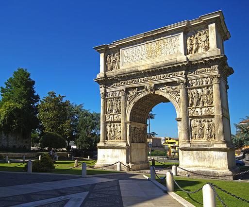
3 Welcome to 1st International Conference on Metrology for Archaeology On behalf of the organizing committee, we cordially welcome you to the 1st International Conference on Metrology for Archaeology (MetroArcheo). The growing interest of archaeological sciences to new technologies and analysis techniques, has recently improved the combined use of numerical approach and metrology systems to get more detailed archaeological purpose. For example, advances in computer science, data acquisition and modeling, new spectrometric techniques, analysis and remote sensing have encouraged interactions among these scientific disciplines based on measurement data and archaeological interpretations. The benefits of a multidisciplinary approach have reduced the level of uncertainty in archaeological studies. The 1st International Conference on Metrology for Archaeology involve researchers and practitioners interested in the enhancement, characterization and conservation of the archaeological heritage, with the main objective to focus the discussion on the production, interpretation and the reliability of the measured data. The meeting was designed to give the community of archaeologists a complete picture of knowledge of the "fit" of the archaeological heritage, generally addressed in several conferences with restricted areas of interest. The first edition of MetroArcheo will be held in Benevento, a small town in Southern Italy with a significant historical heritage. It was a base for Roman expansion in Southern Italy and an important stop on the Appian Way, the ancient Roman road connecting the West and East coasts. After being sacked in 452, Benevento was ruled by the Lombards (or Longobards) and Byzantines, and finally by the Pope who ruled the town for 800 years. Benevento, in a beautiful setting in the hills, is a pleasant place to visit, a good break from the heavily touristic areas near Naples and the Amalfi Coast and a chance to experience the feel of a Southern Italian town. Visiting Benevento is like a journey through history: the prehistoric and the Egyptian finds at the Museum of Sannio, Traiano s Arch and the Roman theatre, the Dome and the Church of Santa Sofia of Longobardian times, the undergrounds of the Prefectural Palace that hosts ARCOS, the contemporary art museum. Benevento is included, for the Santa Sofia Complex, in the UNESCO World Heritage Sites for The Longobards in Italy, Places of Power, A.D.. It comprises seven groups of important buildings (including fortresses, churches, and monasteries) throughout the Italian Peninsula. They testify to the high achievement of the Lombards, who migrated from Northern Europe and developed their own specific culture in Italy where they ruled over vast territories in the 6th to 8th centuries. We are sure that the universally recognized historical beauty of Benevento will be a perfect frame for this prestigious conference. It is, in fact, a further occasion, not only to meet old friends and new people from all over the world, but, moreover, to engage with them a continuous comparison directed to make wider the views on the technological progress of Metrology for Archaeology. The MetroArcheo organization was a complex task due to the large and increasing interest of our research and application areas. Efforts from many people were required to shape the technical program, arrange accommodation, manage the administrative aspects, and set up the social functions. We like to take this opportunity to thank all and each of them. We like also to thank the public and private organizations that supported the meeting in different ways. The MetroArcheo Technical Program consists of 17 oral and poster sessions scheduled over two days. With the wide range of technical sessions covering the many fields of metrology for archaeology we are happy to welcome you to the variety of technical presentations that await you this year. Thanks to all of the Technical Program Committee members and the reviewers who have contributed to make this outstanding program possible. We received 152 abstracts from all over the world. The technical program encompasses several events and activities. The keynote speeches will be held by experts in the field of metrology for archeology; Prof. Massimo Osanna, Soprintendenza speciale per i Beni Archeologici di Pompei, Ercolano e Stabia, will speak about Contexts and Objects, Prof. Jean- Pierre Brun, Collège de France France, will present the Archaeology of Production, Prof. Hans-Arno Synal,


4 ETH Zurich Switzerland, will describe the Progress in Accelerator Mass Spectrometry. We are honored to have them as plenary speakers and thank them in advance for coming to our conference to share their knowledge and experiences with us. Furthermore, attendees have the possibility to follow a half day of Tutorials organized and managed by Soprintendenza Archeologia della Campania. The tutorials include discussions and visit at Arch of Trajan and Sant'Ilario Church with Museum of the Arch, Archaeological Area of Arco del Sacramento, Cathedral's Hypogeum, Roman Theatre and Ponte Leproso. With the aim of providing a common ground for researches to share their findings about the metrology for archaeology, the conference includes a significant number of Special Sessions. A first reason is that so many are the application fields of the metrology for archaeology that a single track could have been too much dispersive. A second reason is that, in spite of a centralized research address definition, a spontaneous aggregation of well-focused themes has been gathered, with specific aim of providing a forum of dedicated debate very close to the single research field. Therefore, several application-oriented Special Sessions have been organized. We wish to thank the organizers of these Special Sessions for their cooperation and support to the conference organization. Several Awards will be assigned, in particular to young researchers. The 1st International Conference on Metrology for Archaeology is about to begin. You are now in a position to enjoy the fellowship of colleagues and experts and to pass free time in natural and artistic beauties. It is up to you to appreciate the conference worth! Be critical! We, metrologists, archaeologists, geologists, colleagues, and friends, all know that this is the best way to improve quality, and to achieve lasting excellences. General Co-Chair Adele CAMPANELLI, Soprintendenza Archeologia della Campania, Italy General Co-Chair Luca CERCHIAI, University of Salerno, Italy General Co-Chair Pasquale DAPONTE, University of Sannio, Italy General Co-Chair Alessio LANGELLA University of Sannio, Italy

5 Welcome Message from the Mayor of Benevento I am glad to give my welcome to all participants at the First International Conference on Metrology for Archeology, in collaboration with the University of Sannio. My thanks go especially to Professor Pasquale Daponte and Professor Alessio Langella who have decided to make this conference in our wonderful City, Benevento. About the event that will take place in these days, the presence in our Sannio of so many researchers and scientists from every part of the world is a source of pride and trust for our city and I wish to express heartfelt gratitude also to all the people from the University of Sannio who have been involved in the organization of the event. As Major of Benevento I am very proud to have a significant event like this in our City and I really hope all of you will get the occasion to visit our City. Benevento, besides being a university city, it has also a remarkable entrepreneurial vitality in the areas of technological innovation. I would like to emphasize that our city in the Campania region is one with the highest number of production sites in the advanced tertiary sector. For this we must thank the vitality of young graduates who have invested their expertise at the service of the territory with startups and spinoff. Besides this, I have to underline that the city of Benevento has a huge historical, monumental and architectural fortune, and with the complex of Santa Sofia Church has obtained UNESCO recognition entering in the World Heritage Lists in The enhancement of our cultural heritage has allowed us in recent years to achieve this important goal in a clear manner that testifies not only that Benevento is a town rich in places of art and history, but also that we are taking the right strategy to valorize and enhance our heritage. Important events, such as this Conference on Metrology for Archeology, represent the right opportunity to call attention to internal areas of Campania region, and above all to our beautiful city Benevento and wonderful Sannio. The conference will be surely a moment of scientific investigation and a good opportunity to offer useful discussion among scientists working in this important field. I wish a good job to all the participants and organizers for these two days. Fausto Pepe
6 MetroArcheo 2015 Committee GENERAL CHAIRS Adele Campanelli, Soprintendenza Archeologia della Campania, Italy Luca Cerchiai, University of Salerno, Italy Pasquale Daponte, University of Sannio, Italy Alessio Langella, University of Sannio, Italy TECHNICAL PROGRAM CO-CHAIRS Celestino Grifa, University of Sannio, Italy Carmine Lubritto, Second University of Naples, Italy Mariano Mercurio, University of Sannio, Italy Alfonso Santoriello, University of Salerno, Italy Luigina Tomay, Soprintendenza Archeologia della Campania, Italy INTERNATIONAL PROGRAM COMMITTEE Emma Angelini, Politecnico di Torino, Italy Giovanni Azzena, University of Sassari, Italy Salvatore Barba, University of Salerno, Italy José Antonio Barrera Vera, University of Seville, Spain Luca Bondioli, University of Naples L'Orientale, Italy Jean-Pierre Brun, Collège de France, France Gert - Jan Burgers, VU University Amsterdam, Netherlands Lucio Calcagnile, University of Salento, Italy Franco Cambi, University of Siena, Italy Stefano Campana, University of Siena, Italy Piergiulio Cappelletti, University of Naples Federico II, Italy Massimo Carpinelli, University of Sassari, Italy Andrea Cataldo, University of Salento, Italy Giuseppe Cultrone, University of Granada, Spain Egidio De Benedetto, University of Salento, Italy Claudio De Capua, University Mediterranea of Reggio Calabria, Italy Hélène Dessalles, Ecole Normale Supérieure, France Christian Fischer, UCLA/Getty Conservation IDP, USA Venice Gouda, National Research Centre (NRC), Egypt Sabrina Grassini, Politecnico di Torino, Italy Maria Iacovou, University of Cyprus, Cyprus Giovanni Leucci, National Research Council - Istituto per i Beni Archeologi e Monumentali, Italy Lara Maritan, University of Padova, Italy Vincenzo Morra, University of Naples Federico II, Italy Priscilla Munzi, Centre Jean Bérard, France Marco Parvis, Politecnico di Torino, Italy Alessandra Pecci, University of Barcellona, Spain Salvatore Piro, National Research Council, Italy Gianluca Quarta, University of Salento, Italy Juan Antonio Quirós Castillo, University of Pais Vasco, Spain
7 Fabio Remondino, Fondazione Bruno Kessler, Italy Marco Rendeli, University of Sassari, Italy Carmen Maria Rosskopf, University of Molise, Italy Elda Russo Ermolli, University of Naples Federico II, Italy Maria Rosaria Senatore, University of Sannio, Italy Emanuela Sibilia, University of Milano Bicocca, Italy Martijn Van Leusen, University of Groningen, Netherland Panayota Vassiliou, National Technical University of Athens (NTUA), Greece LOCAL COMMITTEE Chiara Germinario, University of Sannio, Italy Francesco Izzo, University of Sannio, Italy Gianluca Mazzilli, University of Sannio, Italy Daniela Musmeci, University of Salerno, Italy Carmine Sementa, University of Sannio, Italy Giusy Sica, University of Salerno, Italy Liliana Viglione, University of Sannio, Italy Marianna Vigorito, University of Salerno, Italy LOCAL ARRANGEMENTS


8 MetroArcheo 2015 Keynote Speakers Massimo Osanna Soprintendenza speciale per i Beni Archeologici di Pompei, Ercolano e Stabia Keynote Thursday, October 22nd, 2015 "Contexts and Objects" Jean-Pierre Brun Collège de France Keynote Friday, October 23rd, 2015 "Archaeology of production" Hans-Arno Synal ETH Zurich Keynote Friday, October 23rd, 2015 "Progress in Accelerator Mass Spectrometry"


9 MetroArcheo 2015 Academic Patronage University of Sannio University of Salerno Research Institute for the Heritage and History of the Cultural Landscape and Urban Environment - VU University University of Salento University of Sassari Politecnico di Torino MetroArcheo 2015 Institutional Patronage Prefettura di Benevento Provincia di Benevento Comune di Benevento KNIR Centre Jean Bérard CIPA


10 ICOMOS IBAM Fondazione Bruno Kessler Scuola di specializzazione in beni archeoligici "Dinu Adamesteanu" CEDAD Club UNESCO Benevento Gruppo Misure Eletriche Elettroniche Group of Mechanical and Thermal Measurements Distretto ad Alta Tecnologia dei Beni Culturali Ancient Appia Landscapes Società Italiana di Mineralogia e Petrologia Istituto di Metodologie per l Analisi Ambientale - CNR Georisorse, Ambiente e Beni Culturali Ordine dei Geologi della Campania


11 MetroArcheo 2015 Sponsors BRUKER CENTRO DI ATENEO PER L ORIENTAMENTO E IL TUTORATO ASSING
12
13 1st International Conference on Metrology for Archaeology Benevento, Italy, October 22-23, 2015 Arpi: measure the forms of an Italiote city (4th 2nd centuries BC) Munzi Pr.1, Pouzadoux Cl.1, Santoriello A.2, Terribile A.2, Muntoni I.M.3, Capozzoli L. 4, De Martino G.4, Giampaolo V.4, Perciante F.4, Rizzo E.4 1 Centre Jean Bérard (USR 3133 CNRS - EfR), berard@unina.it Università degli Studi di Salerno (DISPAC), asantori@unisa.it 3 Soprintendenza Archeologia della Puglia, italomaria.muntoni@beniculturali.it 4 CNR-IMAA, Hydrogeosite Laboratory, enzo.rizzo@imaa.cnr.it 2 Abstract The settlement of Arpi (Foggia, Apulia), ca hectares of extension, was occupied from Protohistory to the Roman period, thus comprising main difficulties in terms of knowledge, protection and control of the territory as well as problems in archaeological diagnostic. Therefore, a major project was launched for the reassessment of previous data and for new geo-environmental analysis. We intend to present the first geophysical applications on a sample of inhabited multilayered and complex building types (since the archaic period the technique of construction with raw earth was the most often used). In Arpi archaeological project, geomagnetic and ground penetrating radar were carried out in order to highlight buried structures. I. INTRODUCTION The establishment of Arpi, at 8 km northeast of Foggia, is located in the alluvial plain of the Tavoliere of Puglia. It occupied a strategic position halfway between subapennine mountains and the coast, and near a navigable river, the Celone, which, with the Candelaro river, provided access to the sea, to the south of the current Siponte. The current landscape retains few traces of ancient establishments. Arpi played a leading role over the centuries in the historical landscape of ancient Daunia. The developed programs and the research conducted for more than two decades by Marina Mazzei, of the Archaeological Superintendence of Puglia, have profoundly renewed knowledge of this Daunian settlement [1]. Since 2014, a new program on the forms of the city, is coordinated jointly by the Centre Jean Bérard (USR 3133, CNRS - EfR) and the Department of Cultural Heritage of the University of Salerno, in collaboration with the Center for Daunian archeology of the Superintendence of Puglia, the Department of Biosciences and Territory of the University of Molise and the Institute of Methodologies for Environmental Analysis, CNR-IMAA (Tito Scalo) [2]. Research focuses on the articulation, the ISBN-15: relationships and the functions of space in the long run; by the means of a multidisciplinary approach, we intend to provide a global overview of the territory for a better knowledge and protection of a cultural heritage of enormous dimensions, which is continuously violated. Fig. 1. Plan of Arpi with indication of the Montarozzi zone and the ONC 28 (Reelaboration by G. Chapelin, Centre Jean Bérard, after Guaitoli 2003, fig. 352, p. 190 and Mazzei 2010, p. 10). II. METHODOLOGY The project includes two main operational axes. The first aim is to produce an integrated system of knowledge of archaeological and geo-environmental data. The system integrates the verified, formalized and aggregated information, including already existing data as well as what is produced by the in-progress research. All is collected in a unique, standardized, and GIS-oriented information system. Structuring and managing information by levels provide a basis on which it is possible to program the archaeological diagnostic as well as topographical and archaeological study. The second aim of the program is the study of a specific

14 sector of the city, the Hellenistic aristocratic houses of the Montarozzi area, located in the south-east area, bounded by the ancient walls of the city, the aggere, The analysis includes evidence excavated and published in the past ("peristyle house" partly brought to light in 1953, the house known as the "mosaic of griffins and panthers" ONC 28 excavated in the 90 s, etc.) as well as new and unpublished material. The study will provide clarification of the phases of occupation and abandon inasmuch as to deal with the organization of space, the axes of circulation and relations between the houses, sacred areas and the necropolis contexts. The research is completed with in-the-field analysis, carried out with archaeological field-walking, geomorphological and archeomorphological survey integrated with geophysical surveys. The most suitable geophysical investigation techniques employed for archaeological purposes are the geomagnetic, GPR and resistivity/conductivity (DC and EM) methods. These techniques are not invasive and allow us to obtain high-resolution images of subsurface, even if their use is dependent on site and resolution. In general, the geomagnetic and EM are more adaptive for large surveys, in order to obtain relative fast results with low resolution. On the other hand, involving heavy data process, GPR show high-resolution information but it is more adapted for small survey areas. In this perspective, the integration of different geophysical methods was largely used in archeogeophysical investigations in order to detect buried remains. Each geophysical technique has the ability to define a physical parameter, which enables highlighting some patterns of the hidden, buried object [3] [4]. However, the geophysical contrast between archaeological features and surrounding soils are sometimes difficult to define due to problems of sensitivity and resolution, both related to the characteristics of the subsoil and the geophysical methods. Therefore, the use of geophysical methods should be careful and aware. III. ARCHAEOLOGICAL CONTEXT The early stages of the research concerned the study of the area called ONC28, where lies the domus known as of the lions and panthers which, in the second half of the third century, marks the strong socio-cultural change that took place in the Montarozzi area, occupied in previous phases with funeral and housing or worship contexts. The discovery of the mosaic representing lions and panthers that gave its name to the domus occurred in 1992, during work on the irrigation systems performed by the Consorzio di Bonifica di Capitanata. It was then followed by excavations conducted in 1994, 1995 and 1997 under the direction of Marina Mazzei. Fig. 2. Schematic plan of the ONC 28 with the archeogeophysical investigations (Elaboration by V. Soldani, Centro Operativo per l Archeologia della Daunia, Soprintendenza Archeologia della Puglia, and A. Terribile, Università degli Studi di Salerno). In her many publications, the scholar pointed out the special features of this large dwelling that answers precise needs of life and representation of an aristocratic family at Arpi in the second half of the Third century BC. The resumption of the study of the evidence brought to light, from the excavation documentation to the material culture unearthed, has allowed us to sharpen the stratigraphic palimpsest and to give a more accurate chronological sequence, proposing a new subdivision in phases for the use of the area. The stratigraphy at the ONC28 has a variable thickness of about 1.50 to 2.00 m between the actual ground level and the natural soil characterized by lenses and / or layers of caliche (calcrete or carbonate crusts). The thickness of the lenses and / or layers of caliche (calcrete or carbonate crusts) vary from a few centimeters up to about 5 meters. An early form of occupation may be identified with some structures in raw clay, situated in the northwest corner of the investigated area, probably dating to the Fifth century. The walls were built directly on top of the carbonate crust. The structures appeared east of a gap in altitude constituted by rising the circulation level on which, probably already at this phase, runs a well-trod road oriented north-south that borders the area to the west. Unfortunately the function of this first complex is uncertain. Between the end of the Fifth and the middle of the Fourth century, the area change destination and becomes a funerary space, as evidenced by the twenty grave-pits excavated between 1992 and In general, those graves were dug into the limestone bench (the so-called crusta or carbonate crust) with uniform orientation NW/SE, presenting deceased buried in a crouched position and furniture placed around the head or feet. The tombs, when not stolen in ancient times, retain the cover 153

15 slabs of limestone. During the second half of the Fourth century, the area undergoes transformations and new structures are placed to the east of the north-south road. In connection with the new buildings, is constructed in terracotta an important channel system used to collect and convey wastewater. The walls are also in this case constructed in clay with coatings of coarse plaster and thick layers of limestone powder typically compose the soils. At present, it is still difficult to affirm whether the site was only one large building or different units, as well as unclear is the intended use of the facilities. In the last quarter of the Fourth century, the area is abandoned. The abandonment of the structures is accompanied by a ritual documented with at least two votive deposits. Almost at the same time or shortly thereafter, some areas are occupied by new burials. During the second half of the Third century, probably in the last decades, a large domus is built partially covering the existing building structures that seem to have undergone significant transformations over time. The planimetric articulation and its decorative system on its walls and floor qualify the high social level of its inhabitants. The domus is bounded to the west by the north-south route and to the north by a second axis of dirt route oriented east-west. Four areas of the house were recognized. The masonry technique in raw clay continues to be predominantly used. All the walls showed coatings of plaster, either in structural style made with plaster and stucco or simply plain white. Some of the rooms still had the mosaic floors or received a more simple coating of plaster. Only rarely, the walls had bases of foundation made in stones with the elevation in clay. During the first half of the Second century, the area experienced a new period of change. During this phase, the rooms of the residence and the representation spaces of the domus undergone several transformations. In different rooms the plastered pavements were removed, while the mosaics remained in place; some accesses were obliterated and new spaces of passage between rooms were created. In the second half of the Second century, the domus at the ONC28 is completely abandoned. So far, an area of about 780 square meters of the domus of lions and panthers has been explored, which is only a part of its original extension. Whereas to the north and west the area is bordered by two dirt roads, the eastern and southern limits are not known. It should be noted the state of damages, done by agricultural interventions and by the occupation of the central body of the dwelling by a shed. The excavations took place over several years and were conducted under conditions of the utmost urgency. Today the area, in private ownership, is completely covered. A first campaign of geomagnetic and geo-radar surveys allowed the creation of a hypothesis for the development plan of the domus and its inclusion in a broader context. It also permitted to calibrate the validity of geophysical methods, in relation to the geological stratification and to the remarkable complexity and overlap of materials and construction techniques adopted. IV. GEOPHYSICAL METHODS AND RESULTS Therefore, in order to highlight the buried archaeological features at Arpi, large magnetometer map and 3D-GPR analysis were carried out. The magnetometer approach allowed us the possibility to obtain a fast and large investigation on the studied area with a short-time consuming and a high-detection check. The magnetic measurements were performed using an optical pumping magnetometer G-858 (by Geometrics) in gradiometric configuration, with two magnetic probes set in a vertical direction (1m each other). The large magnetic map was obtained by several parallel profiles with an interspaced line of 1m and a sampling rate of 5Hz. The rough magnetic data were filtered to obtain the best S/N ratio providing pass-band filter, spikes elimination, zigzag effect and destripe. The data were further processed using a kringing interpolation and visualized as a shaded relief image [3] [4]. One of the geomagnetic elaborated maps is visible in figure 3. The map highlights several linear anomalies (yellow arrows), which should be associated to archaeological linear features. Moreover, the large geomagnetic anomaly (red circle) should be associated to a tomb, which was highlighted in the past. Other similar anomalies in the area could be interpreted in the same direction. Fig. 3. Interpreted Geomagnetic map. The GPR is an electromagnetic (e.m) method used for archaeological targets. The GPR radiates short e.m. pulses into the ground and detects the signals reflected from subsurface structures. In order to investigate some areas, the GPR measurements were performed by the means of the SIR3000 instrument (GSSI), which was connected to a monostatic antenna (400 MHz, GSSI). The ReflexW software was used to process the data. The employed process was: dewow, gain, static correction, 154
.")
. Fig. 5.")
. Fig. 4. GPR time slice. Vem= 0.")

, almost nothing is visible of the ancient establishment.")

. REFERENCES [1] M.")

, Chronique des activités archéologiques de l École française de Rome [Online], Italie du Sud, forthcoming. [3] E. Rizzo, D.")
16 bandpass frequency, background removal, average filter. Moreover, an estimation of the electromagnetic velocity and a migration tool was applied on the radargramms (Vem=0.09 m/ns). In order to observe the archaeological geometry of buried structures, a 3D-GPR approach was adopted. Similar anomalies with the same geometry and the same depth were found in some other areas investigated (fig. 2). Fig. 5. Sector excavated in 1994 and recently analyzed with the GPR (Photo M. Marchesino, Centro Operativo per l Archeologia della Daunia, Soprintendenza Archeologia della Puglia). Fig. 4. GPR time slice. Vem= 0.09 m/ns The GPR profiles were carried out along parallel lines on both directions with an interpolation line of 0.5m. Figure 4 shows two time slices coming from a 3D-GPR. It shows a large and well-defined reflection zone at about 0.5m and 1.25m deep, which should be associated to buried archaeological structure (walls, cavity, etc.). IV - CONCLUSION Today, except for the Medusa s tomb (Ipogeo della Medusa), almost nothing is visible of the ancient establishment. The area delimitated by the city walls (aggere) is still private land and it is systematically subject to clandestine excavations. The integrated use of different geophysical technologies shows the importance of multisensor data set [3] [4], which can significantly contribute to provide data useful for the archaeological excavations and to improve the archaeological plan of the already excavated structures (walls, tombs, etc.). REFERENCES [1] M. Mazzei, Condottieri epiroti nella Daunia ellenistica: l evidenza archeological, Alessandro il Molosso e i «condottieri», in Magna Grecia, Atti del 43 convegno di studi sulla Magna Grecia, Taranto-Cosenza settembre 2003, Taranto 2004, pp [2] Cl. Pouzadoux, Pr. Munzi, A. Santoriello, I.M. Muntoni, Arpi : formes et modes de vie d une cité italiote (IVe-IIe siècle av. n. è.), Chronique des activités archéologiques de l École française de Rome [Online], Italie du Sud, forthcoming. [3] E. Rizzo, D. Chianese and V. Lapenna, Integration of magnetometric, gpr and geoelectric measurements applied to the archaeological site of Viggiano (Southern Italy, Agri Valley-Basilicata), Near Surface Geophysics, 3, pp [4] E. Rizzo, N. Masini, R. Lasaponara, G. Orefici, ArchaeoGeophysical methods in the Templo del Escalonado (Cahuachi, Nasca, Perù), Near Surface Geophysics Vol 8, No. 5, October 2010, pp doi: /
IMEKO INTERNATIONAL CONFERENCE ON. Metrology for Archaeology and Cultural Heritage LECCE, ITALY - OCTOBER 23-25, 2017.
 Table of Contents MetroArchaeo 2017 Committee... 5 MetroArchaeo 2017 Keynote Speakers... 7 Social Functions... 8 Awards... 9 Maps... 10 Program Schedule - Monday, October 23, 2017... 12 Program Schedule
I International School "GEOPHYSICS AND REMOTE SENSING FOR ARCHAEOLOGY" Pompeii, 9-13 May 2016
 I International School "GEOPHYSICS AND REMOTE SENSING FOR ARCHAEOLOGY" Pompeii, 9-13 May 2016 The School aims at giving the opportunity to scholars, PhD students, researchers and specialists in Archaeology,
INTBAU 2017 Annual Event. Heritage, Place, Design: Putting Tradition into Practice Milano, 5-6 July 2017
 INTBAU 2017 Annual Event Heritage, Place, Design: Putting Tradition into Practice Milano, 5-6 July 2017 Where OPENING Soprintendenza Archeologia, Belle Arti e Paesaggio per la Città Metropolitana di Milano
TENTATIVE PROGRAMME. Program Schedule - Monday, October 23, Castle Carlo V, Via XXV Luglio CLASSICAL MUSIC PERFORMANCE
 TENTATIVE PROGRAMME Program Schedule - Monday, October 23, 2017 8:30-17:00 REGISTRATION Castle Carlo V, Via XXV Luglio 9:30-10:30 WELCOME ADDRESSES 10:30-11:00 CLASSICAL MUSIC PERFORMANCE Polyphonic Choir
A Geocoded Cadastral Fabric as a Precondition for a Sustainable Land Management System
 A Geocoded Fabric as a Precondition for a Sustainable Land Management System Gottfried KONECNY, Germany; J.P. LAUZON, Canada; Abdul Salam MOHAMMED, India Key words: SDI,, Parcel Boundaries, GPS-GNSS, Land
PROCEEDINGS ARCHITECTURE, ARCHAEOLOGY AND CONTEMPORARY CITY PLANNING. State of knowledge in the digital age. Valencia, Spain th May 2015
 Valencia, Spain 18-20 th May 2015 ARCHITECTURE, ARCHAEOLOGY AND CONTEMPORARY CITY PLANNING State of knowledge in the digital age PROCEEDINGS editors: Giorgio Verdiani Per Cornell Pablo Rodriguez-Navarro
The Necessity for Interdisciplinary Cooperation as a Part of FIG Activity
 The Necessity for Interdisciplinary Cooperation as a Part of FIG Activity Joseph KRAUS, Joseph FORRAI, Israel Key words: interdisciplinary cooperation, surveyor s key role, surveyor s position SUMMARY
Student Exchange Program for Field Practice at Damjanich János Museum, Szolnok, Hungary PROPOSAL
 Student Exchange Program for Field Practice at Damjanich János Museum, Szolnok, Hungary PROPOSAL 5000 Szolnok, Kossuth tér 4. 5001 Szolnok, Pf. 128. 56/421-602 Fax: 56/510-151 E-mail: muzeum@djm.hu http://www.djm.hu
International Conference on Mass Spectrometry September 17-19, 2018 Venice, Italy
 Meetings International Mass Conference 2018 International Conference on Mass September 17-19, 2018 Venice, Italy Theme: Current emerging trends in Mass Contact Us: Meetings International PTE LTD. 28 Maxwell
FIG Commission 3 Spatial Information Management. Report of Activities 2009
 Appendix to item 10.3 Report to the 33 rd General Assembly FIG Congress in Sydney, Australia 2010 FIG Commission 3 Spatial Information Management Report of Activities 2009 1. General Since 2007, FIG Commission
INTRODUCTION TO THE CONSERVATION OF VENICE S BUILT HERITAGE (Materials & techniques, decay and conservation) Columbia Venice Summer Program 2017
 Columbia Venice Summer Program 2017") INTRODUCTION TO THE CONSERVATION OF VENICE S BUILT HERITAGE (Materials & techniques, decay and conservation) Columbia Venice Summer Program 2017 INSTRUCTOR Mieke Van Molle COURSE SCHEDULE s 8:30-10:30
INTRODUCTION TO THE CONSERVATION OF VENICE S BUILT HERITAGE (Materials & techniques, decay and conservation) Columbia Venice Summer Program 2017 INSTRUCTOR Mieke Van Molle COURSE SCHEDULE s 8:30-10:30
THE ENVIRONMENT BUILT AS A PLACE THAT CARE
 in collaboration with proposes the Convention titled THEENVIRONMENTBUILTASAPLACE THATCARE "Isala" Hospital in Zwolle (NL) Alberts & Van Huut International Architects in collaboration with Aan de Amstel
Global Sustainability Inside and Outside the Territory Downloaded from by on 03/02/18. For personal use only.
 This page intentionally left blank World Scientific 9471_9789814651318 _TP.indd 2 24/11/14 10:57 am Published by World Scientific Publishing Co. Pte. Ltd. 5 Toh Tuck Link, Singapore 596224 USA office:
The Invisible Landscape
 The Invisible Landscape Photos by Rosetta Borchia Graphic elaborations by Olivia Nesci Copyright 2012 by il lavoro editoriale (Progetti Editoriali srl) P.O. Box 297 - Ancona, Italy www.illavoroeditoriale.com
DESIGNING ARCHEOLOGY International Call for Built Projects
 DESIGNING ARCHEOLOGY International Call for Built Projects Article 1: Object The Accademia Adrianea for Architecture and Archeology, in partnership with the Facoltà di Architettura e Società del Politecnico
Benchmarking Cadastral Systems Results of the Working Group 7.1
 Benchmarking Cadastral Systems Results of the Working Group 7.1 Jürg KAUFMANN, Switzerland Key words: ABSTRACT In 1998, FIG-Commission 7 launched three new working groups for the period 1998-2002. Working
From Measurement to Management
 From Measurement to Management The changing role of the land surveyors Prof. Stig Enemark Aalborg University, Denmark LAND MANAGEMENT AND HUMAN RIGHTS INTERNATIONAL SEMINAR, HØGSKOLEN I BERGEN, 8 9 SEPTEMBER
Seventh Session of the United Nations Committee of Experts on Global Geospatial Information Management
 Report of the Forum P a g e 1 Seventh Session of the United Nations Committee of Experts on Global Geospatial Information Management Report of the Forum Secure Land Rights and Smart Cities - Making It
Minimum Documentation Fiche composed by regional working party of LOMBARDIA, Italy
 Minimum Documentation Fiche composed by regional working party of LOMBARDIA, Italy 01. Picture of building Depicted item: source: date: Di Penta Palace after construction Leonardo Sinisgalli 1936 1. Identity
ARCH - ARCHITECTURE. ARCH - Architecture 1. ARCH406 Graduate Architecture Design Studio III (6 Credits)
") ARCH - Architecture 1 ARCH - ARCHITECTURE ARCH400 Architecture Design Studio I (6 Introduction to architectural design with particular emphasis on conventions and principles of architecture, visual and
ARCH - Architecture 1 ARCH - ARCHITECTURE ARCH400 Architecture Design Studio I (6 Introduction to architectural design with particular emphasis on conventions and principles of architecture, visual and
REPORT OF THE TELSIKS 2001 CONFERENCE
 Mikrotalasna revija Decembar 2001. REPORT OF THE TELSIKS 2001 CONFERENCE The 5th International Conference on Telecommunications in Modern Satellite, Cable and Broadcasting Services - TELSIKS 2001 was held
INTRODUCTION TO THE CONSERVATION OF VENICE S BUILT HERITAGE (Materials & techniques, decay and conservation) Columbia Venice Summer Program 2016
 Columbia Venice Summer Program 2016") INTRODUCTION TO THE CONSERVATION OF VENICE S BUILT HERITAGE (Materials & techniques, decay and conservation) Columbia Venice Summer Program 2016 INSTRUCTOR Mieke Van Molle COURSE SCHEDULE Thursdays 9:30-11:30
INTRODUCTION TO THE CONSERVATION OF VENICE S BUILT HERITAGE (Materials & techniques, decay and conservation) Columbia Venice Summer Program 2016 INSTRUCTOR Mieke Van Molle COURSE SCHEDULE Thursdays 9:30-11:30
THINKING OUTSIDE THE TRIANGLE TAKING ADVANTAGE OF MODERN LAND MARKETS. Ian Williamson
 THINKING OUTSIDE THE TRIANGLE TAKING ADVANTAGE OF MODERN LAND MARKETS Ian Williamson Professor of Surveying and Land Information Head, Department of Geomatics Director, Centre for Spatial Data Infrastructures
Action that Benefits All
 Action that Benefits All 2019 Maine Land Conservation Conference Friday Saturday April 5th 6th Bath, Brunswick & Topsham, Maine 2019 Maine Land Conservation Conference Friday, April 5TH free 9 am 4 pm
Developing successful exhibitions
 Developing successful exhibitions Best practices to develop interactive exhibitions with hands on exhibits, multimedia, video installations and other new technologies and approaches Adriatico Guesthouse,
From Parcel to Global Cadastre: Challenges and Issues of the Post-Reform Quebec Cadastre. Elisabetta Genovese, Francis Roy
 From Parcel to Global Cadastre: Challenges and Issues of the Post-Reform Quebec Cadastre Elisabetta Genovese, Francis Roy Department of Geomatic Sciences, Laval University, Québec, Canada elisabetta.genovese@scg.ulaval.ca
Business of Design Week 2017 Made a Difference
 Business of Design Week 2017 Made a Difference (Hong Kong, 13 December 2017) The highly successful 2017 edition of Asia s leading international event on design, brands and innovation, Business of Design
SPONSORSHIP OPPORTUNITIES
 CONFERENCES SPONSORSHIP OPPORTUNITIES 6 th International Conference on Smart and Emerging Materials March 25-26, 2019 Bucharest, Romania our DELEGATE is your CLIENT Our Programme 5+ Keynote Sessions Our
October 1, Mr. Wayne Miller, Chair Appraiser Qualifications Board The Appraisal Foundation th Street, NW, Suite 1111 Washington, DC 20005
 October 1, 2015 Mr. Wayne Miller, Chair Appraiser Qualifications Board The Appraisal Foundation 1155 15th Street, NW, Suite 1111 Washington, DC 20005 Dear Mr. Miller, I am honored to have the opportunity
Securing Land Rights for Broadband Land Acquisition for Utilities in Sweden
 Securing Land Rights for Broadband Land Acquisition for Utilities in Sweden Marija JURIC and Kristin LAND, Sweden Key words: broadband, land acquisition, cadastral procedure, Sweden SUMMARY The European
Surveys, Historic Structure Reports, and EIRs: A Practitioner s Toolkit. Jonathan Haeber, Field Services Director, California Preservation Foundation
 This workshop is held in partnership with 5 THIRD ST., SUITE 424 SAN FRANCISCO, CA 94103 415-495-0349 WWW.CALIFORNIAPRESERVATION.ORG CPF@CALIFORNIAPRESERVATION.ORG Surveys, Historic Structure Reports,
REGISTRATION OF PROPERTIES IN STRATA
 REGISTRATION OF PROPERTIES IN STRATA REPORT ON THE WORKING SESSIONS INTRODUCTION A cadastre is usually, and in most countries, a parcel-based, and up-to-date land information system containing records
The Challenge to Implement International Cadastral Models Case Finland 1
 The Challenge to Implement International Cadastral Models Case Finland 1 Tarja MYLLYMÄKI and Tarja PYKÄLÄ, Finland Key words: cadastre, modelling, LADM, INSPIRE SUMMARY Efforts are currently made to develop
D DAVID PUBLISHING. Mass Valuation and the Implementation Necessity of GIS (Geographic Information System) in Albania
 in Albania") Journal of Civil Engineering and Architecture 9 (2015) 1506-1512 doi: 10.17265/1934-7359/2015.12.012 D DAVID PUBLISHING Mass Valuation and the Implementation Necessity of GIS (Geographic Elfrida Shehu
Journal of Civil Engineering and Architecture 9 (2015) 1506-1512 doi: 10.17265/1934-7359/2015.12.012 D DAVID PUBLISHING Mass Valuation and the Implementation Necessity of GIS (Geographic Elfrida Shehu
FOR TOMOROW Case Study 1_Lyon (France)
") International Summer School Series ARCHITECTURE THINKING FOR TOMOROW Case Study 1_Lyon (France) June 11th to July 14th 2018 CONFLUENCE Institute is proud to launch its first edition of a series of International
International Summer School Series ARCHITECTURE THINKING FOR TOMOROW Case Study 1_Lyon (France) June 11th to July 14th 2018 CONFLUENCE Institute is proud to launch its first edition of a series of International
FIG Task Force on: Property and Housing
 International Federation of Surveyors Fédération Internationale des Géomètres International Vereinigung der Vermessungsingenieure FIG Task Force on: Property and Housing Chryssy Potsiou, Assist Prof, FIG
Terra Migaki Design. Earth for contemporary design
 Terra Migaki Design Earth for contemporary design Terra Migaki Design is a team of professionals united by the desire for growth and international exchange on the themes of green building and in particular
Problems of land consolidation in the Republic of Moldova. Stefan Calancea Ministry of Agriculture and Food Industry
 1 Problems of land consolidation in the Republic of Moldova Stefan Calancea Ministry of Agriculture and Food Industry Oleg Horjan Land Re-parceling Component, Second Rural Investment and Secrecies Project
Results of Central European Land Knowledge Center (CELK) Activities
 Activities") Results of Central European Land Knowledge Center (CELK) Activities András OSSKÓ, Hungary Key words :CELK Center, Property Rights and Land Market Development, Networking, direct knowledge transfer SUMMARY
Results of Central European Land Knowledge Center (CELK) Activities András OSSKÓ, Hungary Key words :CELK Center, Property Rights and Land Market Development, Networking, direct knowledge transfer SUMMARY
Royal Institute of British Architects. Report of the RIBA visiting board to the Manchester School of Architecture
 Royal Institute of British Architects Report of the RIBA visiting board to the Date of visiting board: 9/10 June 2016 Confirmed by RIBA Education Committee: 21 September 2016 1 Details of institution hosting
TITLE: ON THE PROTECTION OF ANTIQUITIES AND CULTURAL HERITAGE IN GENERAL.
 ELEMENTS OF THE STATUTE LAW 3028/2002 Official Gazette: Α 153 20020628 TITLE: ON THE PROTECTION OF ANTIQUITIES AND CULTURAL HERITAGE IN GENERAL. CHAPTER ONE: MAIN PROVISIONS ARTICLE 1: SCOPE 1. From the
The Recovery of Ancient Alicia
 Francesco PARRINELLO, Italy. Key words: Engineering survey, GIS, GNSS/GPS, Land management, WebGIS SUMMARY In 2010 in Salemi, a small town in Sicily, in the province of Trapani, Italian Surveyors backed
Architecture (ARCH) Courses. Architecture (ARCH) 1
 Courses. Architecture (ARCH) 1") Architecture (ARCH) 1 Architecture (ARCH) Courses ARCH 5011. Graduate Representation Intensive 1. 3 Credit Hours. This course focuses on the development of visual literacy, graphic techniques, and 3D formal
Architecture (ARCH) 1 Architecture (ARCH) Courses ARCH 5011. Graduate Representation Intensive 1. 3 Credit Hours. This course focuses on the development of visual literacy, graphic techniques, and 3D formal
DAYLIGHT SIMULATION FOR CODE COMPLIANCE: CREATING A DECISION TOOL. Krystle Stewart 1 and Michael Donn 1
 DAYLIGHT SIMULATION FOR CODE COMPLIANCE: CREATING A DECISION TOOL Krystle Stewart 1 and Michael Donn 1 1 School of Architecture, Victoria University of Wellington, Wellington, New Zealand ABSTRACT The
The Verification of the Modernization of the Real Estate Cadastre in the Context of the Quality of Cadastral Data Case Study
 Environmental Engineering 10th International Conference eissn 2029-7092 / eisbn 978-609-476-044-0 Vilnius Gediminas Technical University Lithuania, 27 28 April 2017 Article ID: enviro.2017.218 http://enviro.vgtu.lt
Introductory Comments: Elisabeth Mann Borgese Lecture 2008
 Introductory Comments: Elisabeth Mann Borgese Lecture 2008 Anthony Charles Saint Mary's University Halifax, Nova Scotia B3H3C3 Canada Tony.Charles@smu.ca Dr. Elisabeth Mann Borgese was a key architect
The Added Value of Geospatial Information in Disaster and Risk Management: A Case Study on the 2009 Flooding in Namibia
 The Added Value of Geospatial Information in Disaster and Risk Management: A Case Study on the 2009 Flooding in Namibia Summary Tessa Anne Belinfante, M.Sc. VU University Amsterdam Objective and Approach
Experience in Innovative Technologies Application to Change Urban Space for Sustainable Territory Development
 IOP Conference Series: Materials Science and Engineering PAPER OPEN ACCESS Experience in Innovative Technologies Application to Change Urban Space for Sustainable Territory Development To cite this article:
Real Estate Transaction Method And System
 ( 1 of 1 ) United States Patent Application 20060282378 Kind Code A1 Gotfried; Bradley L. December 14, 2006 Real Estate Transaction Method And System Abstract A method and system for brokering real estate
A. K. Alexandridis University of Kent. D. Karlis Athens University of Economics and Business. D. Papastamos Eurobank Property Services S.A.
 Real Estate Valuation And Forecasting In Nonhomogeneous Markets: A Case Study In Greece During The Financial Crisis A. K. Alexandridis University of Kent D. Karlis Athens University of Economics and Business.
CONCEPT NOTE EFFECTIVE LAND ADMINISTRATION IN AFRICA TRAINING WORKSHOP
 CONCEPT NOTE EFFECTIVE LAND ADMINISTRATION IN AFRICA TRAINING WORKSHOP Innovative Concepts, Tools and Practices for Effective Land Administration Land Conference Pre-Conference Workshop Advocating & Implementing
FOR SCOTLAND. Response to the Land Reform Review Group
 FOR SCOTLAND Response to the Land Reform Review Group 1. The Historic Houses Association for Scotland (HHAS) represents around 250 individually owned historic castles, houses and gardens throughout Scotland.
Is there a conspicuous consumption effect in Bucharest housing market?
 Is there a conspicuous consumption effect in Bucharest housing market? Costin CIORA * Abstract: Real estate market could have significant difference between the behavior of buyers and sellers. The recent
Roger Williams University USGBC Student Group Completed a sustainable design workshop as a prerequisite to the LEED Green Associate Exam.
 BRIAN R. FONTAINE ASSOCIATE AIA 217 N MAIN STREET, TEMPLETON, MA 01468 BFONTAINE086@GMAIL.COM 978-895-8083 EDUCATION Roger Williams University, School of Architecture, Art, and Historic Preservation, Bristol,
Intelligent Primary School Project in Italy
 Please cite this paper as: Ponti, G. (2007), Intelligent Primary School Project in Italy, PEB Exchange, Programme on Educational Building, 2007/02, OECD Publishing, Paris. http://dx.doi.org/10.1787/255378247044
Learning from land suitability analysis and Dutch spatial policy for sustainable land use in Japan
 Learning from land suitability analysis and Dutch spatial policy for sustainable land use in Japan Toru Nagayama 22 January 2009 GIS Research Group Seminar, University of Tsukuba Highlights from : Nagayama.,
Main partner MCE - mostra convegno expocomfort
 2016 edition Main partner MCE - mostra convegno expocomfort Patronage ACTL - ADI - AiCARR AIVEP ANCE ANCI - ANGAISA - BIMobject - CONFINDUSTRA CERAMICA - EERG POLITECNICO DI MILANO - FEDERCOSTRUZIONI -
Starting points. Starting points Personal interests in the subject Research interests/opportunities International links : eg ENHR, Nova, KRIHS, CCHPR
 Starting points Starting points Personal interests in the subject Research interests/opportunities International links : eg ENHR, Nova, KRIHS, CCHPR The changing emphasis of policy in the UK Housing renewal
Trip Rate and Parking Databases in New Zealand and Australia
 Trip Rate and Parking Databases in New Zealand and Australia IAN CLARK Director Flow Transportation Specialists Ltd ian@flownz.com KEYWORDS: Trip rates, databases, New Zealand developments, common practices
Residential New Construction Attitude and Awareness Baseline Study
 Residential New Construction Attitude and Awareness Baseline Study Real Estate Appraiser Survey Report on Findings Prepared for the New Jersey Residential New Construction Working Group January 2001 Roper
Appraisers and Assessors of Real Estate
 http://www.bls.gov/oco/ocos300.htm Appraisers and Assessors of Real Estate * Nature of the Work * Training, Other Qualifications, and Advancement * Employment * Job Outlook * Projections Data * Earnings
ARCHAEOLOGICAL AND PALEONTOLOGICAL LETTER REPORT FOR A NEGATIVE SURVEY OF THE DEL PRADO NORTH AND SOUTH PROJECT, APN , 26, 27, 35, & 36
 ARCHAEOLOGICAL AND PALEONTOLOGICAL LETTER REPORT FOR A NEGATIVE SURVEY OF THE DEL PRADO NORTH AND SOUTH PROJECT, APN 238-130-11, 26, 27, 35, & 36 ESCONDIDO, CALIFORNIA PREPARED FOR: Touchstone Communities
Kent Land Trust Strategic Reassessment Project Final Report
 Kent Land Trust Strategic Reassessment Project Final Report Prepared For: Connecticut Institute for Resilience and Climate Adaptation (CIRCA) Prepared by: Michael A. Benjamin, Land Steward, Kent Land Trust
CoPDA Barbara Rita Barricelli Gerhard Fischer Anders Mørch Antonio Piccinno Stefano Valtolina (Eds.)
") Barbara Rita Barricelli Stefano Valtolina (Eds.) CoPDA 2015 3rd International Workshop on Cultures of Participation in the Digital Age: Coping with Information, Participation, and Collaboration Overload
Barbara Rita Barricelli Stefano Valtolina (Eds.) CoPDA 2015 3rd International Workshop on Cultures of Participation in the Digital Age: Coping with Information, Participation, and Collaboration Overload
ctbuh.org/papers Study on Sky View Factor of High-Rise Residences for Shrinking Cities in Japan Title:
 ctbuh.org/papers Title: Authors: Subjects: Keywords: Study on Sky View Factor of High-Rise Residences for Shrinking Cities in Japan Yupeng Wang, Ph.D Candidate, The University of Kitakyushu Hiroatsu Fukuda,
8 th FIG Regional Conference Montevideo, Uruguay, November Call for Papers
 8 th FIG Regional Conference Montevideo, Uruguay, 26-29 November 2012 Dear Friend and Colleague, Call for Papers It is our privilege and honour to invite you to the 8 th FIG Regional Conference in Montevideo,
Financialisation and sustainability
 FESSUD Department of Economics and Statistics - University of Siena Workshop on Financialisation and 8 and 9 September 2014 Venue: Residenza il Refugio, University of Siena, Via del Refugio 4 Local Organizing
Chapter 3: A Framework for a National Land Information Infrastructure
 Chapter 3: A Framework for a National Land Information Infrastructure Brian Marwick Overview As a federated county, Australia s land administration systems are state and territory based. These systems,
ARCHITECTURE (ARCH) ARCH Courses. Architecture (ARCH) 1
 ARCH Courses. Architecture (ARCH) 1") Architecture (ARCH) 1 ARCHITECTURE (ARCH) ARCH Courses ARCH 101. Survey of Architectural Education and Practice. 1 unit, W, SP Exploration of the major paradigms which have guided the development of architectural
Architecture (ARCH) 1 ARCHITECTURE (ARCH) ARCH Courses ARCH 101. Survey of Architectural Education and Practice. 1 unit, W, SP Exploration of the major paradigms which have guided the development of architectural
Investigation into land and property acquisition for Phase One (London West Midlands) of the High Speed 2 programme
 of the High Speed 2 programme") A picture of the National Audit Office logo Report by the Comptroller and Auditor General Department for Transport and HS2 Ltd Investigation into land and property acquisition for Phase One (London West
A picture of the National Audit Office logo Report by the Comptroller and Auditor General Department for Transport and HS2 Ltd Investigation into land and property acquisition for Phase One (London West
Phase I Environmental Site Assessments for Corridors
 Phase I Environmental Site Assessments for Corridors Prepared by: Kimberly Perkins and Jill Biesma 1 Environmental Advisors and Engineers 19211 W. 64 th Terrace, Shawnee, KS 66218 (913) 599-4326 Goal Of
Exposure Draft ED/2013/6, issued by the International Accounting Standards Board (IASB)
") Leases Exposure Draft ED/2013/6, issued by the International Accounting Standards Board (IASB) Comments from ACCA 13 September 2013 ACCA (the Association of Chartered Certified Accountants) is the global
Leases Exposure Draft ED/2013/6, issued by the International Accounting Standards Board (IASB) Comments from ACCA 13 September 2013 ACCA (the Association of Chartered Certified Accountants) is the global
Formia. a wonderful town!
 ap O ur m l e v rt a Formia a wonderful town! Index Our school Would you like to know our town? 1. Cicero s tomb 2. National Archaeological Museum 3. Porticciolo Caposele 4. Roman theatre 5. Roman Cistern
Architectural Preservation Studio
 Architectural Preservation Studio Scuola di Architettura Urbanistica Ingegneria delle Costruzioni Politecnico di Milano a.a- 2016-2017 Architectural Preservation: Proff. Fernando Vegas with Camilla Mileto
CoPDA Barbara Rita Barricelli Ali Gheitasy Anders Mørch Antonio Piccinno Stefano Valtolina (Eds.)
") Barbara Rita Barricelli Stefano Valtolina (Eds.) CoPDA 2014 2nd International Workshop on Cultures of Participation in the Digital Age: Social computing for Working, Learning, and Living CoPDA 2014 Como,
Barbara Rita Barricelli Stefano Valtolina (Eds.) CoPDA 2014 2nd International Workshop on Cultures of Participation in the Digital Age: Social computing for Working, Learning, and Living CoPDA 2014 Como,
World Heritage Studies: An Interdisciplinary Bridge Between Architects and the Intangible World
 World Heritage Studies: An Interdisciplinary Bridge Between Architects and the Intangible World Dr. Yuan Ding Architecture and Urban Planning College Tongji University Zhongshan Bei 2 Road 1403 200092
Why Good Architects Act as Chameleons
 SATURN 2011 Presentation Rik Farenhorst DNV-CIBIT B.V. May 19 th, 2011 Rik Farenhorst Working for DNV-CIBIT B.V. since 2009: - Programme Director MSc IT Architecture - Consultant / trainer in enterprise
Exposure assessment of magnetic field in dwellings with built-in transformers in Bulgaria
 Science Journal of Public Health 2015; 3(1): 101-106 Published online January 30, 2015 (http://www.sciencepublishinggroup.com/j/sjph) doi: 10.11648/j.sjph.20150301.28 ISSN: 2328-7942 (Print); ISSN: 2328-7950
1.1.1 The Role of. the Architect
 1.1 The Architectural Profession 1.1.1 The Role of 1.1.1 the Architect Canadian Handbook of Practice for Architects 1.1.1 The Architect in Society Challenges and Opportunities for Architects in the 21st
COMMISSION 7 CADASTRE AND LAND MANAGEMENT WORK PLAN
 Appendix to item 34.7 FIG Congress in Washington, 19-26 April 2002 COMMISSION 7 CADASTRE AND LAND MANAGEMENT WORK PLAN 2002 2006 1. Title Cadastre and Land Management 2. Terms of Reference Commission 7
CS3.3 Documentation during Delivery
 CS3.3 Documentation during Delivery Session Description, Presentation Outlines, and Speaker Bios October 13, 2017 3:00-4:30 PM Session Title Documentation during Delivery Session Description The documentation
Chapter 9: 3D Visualisation as a Tool to Facilitate Managing Land and Properties
 Chapter 9: 3D Visualisation as a Tool to Facilitate Managing Land and Properties Davood Shojaei Overview The rapid population growth and decrease of natural resources have concerned decision makers about
Concept and Graphic Design Marketing e Fundraising Unipa Stampato dal Centro Stampa d Ateneo
 Concept and Graphic Design Marketing e Fundraising Unipa Stampato dal Centro Stampa d Ateneo Wednesday 3June rd (Steri, Sala Magna) 12 a.m. EFACIS Board Meeting 12 a.m. Registration 3.30 p.m. Welcoming
250 CMR: BOARD OF REGISTRATION OF PROFESSIONAL ENGINEERS AND LAND SURVEYORS DRAFT FOR DISCUSSION PURPOSES ONLY
 250 CMR 6.00: LAND SURVEYING PROCEDURES AND STANDARDS Section 6.01: Elements Common to All Survey Works 6.02: Survey Works of Lines Affecting Property Rights All land surveying work is considered work
Historic Centre of Florence, Centrica
 W a l l e d C i t i e s & O p e n S o c i e t i e s : M a n a g i n g H i s t o r i c W a l l s i n U r b a n W o r l d H e r i t a g e P r o p e r t i e s Siena, Italy. 26-27 January 2017 Historic Centre
New Models for Property Data Verification and Valuation
 New Models for Property Data Verification and Valuation for 2006 IAAO Councils and Sections Joint Seminar May 9-11, 2006 Charleston, South Carolina Presented by George Donatello, CMS Principal Consultant
Business Real Estate and Escrow
 This program is designed to provide the student with the comprehensive knowledge needed to enter or invest in the real estate industry. A progressively challenging course curriculum starts with the Principles
Program. Thursday 27 May Opening. Keynote Lecture
 Thursday 27 May 2010 European Network of Heads of Schools of Architecture European Association for Architectural Education Teaching a new Environmental Culture The Environment as a Question of Architectural
University Cooperation with the Local Palestinian Industry: Example of Faculty of Engineering at Birzeit University
 University Cooperation with the Local Palestinian Industry: Example of Faculty of Engineering at Birzeit University Ahmed Abu Hanieh, Ph.D 1 and Afif Hasan, Ph.D 2 1 Mechanical and Mechatronics Engineering
Epub Architecture: From Prehistory To Postmodernity (Second Edition)
") Epub Architecture: From Prehistory To Postmodernity (Second Edition) This highly regarded, consistently well-selling and extremely well-written book brings to life architectural history and its canon of
Epub Architecture: From Prehistory To Postmodernity (Second Edition) This highly regarded, consistently well-selling and extremely well-written book brings to life architectural history and its canon of
Pilot Surveys on Measuring Asset Ownership and Entrepreneurship from a Gender Perspective
 Pilot Surveys on Measuring Asset Ownership and Entrepreneurship from a Gender Perspective Regional Capacity Development Technical Assistance: Statistical Capacity Development for Social Inclusion and Gender
Reg. No. : Question Paper Code : B.Arch. DEGREE EXAMINATION, JANUARY First Semester AR 6101 HISTORY OF ARCHITECTURE AND CULTURE I
 sp3 Reg. No. : Question Paper Code : 37012 B.Arch. DEGREE EXAMINATION, JANUARY 2014. Time : Three hours First Semester AR 6101 HISTORY OF ARCHITECTURE AND CULTURE I (Regulation 2013) Use sketches wherever
As the natural gas industry continues
 Marcellus Education Fact Sheet Natural Gas Lessors Experiences in Bradford and Tioga Counties, 2010 In cooperation with the Marcellus Shale Education and Training Center As the natural gas industry continues
Opportunities for Surveyors in Modern Land Markets
 Opportunities for Surveyors in Modern Land Markets Ian WILLIAMSON, Australia Key words: Land administration, land market, cadastre SUMMARY A large component of the activities of the land surveyor, land
Cadastre and Other Public Registers: Multipurpose Cadastre or Distributed Land Information System?
 Cadastre and Other Public Registers: Multipurpose Cadastre or Distributed Land Information System? Ivan PESL, Czech Republic Key words: Cadastre, Land Registry, Property, Taxes, Land Use, Territorial Planning,
The Governance of Land Use
 The Governance of Land Use Country fact sheet Sweden The planning system Levels of government and their responsibilities Sweden is a unitary country with 3 levels of government; the national level, 21
The Impact of Using. Market-Value to Replacement-Cost. Ratios on Housing Insurance in Toledo Neighborhoods
 The Impact of Using Market-Value to Replacement-Cost Ratios on Housing Insurance in Toledo Neighborhoods February 12, 1999 Urban Affairs Center The University of Toledo Toledo, OH 43606-3390 Prepared by
R E Q U E S T F O R P R O P O S A L S
 P.O. Box 3209, Houghton, 2041 Block A, Riviera Office Park, 6-10 Riviera Road, Riviera R E Q U E S T F O R P R O P O S A L S M A R K E T S U R V E Y T O I N F O R M R E S I D E N T I A L H O U S I N G
THINK BIG do little. Start an avalanche
 1 Recent activities on land consolidation in Serbia Stevan Marosan, Mladen Soskic University of Belgrade, Faculty of Civil Engineering Department for Geodesy and Geoinformatics Zoran Knezevic Ministry
Utilizing 3D Building and 3D Cadastre Geometries for Better Valuation of Existing Real Estate
 Utilizing 3D Building and 3D Cadastre Geometries for Better Valuation of Existing Real Estate Umit ISIKDAG Beykent U., Turkey Mike HORHAMMER Oracle, USA Sisi ZLATANOVA, Peter VAN OOSTEROM TU Delft, The