Urban Land Use. Unit 4 GEO22F PB
|
|
|
- Scott Snow
- 5 years ago
- Views:
Transcription

1 Urban Land Use Unit 4 GEO22F PB
2 Important Concepts Land Value Land in Canada is either privately owned by individuals or organizations, or it belongs to the government (crown land). The value of land is based on its location, quality, and improvements (access to services, buildings, etc). Generally the most valuable land in a city is in its downtown (CBD or Central Business District). What might impact the value of land? > > > >

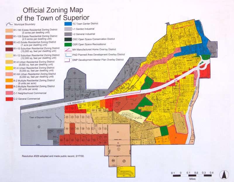
3 Zoning City governments pass bylaws that control the type and amount of development in an area. This also includes building codes etc. These rules allow the city to control the lay out of a city. Imagine a bar opening up beside your house zoning protects you from that! Zoning laws can be changed through a process that includes public hearings, but it is not easy!
4
5 Types of Urban Land Use FOR AN AVERAGE CITY: Residential = 40% Transportation = 32% Public Buildings = 10% Open Space / Rec = 7% Industrial = 6% Commercial = 5%
6 Residential Includes all the places where people live. Residential Density The number of housing units per hectare. Is dependent on the value of land. HIGH DENSITY = Large apartment buildings and condo complexes. This is because land is very costly, enough income must be generated to cover costs. MEDIUM DENSITY = townhouses, low rise apartments LOW DENSITY = single family homes and duplexes. This is because land is cheaper.

7 Old neighbourhoods sometimes lack driveways and garages and are often tightly packed. Because land is becoming more expensive, most newer developments have smaller lots so more homes can be built on less land.


8 Transportation Land Use Includes roads, highways, rail, bike paths, and facilities such as airports, stations, and parking lots. Public Buildings Land Use Schools, hospitals, gov. offices and services

9 Open Space / Recreation Land Use Includes vacant land, nature preserves, cemeteries, parks, playing fields, arenas, golf courses, and community centres.
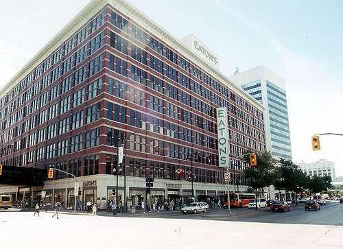
10 Industrial Land Use Includes warehouses (storage) and factories (manufacturing and processing). Can be broken down into three zones: a) CBD Industries Typically are older operations located in CBD in early part of 20 th century because: Needed to locate close to labour (no cars) Import/Export relied on river, ocean, or rail, not highways. Buildings tend to be many stories to maximize space on high value land.

11 Many of these industrial areas have become run down and depressed as industries have moved to reflect modern needs. Today, these areas are the target of urban revitalization. Old factories used as condos, art space, restaurants etc. (ex. the Exchange, Waterfront)

12 s/ /
13 2) Ribbon Industries Found along major transportation routes radiating from the city centre. 3) Industrial Parks Large areas in the suburbs with many industries. Land is cheaper and industries can have larger lots. Parks are linked to highways and other infrastructure.
14
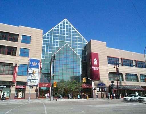
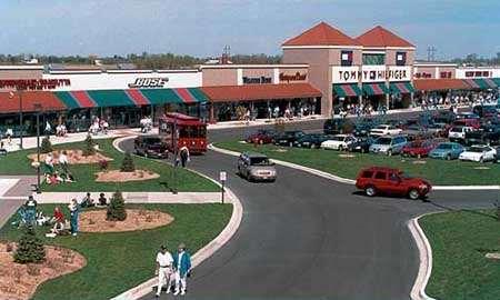
15 Commercial Land Use Includes activities linked to the buying and selling of goods (retail, banking, business) The location of commercial zones and the type of businesses found in a city has to do with threshold population. Similar to industry, most retail businesses used to locate in the CBD, today they have moved to suburban malls or regional shopping centers ( box stores ) The remaining businesses in the CBD have either closed or had to try to exploit niche markets.
16
17
18
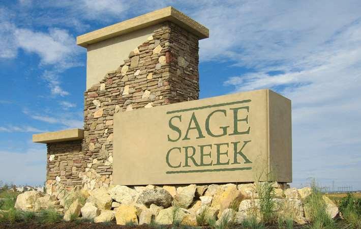
19 Urban Sprawl Refers to the outward growth of cities as people move to comfortable new suburbs. Began approximately in the 1950s with the growth in ownership of vehicles. Has led to several problems in Winnipeg: Increase in traffic, pollution, and road condition (more cars, travelling greater distances) Difficult to link up these areas with public transit. Sharing of water and sewage services with RMs? Destruction of prime agricultural land. Depressed inner city areas.
20

21
22 Downtown Revitalization The following problems have plagued Winnipeg over the last few decades, with some attempted solutions: Urban sprawl > Old and vacant buildings > Increased crime > Congested roads > Limited parking > Lack of attractions > Out of date > Not accessible >
What are Urban Landuse Zones?
 Urban Landuse Zones What are Urban Landuse Zones? Urban = Landuse = Zones = a city or densely populated area. is the function of land or what it is used for. land use varies from area to area. These are
Bylaw No , being "Official Community Plan Bylaw, 2016" Schedule "A" DRAFT
 Bylaw No. 2600-2016, being "Official Community Plan Bylaw, 2016" Schedule "A" Urban Structure + Growth Plan Urban Structure Land use and growth management are among the most powerful policy tools at the
Residential. Infill / Intensification Development Review
 Residential Infill / Intensification Development Review How Best to Manage The Compatible Integration of New Housing Within Established Residential Neighbourhoods Identification of Issues Privacy/overlook/height
14 th century the Black Death caused a huge number of deaths. Built St. Patricks Cathedral. Trinity College was built.
 Urbanisation Revision Notes Growth of Dublin over time (Marking Scheme: 12 marks 3 factors @ 4 marks each, 2 marks statement and 2 marks development.) Time Economic Factors Social Factors Administrative
Official Community Plan (OCP) LAND USE HANDBOOK
 LAND USE HANDBOOK") Official Community Plan (OCP) LAND USE HANDBOOK APRIL 2018 1 Land use designations are one of the key implementation tools for achieving the growth strategy and managing development in the city. They establish
Official Community Plan (OCP) LAND USE HANDBOOK APRIL 2018 1 Land use designations are one of the key implementation tools for achieving the growth strategy and managing development in the city. They establish
OFFICIAL COMMUNITY PLAN. PART B.1 Northeast Area Neighbourhood Plan
 OFFICIAL COMMUNITY PLAN PART B.1 Northeast Area Neighbourhood Plan 1) Context The Design Regina Plan, under the authority of The Planning and Development Act, 2007 (as amended), provides for the adoption
LAND USE. Land Cover. Current Land Use
 LAND USE Land Cover To begin the process at a more general level, land cover information was assembled to identify general patterns of developed/undeveloped areas. The data used to present this information
Demographic Change: The Changing Character of Toronto s Inner City, 1961 to 2001
 Demographic Change: The Changing Character of Toronto s Inner City, 1961 to 2001 SERIES 2 Maps based on the Canadian Census, using Census Tract level data The CURA Study Area: Bathurst St, Bloor St., Roncesvales
Planning Justification Report
 Planning Justification Report Kellogg s Lands City of London E&E McLaughlin Ltd. June 14, 2017 Zelinka Priamo Ltd. Page i TABLE OF CONTENTS Page No. 1.0 2.0 2.1 2.2 3.0 4.0 5.0 5.1 5.2 5.3 5.4 5.5 5.6
Highland Green Estates Neighbourhood Area Structure Plan
 Highland Green Estates Neighbourhood Area Structure Plan Original Outline Plan approved by Council: March 10, 1997 Outline Plan amended by Council: March 24, 1997 Converted to a Neighbourhood Area Structure
Section 2: Themes and Strategies for Healthy Apartment Neighbourhoods By Design
 Toward Healthier Apartment Neighbourhoods: A Healthy Toronto by Design Report Section 2: Themes and Strategies for Healthy Apartment Neighbourhoods By Design Themes and Strategies Theme 1: Natural Environment
Ashcroft Homes Trim Road Development Planning Rationale
 18 Antares Drive Ottawa, ON K2E 1A9 Ashcroft Homes Trim Road Development Planning Rationale Proposed Site Plan & Zoning Amendment Applications File No: D02-02-17-0129 & D07-12-17-0175 August 2018 Planning
Future Land Use Categories & Nodes December 23, Future Land Use Categories
 Future Land Use Categories & Nodes December 23, 2015 A note regarding nodes: Descriptions for nodes are located in the general recommendations handout. Node locations are set in part by the Auburn Interactive
Suburban Sprawl: Exposing Hidden Costs, Identifying Innovations. Summary
 : Exposing Hidden Costs, Identifying Innovations Summary October 2013 Suburban sprawl is spreading across Canada as cities expand outwards to accommodate the growing demand for lower cost houses. But it
Chapter 12. Key Issue Four: Why do services cluster downtown?
 Chapter 12 Key Issue Four: Why do services cluster downtown? Key Issue 4: Clustering of Services Central business district (CBD) Retail services in the CBD High land costs in the CBD Activities excluded
To achieve growth, property development, redevelopment and an improved tax base in the cities and boroughs in the Lehigh Valley.
 Most growth in property valuation is in townships. Between 1991 and 2004, the assessed valuation of the townships in the Lehigh Valley increased by more than $2.8 billion, an increase of 41%. At the same
Chapter 13: Urban Patterns Key Issues #1 & #2
 Chapter 13: Urban Patterns Key Issues #1 & #2 Key Issue #1 Why Do Services Cluster Downtown? Central Business District (CBD) CBD Downtown of a city -Less than 1% of urban land area -Focal point of transportation
7 N Main Street. 822 South 1 st Street E
 For Sale Baker Commercial Properties and Land 7 N Main Street 8203 US Highway 12 908 E Montana 912 E Montana 822 South 1 st Street E Baker, Montana 7 N Main Street 21,560 SF development lot 908 E Montana
FOR SALE CORAL GABLES DEVELOPMENT SITE ALHAMBRA CIRCLE CORAL GABLES, FL 33134
 for for a FOR SALE CORAL GABLES DEVELOPMENT SITE 367-371 ALHAMBRA CIRCLE CORAL GABLES, FL 33134 THE OFFERING Foundry Commercial is pleased to exclusively offer for sale a portfolio of two properties located
City of Oshkosh Zoning Update
 City of Oshkosh Zoning Update The Zoning Rewrite Process Commenced in June of 2013 with selection of Vandewalle and Associates as zoning rewrite consultants. Consultants, City Staff, Plan Commission, and
Brownfield Impact Assessment Report. Fall 2014
 Brownfield Impact Assessment Report Fall 2014 Municipality Types 7% 2% 5% 19% City Town Village Specialized Municipality Other 67% Population Size Represented 9% 19% 16% Under 2,500 2,501 to 10,000 Over
Housing and Homelessness. City of Vancouver September 2010
 Housing and Homelessness City of Vancouver September 2010 1 Table of Contents Overview Key Housing Issues Homelessness Rental Housing Affordable Home Ownership Key Considerations 2 OVERVIEW 3 Overview
8Land Use. The Land Use Plan consists of the following elements:
 8Land Use 1. Introduction The Land Use Plan consists of the following elements: 1. Introduction 2. Existing Conditions 3. Opportunities for Redevelopment 4. Land Use Projections 5. Future Land Use Policies
Land Use Survey Summer 2014
 Land Use Survey Summer 2014 North Ogden City, Utah Robert Scott, City Planner Travis Lund, Planning Intern Contents General Information... 1 Land Use Groups... 1 Urbanized Land Uses... 1 Residential...
Executive Summary Land Use 4-A
 Executive Summary Land Use 4-A The Land Use Element looks at how land is currently being used in Blaine, and evaluates the need for new development based on the predicted number of new residents and businesses
Chapter 9 Multiple Choice Questions
 Chapter 9 Multiple Choice Questions / Page 1 Chapter 9 Multiple Choice Questions 1. The text argues that students of real estate should study factors that influence demand at the national, regional, community
ACRE DEVELOPMENT SITE OFFERING MEMORANDUM PLAINFIELD, ILLINOIS UNIQUE INDUSTRIAL OR MIXED-USE DEVELOPMENT OPPORTUNITY
 235 CHARLES PLAINFIELD, ILLINOIS UNIQUE INDUSTRIAL OR MIXED-USE DEVELOPMENT OPPORTUNITY OFFERING MEMORANDUM ACRE DEVELOPMENT SITE GREG PACELLI Director Land Advisory Group Greg.Pacelli@colliers.com T +1
City of Sacramento Zoning Code - Zoning Descriptions Excerpt from website on April 5, 2010
 City of Sacramento Zoning Code - Zoning Descriptions Excerpt from website on April 5, 2010 RE Rural Estates Zone. This is a very low density residential zone. It is intended to be applied primarily to
OFFICE MARKET REPORT. Sandton CBD, Gauteng. June 2018
 OFFICE MARKET REPORT Sandton CBD, Gauteng BROLL INSIGHT Accessibility Sandton CBD is easily accessible via Grayston Drive off the M1 and via main arterials such as William Nicol Drive and Rivonia Road.
Chapter 13. Urban Patterns
 Chapter 13 Urban Patterns Key Issue 1: Why do services cluster downtown? 3 traditional types of services clustered in the CBD - Retailers with a high threshold, such as department stores - Retailers with
Residential Leasing Services Muscat Area Guide 2017
 Savills Oman Middle East Leasing Services Muscat Guide 2017 For those relocating to Muscat, the choice of where to live can be quite daunting and challenging. Although the city is relatively small, time
Appendix A: Guide to Zoning Categories Prince George's County, Maryland
 Appendix A: Guide to Zoning Categories Prince George's County, Maryland RESIDENTIAL ZONES 1 Updated November 2010 R-O-S: Reserved Open Space - Provides for permanent maintenance of certain areas of land
CityShaping: Draft Official Community Plan Accessory Secondary Suite with Coach House Town Hall Meeting April 15, 2014
 CityShaping: Draft Official Community Plan Accessory Secondary Suite with Coach House Town Hall Meeting April 15, 2014 Long Range Vision and Guide More Detailed Bylaws and Policies OCP Policy Areas Land
Frequently Asked Questions
 Frequently Asked Questions Cambridge West Land Use Planning Matters January 10, 2018 Q1 What is proposed for the undeveloped lands within the Cambridge West area? A. Four separate landowners each own part
Western Australia Property Report April 2015
 Western Australia Property Report National Overview This quarter, we asked Herron Todd White property experts to identify the hidden gems of Australia s residential property market locations that combine
The Park at High Crossing. vitality proximity value
 The Park at High Crossing vitality proximity value ABOUT INVESTORS ASSOCIATED, LLP Originally formed by a physicians group to invest in their own clinics, Investors Associated has been in existence for
Land Use Impacts of BRT
 Land Use Impacts of BRT Commuter Choice Workshop BRT Session Part II January 18, 2012 Victoria Perk, Senior Research Associate Cheryl Thole, Senior Research Associate National Bus Rapid Transit Institute
Annual (2013) Review of the Surrey Official Community Plan
 Review of the Surrey Official Community Plan") CORPORATE REPORT NO: R118 COUNCIL DATE: JUNE 23, 2014 REGULAR COUNCIL TO: Mayor & Council DATE: June 23, 2014 FROM: General Manager, Planning and Development FILE: 6440-01 SUBJECT: Annual (2013) Review
CORPORATE REPORT NO: R118 COUNCIL DATE: JUNE 23, 2014 REGULAR COUNCIL TO: Mayor & Council DATE: June 23, 2014 FROM: General Manager, Planning and Development FILE: 6440-01 SUBJECT: Annual (2013) Review
Residential Capacity Estimate
 Residential Capacity Estimate Montgomery County Department of Park & Planning Research & Technology Center January 2005 Current plans allow 75,000 more housing units. by Matthew Greene, Research Planner
UrbanFootprint Place Types. Urban Mixed Use. Urban Residential. Urban Commercial. Residential 1% SF Large Lot 0%
 Urban Mixed Use Residential 18% SF Large Lot 0% Employment 16% SF Small Lot 0% Mixed Use 45% Townhome 0% Open Space/Civic 21% MultiFamily 100% Intersections per mi 2 200 Office 80% Average Floors 23 Retail
UNDERSTANDING THE TAX BASE CONSEQUENCES OF LOCAL ECONOMIC DEVELOPMENT PROGRAMS
 UNDERSTANDING THE TAX BASE CONSEQUENCES OF LOCAL ECONOMIC DEVELOPMENT PROGRAMS Richard K. Gsottschneider, CRE President RKG Associates, Inc. 277 Mast Rd. Durham, NH 03824 603-868-5513 It is generally accepted
WYNYARD CENTRAL HOUSING POLICY
 WYNYARD CENTRAL HOUSING POLICY 1 Policy objectives 1.1 To clarify the approach that Waterfront Auckland (WA) will take to delivering a thriving residential community. 2 Scope 2.1 Covers the approach to
Salem HNA and EOA Advisory Committee Meeting #6
 Salem HNA and EOA Advisory Committee Meeting #6 Residential Land Policies Employment Land Policies Policy Discussions with the Committee Outcome of today s meeting Direction from this Committee on proposed
CHAPTER 50 LAND USE ZONES ARTICLE 50 BASIC PROVISIONS
 CHAPTER 50 LAND USE ZONES ARTICLE 50 BASIC PROVISIONS 50.010 - PURPOSE The purposes of this chapter are to establish land use zones required to implement the goals and policies of the Klamath County Comprehensive
Poughkeepsie City Center Revitalization Plan
 Purpose and Need Purpose Increase job and educational opportunities for all residents Maximize fiscal productivity of downtown land uses Diversify retail mix Eliminate surface and building vacancies Create
SE corner of Locust Street and Loop 288, Denton, Texas
 1400 DALLAS DRIVE, DENTON, TX. 76205 Telephone (940) 484-9000; Fax (940) 380-9000 SE corner of Locust Street and Loop 288, Denton, Texas Map of location What type of retail is best suited for this location?
Plan Santa Paula Workshop III: Evaluating the Proposed Housing Plans. Summary of Participant Comments
 Plan Santa Paula Workshop III: Evaluating the Proposed Housing Plans Summary of Participant Comments Following a presentation and panel discussion regarding potential impacts to water, fiscal resources,
Mohave County General Plan
 63 64 65 66 67 68 69 70 71 The Land Use Diagram is not the County's zoning map. 13 It is a guide to future land use patterns. Zoning and area plan designations may be more restrictive than the land use
Outline of Land Use Bylaw, 1P2007 Changes
 Outline of Land Use Bylaw, 1P2007 Changes Changes to single and multi-family builders, renovators, land developers and trades The City s new Land Use Bylaw, 1P2007 has been approved by Council. The new
City of Regina Underutilized Land Study External Stakeholder Report
 City of Regina Underutilized Land Study External Stakeholder Report March 2018 Developed by: Introduction The City of Regina has undertaken an Underutilized Land Study. This study investigated potential
Lee Blvd & Waverley St Winnipeg, Manitoba
 Lee Blvd & Waverley St Winnipeg, Manitoba Executive Summary A city that mixes business with pleasure, creativity with capability, and opportunity with productivity, Winnipeg has been known as Canada s
Metro Vancouver's 2011 Generalized Land Use by Municipality (Net Land Area - excluding dedicated road right-of-way and water bodies)
") METRO VANCOUVER Land Percent Share Land Use Category Area (ha) of METRO Total Agriculture 48,822 17.1% Airport/Airstrip 1,577 0.6% Cemetery 292 0.1% Commercial 2,980 1.0% Harvesting and Research 8,630
METRO VANCOUVER Land Percent Share Land Use Category Area (ha) of METRO Total Agriculture 48,822 17.1% Airport/Airstrip 1,577 0.6% Cemetery 292 0.1% Commercial 2,980 1.0% Harvesting and Research 8,630
Neighborhood Parks and Residential Property Values in Greenville, South Carolina. Molly Espey Kwame Owusu-Edusei
 Neighborhood Parks and Residential Property Values in Greenville, South Carolina Molly Espey Kwame Owusu-Edusei Department of Agricultural and Applied Economics Clemson University January 2001 This research
DRAFT FOR DISCUSSION PURPOSES ONLY. Port Credit Local Area Plan Built Form Guidelines and Standards DRAFT For Discussion Purposes
 Port Credit Local Area Plan Built Form Guidelines and Standards DRAFT For Discussion Purposes 1 Local Area Plan - Project Alignment Overview Directions Report, October 2008 (General Summary Of Selected
2. LAND USE DESIGNATIONS AND PRINCIPLES FOR DEVELOPMENT
 2. LAND USE DESIGNATIONS AND PRINCIPLES FOR DEVELOPMENT General areas have been designated for specific types of land use on the Future Land Use Map and are described in this section. In order to satisfy
INFILL DEVELOPMENT. Elective Course January 14, 2017 Derek Pomreinke Tammy Henry Nazim Virani
 INFILL DEVELOPMENT Elective Course January 14, 2017 Derek Pomreinke Tammy Henry Nazim Virani Agenda 9:05 What is infill? 9:20 How is it regulated? 9:45 How do developers view infill? Break 10:30 Applications
4.0. Residential. 4.1 Context
 4. 0Residential 4.1 Context In 1986, around the time of Burnaby s last Official Community Plan, the City had a population of 145,000 living in 58,300 residential units. By 1996, there were 179,000 people
Downtown Development Focus Area: I. Existing Conditions
 Downtown Development Focus Area: I. Existing Conditions The Downtown Development Focus Area is situated along Route 1, south of the train tracks, except for the existing Unilever property. It extends west
Demographics. Delray Beach is one of 38 municipalities in Palm Beach County, occupying approximately 16 square miles.
 Demographics Palm Beach County 2010 Population 60,500 White 66% Black 28 % Hispanic 10% Per Capita Income - $36,600 Median HH Income - $49,750 Median Value of Owner Occ. Housing - $260K Home Ownership
NIS WINNIPEG INVESTMENT LISTINGS UPDATE February 2016
 NIS WINNIPEG INVESTMENT LISTINGS UPDATE FEATURED LISTINGS New Listing New Listing For Sale 1151-1155 Sherwin Road 59,900 sf multi-tenant industrial property located in St. James Industrial Park with close
Village of Queen Charlotte OCP and Bylaw Review Open House April 29, 2017 Highlights, Policy Directions, and Choices
 Village of Queen Charlotte OCP and Bylaw Review Open House April 29, 2017 Highlights, Policy Directions, and Choices Purpose The purposes of the open house were: 1) to receive community input on topics
CITY OF TORONTO ZONING BY-LAW
 CITY OF TORONTO ZONING BY-LAW BY-LAW NO. 569-2013 ENACTED BY CITY COUNCIL MAY 9, 2013 OFFICE CONSOLIDATION Chapters 1-800 of By-law No. 569-2013 - as amended Updated August 20, 2014 If a regulation in
North Star Building Offering
 North Star Building Offering Great Add-Value Opportunity OVERVIEW The Offering Great Location * Easy Freeway Access * Warehouse * Small & Large Offices * Dedicated Parking * HSI * Fiber Optics Parker Property
Financing Municipal Services for Sustainable Development Getting the Prices Right
 Financing Municipal Services for Sustainable Development Getting the Prices Right Presentation to the Urban Development Conference University of Alberta April 10, 2014 Enid Slack Institute on Municipal
RBC-Pembina Home Location Study. Understanding where Greater Toronto Area residents prefer to live
 RBC-Pembina Home Location Study Understanding where Greater Toronto Area residents prefer to live RBC-Pembina Home Location Study: Understanding where Greater Toronto Area residents prefer to live July
City Council Briefing Clear Creek Holdings, LLC. April 16, 2019 Robert J. Tajan, Director Planning and Community Development
 City Council Briefing April 16, 2019 Robert J. Tajan, Director Planning and Community Development 1 AICUZ Background Air Installation Compatible Use Zones Established in response to the Noise Control Act
Dense housing and urban sustainable development
 The Sustainable City VI 443 Dense housing and urban sustainable development B. Su School of Architecture, Unitec Institute of Technology, New Zealand Abstract There are close relationships between urban
The Characteristics of Land Readjustment Systems in Japan, Thailand, and Mongolia and an Evaluation of the Applicability to Developing Countries
 ISCP2014 Hanoi, Vietnam Proceedings of International Symposium on City Planning 2014 The Characteristics of Land Readjustment Systems in Japan, Thailand, and Mongolia and an Evaluation of the Applicability
FEASIBILITY REPORT. 1486, 1490 and 1494 Clementine. Prepared by: Lloyd Phillips & Associates Ltd. For: Ottawa Salus
 DRAFT FEASIBILITY REPORT 1486, 1490 and 1494 Clementine Prepared by: Lloyd Phillips & Associates Ltd. For: Ottawa Salus LPA File No. 1008 Lloyd Phillips & Associates June 9, 2010 Feasibility Report Page
Promoting informed debate around infill housing in Australian cities
 Promoting informed debate around infill housing in Australian cities 1 SGS has long been interested in promoting infill housing in Australian cities. This support reflects the recognised net benefits infill
ATTACHMENT NO Growth and Staging of Development Report
 ATTACHMENT NO. 1 2016 Growth and Staging of Development Report This page intentionally left blank. Table of Contents Introduction... 2 Section 1: Provincial Policy Statement (2014) and Provincial Growth
Welcome. City of Abbotsford Zoning Bylaw Update. June 25 th obtain your feedback on key changes to the Bylaw.
 Welcome City of Abbotsford Zoning Bylaw Update June 25 th 2014 Thank you for attending this open house. The City of Abbotsford is updating its Zoning Bylaw and wants your input. The purpose of this open
THE EFFECT OF PROXIMITY TO PUBLIC TRANSIT ON PROPERTY VALUES
 THE EFFECT OF PROXIMITY TO PUBLIC TRANSIT ON PROPERTY VALUES Public transit networks are essential to the functioning of a city. When purchasing a property, some buyers will try to get as close as possible
Miami-Dade County Office Market Report 1Q Real Capital Partners Real Estate Services
 -Dade County Office Report 1Q 216 Real Capital Partners Real Estate Services 1Q 216 -Dade County Office Report Overview -Dade County s Vacancy Increases to 1.4% Net Negative (11,64) SF in the Quarter The
Planned Densification. Dan Slone McGuireWoods LLP 901 East Cary Street Richmond, Virginia
 Planned Densification Dan Slone McGuireWoods LLP 901 East Cary Street Richmond, Virginia 23219 804.775.1041 dslone@mcguirewoods.com Suburban Retrofit Suburban Upgrade Planned Retrofit Blight Replacement
HOUSING AFFORDABILITY
 HOUSING AFFORDABILITY (RENTAL) 2016 A study for the Perth metropolitan area Research and analysis conducted by: In association with industry experts: And supported by: Contents 1. Introduction...3 2. Executive
Rural Living (RL) Rural Living
 Rural Living") Place Types Rural Living (RL) Rural Living Rural living areas are characterized by very large lots, abundant open space, pastoral views, and a highdegree of separation between buildings. The lots are typically
Place Types Rural Living (RL) Rural Living Rural living areas are characterized by very large lots, abundant open space, pastoral views, and a highdegree of separation between buildings. The lots are typically
LANGSTAFF ROAD REGIONAL ROAD 7 INTERCHANGE WAY HIGHWAY 407 JANE STREET CITY OF TORONTO. Development Planning Department
 LANGSTAFF ROAD HIGHWAY 400 WESTON ROAD REGIONAL ROAD 7 HIGHWAY 407 JANE STREET Context Location Map STEELES AVENUE WEST Document Path: N:\GIS_Archive\s\OP\OP.18.014\OP.18.014_PublicHearing_ContextLocationMap.mxd
180 acres of Development Land in CentrePort for Sale
 PERIMETER HIGHWAY Future Lands New Opportunity CN RAIL LINE Chief Peguis Extension ROUTE 90 General Logistics Park Recreation/ Open Space Brookside Business Park PERIMETER HIGHWAY Municipal Boundary Manufacturing
LAND FOR SALE - Planned Area Development/Commercial Z Acres (1,205,740 Sq. Ft.) $10,851,667 / $9.00 Sq. Ft Acres
 $10,851,667 / $9.00 Sq. Ft Acres") LAND FOR SALE - Planned Area Development/Commercial Z 27.68 Acres (1,205,740 Sq. Ft.) $10,851,667 / $9.00 Sq. Ft. 1877 East Florence Boulevard, Casa Grande, Arizona 27.68 Acres LOCATION: The site wraps
LAND FOR SALE - Planned Area Development/Commercial Z 27.68 Acres (1,205,740 Sq. Ft.) $10,851,667 / $9.00 Sq. Ft. 1877 East Florence Boulevard, Casa Grande, Arizona 27.68 Acres LOCATION: The site wraps
Northern Territory Property Report January 2014
 Northern Territory Property Report National Overview This quarter we look around the nation to identify affordable properties with the potential to deliver healthy long term gains suitable for first home
Planning Justification Report
 Planning Justification Report 103 and 105 Toronto Street Town of Markdale, Municipality of Grey Highlands Maverick Developments November 5, 2016 Zelinka Priamo Ltd. Page i TABLE OF CONTENTS Page No. 1.0
Corporate Report. 2. That the Interim Control By-law prohibit within the Low Density Residential Suburban Neighbourhood (R1) zone, the following:
 zone, the following:") Corporate Report Report from Planning and Building Services, Planning Services Date of Report: November 23,2016 Date of Meeting: December 5, 2016 Report Number: PBS-330-2016 File: 60.35.2.1 Subject: Interim
Corporate Report Report from Planning and Building Services, Planning Services Date of Report: November 23,2016 Date of Meeting: December 5, 2016 Report Number: PBS-330-2016 File: 60.35.2.1 Subject: Interim
Technology Park Planned Unit Development Technology Park PUD-IP
 Technology Park Planned Unit Development Technology Park PUD-IP Rob Anderson Community Development Director Planned Unit Development Background 2 Planned Unit Development (PUD) means a mixed use redevelopment
GENERAL PLAN UPDATE. Online Workshop 1 Results. May 26, 2016
 GENERAL PLAN UPDATE Online Workshop 1 Results May 26, 2016 ONLINE WORKSHOP OVERVIEW ONLINE WORKSHOP Online tool live from April 15 - May 8 Showed details related to 11 potential transform areas Comment
DEVELOPMENT INCENTIVES. 10 Year Tax Exemption Waiver of DCCs for Non-Profit Housing Units Reduced DCCs ($299 per unit) $10,000 Per Residential Unit
 $10,000 Per Residential Unit") DEVELOPMENT INCENTIVES 10 Year Tax Exemption Waiver of DCCs for Non-Profit Housing Units Reduced DCCs ($299 per unit) $10,000 Per Residential Unit PRINCE GEORGE DEVELOPMENT INCENTIVES PRINCE GEORGE ECONOMIC
DEVELOPMENT INCENTIVES 10 Year Tax Exemption Waiver of DCCs for Non-Profit Housing Units Reduced DCCs ($299 per unit) $10,000 Per Residential Unit PRINCE GEORGE DEVELOPMENT INCENTIVES PRINCE GEORGE ECONOMIC
Planning and Development Committee. Planning and Building Department. Recommendation: Purpose: Page 1 of Report PB-39-17
 Page 1 of Report PB-39-17 SUBJECT: Statutory Public Meeting and Recommendation Report for a Proposed Zoning By-law Amendment for 1333 Lakeshore Road and adjacent hydro corridor lands TO: FROM: Planning
SUBDIVISION AND DEVELOPMENT APPEAL BOARD
 SUBDIVISION AND DEVELOPMENT APPEAL BOARD DECISION Hearing held at: Calgary, Alberta Date of hearing: January 19, 2012 Members present: Chairman, Rick Grol Meg Bures Terry Smith Andrew Wallace Basis of
JASPER PLACE NEIGHBOURHOOD HOUSING ASSESSMENT NOVEMBER West Jasper Place. Glenwood. Britannia Youngstown. Canora
 JASPER PLACE NEIGHBOURHOOD HOUSING ASSESSMENT NOVEMBER 2013 West Jasper Place Glenwood Britannia Youngstown Canora TABLE OF CONTENTS A: INTRODUCTION................................... 01 B: PHOTOGRAPHIC
APPENDIX C CHARACTERISTICS OF THE ENERGIZE PHOENIX CORRIDOR
 APPENDIX C CHARACTERISTICS OF THE ENERGIZE PHOENIX CORRIDOR BACKGROUND ON RESIDENTIAL AND COMMERCIAL BUILDINGS IN THE EP CORRIDOR The 10-mile EP corridor (Figure G1) is a highly diverse, mixed-use L-shaped
MONTGOMERY COUNTY RENTAL HOUSING STUDY. NEIGHBORHOOD ASSESSMENT June 2016
 MONTGOMERY COUNTY RENTAL HOUSING STUDY NEIGHBORHOOD ASSESSMENT June 2016 AGENDA Model Neighborhood Presentation Neighborhood Discussion Timeline Discussion Next Steps 2 WORK COMPLETED Socioeconomic Analysis
3. FISCAL IMPACT ANALYSIS FISCAL IMPACT ANALYSIS 29
 3. FISCAL IMPACT ANALYSIS FISCAL IMPACT ANALYSIS 29 The purpose of fiscal impact analysis is to estimate the impact of a development or a land use change on the budgets of governmental units serving the
Chapter 13: Urban Patterns Key Issues #3 & #4
 Chapter 13: Urban Patterns Key Issues #3 & #4 Key Issue #3 Why Do Inner Cities Face Distinctive Challenges? Physical Problems of Inner City Housing Poor Condition of Housing - Built before 1940 Middle
PLANNING AND REGULATING HOUSING OPTIONS FOR CHANGING DEMOGRAPHICS
 PLANNING AND REGULATING HOUSING OPTIONS FOR CHANGING DEMOGRAPHICS New Partners for Smart Growth Conference February 2017 HOUSING MARKETS Significant increase in rental housing Offset robust single-family
Consultation on Increasing Housing Supply in Ontario: A guide for Ontario s co-op housing sector
 Consultation on Increasing Housing Supply in Ontario: A guide for Ontario s co-op housing sector The Government of Ontario is currently holding a consultation: Increasing Housing Supply in Ontario. CHF
Finding the Balance:
 TOWN OF BETHLEHEM Finding the Balance: The Importance of Fiscal Balance Considerations in Community Planning July 11, 2008 1 PRESENTATION OVERVIEW 1. Introductions 2. Fiscal Impact Analysis Overview 3.
Property Location: 2970 Bank Road
 When? Where? Why? Tuesday, May 29, 2018, 7:00 pm Council Chambers, City Hall, 7 Victoria Street West Kamloops City Council will hold a Public Hearing to consider the following proposed amendments to City
GENEVA APARTMENTS Aurora Ave N Seattle, WA A MULTI-FAMILY DEVELOPMENT OPPORTUNITY
 GENEVA APARTMENTS A MULTI-FAMILY DEVELOPMENT OPPORTUNITY PROPERTY HIGHLIGHTS QUEEN ANNE LAKE UNION URBAN LOCATION LISTED PRICE: $2,500,000 36 UNITS 16 PARKING SPACES C1-65 ZONING 9,700 SF LOT SIZE CLOSE
Affording Coralville: A Conversation about Our Housing Needs Coralville Public Library
 Affording Coralville: A Conversation about Our Housing Needs Coralville Public Library OBJECTIVE Community Discussion September 16, 2015 Affordable housing is an issue that tends to escape municipal boundaries.
Chapter 2: Existing Land Use
 Chapter 2: Existing Land Use Existing Land Use An inventory of existing land use describes existing patterns of development. The inventory provides useful information to calculate the ultimate population