URBAN INFILL HOUSING OPTIONS
|
|
|
- Katrina Murphy
- 5 years ago
- Views:
Transcription


1 URBAN INFILL HOUSING OPTIONS
2 1. Table of Contents Introduction (2-3) Downtown Specific Plan Goals (4-5) What is Higher Density Housing? (6) What is Floor Area Ratio (FAR) and Why is FAR Important to Urban Infill? (7) Transit-Oriented Development (8-11) Mixed-Use/Multi-Story Housing (12-15) Historic/Adaptive Reuse Housing (16-19) 1
3 2. Introduction Downtown Sacramento is a vibrant community living in the area bound by the Sacramento River to the West, the American River to the North, Highway 80 to the East, and Highway 50 to the South. The housing supply in Downtown has not grown significantly over the past decade, creating a deficit in supply however the demand for more housing remains high and continues to grow. To alleviate this problem, Mayor Kevin Johnson has introduced a new Downtown Housing Initiative to develop 10,000 places to live in Downtown Sacramento over the next ten years. The Downtown Specific Plan implements this initiative by looking at growth opportunities over next twenty years. Infill development, redevelopment, reuse, and growth in existing urbanized areas enhances community character, optimizes City investments in infrastructure and community facilities, supports increased transit use, promotes pedestrian- and bicycle friendly neighborhoods, increases housing diversity, ensures integrity of historic districts, and enhances retail viability. This plan is the City of Sacramento s strategy to attract more residential infill development throughout Downtown Sacramento while enhancing the quality of life city-wide. This document explains the type of housing development that will help Sacramento meet the desired number of housing units and meet the goals of the Downtown Specific Plan. The types of housing developments include: Transit-Oriented Development Mixed-Use/Multi-Story Housing Historic/Adaptive Reuse Housing Some of the examples shown in this document may fit into more than one category. The City will highlight and evaluate opportunity sites with high potential for development. The City will be working with development experts, community based interest groups, and the community at large to achieve the best plan possible through engagement tools such as stakeholder meetings, community workshops, and online engagement. 2 3

4 3. Goals of the Downtown Specific Plan Create a Specific Plan that paves the way for at least 10,000 places to live in the next 10 years Develop a varied housing stock that reflects the current diversity of Sacramento Maintain the quality of life central city residents experience and further neighborhood livability by including supporting amenities along with housing Remove housing development barriers by streamlining the growth and environmental review process Maintain the quality of life central city residents experience and further neighborhood livability by including supporting amenities along with housing 4 5


5 What is higher density housing? To substantially increase the number of housing units in the Downtown area, higher density housing will need to be built. Higher density does not exclusively refer to high-rise buildings. The definition of density depends on the context in which it is used. For Downtown Sacramento, higher density simply means new residential development at a density that is higher than single family home or attached townhomes. The image on below depicts different types of housing densities. For Downtown Sacramento, higher density can be anything between to 150+ dwelling units per acre. What is Floor Area Ratio (FAR) and Why is FAR Important to Urban Infill? What is a floor area ratio or FAR? The best way to define an FAR is to give an example. An FAR of 1.0 means that the developer is allowed to build the equivalent of a one-story building over the entire lot, or a 2-story over half the lot. An FAR of 2.0 means the developer is allowed to build the equivalent of a two-story building over her entire lot, or a 4-story over half the lot. While the FAR examples given above that exceed 1.0 may seem very dense, keep in mind that in most cases an FAR of 1.0 would not allow the developer to build one story over the entire lot, as other local development code regulations would also require space for landscaping/ open space, parking, setbacks, etc. A truly walkable community that creates healthy transit require FARs to be at least 1.5 to 3.0. Most of the cities that we all love to walk in have FARs that are probably well over 3.0. Low FARs create unwalkable large spaces that are more car-scaled than people-scaled. 6 7


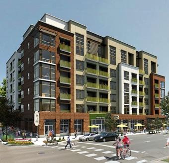
6 The Cathedral Building Corner of 12th & K Streets Transit-Oriented Development: Transit-oriented development, or TOD, is a type of housing development that is located within a halfmile of quality public transportation. Most often this embraces a mixture of housing with office, retail and/or other amenities integrated into a walkable neighborhood. The Cathedral Building Density: 79 units/acre Floor Area Ratio: 3.0 Pensione K Corner of 17th & K Streets Pensione K Density: 186 units/acre Floor Area Ratio: 1.5 Township 9/Cannery Place Density: units/acre Floor Area Ratio:
")

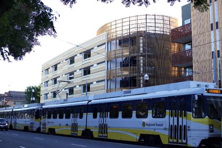
7 Transit-Oriented Development Benefits: Reduces vehicle miles traveled (VMT) Less VMT means: Improved public health Reduced dependency on cars Reduced air pollution and greenhouse gas (GHG) emissions Easier transit use, pedestrian activity and biking Minimizes length or need for vehicle trips Encourages a pedestrian-friendly community Township 9/Cannery Place Richards Blvd & N 7th Streets 10 11


8 Mixed-Use/Multi-Story Housing: 800 J Lofts Corner of 8th and J Streets Mixed-Use/Multi-Story housing blends residential, commercial, cultural, institutional, or industrial uses into multi-story projects. 800 J Lofts Density: 189 units/acre Floor Area Ratio: L Lofts Density: 99 units/acre Floor Area Ratio: Powerhouse Density: 114 units/acre Floor Area Ratio: L Lofts 12 Corner of 18th & L Streets 13


9 Mixed-Use/Multi-Story Housing Benefits: Supports local retail and entertainment C ultivates a safe, vibrant neighborhood bustling with pedestrians Leads to more cohesive communities with a strong identity Improves access to amenities C reates a sense of place through ground floor retail and commercial uses 16 Powerhouse Corner of 16th & P Streets 14 15


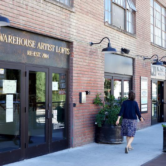
10 Historic/Adaptive Reuse Housing: Lofts at Globe Mills Corner of 11th & C Streets Historic/Adaptive Reuse Housing reuses an old site or building for a purpose other than which it was built or designed for. Sacramento has actively readapted many historic buildings to better fit the needs of Downtown s residents. The Downtown Specific Plan will evaluate key opportunity sites that have 45+ year old properties for historic/adaptive reuse. Lofts at Globe Mills Density: 121 units/acre Floor Area Ratio: 0.4 MAY Building Density: 93 units/acre Floor Area Ratio: 2.89 MAY Building 16 Corner of 10th and K Streets Warehouse Artist Lofts Density: units/acre Floor Area Ratio:


11 Historic/Adaptive Reuse Housing Benefits: Effective reuse of land Reduces urban sprawl Maintains original building character Respects local and national landmarks Conserves material and cultural resources Adds to neighborhood character Warehouse Artist Lofts Corner of 11th & R Streets 18 19
12
Using Performance Measures to Improve Parking Policies & Livability
 Using Performance Measures to Improve Parking Policies & Livability UTCM Conference Performance Measures for Livable Communities Valerie Knepper Metropolitan Transportation Commission SF Bay Area 7 Million
ASSEMBLY BILL No. 904
 AMENDED IN SENATE JULY, 0 AMENDED IN SENATE JUNE, 0 AMENDED IN SENATE JUNE, 0 AMENDED IN ASSEMBLY JANUARY, 0 AMENDED IN ASSEMBLY MAY 0, 0 AMENDED IN ASSEMBLY APRIL, 0 AMENDED IN ASSEMBLY MARCH, 0 california
Chapter URBAN VILLAGE ZONING DISTRICTS
 Chapter 20.16 Sections: 20.16.010 Purpose of the Urban Village Zoning Districts 20.16.020 Land Use Regulations for the Urban Village Zoning Districts 20.16.030 Development Standards & Guidelines for the
Poughkeepsie City Center Revitalization Plan
 Purpose and Need Purpose Increase job and educational opportunities for all residents Maximize fiscal productivity of downtown land uses Diversify retail mix Eliminate surface and building vacancies Create
Twin Cities Region Equitable Development Principles & Scorecard
 Twin Cities Region Equitable Development Principles & Scorecard a tool for communities and planners June 2014 Created by Community Engagement Steering Committee Equitable Development working group: Asian
MEMORANDUM. I1 District Industrial Living Overlay District 110,703 square feet / 2.54 acres
 Department of Community Planning & Economic Development 250 South 4th Street, Room 300 Minneapolis, MN 55415-1385 MEMORANDUM To: City Planning Commission, Committee of the Whole Prepared By: Peter Crandall,
COMPLETE NEIGHBORHOODS AND HOUSING. Community Summit 02 February, 2012
 Lake Oswego Comprehensive Plan COMPLETE NEIGHBORHOODS AND HOUSING Community Summit 02 February, 2012 vision statement We have a wide variety of neighborhoods with high quality, attractive and compatible
From Policy to Reality
 From Policy to Reality Updated ^ Model Ordinances for Sustainable Development 2000 Environmental Quality Board 2008 Minnesota Pollution Control Agency Funded by a Minnesota Pollution Control Agency Sustainable
Salem HNA and EOA Advisory Committee Meeting #6
 Salem HNA and EOA Advisory Committee Meeting #6 Residential Land Policies Employment Land Policies Policy Discussions with the Committee Outcome of today s meeting Direction from this Committee on proposed
DOWNTOWN SPECIFIC PLAN
 DOWNTOWN SPECIFIC PLAN AGENDA OVERVIEW Goals & Objectives Opportunity Sites Market Analysis Next Steps GOALS & OBJECTIVES Create a Specific Plan that paves the way for at least 10,000 places to live in
2.0 LAND USE FRAMEWORK
 Land Use Framework 2.0 LAND USE FRAMEWORK FOLSOM BOULEVARD 2.1 LAND USE OVERVIEW The proposed land uses for Easton Place offer local and regional employment, shopping, and entertainment, highlighting the
CITY OF PORTSMOUTH. CITY COUNCIL POLICY No HOUSING POLICY
 CITY OF PORTSMOUTH CITY COUNCIL POLICY No. 2016-03 HOUSING POLICY WHEREAS, the goals of the City of Portsmouth, as expressed in its 2025 Master Plan, include encouraging walkable mixed-use development,
TOD: Types of Capital Investment
 TOD Finance and M&E TOD: Types of Capital Investment When considering financing strategies for TOD corridor development, what needs to be financed? Transit Infrastructure Street Infrastructure & Public
DRAFT Plan Incentives. Part A: Basic Discount
 DRAFT 2030 Plan Incentives July 26, 2006 Part A: Basic Discount In order for a development to be eligible for any 2030 Land Resource Management Plan Discounts it must be located in the Urban Corridor and
CPC CA 3 SUMMARY
 CPC-2009-3955-CA 2 CONTENTS Summary Staff Report Conclusion 3 4 7 Appendix A: Draft Ordinance A-1 Attachments: 1. Land Use Findings 2. Environmental Clearance 1-1 2-1 CPC-2009-3955-CA 3 SUMMARY Since its
Puyallup Downtown Planned Action & Code Changes. January 10, 2017
 Puyallup Downtown Planned Action & Code Changes January 10, 2017 Purpose & Location Purpose Promote economic development and downtown revitalization Tools: Municipal Code amendments Change development
FOR SALE 140 N. BRENTWOOD CLAYTON, MO FOR SALE DOWNTOWN CLAYTON OPPORTUNITY LAND AVAILABLE FOR REDEVELOPMENT
 FOR SALE 140 N. BRENTWOOD CLAYTON, MO FOR SALE DOWNTOWN CLAYTON OPPORTUNITY LAND AVAILABLE FOR REDEVELOPMENT TABLE OF CONTENTS Section1 Section 2 Section 3 Section 4 Offering Summary Development Opportunity
MERIDEN TOD A NEW TRANSIT-ORIENTED DEVELOPMENT DISTRICT ZONING REGULATION FOR MERIDEN. Greater Meriden Chamber & Connecticut Bar Association
 A NEW TRANSIT-ORIENTED DEVELOPMENT DISTRICT ZONING REGULATION FOR MERIDEN PRESENTATION TO Greater Meriden Chamber & Connecticut Bar Association 25 September 2013 Dominick J. Caruso, AICP Director of Planning
APPENDIX D: DEFINITIONS
 D APPENDIX D: DEFINITIONS Terms used throughout the 2040 Comprehensive Plan should be interpreted using the definitions provided in this appendix. For interpretation of any term not defined, defer to the
Bridgeland-Riverside Area Redevelopment Plan (ARP)
") Bridgeland-Riverside Area Redevelopment Plan (ARP) The current Bridgeland-Riverside Area Redevelopment Plan (ARP) was approved in 1980. Since then, a lot of changes have taken place in the city and the
Bridgeland-Riverside Area Redevelopment Plan (ARP) The current Bridgeland-Riverside Area Redevelopment Plan (ARP) was approved in 1980. Since then, a lot of changes have taken place in the city and the
PLANNING AND IMPLEMENTING TOD: KEY FACTORS FOR SUCCESS. Sujata Srivastava Knowledge Corridor TOD Workshop June 5, 2013
 PLANNING AND IMPLEMENTING TOD: KEY FACTORS FOR SUCCESS Sujata Srivastava Knowledge Corridor TOD Workshop June 5, 2013 6-year old partnership dedicated to improving practice through technical assistance,
City of Spokane Infill Development. June 30, 2016
 City of Spokane Infill Development June 30, 2016 Today s Agenda Introductions Background and Adopted Policy Infill Forms: Facilitated Group Discussion Small-Group Discussions Groups Report Out Next Steps
NC 54/I-40 Corridor Master Plan Draft Land Use Blueprint
 NC 54/I-40 Corridor Master Plan Draft Land Use Blueprint Introduction The following presents a summary of Community Elements as recommended for consideration in the NC 54 study corridor. Images are provided
Summary of Findings. Community Conversation held November 5, 2018
 Summary of Findings Housing and the Future of Lebanon: What types of homes do we need in Lebanon to have a thriving community for all who live or work here? Community Conversation held November 5, 2018
REZONING GUIDE. Zone Map Amendment (Rezoning) - Application. Rezoning Application Page 1 of 3. Return completed form to
 - Application. Rezoning Application Page 1 of 3. Return completed form to") Zone Map Amendment (Rezoning) - Application COMMUNITY PLANNING & DEVELOPMENT REZONING GUIDE Rezoning Application Page 1 of 3 PROPERTY OWNER INFORMATION* CHECK IF POINT OF CONTACT FOR APPLICATION Property
Zone Map Amendment (Rezoning) - Application COMMUNITY PLANNING & DEVELOPMENT REZONING GUIDE Rezoning Application Page 1 of 3 PROPERTY OWNER INFORMATION* CHECK IF POINT OF CONTACT FOR APPLICATION Property
Ann Arbor Downtown Zoning Evaluation
 Ann Arbor Downtown Zoning Evaluation Options Workbook ENP & Associates in cooperation with the City of Ann Arbor September, 2013 Photo Courtesy of Andrew Horne, February 9, 2013 Introduction Thank you
Salinas Master Plan. Project Description
 Salinas Master Plan Project Description Table of ontents Report.0 Project Overview.0 Land Use 3.0 Transportation & Infrastructure.0 ommunity enefits 5.0 Sustainable Development.0 Development Schedule
Using Analysis to Improve the Environment for Transit
 Using Analysis to Improve the Environment for Transit POWERFUL ANALYTIC TOOLS Envision Tomorrow/ process Step 1: Scenario development starts by creating a library of building types that are financially
Submission 1 - April 21, 2015
 383 Herring Cove Road - MPS Amendment Rationale and Changes Submission 1 - April 21, 2015 7 storeys/70 high, with a 24 streetwall 82 residential units 5,790 sqf of commercial space 21,405 sqf of amenity
SERVICE & IMPROVEMENT PLAN AND ASSESSMENT PLAN:
 DOWNTOWN MIDLAND MANAGEMENT DISTRICT SERVICE & IMPROVEMENT PLAN AND ASSESSMENT PLAN: 2010-2019 August 25, 2009 Table of Contents 1. Introduction...1 2. Background: The First Five Years...2 3. Service &
Bylaw No , being "Official Community Plan Bylaw, 2016" Schedule "A" DRAFT
 Bylaw No. 2600-2016, being "Official Community Plan Bylaw, 2016" Schedule "A" Urban Structure + Growth Plan Urban Structure Land use and growth management are among the most powerful policy tools at the
Glendale Housing Development Project Plan
 Glendale Housing Development Project Plan Draft for Public Review May 29, 2015 Table of Contents I. Introduction... 1 II. Description of Project... 1 A. Boundary of Housing Development Project... 1 B.
February 1, City of Verona Planning & Development 111 Lincoln Street Verona, WI 53593
 February 1, 2018 City of Verona Planning & Development 111 Lincoln Street Verona, WI 53593 Re: PUD/GDP Plan Submittal 102 Lincoln Street Verona, WI 53593 KBA Project # 1646 This PUD/GDP submittal is for
Chapter 5: Testing the Vision. Where is residential growth most likely to occur in the District? Chapter 5: Testing the Vision
 Chapter 5: Testing the Vision The East Anchorage Vision, and the subsequent strategies and actions set forth by the Plan are not merely conceptual. They are based on critical analyses that considered how
PLANNING COMMISSION STAFF REPORT
 PLANNING COMMISSION STAFF REPORT REZONING CASE: RZ-16-001 REPORT DATE: March 8, 2016 CASE NAME: Trailbreak Partners Rezoning PLANNING COMMISSION DATE: March 16, 2016 ADDRESSES OF REZONING PROPOSAL: 5501
Appendix D - Manheim Township Zoning Ordinance
 T-3 Zone: Weatherstone West Vincent Township - Chester County, PA Total Acres: 300.0 Residential: 273 Single-Family Units Neighborhood Core: 240,000 SF Open Space: 195.0 Acres Residential Lot Area: 7,200-11,700
You really can create great neighborhoods with
 Debunking the Myth: You really can create great neighborhoods with (Editor s Note: What follows is a summary report based on a soon-to-be published booklet produced by the U.S. Environmental Protection
DZC and DRMC Amendments to Implement 38th and Blake Station Area Height Amendments
 DZC and DRMC Amendments to Implement 38th and Blake Station Area Height Amendments DZC Text Amendment #2 to establish River North Design Overlay (DO-7) / 38 th and Blake Incentive Overlay (IO-1) (CB18-0016)
HOUSING ELEMENT GOALS, OBJECTIVES, AND POLICIES
 HOUSING ELEMENT GOALS, OBJECTIVES, AND POLICIES GOAL 1: To promote the preservation and development of high-quality, balanced, and diverse housing options for persons of all income levels throughout the
Nassau County 2030 Comprehensive Plan. Housing Element (H) Goals, Objectives and Policies. Goal
 Goals, Objectives and Policies. Goal") (H) Goal Assist the private sector to provide and maintain an adequate inventory of decent, safe and sanitary housing in suitable neighborhoods at affordable costs to meet the need of the present and future
(H) Goal Assist the private sector to provide and maintain an adequate inventory of decent, safe and sanitary housing in suitable neighborhoods at affordable costs to meet the need of the present and future
Compact Housing Sustaining Communities and the Environment
 Compact Housing Sustaining Communities and the Environment 1 Compact Housing Models 1. Compact Single Family Detached 7 21 units per acre 2. Single Family with Secondary Unit 17-24 units per acre 3. Multiple
Future Land Use Categories & Nodes December 23, Future Land Use Categories
 Future Land Use Categories & Nodes December 23, 2015 A note regarding nodes: Descriptions for nodes are located in the general recommendations handout. Node locations are set in part by the Auburn Interactive
REZONING GUIDE. Zone Map Amendment (Rezoning) - Application. Rezoning Application Page 1 of 3. Return completed form to
 - Application. Rezoning Application Page 1 of 3. Return completed form to") COMMUNITY PLANNING & DEVELOPMENT REZONING GUIDE Rezoning Application Page 1 of 3 Zone Map Amendment (Rezoning) - Application PROPERTY OWNER INFORMATION* PROPERTY OWNER(S) REPRESENTATIVE** CHECK IF POINT
COMMUNITY PLANNING & DEVELOPMENT REZONING GUIDE Rezoning Application Page 1 of 3 Zone Map Amendment (Rezoning) - Application PROPERTY OWNER INFORMATION* PROPERTY OWNER(S) REPRESENTATIVE** CHECK IF POINT
Table of Contents. Concept Plan Overview. Statement of Compliance with Design Guidelines. Statement of Compliance with Comprehensive Plan
 Table of Contents Concept Plan Overview Statement of Compliance with Design Guidelines Statement of Compliance with Comprehensive Plan Developer s Program Market Objective Benefit to Local Businesses Benefit
Residences at Grove Park 425 Hillsborough St. Chapel Hill, NC
 9 ATTACHMENT 1 Residences at Grove Park 425 Hillsborough St. Chapel Hill, NC Zoning Atlas Amendment Application Statement of Justification December 12 th, 2008 Introduction This is a request for a Zoning
MONROE WARD REZONING SUMMARY. October 2018
 MONROE WARD REZONING SUMMARY October 2018 WHY IS THE CITY REZONING MONROE WARD? In July of 2017 Richmond City Council adopted The Pulse Corridor Plan, a corridor-long planning document that outlines steps
Jasper 115 Street DC2 Urban Design Brief
 Jasper 115 Street DC2 Urban Design Brief Greenlong Construction Ltd. Stantec Consulting Ltd. 2017 Overview The proposed rezoning application supports the development of two mixed-use high-rise buildings
LITTLE MOUNTAIN ADJACENT AREA REZONING POLICY
 LITTLE MOUNTAIN ADJACENT AREA REZONING POLICY JANUARY 2013 CONTENTS 1.0 INTENT & PRINCIPLES...1 2.0 APPLICATION...2 3.0 HOUSING TYPES, HEIGHT & DENSITY POLICIES...3 3.1 LOW TO MID-RISE APARTMENT POLICIES...4
housing element of the general plan Approved and Adopted April 2011
 1 public hearing draft housing element of the general plan Approved and Adopted April 2011 ABSTRACT This report contains text that amends the Housing Element of the 1993 General Plan Refinement. It also
North Central Texas Council of Governments
 North Central Texas Council of Governments 2 3 4 5 6 7 8 Types of Development/Development Monitoring Key Principles of City Planning Housing Employment Land Use/Building Codes/Zoning Design/Public Amenities
Outline of Land Use Bylaw, 1P2007 Changes
 Outline of Land Use Bylaw, 1P2007 Changes Changes to single and multi-family builders, renovators, land developers and trades The City s new Land Use Bylaw, 1P2007 has been approved by Council. The new
City of Valdosta Land Development Regulations
 Chapter 206 Section 206-1 Base Zoning Districts Standards for Uses, Structures, and Property Development (B) (C) Principal Uses and Structures. Principal uses and structures permitted in each base zoning
GETTING IT BUILT: OVERCOMING THE IMPLEMENTATION BARRIERS TO SMART GROWTH
 GETTING IT BUILT: OVERCOMING THE IMPLEMENTATION BARRIERS TO SMART GROWTH February 15, 2014 New Partners for Smart Growth Dena Belzer Challenges to Implementing Smart Growth The Typical Smart Growth Vision
WELCOME! TO THE UNIVERSITY ENDOWMENT LANDS BLOCK F PUBLIC OPEN HOUSE
 WELCOME! TO THE UNIVERSITY ENDOWMENT LANDS BLOCK F PUBLIC OPEN HOUSE The UEL & Block F What is the UEL? Site Location The University Endowment Lands (UEL) is a separate jurisdiction from the City of Vancouver
THE MARIN COUNTY HOUSING ELEMENT AND TAM VALLEY
 THE MARIN COUNTY HOUSING ELEMENT AND TAM VALLEY The Marin County Community Development Agency is currently working toward completion of the Housing Element of the County s general plan (the Marin Countywide
ARTICLE 3: Zone Districts
 ARTICLE 3: Zone Districts... 3-1 17.3.1: General...3-1 17.3.1.1: Purpose and Intent... 3-1 17.3.2: Districts and Maps...3-1 17.3.2.1: Applicability... 3-1 17.3.2.2: Creation of Districts... 3-1 17.3.2.3:
PINELLAS COUNTY COMPREHENSIVE PLAN
 PINELLAS COUNTY COMPREHENSIVE PLAN Future Land Use Map (FLUM) Category Descriptions and Rules Amended March 17, 2009 (Ordinance 09-17) Amended March 16, 2010 (Ordinance 10-18) Amended October 26, 2010
PHASE 1 AMENDMENT TO THE STATION AREA REDEVELOPMENT PLAN BOROUGH OF NETCONG, MORRIS COUNTY, NEW JERSEY
 PHASE 1 AMENDMENT TO THE STATION AREA REDEVELOPMENT PLAN BOROUGH OF NETCONG, MORRIS COUNTY, NEW JERSEY PREPARED BY PHILLIPS PREISS GRYGIEL LLC PLANNING & REAL ESTATE CONSULTANTS AUGUST 2016 Adopted October
WELCOME. Imagining New Communities. Open House. Planning & economic development department
 WELCOME Imagining New Open House Why are we Here? The City of Hamilton is working on several projects related to residential growth. The City is here to present an overview of the concepts behind these
D STREET D STREET. 980 Ninth Street, Suite 2500, Sacramento, CA 95814
 Almost an ntire City Block C STREET C STREET 30TH STREET CHINATOWN ALLEY D STREET D STREET ALHAMBRA BOULEVARD The sale of the former Mary Ann s Bakery site, located between Alhambra Boulevard and 30th
PLANNING COMMISSION. Agenda Item # 2.
 PLANNING COMMISSION Agenda Item # 2. LAND DEVELOPMENT CODE AMENDMENT Planning Commission: March 1, 2017 Case: LDC-13-317 Staff Contact: Brian Chambers; brian.chambers@wilmingtonnc.gov; 910-341-5885 Staff
Broadway Corridor Framework Plan Pearl District Business Association November 10, 2015
 Broadway Corridor Framework Plan Pearl District Business Association November 10, 2015 Opportunity Central City Growth 2035 ~21,500 new households ~42,500 new jobs USPS Site Redevelopment ~2,400 new households
VARIANCE APPLICATION INFORMATION PACKET CITY OF BILLINGS
 VARIANCE 2018-2019 APPLICATION INFORMATION PACKET CITY OF BILLINGS VARIANCE APPLICATION CITY OF BILLINGS Planning & Community Services Department 2825 3 rd Ave North, 4 th Floor Billings, MT 59101 Phone:
LILLIAN WEBB PARK DEVELOPMENT PROPOSAL. City of Norcross, Georgia 2034 Comprehensive Plan
 LILLIAN WEBB PARK DEVELOPMENT PROPOSAL City of Norcross, Georgia 2034 Comprehensive Plan AGENDA Overview: Zoning/Process: Market Studies: Design: Benefits: Bucky Johnson, Mayor John Bemis, DDA Chair Matt
CITY OF ALBUQUERQUE SIXTEENTH COUNCIL
 City of Albuquerque Albuquerque/Bernalillo County Government Center One Civic Plaza Albuquerque, NM 87102 Legislation Text File #: R-04-159, Version: 3 CITY OF ALBUQUERQUE SIXTEENTH COUNCIL COUNCIL BILL
Downtown 2025 Sector Development Plan
 Existing Sector / Corridor / Design Overlay Zone Summary Sheet 2025 Sector Web Address: https://www.cabq.gov/planning/documents/copy_of_2025_dec14r.pdf Joint plan with Bernalillo County No Date Adopted/Amended
Quayside Site Plan NOVEMBER 29, 2018
 Quayside Site Plan DRAFT M E D I A P R E V I E W I N A D V A N C E O F D E C E M B E R 8 TH P U B L I C R O U N D T A B L E NOVEMBER 29, 2018 Sidewalk Labs: Who We Are Sidewalk Labs We aim to combine world-class
METRO JOINT DEVELOPMENT PROGRAM: POLICY Updated January 2017
 METRO JOINT DEVELOPMENT PROGRAM: POLICY TABLE OF CONTENTS I. INTRODUCTION / PURPOSE............................ 3 II. OBJECTIVES / GOALS.................................. 4 III. POLICIES............................................
Kinzie Industrial Corridor
 Mayor Emanuel s Industrial Corridor Modernization Kinzie Industrial Corridor Fulton Market Innovation District Plan Implementation September 19, 2017 Rahm Emanuel, Mayor David Reifman, Commissioner Dept.
Missing Middle Housing Types Showcasing examples in Springfield, Oregon
 Missing Middle Housing Types Showcasing examples in Springfield, Oregon MissingMiddleHousing.com is powered by Opticos Design Illustration 2015 Opticos Design, Inc. Missing Middle Housing Study Prepared
DRAFT Housing Technical Bulletin
 DRAFT Housing Technical Bulletin This guidance is intended to clarify how the Housing Goal and Objectives of the Regional Policy Plan (RPP) are to be applied and interpreted in Cape Cod Commission Development
Rezoning Petition Final Staff Analysis July 16, 2018
 Rezoning Petition 2018-041 Final Staff Analysis July 16, 2018 REQUEST LOCATION Current Zoning: R-5 (single family residential, and UR-2(CD) (urban residential, conditional) Proposed Zoning: UR-2(CD) (urban
Planning & Strategic Initiatives Committee
 REPORT TO: DATE OF MEETING: February 2, 2015 SUBMITTED BY: Planning & Strategic Initiatives Committee Alain Pinard, Director of Planning PREPARED BY: Katie Anderl, Senior Planner, 519-741-2200 ext. 7987
HOUSING ELEMENT I. GOALS, OBJECTIVES AND POLICIES
 HOUSING ELEMENT I. GOALS, OBJECTIVES AND POLICIES GOAL 1: IN ORDER TO ACHIEVE A BALANCED HOUSING SUPPLY (AND A BALANCED POPULATION AND ECONOMIC BASE), EVERY EFFORT SHOULD BE MADE TO PROVIDE A BROAD RANGE
Zoning Analysis. 2.0 Residential Use. 1.0 Introduction
 Zoning Analysis 1.0 Introduction For zoning to be an effective community development tool, it must recognize the unique land use characteristics of the various portions of the community. The Lawrence Zoning
exclusive development offering
 exclusive development offering 8 0 - U N I T P R I M E C O N D O M I N I U M D E V E L O P M E N T S I T E 1995 N. Ventura Avenue Ventura, CA Lee & Associates LA North/Ventura, Inc. Corporate ID #01191898
4421 & GRANTVILLE CONTRACTOR S YARD For Sale or Lease
 GRANTVILLE CONTRACTOR S YARD For Sale or Lease 4421 & 4435 Executive Summary Pacific Coast Commercial is pleased to present this owner/user opportunity, located at 4421 & 4435 nue, within the Grantville/Mission
City of Coral Gables Planning and Zoning Staff Report
 City of Coral Gables Planning and Zoning Staff Report Applicant: Application: Public Hearing: Date & Time: Location: City of Coral Gables Zoning Code Text Amendment Giralda Plaza Overlay District Planning
OPPORTUNITY TO ACQUIRE AN INDUSTRIAL BUILDING PART OF THE SOUTH HILL SAP
 8825 SHEPARD ROAD SE CALGARY, ALBERTA OPPORTUNITY TO ACQUIRE AN INDUSTRIAL BUILDING PART OF THE SOUTH HILL SAP Mike Warner, + 1 403 261 1127 marc.rosso@cushwake.com + 1 403 261 1165 mike.warner@cushwake.com
Equitable Housing Initiative. February 18,
 Equitable Housing Initiative February 18, 2016 www.oregonmetro.gov/equitablehousing What is equitable housing? Diverse, quality, physically accessible, affordable housing with access to opportunities,
Downtown & Midtown Density Study
 Downtown & Midtown Density Study LaRue Planning & Management Services, Inc. 1 1/10/2017 Smart Growth America leads the only national coalition of state and local organizations engaged in smart growth,
12 REGIONAL CENTRES AND CORRIDORS PROGRAM UPDATE
 Clause No. 12 in Report No. 11 of was adopted, without amendment, by the Council of The Regional Municipality of York at its meeting held on June 26, 2014. 12 REGIONAL CENTRES AND CORRIDORS PROGRAM UPDATE
Land Use. Land Use Categories. Chart 5.1. Nepeuskun Existing Land Use Inventory. Overview
 Land Use State Comprehensive Planning Requirements for this Chapter A compilation of objectives, policies, goals, maps and programs to guide the future development and redevelopment of public and private
A. Districts Concept
 L A N D U S E 6 This chapter discusses the land use concept and provides land use designations for Downtown, including associated development intensities that will apply in Downtown. In order to support
BYLAW NO. 15/026 A BYLAW OF THE REGIONAL MUNICIPALITY OF WOOD BUFFALO TO AMEND THE LAND USE BYLAW NO. 99/059
 Attachment 2 BYLAW NO. 15/026 A BYLAW OF THE REGIONAL MUNICIPALITY OF WOOD BUFFALO TO AMEND THE LAND USE BYLAW NO. 99/059 WHEREAS Section 639 of the Municipal Government Act requires every municipality
RETAIL REFINEMENT PLAN
 Central Albany RETAIL REFINEMENT PLAN 10-20-11 Central Albany Revitalization Agency Acknowledgements Steering Committee Rebecca Bond Albany Visitor s Association, Historic Resources Coordinator Greg Byrne
Cambridge Planning Board Zoning Submission Overview 7/25/2017
 Cambridge Planning Board Zoning Submission Overview 7/25/2017 Agenda 1. Introduction and Process to Date 2. Zoning Petition Overview 3. Conceptual Site Plans and Renderings 2 Planning Board Hearings Hearing
(The Downtown Encinitas Specific Plan Area)
") Making Small-Lot Infill Development Work (The Downtown Encinitas Specific Plan Area) Presented by: Patrick Murphy Director Planning & Building City of Encinitas September 23, 2010 Danforth Building Constructed
Making Small-Lot Infill Development Work (The Downtown Encinitas Specific Plan Area) Presented by: Patrick Murphy Director Planning & Building City of Encinitas September 23, 2010 Danforth Building Constructed
STAFF SUMMARY OF Z17-10 CONDITIONAL ZONING DISTRICT APPLICATION
 STAFF SUMMARY OF Z17-10 CONDITIONAL ZONING DISTRICT APPLICATION APPLICATION SUMMARY Case Number: Z17-10 Request: Conditional B-2 Zoning District in order to expand an existing retail and warehousing business
ATTACHMENT #1 SUMMARY CHART
 ATTACHMENT #1 SUMMARY CHART Item # Amendment To: Nature of Proposed Amendment PCM201801 PCM201802 PCM201803 PCM201804 LMA201802 LMA201803 LMA201804 PCT201801 PCT201802 PCT201803 FUTURE LAND USE MAP Parkway
PLANNING COMMISSION STAFF REPORT
 PLANNING COMMISSION STAFF REPORT West Capitol Hill Zoning Map Amendment Petition No. PLNPCM2011-00665 Located approximately at 548 W 300 North Street, 543 W 400 North Street, and 375 N 500 West Street
Scenario Planning with Envision Tomorrow
 Scenario Planning with Envision Tomorrow w w w. f r e g o. c o m What is Envision Tomorrow? Suite of planning tools: Analysis Tools Prototype Builder Return on Investment (ROI) model Scenario Builder Extension
b. providing adequate sites for new residential development
 DIVISION 2.200 SECTION 2.201 INTRODUCTION A. Purpose The purpose of the Housing Element is to establish the goal, objectives, and policies to guide housing development within Polk County over the next
Planning Commission Research Topic No. 1 (1995)
") Planning Commission Research Topic No. 1 (1995) Research Question: How might various types of residential developments affect enrollment for neighborhood schools? Purpose Staff was directed to research
Planning Commission Research Topic No. 1 (1995) Research Question: How might various types of residential developments affect enrollment for neighborhood schools? Purpose Staff was directed to research
Cambridge Ordinance Committee Zoning Submission Overview 8/2/2017
 Cambridge Ordinance Committee Zoning Submission Overview 8/2/2017 Agenda 1. Introduction and Process to Date 2. Zoning Petition Overview 3. Conceptual Site Plans and Renderings 2 Ordinance Committee Hearings
Coding For Places People Love Main Street Corridor District
 Coding For Places People Love Main Street Corridor District 1) Scope a) District boundaries are assigned according to the District Boundary Map. b) The Primary Retail Corridor is assigned according to
CHAPTER 8: HOUSING. Of these units, 2011 Census statistics indicate that 77% are owned and 23% are rental units.
 CHAPTER 8: HOUSING Port Moody has traditionally been a family oriented community. Based on the 2011 Census, 64% of all census families include children. Overall the number of dwelling units in Port Moody
GENERAL PLAN UPDATE. Joint Study Session March 29, 2017
 GENERAL PLAN UPDATE Joint Study Session March 29, 2017 Interrelated Issues and Topics Property Owner Requests Mobility: Efficiency and Safety Land Use Plan (in the City) Light Rail/ Transit Jobs/ Housing
COMMUNITY BENEFIT REQUIREMENTS & IMPACT FEES FOR DEVELOPMENTS IN VARIOUS CITIES
 COMMUNITY BENEFIT REQUIREMENTS & IMPACT FEES FOR DEVELOPMENTS IN VARIOUS CITIES Prepared by Office of Mayor Tom Bates Current Requirements for Projects in Berkeley Downtown* Under Consideration for Projects
Planning Justification Report
 Planning Justification Report Kellogg s Lands City of London E&E McLaughlin Ltd. June 14, 2017 Zelinka Priamo Ltd. Page i TABLE OF CONTENTS Page No. 1.0 2.0 2.1 2.2 3.0 4.0 5.0 5.1 5.2 5.3 5.4 5.5 5.6