SOUTHAMPTON VILLAGE CENTER Zoning & Architectural Design Guidelines
|
|
|
- Lorena Lane
- 6 years ago
- Views:
Transcription
1 January 07, 2013 SOUTHAMPTON VILLAGE CENTER Zoning & Architectural Design Guidelines EHRENKRANTZ ECKSTUT & KUHN ARCHITECTS This material is based upon work assisted by a grant from the Department of the Interior, National Park Service. Any opinions, findings, and conclusions or recommendations expressed in this material are those of the author(s) and do not necessarily reflect the views of the Department of the Interior. 0
2 Table of Contents Executive Summary 2 Implementation 7 Zoning 20 Conceptual Guidelines 34 Village Center Design Concept 45 Conclusion 55 Appendix I: Typology Study 56 Appendix II: Recommended Zoning Changes 75 Appendix III: Zoning Map 81 Appendix IV: Historic District Map 83 Appendix V: Shared Parking Report 85 1
3 Executive Summary The Process The proposed zoning changes for the Village of Southampton represent the culmination of several years of work. The process started in 2009 when consensus was achieved on a Vision Plan for the Village Center s future. The Vision Plan identified the main challenges facing the Village Center s development and addressed the community s need to create a road map for the future, one that builds on the Southampton s distinctive beauty and charm in its historic context. The Plan responds to the need to redefine existing zoning to comply with the Village Center s historic character represented on Main Street and Jobs Lane. Once the Vision was agreed upon, the next step for the Village was to develop a concrete set of new zoning and architectural guidelines to implement the Vision and ensure it would become a reality, in accordance with historic growth patterns. In preparing the new zoning guidelines, the Planning Commission and Trustees conducted surveys and held numerous public meetings to solicit the opinions and proposals of village residents. A parallel effort took place in the field observing existing conditions in order to determine what constitutes the Village s existing character. Research on past Village plans, proposals, and projects helped to inform the new guidelines; current technical requirements for approvals and development criteria were also consulted. All this information was then synthesized and used to develop zoning and architectural guidelines about such essential, conventional physical attributes as public rights of ways, private properties and blocks, land uses, all forms of circulation, parking, open spaces, properties, and buildings. 2
4 Executive Summary The Vision The Vision Plan expresses a widespread desire among the residents of Southampton to preserve their existing Village and its unique historic character. New development is sought that will fit in and be appropriate to the Village's building and architectural traditions. Another key goal of the Vision was to ensure that the future of the Village would be planned first and foremost for its residents (not tourists) and that the Village should cater to year-round activities and uses. Making the Village increasingly sustainable was also a central objective. The key principles of the Vision are to: Preserve the Village s unique historic fabric; build new like old Maximize walking throughout Integrate circulation and parking strategy Maintain a year-round, central focus Create improved and sustainable stormwater handling Make art a defining Village characteristic Emphasize the Village streets and open spaces Based on these principles, the Vision Plan seeks to secure the Village s future as a lively, year round, pedestrian-oriented, and sustainable community for the benefit of its residents. 3
5 Executive Summary Implementing the Vision In order to preserve its existing fabric and also to ensure the appropriate kinds of new development, the Village must pursue a broad range of actions. Many of these are public actions that will both regulate and support private, market-driven development. In some cases, the Village can pursue shorter-term public policy and administrative actions requiring no capital outlays. Other actions will require significant public capital outlays and can be staged over time. The key tools needed to realize the Village s Vision are zoning and architectural guidelines. Other implementation tools include work on parking management, traffic management, and capital planning of future infrastructure all of which will complement and support the zoning efforts. The Need for Zoning Changes The goal of the new zoning regulations is to encourage development that learns from and fits into the Village s existing character. There is no need to change either the Village s existing zoning boundaries or its current allowable densities; both already support the development goals articulated in the Vision Plan. Architectural Character: All the proposed zoning changes are based on studying what already exists in the Village. An in-depth building analysis was undertaken to understand what specifically constitutes the Village s architectural character. Most of the zoning analysis is based on Main Street and in particular, on the two opposite block frontages on Main Street near the intersection with Jobs Lane. Southampton's most important building characteristic and one which the proposed zoning takes up in detail is its street wall: the building wall built, in most cases, right up to the front property line. Other architectural features contributing to the Village s distinct character are taken up in the architectural guidelines attached to the zoning, to be administered by Design Review. 4
6 Executive Summary Residential: In order to restore the Village s historic mix of uses (in keeping with the Vision s focus on historic preservation), residential is reintroduced to the Southampton Village zoning. Adding residential zoning brings a number of benefits. It allows the Village to maximize its use of existing and future infrastructure, it encourages year-round activity, and it provides more opportunities for affordable housing. Residential zoning also promotes a more compact, higher-density type of development in the Village, thereby minimizing further sprawl and minimizing the loss of existing residential stock outside the Village. Lastly, residential growth within the Village center helps promote walking and bicycling, and gives people fewer reasons to own and/or use cars. In addition to residential, hotels are introduced into the village business district to help create the desired mix of uses. Hotels, however, are not proposed to be in the historic district. Hotels, by their nature, add significant street life and village activity for all seasons, day and night. They can fit into the historic design character, as proposed in the new guidelines. They are a mix of both residential and commercial design, which is very consistent with the historic building types in the Village. Parking is another critical area addressed by the new zoning guidelines. Currently, parking has a highly negative impact on the Village s historic character. Although the historic Village developed without onsite provisions for vehicles, today parking is essential but it must be seriously rethought. Both zoning regulations and traffic management need to be coordinated and greatly improved. These guidelines propose more convenience parking on the streets as part of traffic management. They also propose more Village-owned parking and better managed parking. 5
7 Executive Summary Conclusion A consensus has been reached on a Vision for the Village s future in which preservation is the top priority. While the Vision Plan welcomes growth and change, they must happen in a form appropriate to the existing historic Village. To implement the Vision, the Village needs a set of new regulations, both in the form of zoning and related architectural guidelines. These new guidelines are the result of studying what constitutes the existing Village character. Implementing the Vision also depends on many other related public actions involving policy making, administrative changes, and capital projects (paid for with public funds). The Vision Plan for Southampton Village is an ambitious projection of future growth, but one scaled according to local precedent and conventional wisdom. By defining the Village s future growth as "evolutionary," the Vision offers a way to preserve Southampton Village while building on its unique sense of place. 6
8 Implementation 7 7
9 Southampton Village Center Vision Plan Key Principles Preserve the unique historic fabric; build new like old Maximize walking throughout Integrate circulation and parking strategy Maintain a year-round, central focus Create improved and sustainable stormwater handling Make art a defining characteristic Emphasize the Village streets and open spaces 8

10 Implementation Mapping New Streets o Parrish Lane from West Main to Windmill Lane o New street at Windmill Park Closed Streets o Jobs Lane south of Setback for Bioswale New Street New Windmill Park Memorial Park Parks o New Windmill Park o Expand Agawam Park Easement for Bioswale New Street Parrish Lane Close Street/Expand Park o 15 foot setback on each side 9

11 Conceptual Guidelines Capital Projects Street Improvements/ Sanitary Sewer Pooled Parking Street Improvements New Park New Street Expanded Cinema Parking Lot New Street Village Hall expansion Parrish Museum Re-use Expand Park Resurface Existing Parking Lots with Permeable Paving 10

12 Implementation Village Managed Parking Maintenance and Operations Wayfinding Pricing On-street Parking On-site Pooled Parking Off-site Parking Lots On-street Parking Village Lot Potential Pooled Parking Access 11


13 Implementation Traffic Management New Crosswalks New Signalized Intersections Existing Crosswalk Proposed Crosswalk Existing Signalized Intersection Possible New Signalized Intersection 12
14 Key Parcels for Typology Study Familiar Iconic Active Admired Relevant Density and Massing Mix of Uses 13
")
15 West Side of Main Street Denser side (2 & 3 stories) Includes gabled, oversized houses Smaller properties Relatively dense Lots of ground floor changes (recesses) 14

16 East Side of Main Street Longer buildings, wider properties Mercantile buildings One-story presence 15


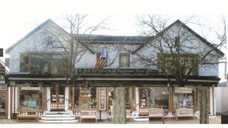
17 Domestic Buildings 2 ½ stories Oversized and exaggerated gables Ground floor nearly 100% glass; less fenestration as you move above Variety of domestic materials Oversized ground floor porches Symmetrical/Tripartite No more than 65 feet in width, max. width of single gable is 31 feet 16


18 Mercantile Buildings 2 and 3 stories Exaggerated horizontal roof line (cornice) Maximum fenestration on ground and second floor Masonry is dominant material Exaggerate height of vertical expression No more than 60 feet in width 17


19 Long Building Types One-story and Multi-story Can be subdivided Anchor corners Variation in materials 18


20 New Office Buildings - Hampton Road 2.5 stories Enlarged domestic character Varied skyline More glass on ground story Wood and masonry Light colors 19
21 Zoning 20

22 Implementation Zoning Zoning will be modified for existing Village Business District There are no changes to the boundaries KEY = Existing Village Business District 21
23 Conceptual Guidelines Zoning Massing o Street Wall Buildings are required to be built at the front property line: At least 90% of the frontage To be built at the ground level, within three feet of the property line On Windmill, to be built within 3 feet of the required setback Maximum setback above first story is 8 feet Maximum length of continuous street wall, without a change in height, is 65 feet Maximum length of one story street wall (up to 20 feet high) is 50 feet Maximum length of street wall, without one story (up to 20 feet high), is 120 feet The ground level street wall shall be recessed to accommodate entrances on a regular basis No continuous wall without a recess can be longer than 45 feet Recesses are to be a minimum of 3 feet in depth Maximum depth of recess cannot exceed 12 feet 22
24 Conceptual Guidelines Zoning Massing o Height Limits No building can be higher than 35 feet or 2.5 stories, except mercantiletype buildings can be three stories (up to 40 feet)» No closer than 150 feet from another building above 35ft» Can be no longer than 60 linear feet, at three stories o Coverage Maximum depth of building footprint is 120 feet from the front property line on Windmill, Nugent and Hill Streets and 75 feet on North Main, Main and Jobs Lane. 23
25 Implementation Zoning Parking o Payment to common parking maintenance fund being considered in lieu of normal required number of spaces o Any and all open space on a parcel has to be used for pooled at-grade parking o New parking is required to have permeable paving Village Lot Potential Pooled Parking Access 24
26 Implementation Zoning Parking Conditions o 1,216 on street and off street parking spaces o maximum of 74% utilized weekdays o maximum of 79% utilized weekends Village Lot Potential Pooled Parking Access 25
27 Implementation Zoning Shared Parking Parking utilized jointly among different buildings and uses to take advantage of different peaks for different uses o business peaks on weekdays o restaurants peak evenings and weekends o New use residential peaks at night Village Lot Potential Pooled Parking Access 26
28 Implementation Zoning Advantages of Shared Parking o More efficient use of space may yield more parking spaces in the same area o Reduces traffic congestion from circuitous searches o Reduce traffic volume from reparking o Increases foot traffic in front of businesses Village Lot Potential Pooled Parking Access 27

29 Implementation Zoning Shared Parking Reductions Village Lot Potential Pooled Parking Access 28
30 Implementation Zoning Ways to Achieve Shared Parking Lots Village negotiates leases, easements or purchase agreements with private landowners o o Leases and easements may require indemnification for property owner Benefits property owner if there is no ongoing maintenance or liability Increases Codify incentives for private Landowners to share lots o o o Tax abatements Density bonuses Waiver of some or all onsite parking requirements Village Lot Potential Pooled Parking Access 29
31 Implementation Zoning Funding Mechanism Special Assessment District/Parking District o o o Pay a tax in lieu of providing onsite parking Credit to property owners that provide onsite parking Tax revenues used to purchase, construct and maintain parking Fees in Lieu of Parking o o o New projects pay a fee for each required space not provided onsite Can be a one-time fee and/or an annual fee Fees used to purchase, construct and maintain parking Village Lot Potential Pooled Parking Access 30
32 Implementation Zoning Required (Ground Level Retail) Uses o Ground Level Retail on Main Street and Jobs Lane o Ground Level Retail is allowed, but not required elsewhere o Offices are allowed on any and all floors (except Main Street and Jobs Lane) o Hotels are allowed on any and all floors (except Main Street and Jobs Lane) o Residential allowed on upper floors only. Village Lot Potential Pooled Parking Access 31

33 Implementation Zoning Vehicular Alleyways o Vehicular alleyway required within 235 feet of intersecting streets and/or another vehicular alleyway New Street o Connect public street to rear parking lots o Vehicles permitted New Street Existing Alleyway Proposed Alleyway 32
34 Implementation Zoning Open Space o None required. Circulation/Curb Cuts o None allowed except for vehicular alleyways every 235 feet. Yards o None required. 33
35 Conceptual Guidelines 34
36 Conceptual Guidelines Summary 35
37 Conceptual Guidelines Design Guidelines Roof & Skyline Fenestration Corners Materials and Colors Canopies Architectural Composition 36
38 Conceptual Guidelines Design Guidelines: Insuring new buildings fit in and are appropriate to the existing village architecture The front street wall is the primary feature that defines the character of Southampton Village No one style or look Always changing o Especially from neighbor to neighbor Lots of ground-floor glass Very commercial White color predominates Cars and parking included in the street scene 37

39 Conceptual Guidelines Roof and Skyline Maximum length of continuous roofline is limited to 65 feet Preferred roof treatment is gabled roofs o A pitched roof in excess of 30 feet in width is to be double gabled o An exception is the mercantile-type building. The roof is flat, no longer than 60 feet, and is specially designed to emphasize the skyline edge No roof can be the same as the roof of an adjacent building(s) 38
40 Conceptual Guidelines Fenestration Minimum 80% on ground floor is required Minimum 50% glass on 2 nd floor Only clear glass is to be used West Side East Side 39


, to be: o")

41 Conceptual Guidelines Corners Street corners are to stand out, by varying the architectural treatment (from two adjacent sides), to be: o Unique in massing, or o Unique in roofline, or o Unique in fenestration 40


42 Conceptual Guidelines Materials and Colors No reflective glass No metal or concrete Mercantile-type buildings are masonry Domestic-type buildings are wood and other materials, common to vernacular houses of Southampton White is to be found on every building (trim or molding satisfies minimum requirement) 41
 Allowed, if fabric, and No more than")

43 Conceptual Guidelines Canopies (ground level) Allowed, if fabric, and No more than 30 feet in length to showcase individual businesses Must be located above glass/storefronts 42
 Most significant expression is set away from adjacent neighbors")
44 Conceptual Guidelines Architectural Composition Each building has its own unique identity as compared to its adjacent neighboring building Organization of façade is in threes Emphasis is on the first story (most fenestration, most variety of materials and colors, most disruption of building envelope) Most significant expression is set away from adjacent neighbors 43
45 Conceptual Guidelines Summary 44
46 Village Center Design Concept 45

47 Village Center Streets & Parking Concepts 46

48 Village Center Village Center Design Concept 47

49 Village Center Village Center Design Concept 48


50 Village Center Village Center Design Concept 49

51 Village Center Village Center Design Concept 50
52 Village Center Village Center Design Concept 51


53 Village Center Village Center Design Concept 52


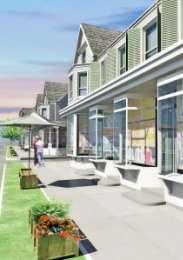
54 Village Center Village Center Design Concept 53

55 Southampton Village Center Vision Plan Key Principles Preserve the unique historic fabric; build new like old Maximize walking throughout Integrate circulation and parking strategy Maintain a year-round, central focus Create improved and sustainable stormwater handling Make art a defining characteristic Emphasize the Village streets and open spaces 54
56 Conclusion The Zoning and Architectural Guidelines contained in this report are critical tools needed for realizing Southampton Village s Vision Plan. To achieve these goals, the zoning guidelines focus on a select number of areas, including the distinctive architectural character of the central Village, the reintroduction of residential zoning, and the strategy of shared parking, among others. The guidelines do not change either the Village s existing zoning boundaries or its current allowable densities; both already support the development goals articulated in the Vision Plan. Important as these zoning guidelines are, implementing the Village s Vision also depends on many other related public actions involving policy making, administrative changes, and capital projects (paid for with public funds). Ultimately, the guidelines will ensure that the Village s future growth is scaled on local precedent and conventional wisdom. By defining the Village s growth as "evolutionary," the Vision offers a way to preserve Southampton Village while building on its unique sense of place. 55

57 Appendix I: Typology Study 56


58 Key Parcels for Typology Study Familiar Iconic Active Admired Relevant Size 57

59 West Side of Main Street 58

60 East Side of Main Street 59

61 West Side Street Wall 60

62 East Side Street Wall 61

63 West Side Alleyway Location 62

64 East Side Alleyway Location 63

65 West Side Skyline 64
66 East Side Skyline 65

67 West Side Maximum Width of Rooftops and Architecture 66

68 East Side Maximum Width 67

69 West Side Heights 68

70 East Side Heights 69

71 West Side Upper Floor Setback 70

72 West Side Fenestration 71

73 East Side Fenestration 72
74 West Side Entrances 73
75 East Side Entrances 74

76 Appendix II: Recommended Zoning Changes 75
77 Business Districts Table of Dimensional Regulations VB Village Business 4 1. Lot area Minimum (square feet) Minimum per dwelling unit (square feet) 2. Lot coverage, maximum coverage by main and accessory buildings and structures (percent) 3. Lot width, minimum (feet) 4. Height, Maximum Stories Feet 5. Yards, principal building, minimum (feet) Front Side, minimum for 1 Side, total for both on interior lot Side, abutting side street on corner lot (on the street designated by the planning Board) Rear 6.Yards, accessory buildings and structures, minimum (feet) Distance from street Distance from rear line Distance from side line 7. Lot coverage, maximum coverage by a one story building (square feet) 8. Lot coverage, maximum coverage by a two story building (square feet) NOTES: 4 Dimensional regulations in the VB District are set forth in
78 Business Districts Table of Use Regulations A. Residential uses VB Village Business 7. Apartments on upper floors in the VB District SE C. General Community Facilities 6. Medical arts building P 2 D. Business Uses 3. Auditorium, meeting hall SE 12. Hotel, motel, transient SE Office: business, utility or professional (except that offices and facilities for veterinarians are prohibited in the HA Hospital Accessory District) 32. Offices for a licensed health-care professional (except that offices and facilities for veterinarians are prohibited in the HA Hospital Accessory District) P 2 P 2 F. Accessory Uses 3. Home occupation other than home professional office SE 4. Home professional office SE 9. Private swimming pool SE 2 Permitted on upper floors only on Main Street and Jobs Lane, and on all floors on other streets. 3 This special exception use (transient hotel or motel use) shall be limited to property located outside of a designated historic district under Chapter 65 of the Village Code. 77
79 Zoning Code Text Changes Dimensional regulations in VB district. A. Lot area. (1) Where public sewerage is not available, no lot shall be built upon which has insufficient space for a private sanitary waste disposal system, as determined by the municipality and the Suffolk County Health Department. (2) No minimum lot area required. (3) No minimum lot area per dwelling unit required. B. Lot width. (1) Minimum lot width shall be 20 feet C. Lot Coverage. (1) Maximum coverage by main and accessory buildings and structures shall be 70 percent. (2) Maximum depth of building footprint from front property line shall be 75 feet for lots with frontage on North Main, Main and Jobs Lane. (3) Maximum depth of building footprint from front property line shall be 120 feet for lots with frontage on all streets other than North Main Street, Main, and Jobs Lane. D. Height. (1) With respect to property located in a designated historic district under Chapter 65 of the Village Code, maximum building height shall be 35 feet and maximum stories shall be 2 ½ stories. (2) With respect to property located outside of a designated historic district under Chapter 65 of the Village Code, maximum building height shall be 35 feet and maximum stories shall be 2 ½ stories unless special exception approval is obtained from the Board of Appeals to exceed such limitations. Subject to the limitation set forth in subsection D(3), the Board of Appeals may grant special exception approval to exceed 35 feet in height in order to allow a height not exceeding 40 feet, and in conjunction therewith, the Board of Appeals may grant special exception approval to exceed 2 ½ stories in order to allow 3 stories. (3) One or more adjacent buildings above 35 feet in height shall not continue more than 60 feet along the street, or be located within 150 feet of another building above 35 feet in height. (4) Building height of one or more adjacent buildings shall not remain constant for more than 65 feet along the street. A change in building height shall consist of a minimum of three feet. (5) Maximum height of a single story building is 20 feet. One or more adjacent single story buildings shall continue for no more than 50 feet along the street. (6) One or more adjacent multiple story buildings shall not continue for more than 120 feet along the street without an eight foot setback of the upper story(ies). E. Yards for principal buildings and accessory buildings. (1) No minimum yard setbacks are required. (2) Maximum front yard setback for first story is three feet. (3) Principal building must span a minimum of 90% of the frontage. 78
80 Zoning Code Text Changes (4) Where a drainage easement is required, front yard setback shall be measured from the easement. (5) Maximum front yard setback for upper stories is eight feet beyond the first story setback. (6) Recesses to accommodate entrances shall be a minimum of three feet and a maximum of twelve feet in depth and shall be provided at intervals of no more than 45 feet Off-street parking, truck loading space and curb cut construction. See Appendix IV. K. VB District. (1) In accordance with the 2012 Village Master Plan Update and B.(2), in order to eliminate multiple entrances and exits, reduce traffic hazards, gain a higher efficiency in vehicular and pedestrian circulation, conserve space and to promote orderly development, shared parking facilities shall be provided between adjacent lots to serve a number of uses in such a manner as to obtain the maximum efficiency in parking and vehicular circulation, except where it is not physically feasible. (2) Shared alleyways for pedestrian and/or vehicular traffic shall be provided to connect public streets to parking areas to the rear of buildings. Alleyways shall be provided a maximum of 235 feet from the nearest intersection or alleyway and shall include a minimum sidewalk depth of five feet. (3) Vehicular access to parking areas shall be provided by shared alleyways in lieu of individual lot curb cuts. (4) Permeable pavement shall be used for all alleyways and parking areas. (5) Parking requirements shall be 60% of the spaces set forth in D. Schedule of off-street parking space requirements for nonresidential uses. (6) Parking requirements for residential uses shall be 1 space for a one bedroom unit, 1.5 spaces for a two-bedroom unit, and an additional 0.5 space for each additional bedroom. ARTICLE IV Special Exception Uses ( ) Special conditions and safeguards for certain uses. B. List of uses. (19) Philanthropic, fraternal, social or educational institution office or meeting room, nonprofit. (a) In any district, the lot area shall be not less than three acres nor shall the frontage be less than 200 feet on a street (not applicable in VB district). (26) Apartments on upper floors in the VB District (a) One or more apartments (dwelling units) may be allowed on upper floors only. (b) No apartment (dwelling unit) shall be provided on the first floor. (c) Provisions shall be made for proper sanitary waste disposal and water supply facilities in conformance with the requirements of the Suffolk County Department of Health Services, and such facilities shall be designed to protect the groundwater reservoir from pollution, saltwater intrusion or excessive demand detrimental to the environment and neighboring properties. 79
81 Zoning Code Text Changes (d) With respect to property located in a designated historic district under Chapter 65 of the Village Code, such use shall be limited to existing (as of January 1, 2011) building floor area unless it is determined by the Board of Appeals that any proposed development or redevelopment of new or additional building floor area will be compatible with the historic character of such existing building and such historic district. In the case of any such proposed development or redevelopment, the Board of Appeals shall refer the application for special exception use approval to the Board of Architectural Review and Historic Preservation for its report and comments before any determination by the Board of Appeals. (e) The maximum floor area of a one bedroom apartment shall be 800 square feet. The maximum floor area of a two bedroom apartment shall be 1,250 square feet. No apartment shall contain more than two bedrooms. 80
82 Appendix III: Zoning Map 81

83 Zoning Map 82
84 Appendix IV: Historic District Map 83

85 Historic District Map 84

86 Appendix V: Shared Parking Report 85

87 Shared Parking Report 86

88 Shared Parking Report 87

89 Shared Parking Report 88

90 Shared Parking Report 89

91 Shared Parking Report 90

92 Shared Parking Report 91

93 Shared Parking Report 92

94 Shared Parking Report 93

95 Shared Parking Report 94

96 Shared Parking Report 95

97 Shared Parking Report 96

98 Shared Parking Report 97
99 Shared Parking Report 98

100 Shared Parking Report 99

101 Shared Parking Report 100

102 Shared Parking Report 101

103 Shared Parking Report 102

104 Shared Parking Report 103
105 Shared Parking Report 104
106 Shared Parking Report 105

107 Shared Parking Report 106
108 Shared Parking Report 107
109 Shared Parking Report 108

110 Shared Parking Report 109

111 Shared Parking Report 110

112 Shared Parking Report 111

113 Shared Parking Report 112

114 Shared Parking Report 113

115 Shared Parking Report 114

116 Shared Parking Report 115
117
Composition of traditional residential corridors.
 Page 1 of 7 St. Petersburg, Florida, Code of Ordinances >> PART II - ST. PETERSBURG CITY CODE >> Chapter 16 - LAND DEVELOPMENT REGULATIONS >> SECTION 16.20.060. CORRIDOR RESIDENTIAL TRADITIONAL DISTRICTS
LOT AREA AND FRONTAGE
 LOT AREA AND FRONTAGE Lot Area & Frontage for the R2.1 Zone Lot Area & Frontage for the R2.4 Zone Minimum Lot Minimum Lot Zone Area Width R2.1 700 sq m 18 m R2.4 600 sq m 16 m Lot Area means the total
DEVELOPMENT STANDARDS FOR RESIDENTIAL PROJECTS RESIDENTIAL BUILDING TYPES: APPROPRIATE ZONES AND DENSITIES 2-1
 2 DEVELOPMENT STANDARDS FOR RESIDENTIAL PROJECTS RESIDENTIAL BUILDING TYPES: APPROPRIATE ZONES AND DENSITIES 2-1 This Chapter presents the development standards for residential projects. Section 2.1 discusses
CITY OF MERCED SMALL LOT SINGLE-FAMILY HOME DESIGN GUIDELINES
 CITY OF MERCED SMALL LOT SINGLE-FAMILY HOME DESIGN GUIDELINES Development Services Department Planning and Permitting Adopted August 15, 2005 SMALL LOT SINGLE FAMILY HOME GUIDELINES A. Purpose and Applicability.
Table of Contents ARTICLE 5A CHARACTER-BASED ZONING 1
 Table of Contents ARTICLE 5A CHARACTER-BASED ZONING 1 SECTION 10.5A10 GENERAL... 1 10.5A11 Purpose and Intent... 1 10.5A12 Applicability... 1 10.5A13 Compliance with Regulating Plan... 1 10.5A14 Relationship
Table of Contents ARTICLE 5A CHARACTER-BASED ZONING 1
 Table of Contents ARTICLE 5A CHARACTER-BASED ZONING 1 SECTION 10.5A10 GENERAL... 1 10.5A11 Purpose and Intent... 1 10.5A12 Applicability... 1 10.5A13 Compliance with Regulating Plan... 1 10.5A14 Relationship
Anacortes, WA. 718 commercial ave. FOR lease. 2,320 +/- sf retail space in a 10,820 +/- sf building. Located in historic downtown Anacortes
 718 commercial ave Anacortes, WA FOR lease 2,320 +/- sf retail space in a 10,820 +/- sf building Located in historic downtown Anacortes Frontage on Commercial Ave alongside four other retail spaces Zoned
CASTLES OF CALEDON URBAN DESIGN REPORT
 CASTLES OF CALEDON URBAN DESIGN REPORT PROPOSED RESIDENTIAL DEVELOPMENT CALEDON, ONTARIO 10 JULY, 2015 TABLE CONTENTS: 1.0 DEVELOPMENT 4.0 CONCLUSION 1.1 Introduction 1.2 Castles of Caledon- Urban Design
Sedro woolley, WA 720 MURDOCK ST. FOR sale. 14,500 +/- sf office building with 8,500 +/- sf unfinished basement space on 0.
 720 MURDOCK ST Sedro woolley, WA FOR sale 14,500 +/- sf office building with 8,500 +/- sf unfinished basement space on 0.27 +/- AC Former City Hall built in 1930 Located in the Downtown Sedro Woolley core
ARTICLE 10 SPECIAL PURPOSE DISTRICTS
 ARTICLE 10 SPECIAL PURPOSE DISTRICTS Sec. 29.1000. SPECIAL PURPOSE DISTRICTS. (1) Purpose. Each Special Purpose District will appear on the City's Zoning Map as a Base Zone. The Special Purpose Districts
SECTION 73 CHESTER VILLAGE DISTRICT REGULATIONS
 SECTION 73 CHESTER VILLAGE DISTRICT REGULATIONS 73.1 AUTHORITY 73.1.1 Authority and Uniformity. It is the intention of the Commission to adopt use regulations and design standards for the area known as
PLANNING RATIONALE REPORT
 PLANNING RATIONALE REPORT Zoning By-law Amendment Application 2920 Danbury Way Prepared for: Bravar Custom Builders Inc. and Village View Estates Ltd. by: 6393 Roslyn Street Ottawa (Orleans), Ontario K1C
PLANNING REPORT Gordon Street City of Guelph. Prepared on behalf of Ontario Inc. March 17, Project No. 1507
 PLANNING REPORT 1131 Gordon Street City of Guelph Prepared on behalf of 1876698 Ontario Inc. March 17, 2016 Project No. 1507 423 Woolwich Street, Suite 201, Guelph, Ontario, N1H 3X3 Phone (519) 836-7526
Part 4.0 DEVELOPMENT REGULATIONS
 M A I N S T R E E T N O R T H Part 4.0 DEVELOPMENT REGULATIONS 4.1 Districts 4.2 Permitted and Prohibited Uses, Standards and Standard Specific Criteria and Other General Provisions 4.3 DPS REGULATIONS
The Cannery Marketplace Narrative. Purpose: Site Design Approach: Cannery Commerce District 10/18/2017
 The Cannery Marketplace Narrative Cannery Commerce District 10/18/2017 Purpose: A number of entitlements are being requested for the Cannery Marketplace inclusive of a Master Conditional Use Permit (Master
DEVELOPMENT DEPARTMENT STAFF REPORT STAFF REPORT DRESDEN DRIVE TOWNHOMES DCI
 DEVELOPMENT DEPARTMENT STAFF REPORT Meeting Date: September 13, 2018 Item #: PZ2018-319 STAFF REPORT DRESDEN DRIVE TOWNHOMES DCI Request: Project Name: Development of Community Compact (DCI) and six concurrent
PLANNED UNIT DEVELOPMENT & SUBDIVISION STAFF REPORT Date: April 18, 2019
 PLANNED UNIT DEVELOPMENT & SUBDIVISION STAFF REPORT Date: April 18, 2019 DEVELOPMENT NAME SUBDIVISION NAME Springhill Village Subdivision Springhill Village Subdivision LOCATION 4350, 4354, 4356, 4358,
Puyallup Downtown Planned Action & Code Changes. January 10, 2017
 Puyallup Downtown Planned Action & Code Changes January 10, 2017 Purpose & Location Purpose Promote economic development and downtown revitalization Tools: Municipal Code amendments Change development
Glades County Staff Report and Recommendation Unified Staff Report for Small Scale Plan Amendment and Rezoning
 Glades County Staff Report and Recommendation Unified Staff Report for Small Scale Plan Amendment and Rezoning CASE NUMBERS: COMP17-02 and RZ17-02 DATE of STAFF REPORT: May 1, 2017 CASE TYPE: Application
DIVISION 7. R-6 AND R-6A RESIDENTIAL ZONES* The purpose of the R-6 residential zone is:
 Date of Draft: March 6, 2015 DIVISION 7. R-6 AND R-6A RESIDENTIAL ZONES* Sec. 14-135. Purpose. The purpose of the R-6 residential zone is: (a) To set aside areas on the peninsula for housing characterized
City Wide Design Guidelines Attachment A Proposed Ordinance
 City Wide Design Guidelines Attachment A Proposed Ordinance ORDINANCE NO. Adopted by the Sacramento City Council Date Adopted AN ORDINANCE AMENDING SECTIONS 17.600.100, 17.600.105, 17.600.110, AND 17.600.125
Article 3. SUBURBAN (S-) NEIGHBORHOOD CONTEXT
 NEIGHBORHOOD CONTEXT") Article 3. SUBURBAN (S-) NEIGHBORHOOD CONTEXT this page left intentionally blank Contents ARTICLE 3. SUBURBAN (S-) NEIGHBORHOOD CONTEXT DIVISION 3.1 NEIGHBORHOOD CONTEXT DESCRIPTION...3.1-1 Section 3.1.1
Article 3. SUBURBAN (S-) NEIGHBORHOOD CONTEXT this page left intentionally blank Contents ARTICLE 3. SUBURBAN (S-) NEIGHBORHOOD CONTEXT DIVISION 3.1 NEIGHBORHOOD CONTEXT DESCRIPTION...3.1-1 Section 3.1.1
David J. Gellner, AICP, Principal Planner, ,
 Staff Report PLANNING DIVISION COMMUNITY & ECONOMIC DEVELOPMENT To: From: Salt Lake City Planning Commission David J. Gellner, AICP, Principal Planner, 801-535-6107, david.gellner@slcgov.com Date: March
CHAPTER 14 PLANNED UNIT DEVELOPMENTS
 9-14-1 9-14-1 CHAPTER 14 PLANNED UNIT DEVELOPMENTS SECTION: 9-14-1: Purpose 9-14-2: Governing Provisions 9-14-3: Minimum Area 9-14-4: Uses Permitted 9-14-5: Common Open Space 9-14-6: Utility Requirements
PERMITTED USES: Within the MX-1 Mixed Use Neighborhood District the following uses are permitted:
 6.25 MX-1 - MIXED USE NEIGHBORHOOD 6.25.1 INTENT: The purpose of the MX-1 Mixed Use Neighborhood District is to accommodate the development of a wide-range of residential and compatible non-residential
LITTLE MOUNTAIN ADJACENT AREA REZONING POLICY
 LITTLE MOUNTAIN ADJACENT AREA REZONING POLICY JANUARY 2013 CONTENTS 1.0 INTENT & PRINCIPLES...1 2.0 APPLICATION...2 3.0 HOUSING TYPES, HEIGHT & DENSITY POLICIES...3 3.1 LOW TO MID-RISE APARTMENT POLICIES...4
May 12, Chapter RH HILLSIDE RESIDENTIAL ZONES REGULATIONS Sections:
 May 12, 2017 Chapter 17.13 RH HILLSIDE RESIDENTIAL ZONES REGULATIONS Sections: 17.13.010 Title, intent, and description. 17.13.020 Required design review process. 17.13.030 Permitted and conditionally
ARTICLE 23 CONDOMINIUM STANDARDS
 ARTICLE 23 CONDOMINIUM STANDARDS Section 23.01 Intent. The intent of this Article is to provide regulatory standards for condominiums and site condominiums similar to those required for projects developed
ARTICLE FIVE FINAL DRAFT
 ARTICLE FIVE 021218 FINAL DRAFT Sec. 503.6 Open Space Preservation Option Open Space Preservation Option Open Space Preservation developments may be approved in the AR, R-1, R-2 and R-3 zoning districts,
8.5.1 R1, Single Detached Residential District
 8.5.1 R1, Single Detached Residential District The purpose of this district is to provide for residential development in the form of single detached dwellings. Dwelling, Single Detached Home Business,
M-43 CORRIDOR OVERLAY ZONE
 ARTICLE 26.00 M-43 CORRIDOR OVERLAY ZONE Section 26.01 Findings A primary function of the M-43 state highway is to move traffic through the Township and to points beyond. As the primary east-west arterial
AN ORDINANCE OF THE CITY OF MINNEAPOLIS. By Palmisano
 AN ORDINANCE OF THE CITY OF MINNEAPOLIS By Palmisano Amending Title 20, Chapter 520 of the Minneapolis Code of Ordinances relating to Zoning Code: Introductory Provisions. The City Council of the City
Town of Gorham Development Transfer Fee Program SECTION XVIII DEVELOPMENT TRANSFER OVERLAY DISTRICT
 Town of Gorham Development Transfer Fee Program SECTION XVIII DEVELOPMENT TRANSFER OVERLAY DISTRICT [Note: The Development Transfer Overlay District (a Development Transfer Fee program) is included as
a. To insure compatible relationships between land use activities;
 PART B SECTION VIII INSTITUTIONAL DISTRICTS Article 1 Planned Institutional District 1. Purpose and Intent: It is the purpose and intent of this district to permit and encourage the orderly, cooperative
ARTICLE SCHEDULE OF REGULATIONS
 ARTICLE 21.00 SCHEDULE OF REGULATIONS FOOTNOTES TO ARTICLE 21.00 SCHEDULE OF REGULATIONS a. If one or both public sanitary sewers and/or public water supply are not available minimum lot size shall be
Washington County, Minnesota Ordinances
 Washington County, Minnesota Ordinances Ordinance No. 153 Text Amendment to the Washington County Development Code - Chapter One, Section 2 and Chapter Two, Part 1, Part 2, Part 3, of the Development Code
COMMISSION ACTION FORM SUBJECT: ZONING TEXT AMENDMENT FOR LINCOLN WAY CORRIDOR PLAN DOWNTOWN GATEWAY COMMERCIAL ZONING DISTRICT STANDARDS
 ITEM #: 7 DATE: _02-07-18 COMMISSION ACTION FORM SUBJECT: ZONING TEXT AMENDMENT FOR LINCOLN WAY CORRIDOR PLAN DOWNTOWN GATEWAY COMMERCIAL ZONING DISTRICT STANDARDS BACKGROUND: The Downtown Gateway area
Medical Marijuana Special Exception Use Information
 Medical Marijuana Special Exception Use Information The Special Exception Use information below is a modified version of the Unified Development Code. It clarifies the current section 5:104 Special Exceptions
ARTICLE 7 R-1 LOW DENSITY ONE-FAMILY RESIDENTIAL DISTRICT Updated 5/4/13
 ARTICLE 7 R-1 LOW DENSITY ONE-FAMILY RESIDENTIAL DISTRICT Updated 5/4/13 Sec. 7.01. DESCRIPTION AND PURPOSE. This is the most restricted, low-density zone, composed chiefly of low-density one-family homes
 Page 1 of 8 Laguna Beach Municipal Code Up Previous Next Main Collapse Search Print No Frames Title 25 ZONING Chapter 25.10 R-1 RESIDENTIAL LOW DENSITY ZONE 25.10.002 Intent and purpose. This zone is intended
4 DEVELOPMENT STANDARDS FOR
 4 DEVELOPMENT STANDARDS FOR RESIDENTIAL MIXED-USE PROJECTS This chapter presents standards for residential mixed-use projects in the Ashland-Cherryland Business District and the Castro Valley Central Business
PART 3 RESIDENTIAL ZONING DISTRICTS. Designation of Residential Zoning Districts and Purpose Statements.
 PART 3 S Section 301. Designation of and Purpose Statements. See Table 3-1 herein this Section for the designations and purpose statements of the respective Residential Zoning Districts which are shown
UPPER MOUNT BETHEL TOWNSHIP NORTHAMPTON COUNTY, PENNSYLVANIA
 UPPER MOUNT BETHEL TOWNSHIP NORTHAMPTON COUNTY, PENNSYLVANIA JOINDER DEED / LOT CONSOLIDATION TOWNSHIP REVIEW PROCESS When accepting proposed Joinder Deeds / Lot Consolidations, review the Joinder Deed
Appendix1,Page1. Urban Design Guidelines. Back to Back and Stacked Townhouses. DRAFT September 2017
 Appendix1,Page1 Urban Design Guidelines DRAFT September 2017 Back to Back and Stacked Townhouses Appendix1,Page2 Table of Contents 1 Introduction 1 1.1 Purpose 1 1.2 Urban Design Objectives 1 1.3 Building
New Zoning Ordinance Program
 City of Goleta New Zoning Ordinance Program Module 3: Regulations Applying to Multiple Districts General Site Regulations Landscaping Parking and Loading June 09, 2014 New Zoning Ordinance Program By:
BOROUGH OF HOPATCONG ORDINANCE No
 BOROUGH OF HOPATCONG ORDINANCE No. 10-2014 AN ORDINANCE OF THE BOROUGH OF HOPATCONG, SUSSEX COUNTY, NEW JERSEY TO ADOPT A FORM BASED CODE AS AN OVERLAY DISTRICT AFFECTING PORTIONS OF THE B-1 AND R-1 ZONING
(1) The following uses are permitted uses subject to:
 The following uses are permitted uses subject to:") SECTION 4 - RESIDENTIAL SECOND DENSITY (R2) ZONE PURPOSE OF THE ZONE The purpose of the R2 Residential Second Density Zone is to: () restrict the building form to low density residential uses in areas
SECTION 4 - RESIDENTIAL SECOND DENSITY (R2) ZONE PURPOSE OF THE ZONE The purpose of the R2 Residential Second Density Zone is to: () restrict the building form to low density residential uses in areas
Bulk Requirements (For other supplementary location and bulk regulations, see Article VII.)
") 4.13 TOWNSITE OVERLAY DISTRICT (TO) 4.13.1 Purpose The purpose of the Townsite Overlay District is to promote the health, safety and welfare of current and future residents of the City of Hailey; to modify
4.13 TOWNSITE OVERLAY DISTRICT (TO) 4.13.1 Purpose The purpose of the Townsite Overlay District is to promote the health, safety and welfare of current and future residents of the City of Hailey; to modify
Sherwood Forest (Trinity) Housing Corporation. Urban Design Brief
 Housing Corporation. Urban Design Brief") Sherwood Forest (Trinity) Housing Corporation Sherwood Place Affordable Housing Apartments Trinity Presbyterian Church Orchard Park Nursery School 590 Gainsborough Road, London Urban Design Brief REVISED
Sherwood Forest (Trinity) Housing Corporation Sherwood Place Affordable Housing Apartments Trinity Presbyterian Church Orchard Park Nursery School 590 Gainsborough Road, London Urban Design Brief REVISED
900 BURRARD STREET CD-1 GUIDELINES (BY-LAW NO. 6421) (CD-1 NO. 229) CONTENTS. 1 Application and Intent... 1
 (CD-1 NO. 229) CONTENTS. 1 Application and Intent... 1") 50 City of Vancouver Land Use and Development Policies and Guidelines Community Services, 453 W. 12th Ave Vancouver, BC V5Y 1V4 F 604.873.7344 fax 873.7060 planning@city.vancouver.bc.ca 900 BURRARD STREET
50 City of Vancouver Land Use and Development Policies and Guidelines Community Services, 453 W. 12th Ave Vancouver, BC V5Y 1V4 F 604.873.7344 fax 873.7060 planning@city.vancouver.bc.ca 900 BURRARD STREET
PLANNING COMMISSION REPORT Regular Agenda -Public Hearing Item
 PDP-13-00518 Item No. 3B- 1 PLANNING COMMISSION REPORT Regular Agenda -Public Hearing Item PC Staff Report 2/24/14 ITEM NO. 3B PRELIMINARY DEVELOPMENT PLAN FOR HERE @ KANSAS; 1101 INDIANA ST (SLD) PDP-13-00518:
DEVELOPMENT DEPARTMENT STAFF REPORT DRESDEN HEIGHTS PHASE II DCI
 DEVELOPMENT DEPARTMENT Meeting Date: January 10, 2019 Item #: PZ2019-393 Project Name: Applicant and Owner: Proposed Development: Requests: STAFF REPORT DRESDEN HEIGHTS PHASE II DCI Dresden Heights Phase
Wilson Bridge Corridor Zoning. Department of Planning & Building
 Wilson Bridge Corridor Zoning Department of Planning & Building Background: Wilson Bridge Road Corridor Study The City conducted a strategic study of one of the community s primary economic centers, the
SECTION 822 "R-1-A" AND "R-1-AH" - SINGLE FAMILY RESIDENTIAL DISTRICTS
 SECTION 822 "R-1-A" AND "R-1-AH" - SINGLE FAMILY RESIDENTIAL DISTRICTS The "R-1-A" and "R-1-AH" Districts are intended to provide for the development of single family residential homes at urban standards
Urban Design Brief. Proposed Medical / Dental Office 1444 Adelaide Street North. Vireo Health Facility Ltd.
 Urban Design Brief Proposed Medical / Dental Office Vireo Health Facility Ltd. November 27, 2013 TABLE OF CONTENTS Page No. INTRODUCTION... 1 SECTION 1 LAND USE PLANNING CONTEXT... 1 1.1 The Subject Lands...
FOR SALE > MULTIFAMILY/COMMERCIAL REDEVELOPMENT OPPORTUNITY
 FOR SALE > MULTIFAMILY/COMMERCIAL REDEVELOPMENT OPPORTUNITY 2220 W. Cary Street RICHMOND, VA 23220 CURRENT PROPERTY ILLUSTRATION CONCEPTUAL ONLY (NOT PROPOSED) Property Information Zoning: R-63, Multifamily
Request Subdivision Variance (4.1 (m)(1) of the Subdivision Regulations) Staff Recommendation Approval. Staff Planner Jonathan Sanders
(1) of the Subdivision Regulations) Staff Recommendation Approval. Staff Planner Jonathan Sanders") Applicant Property Owner Jo Stallard Woolling Hodges Public Hearing December 12, 2018 (Deferred November 14, 2018) City Council Election District Beach Agenda Item D4 Request Subdivision Variance (4.1
Applicant Property Owner Jo Stallard Woolling Hodges Public Hearing December 12, 2018 (Deferred November 14, 2018) City Council Election District Beach Agenda Item D4 Request Subdivision Variance (4.1
Plan Dutch Village Road
 Plan Dutch Village Road Objective: The lands around Dutch Village Road are a minor commercial area that services the larger Fairview community. Maintaining the vibrancy of the area by planning for redevelopment
ORDINANCE NO
 APPROVED BY ORANGE COUNTY BOARD OF COUNTY COMMISSIONERS BCC Mtg. Date: May 24, 2016 EFFECTIVE DATE June 1, 2016 ORDINANCE NO. 2016-10 AN ORDINANCE AFFECTING THE USE OF LAND IN ORANGE COUNTY, FLORIDA; AMENDING
SUBDIVISION DESIGN PRINCIPLES AND STANDARDS
 SECTION 15-200 SUBDIVISION DESIGN PRINCIPLES AND STANDARDS 15-201 STREET DESIGN PRINCIPLES 15-201.01 Streets shall generally conform to the collector and major street plan adopted by the Planning Commission
ARTICLE 4: SCHEDULE OF DISTRICT, USE AND SETBACK REGULATIONS
 Page 1 of 48 City of Hollywood Zoning and Land Development Regulations 4.6.I Beach Community Redevelopment Districts. 1. Purpose. To establish development standards for the Beach Community Redevelopment
DEVELOPMENT DEPARTMENT STAFF REPORT THE PARK AT 5 TH
 DEVELOPMENT DEPARTMENT STAFF REPORT ARB Meeting Date: July 3, 2018 Item #: _PZ2018-293_ THE PARK AT 5 TH Request: Site Address: Project Name: Parcel Number: Applicant: Proposed Development: Current Zoning:
A By-law to amend Zoning and Development By-law No regarding Laneway Houses
 Zoning & Development By-law Amendments regarding Laneway Houses Draft for Public Hearing A By-law to amend Zoning and Development By-law No. 3575 regarding Laneway Houses 1. This By-law amends or adds
Action Recommendation: Budget Impact:
 City of Fayetteville Staff Review Form Garner Stoll Submitted By 2018-0144 Legistar File ID 4/17/2018 City Council Meeting Date - Agenda Item Only N/A for Non-Agenda Item 3/22/2018 Submitted Date Action
City of Fayetteville, Arkansas Page 1 of 3
 City of Fayetteville, Arkansas 113 West Mountain Street Fayetteville, AR 72701 (479) 575-8323 Legislation Text File #: 2018-0144, Version: 1 ADM 18-6094 (AMEND UDC 164.19/ACCESSORY DWELLING UNITS): AN
PLANNING & ZONING DEPARTMENT Town Hall Annex, 66 Prospect St., Ridgefield, CT Fax
 PLANNING & ZONING DEPARTMENT Town Hall Annex, 66 Prospect St., Ridgefield, CT 06877 203-431-2766 Fax 203-431-2737 ADOPTED AMENDMENT TO THE ZONING REGULATIONS NEW Section 5.6 Neighborhood Business Zone
serving retail on the ground floor street frontage with offices and housing above and behind. Purpose and Intent: To create a vibrant pedestrian
 Community Mixed Use (CM) Zone Purpose and Intent: To create a vibrant pedestrian and bicycle-oriented commercial district with high quality public spaces and comprised of community serving retail on the
Draft for Public Review. The Market and Octavia Neighborhood Plan
 Draft for Public Review The Market and Octavia Neighborhood Plan San Francisco Planning Department As Part of the Better Neighborhoods Program December 00 . Housing People OBJECTIVE.1 MIXED-USE RESIDENTIAL
Conditional Use Permit case no. CU 14-06: Bristol Village Partners, LLC
 PLANNING AND ZONING COMMISSION STAFF REPORT August 7, 2014 Conditional Use Permit case no. CU 14-06: Bristol Village Partners, LLC CASE DESCRIPTION: LOCATION: LEGAL DESCRIPTION: EXISTING LAND USE: ZONING:
4.2 RESIDENTIAL ZONING DISTRICTS
 4.2 RESIDENTIAL ZONING DISTRICTS A. Purpose: To define regulations and standards for each residential zoning district in the City. The following sections identify uses, regulations, and performance standards
The following regulations shall apply in the R-E District:
 "R-E" RESIDENTIAL ESTATE DISTRICT (8/06) The following regulations shall apply in the R-E District: 1. Uses Permitted: The following uses are permitted. A Zoning Certificate may be required as provided
ARTICLE 24 SITE PLAN REVIEW
 ARTICLE 24 SITE PLAN REVIEW 24.1 PURPOSE: The intent of these Ordinance provisions is to provide for consultation and cooperation between the land developer and the Township Planning Commission in order
A DJUSTMENTS. A. Zoning Permits Required: Use Permit to construct a dwelling unit, as required by BMC Section 23D
 Z O N I N G A DJUSTMENTS B O A R D S t a f f R e p o r t FOR BOARD ACTION AUGUST 14, 2008 2421 Ninth Street Use Permit 05-10000084 to construct a two-story 1,766 sq. ft., detached dwelling unit at the
SECTION 16. "PUD" PLANNED UNIT DEVELOPMENT OVERLAY DISTRICT
 SECTION 6. "PUD" PLANNED UNIT DEVELOPMENT OVERLAY DISTRICT Subsection. Purpose. This district is established to achieve the coordinated integration of land parcels and large commercial and retail establishments
Rezoning Petition Pre-Hearing Staff Analysis April 17, 2017
 Rezoning Petition 2017-041 Pre-Hearing Staff Analysis April 17, 2017 REQUEST Current Zoning: R-5 (single family residential), R-22MF (multifamily residential), and I-1 (light industrial) Proposed Zoning:
ARTICLE 15. RULES, REGULATIONS AND DEFINITIONS
 ARTICLE 15. RULES, REGULATIONS AND DEFINITIONS Section 1. Interpretation and Construction: The following rules and regulations regarding interpretation and construction of the Ulysses-Grant County, Kansas,
COMMERCIAL ZONING DISTRICTS (Amended 11/13/14) Part I. C-1 Restricted Commercial District
 Part I. C-1 Restricted Commercial District") ARTICLE XI. COMMERCIAL ZONING DISTRICTS (Amended 11/13/14) Part I. C-1 Restricted Commercial District Section 152: Purpose This district is designed to accommodate commercial uses which act as a transition
ARTICLE XI. COMMERCIAL ZONING DISTRICTS (Amended 11/13/14) Part I. C-1 Restricted Commercial District Section 152: Purpose This district is designed to accommodate commercial uses which act as a transition
LAND USE PLANNING TRANSPORTATION PLANNING PROJECT MANAGEMENT
 Memorandum LAND USE PLANNING TRANSPORTATION PLANNING PROJECT MANAGEMENT Date: November 2, 2016 To: From: cc: Re: Cindy Walbridge, Kevin Liburdy, and Jennifer Kaden, City of Hood River Cathy Corliss, AICP,
PLANNING COMMISSION STAFF REPORT
 PLANNING COMMISSION STAFF REPORT AMENDMENTS TO CHAPTER 21A.40.050: 5 Foot Maximum Rear Setback for Accessory Structures Case # 4 April 2011 Planning and Zoning Division Department of Community and Economic
Indicates Council-recommended changes Introduced by: Mr. Tackett Date of introduction: June 14, 2016 SUBSTITUTE NO. 1 TO ORDINANCE NO.
 Indicates Council-recommended changes Introduced by: Mr. Tackett Date of introduction: June 14, 2016 SUBSTITUTE NO. 1 TO ORDINANCE NO. 16-067 TO AMEND NEW CASTLE COUNTY CODE CHAPTER 40 (ALSO KNOWN AS THE
Section 7.22: Multifamily Assisted Housing in AA-30 Residential Zone (MAHZ) [Note: an additional line will be added to the Table in Article 3, 3.1.
 [Note: an additional line will be added to the Table in Article 3, 3.1.") Section 7.22: Multifamily Assisted Housing in AA-30 Residential Zone (MAHZ) [Note: an additional line will be added to the Table in Article 3, 3.1.1A] 7.22.1 Purpose The purpose of this Special Regulation
Section 7.22: Multifamily Assisted Housing in AA-30 Residential Zone (MAHZ) [Note: an additional line will be added to the Table in Article 3, 3.1.1A] 7.22.1 Purpose The purpose of this Special Regulation
ANCHORAGE, ALASKA AO No (S)
") Submitted by: Chair of the Assembly at the Request of the Mayor Prepared by: Planning Department For reading: May, 0 ANCHORAGE, ALASKA AO No. 0- (S) 0 0 0 AN ORDINANCE AMENDING ANCHORAGE MUNICIPAL CODE
Submitted by: Chair of the Assembly at the Request of the Mayor Prepared by: Planning Department For reading: May, 0 ANCHORAGE, ALASKA AO No. 0- (S) 0 0 0 AN ORDINANCE AMENDING ANCHORAGE MUNICIPAL CODE
17.13 RH HILLSIDE RESIDENTIAL ZONES REGULATIONS SECTIONS:
 Effective April 14, 2011 Chapter 17.13 RH HILLSIDE RESIDENTIAL ZONES REGULATIONS SECTIONS: 17.13.010 Title, Intent, and Description 17.13.020 Required Design Review Process 17.13.030 Permitted and Conditionally
Urban Design Brief (Richmond) Corp. 1631, 1635, 1639, 1643 and 1649 Richmond Street City of London
 Corp. 1631, 1635, 1639, 1643 and 1649 Richmond Street City of London") Urban Design Brief 1635 (Richmond) Corp. 1631, 1635, 1639, 1643 and 1649 Richmond Street City of London Site Plan Control Application Holding Provision Application April 1, 2015 Prepared for: Rise Real
Urban Design Brief 1635 (Richmond) Corp. 1631, 1635, 1639, 1643 and 1649 Richmond Street City of London Site Plan Control Application Holding Provision Application April 1, 2015 Prepared for: Rise Real
City of Coral Gables Planning and Zoning Staff Report
 City of Coral Gables Planning and Zoning Staff Report Applicant: Application: Public Hearing: Date & Time: Location: City of Coral Gables Zoning Code Text Amendment Giralda Plaza Overlay District Planning
Ann Arbor Downtown Zoning Evaluation
 Ann Arbor Downtown Zoning Evaluation Options Workbook ENP & Associates in cooperation with the City of Ann Arbor September, 2013 Photo Courtesy of Andrew Horne, February 9, 2013 Introduction Thank you
DRAFT -- PROPOSED EXPANSION AND REVISIONS TO DIVISION 24. SPECIAL DISTRICT--COLLEGE AND UNIVERSITY NEIGHBORHOODS DISTRICT
 DRAFT -- PROPOSED EXPANSION AND REVISIONS TO DIVISION 24. SPECIAL DISTRICT--COLLEGE AND UNIVERSITY NEIGHBORHOODS DISTRICT Sec. 28-831. Purpose. The college and university neighborhoods district purposes
2.35 BVT G Bow Valley Trail General Commercial District [ ]
![2.35 BVT G Bow Valley Trail General Commercial District [ ]](/thumbs/94/119006025.jpg "2.35 BVT G Bow Valley Trail General Commercial District [ ]") 2.35 BVT G Bow Valley Trail General Commercial District [2014 07] 2.35.1 Purpose This district is intended to form the core of Canmore s visitor accommodation outside the resorts and provide a variety
2.35 BVT G Bow Valley Trail General Commercial District [2014 07] 2.35.1 Purpose This district is intended to form the core of Canmore s visitor accommodation outside the resorts and provide a variety
RT-8 District Schedule
 District Schedule 1 Intent The intent of this Schedule is to encourage the retention and renovation of existing buildings which maintain an architectural style and building form consistent with the historical
Introduction. General Development Standards
 Introduction The development standards will set the zoning regulations for the East Park development. This section will illustrate lot standards, approximate open space locations and road standards. The
FINAL DRAFT 12/1/16, Rev. to 7/18/17
 FINAL DRAFT 12/1/16, Rev. to 7/18/17 (As Adopted 8/8/17 Effective 9/1/17) SHELTON PLANNING AND ZONING COMMISSION Proposed Amendments to Zoning Regulations I. Amend Section 23 PERMITTED USES by inserting
RM-8 and RM-8N Districts Schedule
 Districts Schedule 1 Intent The intent of this schedule is to encourage development of ground-oriented stacked townhouses or rowhouses, including courtyard rowhouses, while continuing to permit lower intensity
Section 1: US 19 Overlay District
 Section 1: US 19 Overlay District Section 1.1 Intent and Purpose The purpose of the US Highway 19 Overlay District is to manage access to land development along US Highway 19 in a manner that preserves
ARTICLE 184. PD 184.
 ARTICLE 184. PD 184. SEC. 51P-184.101. LEGISLATIVE HISTORY. PD 184 was established by Ordinance No. 18445, passed by the Dallas City Council on October 31, 1984. Ordinance No. 18445 amended Ordinance No.
ARLINGTON COUNTY, VIRGINIA. County Board Agenda Item Meeting of September 19, 2015
 ARLINGTON COUNTY, VIRGINIA County Board Agenda Item Meeting of September 19, 2015 DATE: August 28, 2015 SUBJECT: Request to authorize advertisement of public hearings by the Planning Commission and the
C-5, C-5A and C-6 Districts Schedule
 Districts Schedule (West End Commercial Districts) 1 Intent The intent of this Schedule is to provide for retail and services uses and forms of development compatible with the primarily residential character
(a) Commercial uses on Laurel Avenue, abutting the TRO District to the
 Commercial uses on Laurel Avenue, abutting the TRO District to the") 32X Zoning Code 150.36 TRANSITIONAL RESIDENTIAL OVERLAY DISTRICT. (A) Intent and purpose. (1) It is the intent of the Transitional Residential Overlay District (hereinafter referred to as the "TRO District")
32X Zoning Code 150.36 TRANSITIONAL RESIDENTIAL OVERLAY DISTRICT. (A) Intent and purpose. (1) It is the intent of the Transitional Residential Overlay District (hereinafter referred to as the "TRO District")
VERTICAL MIXED USE DEVELOPMENT (Urban Village)
") VERTICAL MIXED USE DEVELOPMENT (Urban Village) Overall Goal Statement Vertical Mixed Use (Urban Villages) have similar goals to Horizontal Mixed Use except densities are usually higher and projects frequently
VERTICAL MIXED USE DEVELOPMENT (Urban Village) Overall Goal Statement Vertical Mixed Use (Urban Villages) have similar goals to Horizontal Mixed Use except densities are usually higher and projects frequently
STAFF REPORT. To: Planning Commission Meeting date: January 11, 2017 Item: UN Prepared by: Marc Jordan. Schoolhouse Development, LLC
 STAFF REPORT # 9 ) UN-05-17 AMERICAN LEADERSHIP ACADEMY SPECIAL USE PERMIT CHARTER SCHOOL PUBLIC HEARING To: Planning Commission Meeting date: January 11, 2017 Item: UN-05-17 Prepared by: Marc Jordan GENERAL
M E M O. September 14, 2017 Agenda Item #4. Planning Commission. David Goodison, Planning Director
 September 14, 2017 Agenda Item #4 M E M O To: From: Planning Commission David Goodison, Planning Director Re: Preliminary review of an application for a mixed-use development proposed for 870 Broadway