BUILDING HEIGHTS. The following diagram depicts the maximum allowable building height in a +3 zone.
|
|
|
- Kenneth Chambers
- 6 years ago
- Views:
Transcription

, but is not more than 3 stories tall on either side.")
1 BUILDING HEIGHTS The following diagram depicts the allowable building height in a +1 zone in an area with substantial topography. As the diagram demonstrates, the building has 4 floors (and would have 4 elevator stops), but is not more than 3 stories tall on either side. The following diagram depicts the maximum allowable building height in a +3 zone.
2 REGULATING PLAN The diagram on the left is a map of current Town Center sub areas and building heights. The map on the right is the proposed Town Center Regulating Plan developed by Seth Harry with feedback from the Stakeholder Design Workshop and the Town Center Liaison Group. The map of current sub areas has been highlighted to show areas of decreased (orange and green) and increased (pink and yellow) building height. For example, the yellow areas would increase from today s +1 height (3 stories) to the proposed +2 height (4 stories).
3 REGULATING PLAN SUB AREA DESCRIPTIONS TC Core Sub Area The TC Core Sub Area is intended to function as Mercer Island s principle commercial core, with robust pedestrian and vehicular connections to the rest of the island and regional transit access. The broadest mix of land uses is both permitted and encouraged, with buildings oriented toward the street, parking located behind the primary frontages, and with community scale public spaces of an urban form and character. This sub area is the most compact, and intensely developed of the Town Center sub areas, with ground floor retail uses forming a main street type mixed use shopping and commercial district within easy driving or walking distance of nearby residential neighborhoods. TC General Sub Area The purpose of the TC General Sub Area is to encourage low rise, higher density housing around the commercial core. A mix of housing types is anticipated including townhouses, condominiums and apartments as well as offices and retail uses, in the form of mixed use buildings, with ground floor retail. Though less intensively developed than the TC Core Sub area, it shares similar characteristics, and is intended to provide for many of the Island s daily needs and services. TC Edge (Transition) Sub Area The purpose of the TC Edge (Transition) Sub Area is to create an area of transition between the TC General Sub Area and the surrounding residential neighborhoods. The building types in this sub area begin the shift from more commercial/mixed use to residential character, with a greater flexibility in use, taking on a more service oriented character for surrounding neighborhoods, and the Island as a whole. It has a mix of retail/service/office and smaller scale, street oriented housing, including both multi unit and single family attached, at street level. TC Special Sub Area The purpose of the TC Special Sub Area is to provide a location for commercial uses that are more autodependent by both nature and design. Uses include mixed use, service/offices at street level, with limited provision for certain auto oriented conveniences, including drive through services, subject to certain restrictions. MUR (Multi Unit Residential) Sub Area The purpose of the MUR Sub Area is to provide for dedicated multi unit residential housing. Uses include street oriented housing and live/work units at street level, with some provision for home based occupations.
4 REGULATING PLAN DISCUSSION QUESTIONS Please discuss the following questions with the group at your table. 1. Are the sub area descriptions appropriate? Are there unique features or characteristics you would to include in any of the sub area descriptions? 2. Is the Special District appropriate as a separate sub area? If so, what sets it apart from other sub areas? If not, what should replace it? 3. Are the sub area boundaries correct? How should they be changed?


5 STREETS AND STREETSCAPES Based on input received at Stakeholder Group meeting #C and additional input from City engineering staff, Seth Harry is proposing the following revised streetscapes for 80 th Ave SE and 77 th Ave SE. The bike lanes have been moved back to 77 th and on street parking has been maintained/expanded on 80 th. 80 th Ave SE

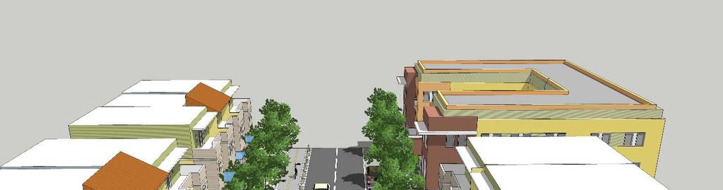
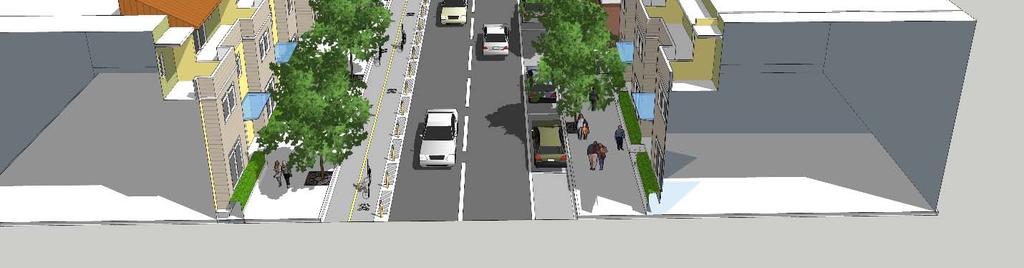
6 77 th Ave SE
, and a series of incentive features that will enable developments to")


7 REQUIREMENTS AND INCENTIVES The updated code will include both requirements for ALL development (regardless of building height), and a series of incentive features that will enable developments to achieve bonus building height in exchange for providing public amenities and other features. These incentive features can include both mandatory elements and items which must be provided but give the designer some flexibility. For example, we could structure the code so that in order to gain a 3 rd floor, a developer would be REQUIRED to step back the upper floors, provide additional public parking AND provide a specified level of affordability. In addition, they would have to do ONE of the following: meet a green building standard, contribute to public open space/plaza, OR create a publically accessible courtyard.
8 DOT EXERCISE The intent of this exercise is to get Stakeholder feedback on which elements should be mandatory for all development and which elements should be elective incentives. Some potential elements are listed, based on the current code and prior Stakeholder Group feedback. You can add more items on the blank sheet that follows. Please place RED dots next to the features that should be MANDATORY for all development, +1, +2 and +3 floors. Please place BLUE dots next to the features that should be ELECTIVES for all development, +1, +2 and +3 floors. Affordable housing Building setbacks from sidewalk Mid block pedestrian connections Public parking Stepped back upper floors Additional building articulation Green building features Underground parking Public art (sculptures, murals, etc) Landscaping, planting areas, etc Arcades, awnings, pergolas, etc Water features/fountains Benches/seating areas Public access to courtyards Contribution to major public plazas Mercerdale Park improvements Contribution to street improvements Improved traffic light timing systems Additional turn lanes Parking meters Civic amenity (branch library/reading room) +3 Floors +2 Floors +1 Floors All Development
9 +3 Floors +2 Floors +1 Floors All Development
Goal 1 - Retain and enhance Cherry Creek North s unique physical character.
 Introduction This document summarizes the proposed new zoning for the area of roughly bordered by University Boulevard, Steele Street, 3rd Avenue, and 1st Avenue. It provides a high-level review of the
Town Center Joint Commission Public Hearing #1: January 20, 2016
 Town Center Joint Commission Public Hearing #1: January 20, 2016 PROCESS PUBLIC HEARINGS Hearing 1 January 20 - Vision - Building height - Affordable Housing - Setbacks and massing Hearing 2 March 9 -
Draft Town Center Development and Design Guidelines w/placeholder graphics 11/21/15 Joint Commission Meeting
 CHAPTER 19.11 Sections 19.11.010 General 19.11.020 Town Center development-general. Land Uses 19.11.030 Nonconforming development Bulk Regulations 19.11.040 Building height. 19.11.050040 Significant ppublic
Approval of Takoma Amended Joint Development Agreement
 Planning, Program Development and Real Estate Committee Item IV- A October 10, 2013 Approval of Takoma Amended Joint Development Agreement Washington Metropolitan Area Transit Authority Board Action/Information
LITTLE MOUNTAIN ADJACENT AREA REZONING POLICY
 LITTLE MOUNTAIN ADJACENT AREA REZONING POLICY JANUARY 2013 CONTENTS 1.0 INTENT & PRINCIPLES...1 2.0 APPLICATION...2 3.0 HOUSING TYPES, HEIGHT & DENSITY POLICIES...3 3.1 LOW TO MID-RISE APARTMENT POLICIES...4
Land Use and Zoning Changes for Land Development Code Update
 Land Use and Zoning Changes for Land Development Code Update T2 T3 T4 T-5 Zoning District Urban Mixed-Use High Intensity Land Use February 25 th, 2014 T5 T6 COMMISSION DIRECTION ORIGINAL SCOPE OF SERVICES
VERTICAL MIXED USE DEVELOPMENT (Urban Village)
") VERTICAL MIXED USE DEVELOPMENT (Urban Village) Overall Goal Statement Vertical Mixed Use (Urban Villages) have similar goals to Horizontal Mixed Use except densities are usually higher and projects frequently
VERTICAL MIXED USE DEVELOPMENT (Urban Village) Overall Goal Statement Vertical Mixed Use (Urban Villages) have similar goals to Horizontal Mixed Use except densities are usually higher and projects frequently
WELCOME! TO THE UNIVERSITY ENDOWMENT LANDS BLOCK F PUBLIC OPEN HOUSE
 WELCOME! TO THE UNIVERSITY ENDOWMENT LANDS BLOCK F PUBLIC OPEN HOUSE The UEL & Block F What is the UEL? Site Location The University Endowment Lands (UEL) is a separate jurisdiction from the City of Vancouver
UPDATE Board of Selectmen June 20, 2017
 MAPLE STREET I-1 AREA DRAFT ZONING BYLAW & DEVELOPMENT STANDARDS Town of Danvers, MA UPDATE Board of Selectmen June 20, 2017 The Danvers Team: Brovitz Community Planning & Design Dodson & Flinker Danvers
Chapter DOWNTOWN ZONING DISTRICTS
 Chapter 20.14 Sections: 20.14.010 Purpose of the Downtown Zoning Districts 20.14.020 Land Use Regulations for Downtown Zoning Districts 20.14.030 Development Standards for Downtown Zoning Districts 20.14.010
Poverty Rates by Census Tracts
 The following document is a presentation that was delivered to the Housing Conservation District Advisory Group (HCDAG). The materials contained in this presentation (including several updates) were prepared
DEPARTMENT OF COMMUNITY PLANNING, HOUSING AND DEVELOPMENT Planning Division
 DEPARTMENT OF COMMUNITY PLANNING, HOUSING AND DEVELOPMENT Planning Division #1 Courthouse Plaza, 2100 Clarendon Boulevard, Suite 700 Arlington, VA 22201 TEL 703.228.3525 FAX 703.228.3543 www.arlingtonva.us
Zoning Regulations of the Town of Redding Connecticut
 Zoning Regulations of the Town of Redding Connecticut Statutory zoning authority was adopted for the Town of Redding, and a Zoning Commission established as provided by law, at a Town Meeting held May
College Avenue. Sowers Street. Calder Way. Beaver Avenue
 K L M Illustrative Master Plan: Collegiate District Calder Way Beaver Avenue High Street ner 16 Sowers Street Stre et 17 Hetzel Street 18 Gar Heister Street 15 Collegiate District 183 4-C: East End Collegiate
Jasper 115 Street DC2 Urban Design Brief
 Jasper 115 Street DC2 Urban Design Brief Greenlong Construction Ltd. Stantec Consulting Ltd. 2017 Overview The proposed rezoning application supports the development of two mixed-use high-rise buildings
th Avenue NW Early Design Guidance Meeting - SDCI # EDG Meeting
 - Proposed New Residential Construction Project (SDCI #3024352) 1 SEATTLE DESIGN REVIEW Date of EDG Meeting Early Design Guidance Meeting 1 PROJECT SUMMARY The proposed project consists of 74 residential
BYLAW NO. 15/026 A BYLAW OF THE REGIONAL MUNICIPALITY OF WOOD BUFFALO TO AMEND THE LAND USE BYLAW NO. 99/059
 Attachment 2 BYLAW NO. 15/026 A BYLAW OF THE REGIONAL MUNICIPALITY OF WOOD BUFFALO TO AMEND THE LAND USE BYLAW NO. 99/059 WHEREAS Section 639 of the Municipal Government Act requires every municipality
Appendix1,Page1. Urban Design Guidelines. Back to Back and Stacked Townhouses. DRAFT September 2017
 Appendix1,Page1 Urban Design Guidelines DRAFT September 2017 Back to Back and Stacked Townhouses Appendix1,Page2 Table of Contents 1 Introduction 1 1.1 Purpose 1 1.2 Urban Design Objectives 1 1.3 Building
Public Review of the Slot Home Text Amendment
 Public Review of the Slot Home Text Amendment The proposed amendments to the Denver Zoning Code have been informed by the Slot Home Strategy Report. This document has been developed out of a robust process
The demolition required for the project came before the Landmark Preservation Commission (LPC) on November 3, 2016, where no action was taken.
 on November 3, 2016, where no action was taken.") D E S I G N R E V I E W C O M M I T T E E S t a f f R e p o r t 2072 ADDISON STREET PRELIMINARY DESIGN REVIEW For Committee Discussion/ Majority Recommendation JULY 20, 2017 Design Review #DRCP2016-0002
D E S I G N R E V I E W C O M M I T T E E S t a f f R e p o r t 2072 ADDISON STREET PRELIMINARY DESIGN REVIEW For Committee Discussion/ Majority Recommendation JULY 20, 2017 Design Review #DRCP2016-0002
CAN TRADITIONAL ZONING ACHIEVE OUR GOALS FOR DOWNTOWN ANN ARBOR?
 TRADITIONAL ZONING TRADITIONAL ZONING CAN TRADITIONAL ZONING ACHIEVE OUR GOALS FOR DOWNTOWN ANN ARBOR? A dense, mixed use core with flexible land uses A range of housing types and costs A walkable, pedestrian-oriented
DAVIDSON PLANNING ORDINANCE AMENDMENTS AFTER SEPTEMBER 2009 SECTION 9
 AMENDMENT ADOPTED 6/12/2012 Section 9.1.3.3.1 Wall Murals Entire Section Added: 9.1.3.3.1 Wall Murals DAVIDSON PLANNING ORDINANCE AMENDMENTS AFTER SEPTEMBER 2009 SECTION 9 Exterior wall murals are only
Better Housing by Design - Proposed Draft Summary
 Better Housing by Design - Proposed Draft Summary How can Portland s multi-dwelling zones be improved to meet the needs of current and future residents? Review the BHD Proposed Draft for potential solutions,
DRAFT Plan Incentives. Part A: Basic Discount
 DRAFT 2030 Plan Incentives July 26, 2006 Part A: Basic Discount In order for a development to be eligible for any 2030 Land Resource Management Plan Discounts it must be located in the Urban Corridor and
City of Coral Gables Planning and Zoning Staff Report
 City of Coral Gables Planning and Zoning Staff Report Applicant: Application: Public Hearing: Date & Time: Location: City of Coral Gables Zoning Code Text Amendment Giralda Plaza Overlay District Planning
Missing Middle Housing in Practice
 Missing Middle Housing in Practice Daniel Parolek Principal, Opticos Design, Inc. dan@opticosdesign.com New Partners for Smart Growth Kansas City, MO 2013 1 Bungalow Courts Missing MIddle Housing 2012
WALNUT CREEK DESIGN REVIEW COMMISSION STAFF REPORT. AGENDA: July 6, 2016 ITEM 4b.
 WALNUT CREEK DESIGN REVIEW COMMISSION STAFF REPORT Attachment 3 AGENDA: July 6, 2016 ITEM 4b. ORIGINATED BY: COMMUNITY AND ECONOMIC DEVELOPMENT DEPARTMENT PLANNING PROJECT NAME APPLICATION TYPE APPLICATION
Bylaw No , being "Official Community Plan Bylaw, 2016" Schedule "A" DRAFT
 Bylaw No. 2600-2016, being "Official Community Plan Bylaw, 2016" Schedule "A" Urban Structure + Growth Plan Urban Structure Land use and growth management are among the most powerful policy tools at the
Back to Back and Stacked Townhouses
 Back to Back and Stacked Townhouses Draft Urban Design Guidelines & Proposed Zoning Regulations March 29, 2017 What have we done so far? September 19, 2016 Report to PDC summarizing positive and negative
REGULATING PLAN for the Plaza Saltillo TOD Station Area Plan (SAP)
") REGULATING PLAN for the Plaza Saltillo TOD Station Area Plan (SAP) Adopted: December 11, 2008 Effective: March 1, 2009 REGULATING PLAN for the Plaza Saltillo TOD Station Area Plan (SAP) CONTENTS BACKGROUND...iv
REGULATING PLAN for the Plaza Saltillo TOD Station Area Plan (SAP) Adopted: December 11, 2008 Effective: March 1, 2009 REGULATING PLAN for the Plaza Saltillo TOD Station Area Plan (SAP) CONTENTS BACKGROUND...iv
Approval of Takoma Amended Joint Development Agreement and Compact Public Hearing
 Planning, Program Development and Real Estate Committee Item IV - B March 13, 2014 Approval of Takoma Amended Joint Development Agreement and Compact Public Hearing Washington Metropolitan Area Transit
Crenshaw/LAX Transit Project Joint Development Fairview Heights Community Workshop #2 April 30, 2016
 Crenshaw/LAX Transit Project Joint Development Fairview Heights Community Workshop #2 April 30, 2016 1 Agenda 1. Introduction 2. What is Joint Development? 3. Community Input Process 4. What We ve Heard
PLANNING AND REGULATING HOUSING OPTIONS FOR CHANGING DEMOGRAPHICS
 PLANNING AND REGULATING HOUSING OPTIONS FOR CHANGING DEMOGRAPHICS New Partners for Smart Growth Conference February 2017 HOUSING MARKETS Significant increase in rental housing Offset robust single-family
UrbanFootprint Place Types. Urban Mixed Use. Urban Residential. Urban Commercial. Residential 1% SF Large Lot 0%
 Urban Mixed Use Residential 18% SF Large Lot 0% Employment 16% SF Small Lot 0% Mixed Use 45% Townhome 0% Open Space/Civic 21% MultiFamily 100% Intersections per mi 2 200 Office 80% Average Floors 23 Retail
Article 3. SUBURBAN (S-) NEIGHBORHOOD CONTEXT
 NEIGHBORHOOD CONTEXT") Article 3. SUBURBAN (S-) NEIGHBORHOOD CONTEXT this page left intentionally blank Contents ARTICLE 3. SUBURBAN (S-) NEIGHBORHOOD CONTEXT DIVISION 3.1 NEIGHBORHOOD CONTEXT DESCRIPTION...3.1-1 Section 3.1.1
Article 3. SUBURBAN (S-) NEIGHBORHOOD CONTEXT this page left intentionally blank Contents ARTICLE 3. SUBURBAN (S-) NEIGHBORHOOD CONTEXT DIVISION 3.1 NEIGHBORHOOD CONTEXT DESCRIPTION...3.1-1 Section 3.1.1
2.0 LAND USE FRAMEWORK
 Land Use Framework 2.0 LAND USE FRAMEWORK FOLSOM BOULEVARD 2.1 LAND USE OVERVIEW The proposed land uses for Easton Place offer local and regional employment, shopping, and entertainment, highlighting the
Chapter SPECIAL USE ZONING DISTRICTS
 Chapter 20.20 Sections: 20.20.010 Urban Transition (U-T) Zoning District 20.20.020 Planned Development (P-D) Zoning Districts 20.20.010 Urban Transition (U-T) Zoning District A. Purpose. The purpose of
Director, Community Planning, Etobicoke York District
 STAFF REPORT ACTION REQUIRED 3555 Don Mills Road Zoning By-law Amendment Application Preliminary Report Date: May 22, 2012 To: From: Wards: Reference Number: North York Community Council Director, Community
Evolution of the Vision for NE 181st Street Study Area
 City Council Action on NE 181 St Street Study Area Evolution of the Vision for NE 181st Street Study Area such uses to ensure neighborhood compatibility. More intense uses may be allowed through a conditional
PLANNING COMMISSION REPORT Regular Agenda -Public Hearing Item
 PDP-13-00518 Item No. 3B- 1 PLANNING COMMISSION REPORT Regular Agenda -Public Hearing Item PC Staff Report 2/24/14 ITEM NO. 3B PRELIMINARY DEVELOPMENT PLAN FOR HERE @ KANSAS; 1101 INDIANA ST (SLD) PDP-13-00518:
COMMERCIAL AND MIXED USE zones COMMERCIAL AND MIXED USE ZONES. Zoning By-law PLANNING & ECONOMIC DEVELOPMENT PLANNING DEPARTMENT DIVISION
 Zoning By-law 05-200 COMMERCIAL AND MIXED USE zones PLANNING & ECONOMIC DEVELOPMENT PLANNING DEPARTMENT DIVISION CONTENTS CONTEXT... 1 URBAN HAMILTON OFFICIAL PLAN... 2 COMMERCIAL AND MIXED USE ZONES...
GATEWAY DISTRICTS DRAFT ZONING & DEVELOPMENT STANDARDS City of Portsmouth, NH
 GATEWAY DISTRICTS DRAFT ZONING & DEVELOPMENT STANDARDS City of Portsmouth, NH PLANNING BOARD WORKSHOP June 22, 2017 Brovitz Community Planning & Design HOUSING INITIATIVES Portsmouth 2025 Master Plan (2017)
Composition of traditional residential corridors.
 Page 1 of 7 St. Petersburg, Florida, Code of Ordinances >> PART II - ST. PETERSBURG CITY CODE >> Chapter 16 - LAND DEVELOPMENT REGULATIONS >> SECTION 16.20.060. CORRIDOR RESIDENTIAL TRADITIONAL DISTRICTS
DEVELOPMENT STANDARDS FOR RESIDENTIAL PROJECTS RESIDENTIAL BUILDING TYPES: APPROPRIATE ZONES AND DENSITIES 2-1
 2 DEVELOPMENT STANDARDS FOR RESIDENTIAL PROJECTS RESIDENTIAL BUILDING TYPES: APPROPRIATE ZONES AND DENSITIES 2-1 This Chapter presents the development standards for residential projects. Section 2.1 discusses
17-23 Clairtrell Road and 391 Spring Garden Avenue - OPA & Rezoning, Site Plan - Preliminary Report
 STAFF REPORT ACTION REQUIRED 17-23 Clairtrell Road and 391 Spring Garden Avenue - OPA & Rezoning, Site Plan - Preliminary Report Date: April 10, 2008 To: From: Wards: Reference Number: North York Community
8.5.1 R1, Single Detached Residential District
 8.5.1 R1, Single Detached Residential District The purpose of this district is to provide for residential development in the form of single detached dwellings. Dwelling, Single Detached Home Business,
320 Maple Mixed Use PDR Narrative Fort Collins, CO Project # 1525
 320 Maple Mixed Use PDR Narrative Fort Collins, CO Project # 1525 July 28, 2015 (a) What are you proposing/use? A 47,00 S.F., 3-story, mixed used project with 30 for-sale condo residential units and 2
27-37 Yorkville Avenue and 26-32, 50 Cumberland Street Official Plan and Zoning Amendment - Final Report
 STAFF REPORT ACTION REQUIRED 27-37 Yorkville Avenue and 26-32, 50 Cumberland Street Official Plan and Zoning Amendment - Final Report Date: July 24, 2014 To: From: Wards: Reference Number: Toronto and
Ann Arbor Downtown Zoning Evaluation
 Ann Arbor Downtown Zoning Evaluation Options Workbook ENP & Associates in cooperation with the City of Ann Arbor September, 2013 Photo Courtesy of Andrew Horne, February 9, 2013 Introduction Thank you
EXHIBIT 1 PROJECT DESCRIPTION AND DESCRIPTION OF REQUESTED AREA VARIANCES REDEVELOPMENT OF 201 ELLICOTT STREET
 EXHIBIT 1 PROJECT DESCRIPTION AND DESCRIPTION OF REQUESTED AREA VARIANCES REDEVELOPMENT OF 201 ELLICOTT STREET I. PROJECT DESCRIPTION: Ciminelli Real Estate Corporation (the Applicant ) is seeking area
The Corporation of the District of Central Saanich
 The Corporation of the District of Central Saanich COMMITTEE OF THE WHOLE REPORT For the Committee of the Whole meeting on November 28, 2016 To: Patrick Robins Chief Administrative Officer File: From:
4 DEVELOPMENT STANDARDS FOR
 4 DEVELOPMENT STANDARDS FOR RESIDENTIAL MIXED-USE PROJECTS This chapter presents standards for residential mixed-use projects in the Ashland-Cherryland Business District and the Castro Valley Central Business
COMPLETE NEIGHBORHOODS AND HOUSING. Community Summit 02 February, 2012
 Lake Oswego Comprehensive Plan COMPLETE NEIGHBORHOODS AND HOUSING Community Summit 02 February, 2012 vision statement We have a wide variety of neighborhoods with high quality, attractive and compatible
Central Business District Core Ordinance
 Central Business District Core Ordinance July 2, 2013 Urban Districts Map, Pembroke SGA CBC District Map (tentative) BACKGROUND 11/09 - Pembroke SGA Plan adopted. Goal: Encourage urban-style development
5.1 Site Planning & Building Form
 5 Built Form 5.1 Site Planning & Building Form Pearson Dogwood Policy Statement Site Planning & Building Form The redevelopment of Pearson Dogwood will create an attractive and sustainable urban community
LeBreton Flats Redevelopment Development Summary Chart (First Subdivision)
") Redevelopment Development Summary Chart (First Subdivision) Development Analysis Chart NOTE: THE FOLLOWING TABLE REPRESENTS THE RESULTS OF THE NCC'S DEMONSTRATION OF DEVELOPMENT CAPACITY. WHILE ACTUAL
Redevelopment Development Summary Chart (First Subdivision) Development Analysis Chart NOTE: THE FOLLOWING TABLE REPRESENTS THE RESULTS OF THE NCC'S DEMONSTRATION OF DEVELOPMENT CAPACITY. WHILE ACTUAL
3.1. OBJECTIVES FOR RESIDENTIAL LAND USE DESIGNATIONS GENERAL OBJECTIVES FOR ALL RESIDENTIAL DESIGNATIONS
 3. RESIDENTIAL LAND USE DESIGNATIONS INTRODUCTION The Residential land use designations provide for housing and other land uses that are integral to, and supportive of, a residential environment. Housing
AGENDA SLOT HOME EVALUATION & TEXT AMENDMENT. 5:30 - Welcome
 AGENDA 5:30 - Welcome Please sign-in, put a sticker on the map, grab snacks, materials and a seat 5:45 - Staff Presentation 6:15 - Open House Stations Background Information Mixed Use Districts Multi Unit
Smart Growth in Mercer Island s Town Center
 Smart Growth in Mercer Island s Town Center Mercer Island Town Center History Just over five miles long and two miles wide, Mercer Island is an island community located in Lake Washington between the cities
density framework ILLUSTRATION 3: DENSITY (4:1 FSR) EXPRESSED THROUGH BUILT FORM Example 1
 EXPRESSED THROUGH BUILT FORM Example 1") density framework 4 ILLUSTRATION 3: DENSITY (4:1 FSR) EXPRESSED THROUGH BUILT FORM INTRODUCTION The Downtown Core Area contains a broad range of building forms within its relatively compact area. These
density framework 4 ILLUSTRATION 3: DENSITY (4:1 FSR) EXPRESSED THROUGH BUILT FORM INTRODUCTION The Downtown Core Area contains a broad range of building forms within its relatively compact area. These
Ann Arbor Downtown Premium Prioritization
 Ann Arbor Downtown Premium Prioritization What? The Ann Arbor Planning Commission is asking the public to share ideas in April 2015 on how downtown premiums, incentives of additional building area, might
1615 EDGEWATER DRIVE, SUITE 180 ORLANDO, FL T: /F: Memorandum
 1615 EDGEWATER DRIVE, SUITE 180 ORLANDO, FL 32804 T: 407-975-1273/F: 407-975-1278 Memorandum To: Erik Bredfeldt, Planning and Development Services Department Director CC: Scott Wright; Ralph Hilliard;
FISHERMANS BEND SUBMISSION NO. 136 PLANNING REVIEW PANEL 14 & 16 SALMON STREET, PORT MELBOURNE
 SUBMISSION NO. 136 FISHERMANS BEND PLANNING REVIEW PANEL 14 & 16 SALMON STREET, PORT MELBOURNE PRESENTED BY: ANDREA PAGLIARO ON BEHALF OF BELLAMIA NOMINEES PTY LTD & PCLC INVESTMENT PTY LTD INTRODUCTION
Architect: Lucio Trabucco Nunes Trabucco Architects 109 Highland Avenue Needham, MA Tel: Fax:
 Boston Planning & Development Agency Article 80 Small Project Review Submittal for Proposed Residential Building 50 Stedman Street Jamaica Plain, Massachusetts Architect: Lucio Trabucco Nunes Trabucco
PLANNING COMMISSION. Study Session: Beach Boulevard Specific Plan Workshop
 PLANNING COMMISSION Study Session: Beach Boulevard Specific Plan Workshop Project Background Sustainable Communities Grant Funding Phase 1 Outreach: Improve the Boulevard A Specific Plan is a long-term
COUNTY OF ALBEMARLE PLANNING STAFF REPORT SUMMARY
 COUNTY OF ALBEMARLE PLANNING STAFF REPORT SUMMARY Project Name: ZMA 2010-00015, Cedar Hill Planning Commission Worksession: February 15, 2011 Public Hearing: Not scheduled Staff: Judith C. Wiegand, AICP
Charlottesville Planning Commission, Neighborhood Associations & News Media
 CITY OF CHARLOTTESVILLE A World Class City Department of Neighborhood Development Services City Hall Post Office Box 911 Charlottesville, Virginia 22902 Telephone 434-970-3182 Fax 434-970-3359 www.charlottesville.org
CITY OF FATE, TEXAS UNIFIED DEVELOPMENT ORDINANCE. Article III Zoning Districts
 CITY OF FATE, TEXAS UNIFIED DEVELOPMENT ORDINANCE Article III Zoning Districts 3.1. General to all Zoning Districts and Zoning Map 3.1.1. Zoning Districts Established This article establishes the zoning
Chapter URBAN VILLAGE ZONING DISTRICTS
 Chapter 20.16 Sections: 20.16.010 Purpose of the Urban Village Zoning Districts 20.16.020 Land Use Regulations for the Urban Village Zoning Districts 20.16.030 Development Standards & Guidelines for the
Appendix A: Guide to Zoning Categories Prince George's County, Maryland
 Appendix A: Guide to Zoning Categories Prince George's County, Maryland RESIDENTIAL ZONES 1 Updated November 2010 R-O-S: Reserved Open Space - Provides for permanent maintenance of certain areas of land
Montreal Road District Secondary Plan [Amendment #127, October 9, 2013]
![Montreal Road District Secondary Plan [Amendment #127, October 9, 2013]](/thumbs/72/66783104.jpg "Montreal Road District Secondary Plan [Amendment #127, October 9, 2013]") [Amendment #127, October 9, 2013] 1.0 General The following policies are applicable to the Montreal Road District as set out in Schedule 1. 1.1 District Objectives The objective of this Plan is to guide
[Amendment #127, October 9, 2013] 1.0 General The following policies are applicable to the Montreal Road District as set out in Schedule 1. 1.1 District Objectives The objective of this Plan is to guide
APPENDIX A PART 1: GENERAL PLAN AMENDMENTS
 APPENDIX A PART 1: GENERAL PLAN AMENDMENTS I. CHANGES TO MAPS Amend the following figures to include the Plan Area boundaries: Chapter 4, Figure 15. Specific Plan Boundaries Chapter 4, Figure 16. Core
Official Plan & Zoning By-law Amendment Application Preliminary Report
 STAFF REPORT ACTION REQUIRED 847 873 Sheppard Avenue West Official Plan & Zoning By-law Amendment Application Preliminary Report Date: January 13, 2010 To: From: Wards: Reference Number: North York Community
DRAFT FOR DISCUSSION PURPOSES ONLY. Port Credit Local Area Plan Built Form Guidelines and Standards DRAFT For Discussion Purposes
 Port Credit Local Area Plan Built Form Guidelines and Standards DRAFT For Discussion Purposes 1 Local Area Plan - Project Alignment Overview Directions Report, October 2008 (General Summary Of Selected
TRANSIT-ORIENTED DEVELOPMENT PLAN EXISTING CONDITIONS REPORT LAWRENCE TO BRYN MAWR MODERNIZATION
 TRANSIT-ORIENTED DEVELOPMENT PLAN EXISTING CONDITIONS REPORT LAWRENCE TO BRYN MAWR MODERNIZATION March 2018- FINAL DRAFT SITE SPECIFIC DEVELOPMENT CONCEPTS SITE SPECIFIC DEVELOPMENT CONCEPTS This report
Poughkeepsie City Center Revitalization Plan
 Purpose and Need Purpose Increase job and educational opportunities for all residents Maximize fiscal productivity of downtown land uses Diversify retail mix Eliminate surface and building vacancies Create
Peter Street and 357 Richmond Street West - Zoning Amendment Application - Preliminary Report
 STAFF REPORT ACTION REQUIRED 122-128 Peter Street and 357 Richmond Street West - Zoning Amendment Application - Preliminary Report Date: March 11, 2016 To: From: Wards: Reference Number: Toronto and East
Urban Design Brief Dundas Street. London Affordable Housing Foundation. November Zelinka Priamo Ltd.
 Urban Design Brief 1039-1047 Dundas Street London Affordable Housing Foundation November 2017 Zelinka Priamo Ltd. TABLE OF CONTENTS Page No. INTRODUCTION... 3 SECTION 1 LAND USE PLANNING CONTEXT... 3 1.1
Article Optional Method Requirements
 Article 59-6. Optional Method Requirements [DIV. 6.1. MPDU DEVELOPMENT IN RURAL RESIDENTIAL AND RESIDENTIAL ZONES Sec. 6.1.1. General Requirements... 6 2 Sec. 6.1.2. General Site and Building Type Mix...
PUBLIC HEARINGS. Variance 1916, 1918 and 1920 St. Mary s Road (St. Norbert Ward) File DAV /2013D [c/r DASZ 28/2013]
![PUBLIC HEARINGS. Variance 1916, 1918 and 1920 St. Mary s Road (St. Norbert Ward) File DAV /2013D [c/r DASZ 28/2013]](/thumbs/90/101595906.jpg "PUBLIC HEARINGS. Variance 1916, 1918 and 1920 St. Mary s Road (St. Norbert Ward) File DAV /2013D [c/r DASZ 28/2013]") Agenda Riel Community Committee January 13, 2014 PUBLIC HEARINGS Item No. 3 Variance 1916, 1918 and 1920 St. Mary s Road (St. Norbert Ward) File DAV 163360/2013D [c/r DASZ 28/2013] WINNIPEG PUBLIC SERVICE
Agenda Riel Community Committee January 13, 2014 PUBLIC HEARINGS Item No. 3 Variance 1916, 1918 and 1920 St. Mary s Road (St. Norbert Ward) File DAV 163360/2013D [c/r DASZ 28/2013] WINNIPEG PUBLIC SERVICE
Downtown Development Focus Area: I. Existing Conditions
 Downtown Development Focus Area: I. Existing Conditions The Downtown Development Focus Area is situated along Route 1, south of the train tracks, except for the existing Unilever property. It extends west
10.2 ALBION AREA PLAN
 10.2 ALBION AREA PLAN Maple Ridge Official Community Plan Bylaw No. 7060-2014 Chapter 10, Page 5 10.2 ALBION AREA PLAN The following policies are adopted to guide development within the Albion urban area.
Primary Districts Established 4
 4.1 GENERAL PURPOSE SECTION 4 PRIMARY DISTRICTS ESTABLISHED The Town of Waxhaw, North Carolina is hereby divided into PRIMARY ZONING DISTRICTS as designated herein and as shown on the Official Zoning Map.
City of North Richland Hills Transit Oriented Development Code
 Section 118-561. Purpose and Intent: City of North Richland Hills Transit Oriented Development Code The purpose of the Transit Oriented Development (TOD) Code is to support the development of the community
Inwood NYC Update. CB 12 Land Use Committee May 3, 2017
 Inwood NYC Update CB 12 Land Use Committee May 3, 2017 Overview 1. Inwood NYC Recap 2. Community Engagement 3. Early City Investments - Investing in the people of Inwood - Improving neighborhood infrastructure
PLANNING COMMISSION STAFF REPORT
 PLANNING COMMISSION STAFF REPORT REZONING CASE: RZ-16-001 REPORT DATE: March 8, 2016 CASE NAME: Trailbreak Partners Rezoning PLANNING COMMISSION DATE: March 16, 2016 ADDRESSES OF REZONING PROPOSAL: 5501
Waterfront Project Summary ATTACHMENT 3
 Waterfront Project Summary ATTACHMENT 3 Central North & Central ATTACHMENT 3 South Waterfront Areas View from the front of the Ferry Building, looking up Georgia Street of the proposed development of Parcel
1 Valhalla Inn Road - Zoning Amendment - Preliminary Report
 STAFF REPORT ACTION REQUIRED 1 Valhalla Inn Road - Zoning Amendment - Preliminary Report Date: March 9, 2007 To: From: Wards: Reference Number: Etobicoke York Community Council Director, Community Planning,
770 BROOKFIELD ROAD Site Plan Control Atlantis Investments November 2017
 770 BROOKFIELD ROAD Site Plan Control Atlantis Investments November 2017 Prepared for: Atlantis Investments Inc. Prepared by: Fotenn Planning + Design 223 McLeod Street Ottawa, ON K2P 0Z8 fotenn.com October
4 LAND USE 4.1 OBJECTIVES
 4 LAND USE The Land Use Element of the Specific Plan establishes objectives, policies, and standards for the distribution, location and extent of land uses to be permitted in the Central Larkspur Specific
Community Advisory Committee (CAC) Meeting #7 West Anaheim Youth Center May 26, 2016
 Meeting #7 West Anaheim Youth Center May 26, 2016") Community Advisory Committee (CAC) Meeting #7 West Anaheim Youth Center May 26, 2016 1 Project Team City: David Belmer Planning and Building Director Jonathan Borrego, AICP Planning Services Manager Gustavo
Community Advisory Committee (CAC) Meeting #7 West Anaheim Youth Center May 26, 2016 1 Project Team City: David Belmer Planning and Building Director Jonathan Borrego, AICP Planning Services Manager Gustavo
The Town of Parker, Colorado
 August 14th, 2017 Development Design Standards commercial, industrial, and mixed-use The Town of Parker, Colorado 2017 URBAN DESIGN ASSOCIATES Where we are in the process: Tasks 1 & 2: Listening and Understanding
DRAFT STANDARDS PUBLIC DRAFT
 ?{ ROKEN ARROW Where opportunity lives DRAFT STANDARDS PULI DRAFT MAY 5, 2017 \ I AKNOWLEDGEMENTS TO E PROVIDED PREPARED Y: ADG OKLAHOMA ITY, OK WINTER AND OMPANY OULDER, O TALE OF ONTENTS I. INTRODUTION......................
38 th & Blake Height Amendments: Public Meeting #5 Building Design Comments July 13 th, 2016
 38 th & Blake Height Amendments: Public Meeting #5 Building Design Comments July 13 th, 2016 Table 1 1. Require people-oriented ground floors 2. Preserve sunlight, views, and architectural variety 3. Treat
MONROE WARD REZONING SUMMARY. October 2018
 MONROE WARD REZONING SUMMARY October 2018 WHY IS THE CITY REZONING MONROE WARD? In July of 2017 Richmond City Council adopted The Pulse Corridor Plan, a corridor-long planning document that outlines steps
PLANNED UNIT DEVELOPMENT & SUBDIVISION STAFF REPORT Date: April 18, 2019
 PLANNED UNIT DEVELOPMENT & SUBDIVISION STAFF REPORT Date: April 18, 2019 DEVELOPMENT NAME SUBDIVISION NAME Springhill Village Subdivision Springhill Village Subdivision LOCATION 4350, 4354, 4356, 4358,
PARRAMORE OAKS FRAMEWORK PLANNED DEVELOPMENT
 PARRAMORE OAKS FRAMEWORK PLANNED DEVELOPMENT Presented by Mark Cechman, AICP Paul S. Lewis, FAICP Review Process Pre- Application meeting August 11, 2016 Attended by representatives of: City Planning Transportation
TOD: Types of Capital Investment
 TOD Finance and M&E TOD: Types of Capital Investment When considering financing strategies for TOD corridor development, what needs to be financed? Transit Infrastructure Street Infrastructure & Public
LAKE MERRITT STATION AREA PLAN
 LAKE MERRITT STATION AREA PLAN Emerging Plan Open House Summary October 2011 2 1 Introduction The City of Oakland, Bay Area Rapid Transit (BART), and the Peralta Community College District, through a grant
Using Analysis to Improve the Environment for Transit
 Using Analysis to Improve the Environment for Transit POWERFUL ANALYTIC TOOLS Envision Tomorrow/ process Step 1: Scenario development starts by creating a library of building types that are financially