ELIMINATING THE FLOOD HAZARD Flood Plain Regulations in Medina County 2006
|
|
|
- Charles Maxwell
- 6 years ago
- Views:
Transcription
1 ELIMINATING THE FLOOD HAZARD Flood Plain Regulations in Medina County 2006 Steve Hambley, Medina County Commissioner Dan Willhoite, Medina County Highway Engineers Office & Floodplain Mgr. Choices in 2004 Status Quo Regulatory & Planning Solutions Market Solutions 1
2 Describing the Problem Describing the Problem 2
3 Describing the Problem Describing the Problem 3
4 Describing the Problem All Hazard and Flood Mitigation Planning Mitigation Planning in Medina County began with the formation of a committee (December 21, 2000) to become a Project Impact County. FEMA accepted and a formal signing ceremony was held on May 21, All Hazard and Flood Mitigation Plan Key purposes: Identify the possible risks and hazards that may affect Medina County through a systematic hazard identification and risk assessment process; Determine areas within Medina County that are vulnerable to various types of hazards; Strategize about the best approaches to avoid and mitigate impacts; Prioritize loss reduction and emergency preparedness activities; Included other important studies - Natural Resources Inventory (2002) and Chippewa Lake Watershed Study (2002) Adopted by local jurisdictions October March
 Were we moving fast enough?")


5 Chippewa Lake Watershed Study (Sept. 2002) Were we moving fast enough? Gloria Glens Flooding, July 2003 July of 2003, slow moving thunderstorms dropped up to four inches of rain on Medina County. Flash flooding occurred in portions of the county during the evening hours inches of rain fell in Chippewa Lake and around 3.5 inches in the City of Medina. Over two inches of rain was measured between 6 and 7 pm. 5
6 July 2003 Medina Area Storm In Montville Township, the west branch of the Rocky River left its bank and flooded several homes along River Styx Road. The river rose nine feet above normal causing a basement wall in one of the houses to collapse. Extensive lowland and street flooding occurred in the City of Medina with several roads damaged by the floodwaters. Many homes were damaged by flooding in the city. A total of 37 homes and 110 apartment units sustained major flood damage in the county. An additional 73 homes and 2 apartments sustained minor damage. Many businesses were also affected. At least seven motorists were rescued from stranded cars during the storm. Status Quo in 2004 Subdivision and Development Trend Increasing frequency of encroachment into flood prone and marginal lands by proposed residential subdivisions. Medina County Subdivision Regulations (2004). Section 605 C.2. states that [w]here subdivisions are proposed to be located in areas of periodic flooding or in identified 100 year flood hazard areas, such flood prone areas should be left undeveloped as much as possible and reserved as private or public open space, recreation areas, etc. No area where natural elevation is shown as flood prone and for a distance of 20 feet beyond that area shall be used for building sites. 6


7 River Trace Subdivision, Medina Twp Valley Estates, Liverpool Twp Schalmo Subdivision, Wadsworth Twp Rider Subdivision, Medina Twp 7


8 Chippewa Lake View FEMA Floodplain Residential Subdivision adjoining Chippewa Lake Project Ended by Eminent Domain Action of Medina County Park District Rivendale Subdivision, Medina Twp 40% of site in FEMA Floodplain Most of Roadway impacted Clustered units, but 36 of the proposed 130 units impacted Plan opposed by Township County Planning Commission Emergency Management County Soil & Water District 8

9 STAND-OFF RESOLVED 50 Sublots Property to be subdivided with possible intermittent recreational use in floodplain Status Quo Cost of Ignoring Problem Flash Flooding 2003 Montville Township: $2.2 million for 11 houses 75% Federal with $540,000 local match. Township Trustees appealed to County Commissioners for local match - Not funded. Township trustees are currently pursuing FEMA funding for purchase of 2 of the houses most prone to flooding using their own local match. Gloria Glens Chippewa Lake Medina County Emergency Management working with Gloria Glens Village & Medina County Commissioners A combination of local, Federal (FEMA) and State (Green Ohio) funds totaling $2.95 million will be used to purchase and demolish 37 homes subjected to historic flooding and presented to the village for community parkland. To date,10 of these homes have been purchased by the county and 6 dwellings demolished. 9
10 Regulatory and Planning Solutions County Flood Damage Prevention Regulations Licking County example Drainage Mitigation through HB 25 Building Code HB 25, ORC (a) - A county building code may include regulations that provide for a review of the specific effects of a proposed new construction on existing surface or subsurface drainage. The regulations may require reasonable drainage mitigation and reasonable alteration of a proposed new construction before a building permit is issued in order to prevent or correct any adverse effects that the proposed new construction may have on existing surface or subsurface drainage. Community Rating System under National Flood Insurance Program Savings to NFIP premium rates for County Residents Initial Step Resolution # County Commissioners created County Flood Damage Prevention Committee on July 26, 2004 Make recommendations to County Commissioners regarding: Update Flood Plain Regulations Flood Plain Management & Damage Prevention Program Participation in Community Rating System under National Flood Insurance Program Become a cooperating technical partner with FEMA for the update of county flood plain areas. Other suggested changes in public policies that would further the public purposes of the program 10
11 Medina County Flood Damage Prevention Committee Members (2004) Steve Hambley, Medina County Commissioner C.P. Buck Adams, Medina County Emergency Management Dan Willhoite, Medina County Highway Engineers Office & Floodplain Mgr. Mike Salay, Medina County Highway Engineer Tim Vanderlaan, Medina County Homebuilders Association Doug Loehr, Medina County Homebuilders Association Tom Longsdorf, Village Mayor's Association David Kopchak, USDA Chris Hartman, Medina County Soil and Water Conservation District Tom Russell, Medina County Dept. of Planning Services Kathleen Scheuztow, Township resident and trustee Representative from each city (3) and the Township association (1) Flood Damage Prevention Committee Subcommittees formed: Mapping Higher Standards (Floodplain Regulations) Community Rating System Start the paperwork for Premium Reductions Research system& process for insurance savings Land Use & Planning 11
12 Potential Market Oriented Solutions Other ideas discussed in 2004 Local Stormwater Utilities created by Subdivision HB 549 All Subdivision Properties assessed for stormwater retention benefit of natural floodplain Properties substantially located in 100 year floodplain purchased by Local Stormwater Assessment Fund Permanent Benchmark on All Structures Located in 100 year Floodplains Medina County Building Code BUILDING NEW FLOOD HAZARDS Thomas Jefferson once wrote, The whole of government consists in the art of being honest. So to properly address this issue, we have to be honest about it. The problem is real and it won t go away. Flooding isn t bad; it s a natural process that helps to maintain the health of a stream or river. Flooding is bad when people decide to place buildings in the way of the natural overflow of the watercourse. To be honest about it, our message to those wanting to build subdivisions and homes that create new flood hazards should be, No thanks. We don t need any more. 12
13 Beyond the NFIP: Higher Standards Chapter 3 of ODNR Publication: Ohio Floodplain Regulation Criteria (Nov. 2002) Higher Standards Subcommittee County Emergency Management Agency Director County Soil & Water Conservation District Manager County Home Builders Association Executive Director City of Brunswick Engineer City of Medina Councilman County Engineer (Floodplain Administrator) 13
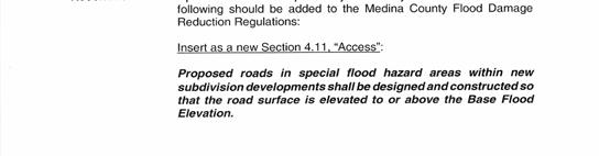
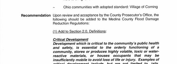
14 Higher Standards Considered Access Critical Development Materials Storage Compensatory Storage Floodway Rise Setbacks Use Restrictions Fill Higher Standards Selected Access Critical Development Materials Storage Compensatory Storage 14
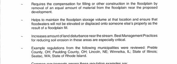
15 Higher Standards Researched Ohio Floodplain Regulation Criteria (ODNR) Regulations from other communities in Ohio (Appendix C, Compendium of Higher Standards ) Regulations from other communities across the U.S. (Internet Search) No Adverse Impact: A Toolkit for Common Sense Floodplain Management (ASFPM, 2003) Association of State Floodplain Managers Higher Standards Proposed Fact Sheets were created to describe: Purpose Considerations Pro s and Con s, Other Communities w/ Standard Recommendation Including Draft Language 15
16 16
17 17
18 Higher Standard Proposals Discussed and agreed upon by Higher Standards Subcommittee Presented to and accepted by Flood Damage Prevention Committee Draft revisions/additions to County s Flood Damage Reduction Regulations were submitted to: County Prosecutor s Office ODNR Floodplain Management Final adjustments to wording Resubmittal to ODNR Public Hearings for Commissioners adoption of revised regulations 18
Planning Commission Preliminary Plan Hidden Lakes Estates Medina Township EXECUTIVE SUMMARY
 Planning Commission Preliminary Plan Hidden Lakes Estates Medina Township Meeting: January 2, 2019 App. No.: 105-2018-PP Applicant: Hidden Lake Medina, LLC Engineer: Cunningham & Associates, LLC Parcel
Planning Commission Preliminary Plan Riverview Villas of Stonegate Medina Township App. No PP EXECUTIVE SUMMARY
 Planning Commission Preliminary Plan Riverview Villas of Stonegate Medina Township App. No. 088-2013-PP Meeting: January 8, 2014 Applicant: Stonegate Center, LLC Ken Cleveland Engineer: Lewis Land Professionals,
Planning Commission Preliminary Plan LRC Subdivision Montville Township
 Planning Commission Preliminary Plan LRC Subdivision Montville Township Meeting: February 1, 2017 App. No.: 002-2017-PP Owner: Faith & Hope Land Dev. Co. Applicant: Montville Investors LLC Engineer: Weber
Planning Commission Final Plat Liverpool Fields, Phase 3 Liverpool Township App. No PP EXECUTIVE SUMMARY
 Planning Commission Final Plat Liverpool Fields, Phase 3 Liverpool Township App. No. 59-21-PP Meeting: August 6, 21 Applicant: Pride One Liverpool, LLC Owner: Pride One Liverpool, LLC Engineer: TGC Engineering
EXECUTIVE SUMMARY. Access: Access to the site is by the proposed extension of Stockbridge Drive.
 Variance & Final Plat Preserve at Trillium Creek, Ph. 1 Montville Township Meeting: January 2, 2019 App. No.: 096-2018-FP Applicant: Haslinger Holdings Owners: Trillium Creek LLC Engineer: Lewis Land Prof.
Meeting Minutes Lodi Township Planning Commission November 27, 2012 Lodi Township Hall 3755 Pleasant Lake Road Ann Arbor, MI 48103
 Meeting Minutes Lodi Township Planning Commission November 27, 2012 Lodi Township Hall 3755 Pleasant Lake Road Ann Arbor, MI 48103 1) Call to Order The meeting was called to order by Chair Jack Steeb at
Appendix A Reproducible Forms
 Appendix A Reproducible Forms Form LD-33 LD-34 LD-35 LD-40 LD-41 LD-42 LD-50 LD-51 LD-52 LD-53 Subject County Engineer Approval Form Storm Sewer Computation Sheet Ohio Drainage Design Criteria Form Gutter
Group Sewer Only** 80 Ft Frontage* 20,000 Sq. Ft. (.46 acre) Minimum** 120 Ft Frontage* 20,000 Sq. Ft. (.46acre) Minimum** 150 Ft Frontage*
 Minimum** 120 Ft Frontage* 20,000 Sq. Ft. (.46acre) Minimum** 150 Ft Frontage*") Residential Lots Minimum Chart The minimum lot size of any minor subdivision where there is no public sewers shall be as shown below or as required by township zoning and/or the Tuscarawas General Health
Residential Lots Minimum Chart The minimum lot size of any minor subdivision where there is no public sewers shall be as shown below or as required by township zoning and/or the Tuscarawas General Health
Surface Water Management District. Summit County Engineer Alan Brubaker, P.E., P.S.
 Surface Water Management District Summit County Engineer Alan Brubaker, P.E., P.S. Stormwater We have spent the last nine years devising various solutions to stormwater issues in Summit County With no
Final Plat Trails at Redwood Falls, Ph. 1 Hinckley Township EXECUTIVE SUMMARY
 Final Plat Trails at Redwood Falls, Ph. 1 Hinckley Township Meeting: December 5, 2018 App. No.: 069-2017-PP Owner: Skyland Land Company LLC Engineer: TGC Engineering, T. Crane Parcel Nos.: 016-03A-38-012,
Residential Minor Subdivision Review Checklist
 Residential Minor Subdivision Review Checklist Plan Submittal Requirements: 2 full sets of stamped plans Electric submittal - all plans contained in a single PDF 3 full sets if commercial kitchen or dining
REGULAR FINAL PLAT SUBDIVISION APPLICATION
 REGULAR FINAL PLAT SUBDIVISION APPLICATION Name of Subdivision (Subdivision Name must be approved by at 856-6216) ( )Cluster Subdivision ( )Lot-by-Lot Subdivision ( )Open Space Subdivision Name of Subdivision
Planning Commission Final Plat Riverview Villas of Stonegate Medina Township App. No FP EXECUTIVE SUMMARY
 Planning Commission Final Plat Riverview Villas of Stonegate Medina Township App. No. 077-2014-FP Meeting: October 1, 2014 Applicant: Stonegate Center, LLC Ken Cleveland Engineer: Lewis Land Professionals,
ARTICLE 5 MINOR SUBDIVISION/LAND DEVELOPMENT
 ARTICLE 5 MINOR SUBDIVISION/LAND DEVELOPMENT SECTION 501 ONLY FINAL PLAN REQUIRED The classification of a proposed subdivision as a "Minor Subdivision" shall only require the submission, review and approval
ESTES VALLEY STORMWATER MANAGEMENT PROGRAM
 ESTES VALLEY STORMWATER MANAGEMENT PROGRAM Phase I. Stormwater Master Plan Phase II. Stormwater Utility Feasibility Study Board of Realtors Meeting May 3, 2018 Stormwater Master Plan Summary Stormwater
NOTICE OF LAND USE DECISION BY THE COOS COUNTY PLANNING DIRECTOR
 NOTICE OF LAND USE DECISION BY THE COOS COUNTY PLANNING DIRECTOR Coos County Planning 225 N. Adams St. Coquille, OR 97423 http://www.co.coos.or.us/ Phone: 541-396-7770 Fax: 541-396-1022 This notice is
(Chapter Flood Damage Prevention)
") Chapter 13.10 Flood Damage Prevention Section: 13.10.010 Purpose and Policy 13.10.020 Definitions 13.10.030 Applicability and Areas of Special Flood Hazard 13.10.040 Administration 13.10.050 Provisions
Chapter 13.10 Flood Damage Prevention Section: 13.10.010 Purpose and Policy 13.10.020 Definitions 13.10.030 Applicability and Areas of Special Flood Hazard 13.10.040 Administration 13.10.050 Provisions
CHAPTER 24 F FLOOD ZONE OVERLAY DISTRICT
 CHAPTER 24 OVERLAY DISTRICT SECTION 24.01 PURPOSE It is the intent of this district to apply special regulation to the use of land in those areas subject to periodic inundation. Such regulation is deemed
FREQUENTLY USED PLANNING & ZONING TERMS
 City Of Mustang FREQUENTLY USED PLANNING & ZONING TERMS Abut: Having property lines, street lines, or zoning district lines in common. Accessory Structure: A structure of secondary importance or function
5: SUBDIVISION PLAN AND PLAT APPLICATION SUBMITTAL REQUIREMENTS
 5) SECTION 5: SUBDIVISION PLAN AND PLAT APPLICATION SUBMITTAL REQUIREMENTS A. Submittal. All applications and supplemental material shall be bound in sets ready for distribution. All copies of plats, other
CITY OF GROVER BEACH COMMUNITY DEVELOPMENT DEPARTMENT Tentative Map Checklist
 CITY OF GROVER BEACH COMMUNITY DEVELOPMENT DEPARTMENT Tentative Map Checklist The following list includes all of the items you must submit for a complete application. Some specific types of information
Guide to Preliminary Plans
 Guide to Preliminary Plans Introduction The Douglas County is committed to providing open, transparent application processes to the public. This Guide is provided to assist anyone interested in the procedures
Attached is a Clinton Township Zoning Permit Application and requirements for issuance of a permit.
 To Whom It May Concern: Attached is a Clinton Township Zoning Permit Application and requirements for issuance of a permit. The fee for the permit application is $75.00, which shall be made payable to
UPPER MOUNT BETHEL TOWNSHIP, NORTHAMPTON COUNTY, PA MINOR SUBDIVISION FINAL PLAN CHECKLIST* YES** NO
 UPPER MOUNT BETHEL TOWNSHIP, NORTHAMPTON COUNTY, PA MINOR SUBDIVISION FINAL PLAN CHECKLIST* YES** NO GENERAL SUBMISSION ITEMS Does the submission include: 1. Seven (7) copies of completed Application Form?
Residential Major Subdivision Review Checklist
 Residential Major Subdivision Review Checklist Plan Submittal Requirements: 2 full sets of stamped plans Electric submittal - all plans contained in a single PDF 3 full sets if commercial kitchen or dining
CHARTER TOWNSHIP OF FENTON BOARD OF TRUSTEES MINUTES FOR REGULAR MEETING OF AUGUST 3, 2009
 FENTON TOWNSHIP CIVIC COMMUNITY CENTER 12060 MANTAWAUKA DRIVE, FENTON, MICHIGAN Supervisor Mathis called the meeting to order at 7:30 p.m. Present: Mathis, Tucker, Brown, Goupil, Hill, Operations Manager
PRELIMINARY PLAT CHECK LIST
 PRELIMINARY PLAT CHECK LIST Name of Proposed Subdivision: The following items must be included with the initial submittal of a Preliminary Plat: Application, filled out completely Project Narrative Pre-application
FEMA POLICY: GUIDANCE ON THE USE OF AVAILABLE FLOOD HAZARD INFORMATION
 FEMA POLICY: GUIDANCE ON THE USE OF AVAILABLE FLOOD HAZARD INFORMATION FEMA Policy #104-008-2 BACKGROUND The policy is for FEMA Headquarters, Regional program staff, and for the Field Staff at the Joint
COMMERCIAL SITE DEVELOPMENT GUIDE FOR UNINCORPORATED ST. CHARLES COUNTY
 COMMERCIAL SITE DEVELOPMENT GUIDE FOR UNINCORPORATED ST. CHARLES COUNTY GENERAL INFORMATION: This brochure is to be used as a guide and is not intended to amend or supersede the corresponding County ordinances
Guide to Replats. Step 1. Step 2. Step 3. Step 4. Step 5. Step 6. Step 7. Step 8. Step 9. Step 10
 Guide to Replats Introduction Douglas County is committed to providing open, transparent application processes to the public. This Guide is provided to assist anyone interested in the procedures and expectations
Guide to Minor Developments
 Guide to Minor Developments Introduction The Douglas County (DCD) is committed to providing open, transparent application processes to the public. This Guide is provided to assist anyone interested in
Private Landowner Contribution for Erosion Control Works
 Private Landowner Contribution for Erosion Control Works Category Approved by Application to the General Public or Have Significant Implications Authority Approval date (last amendment) January 27 2017
MAGNOLIA SPRINGS SUBDIVISION, PHASE ONE
 MAGNOLIA SPRINGS SUBDIVISION, PHASE ONE Engineering Comments: Must comply with the Mobile County Flood Damage Prevention Ordinance. Development shall be designed to comply with the storm water detention
MULTI-FAMILY DWELLING UNIT SUBDIVISION ORDINANCE TOWN OF SIDNEY, MAINE
 MULTI-FAMILY DWELLING UNIT SUBDIVISION ORDINANCE TOWN OF SIDNEY, MAINE I. GENERAL A. Title B. Purpose C. Administration D. Scope II. DEFINITIONS A. Building Height B. Dwelling Unit C. Family D. Multi-Unit
SUBDIVISION APPLICATION CHECKLIST SKETCH PLAN PRELIMINARY PLAT FINAL PLAT
 RECEIVED STAMP SUBDIVISION APPLICATION CHECKLIST SKETCH PLAN PRELIMINARY PLAT FINAL PLAT A checklist of background information and submission requirements for processing of a sketch plan, preliminary plat
ARTICLE 18 TABLE OF CONTENTS TO THE FLOODPLAIN MANAGEMENT REGULATIONS
 Table of Contents Valley Center Floodplain Ordinance ARTICLE 18 TABLE OF CONTENTS TO THE FLOODPLAIN MANAGEMENT REGULATIONS Chapter 18.01 STATUTORY AUTHORIZATION, FINDINGS OF FACT & PURPOSES...1 18.01.01
Guide to Combined Preliminary and Final Plats
 Guide to Combined Preliminary and Final Plats Introduction The Douglas County is committed to providing open, transparent application processes to the public. This Guide is provided to assist anyone interested
Model Acknowledgement of Conditions For Mitigation of Property in a Special Flood Hazard Area With FEMA Grant Funds Property Owner Street Address City
 Model Acknowledgement of Conditions For Mitigation of Property in a Special Flood Hazard Area With FEMA Grant Funds Property Owner Street Address City State Zip Code Deed dated, Recorded Tax map, block,
Larimer County Planning Dept. Procedural Guide for 1041 PERMITS
 - Larimer County Planning Dept. Procedural Guide for 1041 PERMITS PLEASE NOTE: A PRE-APPLICATION CONFERENCE IS REQUIRED PRIOR TO SUBMITTING THIS APPLICATION. PURPOSE: State Statutes allow local governments
Solutions to the Rising Costs of Fighting Fires in the Wildland Urban Interface 10 Ideas
 Solutions to the Rising Costs of Fighting Fires in the Wildland Urban Interface 10 Ideas Wildland firefighting is dangerous, expensive, & costs are rising Costs the federal government more than $3 billion
Town of Alexandria. Floodplain Management Ordinance
 1 of 7 8/8/2009 4:56 PM Town of Alexandria Floodplain Management Ordinance SECTION 1 PURPOSE Certain areas of the Town of Alexandria, New Hampshire are subject to periodic flooding, causing serious damages
Plan and Zoning Commission Review Process
 . Village of Northfield Plan and Zoning Commission Review Process.......... Department of Community Development and Building Village of Northfield Department of Community Development and Building 361 Happ
TUSCARAWAS COUNTY FLOOD DAMAGE REDUCTION REGULATIONS
 TUSCARAWAS COUNTY FLOOD DAMAGE REDUCTION REGULATIONS 2010 Approved for adoption by ODNR 5/11/07 Adopted by the Board of Tuscarawas County Commissioners Date: October 1, 2007 Resolution No: 736-2007 Revised
*For Special Exception and Conditional Uses, Complete Page 3 of this application.
 PLEASE READ CAREFULLY All applications, plans fees and support documents must be submitted at least 21 days prior to the Planning Commission meeting. Applicants must submit 20 FOLDED copies of their plan.
Sign-in sheets are attached at the end of the minutes as Exhibit A.
 Sign-in sheets are attached at the end of the minutes as Exhibit A. It was noted that although the Commissioners are leading the meeting, because there are quorums of different public boards present at
LETTER OF APPLICATION
 Description of Proposed Land Division: LETTER OF APPLICATION The proposed land division would split a 1.94 acres rectangular lot into two lots. The general configuration would have one lot in front of
***** Subchapter A. GENERAL PROVISIONS ***** PERMIT APPLICATIONS
 105.11. Permit requirements. 105.12. Waiver of permit requirements. Title 25 Environmental Protection Part I. Department of Environmental Protection Subpart C. Protection of Natural Resources Article I.
Floodplain Development Land Use Review
 PUBLIC WORKS - COMMUNITY DEVELOPMENT 333 Broadalbin Street SW, PO Box 490, Albany, Oregon 97321-0144 BUILDING 541-917-7553 PLANNING 541-917-7550 Floodplain Development Land Use Review Application Information
Appendix A Orleans County Local Law Assessment
 Appendix A Orleans County Local Law Assessment Appendix A 0 Albion, Town Does the municipality have: Comprehensive/ Master Local Law Assessment es o Reference: Comments: Town of Albion, Village of Albion,
TOWN OF WATERVILLE VALLEY NEW HAMPSHIRE SITE PLAN REVIEW REGULATIONS
 TOWN OF WATERVILLE VALLEY NEW HAMPSHIRE Effective date March 17, 1981 Revised March 16, 1982 Revised March 13, 1986 Revised March 10, 1987 Revised March 14, 2013 Revised March 8, 2016 TOWN OF WATERVILLE
BY BOARD OF COUNTY COMMISSIONERS AN ACT TO BE ENTITLED
 BY BOARD OF COUNTY COMMISSIONERS ORDINANCE NO. AN ACT TO BE ENTITLED AN ORDINANCE AMENDING THE PASCO COUNTY LAND DEVELOPMENT CODE, ARTICLE 700, BY REPEALING EXISTING SECTION 702, ENVIRONMENTALLY SENSITIVE
Legal Description Part of the Western Half of the Eastern Half of the Northwest Quarter of Section 30, Le Ray Township
 Owner and Applicant s 20448 State Highway 83 Mankato, MN 56001 Request and Location Request for review and approval of a Conditional Use Permit to allow an Elder Care Residential Unit to be constructed
Chelan County Comprehensive Flood Hazard Management Plan County Commissioner Meeting #2
 Chelan County Comprehensive Flood Hazard Management Plan County Commissioner Meeting #2 December 16, 2016 Today's Speaker Rob Flaner Floodplain Management Plan Technical Lead, Tetra Tech, Inc. Technical
Date of Review: 11/6/2015 Reviewer: RCQ/LMC STATE
 FINAL Florida Review Checklist: NFIP & FBC & Revised Model Ordinance (January 15, 2013d) Ordinance Citation: Model FPM regulations and 5 th Edition FBC : All Zones Date of Review: 11/6/2015 Reviewer: RCQ/LMC
BRIDGETON SUBDIVISION APPLICATION CHECKLIST
 APPLICATION NAME AND # CHECKLIST COMPLETED BY: DATE: Signature and printed name BRIDGETON SUBDIVISION APPLICATION CHECKLIST TO SUBDIVISION APPLICANTS: The attached checklist is to assist you in the submission
RULES AND REGULATIONS FOR ADMINISTRATION OF AREA DRAINAGE PLANS
 RIVERSIDE COUNTY RULES AND REGULATIONS FOR ADMINISTRATION OF AREA DRAINAGE PLANS ADOPTED JUNE 10, 1980 BY RESOLUTION NO. 80-244 AMENDMENTS RESOLUTION NO. May 26, 1981 81-148 Nov. 9, 1982 82-320 July 3,
CHECKLIST FOR DEVELOPMENT REVIEW
 CHECKLIST FOR DEVELOPMENT REVIEW Petitions and related documents and plans for land development or other proposals regulated by Title 16 of the Municipal Code (Development Ordinance) and Title 17 of the
[Docket ID FEMA ; Internal Agency Docket No. FEMA-B-1808] AGENCY: Federal Emergency Management Agency, DHS.
![[Docket ID FEMA ; Internal Agency Docket No. FEMA-B-1808] AGENCY: Federal Emergency Management Agency, DHS.](/thumbs/82/86021413.jpg "[Docket ID FEMA ; Internal Agency Docket No. FEMA-B-1808] AGENCY: Federal Emergency Management Agency, DHS.") This document is scheduled to be published in the Federal Register on 03/16/2018 and available online at https://federalregister.gov/d/2018-05415, and on FDsys.gov 1 Billing Code 9110-12-P DEPARTMENT OF
This document is scheduled to be published in the Federal Register on 03/16/2018 and available online at https://federalregister.gov/d/2018-05415, and on FDsys.gov 1 Billing Code 9110-12-P DEPARTMENT OF
Floodplain Management: New York State Role
 Floodplain Management: New York State Role Establish development/building standards State building code Model local law for flood damage prevention Provide technical assistance to local communities/agencies
[Docket ID FEMA ; Internal Agency Docket No. FEMA-B-1518] AGENCY: Federal Emergency Management Agency, DHS.
![[Docket ID FEMA ; Internal Agency Docket No. FEMA-B-1518] AGENCY: Federal Emergency Management Agency, DHS.](/thumbs/87/97204602.jpg "[Docket ID FEMA ; Internal Agency Docket No. FEMA-B-1518] AGENCY: Federal Emergency Management Agency, DHS.") This document is scheduled to be published in the Federal Register on 06/08/ and available online at http://federalregister.gov/a/-13857, and on FDsys.gov 1 9110-12-P DEPARTMENT OF HOMELAND SECURITY Federal
This document is scheduled to be published in the Federal Register on 06/08/ and available online at http://federalregister.gov/a/-13857, and on FDsys.gov 1 9110-12-P DEPARTMENT OF HOMELAND SECURITY Federal
Land Use Application
 Land Use Application Check all permits you are applying for in the boxes provided. Submit this application form, the applicable materials listed in the corresponding permit application packet(s) and application
The Corporation of the Town of Orangeville
 The Corporation of the Town of Orangeville Form for Applications under the Planning Act Please tick one or more boxes to indicate the type of application(s) Office Use Only Official Plan Amendment Zoning
FAIRFIELD COUNTY SUBDIVISION REGULATIONS APRIL 1, 1989
 FAIRFIELD COUNTY SUBDIVISION REGULATIONS APRIL 1, 1989 REVISED JUNE 13, 2000 REVISED JANUARY 29, 2002 REVISED APRIL 16, 2002 REVISED JANUARY 1, 2003 REVISED JANUARY 28, 2003 REVISED MARCH 11, 2003 REVISED
CITRUS HEIGHTS COMMUNITY SPECIAL PLANNING AREA
 CITRUS HEIGHTS COMMUNITY SPECIAL PLANNING AREA 501-90. INTENT. It is the intent of the Board of Supervisors in adopting this Special Planning Area Ordinance to allow development on the property described
SPECIAL PURPOSE FLOOD DAMAGE PREVENTION REGULATIONS for FAIRFIELD COUNTY
 SPECIAL PURPOSE FLOOD DAMAGE PREVENTION REGULATIONS for FAIRFIELD COUNTY Adopted September 7, 1995 Effective October 9, 1995 Flood Maps are available in the Fairfield County Regional Planning Commission
Township of Little Egg Harbor Planning Board 665 Radio Road Little Egg Harbor, New Jersey Phone: ext. 221 Fax:
 BLOCK(S) LOT(S) Township of Little Egg Harbor Planning Board 665 Radio Road Little Egg Harbor, New Jersey 08087 Phone: 609-296-7241 ext. 221 Fax: 609-294-3040 Development Application Amended Development
To provide for the review of the final engineering plans, the subdivision improvement agreement, public dedications, and other legal agreements.
 ARTICLE 5 FINAL PLAT 501 Intent DOUGLAS COUNTY SUBDIVISION RESOLUTION To provide for the review of the final engineering plans, the subdivision improvement agreement, public dedications, and other legal
City of Leavenworth DEPARTMENT OF DEVELOPMENT SERVICES MAJOR SUBDIVISION APPLICATION 1
 Proposed Name of Subdivision: City of Leavenworth DEPARTMENT OF DEVELOPMENT SERVICES MAJOR SUBDIVISION APPLICATION 1 FOR PRELIMINARY SUBDIVISION APPROVAL This application must be filled out legibly, in
Frequently Asked Questions for: Drainage, Watershed and Water Quality Property Owners Near Creeks Developers and Engineers and Definitions of Terms
 FREQUENTLY ASKED QUESTIONS Draft DEFINITIONS OF TERMS Last Revised July 2, 2008 Introduction: The following questions have been organized in the categories below. We have attempted to group the questions
LINCOLN COUNTY FLOOD DAMAGE PREVENTION ORDINANCE
 LINCOLN COUNTY FLOOD DAMAGE PREVENTION ORDINANCE SECTION 1.0 STATUTORY AUTHORIZATION, FINDINGS OF FACT, PURPOSE AND OBJECTIVES SECTION 2 DEFINITIONS SECTION 3.0 GENERAL PROVISIONS SECTION 4.0 ADMINISTRATION
MINOR SUBDIVISION APPLICATION
 MINOR SUBDIVISION APPLICATION Complete with required information (write "n/a" if information is not applicable to proposal). Title of Plat Has any other plat been recorded for this site? ( ) Yes ( ) No
DOUGLAS COUNTY SUBDIVISION RESOLUTION Article 4 Preliminary Plan 10/13/2015
 ARTICLE 4 PRELIMINARY PLAN 401 Intent An in-depth analysis of the proposed subdivision, including a review of the design considering the ability to obtain water and sanitation, identified geologic hazards,
Tuscarawas County Board of Commissioners. Regional Planning Commission. Officers
 Tuscarawas County Board of Commissioners Chris Abbuhl Kerry Metzger Belle Everett Regional Planning Commission Jill P. Lengler, Director Gloria Steiner, Executive Secretary Executive Committee Officers
Residential Subdivision Preliminary Plat Application
 WATER MODELING FEES Major : $650 or Minor : $550 # of lots x $35 per lot Residential Preliminary Plat Application Lots: 1-9 10-19 20-49 50-99 100-199 $300 $400 $475 $625 $825 200-349 350-499 500-499 700-999
Section Floodplain Development Ordinance This ordinance, adopted pursuant to the authority of RSA 674:16, shall be known as the Town of Newport
 Section 212 - Floodplain Development Ordinance This ordinance, adopted pursuant to the authority of RSA 674:16, shall be known as the Town of Newport Floodplain Development Ordinance. The regulations and
SUBDIVISION STANDARDS AND REGULATIONS FOR GUERNSEY COUNTY, OHIO
 SUBDIVISION STANDARDS AND REGULATIONS FOR GUERNSEY COUNTY, OHIO 2006 SUBDIVISION REGULATIONS GUERNSEY COUNTY, OHIO ESTABLISHED BY: BOARD OF COUNTY COMMISSIONERS GUERNSEY COUNTY, OHIO FOR THE PURPOSE OF:
Chapter Plat Design (LMC)
") Chapter 18.14 Plat Design (LMC) Sections: 18.14.010 Lot width 18.14.020 Right-of-way requirements 18.14.030 Pipe stem lots 18.14.040 Division resulting in minimum lot sizes 18.14.050 Flood prone and bad
Chapter 18.14 Plat Design (LMC) Sections: 18.14.010 Lot width 18.14.020 Right-of-way requirements 18.14.030 Pipe stem lots 18.14.040 Division resulting in minimum lot sizes 18.14.050 Flood prone and bad
PRELMINARY PLAT CHECKLIST
 PRELMINARY PLAT CHECKLIST A. All preliminary plat submitted for approval shall be prepared by a Registered Professional Land Surveyor. B. Preliminary plats must be drawn to a scale of XXX with such accuracy
Planning Commission Replat Arbor Lakes at Cobblestone Park, Ph. 10 Montville Township
 Planning Commission Replat Arbor Lakes at Cobblestone Park, Ph. 10 Montville Township Meeting: May 4, 2016 App. No.: 037-2016-R Developer: Cobblestone Park Development Group, LLC Surveyor: TGC Engineering
I. Requirements for All Applications. C D W
 108-16.1. Application checklists. Checklist for Required Submissions to the Planning Board or Zoning Board of Adjustment of Monroe Township All required submissions are to be made to the Administrative
Memorandum: October 13, 2008 REVISED To: Trowbridge Township Planning Commission From: P. Hudson, AICP Re: Suggested New Ordinance
 1 Memorandum: October 13, 2008 REVISED 2-11-09 To: Trowbridge Township Planning Commission From: P. Hudson, AICP Re: Suggested New Ordinance Because of changes in both the Michigan Planning Enabling Act
Planning Commission Revised Preliminary Plan & Final Plat Maplebrooke Reserve Subdivision Montville Township EXECUTIVE SUMMARY
 Planning Commission Revised Preliminary Plan & Final Plat Maplebrooke Reserve Subdivision Montville Township Meeting: October 5, 2016 App. No.: 091-2016 RPP and 093-2016-FP Applicant: Cambridge Service
APPLICATION FOR APPROVAL OF A PLAN OF SUBDIVISION or CONDOMINIUM DESCRIPTION Under Section 51 of the Planning Act
 APPLICATION FOR APPROVAL OF A PLAN OF SUBDIVISION or CONDOMINIUM DESCRIPTION Under Section 51 of the Planning Act NOTE TO APPLICANTS: This application form is to be used if applying for approval of a proposed
Napa County Planning Commission Board Agenda Letter
 Agenda Date: 9/20/2017 Agenda Placement: 8C Napa County Planning Commission Board Agenda Letter TO: FROM: Napa County Planning Commission Charlene Gallina for David Morrison - Director Planning, Building
SPECIAL PURPOSE FLOOD DAMAGE REDUCTION RESOLUTION FOR PICKAWAY COUNTY, OHIO
 SPECIAL PURPOSE FLOOD DAMAGE REDUCTION RESOLUTION FOR PICKAWAY COUNTY, OHIO Effective December 7, 2012 Pickaway County Board of Commissioners Glenn D. Reeser Jay H. Wippel Ula Jean Metzler Terry L. Frazier,
SUBDIVISION REGULATIONS
 CHAPTER 14 SUBDIVISION REGULATIONS 14-100 Provisions 14-200 Preliminary Plat 14-300 Final Plat 14-400 Replat 14-500 Minor Subdivision 14-600 Administrative Replat 14-700 Vacation of Roadways, Public Easements,
Waseca County Planning and Zoning Office
 Waseca County Planning and Zoning Office 300 North State Street Waseca, Minnesota 56093 Phone: 507-835-0650 Fax: 507-837-5310 Form no. PZ 081009 Web Site: www.co.waseca.mn.us FEES: 1) CUP FEE- $400.00
610 LAND DIVISIONS AND PROPERTY LINE ADJUSTMENTS OUTSIDE A UGB
 ARTICLE VI: LAND DIVISIONS AND PROPERTY LINE ADJUSTMENTS VI-21 610 LAND DIVISIONS AND PROPERTY LINE ADJUSTMENTS OUTSIDE A UGB 610-1 Property Line Adjustments (Property Line Relocation) A property line
[Docket ID FEMA ; Internal Agency Docket No. FEMA-B-1800] AGENCY: Federal Emergency Management Agency, DHS.
![[Docket ID FEMA ; Internal Agency Docket No. FEMA-B-1800] AGENCY: Federal Emergency Management Agency, DHS.](/thumbs/87/97234219.jpg "[Docket ID FEMA ; Internal Agency Docket No. FEMA-B-1800] AGENCY: Federal Emergency Management Agency, DHS.") This document is scheduled to be published in the Federal Register on 01/24/2018 and available online at https://federalregister.gov/d/2018-01216, and on FDsys.gov 1 Billing Code 9110-12-P DEPARTMENT OF
This document is scheduled to be published in the Federal Register on 01/24/2018 and available online at https://federalregister.gov/d/2018-01216, and on FDsys.gov 1 Billing Code 9110-12-P DEPARTMENT OF
CHECKLIST FOR DEVELOPERS
 TOWN OF PERRYVILLE DEPARTMENT OF PLANNING AND ZONING Dianna M. Battaglia, Director dbattaglia@perryvillemd.org Amanda Hickman, Coordinator ahickman@perryvillemd.org 515 Broad Street P.O. Box 773 Perryville,
Drainage Maintenance Policy
 Drainage Maintenance Policy The purpose of this Drainage Maintenance Policy is to clarify how the City of McKinney may address various drainage and stormwater related concerns of residents. BACKGROUND
LETTER OF APPLICATION
 Description of Proposed Land Division: LETTER OF APPLICATION The proposed land division would split a 1.94 acres rectangular lot into two lots. The general configuration would have one lot in front of
Well Water Management in Southern Medina County
 Well Water Management in Southern Medina County Lake Erie Drainage Basin Ohio River Drainage Basin History of County Involvement 1996 Lodi- Medina County- Harrisville Twp Utility Service Agreement Prime
MINOR BOUNDARY LINE ADJUSTMENT PROCESS GUIDE
 MINOR BOUNDARY LINE ADJUSTMENT PROCESS GUIDE Clear Creek County Planning Department P.O. Box 2000 Georgetown, Colorado 80444 (303) 679-2436 phone (303) 569-1103 fax 1 PURPOSE To establish criteria and
LAND USE AND ZONING OVERVIEW
 OVERVIEW OF PLANNING POLICIES LAND USE AND ZONING OVERVIEW The Minneapolis Plan for Sustainable Growth and Other Adopted Plans Community Planning and Economic Development Development Services Division
SUBDIVISION DEFINED, EXEMPTIONS FROM DEFINITION:
 12-611: SUBDIVISION DEFINED, EXEMPTIONS FROM DEFINITION: A. 1. Minor Land Division (MLD) shall mean any division of land into four (4) or fewer lots. 2. Minor Subdivision shall mean any division of land
Variances & Preliminary Plan Hawks Ridge Montville Township EXECUTIVE SUMMARY
 Variances & Preliminary Plan Hawks Ridge Montville Township Meeting: February 6, 2019 App. No.: 002-2019-PP Applicant: Pulte Group Owners: Crum Family Ltd., RTE Investments LLC, Thomas Kowal Trustee Engineer:
DEVELOPMENT PLAN ORDINANCE
 DEVELOPMENT PLAN ORDINANCE CITY OF GLASGOW Ordinance No. 2026 SECTION A. Section 1. INTENT AND PURPOSE The purpose of this Ordinance is to establish and define development plans, which may be utilized
Township of Collier 2418 Hilltop Road Presto, PA 15142
 Township of Collier 2418 Hilltop Road Presto, PA 15142 Fees: Major: 2 checks $600 + $50 per lot & $1700 Escrow) APPLICATION FOR SUBDIVISION major FINAL only Plans must be folded Rolled plans will not be
MAP INDEX CHECKLIST NOTES:
 REVIEWING YOUR PRELIMINARY DFIRM PANELS AND FIS REPORT A GUIDE FOR COMMUNITY OFFICIALS When a Georgia community is presented with new Digital Flood Insurance Rate Map (DFIRM) panels, the State of Georgia,