policies for a thriving compton
|
|
|
- Emory Bradford
- 6 years ago
- Views:
Transcription


1 policies for a thriving compton Presented to: The City of Compton Honorable Eric J. Perrodin, Mayor Council Members Barbara Calhoun District 1 Lillie Dobson District 2 Yvonne Arceneaux District 3 Isadore Hall, III District 4 Joseph Lim, AICP, Planning Director Planning and Economic Development Department Presented By: Fregonese Calthorpe Associates (FCA) & Solimar Research Group, consultants for the Southern California Association of Governments (SCAG) June 2007
2 Table of Contents Executive Summary... 1 Introduction... 2 Prototype Feasibility Analysis... 2 Prototypes... 3 Development Feasibility... 4 General Policy Recommendations... 8 Land Use Policies... 8 Housing Density Policies Parking Policies Urban Design Recommendations...12 Opportunity Sites Brickyard Compton Station Artesia Station This project was funded by the Southern California Association of Governments (SCAG) Compass Blueprint Demonstration Project Program. Compass Blueprint provides tools to cities to evaluate planning options and stimulate development consistent with the regions goals. SCAG provides cities with support to help with visioning, infill analysis, policy assistance, economic and marketing assistance and developing communication tools for cities. The preparation of this report was funded in part through grants from the United States Department of Transportation Federal Highway Administration and the Federal Transit Administration under provisions of the Transportation Equity Act for the 21st Century (TEA-21). Additional assistance was provided by the State of California State Business, Transportation and Housing Agency through the California Regional Blueprint Planning Grant.


3 EXECUTIVE SUMMARY The City of Compton has the potential to catalyze the development of three specific areas: the Atkinson Brickyard, Compton Metro Station and the Artesia Metro Station. This report summarizes the methodology and results of a detailed financial analysis that was conducted as part of Compton s Compass 2% Demonstration Project. The financial analysis focuses on examining existing land use regulations in Compton in order to support future development consistent with local and regional goals. In order to realize Compton s development potential, this memo includes policy recommendations for the City to consider as part of its General Plan update. The policy recommendations are geared toward providing the City with a set of regulatory tools that encourage the market create new housing development and encourage employment expansion without financial subsidies. The first step of the financial feasibility analysis included creating three prototypical types of buildings. These three building prototypes could then be financially modeled to test the effectiveness of Compton s existing land use regulations. The prototypes modeled include a small mixed-use building, a large mixed-use building and a townhome. These prototypes are common in successful transit-oriented and downtown infill projects across the nation. Modeling these prototypes helps provide insight into the regulatory and financial issues that may challenge development as well as strengths in the current regulations. The prototypical building types were analyzed to determine if strategic adjustments to open space requirements, height restrictions, and parking standards might be necessary for a developer to create a financial feasible development in Compton. The analysis revealed that there are specific regulatory changes that could contribute to a more positive development environment in Compton. The following policy recommendations would have the most impact on improving the financial feasibility of desired development: Land Use Policy Recommendations Create a mixed use overlay zone for targeted areas. Allow mixed use options in manufacturing zones Increase allowable heights Increase allowable buildable area Housing Density Policy Recommendations Increase allowable residential density in R-M, R-H and C-L zones. Parking Policy Reduce Parking requirements for residential, retail and office uses. Utilize on street parking Implement shared parking strategies In addition to regulatory changes, a series of Urban Design Recommendations were also created from this analysis. These design recommendations are intended to assist the City in developing standards for new development in the city that help to foster pedestrianfriendly, transit-oriented development near these three key development sites. This report concludes with an examination of the opportunities and constraints of each site.
.")

4 INTRODUCTION The City of Compton is currently in the process of updating its General Plan. As part of that effort, the City applied for and was accepted as a Compass 2% Demonstration Project with the Southern California Association of Governments (SCAG). The City of Compton has an opportunity to realize important goals for the region, including increased connectivity; economic development through the creation of new jobs; creating compact mixed-use, walkable, and transitoriented developments with higher residential densities and new commercial activity. The purpose of this project is to assist the City with its General Plan update by providing policy recommendations that enable the city to encourage successful urban infill development. Throughout 2006, the City worked with public officials, area stakeholders and residents to create a Vision to guide Compton s future. This report complements that effort by providing policy strategies that will help make Compton s Vision a reality. Infill development refers to the redevelopment of existing buildings and properties, replacing less intensive uses with more intensive ones. This policy analysis focuses on three key strategic locations within the city the Atkinson Brickyard, Compton Station and Artesia Station. The Atkinson Brickyard site is made up of approximately 80 acres along the one of the City of Compton s northwest borders. The Compton Station and Artesia Station areas both are key transit station nodes which fall into the Compass 2% areas. These locations are the foundation for the region s Blueprint Vision directing significant new growth into areas with excellent transit accessibility.


5 Prototype Feasibility Analysis This study includes a financial analysis of the regulatory environment for three specific sites within the City of Compton. The City s current zoning was examined for these areas from the perspective of whether desirable development under existing zoning is financially feasible. This approach will help the City create zoning codes that not only encourage, but make the type of development envisioned by the City and residents the most logical for developers to build. Prototypes The first step in the analysis was to create a set of prototypical developments that could be financially modeled to test the land use regulations. These prototypes reflect building types that are common in many successful transit-oriented and downtown infill projects. These building types vary in size, but generally all include a mix of retail, residential and office uses. These building types enable developed communities to accommodate new growth and to balance jobs and housing. Since certain building types provide the intensity and level of services necessary to sustain a denser population, these building types can be used to assess the development climate of the area. Modeling these building types helps the City to better understand the regulatory and financial challenges and opportunities that may exist. Specifically, these prototypical building types have been analyzed to examine how strategic adjustments to open space requirements, height restrictions, and parking standards impact the ability of a developer to achieve financial feasibility. Input from City staff and Los Angeles area developers, and the results of community meetings and workshops, helped the team to create a set of three prototypical buildings reflective of desired development types in Compton. Townhomes A townhome is an attached residential building which provides the benefits of an urban lifestyle, combined with many of the advantages of a single-family home. Townhomes typically have separate exterior entrances on the ground floor and are usually two to three stories in height. Small Mixed Use Mixed use buildings provide many advantages for urban business and living. In general a small mixed use building will be comprised of retail on the ground floor with office or residential on the second and third floors. Parking in these mixed use buildings is generally sub-grade or structured, or some combination of both. Small mixed use buildings can be designed to fit within urban residential neighborhoods. Large Mixed Use Large mixed use buildings will be comprised of retail on the ground floor with office and/or residential on the upper levels. Parking in these mixed use buildings is generally sub grade or structured, or some combination of both. Large mixed use buildings are able to accommodate a greater variety of uses and can be sited on thoroughfares and arterials.
6 Development Feasibility Analysis After the prototypes for Compton were created, a tipping point analysis was conducted to test the development feasibility of the following zones. Townhomes were tested in the Residential High (R-H) Zone, and the small and large mixed-use prototypes were tested in the Commercial Limited (C-L) Zone. This is shown below in Table 1. Table 2 summarizes the key development regulations in the two tested zones. The townhome prototype was modeled in the high density residential zones because these are the types of areas in which this prototype will likely get first built. The mixed-use prototypes were tested in the C-L zone for two main reasons. First, in each of the three study areas this zoning was common. Second, other than a Planned Unit Development (PUD), this zone provided the most flexibility in terms of mix of uses and density allowances. The Heavy Manufacturing or Light Manufacturing Zone designations were not examined because under current regulations they will not allow the development of the prototypes. However, this analysis found that in certain areas, such as the Brickyard, that making adjustments to achieve an optimal zoning code or at least rezoning to C-L will be necessary to achieve any development. As a step toward that effort, the City of Compton Redevelopment Agency intends to commission a study to examine the rezoning of several industrial areas throughout the city. Table 1 Prototype Townhomes Small Mixed-Use Large Mixed-Use Table 2 Tested Zone(s) Residential High (R-H) Commercial Limited (C-L) Commercial Limited (C-L) The next step in the tipping point analysis focused on the interaction between the regulatory constraints within the various zone designations and the real estate market. Prototypes were examined to determine if the rents or sale prices from a new project would outweigh the associated costs and risks and produce a return that is suitable for development to occur. The model considers a range of factors, including parking, height and use requirements, costs associated with construction, and various fees. Using a sensitivity analysis where zoning code inputs are isolated and tested to determine their single impact, several tipping points were identified to show where optimizations could be made in order to best achieve the City s vision without requiring subsidies. The tipping points are used to guide the policy changes that might be necessary to achieve a regulatory environment that will enable developers to build the products desired by the City. Fregonese Calthorpe Associates (FCA) established tipping point model achieves its functionality with an easy-to-use interface that is connected to detailed rental and for-sale developer pro formas, similar to those used by many developers. The model allows a number of sensitivity tests based on a large range of inputs. Additionally, the pro forma component gives FCA the ability to test the impact of both regulatory changes and market variables. Zone R-H C-L Open Space/Maximum Lot Coverage 100sf/unit of usable open space plus front yard 40% maximum lot coverage Maximum Allowed Uses Height 35 ft. Single family; multi-family of 4 units or less; others with conditional use 75 ft. Range of commercial establishments under 50,000sf; others with conditional use
 adjustments required to achieve a 10% development profit, as recommended by City staff based on interviews with local developers.")

7 townhome prototype The tipping point model was used to evaluate each of the prototypical development types based on both the existing land use regulations ( Baseline model) and optimal ( Optimal model) adjustments required to achieve a 10% development profit, as recommended by City staff based on interviews with local developers. Following is a description of the analysis and optimal adjustments that make each of the prototype developments financially feasible. Townhomes Townhomes were modeled in the High-Density Residential Zone. The average land per unit within the Baseline prototype is above the minimum parcel size of 1,500 ft² per unit in this zone. The Baseline prototype also includes a front yard, as required, along with 100 ft²/unit of usable open space in the side and back yards. Additionally, in the Baseline prototype, the units are all within the minimum and maximum parameters for gross floor area (450 to 2000 ft² per unit). The Baseline is modeled at 3 stories and is within the zone s height limits. The Baseline model assumes: 50% open space 1,500 ft² average unit size 1.5 parking spaces per unit (at least 1 in a garage) plus 1 guest space (surface parking) per 4 units on-street parking, along with a reduction in open space, allows the sites to be optimally developed. A key benefit of increased density is that it leads to reduced land costs on a per unit basis (creating more units in which the developer can spread the cost of land) in the Optimal model. Smaller townhome lots can help developers create a profitable project with more affordable sales prices. The Optimal model used the following assumptions: 25% open space 1,500 ft² average unit size 1.25 parking spaces per unit (at least 1 in a garage) plus 1 guest space (surface parking) per 4 units The Baseline case assumes market sales prices comparable with similar area developments. In adjusting some of the specific assumptions of a prototypical townhome development (consistent with meeting both meeting the City s goals and financial feasibility for a developer) success primarily hinged on the ability to reduce open space and create a higher density of residential units per acre. This is possible while keeping height (3 stories) and average unit size (1,500 ft²) consistent. A decrease in required parking, through increased tandem parking and utilization of Above: Examples of townhome developments
, assumed the following: 25% open space 1.")


8 small mixed use prototype Small Mixed Use The Small Mixed Use prototype was modeled in the Limited Commercial Zone. The Baseline development, modeled at 3 stories, and constrained by the 1,500 ft² minimum parcel size per unit (less than 29 dwelling units/acre), assumed the following: 25% open space 1.75 parking spaces/residential unit; 4 parking spaces per 1,000 ft² for retail and office uses Parking is primarily located on the surface The Baseline case assumes market rents and sales prices comparable with the existing area development. The Optimal case assumes slightly higher market rents or sales prices which would be reflective of a stronger development model and higher-density area with increased demand for residential and commercial space. Creating an Optimal Model does not require any additional height, but rather just an increase in density. These adjusted parking standards are consistent with similar successful mixed use districts around the country. As a result of the reduced open space and parking, resulting in higher densities than currently allowed, the development feasibility analysis shows a doubling of dwelling units and jobs per acre and, importantly, results in a development that would be sufficiently profitable for a developer. The assumptions in the Optimal Model would work well as part of land use regulations for areas along many arterials, areas accessible to transit and at key intersections in Compton. The Optimal model, also 3 stories tall, used the following assumptions: 15% open space 1.25 parking spaces/residential unit 3 parking spaces per 1,000 ft² of retail and office uses Parking is primarily located in a structure and shared parking strategies are utilized Above: Examples of small mixed use projects

, not by height.")
9 large mixed use prototype Large Mixed Use The 6-story Large Mixed Use prototype was also projected in the Limited Commercial Zone. In these areas, well-suited to higher densities, the Baseline relied on the following assumptions: 20% open space 1.75 parking spaces/residential unit 4 spaces per 1,000 ft² for retail and office uses Parking is primarily located on the surface, resulting in a small building footprint and site dominated by parking It should be noted, however, that the Baseline prototype is limited by the 1,500 ft² minimum parcel size per unit (less than 29 dwelling units/acre), not by height. The Optimal prototype models a higher density that better utilizes sites in the Limited Commercial Zone. In the Optimal model, the following assumptions were applied: 15% open space 1.25 parking spaces/residential unit 3 spaces per 1,000 ft² for retail uses Parking is primarily structured, and utilizes shared parking strategies Additionally, in the Optimal model, open space was reduced from 20% to 15%. With these assumptions, including allowances for increased density, the Large Mixed Use Optimal prototype results in more than three times the residential units and about one and a half times the number of jobs with a reasonable increase in parking spaces. This means by simply reducing the parking requirements, the developer could include more residential units without impacting the footprint of the building. The assumptions and adjustments used to create the Optimal Model would work well incorporated into regulations along denser mixed use corridors, near transit hubs, and at high-traffic intersections. Above: Examples of large mixed use projects

10 general POLICY RECOMMENDATIONS This section proposes recommendations for several policy changes that would allow developers to feasibly build desirable urban infill projects that meet the City s goals for the three sites, and in other areas throughout Compton. These recommendations are designed to encourage a variety of development types that will meet the needs of present and future residents, retailers, and companies located in Compton. The following policies are intended to transform existing commercial corridors into mixed-use boulevards which bring services, housing options, and transit-supportive businesses to under-developed areas. Land Use Policy Create a Mixed Use Overlay Zone for Targeted Areas A series of targeted land use policy strategies paint the picture of what a mixed-use overlay zone might look like. These are focused on improving the financial feasibility of prototypical infill developments such as townhomes, small mixed-use, and large mixed-use projects without requiring a public subsidy. A specific mixed-use overlay zone can incorporate many of the other land use policy recommendations in this section. Increase Allowable Height The density allowances mentioned above often require an additional floor which produce the few extra critical units that act to tip a project into the black. Therefore, the typical 35 foot height limits of most infill parcels need to be relaxed to enable 45 foot heights. Currently, the City s zoning for medium and high density residential in its R-M and R-H zones only allows 35 feet of height. Applying these height limits to the Brickyard, for example, may challenge redevelopment; increases in allowable height would increase development feasibility. In C-L zones, the existing 75 foot height limit should be adequate for most mixed-use building types. However, in order to reduce the perceived bulk of buildings in these zones, requiring some step-backs on the upperlevels may be useful. Allow Mixed-Use Options in Manufacturing Zones Compton has significant amounts of under-utilized land zoned for industrial uses near the Brickyard and the Compton and Artesia station areas. While it is important that the City retain a base of industrial land, it should also consider allowing housing or mixed-use development on some industrial-zoned land in the immediate vicinity of the targeted districts. In order to maintain employment in these areas, some of the mixed-use development could be in the form of livework units that allow residents to operate a business on the ground floor of their units. Mixed-use buildings are most successful when they are able to maximize street-frontage
11 land use RECOMMENDATIONS Increase Allowable Buildable Area It is undeniable that open space is an important part of any livable area. However, in order to create a lively, active Compton, the current regulations make this goal difficult to achieve. In the residential zones, the requirements for front, back and side yards may make some townhome and higher density housing configurations difficult. In commercial zones, the maximum building coverage makes creating a contiguous mixed-use streetscape a challenge. It is important that the City adjust existing zoning to ensure that front setbacks are not excessive, and correspond to anticipated ground-floor activity or privacy needs. Table 3, below, shows potential minimum and maximum front setbacks based on district type. The City could also opt to create a range of Floor Area Ratios (FAR) instead of regulating setbacks. FAR reflects a more performance-based regulatory mechanism, that allows flexibility while effectively controlling impact. In the C-L zone, the maximum building coverage of 40% hinders the development of dense mixed-use options; Table 3: Front Setbacks and FAR Ranges for Buildings this means that the majority of sites must be covered by landscaping and/or surface parking. The result of this low building coverage requirement is that pedestrianoriented streetscapes are practically unachievable and creating dense projects with active ground floor uses is difficult. Recommendations to address this issue are included in the Urban Design Recommendations on page 12 of this report. Based on a Return on Investment (ROI) analysis, it was determined that in order to create feasible mixed-use projects, lot coverages of up to 85% may be required. This lot coverage takes into account both the building and parking structure. Structured or underground parking helps a developer better maximize a site than if surface parking, alone, is used. Additionally, there are ways for the City to design and regulate open space which make both financial and urban design sense. One way is allowing developers to pay in lieu of open space fees, from which the City can focus on shared walkways and public spaces, as opposed to primarily private open space. These areas would be within close distance of the developments which pay for them, giving residents and users a direct benefit. Typical Min. Max. Min. Max. Type of Area Zone Setback Setback FAR FAR Central business districts; high-density transit-oriented districts; sites at key C-L, TOD, special intersections and along overlay major arterials zones 0 feet 5 feet Office and residential frontage in transitoriented areas; sites along arterials R-M, R-H 5 feet 10 feet Residential districts within walking distance of transit R-M 5 feet 15 feet 0.4 1


12 housing density policies Housing Density Policy Increase Allowable Residential Density in R-M, R-H and C-L Zones Throughout the greater Los Angeles area, significant density increases may be required on most parcels with medium density commercial zoning. In Compton, along major arterials, the resulting density may be about 25 units/acre while densities in close proximity to transit stations or in the central business district may be upwards of 80 units/acre. Within targeted urban redevelopment areas, it is important that parcel size, open space, and height requirements are consistent with policies encouraging higher densities. The tables at right show how the minimum land area per unit in the zoning code translates into dwelling units per acre. Additionally, it shows how potentially ideal densities for specific types of areas would translate into minimum land area per unit. Tables 4 and 5: Land Area Per Unit Under Existing Zoning and Based on Potential Density Goals Existing Compton Zoning Minimum Zone Land Area/Unit DU/Acre C-L 1,500 sf 29 R-M 2,500 sf 17 R-H 1,500 sf 29 Potential Zoning Changes Minimum Type of Area Residential districts within walking distance Land Area/Unit DU/Acre of transit 1,245 sf 35 Transit-oriented areas; sites along arterials 871 sf 50 Central business districts; high-density transit-oriented districts; sites at key intersections and along major arterials 580 sf 75 In residential areas, higher density detached housing allows residents to live within walking distance of transit and services, with many of the benefits of a single-family home Townhomes and live-work units near the street in pedestrian-friendly areas help create lively sidewalks and a strong sense of community 10
13 parking policies Parking Policy Reduce Parking Requirements Even more than density, pro forma evidence suggests that parking requirements are often the biggest obstacle to developing feasible infill projects. Excessive parking in mixed-use projects is expensive (often averaging $35,000/space underground and $25,000/space in parking structures), uses valuable land area, and challenges the goals of encouraging transit use. Reducing parking requirements removes a very definite and tangible fixed cost for developers. While completely eliminating parking is not desirable, reducing parking requirements to levels that are comparable to other transit-oriented districts would be beneficial. For example, reductions to 1.25 parking spaces per unit (for units with two or fewer bedrooms) plus 1 guest space per four units, and 1 space per 500 ft² commercial. In townhome developments where parking reductions are not feasible, tandem garage spaces could be located on the ground floor of the units. In order to provide these deeper garages, it may be necessary to allow an additional level of height to accommodate living space. Utilize On-Street Parking Simply reducing required parking, however, will not be sufficient. Developers, new residents, and current neighbors all must be convinced that there is enough parking in the vicinity to meet everyone s needs. In Compton, insufficient on-street parking in mediumand high-density residential zones and in some commercial areas is a major issue for residents. Ensuring that parking alternatives within commercial zones is adequate may reduce demand for on-street parking. One strategy could include creating parking districts in high traffic areas. Using this type of parking district system, residents would be able to obtain a parking permit which is not time-limited, while commercial users without a parking permit would have time limits. These strategies would be conducive to unbundling parking. Unbundling parking refers to separating the cost of parking from the cost of a residential unit. This means that a buyer could choose to buy one or more spaces, or none at all, depending on his/her driving preferences. However, unbundling parking only works if adequate parking alternatives are available in surrounding areas. Unbundled parking is not currently available in Compton. Create Shared Parking The City should facilitate the creation of shared parking facilities available to non-residential users and possibly to residential users. In terms of capacity, efficiency of land use, and urban design, above-ground structured parking is preferable to surface parking lots. Although this would entail higher construction and operating costs, the City could use a number of strategies, including inlieu fees, parking fees from users, assessment districts, or (in the case of the CRA area) tax-increment revenues to construct and maintain the garage. In-lieu fees offer developers an option to pay a fee instead of providing all required parking spaces; cities are then able to use the fee revenue to provide public parking spaces that are shared by a variety of land uses. In-lieu fees for mixed-use projects are intended to be set at a rate that does not recover the full cost for structured parking downtown but allows a fair share contribution in the development of such parking facilities. The remainder of a city s cost in creating shared parking can be funded through a combination of special assessments and/or user fees

14 Urban design RECOMMENDATIONS Urban Design Recommendations Creating a safe, walkable environment will be paramount to achieving the City s goals in the three key areas and throughout the city. To achieve this, the City should consider implementing new design standards for new development. In addition the City should also consider incorporating Context Sensitive Design for future transportation improvements within the three site areas as well as throughout Compton. The following is a summary of urban design recommendations that can help to guide new development in the three key areas identified, and likely other areas throughout the city: Building Design Use consistent standards for building design that foster safe pedestrian mobility including: Minimize or eliminate front setbacks except where needed to enable a wider sidewalk. Establish design standards that place loading zones, large equipment and parking lots away from the street view or below buildings. Add pedestrian access to existing buildings that may already be set back from the street. Establish design standards for façade transparency such as requiring buildings facing the street to have windows and entrances. Use screening and landscaping to mitigate the visual impact of surface parking lots, mechanical equipment, industrial facilities and refuse. Streetscape Design and Transportation Improvements Employ methods of context sensitive design for transportation infrastructure in the three key sites and other areas throughout the city where transportation improvements are needed or planned. Require ground floor retail for structured parking garages. Identify, map and prioritize locations where new street connections or pedestrian pathways will provide direct access between concentrations of homes and businesses and the station area. 12 What is context sensitive design? Creating livable neighborhoods implies paying attention to the streetscape realm, making areas pedestrian friendly, and at scale with foot passengers. The streetscape of an area should match the character and personality of the community through the application of various topical treatments such as lighting, public art, parks, safe walkways, street trees, or sitting areas. Context Sensitive Design is a term used to define this type of urban design process aimed to enrich social, natural, cultural, and economic environment. Undertake a program of streetscape improvements along the major streets that includes sidewalk improvements, street trees, ornamental light fixtures and street furnishings. Use traffic calming features to reduce automobile speeds and make a more walkable area. Front-facing architecture contributes to neighborhood activity, informal surveillance, and visual interest Streets lined with blank walls and parking lots can feel unsafe and uninviting to pedestrians
15 Key Opportunity Sites/Brickyard Introduction The Brickyard is an approximately 50-acre site currently zoned for Heavy Manufacturing (MH). The site has convenient transportation connections and is located 1.5 miles from the 110 and 105 freeways and less than two miles from the Metro Blue Line. The Brickyard is comprised of about 30 parcels with approximately 20 different owners which are currently going through varying degrees of ownership transformation. The Atkinson Brick Company owns a 50-acre (8 parcels) majority of the site on its northern half. Surrounding uses include single-family residential to the east of the site and commercial and industrial uses to the west. Opportunities The Brickyard is located in an area with many development opportunities. The Compton real estate market is relatively dynamic and is starting to see pockets of revitalization. This is likely to encourage a slowly growing wave of economic renewal that is likely to build upon itself and attract developers to the area as they see the investment potential. Additionally, Compton s demographics are changing and attracting more middle-income families and homebuyers. Compton is within close proximity to the downtown Los Angeles job base, helping to drive the demographic shift. For example, several projects in various stages of development are underway near the Brickyard: The Community Redevelopment Agency (CRA) recently purchased the School District Site, located on the western side of the Brickyard, and a private developer has plans to convert 16 acres, inclusive of this site, to residential mixed-use. The Olson Company, a prominent Los Angeles infill developer, is constructing a 136 townhouse project within two miles of the Brickyard. A new shopping center, across the street to the south, is expected to have a grand opening with retailers such as Fresh & Easy (a Tesco supermarket), Starbucks, T- Mobile, and Panda Express. An estimate for the 50-acre Atkinson Brick Company site indicates that a plausible development scenario on the Brickyard could yield as many as 665 residential units (single family homes, townhomes, and condos/ apartments) with over 755,000 square feet of gross retail, office and light industrial space. Developed with a master plan, the Brickyard could become a vibrant, mixed-use district, consistent with its past uses and heritage. Challenges Though the Brickyard site has many opportunities, there are also significant challenges which must first be addressed. First, the site is large (about 50 acres) and such size might require a committed developer with access to significant capital over a long period of time a situation not ideal for most developers. Thus, it seems unlikely that the Brickyard will be developed in a sequence of phases by a single developer. More likely, smaller developers will build individual projects of varying sizes on pieces of the 50-acre site. The site also encompasses many parcels under different owners. This creates the difficulty of lot assembly for development. Additionally, the site has been zoned and used for heavy manufacturing. Development of the area is likely to incur cleanup costs. For example, the Olson Company s parcel (near the Compton Station area) is requiring extensive on-going site clean-up. These costs are being borne by Olson and, to some degree, the CRA. In terms of infrastructure, City Public Works indicates that significant improvements (sewer and water lines) are needed along the western section (Rosecrans Avenue) in order to accommodate the number of residential units that higher density redevelopment is likely to bring. The BFI waste management facility exists on the southwestern portion of the site. Given that this is probably not a compatible land use with residential mixed-use development, this facility would need to be relocated in order to facilitate redevelopment of the Brickyard
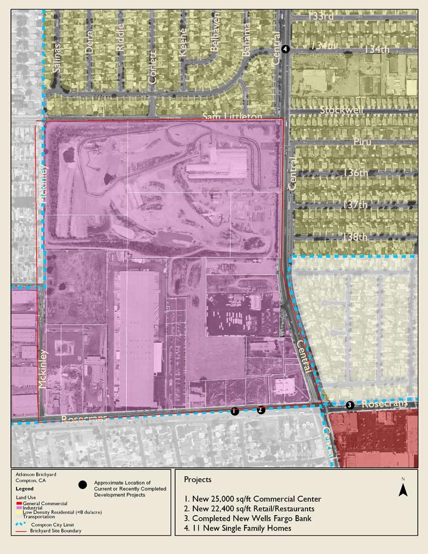
16 14


17 Brickyard The photos below are looking south at the corner of North Central Avenue and West 135th Sreet. The image at top shows what the site looks like today. The image at the bottom is a rendering of what the site could look like if policy and urban design strategies are applied
18 compton station Introduction The Metro Blue Line has two stops within Compton City boundaries. The Compton Station stop is located on Willowbrook Street on the north side of Compton Boulevard. The stop is located in the heart of the city near major shopping facilities, the Martin Luther King Transit Station and the Compton Civic Center. Several community workshops were held in Compton to better understand what residents and area stakeholders envisioned for their city. One workshop focused only on this station area. The response from this workshop included concepts of revitalizing the civic center and creating a mixed use center with local retail and office uses along with residential development. With appropriate zoning, the city can provide incentives for developers to build infill projects centered on the transit station area. Opportunities In addition to the general, optimistic development climate in Compton described previously, there are several projects being developed less than a mile from Compton Station: The Metropolitan Transportation Authority s (MTA) Long Term Transportation Plan includes expanding the Martin Luther King Transit Center, which is located across Willowbrook Avenue from the Compton Station. The City of Compton has received a grant for approximately $3.2 million from MTA to upgrade this facility. The upgrade will include improved facilities, improved transit services and storage facilities, and a Regional Traffic and Management Operations System. A new 136 unit condominium project on North Tamarind Avenue is being developed by the Olson group Just north of the station are two new duplexes on Rosecrans Avenue A new office building is being built on South Santa Fe Avenue The diversity of these projects suggests that this area is ripe with opportunities for redevelopment. The Compton Station area benefits from strong access from arterials including Compton Boulevard and Rosecrans Avenue. There are several opportunity areas in close proximity to the station. On the west side of Willowbrook Avenue there are several vacant lots which could be redevelopment sites. There is also significant lowdensity retail development along Compton Boulevard which could be redeveloped at a higher density. An advantage of this station area is its convenience to commercial services and parks. There is a warehouse grocery and a Ralph s grocery store within a quarter mile of the station. Other retailers near the station include a bank, fast food restaurants, and a drug store all services that are needed in a walkable area. To the east of the station there is a park at East Palmer Street and North Alameda Street. Challenges Although there are several developments at some stage of the planning/development process within a mile of the station area, the projects are generally spread out and may not have the effect of catalyzing other development. Currently, the predominant development types that surround the station area are low-density with large surface parking lots. A major zoning type near the station area is Light Manufacturing (ML), which does not facilitate a pedestrian-friendly mix of uses. Additionally, in terms of zoning, within close proximity to the Compton Station is an area of land zoned Parking/High Density Residential. The challenge with these zoning types is that while they may allow the highest residential-only densities currently within the City of Compton s code, they do not easily allow mixed-use development. 16
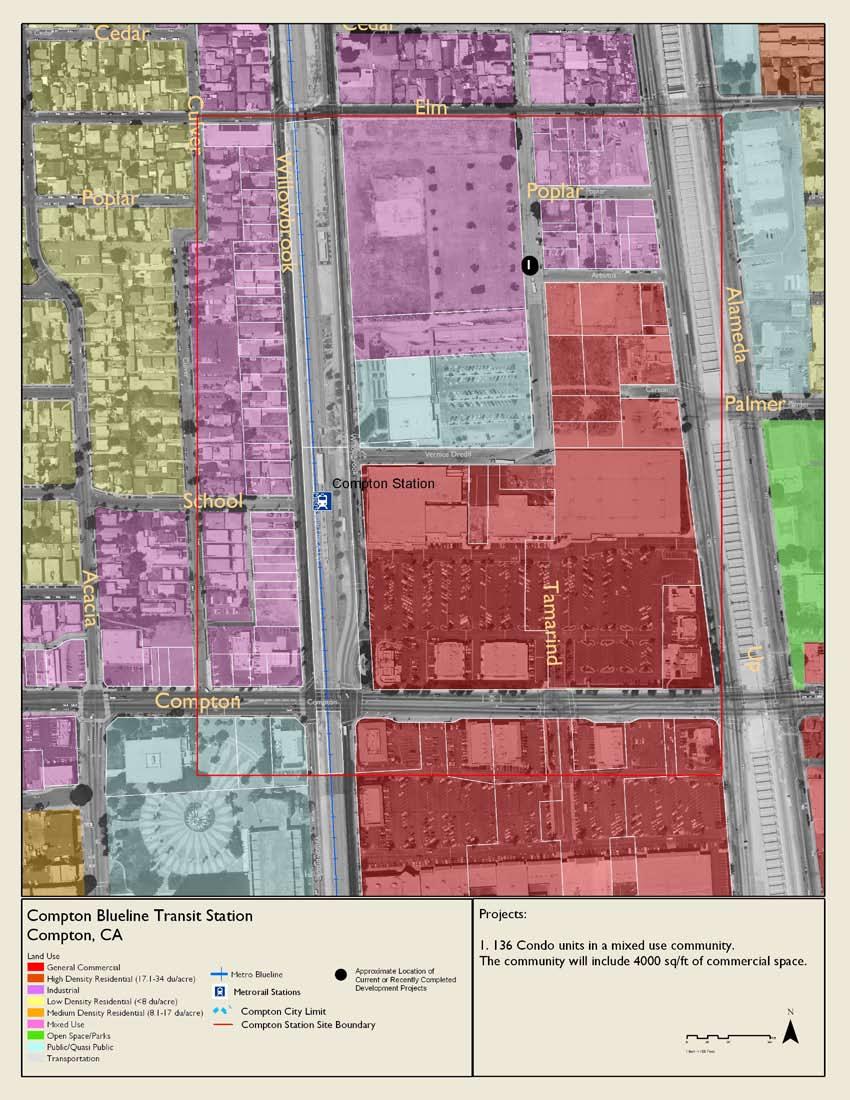
19 17 17


20 Compton Station The images below are looking northeast at West Compton Boulevard and Douglas Dollarhide Drive. The above image shows the area as it is today, the image below shows a rendering of what the area could look like. Compton Station has great potential to become a pedestrian friendly transit oreinted development. 18
21 Artesia station Introduction The Artesia station area is located along Artesia Boulevard just north of the 91 freeway and bordered by the Metro Blue Line to the West and Alameda Street to the East. The station area is immediately adjacent to the Crystal Park Casino Hotel and the old auto mall site. The station area also encompasses a large portion of Compton Creek. The majority of the site is zoned either Limited Commercial or Heavy Manufacturing. The Artesia station area is just to the west of Compton Community College, which is located on E. Artesia Boulevard. Over 6,000 students attend this college. Opportunities The Artesia Station area has the potential to develop into a vibrant Transit Oriented Development with connections to Compton Community College and the rest of the city. Encouraging investment in this station area could provide immediate local benefits through the infusion of new activity and housing as well as creating more jobs and housing located near transit. The City is already moving in this direction and with some coordination between projects can achieve this goal. The following projects, in various stages of development are currently underway: The City has already approved the development of 51 acres of the former auto mall area to include a mix of retail, commercial and residential uses. The project, called the Gateway Towne Center, will include over 500,000 square feet of retail space. The City recently leased 43 acres of land, 26 of which will be devoted to open space and parks, or as a buffer zone between industrial and residential districts. The old Edison Right-of-Way is included in this lease agreement and runs on the south side of Greenleaf Boulevard within Compton city limits. This area borders the northern end of the Artesia station area site. This has the potential to provide pedestrian and bicycle connections from the Artesia Station area to other parts of Compton while also providing important public open space. South of the 91 freeway there are new industrial and storage uses planned depending on access from the station, employment in this area could be within walking distance of the station. The Artesia station area also sits along Compton Creek, an important but neglected public resource. During the 2006 workshop held for this area, residents expressed a desire to see this portion of the creek restored and connected to a network of trails and pedestrian/cyclist pathways. With the City s recent lease of the Edison Right-of-Way, the momentum from the General Plan update, the Gateway Towne Center, and its proximity to Compton Community College, the Artesia Station area represents one of the most significant development opportunities in the City. Challenges The Artesia station is uniquely positioned for full scale redevelopment into a vibrant mixed use community with greenway connections to the rest of the City and Compton Community College. A potential redefinition of manufacturing zones as well as the new acquisition of park space adjacent to the site and the potential for restoring Compton Creek provides significant incentive for redevelopment. Another issue is the connection between this station area and Compton Community College currently the station area is very difficult to access from the campus. This connection is important because students are a key target group for transit ridership. Additionally, this may help Compton Community College serve students from more distant parts of the Los Angeles area. While the Artesia Station is close to several freeways, this proximity can also create a challenge. For example, the 91 freeway essentially creates a barrier at the southern end of the station area. Any plan for the area around Artesia Station should ensure that this area at the southern end of the City is connected to the rest of Compton through multiple transportation modes. Artesia Station has a potential amenity in nearby Compton Creek. Unfortunately, environmental remediation of Compton Creek will likely be expensive and will require public funding. Future plans for the Artesia station area should consider the clean-up of and impacts on Compton Creek
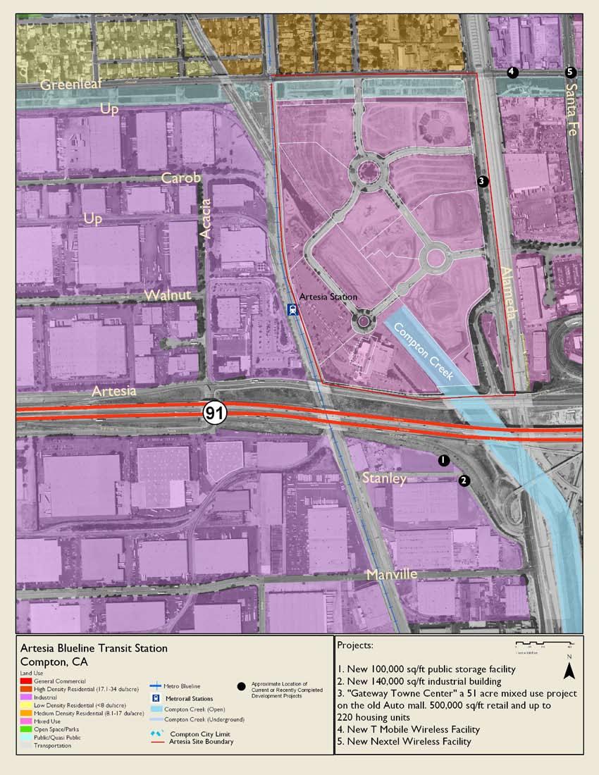
22 20


23 Artesia station The image at top shows what the Artesia Station area looking northeast on South Auto Drive near the rail line and East Artesia Boulevard. The image below illustrates what the area could look like with mixed use development
Chapter 5: Testing the Vision. Where is residential growth most likely to occur in the District? Chapter 5: Testing the Vision
 Chapter 5: Testing the Vision The East Anchorage Vision, and the subsequent strategies and actions set forth by the Plan are not merely conceptual. They are based on critical analyses that considered how
Bylaw No , being "Official Community Plan Bylaw, 2016" Schedule "A" DRAFT
 Bylaw No. 2600-2016, being "Official Community Plan Bylaw, 2016" Schedule "A" Urban Structure + Growth Plan Urban Structure Land use and growth management are among the most powerful policy tools at the
Analysis of Infill Development Potential Under the Green Line TOD Ordinance
 Analysis of Infill Development Potential Under the Green Line TOD Ordinance Prepared for the Los Angeles County Second Supervisorial District Office and the Department of Regional Planning Solimar Research
Generic Environmental Impact Statement. Build-Out Analysis. City of Buffalo, New York. Prepared by:
 Generic Environmental Impact Statement Build-Out Analysis City of Buffalo, New York 2015 Prepared by: TABLE OF CONTENTS 1.0 INTRODUCTION 1 2.0 METHODOLOGY 2 3.0 EXISTING LAND USE 3 4.0 EXISTING ZONING
Article 3. SUBURBAN (S-) NEIGHBORHOOD CONTEXT
 NEIGHBORHOOD CONTEXT") Article 3. SUBURBAN (S-) NEIGHBORHOOD CONTEXT this page left intentionally blank Contents ARTICLE 3. SUBURBAN (S-) NEIGHBORHOOD CONTEXT DIVISION 3.1 NEIGHBORHOOD CONTEXT DESCRIPTION...3.1-1 Section 3.1.1
Article 3. SUBURBAN (S-) NEIGHBORHOOD CONTEXT this page left intentionally blank Contents ARTICLE 3. SUBURBAN (S-) NEIGHBORHOOD CONTEXT DIVISION 3.1 NEIGHBORHOOD CONTEXT DESCRIPTION...3.1-1 Section 3.1.1
GETTING IT BUILT: OVERCOMING THE IMPLEMENTATION BARRIERS TO SMART GROWTH
 GETTING IT BUILT: OVERCOMING THE IMPLEMENTATION BARRIERS TO SMART GROWTH February 15, 2014 New Partners for Smart Growth Dena Belzer Challenges to Implementing Smart Growth The Typical Smart Growth Vision
DRAFT. Amendment to the Master Plan Land Use Element for Block 5002, Lot Township of Teaneck, Bergen County, New Jersey.
 DRAFT Amendment to the Master Plan Land Use Element for Block 5002, Lot 18.01 Township of Teaneck, Bergen County, New Jersey Prepared for: Township of Teaneck Planning Board Prepared by: Janice Talley,
Truax Park Apartments
 Truax Park Apartments Master Planning and Site Development Study Prepared by The Community Development Authority of the City of Madison In association with SMITH & SMITH ASSOCIATES, Inc CONSTRUCTION COST
forwarddallas! Development Code Amendments Approach Quality of Life Committee Briefing June 11, 2007
 1 forwarddallas! Development Code Amendments Approach Quality of Life Committee Briefing June 11, 2007 2 Project Background The forwarddallas! Comprehensive Plan provides the foundation and launching pad
Appendix A: Guide to Zoning Categories Prince George's County, Maryland
 Appendix A: Guide to Zoning Categories Prince George's County, Maryland RESIDENTIAL ZONES 1 Updated November 2010 R-O-S: Reserved Open Space - Provides for permanent maintenance of certain areas of land
LITTLE MOUNTAIN ADJACENT AREA REZONING POLICY
 LITTLE MOUNTAIN ADJACENT AREA REZONING POLICY JANUARY 2013 CONTENTS 1.0 INTENT & PRINCIPLES...1 2.0 APPLICATION...2 3.0 HOUSING TYPES, HEIGHT & DENSITY POLICIES...3 3.1 LOW TO MID-RISE APARTMENT POLICIES...4
Chapter 10: Implementation
 Chapter 10: Introduction Once the Comprehensive Plan has been adopted by the City of Oakdale, the City can begin to implement the goals and strategies to make this vision a reality. This chapter will set
UPDATE Board of Selectmen June 20, 2017
 MAPLE STREET I-1 AREA DRAFT ZONING BYLAW & DEVELOPMENT STANDARDS Town of Danvers, MA UPDATE Board of Selectmen June 20, 2017 The Danvers Team: Brovitz Community Planning & Design Dodson & Flinker Danvers
Poughkeepsie City Center Revitalization Plan
 Purpose and Need Purpose Increase job and educational opportunities for all residents Maximize fiscal productivity of downtown land uses Diversify retail mix Eliminate surface and building vacancies Create
Article Optional Method Requirements
 Article 59-6. Optional Method Requirements [DIV. 6.1. MPDU DEVELOPMENT IN RURAL RESIDENTIAL AND RESIDENTIAL ZONES Sec. 6.1.1. General Requirements... 6 2 Sec. 6.1.2. General Site and Building Type Mix...
Place Type Descriptions Vision 2037 Comprehensive Plan
 Place Type Descriptions Vision 2037 Comprehensive Plan The Vision 2037 Comprehensive Plan establishes a range of place types for Oxford, ranging from low intensity (limited development) Rural and Natural
TASK 2 INITIAL REVIEW AND ANALYSIS U.S. 301/GALL BOULEVARD CORRIDOR FORM-BASED CODE
 TASK 2 INITIAL REVIEW AND ANALYSIS U.S. 301/GALL BOULEVARD CORRIDOR FORM-BASED CODE INTRODUCTION Using the framework established by the U.S. 301/Gall Boulevard Corridor Regulating Plan (Regulating Plan),
PLANNED UNIT DEVELOPMENT & SUBDIVISION STAFF REPORT Date: April 18, 2019
 PLANNED UNIT DEVELOPMENT & SUBDIVISION STAFF REPORT Date: April 18, 2019 DEVELOPMENT NAME SUBDIVISION NAME Springhill Village Subdivision Springhill Village Subdivision LOCATION 4350, 4354, 4356, 4358,
GENERAL PLAN UPDATE SPECIFIC AREAS OF THE CITY
 GENERAL PLAN UPDATE SPECIFIC AREAS OF THE CITY Background There are a total of 14 specific areas that are being reviewed as part of the update of the General Plan. Requests to review these areas came from
DRAFT FOR DISCUSSION PURPOSES ONLY. Port Credit Local Area Plan Built Form Guidelines and Standards DRAFT For Discussion Purposes
 Port Credit Local Area Plan Built Form Guidelines and Standards DRAFT For Discussion Purposes 1 Local Area Plan - Project Alignment Overview Directions Report, October 2008 (General Summary Of Selected
Salem HNA and EOA Advisory Committee Meeting #6
 Salem HNA and EOA Advisory Committee Meeting #6 Residential Land Policies Employment Land Policies Policy Discussions with the Committee Outcome of today s meeting Direction from this Committee on proposed
From Policy to Reality
 From Policy to Reality Updated ^ Model Ordinances for Sustainable Development 2000 Environmental Quality Board 2008 Minnesota Pollution Control Agency Funded by a Minnesota Pollution Control Agency Sustainable
Introduction. General Development Standards
 Introduction The development standards will set the zoning regulations for the East Park development. This section will illustrate lot standards, approximate open space locations and road standards. The
Downtown Development Focus Area: I. Existing Conditions
 Downtown Development Focus Area: I. Existing Conditions The Downtown Development Focus Area is situated along Route 1, south of the train tracks, except for the existing Unilever property. It extends west
PLANNING AND REGULATING HOUSING OPTIONS FOR CHANGING DEMOGRAPHICS
 PLANNING AND REGULATING HOUSING OPTIONS FOR CHANGING DEMOGRAPHICS New Partners for Smart Growth Conference February 2017 HOUSING MARKETS Significant increase in rental housing Offset robust single-family
ARTICLE 3: Zone Districts
 ARTICLE 3: Zone Districts... 3-1 17.3.1: General...3-1 17.3.1.1: Purpose and Intent... 3-1 17.3.2: Districts and Maps...3-1 17.3.2.1: Applicability... 3-1 17.3.2.2: Creation of Districts... 3-1 17.3.2.3:
PUBLIC REVIEW DRAFT OF OFF-STREET PARKING PROPOSAL CITY OF OAKLAND PLANNING DEPARTMENT OCTOBER 2015
 PUBLIC REVIEW DRAFT OF OFF-STREET PARKING PROPOSAL CITY OF OAKLAND PLANNING DEPARTMENT OCTOBER 2015 1. Downtown Parking Minimums Problem: The current regulations do not prescribe a minimum amount of required
Using Analysis to Improve the Environment for Transit
 Using Analysis to Improve the Environment for Transit POWERFUL ANALYTIC TOOLS Envision Tomorrow/ process Step 1: Scenario development starts by creating a library of building types that are financially
density framework ILLUSTRATION 3: DENSITY (4:1 FSR) EXPRESSED THROUGH BUILT FORM Example 1
 EXPRESSED THROUGH BUILT FORM Example 1") density framework 4 ILLUSTRATION 3: DENSITY (4:1 FSR) EXPRESSED THROUGH BUILT FORM INTRODUCTION The Downtown Core Area contains a broad range of building forms within its relatively compact area. These
density framework 4 ILLUSTRATION 3: DENSITY (4:1 FSR) EXPRESSED THROUGH BUILT FORM INTRODUCTION The Downtown Core Area contains a broad range of building forms within its relatively compact area. These
Public Review of the Slot Home Text Amendment
 Public Review of the Slot Home Text Amendment The proposed amendments to the Denver Zoning Code have been informed by the Slot Home Strategy Report. This document has been developed out of a robust process
Table of Contents. Concept Plan Overview. Statement of Compliance with Design Guidelines. Statement of Compliance with Comprehensive Plan
 Table of Contents Concept Plan Overview Statement of Compliance with Design Guidelines Statement of Compliance with Comprehensive Plan Developer s Program Market Objective Benefit to Local Businesses Benefit
Goal 1 - Retain and enhance Cherry Creek North s unique physical character.
 Introduction This document summarizes the proposed new zoning for the area of roughly bordered by University Boulevard, Steele Street, 3rd Avenue, and 1st Avenue. It provides a high-level review of the
College Avenue. Sowers Street. Calder Way. Beaver Avenue
 K L M Illustrative Master Plan: Collegiate District Calder Way Beaver Avenue High Street ner 16 Sowers Street Stre et 17 Hetzel Street 18 Gar Heister Street 15 Collegiate District 183 4-C: East End Collegiate
2.0 LAND USE FRAMEWORK
 Land Use Framework 2.0 LAND USE FRAMEWORK FOLSOM BOULEVARD 2.1 LAND USE OVERVIEW The proposed land uses for Easton Place offer local and regional employment, shopping, and entertainment, highlighting the
Evolution of the Vision for NE 181st Street Study Area
 City Council Action on NE 181 St Street Study Area Evolution of the Vision for NE 181st Street Study Area such uses to ensure neighborhood compatibility. More intense uses may be allowed through a conditional
Planning Justification Report
 Planning Justification Report Kellogg s Lands City of London E&E McLaughlin Ltd. June 14, 2017 Zelinka Priamo Ltd. Page i TABLE OF CONTENTS Page No. 1.0 2.0 2.1 2.2 3.0 4.0 5.0 5.1 5.2 5.3 5.4 5.5 5.6
PLANNING COMMISSION WILLIAMSBURG, VIRGINIA WORK SESSION AGENDA Wednesday, May 23, 2012
 PLANNING COMMISSION WILLIAMSBURG, VIRGINIA WORK SESSION AGENDA Wednesday, May 23, 2012 The meeting will be called to order in the third floor Conference Room (Room 310), Williamsburg Municipal Building,
Planning Justification Report
 Planning Justification Report 101 Kozlov Street, Barrie, Ont. Destaron Property Management Ltd. November 2015 Revised February 2017 TABLE OF CONTENTS Page 1.0 INTRODUCTION... 1 2.0 DESCRIPTION OF SUBJECT
Summary of Findings & Recommendations
 Summary of Findings & Recommendations Minneapolis/St. Paul Region Mixed Income Housing Feasibility, Education and Action Project Background In 2015 and 2016, the Family Housing Fund and the Urban Land
Bunker Hill Part II Urban Design. Specific Plan. Case No. CPC SP TABLE OF CONTENTS
 Bunker Hill Part II Urban Design Specific Plan Case No. CPC-2011-684-SP TABLE OF CONTENTS Section 1. Section 2. Section 3. Section 4. Section 5. Section 6. Section 7. Section 8. Section 9. Section 10.
Streamlining the Entitlement Process for Transit-Oriented Development
 October 2012 Streamlining the Entitlement Process for Transit-Oriented Development Best Practices Summary Setting Ideas in Motion Introduction and Overview Entitlement Process: The legal method of obtaining
GOALS, OBJECTIVES, AND STRATEGIES
 GOALS, OBJECTIVES, AND STRATEGIES What follows is a series of goals, recommendations and actions that reflect the themes outlined in the Mineral Springs Vision Plan (incorporated into this document as
Ashland Transit Triangle:
 Ashland Transit Triangle: Strategic Approach to Implementation Fregonese Associates Inc. 12/19/16 Phase I of the Transit Triangle Study Conducted in the Fall of 2015 Tasks Completed: Market analysis Initial
Town of Clinton, Connecticut Action Plan for the Historic Unilever Property and Area. Steering Committee Meeting #5 Implementation Strategies
 Town of Clinton, Connecticut Action Plan for the Historic Unilever Property and Area Steering Committee Meeting #5 Implementation Strategies Wednesday, March 19, 2014 6:30pm Steering Committee Meeting
Puyallup Downtown Planned Action & Code Changes. January 10, 2017
 Puyallup Downtown Planned Action & Code Changes January 10, 2017 Purpose & Location Purpose Promote economic development and downtown revitalization Tools: Municipal Code amendments Change development
Ann Arbor Downtown Zoning Evaluation
 Ann Arbor Downtown Zoning Evaluation Options Workbook ENP & Associates in cooperation with the City of Ann Arbor September, 2013 Photo Courtesy of Andrew Horne, February 9, 2013 Introduction Thank you
Parking Challenges and Trade-Offs
 Parking Challenges and Trade-Offs What is the best way to balance competing interests and priorities while updating the City s off street parking regulations? Updating off street parking regulations can
THE REDEVELOPMENT PLAN
 PAGE 37 THE REDEVELOPMENT PLAN FUTURE LAND USE The Silver Terrace Redevelopment Area is currently designated as Redevelopment Area #4 on the City of Delray Beach Future Land Use Map (FLUM). This designation
7. IMPLEMENTATION STRATEGIES
 7. IMPLEMENTATION STRATEGIES A. GENERAL APPROACH FOR IMPLEMENTATION Implementing the plan will engage many players, including the Municipality of Anchorage (MOA), the Government Hill Community Council,
Staff Report & Recommendation Rezoning Case RZ Date of Report: June 6, 2014 Report by: Doug Stacks
 Staff Report & Recommendation Rezoning Case RZ-2014-02 Date of Report: June 6, 2014 Report by: Doug Stacks Hearing Dates: Planning Commission June 26, 2014 Mayor and Council July 14, 2014 GENERAL INFORMATION
MERIDEN TOD A NEW TRANSIT-ORIENTED DEVELOPMENT DISTRICT ZONING REGULATION FOR MERIDEN. Greater Meriden Chamber & Connecticut Bar Association
 A NEW TRANSIT-ORIENTED DEVELOPMENT DISTRICT ZONING REGULATION FOR MERIDEN PRESENTATION TO Greater Meriden Chamber & Connecticut Bar Association 25 September 2013 Dominick J. Caruso, AICP Director of Planning
DRAFT Plan Incentives. Part A: Basic Discount
 DRAFT 2030 Plan Incentives July 26, 2006 Part A: Basic Discount In order for a development to be eligible for any 2030 Land Resource Management Plan Discounts it must be located in the Urban Corridor and
APPENDIX D: DEFINITIONS
 D APPENDIX D: DEFINITIONS Terms used throughout the 2040 Comprehensive Plan should be interpreted using the definitions provided in this appendix. For interpretation of any term not defined, defer to the
ZONING CITY ACREAGE PERCENT OF CITY ACREAGE TOTAL. Residential Low (RL) 1, % Residential Medium (RM) % Residential High (RH) 228.
 1, % Residential Medium (RM) % Residential High (RH) 228.") PLANNING AND ECONOMIC DEVELOPMENT 200 NE Moe Street Poulsbo, Washington 98370 (360) 394-9748 fax (360) 697-8269 www.cityofpoulsbo.com plan&econ@cityofpoulsbo.com MEMO To: City Council and Mayor Erickson
PLANNING AND ECONOMIC DEVELOPMENT 200 NE Moe Street Poulsbo, Washington 98370 (360) 394-9748 fax (360) 697-8269 www.cityofpoulsbo.com plan&econ@cityofpoulsbo.com MEMO To: City Council and Mayor Erickson
Urban Design Brief Dundas Street. London Affordable Housing Foundation. November Zelinka Priamo Ltd.
 Urban Design Brief 1039-1047 Dundas Street London Affordable Housing Foundation November 2017 Zelinka Priamo Ltd. TABLE OF CONTENTS Page No. INTRODUCTION... 3 SECTION 1 LAND USE PLANNING CONTEXT... 3 1.1
PC Staff Report 11/18/2013 Z Item No. 1-1
 Z-13-00401 Item No. 1-1 PLANNING COMMISSION REPORT Regular Agenda - Public Hearing Item PC Staff Report 11/18/2013 ITEM NO. 1: Z-13-00401 IG (General Industrial) District TO CS (Strip Commercial) District;
Provide a diversity of housing types, responsive to household size, income and age needs.
 8 The City of San Mateo is a highly desirable place to live. Housing costs are comparably high. For these reasons, there is a strong and growing need for affordable housing. This chapter addresses the
Wheaton Sector Plan. Preliminary. Recommendations. Montgomery County Planning Board
 Sector Plan Preliminary Recommendations Montgomery County Planning Board 12-03-09 Scope of Work September 2008 Status Report June 2009 Preliminary Recommendations December 2009 1952 Process Today Community
City of Tacoma Planning and Development Services
 Agenda Item D-3 City of Tacoma Planning and Development Services To: Planning Commission From: Elliott Barnett, Planning Services Division Subject: Affordable Housing Planning Work Program (Phase 3) Meeting
PROPOSED METRO JOINT DEVELOPMENT PROGRAM: POLICIES AND PROCESS July 2015 ATTACHMENT B
 PROPOSED METRO JOINT DEVELOPMENT PROGRAM: POLICIES AND PROCESS ATTACHMENT B TABLE OF CONTENTS I. INTRODUCTION / PURPOSE............................ 3 II. OBJECTIVES / GOALS..................................
Residential. Infill / Intensification Development Review
 Residential Infill / Intensification Development Review How Best to Manage The Compatible Integration of New Housing Within Established Residential Neighbourhoods Identification of Issues Privacy/overlook/height
Reviewing Mixed Use Proposals
 MIXED USE ZONING Citizens Guide Supplement 1 Things to Consider in Reviewing Mixed Use Proposals Using an Overlay District vs. Changing Underlying Zoning To achieve well-planned mixed use development,
3.1. OBJECTIVES FOR RESIDENTIAL LAND USE DESIGNATIONS GENERAL OBJECTIVES FOR ALL RESIDENTIAL DESIGNATIONS
 3. RESIDENTIAL LAND USE DESIGNATIONS INTRODUCTION The Residential land use designations provide for housing and other land uses that are integral to, and supportive of, a residential environment. Housing
SUBJECT: AMENDMENTS TO TITLE 13 DATE: June 5, 2017 OF THE SAN JOSE MUNICIPAL CODE
 COUNCIL AGENDA: 06/27/17 ITEM: 4.5 CITY OF cr SAN JOSE CAPITAL OF SILICON VALLEY Memorandum TO: HONORABLE MAYOR AND CITY COUNCIL FROM: Barry Ng Rosalynn Hughey SUBJECT: AMENDMENTS TO TITLE 13 DATE: June
DEVELOPMENT STANDARDS FOR RESIDENTIAL PROJECTS RESIDENTIAL BUILDING TYPES: APPROPRIATE ZONES AND DENSITIES 2-1
 2 DEVELOPMENT STANDARDS FOR RESIDENTIAL PROJECTS RESIDENTIAL BUILDING TYPES: APPROPRIATE ZONES AND DENSITIES 2-1 This Chapter presents the development standards for residential projects. Section 2.1 discusses
TRANSIT-ORIENTED DEVELOPMENT PLAN EXISTING CONDITIONS REPORT LAWRENCE TO BRYN MAWR MODERNIZATION
 TRANSIT-ORIENTED DEVELOPMENT PLAN EXISTING CONDITIONS REPORT LAWRENCE TO BRYN MAWR MODERNIZATION March 2018- FINAL DRAFT SITE SPECIFIC DEVELOPMENT CONCEPTS SITE SPECIFIC DEVELOPMENT CONCEPTS This report
8.5.1 R1, Single Detached Residential District
 8.5.1 R1, Single Detached Residential District The purpose of this district is to provide for residential development in the form of single detached dwellings. Dwelling, Single Detached Home Business,
Barbara County Housing Element. Table 5.1 Proposed Draft Housing Element Goals, Policies and Programs
 Table 5.1 Proposed Draft Housing Element Goals, Policies and Programs Goal 1: Enhance the Diversity, Quantity, and Quality of the Housing Supply Policy 1.1: Promote new housing opportunities adjacent to
Upcoming Apartment Projects with No On-Site Parking Frequently Asked Questions June 2012
 Upcoming Apartment Projects with No On-Site Parking Frequently Asked Questions June 2012 Recent proposals to construct apartment buildings with no on-site parking along many of Portland s commercial streets
David J. Gellner, AICP, Principal Planner, ,
 Staff Report PLANNING DIVISION COMMUNITY & ECONOMIC DEVELOPMENT To: From: Salt Lake City Planning Commission David J. Gellner, AICP, Principal Planner, 801-535-6107, david.gellner@slcgov.com Date: March
Housing. Approved and Adopted by City Council November 13, City Council Resolution City Council Resolution
 5 Housing Approved and Adopted by City Council November 13, 2018 Chapter 5 Housing 5.1 City Council Resolution 2018-096 5.2 Fontana General Plan CHAPTER 5 Housing This chapter of the General Plan Update
2015 Downtown Parking Study
 2015 Downtown Parking Study City of Linden Genesee County, Michigan November 2015 Prepared by: City of Linden Downtown Development Authority 132 E. Broad Street Linden, MI 48451 www.lindenmi.us Table of
CITY OF PORTSMOUTH. CITY COUNCIL POLICY No HOUSING POLICY
 CITY OF PORTSMOUTH CITY COUNCIL POLICY No. 2016-03 HOUSING POLICY WHEREAS, the goals of the City of Portsmouth, as expressed in its 2025 Master Plan, include encouraging walkable mixed-use development,
Planning Rationale in Support of an Application for Plan of Subdivision and Zoning By-Law Amendment
 Planning Rationale in Support of an Application for Plan of Subdivision and Zoning By-Law Amendment The Kilmorie Development 21 Withrow Avenue City of Ottawa Prepared by: Holzman Consultants Inc. Land
Future Land Use Categories & Nodes December 23, Future Land Use Categories
 Future Land Use Categories & Nodes December 23, 2015 A note regarding nodes: Descriptions for nodes are located in the general recommendations handout. Node locations are set in part by the Auburn Interactive
REZONING GUIDE. Zone Map Amendment (Rezoning) - Application. Rezoning Application Page 1 of 3. Return completed form to
 - Application. Rezoning Application Page 1 of 3. Return completed form to") COMMUNITY PLANNING & DEVELOPMENT REZONING GUIDE Rezoning Application Page 1 of 3 Zone Map Amendment (Rezoning) - Application PROPERTY OWNER INFORMATION* PROPERTY OWNER(S) REPRESENTATIVE** CHECK IF POINT
COMMUNITY PLANNING & DEVELOPMENT REZONING GUIDE Rezoning Application Page 1 of 3 Zone Map Amendment (Rezoning) - Application PROPERTY OWNER INFORMATION* PROPERTY OWNER(S) REPRESENTATIVE** CHECK IF POINT
EXHIBIT 1 PROJECT DESCRIPTION AND DESCRIPTION OF REQUESTED AREA VARIANCES REDEVELOPMENT OF 201 ELLICOTT STREET
 EXHIBIT 1 PROJECT DESCRIPTION AND DESCRIPTION OF REQUESTED AREA VARIANCES REDEVELOPMENT OF 201 ELLICOTT STREET I. PROJECT DESCRIPTION: Ciminelli Real Estate Corporation (the Applicant ) is seeking area
Kassner Goodspeed Architects Ltd.
 Kassner Goodspeed Architects Ltd. 29 & State Street Developments Ltd. The Promenade at Robie South Case 20761: Application for Development Agreement Design Rationale The land assembly is a 1.3 Acre parcel
Sherwood Forest (Trinity) Housing Corporation. Urban Design Brief
 Housing Corporation. Urban Design Brief") Sherwood Forest (Trinity) Housing Corporation Sherwood Place Affordable Housing Apartments Trinity Presbyterian Church Orchard Park Nursery School 590 Gainsborough Road, London Urban Design Brief REVISED
Sherwood Forest (Trinity) Housing Corporation Sherwood Place Affordable Housing Apartments Trinity Presbyterian Church Orchard Park Nursery School 590 Gainsborough Road, London Urban Design Brief REVISED
CENTENNIAL NEIGHBOURHOODS SECONDARY PLAN STUDY. City of Hamilton
 CENTENNIAL NEIGHBOURHOODS SECONDARY PLAN STUDY City of Hamilton PUBLIC EVENT #3 APRIL 2016 MEETING PURPOSE Recap of previous sessions/how we got here The purpose of this session is to provide an opportunity
1.0 Introduction. November 9, 2017
 November 9, 2017 Andrew Bone, Planner III Regional Planning Policy and Strategic Initiatives Halifax Regional Municipality 40 Alderney Drive Dartmouth, NS, B2Y 2N5 Subject: Application to amend the Bedford
STAFF REPORT. Permit Number: Unlimited. Kitsap County Board of Commissioners; Kitsap County Planning Commission
 STAFF REPORT Permit Number: 15 00550 Unlimited DATE: March 2, 2016 TO: FROM: Kitsap County Board of Commissioners; Kitsap County Planning Commission Katrina Knutson, AICP, Senior Planner, DCD and Jeff
4 LAND USE 4.1 OBJECTIVES
 4 LAND USE The Land Use Element of the Specific Plan establishes objectives, policies, and standards for the distribution, location and extent of land uses to be permitted in the Central Larkspur Specific
4 DEVELOPMENT STANDARDS FOR
 4 DEVELOPMENT STANDARDS FOR RESIDENTIAL MIXED-USE PROJECTS This chapter presents standards for residential mixed-use projects in the Ashland-Cherryland Business District and the Castro Valley Central Business
Missing Middle Housing Types Showcasing examples in Springfield, Oregon
 Missing Middle Housing Types Showcasing examples in Springfield, Oregon MissingMiddleHousing.com is powered by Opticos Design Illustration 2015 Opticos Design, Inc. Missing Middle Housing Study Prepared
LAKE MERRITT STATION AREA PLAN
 LAKE MERRITT STATION AREA PLAN Emerging Plan Open House Summary October 2011 2 1 Introduction The City of Oakland, Bay Area Rapid Transit (BART), and the Peralta Community College District, through a grant
Town of Cary, North Carolina Rezoning Staff Report 12-REZ-27 Morris Branch Town Council Public Hearing January 24, 2013
 Town of Cary, North Carolina Rezoning Staff Report 12-REZ-27 Morris Branch Town Council Public Hearing January 24, 2013 REQUEST To amend the Town of Cary Official Zoning Map to rezone approximately 9.0
Residences at Grove Park 425 Hillsborough St. Chapel Hill, NC
 9 ATTACHMENT 1 Residences at Grove Park 425 Hillsborough St. Chapel Hill, NC Zoning Atlas Amendment Application Statement of Justification December 12 th, 2008 Introduction This is a request for a Zoning
BUILDING HEIGHTS. The following diagram depicts the maximum allowable building height in a +3 zone.
 BUILDING HEIGHTS The following diagram depicts the allowable building height in a +1 zone in an area with substantial topography. As the diagram demonstrates, the building has 4 floors (and would have
Director, Community Planning, Toronto and East York District
 STAFF REPORT September 1, 2005 To: From: Subject: Toronto and East York Community Council Director, Community Planning, Toronto and East York District Further Report Applications to amend Official Plan
WELCOME. Imagining New Communities. Open House. Planning & economic development department
 WELCOME Imagining New Open House Why are we Here? The City of Hamilton is working on several projects related to residential growth. The City is here to present an overview of the concepts behind these
The Miramar Santa Monica
 The Miramar Santa Monica Project Description The Santa Monica Miramar Hotel (the Miramar or the Hotel ) has been an institution in the City of Santa Monica since originally opening on the site in 1920.
City of Tacoma Zoning Reference Guide
 City of Tacoma Zoning Reference Guide Planning and Development Services 747 Market Street, Room 345 Tacoma, WA 98402 (253) 591-5577 This document should not be used as a substitute for codes and regulations.
DOWNTOWN BEAUMONT CENTRE-VILLE: PARKING MANAGEMENT REPORT
 DOWNTOWN BEAUMONT CENTRE-VILLE: PARKING MANAGEMENT REPORT Prepared for: Prepared by: Town of Beaumont Planning & Development Services WATT Consulting Group Our File: 3364.T01 Date: October 5, 2016 1.0
GENERAL DESCRIPTION STAFF RECOMMENDATION IMPLEMENTATION REQUIREMENTS
 Application No.: 891418 Applicant: AREA-WIDE MAP AMENDMENT Rezone two parcels from Moderate Density Single Family (MSF) to Neighborhood Center (NC) and Employment Center (EC). Charles Bitton GENERAL DESCRIPTION
Detroit Neighborhood Housing Markets
 Detroit Neighborhood Housing Markets Market Study 2016 In 2016, Capital Impact s Detroit Program worked with local and national experts to determine the residential market demand across income levels for
PLAINFIELD CHARTER TOWNSHIP COMMUNITY DEVELOPMENT DEPARTMENT PLANNING, ZONING & BUILDING SERVICES MEMORANDUM
 PLAINFIELD CHARTER TOWNSHIP COMMUNITY DEVELOPMENT DEPARTMENT PLANNING, ZONING & BUILDING SERVICES 6161 BELMONT AVENUE N.E. BELMONT, MI 49306 PHONE 616-364-1190 FAX: 616-364-1170 www.plainfieldchartertwp.org
CITY OF KAMLOOPS BYLAW NO A BYLAW TO AMEND THE ZONING BYLAW OF THE CITY OF KAMLOOPS
 67 68 CITY OF KAMLOOPS BYLAW NO. 5-1-2796 A BYLAW TO AMEND THE ZONING BYLAW OF THE CITY OF KAMLOOPS The Municipal Council of the City of Kamloops, in open meeting assembled, enacts as follows: 1. This
1999 Town Center West Proposal
 Crescent Square June 10, 2014 Page 2 1999 Town Center West Proposal Food-4- Less Retail Not a Part On June 10, 2004, the City Council and Planning Commission conducted a joint workshop to review conceptual
ARTICLE OPTIONAL METHOD REGULATIONS
 ARTICLE 59-6. OPTIONAL METHOD REGULATIONS DIV. 6.1. MPDU DEVELOPMENT IN RURAL RESIDENTIAL AND RESIDENTIAL ZONES SEC. 6.1.1. GENERAL REQUIREMENTS... 6 2 SEC. 6.1.2. GENERAL SITE AND BUILDING T PE MIX...