DOWNTOWN DANVERS C1-C1A DISTRICTS NEW ZONING BYLAW & DESIGN STANDARDS Town of Danvers, MA
|
|
|
- Elfrieda Barrett
- 5 years ago
- Views:
Transcription

1 DOWNTOWN DANVERS C1-C1A DISTRICTS NEW ZONING BYLAW & DESIGN STANDARDS Town of Danvers, MA PUBLIC KICK-OFF MEETING & LISTENING SESSION Planning Board May 8, 2018 The Danvers Team: Brovitz Community Planning & Design Dodson & Flinker
2 PROJECT SCOPE AND SCHEDULE TASKS Part 1: Project Area Evaluation Project Kick-Off and Listening Session 1.2 Review Relevant Plans and Studies 1.3 Analysis of Land Use and Development Patterns Deliverable: Existing Conditions, Challenges, and Opportunities Map Part 2: Public Visioning Stakeholder Meetings 2.2 Mixed Use and Public Realm Concept Plan 2.3 Prepare Preliminary Recommendations Planning Board Workshop and Meetings (10) Deliverable: Preferred Development & Public Realm Concept Plan Part 3: Prepare Design Guidelines 3.1 Prepare Preliminary Design Guidelines 3.2 Present Preliminary Design Guidelines 3.3 Prepare Final Draft Design Guidelines Deliverable: Final Design Guidelines Part 4: Prepare Zoning Amendments SCHEDULE MAR-APR APR-JUN JUN-SEPT 4.1 Prepare Draft Zoning Amendments 4.2 Prepare Draft Zoning Map JUNE-SEPT Public Forum 4.4 Refine and Complete Final Zoning Bylaws and Design Guidelines Deliverable: Final Zoning Bylaw, Design Guidelines and Zoning Map PROJECT COMPLETION: SEPT. 30
 Study (2009) Danversport Rezoning (2010) and Tapleyville Mixed Use Overlay District Zoning Bylaw (2014) Danvers Housing")
 Downtown Area Traffic Management Report (2017) Danvers Wayfinding Project (2017) Maple Street I-1 Area Vision Plan &")
3 DANVERS PLANNING INITIATIVES Downtown Danvers Improvement Plan (1980s) Danvers Zoning Bylaw Review & Recommendations (2006) Danvers Mixed-Use Industrial-1 (I-1) Study (2009) Danversport Rezoning (2010) and Tapleyville Mixed Use Overlay District Zoning Bylaw (2014) Danvers Housing Production Plan (2014) Danvers Bicycle Network & Pedestrian Priority Plan (2015) Danvers Maple Street I-1 District Action Plan (2015) Downtown Danvers Parking Study (2015) Downtown Area Traffic Management Report (2017) Danvers Wayfinding Project (2017) Maple Street I-1 Area Vision Plan & C40R Zoning Code (2017)

4 PROJECT AREA EVALUATION PLACEMAKING REPORT Background and Context Project Kick Off Summary Development Patterns and the Public Realm Property Uses and Characteristics Relevant Planning Resource Evaluation Current Zoning Evaluation Challenges and Opportunities Future Vision and Recommendations


5 PROJECT AREA EVALUATION CONTEXT AND HISTORY Downtown C1 and C1A Project Area and Danvers Square Neighborhood

6 PROJECT AREA EVALUATION DEVELOPMENT PATTERNS 20 blocks in project area Average block length is 272 feet ( ideal for walkability Street ROW widths feet (Danvers Square up to 140 feet Most buildings within 20 feet of sidewalk Most parking located behind buildings.
 Average floor area ratio (FAR) of.")
7 PROJECT AREA EVALUATION EXISTING PROPERTY CHARACTERISTICS 142 parcels and 25.2 acres in the project area Ave. lot size 9,806 SF (several < 5,000 SF) 127 buildingsaverage 110 years old (1908) Ave. building size is 6,872 GFA (range 940 SF cottages to 70,000SF office building) Average floor area ratio (FAR) of.95 Most common property uses: Stores and office buildings but several mixed use and residential buildings. Estimated 220 dwelling units. Average residential density of 18 units/acre. Most common residential building types are SF homes, condo, and apartment buildings with 4 to 8 units.
 Danvers Square Plaza - Seg 1 0 0 Danvers Square Plaza - Seg 2 Danvers Rail Trail High Street")


8 PROJECT AREA EVALUATION DOWNTOWN AREA OPEN SPACE Location Walking Distance from Danvers Square Walking Time (Minutes) Danvers Square Plaza - Seg Danvers Square Plaza - Seg 2 Danvers Rail Trail High Street Historic Cemetery Town Hall/Sylvan Square Danvers Park Great Oak Elementary School Danvers YMCA 341 1, ,434 1,412 4,729 3,099 Meadows Park 2,855 Peabody Library and Mill Pond 2,122 Walnut Grove Cemetery Rebecca Nurse Homestead 2,379 4,751 < 1 minute Moulton Park ,472 Average walking speed is 4.5 feet per section A 5 minute walk is approx. equal to 1/4 mile (or 1,320 linear feet)


9 PROJECT AREA EVALUATION DOWNTOWN AREA THOROUGHFARES Streets, Sidewalk & Pedestrian Crosswalks DOWNTOWN PROJECT AREA THOROUGHFARES & STREETSCAPE CHARACTERISTICS Street Orientation Segment One-Way Two-Way Typ. ROW Length Width On-Street Parking Sidewalks Gould Street NW to SE Park St to High St 2-Way Side (W) West Side Maple Street NW to SE Locust St to Lummus Ave 2-Way Both Sides Both Sides Maple Street NW to SE Lummus Ave to School St 2-Way Both Sides Both Sides Maple Street NW to SE School St to Cottage Ave 2-Way Both Sides Both Sides Maple Street NW to SE Cottage Ave to Central Ave 2-Way /108 Both Sides Both Sides Maple Street NW to SE Central Ave to Conant St 2-Way /140 Both Sides Both Sides Maple St High Street NW to SE Conant St to Park St 2-Way /60 Both Sides Both Sides High Street NW to SE Park St to Gould St 2-Way Both Sides Both Sides Alden Street NW to SE Conant St to Park St 2-Way Side (W) Both Sides Danvers Rail Trail SW to NE Oak St to Pickering St 2-Way Not Permitted None Elm St

10 PROJECT AREA EVALUATION PUBLIC REALM INTERFACE


11 CURRENT ZONING Allowed Uses Dimensional Standards Parking and Access Requirements Sign Regulations Open Space vs Landscaping The Downtown C1-C1A Project Area

12 PUBLIC REALM ACTIVATION & DESIGN STANDARDS

13 PUBLIC REALM ACTIVATION & DESIGN STANDARDS

14 CHARACTER-BUILDING ZONING & DESIGN STANDARDS Building Frontage Type Site Standards Parking Placement Ped/Veh. Access Landscaping Lighting/Screening Utilities Signage LID/Sustainability Stds PRIVATE REALM Building Standards Bldg. Placement Building Types Building Uses Bldg. Frontage Types Building Components Bldg. Height/Stepbacks Building Design Stds Street Standards Complete Street Hierarchy Streetscape Treatment Sidewalk Use/Activation On-Street Parking/Parklets Intermodal Facilities Utilities LID/Sustainability Stds Open Space & Rec Types Parks, Playgrounds, Commons PUBLIC REALM Outdoor Amenity Spaces Yards Dining Terrace Green Roofs Courtyards Comm. Gardens Plazas Forecourts POPS
15 ISSUES, CHALLENGES & OPPORTUNITIES Preliminary Thoughts.. Protect Historic Character Compatibility with Surrounding Neighborhoods Limited Opportunities with Current Zoning Adapt to Changing Markets (i.e Mixed Use) Enhance Property Conditions and Values Improve Streetscape Conditions and Pedestrian Environment Create New Open Spaces for People to Gather Facilitate New Investment in the Project Area Provide Housing Choices The Downtown C1-C1A Project Area
16 DOWNTOWN DANVERS C1-C1A DISTRICTS NEW ZONING BYLAW & DESIGN STANDARDS Town of Danvers, MA PUBLIC KICK-OFF MEETING & LISTENING SESSION Planning Board May 8, 2018 The Danvers Team: Brovitz Community Planning & Design Dodson & Flinker

17 DOWNTOWN DANVERS PLANNING INITIATIVES Downtown Danvers Parking Study (2015) Implement zoning for shared parking. Establish maximum zoning limits on parking. Lease private parking for shared parking. Fully utilize existing supply before investing in more parking. Create a Fee in Lieu of programs to expand public parking as an alternative on-site. Encouraged better use of off-street parking with more more long term spaces in municipal lots. Discover hidden supply through efficient use of parking. (i.e. stripping on-street parking spaces). Create a Parking Benefit District and use revenues to re-invest back into downtown district. Improve parking and wayfinding signage. Reconfigure existing streets into Complete Streets.

18 DOWNTOWN PARKING REPORT/Parking Demand

19 DOWNTOWN PARKING REPORT/Parking Usage Figure 3: Danvers Parking Peak Utilization Thursday June 4th 11am-1pm

20 PARKING REPORT/Parking Usage Figure 4: Danvers Parking Peak Utilization Saturday June 6th 11am-1pm
21 PARKING REPORT/Recommendations
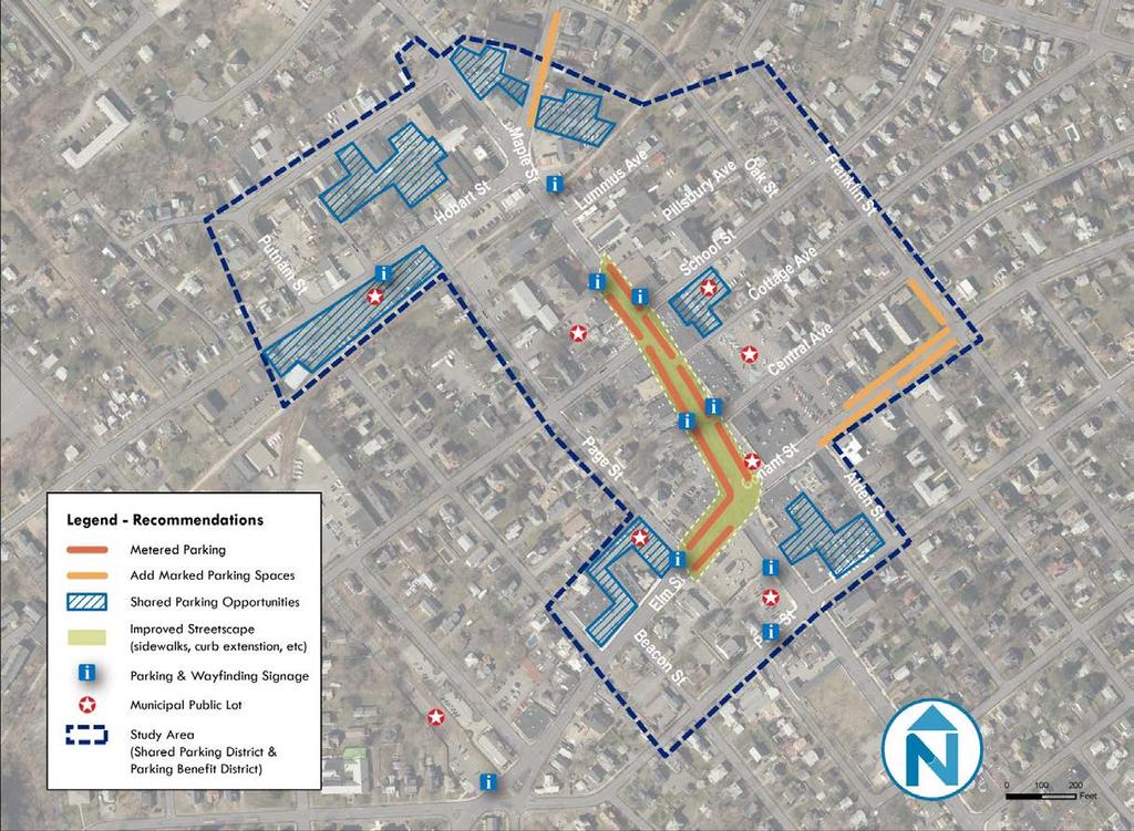
22 PARKING REPORT/Recommendations
 and Poplar Street (Exit 22). Improved/expanded downtown sidewalk network. Extension of the Rail-Trail. Improved MBTA bus service. Wayfinding system.")
23 DOWNTOWN AREA TRAFFIC MANAGEMENT REPORT Downtown Traffic Mitigation Future Mobility Enhancements Other Traffic Mitigation Enhancements to Improve Mobility in Downtown over the Next 20 Years: Improved access to Route 128 at High Street (Exit 23) and Poplar Street (Exit 22). Improved/expanded downtown sidewalk network. Extension of the Rail-Trail. Improved MBTA bus service. Wayfinding system. District-Wide Parking Management Program Downtown living typically includes smaller DUs, fewer vehicle trips, and less need for parking.
24 DOWNTOWN AREA TRAFFIC MANAGEMENT REPORT Other Downtown Traffic Mitigation Trends and Factors Factors and trends that may result in less trips and parking demand over the next 20 years: Growing demand by young professionals and empty nesters to living in downtown as alternative to single-family homes. Downtown provides opportunity for residents to live, work, shop, and play with less need for a car. Growing work-from-home programs (full or parttime) and home-based businesses. On-line shopping services such as Amazon. Car sharing services such as Zip Car. Ride sharing services such as Uber and Lyft. Downtown living typically includes smaller DUs, fewer vehicle trips, and less need for parking.
25 CURRENT ZONING District DOWNTOWN AREA ZONING DISTRICT DIMENSIONAL STANDARDS Use Lots Setbacks Bulk Coverage Min. Lot Size Frontage Front Side Rear Parking Height Stories Max. Lot Coverage C1 - Downtown Core All Uses NA NA 10 (4) 0/5 (5) 0/5 (6) NA 45 3 NA NA NA NA C1A - Downtown Secondary Streets All Uses NA NA 10 (6) 5 (6) 5 (6) 10 (7) 10 (7) NA 35 3 NA NA NA NA 50% I-1 - Maple/Hobart Street Area All Uses NA NA 55 4 Bldg. Coverage NA NA NA I-1 - MSTND 40R Overlay District All Uses Based in Individual Building Type NA Based in Individual Building Type I-1 - Tapleyville Overlay District 10 5 (6) 5 (6) All Uses (10) 25 (7) 25 (7) R-1 - Danvers Sq. Neighborhood NA 45 NA 70% NA 14/Acre 10 (9) Single Family 10, (1) (2) 8 8 NA 30 NA NA NA 1/10,000 NA Two Family 15, (1) (2) 8 8 NA 30 NA NA NA 1/15,000 NA Multi-Family (11) 30, (12) 30 NA NA 1,000/DU 1/7, Dwelling - Conversion 5, NA 8 NA 10 (3) NA NA NA 1/2,500 8 Notes: 1. Eaves, steps, and porches may be less 2. No structure required to be setback more than average of setbacks of existing structures on the street. 3. Side and rear setbacks for aceessory structures not exceeding 120 SF, otherwise principal setbacks apply. 4. Not required to be setback more than the average setback of two abutting and next adjacent los on either side of subject lot feet only where lot shares a common boundary or property line with a residentially zoned lot, otherwise zero feet from another commercially-zoned property. 7. Setback from a residentially zoned property. 8. Height within 10 feet of a residential structure 9. Seperation between building on the same lot. 10. Or the average of the setbacks on same side of the street within 200 feet of the lot, whichever, is less. 11. Multi-Family Dwellings require landscape buffer street of 3 FT around foundation and 10 FT on lot line. 12. From Residential Structure. Open Space Res. Density Bldg Spacing
26 CURRENT ZONING Principal Use DANVERS PARKING REQUIREMENTS VS ITE PEAK DEMAND RATES Danvers Regulation ITE Peak Parking Demand Rates Danvers vs. ITE Residential Institutional Multi-Family residential Assisted Living Nursing Home Elementary School Middle School High School Day Care Church General Office 1 or 2- bedroom unit 2 per Dwelling Unit 1.38 per Dwelling Unit Above More than 2 bedrooms 3 per Dwelling Unit 1.38 per Dwelling Unit Above 0.2 per unit + 1 per employee on largest shift 0.41 per Dwelling Unit per unit + 1 per employee on largest shift 0.35 per Bed per student + 1 space per faculty 0.17 per student Above 0.2 per student + 1 space per faculty 0.09 per student Above 0.33 per student +1 space per faculty 0.23 per student Above 0.1 per student + 1 per employee on largest shift 0.24 per student/ 1.38 per employee Below 0.25 per seat 0.01 per seat Above 4 per 1000 sq ft 2.84 per 1000 sq ft Above Restaurant 0.33 per seat + 1 per employee on largest shift + 1 per 100 sqf function area 0.47 per seat -- Commercial/ Retail Shopping Center Convenience Market 0.33 per seat + 1 per employee on largest shift 0.52 per seat -- 4 per 1000 sq ft 2.55 per 1000 sq ft Above 5 per 1000 sq ft 5.5 per sq ft Below Motor Vehicle Sales 4 per 1000 sq ft + 1 per employee on largest shift 1.78 per 1000 sq ft Above Recreation Hotel/Motel Athletic and Physical Training Facilities Screen Cinema / Theater 1 per room + 1 per employee on largest shift 0.71~0.89 per room Above 2 per 1000 sq ft 3.55 per 1000 sq ft Below 0.25 per seat 0.26 per seat Same Industrial Medical Manufacturing/Light Warehouse / Distribution Hospital Animal Hospital / Kennel / Veterinary Clinic 1 per employee on largest shift, but > 3 per 1000 sq ft 0.67 per employee + 1 per 1000 sq ft per 1000 sq ft for the 2nd 20,000 sq ft + 1 per 4000 sq ft for areas in excess of 40,000 sq ft per employee/ 0.5 per 1,000 sq ft Above 2 per bed 4.49 per bed Below Downtown Danvers Downtown Parking Study Final Report, October 2015, Nelson-Nygaard 0.75~1.02 per 1000 sq ft/ 0.64~0.97 per employee 4 per 1000 sq ft 1.6 per 1000 sq ft Above --
27 CURRENT ZONING SIGN REGULATIONS IN THE DOWNTOWN PROJECT AREA Type of Sign CI and CIA Districts (Not In the DID) Downtown Improvement District (DID) Freestanding Ground Sign Wall Sign Max 15 tall; Max 42 SF; Min 10 Setback Max 1 SF/linear feet of bldg. or 20 SF; 1 sign/bldg.; Max 12 projection off bldg. Max. 1 wall sign per business; Total SF = linear feet o bldg. or 20 SF; Max. 1 sign/bldg.; Max. 12 projection bldg. Second Signs N/A Not permitted Business Directory Sign 1 sign and 1 SF per business 1 sign and 1 SF per business Awning Sign 1 sign and max 20% of surface area Window Sign Max 20% of window space Max 20% of window area Max. 1/awning over window; Max SF = 20% of awning area above display area; Max height of letters/graphic Parking Signs N/A 1 sign/parking lot; Max 3 SF and 4 FT tall Directional Signs N/A Max 1 SF; Number as needed Plaque Signs N/A 2 SF for historic bldgs and cornerstones Dwelling Occupant Sign N/A 1 per unit; Max. 2 SF Roof Sign Not permitted Not permitted Institution Bulletin Board N/A Max.of 2; Max of 12 SF Multi-Tenant Ground Signs 1 ground sign and 1 wall sign per tenant max of 10% of leased SF N/A Sandwich Board Signs Not permitted Not permitted Projecting/Blade Sign Not permitted Not permitted Neon Signs Not permitted Not permitted Light Projection Signs Not permitted Not permitted
UPDATE Board of Selectmen June 20, 2017
 MAPLE STREET I-1 AREA DRAFT ZONING BYLAW & DEVELOPMENT STANDARDS Town of Danvers, MA UPDATE Board of Selectmen June 20, 2017 The Danvers Team: Brovitz Community Planning & Design Dodson & Flinker Danvers
GATEWAY DISTRICTS DRAFT ZONING & DEVELOPMENT STANDARDS City of Portsmouth, NH
 GATEWAY DISTRICTS DRAFT ZONING & DEVELOPMENT STANDARDS City of Portsmouth, NH PLANNING BOARD WORKSHOP June 22, 2017 Brovitz Community Planning & Design HOUSING INITIATIVES Portsmouth 2025 Master Plan (2017)
MAPLE STREET I-1 DISTRICT ZONING CODE & DESIGN STANDARDS DEVELOPMENT Town of Danvers, MA
 MAPLE STREET I-1 DISTRICT ZONING CODE & DESIGN STANDARDS DEVELOPMENT Town of Danvers, MA DRAFT OVERLAY DISTRICT & DESIGN STANDARDS Planning Board Meeting December 13, 2016 The Danvers Team: Brovitz Community
Downtown C1-C1A Project Area Town of Danvers, MA
 PLACEMAKING REPORT PART 1 Downtown C1-C1A Project Area Town of Danvers, MA EXISTING CONDITIONS AND CHARACTERISTICS Prepared by: Brovitz Community Planning & Design with: Dodson & Flinker, Inc. MAY 2018
Chapter DOWNTOWN ZONING DISTRICTS
 Chapter 20.14 Sections: 20.14.010 Purpose of the Downtown Zoning Districts 20.14.020 Land Use Regulations for Downtown Zoning Districts 20.14.030 Development Standards for Downtown Zoning Districts 20.14.010
2.35 BVT G Bow Valley Trail General Commercial District [ ]
![2.35 BVT G Bow Valley Trail General Commercial District [ ]](/thumbs/94/119006025.jpg "2.35 BVT G Bow Valley Trail General Commercial District [ ]") 2.35 BVT G Bow Valley Trail General Commercial District [2014 07] 2.35.1 Purpose This district is intended to form the core of Canmore s visitor accommodation outside the resorts and provide a variety
2.35 BVT G Bow Valley Trail General Commercial District [2014 07] 2.35.1 Purpose This district is intended to form the core of Canmore s visitor accommodation outside the resorts and provide a variety
CAN TRADITIONAL ZONING ACHIEVE OUR GOALS FOR DOWNTOWN ANN ARBOR?
 TRADITIONAL ZONING TRADITIONAL ZONING CAN TRADITIONAL ZONING ACHIEVE OUR GOALS FOR DOWNTOWN ANN ARBOR? A dense, mixed use core with flexible land uses A range of housing types and costs A walkable, pedestrian-oriented
City Avenue District Rezoning. Regional Center Area & Bala Cynwyd Retail District December 14, 2011 Public Hearing
 City Avenue District Rezoning Regional Center Area & Bala Cynwyd Retail District December 14, 2011 Public Hearing Board of Commissioners Agenda Public Hearings An Ordinance to create The City Avenue District,
PEDESTRIAN OVERLAY DISTRICT. November 6, 2013 Charlotte-Mecklenburg Planning Department
 Midtown Morehead Cherry PEDESTRIAN OVERLAY DISTRICT November 6, 2013 Charlotte-Mecklenburg Planning Department Meeting Purpose To provide a background on the Pedestrian Overlay District Zoning text amendment
From Policy to Reality
 From Policy to Reality Updated ^ Model Ordinances for Sustainable Development 2000 Environmental Quality Board 2008 Minnesota Pollution Control Agency Funded by a Minnesota Pollution Control Agency Sustainable
ATTACHMENT C. Development Requirements
 ATTACHMENT C Development Requirements Development Codes, also known as Municipal Codes, were reviewed for each station and compiled by jurisdiction. Only those zoning designations located within 0.5 mile
Town of Cary, North Carolina Rezoning Staff Report 12-REZ-27 Morris Branch Town Council Public Hearing January 24, 2013
 Town of Cary, North Carolina Rezoning Staff Report 12-REZ-27 Morris Branch Town Council Public Hearing January 24, 2013 REQUEST To amend the Town of Cary Official Zoning Map to rezone approximately 9.0
Suburban Commercial Center ( CE-S ) Permitted Principal Uses and Structures
 Permitted Principal Uses and Structures") Division 12. Suburban Commercial Center ( CE-S ) 2.9.1 Purpose Suburban commercial centers provide regional commercial destinations with design and site elements compatible with suburban character. Dimensional
Division 12. Suburban Commercial Center ( CE-S ) 2.9.1 Purpose Suburban commercial centers provide regional commercial destinations with design and site elements compatible with suburban character. Dimensional
ARTICLE 10 SPECIAL PURPOSE DISTRICTS
 ARTICLE 10 SPECIAL PURPOSE DISTRICTS Sec. 29.1000. SPECIAL PURPOSE DISTRICTS. (1) Purpose. Each Special Purpose District will appear on the City's Zoning Map as a Base Zone. The Special Purpose Districts
Puyallup Downtown Planned Action & Code Changes. January 10, 2017
 Puyallup Downtown Planned Action & Code Changes January 10, 2017 Purpose & Location Purpose Promote economic development and downtown revitalization Tools: Municipal Code amendments Change development
Town of Clinton, Connecticut Action Plan for the Historic Unilever Property and Area. Steering Committee Meeting #5 Implementation Strategies
 Town of Clinton, Connecticut Action Plan for the Historic Unilever Property and Area Steering Committee Meeting #5 Implementation Strategies Wednesday, March 19, 2014 6:30pm Steering Committee Meeting
!( 22 !( 115 !( 168. Zoning Districts Map. City of Frankfort. City of Frankfort. Zoning Ordinance. Lake Michigan. Lake Betsie
 4th St \\dtdata\projects\frk2002\01d\gis-data\projects\zoning Map Rev Apr 2017.mxd George St Crystal Lake Twp. City of Frankfort Denton Ave Beech St Bellows Ave Day Ave Lake Michigan Michigan Ave Winnebago
CITY OF SARATOGA SPRINGS ZONING ORDINANCE TABLE 1: 2.0 BASE ZONING DISTRICTS
 2.0 BASE S 2.1 INTENT To fulfill the intent and purpose of this Chapter, the following tables identify zoning districts and district intents (Table 1), districts use schedule (Table 2), and districts area
Article Optional Method Requirements
 Article 59-6. Optional Method Requirements [DIV. 6.1. MPDU DEVELOPMENT IN RURAL RESIDENTIAL AND RESIDENTIAL ZONES Sec. 6.1.1. General Requirements... 6 2 Sec. 6.1.2. General Site and Building Type Mix...
LOT AREA AND FRONTAGE
 LOT AREA AND FRONTAGE Lot Area & Frontage for the R2.1 Zone Lot Area & Frontage for the R2.4 Zone Minimum Lot Minimum Lot Zone Area Width R2.1 700 sq m 18 m R2.4 600 sq m 16 m Lot Area means the total
Parking Challenges and Trade-Offs
 Parking Challenges and Trade-Offs What is the best way to balance competing interests and priorities while updating the City s off street parking regulations? Updating off street parking regulations can
Community Advisory Committee (CAC) Meeting #7 West Anaheim Youth Center May 26, 2016
 Meeting #7 West Anaheim Youth Center May 26, 2016") Community Advisory Committee (CAC) Meeting #7 West Anaheim Youth Center May 26, 2016 1 Project Team City: David Belmer Planning and Building Director Jonathan Borrego, AICP Planning Services Manager Gustavo
Community Advisory Committee (CAC) Meeting #7 West Anaheim Youth Center May 26, 2016 1 Project Team City: David Belmer Planning and Building Director Jonathan Borrego, AICP Planning Services Manager Gustavo
RT-5 and RT-5N Districts Schedule
 Districts Schedule 1 Intent The intent of this District Schedule is to strongly encourage the retention and renovation of existing character houses by providing incentives such as increased floor area,
Town of Danvers Planning Board
 Town of Danvers Planning Board Danvers Town Hall One Sylvan Street Danvers, MA 01923 www.danvers.govoffice.com Margaret Zilinsky, Chair Kristine Cheetham William Prentiss Aaron Henry James Sears John Farmer,
ARTICLE VI BUSINESS DISTRICTS
 ARTICLE VI BUSINESS DISTRICTS 6.1 BUSINESS DISTRICT PURPOSE STATEMENTS 1. Purpose of B1-T Downtown Transition Overlay District The purpose of the B1-T Downtown Transition Overlay District is to provide
CHAPTER 6 Low Density Residential Zoning Districts
 CHATER 6 Low Density Residential Zoning Districts Section 6.1 Description and urpose: This Chapter presents the regulations of two Zoning Districts: the RL-14 Single Family Residential and the RL-10 Residential.
Chapter URBAN VILLAGE ZONING DISTRICTS
 Chapter 20.16 Sections: 20.16.010 Purpose of the Urban Village Zoning Districts 20.16.020 Land Use Regulations for the Urban Village Zoning Districts 20.16.030 Development Standards & Guidelines for the
MONROE WARD REZONING SUMMARY. October 2018
 MONROE WARD REZONING SUMMARY October 2018 WHY IS THE CITY REZONING MONROE WARD? In July of 2017 Richmond City Council adopted The Pulse Corridor Plan, a corridor-long planning document that outlines steps
ARTICLE 5. COMMERCIAL AND OFFICE DISTRICTS 5.1 PURPOSE STATEMENTS 5.2 USES 5.3 DIMENSIONAL STANDARDS 5.4 DESIGN STANDARDS 5.5 DK DISTRICT STANDARDS 5
 ARTICLE 5. COMMERCIAL AND OFFICE DISTRICTS 5.1 PURPOSE STATEMENTS 5.2 USES 5.3 DIMENSIONAL STANDARDS 5.4 DESIGN STANDARDS 5.5 DK DISTRICT STANDARDS 5.6 CU DISTRICT STANDARDS 5.7 SW DISTRICT STANDARDS THE
VERTICAL MIXED USE DEVELOPMENT (Urban Village)
") VERTICAL MIXED USE DEVELOPMENT (Urban Village) Overall Goal Statement Vertical Mixed Use (Urban Villages) have similar goals to Horizontal Mixed Use except densities are usually higher and projects frequently
VERTICAL MIXED USE DEVELOPMENT (Urban Village) Overall Goal Statement Vertical Mixed Use (Urban Villages) have similar goals to Horizontal Mixed Use except densities are usually higher and projects frequently
Table of Contents ARTICLE 5A CHARACTER-BASED ZONING 1
 Table of Contents ARTICLE 5A CHARACTER-BASED ZONING 1 SECTION 10.5A10 GENERAL... 1 10.5A11 Purpose and Intent... 1 10.5A12 Applicability... 1 10.5A13 Compliance with Regulating Plan... 1 10.5A14 Relationship
Subchapter 5 Zoning Districts and Limitations
 Subchapter 5 Zoning Districts and Limitations 35.5.1 Rural Districts Sections: 35.5.1.1 Purpose. 35.5.1.2 Permitted Uses. 35.5.1.3 General Regulations. 35.5.1.1 Purpose. The purpose of a Rural District
Wilson Bridge Corridor Zoning. Department of Planning & Building
 Wilson Bridge Corridor Zoning Department of Planning & Building Background: Wilson Bridge Road Corridor Study The City conducted a strategic study of one of the community s primary economic centers, the
TH STREET NW
 10th Street NW 227-301 2nd Avenue NW CTrain LOC 2012-0069 / CPC 2013-036 227 303 10 TH STREET NW Located at 10 th Street & 2 nd Avenue NW T intersection Location within policy areas: Within the Transit
PLANNING COMMISSION. Study Session: Beach Boulevard Specific Plan Workshop
 PLANNING COMMISSION Study Session: Beach Boulevard Specific Plan Workshop Project Background Sustainable Communities Grant Funding Phase 1 Outreach: Improve the Boulevard A Specific Plan is a long-term
Table of Contents ARTICLE 5A CHARACTER-BASED ZONING 1
 Table of Contents ARTICLE 5A CHARACTER-BASED ZONING 1 SECTION 10.5A10 GENERAL... 1 10.5A11 Purpose and Intent... 1 10.5A12 Applicability... 1 10.5A13 Compliance with Regulating Plan... 1 10.5A14 Relationship
SPRINGBANK SIX CORNERS, LLC
 SITE ADDRESS: 305 NORTH SOUTHPORT 356 WEST WELLINGTON ZONING DISTRICT: B3-2 (CURRENT) B3-2 (CURRENT) PROPOSED ZONING DISTRICT: B2-3 B2-3 PROPOSED USE: RESIDENTIAL RETAIL / ASSEMBLY / RESIDENTIAL F.A.R.:
Permitted uses. Adult congregate living facility. Ambulance service. Animal clinics (outpatient care only and no overnight boarding)
") B-3, HIGHWAY SERVICE BUSINESS DISTRICT Intent. The B-3, Highway Service Business District is intended for application along highways carrying large volumes of traffic where establishments may locate to
B-3, HIGHWAY SERVICE BUSINESS DISTRICT Intent. The B-3, Highway Service Business District is intended for application along highways carrying large volumes of traffic where establishments may locate to
RT-6 District Schedule
 District Schedule 1 Intent The intent of this Schedule is to encourage the retention, renovation and restoration of existing residential buildings which maintain the historic architectural style and building
DAVIDSON PLANNING ORDINANCE AMENDMENTS AFTER SEPTEMBER 2009 SECTION 9
 AMENDMENT ADOPTED 6/12/2012 Section 9.1.3.3.1 Wall Murals Entire Section Added: 9.1.3.3.1 Wall Murals DAVIDSON PLANNING ORDINANCE AMENDMENTS AFTER SEPTEMBER 2009 SECTION 9 Exterior wall murals are only
Composition of traditional residential corridors.
 Page 1 of 7 St. Petersburg, Florida, Code of Ordinances >> PART II - ST. PETERSBURG CITY CODE >> Chapter 16 - LAND DEVELOPMENT REGULATIONS >> SECTION 16.20.060. CORRIDOR RESIDENTIAL TRADITIONAL DISTRICTS
2015 Downtown Parking Study
 2015 Downtown Parking Study City of Linden Genesee County, Michigan November 2015 Prepared by: City of Linden Downtown Development Authority 132 E. Broad Street Linden, MI 48451 www.lindenmi.us Table of
Berry/University Form Based Code and Urban Residential Development
 Berry/University Form Based Code and Urban Residential Development Presented to the City Council by the Planning and Development Department October 11, 2016 Purpose Review proposed Berry/University formbased
RT-8 District Schedule
 District Schedule 1 Intent The intent of this Schedule is to encourage the retention and renovation of existing buildings which maintain an architectural style and building form consistent with the historical
Article 3. SUBURBAN (S-) NEIGHBORHOOD CONTEXT
 NEIGHBORHOOD CONTEXT") Article 3. SUBURBAN (S-) NEIGHBORHOOD CONTEXT this page left intentionally blank Contents ARTICLE 3. SUBURBAN (S-) NEIGHBORHOOD CONTEXT DIVISION 3.1 NEIGHBORHOOD CONTEXT DESCRIPTION...3.1-1 Section 3.1.1
Article 3. SUBURBAN (S-) NEIGHBORHOOD CONTEXT this page left intentionally blank Contents ARTICLE 3. SUBURBAN (S-) NEIGHBORHOOD CONTEXT DIVISION 3.1 NEIGHBORHOOD CONTEXT DESCRIPTION...3.1-1 Section 3.1.1
Broadway Corridor Woodcliff Lake, NJ
 Broadway Corridor Woodcliff Lake, NJ December 5 th, 2016 History 1985 Master Plan 1995 Re examination Study 2002 Master Plan Update Identifies need to improve Broadway Corridor 2008 Broadway Corridor Study
City of Coral Gables Planning and Zoning Staff Report
 City of Coral Gables Planning and Zoning Staff Report Applicant: Application: Public Hearing: Date & Time: Location: City of Coral Gables Zoning Code Text Amendment Giralda Plaza Overlay District Planning
for lots created after Nov. 10, 2004
 Renton Municipal Code 4-2-120A Page 1 of 7 4-2-120A DEVELOPMENT STANDARDS FOR COMMERCIAL ZONING DESIGNATIONS LOT DIMENSIONS CN CV CA Minimum Lot Size 5,000 sq. ft. 25,000 sq. ft. 5,000 sq. ft. for lots
EXHIBIT 1 PROJECT DESCRIPTION AND DESCRIPTION OF REQUESTED AREA VARIANCES REDEVELOPMENT OF 201 ELLICOTT STREET
 EXHIBIT 1 PROJECT DESCRIPTION AND DESCRIPTION OF REQUESTED AREA VARIANCES REDEVELOPMENT OF 201 ELLICOTT STREET I. PROJECT DESCRIPTION: Ciminelli Real Estate Corporation (the Applicant ) is seeking area
Church Street and 117 Dundas Street East - Zoning Amendment Application - Preliminary Report
 STAFF REPORT ACTION REQUIRED 215-229 Church Street and 117 Dundas Street East - Zoning Amendment Application - Preliminary Report Date: February 26, 2015 To: From: Wards: Reference Number: Toronto and
2.110 COMMERICAL MIXED USE (CM)
") CITY OF KEIZER DEVELOPMENT BULLETIN 2.110.01 Purpose 2.110 COMMERICAL MIXED USE (CM) The Commercial Mixed Use (CM) zone is the primary commercial zone within the City. The zone is specifically designed
CITY OF KEIZER DEVELOPMENT BULLETIN 2.110.01 Purpose 2.110 COMMERICAL MIXED USE (CM) The Commercial Mixed Use (CM) zone is the primary commercial zone within the City. The zone is specifically designed
DEVELOPMENT STANDARDS FOR RESIDENTIAL PROJECTS RESIDENTIAL BUILDING TYPES: APPROPRIATE ZONES AND DENSITIES 2-1
 2 DEVELOPMENT STANDARDS FOR RESIDENTIAL PROJECTS RESIDENTIAL BUILDING TYPES: APPROPRIATE ZONES AND DENSITIES 2-1 This Chapter presents the development standards for residential projects. Section 2.1 discusses
Overview. Central Street Master Plan. Appendix B: Zoning
 Central Street Master Plan Overview The City of Evanston has 36 zoning districts, of which 11 are found in the Central Street Corridor Study Area (See Figures B.1 and B.2). They include: R1: Single-Family
Coding For Places People Love Main Street Corridor District
 Coding For Places People Love Main Street Corridor District 1) Scope a) District boundaries are assigned according to the District Boundary Map. b) The Primary Retail Corridor is assigned according to
RT-7 District Schedule
 District Schedule 1 Intent The intent this Schedule is to encourage the retention and renovation of existing buildings which maintain an architectural style and building form consistent with the historical
UDO Advisory Committee Meeting #3 August 18, 2011
 UDO Advisory Committee Meeting #3 August 18, 2011 Today s s Agenda Welcome Recap of Meeting #2 Overview of Strategy Statement Overview of Zoning Districts What changes and what stays the same? Break Putting
ARTICLE OPTIONAL METHOD REGULATIONS
 ARTICLE 59-6. OPTIONAL METHOD REGULATIONS DIV. 6.1. MPDU DEVELOPMENT IN RURAL RESIDENTIAL AND RESIDENTIAL ZONES SEC. 6.1.1. GENERAL REQUIREMENTS... 6 2 SEC. 6.1.2. GENERAL SITE AND BUILDING T PE MIX...
Pentagon Centre (SP#297) PDSP & Phase I Site Plan Amendments SPRC #1
 PDSP & Phase I Site Plan Amendments SPRC #1") Pentagon Centre (SP#297) PDSP & Phase I Site Plan Amendments SPRC #1 CPHD February 23, 2015 Meeting Agenda Background on relevant planning context, guidance, and County policy Brief update on original
Pentagon Centre (SP#297) PDSP & Phase I Site Plan Amendments SPRC #1 CPHD February 23, 2015 Meeting Agenda Background on relevant planning context, guidance, and County policy Brief update on original
SECTION CORRIDOR DISTRICTS
 4.0401 Purpose SECTION 4.0400 CORRIDOR DISTRICTS General Corridor District Characteristics 4.0410 Rockwood Town Center (RTC) 4.0411 Station Centers (SC) 4.0412 Corridor Multi-Family (CMF) 4.0413 Corridor
SECTION CLASSIFICATION OF ZONES For the purpose of this Code the following primary land use zoning districts are hereby established:
 ARTICLE 4 ZONING DISTRICTS SECTION 4.010 CLASSIFICATION OF ZONES For the purpose of this Code the following primary land use zoning districts are hereby established: Primary Zones Abbreviated Designation
EIA Model Test 7: R-O to R-O
 1 SUPPLEMENTARY MODEL: DETERMINING LARGEST BUILDING POSSIBLE 2 Name of Project: Park Plaza II Apartment Homes Current Code R-O Proposed Code R-O 3 Project Development Category (drop down menu, select one)
Zoning Project Objectives
 Zoning Project Objectives Help implement comprehensive plan, character area update and other city policies Update and modernize Make regulations clear, easy to use and understand Scope Zoning districts
The summary of zoning regulations for each site is provided in the same order (and using the same names for each site) as the RFEI.
 as the RFEI.") Lincoln City Zoning/regulatory Overview This paper provides a summary of zoning regulations for the eight properties included in Lincoln City s Request for Expressions of Interest (RFEI). The complete
Lincoln City Zoning/regulatory Overview This paper provides a summary of zoning regulations for the eight properties included in Lincoln City s Request for Expressions of Interest (RFEI). The complete
Town of Windham Land Use Ordinance Sec. 400 Zoning Districts SECTION 400 ZONING DISTRICTS
 Town of Windham Land Use Ordinance Sec. 400 Zoning Districts Sections SECTION 400 ZONING DISTRICTS SECTION 400 ZONING DISTRICTS 4-1 401 Districts Enumerated 4-2 402 Location of districts; Zoning Map 4-2
Article 04 Single Family Residential Districts
 Article 04 Article 04 Section 04.01 Intent (a) R1A Residence District. The R1A Single Family Residential District is established to include areas of low density single-family residences and limited agricultural
TOWN OF DANVERS HIGH STREET INDUSTRIAL 1 (I-1) DISTRICT STUDY DRAFT FINAL REPORT DRAFT FOR DISCUSSION - 03/16/18
 DISTRICT STUDY DRAFT FINAL REPORT DRAFT FOR DISCUSSION - 03/16/18") TOWN OF DANVERS HIGH STREET INDUSTRIAL 1 (I-1) DISTRICT STUDY DRAFT FINAL REPORT DRAFT FOR DISCUSSION - 03/16/18 TOWN OF DANVERS HIGH STREET INDUSTRIAL 1 (I-1) DISTRICT STUDY Funding for this study was
TOWN OF DANVERS HIGH STREET INDUSTRIAL 1 (I-1) DISTRICT STUDY DRAFT FINAL REPORT DRAFT FOR DISCUSSION - 03/16/18 TOWN OF DANVERS HIGH STREET INDUSTRIAL 1 (I-1) DISTRICT STUDY Funding for this study was
Chapter 8 The Residential District Requirements
 Chapter 8 The Residential District Requirements ECTION: 9-8-1 General Purpose tatement 9-8-2 General Cross-reference Guide for Additional Regulations. 9-8-3 Residential District Regulations 9-8-4 E-1 Estate
Town of Cary, North Carolina Rezoning Staff Report 14-REZ-20 Habitat for Humanity Evans Road Town Council Meeting October 16, 2014
 Town of Cary, North Carolina Rezoning Staff Report 14-REZ-20 Habitat for Humanity Evans Road Town Council Meeting October 16, 2014 REQUEST To amend the Town of Cary Official Zoning Map by rezoning 0.53
Farming & Livestock related activities Y Y Y Y Y Y. Commercial Type Animal Facility Y Y Y
 ( = Permitted) TABLE A PERMITTED USES B DISTRICT MU MU2 CC MH/ RV Agricultural Uses (Light) Agricultural Uses (Heavy) Residential Uses Recreational and Institutional Uses RM R C LI MI HI A Farming & Livestock
4.2 RESIDENTIAL ZONING DISTRICTS
 4.2 RESIDENTIAL ZONING DISTRICTS A. Purpose: To define regulations and standards for each residential zoning district in the City. The following sections identify uses, regulations, and performance standards
City Avenue District Rezoning
 November 16, 2011 Lower Merion Township Building & Planning Committee City Avenue District Rezoning Regional Center Area & Bala Cynwyd Retail District November 16, 2011 Building & Planning Committee Building
Land Use and Zoning Changes for Land Development Code Update
 Land Use and Zoning Changes for Land Development Code Update T2 T3 T-4 M: Urban Mixed-Use Zoning District Urban Mixed Use Land Use (Renamed T-4 M2) March 26, 2014 T4 T5 T6 OVERVIEW Purpose of the workshop
RM-8 and RM-8N Districts Schedule
 Districts Schedule 1 Intent The intent of this schedule is to encourage development of ground-oriented stacked townhouses or rowhouses, including courtyard rowhouses, while continuing to permit lower intensity
PLANNED DEVELOPMENT DISTRICT STANDARDS. Cadence Site
 PLANNED DEVELOPMENT DISTRICT STANDARDS Cadence Site A Planned Development District 1. Statement of General Facts, Conditions and Objectives Property Size: Approximately 57.51 Acres York County Tax Map
Appendix1,Page1. Urban Design Guidelines. Back to Back and Stacked Townhouses. DRAFT September 2017
 Appendix1,Page1 Urban Design Guidelines DRAFT September 2017 Back to Back and Stacked Townhouses Appendix1,Page2 Table of Contents 1 Introduction 1 1.1 Purpose 1 1.2 Urban Design Objectives 1 1.3 Building
SALT LAKE CITY ORDINANCE No. of 2016
 SALT LAKE CITY ORDINANCE No. of 2016 (Amending the Sugar House Master Plan, amending the zoning ordinance to create the SC and SE Form Based Special Purpose Corridor districts, and amending the zoning
Missing Middle Housing in Practice
 Missing Middle Housing in Practice Daniel Parolek Principal, Opticos Design, Inc. dan@opticosdesign.com New Partners for Smart Growth Kansas City, MO 2013 1 Bungalow Courts Missing MIddle Housing 2012
MAPLE STREET I-1 DISTRICT PROJECT AREA PLACEMAKING AUDIT
 MAPLE STREET I-1 DISTRICT PROJECT AREA PLACEMAKING AUDIT EXISTING CONDITIONS I CHALLENGES I OPPORTUNITIES FINAL REPORT November 2016 Brovitz Community Planning & Design with Dodson & Flinker Associates
66 Isabella Street Rezoning Application - Preliminary Report
 STAFF REPORT ACTION REQUIRED 66 Isabella Street Rezoning Application - Preliminary Report Date: November 15, 2010 To: From: Wards: Reference Number: Toronto and East York Community Council Director, Community
David J. Gellner, AICP, Principal Planner, ,
 Staff Report PLANNING DIVISION COMMUNITY & ECONOMIC DEVELOPMENT To: From: Salt Lake City Planning Commission David J. Gellner, AICP, Principal Planner, 801-535-6107, david.gellner@slcgov.com Date: March
Goal 1 - Retain and enhance Cherry Creek North s unique physical character.
 Introduction This document summarizes the proposed new zoning for the area of roughly bordered by University Boulevard, Steele Street, 3rd Avenue, and 1st Avenue. It provides a high-level review of the
RECOMMENDED ACTION: Council may vote to make specific changes to the draft. Staff will be available to help in guiding specific motions.
 CITY COUNCIL Agenda Item #16-164. Date: June 8, 2016 Consent Discussion _x_ SUBJECT: Presentation of Part 2 Unified Development Bylaws SUBMITTING DEPARTMENT: Planning RECOMMENDED ACTION: Council may vote
Sec For the purpose of this Ordinance, the City of Plainwell is hereby divided into the following districts: TABLE INSET:
 15.030 Districts. Sec. 300. For the purpose of this Ordinance, the City of Plainwell is hereby divided into the following districts: TABLE INSET: 1. R-1A, R-1B Single-Family Residence District 2. R-1C
Yonge Street and 3 Gerrard Street East - Zoning Amendment Application - Preliminary Report
 STAFF REPORT ACTION REQUIRED 363-391 Yonge Street and 3 Gerrard Street East - Zoning Amendment Application - Preliminary Report Date: May 22, 2015 To: From: Wards: Reference Number: Toronto and East York
Community Development
 Community Development STAFF REPORT Housing Commission Meeting Date: 7/11/2018 Staff Report Number: 18-013-HC Regular Business: Review and provide feedback on potential amendments to the El Camino /Downtown
MAPLE STREET I-1 DISTRICT AREA ZONING BYLAW
 MAPLE STREET I-1 DISTRICT AREA ZONING BYLAW SECTION 18 MAPLE STREET TRADITIONAL NEIGHBORHOOD DEVELOPMENT OVERLAY DISTRICT (CHAPTER 40R SMART GROWTH OVERLAY DISTRICT) VERSION 4.0 October 31, 2017 Brovitz
City of Chico Title 19 Land Use & Development Regulations TND Zone
 City of Chico Title 19 Land Use & Development Regulations TND Zone Adopted by the City of Chico July 3, 2002 (Ordinance #2358) TITLE 19 LAND USE AND DEVELOPMENT REGULATIONS TABLE OF CONTENTS DIVISION VI.
Fountain District Urban Village
 Fountain District Urban Village Planning Commission Work Session June 3, 2010 City of Bellingham, Washington Planning & Community Development Department 1 Fountain District Urban Village Planning City
COMMERCIAL AND MIXED USE zones COMMERCIAL AND MIXED USE ZONES. Zoning By-law PLANNING & ECONOMIC DEVELOPMENT PLANNING DEPARTMENT DIVISION
 Zoning By-law 05-200 COMMERCIAL AND MIXED USE zones PLANNING & ECONOMIC DEVELOPMENT PLANNING DEPARTMENT DIVISION CONTENTS CONTEXT... 1 URBAN HAMILTON OFFICIAL PLAN... 2 COMMERCIAL AND MIXED USE ZONES...
Chapter MIXED USE ZONING DISTRICTS
 Page 1 of 12 Page 1/12 Chapter 17.18 MIXED USE ZONING DISTRICTS Sections: 17.18.010 Purposes. 17.18.020 Permitted, conditional and prohibited uses. 17.18.030 Bulk, 17.18.010 Purposes. A. Mixed Use Districts.
CHAPTER COMMERCIAL AND INDUSTRIAL ZONING DISTRICTS
 Commercial and Industrial Zoning Districts 106.26.010 CHAPTER 106.26 - COMMERCIAL AND INDUSTRIAL ZONING DISTRICTS COMMERCIAL AND INDUSTRIAL ZONING DISTRICTS Sections: 106.26.010 - Purpose 106.26.020 -
TOWNHOUSE. TYPICAL UNIT SIZE 1,200 to 1,600 square foot average unit (two to three stories) DENSITY dwelling units/acre without cottages
 DENSITY dwelling units/acre without cottages") TOWNHOUSE Townhouses are typically two to three stories in height. Some townhouses include separate rental units, either on the top or bottom floor of a three-story townhouse unit, or in a cottage above
TOWNHOUSE Townhouses are typically two to three stories in height. Some townhouses include separate rental units, either on the top or bottom floor of a three-story townhouse unit, or in a cottage above
PART 3 RESIDENTIAL ZONING DISTRICTS. Designation of Residential Zoning Districts and Purpose Statements.
 PART 3 S Section 301. Designation of and Purpose Statements. See Table 3-1 herein this Section for the designations and purpose statements of the respective Residential Zoning Districts which are shown
GAINES CHARTER TOWNSHIP KENT COUTNY, MICHIGAN ORDINANCE NO TB. CHAPTER 6 Low Density Residential Zoning Districts
 GAINES CHARTER TOWNSHIP KENT COUTNY, MICHIGAN ORDINANCE NO. 15-05-TB An ordinance authorizing changes to Chapter 6 Low Density Residential Zoning Districts, of the Gaines Charter Township Zoning Ordinance.
CHAPTER 6 RESIDENTIAL DISTRICTS LOW DENSITY RESIDENTIAL DISTRICT (R-1)
") TYPE OF DISTRICT: TRADITIONAL CHAPTER 6 RESIDENTIAL DISTRICTS LOW DENSITY RESIDENTIAL DISTRICT (R-1) ARTICLE 1: LOW DENSITY RESIDENTIAL DISTRICT (R-1) SECTION 6-1.01: PURPOSE The regulations of the R-1
TYPE OF DISTRICT: TRADITIONAL CHAPTER 6 RESIDENTIAL DISTRICTS LOW DENSITY RESIDENTIAL DISTRICT (R-1) ARTICLE 1: LOW DENSITY RESIDENTIAL DISTRICT (R-1) SECTION 6-1.01: PURPOSE The regulations of the R-1
Attachment 5 - Ordinance 3154 Exhibit D (Revised for 9/15 Council Meeting) Page 1 of 7 Port Townsend Municipal Code. Chapter 17.18
 Page 1 of 7 Port Townsend Municipal Code. Chapter 17.18") Page 1 of 7 Page 1/7 Chapter 17.18 MIXED USE ZONING DISTRICTS Sections: 17.18.010 Purposes. 17.18.020 Permitted, conditional and prohibited uses. 17.18.030 Bulk, 17.18.010 Purposes. A. Mixed Use Districts.
Page 1 of 7 Page 1/7 Chapter 17.18 MIXED USE ZONING DISTRICTS Sections: 17.18.010 Purposes. 17.18.020 Permitted, conditional and prohibited uses. 17.18.030 Bulk, 17.18.010 Purposes. A. Mixed Use Districts.
Downtown Development Focus Area: I. Existing Conditions
 Downtown Development Focus Area: I. Existing Conditions The Downtown Development Focus Area is situated along Route 1, south of the train tracks, except for the existing Unilever property. It extends west
DRAFT FOR DISCUSSION PURPOSES ONLY. Port Credit Local Area Plan Built Form Guidelines and Standards DRAFT For Discussion Purposes
 Port Credit Local Area Plan Built Form Guidelines and Standards DRAFT For Discussion Purposes 1 Local Area Plan - Project Alignment Overview Directions Report, October 2008 (General Summary Of Selected
9.3 Downtown Commercial (CDT1, CDT2, CDT3)
") 9.3 Downtown Commercial (CDT1, CDT2, CDT3) 9.3.1 Purpose The zone provides for a broad range of commercial, service, business, entertainment and residential needs typical of a City Centre. The zone is
9.3 Downtown Commercial (CDT1, CDT2, CDT3) 9.3.1 Purpose The zone provides for a broad range of commercial, service, business, entertainment and residential needs typical of a City Centre. The zone is
DEVELOPMENT DEPARTMENT STAFF REPORT STAFF REPORT EASTSIDE CHAMBLEE LINK DCI
 DEVELOPMENT DEPARTMENT STAFF REPORT Public Hearing Date: April 12, 2018 Item #: PZ-2018-248 STAFF REPORT EASTSIDE CHAMBLEE LINK DCI Request: Development of Community Compact (DCI), ten concurrent variances,