SALT LAKE CITY ORDINANCE No. of 2016
|
|
|
- Owen Day
- 5 years ago
- Views:
Transcription
1 SALT LAKE CITY ORDINANCE No. of 2016 (Amending the Sugar House Master Plan, amending the zoning ordinance to create the SC and SE Form Based Special Purpose Corridor districts, and amending the zoning map to apply SC and SE Form Based Special Purpose Corridor zoning districts) An ordinance amending the Sugar House Master Plan, amending the zoning ordinance to create the SC and SE Form Based Special Purpose Corridor zoning districts, and amending the zoning map to establish SC and SE Form Based Special Purpose Corridor zoning districts pursuant to Petition Nos. PLNPCM and PLNPCM WHEREAS, the Salt Lake City Planning Commission held public hearings on May 22, 2013 and July 10, 2013 on applications submitted by the Salt Lake City Mayor ( Applicant ) to amend the Sugar House Master Plan (PLNPCM ), and to amend the zoning ordinance and zoning map to create and apply the SC and SE Form Based Special Purpose Corridor zoning districts (PLNPCM ); and WHEREAS, at its July 31, 2013 meeting, the planning commission voted in favor of forwarding a positive recommendation to the Salt Lake City Council on said applications; and WHEREAS, after a public hearing on this matter the city council has determined that adopting this ordinance is in the city s best interests; and NOW, THEREFORE, be it ordained by the City Council of Salt Lake City, Utah: SECTION 1. Amending the Sugar House Master Plan. That the Sugar House Master Plan shall be and hereby is amended as follows: a. Amending the Text of the Sugar House Master Plan. That the text of the Sugar House Master Plan, as adopted in 2001 and subsequently amended, shall be and hereby is amended to add the Community Transit District land use category to the Sugar House Development
2 Objectives subsection of the Sugar House Future Land Use Plan section of that master plan, which appears on Page 2 thereof. The following text shall be inserted on Page 2 of the master plan following the High-Intensity Mixed Use category paragraph: Community Transit District The Community Transit District supports the development of a localized urban center that capitalizes on close proximity to the Sugar House Streetcar corridor and arterial streets. Uses include a mix of residential, retail, commercial, and office with buildings oriented to the pedestrian environment. Building height and density is concentrated along arterial streets and is similar to the height, density, and design in the Sugar House Business District which would create two active destinations linked by transit. While being a high density area, development in the Community Transit District also respects and is compatible with the surrounding residential neighborhoods. Future public improvements should be focused on creating an interconnected and cohesive district that caters to all modes of transportation including pedestrians and cyclists. b. Amending the Text of the Sugar House Master Plan. That the text of the Sugar House Master Plan shall be and hereby is amended to add the following language to the Mobility, Access & the Pedestrian Experience section of the master plan (to be inserted at the end of that section): Sugar House Streetcar and Greenway Corridor The Sugar House community has long envisioned the transformation of the Denver Rio Grande rail right-of-way into a public transit and multi-use trail corridor. In 2012, this vision came to fruition as construction began on the Sugar House Streetcar and Greenway, a two mile long transit and active transportation corridor that connects the Sugar House Business District with the north-south TRAX light rail line at 2100 South in South Salt Lake City. In 2011, the Redevelopment Agency of Salt Lake City funded an effort to create a vision for the streetcar corridor and surrounding area. This resulted in a set of recommendations put into a report titled Sugar House Streetcar Land Use and Urban Design Recommendations. As a result of this process, the City of Salt Lake City has funded improvements to transform the streetcar corridor into a greenway that includes dedicated multi-use pathways and amenities. Many of the recommendations stated in the Land Use and Urban Design Recommendations report that are related to the streetcar and greenway corridor itself have been implemented. There are still improvements that should be considered in 2
3 the future to activate the corridor, support existing neighborhoods, and create vibrant transit oriented districts near the streetcar stops. Policies Work with Utah Transit Authority (UTA) to add a neighborhood serving streetcar stop near 800 East. Where easements exist for automobile access within the corridor, the City should work with property owners to eliminate the easements. In the event of redevelopment of a property with an automobile access easement, all options must be explored to relocate and remove automobile access from the corridor. Restore the original rail line right-of-way boundaries by removing existing encroachments (structures, fences, parking, etc.). Streets that cross the corridor (500 East, 600 East, 700 East, 800 East, and 900 East) connect the corridor to adjacent neighborhoods; therefore, they should be developed as complete streets where feasible. Development along the streetcar and greenway should encourage transit and trail usage, and provide eyes on the corridor. All buildings should have entrances from the corridor, windows along the corridor, and should minimize blank walls. Seating, dining areas, and active accessory functions should be encouraged. Development should not overpower the corridor. Building heights should be sensitive to the open space characteristic of the corridor and allow sufficient sunlight. Improve the public right-of-way near the streetcar stations to enhance pedestrian and bicycle circulation. Specific projects may include: o Widen the sidewalks within the Community Transit District and near the 500 East, 900 East, and McClelland streetcar stations to allow for a wider pedestrian thoroughfare, as well as additional space for furnishing and planting areas. One approach is to require additional front building setbacks with hardscaped front yard areas. Analyze the feasibility of creating a beautification district within the Community Transit District to develop a program for the installation of and maintenance of street lighting, paving material, and landscaping with a common theme or pattern. 3
4 c. Amending the Future Land Use Map of the Sugar House Master Plan. That the Future Land Use Map of the Sugar House Master Plan is amended to designate the areas shown respectively in the map attached hereto as Exhibit A as Mixed Use - High Intensity and Community Transit District. The attached exhibit only shows the areas to be re-designated and does not replace the future land use designations of those areas not highlighted. SECTION 2. Amending Chapter 21A.27 of Salt Lake City Code. That Chapter 21A.27 of the Salt Lake City Code (Zoning: Form Based Districts), shall be, and hereby is, amended to read as follows: Chapter 21A.27 FORM BASED DISTRICTS 21A : PURPOSE STATEMENT AND GENERAL PROVISIONS: 21A : BUILDING TYPES AND FORMS ESTABLISHED: 21A : BUILDING CONFIGURATION AND DESIGN STANDARDS: 21A : SC AND SE FORM BASED SPECIAL PURPOSE CORRIDOR DISTRICT: 21A : UN1 AND UN2 FORM BASED URBAN NEIGHBORHOOD DISTRICT: A. Purpose Statement: The purpose of the form based districts is to create urban neighborhoods that provide the following: 1. People oriented places; 2. Options for housing types; 3. Options in terms of shopping, dining, and fulfilling daily needs within walking distance or conveniently located near mass transit; 4. Transportation options; 5. Access to employment opportunities within walking distance or close to mass transit; 6. Appropriately scaled buildings that respect the existing character of the neighborhood; 7. Safe, accessible, and interconnected networks for people to move around in; and 8. Increased desirability as a place to work, live, play, and invest through higher quality form and design. B. Context Description: The form based districts are intended to be utilized in areas with the following characteristics: 4
5 1. Street, Block, and Access Patterns: A regular pattern of blocks surrounded by a traditional grid of streets that provide mobility options and connections for pedestrians, bicyclists, and automobiles. Blocks include sidewalks separated from vehicle travel lanes by a landscaped park strip. Front yards are landscaped or include active, outdoor uses. 2. Building Placement and Location: Residential buildings are generally located close to the sidewalk with a small, transitional, semipublic space, such as a landscaped front yard, that is consistent along the block face. Buildings along arterials are located close to the sidewalk with parking to the side or rear of building. 3. Building Height: Building heights on local streets are relatively low and consistent with existing building heights with little variation. Buildings located on arterial streets are generally taller. 4. Mobility: A balance between pedestrians, bicyclists, transit riders, and motorists exist in the area, and residents are well connected to other parts of the city. C. Intent of Form Based Districts: 1. Statement of Intent: Form based districts are intended to provide zoning regulations that focus on the form of development, the manner in which buildings are oriented toward public spaces, the scale of development, and the interaction of uses within the city. Form based districts provide places for people to live, work, and play within a close proximity. Regulations within form based districts place emphasis on the built environment over land use. 2. How to use this Chapter: Form based districts emphasize the form, scale, placement, and orientation of buildings. Each subdistrict includes a table of permitted building forms and specific development regulations for each building form. The first step is to identify which subdistrict the property is located in, and then identify what building forms are permitted, and finally what standards apply to the specific building form. All new developments and additions to existing buildings shall comply with the specific requirements of this chapter. 21A : BUILDLING TYPES AND FORMS ESTABLISHED: A. Building Types and Form Standards: 1. Encourage building forms that are compatible with the neighborhood and the future vision for the neighborhood by acknowledging there will be different scaled buildings in the area; 2. Arrange building heights and scale to provide appropriate transitions between buildings of different scales and adjacent areas, especially between different subdistricts; 3. Guide building orientation through setbacks and other requirements to create a consistent street edge, enhance walkability by addressing the relationship between 5


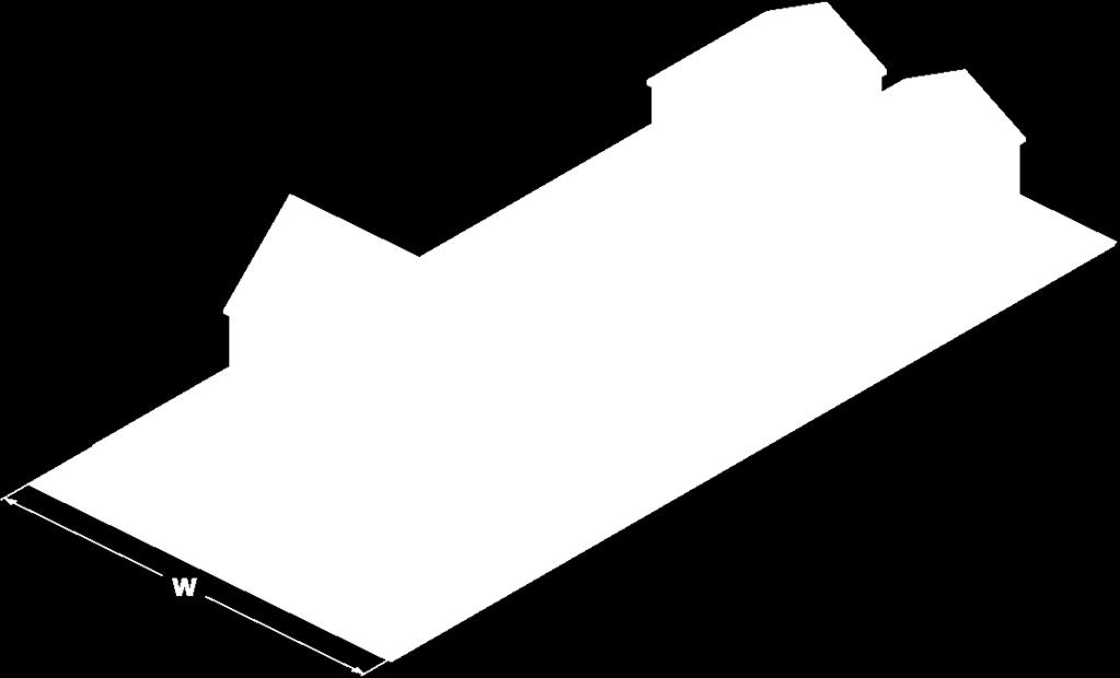
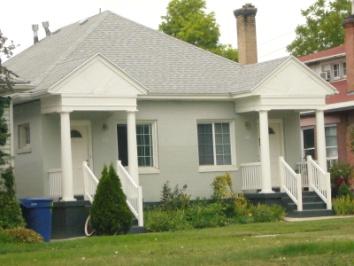
6 public and private spaces, and ensure architectural design will contribute to the character of the neighborhood; 4. Use building form, placement, and orientation to identify the private, semiprivate, and public spaces; 5. Minimize the visual impact of parking areas; and 6. Minimize conflicts between pedestrians, bicyclists, and vehicles. B. Building Types and Forms: 1. Description: The permitted building forms are described in this subsection. Each building form includes a general description and definition, as well as images of what the building form may look like. Building form images are for informational purposes only and not intended to demonstrate exactly what shall be built. The description and images should be used to classify existing and proposed buildings in order to determine what development regulations apply. The drawings are not to scale. They should not be used to dictate a specific architectural style as both traditional and contemporary styles can be used. a. Urban House: A residential structure with the approximate scale of a single dwelling unit, as viewed from the street, but may contain up to two (2) dwelling units. The structure has a single entry facing the street, a front porch or stoop, and a small front yard. Second units may be arranged vertically (up and down) or horizontally (front and back), but the entry to the second unit is from the side, rear, or interior of structure. A third unit may also be located along an alley as a stand alone unit or as a dwelling unit located in an accessory building. All units are on a single lot. Urban House with Detached Dwelling 6
 dwelling units in a single building.")

7 Modern and Traditional Forms Two-Story Contemporary Form b. Two-Family Dwelling: A residential structure that contains two (2) dwelling units in a single building. The units may be arranged side by side, up and down, or front and back. Each unit has its own separate entry directly to the outside. Dwellings may be located on separate lots or grouped on one lot. A third unit may also be located along an alley as a stand alone unit or as a dwelling unit located in an accessory building, but may not be located on a separate lot. 7

8 Two-Family Dwelling with Garages Traditional Two-Family Dwelling 8
 or more detached dwelling units with each unit appearing to be a small single-family dwelling with a common green or open space.")
9 Modern Two-Family Dwelling c. Cottage Development: A unified development that contains two (2) or more detached dwelling units with each unit appearing to be a small single-family dwelling with a common green or open space. Dwellings may be located on separate lots or grouped on one lot. d. Additional Development Standards for Cottage Building Forms: (1) Setbacks between individual cottages: All cottages shall have a minimum setback of eight feet (8 ) from another cottage. (2) Footprint: No cottage shall have a footprint in excess of eight hundred fifty (850) square feet. (3) Building Entrance: All building entrances shall face a public street or a common open space. (4) Open Space: A minimum of two hundred fifty (250) square feet of common, open space is required per cottage up to a maximum of one thousand (1,000) square feet. At least fifty percent (50%) of the open space shall be contiguous and include landscaping, walkways or other amenities intended to serve the residents of the development. Cottage Development on Single Parcel 9


10 Cottage Development e. Row House: A series of attached single-family dwellings that share at least one common wall with an adjacent dwelling unit. A row house contains a minimum of three (3) residential dwelling units. Each unit may be on its own lot. If possible, off street parking is accessed from an alley. Row House on Single Parcel Modern Row House Form 10


11 Traditional Row House Form f. Multi-Family Residential: A multi-family residential structure containing three (3) or more dwelling units that may be arranged in a number of configurations. Multi-Family Residential Form Multi-Family Modern Form 11


12 Multi-Family Traditional Form g. Storefront: A commercial structure that may have multiple stories and contain a variety of commercial uses that are allowed in the district that permits this building type. All buildings, regardless of the specific use, have a ground floor that looks like a storefront. Store Front Form 12

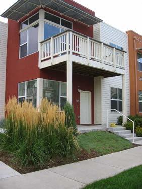
13 Contemporary Store Front Traditional Store Front h. Vertical Mixed Use: A multi-story building that contains a mix of commercial and/or office with residential uses. Vertical Mixed Use Multi-Story Form 13

 square feet, whichever is less. Refer to section the Building Configuration Standards for more information on how to comply with the standards.")
14 Modern Materials Traditional Materials C. Building Form Standards: 1. The provisions of this section shall apply to all properties located within the form based districts as indicated on the maps in each form based district. 2. Building form and street type standards apply to all new buildings and additions when the new construction related to the addition is greater than twenty-five percent (25%) of the footprint of the structure or one-thousand (1,000) square feet, whichever is less. Refer to section the Building Configuration Standards for more information on how to comply with the standards. The graphics included provide a visual representation of the standards as a guide and are not meant to supersede the standards in the tables. Only building forms identified in the table are permitted. 21A : BUILDING CONFIGURATION AND DESIGN STANDARDS: A. Specific Intent of Configuration and Design Standards: 1. Design Related Standards: The design related standards are intended to do the following: 14
15 a. Implement applicable master plans; b. Continue the existing physical character of residential streets while allowing an increase in building scale along arterials and near transit stations; c. Focus development and future growth in the city along arterials and near transit stations; d. Arrange buildings so they are oriented toward the street in a manner that promotes pedestrian activity, safety, and community; e. Provide human scaled buildings that emphasize design and placement of the main entrance/exit on street facing facades; f. Provide connections to transit through public walkways; g. Provide areas for appropriate land uses that encourage use of public transit and are compatible with the neighborhood; h. Promote pedestrian and bicycle amenities near transit facilities to maximize alternative forms of transportation; and i. Rehabilitate and reuse existing residential structures in the form based zoning districts when possible to efficiently use infrastructure and natural resources, and preserve neighborhood character. B. Building Configuration Standards Defined: The building configuration standards are defined in this section. The defined standards in this section are intended to identify how to comply with the building configuration standards tables located in this chapter. C. Building configuration standards apply to all new buildings and additions when the new construction related to the addition is greater than twenty-five percent (25%) of the footprint of the structure or one-thousand (1,000) square feet, whichever is less. The graphics included provide a visual representation of the standards as a guide and are not meant to supersede the standards in the tables. This standard applies to all form based zoning districts unless otherwise indicated. 1. Building Entry: A minimum of one main entry with an entry feature facing a public street or walkway, excluding alleys, is required. The main entry is the primary pedestrian entrance into a building. Two-family dwelling buildings shall have a minimum of one main entry with porch or stoop for at least one of the dwelling units facing a street. The main entry for the second dwelling unit may face the street or side yard, but must also have a porch or stoop entrance. Where required, the building entry must be one of the following: a. Front entrance: Door on the same plane as street facing facade; b. Recessed entrance: Inset behind the plane of the building no more than ten feet (10 ). If inset, then the sidewalls of the inset must be lined with clear glass. Opaque, smoked, or darkened glass is not permitted; or c. Corner entrance: Entry that is angled or an inside corner located at the corner of two (2) intersecting streets. d. Every building shall have at least one (1) entry for every seventy-five feet (75 ) of building façade along a public or private street, alley or greenway. 15
16 2. Encroachments: A permitted entry feature may encroach into a required yard provided no portion of the porch is closer than five feet (5 ) to the front property line. 3. Entry Feature: The following building entries are permitted as indicated: TABLE 21A B ENTRY FEATURE STANDARDS Entry Feature Permitted Based On Building Form Type Urban House Cottage Development Two- Family Dwelling Row House Multi- Family Store front Vertical Mixed Use Porch and fence: A planted front yard where the street facing building facade is set back from the front property line with an attached porch that is permitted to encroach into the required yard. The porch shall be a minimum of six (6) feet in depth. The front yard may include a fence no taller than three (3) feet in height. P P P P P Reference Illustration - Porch and Fence 16
17 Entry Feature Permitted Based On Building Form Type Urban House Cottage Development Two- Family Dwelling Row House Multi- Family Store front Vertical Mixed Use Terrace or lightwell: An entry feature where the street facing facade is set back from the front property line by an elevated terrace or sunken lightwell. May include a canopy or roof. P P P P P Reference Illustration Terrace or Lightwell Entry Feature Permitted Based On Building Form Type Urban House Cottage Development Two- Family Dwelling Row House Multi- Family Store front Vertical Mixed Use Forecourt: An entry feature wherein a portion of the street facing facade is close to the property line and the P P P P P P P 17

18 central portion is set back. The court created must be landscaped, contain outdoor plazas, outdoor dining areas, private yards, or other similar features that encourage use and seating Reference Illustration Forecourt Entry Feature Permitted Based On Building Form Type Urban House Cottage Development Two- Family Dwelling Row House Multi- Family Store front Vertical Mixed Use Stoop: An entry feature wherein the street facing facade is close to the front property line and the first story is elevated from the sidewalk sufficiently to secure privacy for the windows. The P P P P P P P 18

19 entrance contains an exterior stair and landing that is either parallel or perpendicular to the street. Recommended for ground floor residential uses. Reference Illustration Stoop Entry Feature Permitted Based On Building Form Type Urban House Cottage Development Two- Family Dwelling Row House Multi- Family Store front Vertical Mixed Use Shopfront: An entry feature where the street facing facade is close to the property line and building entrance is at sidewalk grade. Building entry is covered with an awning, canopy, or is recessed from the front building P P P 19
20 facade, which defines the entry and provides protection for customers. Reference Illustration Shopfront Entry Feature Permitted Based On Building Form Type Urban House Cottage Development Two- Family Dwelling Row House Multi- Family Store front Vertical Mixed Use Gallery: A building entry where the ground floor is no more than 10 feet from the front property line and the upper levels or roofline cantilevers from the ground floor facade up to the front property line. P P P 20
21 Reference Illustration Gallery 4. Pedestrian Connections: Where required, the following pedestrian connection standards apply: a. The connection shall provide direct access from any building entry to the public sidewalk or walkway. b. The connection shall comply with the Americans with Disabilities Act (ADA) standards for accessibility. c. The connection shall be fully paved and have a minimum width of four feet (4 ). d. The connection shall be separated from vehicle drive approaches and drive lanes by a change in grade and a wheel stop if the walkway is less than eight feet (8 ) wide. e. Pedestrian connections that lead directly from the sidewalk to the primary building entrance may contain wing walls, no taller than two feet (2 ) in height for seating, landscaping, etc. 5. Ground Floor Transparency: Where required, the ground floor transparency standards apply: a. Minimum of sixty percent (60%) of street facing façade, located between two (2) and eight (8) feet above the grade of the sidewalk, shall be transparent glass. This may be reduced to twenty percent (20%) if the ground floor is within one of the following building types: urban house, two-family, cottage, and row house. b. There must be visual clearance behind the glass for a minimum of six feet (6 ). Three-dimensional display windows at least six feet (6 ) deep are permitted and may be counted toward the sixty percent (60%) glass requirement. c. Ground floor windows of commercial uses shall be kept clear at night, free from any window covering, with internal illumination. When ground floor glass conflicts with the internal function of the building, other means shall be used to activate the sidewalk, such as display windows, public art, architectural ornamentation or detailing or other similar treatment. d. The first floor elevation facing a street of all new buildings, or buildings in which the property owner is modifying the size of windows on the front facade, shall comply with these standards. 21
 of the street facing building façade.")
22 6. Building Materials: A minimum of seventy percent (70%) of any street facing building façade shall be clad in high quality, durable, natural materials, such as stone, brick, wood lap siding, fiber cement board siding, shingled or panel sided, and glass. Other materials may count up to thirty percent (30%) of the street facing building façade. Exterior insulation and finishing systems (EIFS) is permitted for trim only. 7. Open Space: A minimum of ten percent (10%) of the lot area shall be provided for open space. Open space may include landscaped yards, patio, dining areas, common balconies, rooftop gardens, and other similar outdoor living spaces. Private balconies shall not be counted towards the minimum open space requirement. Required parking lot landscaping or perimeter parking lot landscaping shall also not count towards the minimum open space requirement. 8. Building Fenestration: No building wall that faces onto a street shall exceed more than thirty feet (30 ) in length without being interrupted by windows, doors, or change of building wall plane that results in an offset of at least twelve inches (12 ). Illustration of Building Fenestration 9. Residential Balconies: All street facing residential units above the ground floor or level shall contain a usable balcony that is a minimum of four feet (4 ) in depth. Balconies may overhang any required yard. 10. Design Standards Alternatives: a. Alternatives to Required Build-To Line: Where a required build-to standard applies, the following alternatives may count toward the minimum build-to requirement as indicated: (1) Landscaping Walls: Landscaping walls between twenty four inches (24 ) and forty two inches (42 ) high may count up to twenty five percent (25%) toward the minimum requirement provided the following: (A) The wall incorporates seating areas. 22
23 (B) The wall is constructed of masonry, concrete, stone or ornamental metal. (C) The wall maintains clear view sightlines where sidewalks and pedestrian connections intersect vehicle drive aisles or streets. (2) Pergolas and Trellises: Pergolas and trellises may count up to twenty five percent (25%) toward the minimum build-to requirement provided the following: (A) The structure is at least forty eight inches (48 ) deep as measured perpendicular to the property line. (B) A vertical clearance of at least eight feet (8 ) is maintained above the walking path of pedestrians. (C) Vertical supports are constructed of wood, stone, concrete or metal with a minimum of six inches by six inches (6 x6 ) or a radius of at least four inches (4 ). (D) The structure maintains clear view sightlines where sidewalks and pedestrian connections intersect vehicle drive aisles or streets. (3) Arcades: Arcades may count up to one hundred percent (100%) toward the minimum requirement provided the following: (A) The arcade extends no more than two (2) stories in height. (B) No portion of the arcade structure encroaches onto public property. (C) The arcade maintains a minimum pedestrian walkway of five feet (5 ). (D) The interior wall of the arcade complies with the building configuration standards. (4) Plazas And Outdoor Dining: Plazas and outdoor dining areas may count up to fifty percent (50%) toward the minimum requirement, and have a maximum front setback of up to fifteen feet (15 ) provided the following: (A) The plaza or outdoor dining is between the property line adjacent to the street and the street facing building facade. (B) Shall be within two feet (2 ) of grade with the public sidewalk. (C) The building entry shall be clearly visible through the courtyard or plaza. (D) The building facades along the courtyard or plaza shall comply with the ground floor transparency requirement. b. Alternatives to Ground Floor Transparency Requirement: The planning director may modify the ground floor transparency requirement in the following instances: 1. The requirement would negatively impact the historical character of a building within the H historic preservation overlay district; or 2. The requirement conflicts with the structural integrity of the building and the structure would comply with the standard to the extent possible. 11. Permitted Encroachments and Height Exceptions: Obstructions and height exceptions are permitted as listed in this section or in Section 21A of this title or as indicated in this subsection. 23

 provided: 1. The additional height does not include additional living space. Vaulted ceilings, storage spaces, and utility spaces are permitted. 2.")

24 a. Canopies: Canopies covering the primary entrance or entrances to a structure may extend into the right of way provided all city processes and requirements for right of way encroachments are complied with. No commercial signs are allowed on entrance canopies if the canopy encroaches into the public right of way. b. Building Height: In order to promote a varied skyline and other roof shapes in the area, structures with a sloped roof may exceed the maximum building height in the form based districts by five feet (5 ) provided: 1. The additional height does not include additional living space. Vaulted ceilings, storage spaces, and utility spaces are permitted. 2. The slope of the roof is a minimum of a twelve-four (12:4) pitch or a quarter barrel shape. Minimum Slope of Pitched Roof Minimum Slope of Quarter Barrel Roof D. Other Applicable Development Standards: 1. Landscaping. Any applicable standard listed in Chapter 21A.48 Landscaping shall be complied with. 2. Signs. All signs shall comply with the standards found in Section 21A Accessory Uses, Building and Structures. All accessory uses, buildings and structures shall comply with the applicable standards in Chapter 21A.40, except as noted below: a. Form Based Urban Neighborhood District Specific Standards for Detached Dwelling Units: 24
25 (1) Detached dwelling units may be built in a required yard as a stand alone unit or attached to an accessory building, such as a garage. (2) Detached dwelling units are only permitted with the urban house, two-family dwelling, and cottage development building forms. (3) No accessory structure containing a detached dwelling unit shall exceed twenty five feet (25 ) in height. (4) If a detached dwelling unit is built as a second level, the minimum setback from property line shall be a minimum of four feet (4 ). (5) All building configuration standards that apply to the primary building form shall also apply to the detached dwelling unit, with the exceptions listed below: (A) The detached dwelling unit shall have an entry feature that faces or is accessible from a public alley when present; (B) The entry feature may be a stoop that has a minimum dimension of four feet by four feet (4 x 4 ); and (C) The ground floor transparency requirement does not apply to detached dwelling units located on the second floor of an accessory structure. b. Form Based Special Purpose Corridor District Specific Standards for Detached or Accessory Parking Garages or Structures: (1) Detached or accessory multi-level parking garages or structures shall have the same setback requirements for principal structures. (2) The minimum setback required shall be landscaped to provide a buffer to the abutting residential district. No structure (primary or accessory) shall be permitted within this landscaped buffer. 4. Parking Regulations. All parking regulations shall comply with the requirements of Chapter 21A Permitted Land Use. All uses allowed in the form based districts can be found in Chapter 21A A : SC AND SE FORM BASED SPECIAL PURPOSE CORRIDOR DISTRICT: A. Subdistricts: 1. Named: The following subdistricts can be found in the form based special purpose corridor form based districts: a. SC Special Purpose Corridor Core Subdistrict: The SC special purpose corridor core subdistrict contains the most intensive level of development in the 25
26 vicinity of special purpose corridors. Buildings are generally six (6) to seven (7) stories in height and are supported by multiple street types so that pedestrians, bicyclists and drivers have access to the properties within the area. Development standards are based on building type. b. SE Special Purpose Corridor Edge Subdistrict: The SE special purpose corridor edge subdistrict is intended to provide an appropriate transition in building size and scale between existing neighborhoods and the Core area. Buildings may be up to four (4) stories in height, with appropriate setbacks when adjacent to lower scale residential neighborhoods. Development regulations are based on building type, with the overall scale, form and orientation as the primary focus. 2. Applicability of Subdistricts: The regulations of the subdistricts shall apply as indicated in the regulating plan map. 26

27 FIGURE 21A A REGULATING PLAN MAP SUGAR HOUSE STREETCAR FORM BASED SPECIAL PURPOSE CORRIDOR AREA B. Street Types 1. Street Types Intent: The intent of identifying specific types of streets in the special purpose corridor districts is to: a. Ensure that a hierarchy of transportation is established; b. Guarantee access to private property; and c. Determine the appropriate manner in which buildings address streets. 2. Street Types Established: The following types of streets are hereby established. The location and applicability of street type regulations are shown on Figure 21A A Regulating Plan Map Sugar House Streetcar Form Based Special Purpose Corridor Area. a. Greenway Street: Streets that contain a streetcar line and stops and various types 27
28 of multi-use trails. Greenway streets may provide access for pedestrians and bicycles. Automobiles are not permitted on Greenway streets. b. Neighborhood Street: Neighborhood streets are intended to serve the adjacent neighborhoods and are generally considered local streets. Automobile access may be provided to each individual lot. Access to certain building forms is not permitted from a Neighborhood street unless the property only has frontage on a Neighborhood street. c. Avenue Street: Avenue streets are those streets that are designed to accommodate a high number of pedestrians. Automobiles access to private property may be permitted. Pedestrians are the priority. d. Boulevard Street: Boulevard streets are designed to provide automobile and service access in a manner that balances the needs of automobiles and pedestrians. C. SC Building Form Standards. Building form standards are listed below in Table 21A C. TABLE 21A C SC BUILDING FORM STANDARDS Permitted Building Forms Multi-Family and Store Front H F B Maximum Building Height Limitation on Commercial Uses Front and Corner Side Yard Setback Required Build-To Greenway Neighborhood Avenue Boulevard Maximum building height in the SC is 60 feet. An additional 15 feet in height (for a total height of 75 feet) may be permitted for residential uses if a minimum of 10% of the units are affordable housing. Commercial or nonresidential uses are limited to the first 3 stories and a height of 45 feet. This limitation does not apply to hotel/motel uses, which are limited to the maximum height of 75 feet. Minimum of 5 feet. Maximum of 15 feet. Minimum of 15 feet. Maximum of 25 feet. Minimum of 5 feet. Maximum of 10 feet. Minimum of 15 feet. Maximum of 25 feet. Minimum of 50% of any street facing façade shall be built to the minimum setback line. At least 10% of any street facing façade shall be building the maximum setback line. 28
29 S R L Interior Side Yard Rear Yard Minimum Lot Size When adjacent to a residential district, a minimum setback of 25% of the lot width, up to 25 feet, is required. Any portion of the building taller than 30 feet must be stepped back two feet from the required building setback line for every one foot of height over 30 feet. When adjacent to other zoning districts, no minimum setback is required. See illustration below. When adjacent to a residential district, a minimum setback of 25% of the lot width, up to 25 feet, is required. Any portion of the building taller than 30 feet must be stepped back two feet from the required building setback line for every one foot of height over 30 feet. When adjacent to other zoning districts, no minimum setback is required. See illustration below. 4,000 square feet; not to be used to calculate density. W Minimum Lot Width DU BF Dwelling Units per Building Form Number of Building Forms per Lot 50 feet No minimum or maximum. One building form permitted for every 4,000 square feet of lot area provided all building forms have frontage on a street. Interior Side Yard and Rear Yard Illustration 29

30 D. SE Building Form Standards. Building form standards are listed below in Table 21A D TABLE 21A D SE BUILDING FORM STANDARDS H F Permitted Building Forms Cottage, Row House, Multi-Family and Store Front Maximum Building Maximum building height in the SE is 45 feet. Height Limitation on Commercial Uses Front and Corner Side Yard Setback Commercial or nonresidential uses are limited to the first 2 stories and a height of 30 feet. Greenway Minimum of 5 feet. Maximum of 15 feet. Neighborhood Minimum of 15 feet. Maximum of 25 feet. Avenue Minimum of 5 feet. Maximum of 10 feet. Boulevard Minimum of 15 feet. Maximum of 25 feet. B Required Build-To S Interior Side Yard Minimum of 50% of street facing façade shall be built to the minimum setback line. When adjacent to a residential district, a minimum setback of 25% of the lot width, up to 25 feet, is required. Any portion of the building taller than 30 feet must be stepped back two feet from the required building setback line for every one foot of height over 30 feet. When adjacent to other zoning districts, no minimum setback is required. See illustration below. 30

31 R Rear Yard L Minimum Lot Size W Minimum Lot Width Dwelling Units per DU Building Form BF Number of Building Forms per Lot When adjacent to a residential district, a minimum setback of 25% of the lot width, up to 25 feet, is required. Any portion of the building taller than 30 feet must be stepped back two feet from the required building setback line for every one foot of height over 30 feet. When adjacent to other zoning districts, no minimum setback is required. See illustration below. 4,000 square feet; not to be used to calculate density. 50 feet No minimum or maximum. One building form permitted for every 4,000 square feet of lot area provided all building forms have frontage on a street. 21A : UN1 AND UN2 FORM BASED URBAN NEIGHBORHOOD STANDARDS: A. Subdistricts: 1. Named: The following subdistricts can be found in the urban neighborhood form based districts: a. UN1 Urban Neighborhood 1 Subdistrict: Generally includes small scale structures, up to two and one-half (2.5) stories in height, on relatively small lots with up to four (4) dwelling units per lot depending on building type. Reuse of 31
32 existing residential structures is encouraged. Development regulations are based on the building type. b. UN2 Urban Neighborhood 2 Subdistrict: Generally includes buildings up to four (4) stories in height, with taller buildings located on street corner parcels, which may contain a single use or a mix of commercial, office, and residential uses. Development regulations are based on building type, with the overall scale, form, and orientation of buildings as the primary focus. 2. Applicability of Subdistricts: The regulations of the subdistricts shall apply as indicated in the regulating plan map. FIGURE 21A A REGULATING PLAN MAP WEST TEMPLE GATEWAY AREA 32

33 B. UN1 Building Form Standards. Building form standards are listed below in Table 21A B 33
34 TABLE 21A B UN1 BUILDING FORM STANDARDS Building Form Building Regulation Urban House Two-Family Dwelling Cottage Development 1 Row House Building Height and Placement: H Height 2.5 stories, maximum of 30, measured from established grade F Front and corner side yard setback Equal to average setback of block face, where applicable, otherwise minimum of 10 and maximum of 20 S Interior side yard Minimum 4 R Rear yard Minimum of 20% lot depth up to 25 4 minimum Minimum of 20% lot depth up to 25 L Minimum lot size 3,000 sq. ft.; not to be used to calculate density 1,500 sq. ft.; not to be used to calculate density 1,500 sq. ft.; not to be used to calculate density W Minimum lot width per unit 15 per unit facing a street 15 per unit. Side orientation allowed provided building configuration standards are complied with DU Maximum dwelling units per building form 2 units plus 1 detached accessory unit 2 units plus 1 detached accessory unit 1 unit per cottage, multiple cottages per lot Minimum of 3; maximum of 4 BF Number of building forms per lot 1 building form permitted for every 3,000 sq. ft. of lot area 1 cottage for every 1,500 sq. ft. of lot area 1 building form permitted for every 1,500 square feet of lot area Parking: Surface parking in front and corner side yards Not permitted Vehicle access If off street parking is provided, vehicle access from an alley is required when property is served by a public or private alley with access rights. Vehicle access from street is only permitted when no alley access exists. If pull through parking is required by fire or other code, ingress shall be from street and egress onto alley. Parking on separate lots Not permitted Parking may be provided on an adjacent lot or in a common area associated with the development 34
35 Attached garages and carports Attached garages and carports are required to be accessed from the rear yard where the rear yard is accessible by an alley with access rights to the subject property. If there is no access to the rear yard, an attached garage may be accessed from the front or corner side yard provided the garage door (or doors) is no wider than 50% of the front facade of the structure and set back at least 5 feet from the street facing building facade and at least 20 feet from the property line. Side loaded garages are permitted Note: 1. See subsection 21A B.1.d of this chapter for additional standards. C. UN2 Building Form Standards. Building form standards are listed below in Table 21A C TABLE 21A C UN2 BUILDING FORM STANDARDS Building Form Building Regulation Cottage Development 1 Row House Multi- Family Residential Mixed Use Storefront Building Height and Placement: H Height 2.5 stories, 30 maximum from established grade 4 stories with a maximum of stories with a maximum of 65 on parcels located on the corners of West Temple at 800 or 900 South, 200 West at 700, 800 or 900 South, 200 West at Fayette Avenue, and 300 West at 800 or 900 South. All heights measured from established grade F Front and corner side yard setback No minimum Maximum 10 B Required build-to Minimum of 50% of street facing facade shall be built to the minimum setback line S Interior side yard Minimum of 15 along a side property line adjacent to UN1, otherwise 4 setback required. Parcels separated by an alley are not considered adjacent R Rear yard Minimum of 25 when rear yard is adjacent to UN1 otherwise no setback required. Parcels separated by an alley are not considered adjacent Minimum of 15 along a side property line adjacent to UN1, otherwise no setback required. Parcels separated by an alley are not considered adjacent Minimum of 20 when rear yard is adjacent to UN1 U Upper level step back When adjacent to lot in the UN1, buildings shall be stepped back 1 additional foot for every foot of building height above 35. When a parcel in the UN2 district is separated from a parcel in the UN1 district by an alley, the width of the alley may be counted toward the upper level step back 35
36 L Minimum lot size 4,000 sq. ft.; not to be used to calculate density 1,500 sq. ft.; not to be used to calculate density 4,000 sq. ft.; not to be used to calculate density W Minimum lot width 15 per unit facing a street Side orientation allowed provided building configuration standards are complied with 30 DU Dwelling units per building form 1 per cottage Minimum of 3; maximum of 5 No minimum or maximum BF Number of building forms per lot 1 cottage for every 1,000 square feet of lot area 1 building form permitted for every 1,000 square feet of lot area 1 building form permitted for every 4,000 square feet of lot area Parking: Surface parking in front and corner side yards Vehicle access Not permitted If off street parking is provided, vehicle access from an alley is required when property is served by a public or private alley with access rights. Vehicle access from street is only permitted when no alley access exists. If pull through parking is required by fire or other code, ingress shall be from street and egress onto alley If property is less than 30 wide, vehicle access from an alley is required when property is served by a public or private alley with access rights. If no alley access exists, only 1 vehicle access point from a street may be permitted If property is 30 wide or more, only 1 vehicle access point from a street may be permitted. If property is served by a public or private alley, ingress shall be from street and egress onto alley unless otherwise permitted by this section Corner lots with a minimum width of 120 may have 1 vehicle access point per street frontage. Vehicle access may be one-way or multi-directional Vehicle access width at street Vehicle access from street design standards When a one-way vehicle drive is included in a development, no vehicle drive or curb cut may exceed 12 in width. When a multi-directional vehicle drive is included, a curb cut may not exceed 24 in width. If vehicle access is from a street, the following additional design standards shall apply: garage entry shall have a minimum 20 setback from property line; garage entry may not exceed 50% of first floor building width; one-way garage entry may not exceed 14 in width; multiway garage entry may not exceed 26 in width; garage door or gate shall be constructed of durable building materials and compatible with building design. 36
37 Driveway location Vehicle access and parking compliance Parking on separate lots Attached garages and carports The minimum distance between curb cuts shall be 12. Driveways shall be at least 6 from abutting property lines for a depth of 10 unless shared. Driveways shall be at least 12 from property lines adjacent to a street corner or 5 from the point of tangency of the curb return, whichever is greater. Abandoned curb cuts shall be removed and replaced with city standard curb All new drive approaches, driveways, and parking lots shall comply with form based urban neighborhood regulations, and all other applicable sections of this code. Existing drive approaches, driveways, and parking lots shall be made compliant with form based urban neighborhood regulations upon change of use, increase in parking, or building additions greater than 25% of the footprint of the structure or 1,000 sq. ft., whichever is less Parking may be provided on an adjacent lot, or in a common area associated with the development, or within 500 of the property. If located on an adjacent parcel or on a parcel within 500, the proposed location of the parking shall contain a principal building and the parking shall be located behind a principal building Attached garages and carports are required to be accessed from the rear yard where the rear yard is accessible by an alley with access rights to the subject property. If there is no access to the rear yard, an attached garage may be accessed from the front or corner side yard provided that the garage door (or doors) is no wider than 50% of the front facade of the structure and the entry to the garage is set back at least 10' from the street facing building facade and at least 20' from a public sidewalk. Side loaded garages are permitted Note: 1. See subsection 21A B.1.d of this chapter for additional standards. SECTION 3. Adopting Section 21A That Section 21A of the Salt Lake City Code (Zoning: Land Use Tables: Table of Permitted and Conditional Uses in Form Based Districts), shall be, and hereby is adopted to read and appear as follows: 21A TABLE OF PERMITTED USES IN FORM BASED CODE DISTRICTS Note: Uses which are not listed in the following table are not permitted in any form based code zoning district. Legend: P = Permitted C = Conditional Use Accessory use, except those that are specifically regulated in this chapter, or elsewhere in this title Permitted Uses by District UN1 UN2 SC SE P P P P Alcohol: 37
38 Brewpub P P C Social club P P C Tavern, 2,500 square feet or less in floor area P P C Animal, veterinary office P P P Antenna, communication tower P P P Art gallery P P P Bed and breakfast P P P P Bed and breakfast inn P P P P Bed and breakfast manor P P P P Clinic (medical, dental) P P P Community garden P P P P Community recreation center P P P Daycare center, adult P P P Daycare center, child P P P Dwelling: Assisted living facility (limited capacity) P P P P Assisted living facility (small) P P P Group home (large) P P P Group home (small) when located above or below first story office, retail, or commercial use, or on the first story where the unit is not located adjacent to street frontage P P P Multi-family P P P Residential support (large) Residential support (small) Rooming (boarding) house P P P Single-family attached P P P Single-family detached P Single-family detached (Cottage Development building form only) P P Single room occupancy P Two-family P Eleemosynary facility P P P Farmers market P P P Financial institution P P P Food processing P 38
39 Funeral home P P P Health and fitness facility P P P Hotel/motel P P House museum in landmark site P P P P Laboratory (medical, dental, optical) P P P Library P P P Mixed use developments including residential and other uses allowed in the zoning district P P P Museum P P P Nursing care facility P P P Office P P P Office and/or reception center in landmark site P P P Open space P P P P Park P P P P Parking, off site P 1 P 1 P 1 P 1 Photo finishing lab P P Place of worship P P P Plazas P P P P Recreation (indoor) P P P Research and development facility P P P Research facility (medical/dental) P P P Restaurant P P P Retail goods establishment P P P Retail goods establishment, plant and garden shop with outdoor retail sales area P P P Retail service establishment P P P Sales and display (outdoor) P P P School: College or university P P P Music conservatory P P P Professional and vocational P P P Seminary and religious institute P P P Seasonal farm stand P P P Solar array P P P 39
40 Store, specialty P P P Studio, art P P P Studio, dance P P P Theater, movie P P P Urban farm P P P P Utility, building or structure P P P P Utility, transmission wire, line, pipe, or pole P P P P Vending cart, private property P P P Wireless telecommunications facility P P P SECTION 4. Adopting Section 21A That Section 21A of the Salt Lake City Code (Zoning: Signs: Sign Regulations for Form Based Districts), shall be, and hereby is adopted to read and appear as follows: 21A : SIGN REGULATIONS FOR FORM BASED CODE DISTRICTS: The following regulations shall apply to signs permitted in the form based code zoning districts. Any sign not expressly permitted by these district regulations is prohibited. A. Sign Regulations for the Form Based Code Districts: 1. Purpose: Sign regulations for the form based code zoning districts are intended to provide appropriate signage oriented primarily to pedestrian and mass transit traffic. 2. Applicability: This subsection applies to all signs located within the form based code zoning districts. This subsection is intended to list all permitted signs in the zone. All other regulations in chapter 21A.46, Signs, of this title shall apply. B. Sign Type, Size and Height Standards: 40
 may extend up to 6 inches in any direction beyond the sign face. Maximum of 3 feet.")
41 1. A-Frame Sign Sign Type UN1 UN2 SC SE Specifications Quantity 1 per leasable space. Leasable spaces on corners may have 2. A-frame sign P P P Width Height Maximum of 2 feet. Any portion of the frame (the support structure) may extend up to 6 inches in any direction beyond the sign face. Maximum of 3 feet. Any portion of the frame (the support structure) may extend up to 6 inches in any direction beyond the sign face. Placement On public sidewalk or private property. Obstruction Free Area Minimum of 8 feet must be maintained at all times for pedestrian passage. 2. Awning or Canopy Sign Sign Type UN1 UN2 SC SE Specifications Quantity 1 per window. Width Equal to the width of the window. Awning or canopy sign P P P P Projection No maximum depth from building facade, however design subject to mitigation of rainfall and snowfall runoff, conflict avoidance with tree canopy, and issuance of encroachment permits where required. The awning or canopy can project a maximum of 2 feet into a special purpose corridor. 41

42 Clearance Letters and logos Location Permitted Minimum of 10 feet of vertical clearance. Allowed on vertical portions of sign only. Private property or a public street. Signs can face a special purpose corridor but must be located on private property. All signs are subject to the requirements of the revocable permitting process. 3. Construction Sign Sign Type UN1 UN2 SC SE Specifications Construction sign (see definition in chapter 21A.46 of this title) P P P P Quantity Height Area Location Permitted 1 per construction site Maximum of 8 feet Maximum of 64 square feet Private property or a public street. Signs can face the special purpose corridor, but must be located on private property. 4. Flat Sign Sign Type UN1 UN2 SC SE Specifications Quantity 1 per leasable space. Leasable spaces on corners may have 2 Flat sign P P P Width Height Area Maximum of 90% of width of leasable space Maximum of 3 feet 1½ square feet per linear foot of store frontage 42

43 Projection Maximum of 1 foot 5. Nameplate Sign Sign Type UN1 UN2 SC SE Specifications Nameplate sign P P P P Quantity Area 1 per leasable space. Leasable spaces on corners may have 2 Maximum of 3 square feet 6. Private Directional Sign Sign Type UN1 UN2 SC SE Specifications Quantity No limit Private directional sign (see definition in chapter 21A.46 of this title) P P P P Height Area Restriction Location Permitted Maximum of 5 feet Maximum of 8 square feet May not contain business name or logo Private property or public street. Signs can face the special purpose corridor but must be located on private property. All signs are subject to the requirements of the revocable permitting process. 43
44 7. Projecting Sign Sign Type UN1 UN2 SC SE Specifications Quantity 1 per leasable space. Leasable spaces on corners may have 2 Clearance Minimum of 10 feet above sidewalk/walkway Projecting sign P P P Area Projection 6 square feet per side, 12 square feet total Maximum of 4 feet from building façade Location Permitted Private property or public street. Signs can face the special purpose corridor but must be located on private property. All signs are subject to the requirements of the revocable permitting process. 8. Projecting Parking Entry Sign Sign Type UN1 UN2 SC SE Specifications Quantity One per parking entry. Clearance Minimum of 10 feet above sidewalk/walkway Projecting sign (see project sign graphic) P P Height Area Projection Maximum of 2 feet. 4 square feet per side, 8 square feet total Maximum of 4 feet from building façade for public and private streets. Maximum of two feet within the special purpose corridor. Location Permitted Private property or public street. Signs can face the special purpose corridor but must be located on private property. All signs are subject to the requirements of the revocable permitting process. 44
 P P P P Height Area Projection Location Permitted Maximum of 6 feet 8 square feet Maximum of 1 foot Private property or public street.")
45 9. Public Safety Sign Sign Type UN1 UN2 SC SE Specifications Quantity No limit Public safety sign (see definition in chapter 21A.46 of this title) P P P P Height Area Projection Location Permitted Maximum of 6 feet 8 square feet Maximum of 1 foot Private property or public street. Signs can face the special purpose corridor but must be located on private property. All signs are subject to the requirements of the revocable permitting process. 10. Real Estate Sign Sign Type UN1 UN2 SC SE Specifications Quantity 1 per leasable space. Leasable spaces on corners may have 2 Real estate sign P P Height Area Location Permitted Maximum of 12 feet 32 square feet Private property or public street. Signs can face the special purpose corridor but must be located on private property. All signs are subject to the requirements of the revocable permitting process. 45
Article 3. SUBURBAN (S-) NEIGHBORHOOD CONTEXT
 NEIGHBORHOOD CONTEXT") Article 3. SUBURBAN (S-) NEIGHBORHOOD CONTEXT this page left intentionally blank Contents ARTICLE 3. SUBURBAN (S-) NEIGHBORHOOD CONTEXT DIVISION 3.1 NEIGHBORHOOD CONTEXT DESCRIPTION...3.1-1 Section 3.1.1
Article 3. SUBURBAN (S-) NEIGHBORHOOD CONTEXT this page left intentionally blank Contents ARTICLE 3. SUBURBAN (S-) NEIGHBORHOOD CONTEXT DIVISION 3.1 NEIGHBORHOOD CONTEXT DESCRIPTION...3.1-1 Section 3.1.1
Chapter 17-2 Residential Districts
 Chapter 17-2 Residential Districts 17-2-0100 District Descriptions...2-1 17-2-0200 Allowed Uses...2-2 17-2-0300 Bulk and Density Standards...2-5 17-2-0400 Character Standards...2-18 17-2-0500 Townhouse
Composition of traditional residential corridors.
 Page 1 of 7 St. Petersburg, Florida, Code of Ordinances >> PART II - ST. PETERSBURG CITY CODE >> Chapter 16 - LAND DEVELOPMENT REGULATIONS >> SECTION 16.20.060. CORRIDOR RESIDENTIAL TRADITIONAL DISTRICTS
DEVELOPMENT STANDARDS FOR RESIDENTIAL PROJECTS RESIDENTIAL BUILDING TYPES: APPROPRIATE ZONES AND DENSITIES 2-1
 2 DEVELOPMENT STANDARDS FOR RESIDENTIAL PROJECTS RESIDENTIAL BUILDING TYPES: APPROPRIATE ZONES AND DENSITIES 2-1 This Chapter presents the development standards for residential projects. Section 2.1 discusses
Table of Contents ARTICLE 5A CHARACTER-BASED ZONING 1
 Table of Contents ARTICLE 5A CHARACTER-BASED ZONING 1 SECTION 10.5A10 GENERAL... 1 10.5A11 Purpose and Intent... 1 10.5A12 Applicability... 1 10.5A13 Compliance with Regulating Plan... 1 10.5A14 Relationship
ARTICLE 5. COMMERCIAL AND OFFICE DISTRICTS 5.1 PURPOSE STATEMENTS 5.2 USES 5.3 DIMENSIONAL STANDARDS 5.4 DESIGN STANDARDS 5.5 DK DISTRICT STANDARDS 5
 ARTICLE 5. COMMERCIAL AND OFFICE DISTRICTS 5.1 PURPOSE STATEMENTS 5.2 USES 5.3 DIMENSIONAL STANDARDS 5.4 DESIGN STANDARDS 5.5 DK DISTRICT STANDARDS 5.6 CU DISTRICT STANDARDS 5.7 SW DISTRICT STANDARDS THE
Article 2. Rules of Interpretation
 Article 2. Rules of Interpretation Article 2. Rules of Interpretation Sec. 2.1. Building Types 2.1.1. Building Type Descriptions... 2-2 Sec. 2.2. Rules Applicable to all Districts 2.2.1. Site... 2-5 2.2.2.
Table of Contents ARTICLE 5A CHARACTER-BASED ZONING 1
 Table of Contents ARTICLE 5A CHARACTER-BASED ZONING 1 SECTION 10.5A10 GENERAL... 1 10.5A11 Purpose and Intent... 1 10.5A12 Applicability... 1 10.5A13 Compliance with Regulating Plan... 1 10.5A14 Relationship
Chapter DOWNTOWN ZONING DISTRICTS
 Chapter 20.14 Sections: 20.14.010 Purpose of the Downtown Zoning Districts 20.14.020 Land Use Regulations for Downtown Zoning Districts 20.14.030 Development Standards for Downtown Zoning Districts 20.14.010
THE CITY COUNCIL OF NORTH ROYALTON, OHIO
 THE CITY COUNCIL OF NORTH ROYALTON, OHIO ORDINANCE NO. 16-113 INTRODUCED BY: Nickell, Kasaris, Antoskiewicz AN ORDINANCE AMENDING THE CODIFIED ORDINANCES OF THE CITY OF NORTH ROYALTON, PART 12 PLANNING
AN ORDINANCE OF THE CITY OF MINNEAPOLIS. By Palmisano
 AN ORDINANCE OF THE CITY OF MINNEAPOLIS By Palmisano Amending Title 20, Chapter 520 of the Minneapolis Code of Ordinances relating to Zoning Code: Introductory Provisions. The City Council of the City
ARTICLE 10 SPECIAL PURPOSE DISTRICTS
 ARTICLE 10 SPECIAL PURPOSE DISTRICTS Sec. 29.1000. SPECIAL PURPOSE DISTRICTS. (1) Purpose. Each Special Purpose District will appear on the City's Zoning Map as a Base Zone. The Special Purpose Districts
Article 6. GENERAL URBAN (G-) NEIGHBORHOOD CONTEXT
 NEIGHBORHOOD CONTEXT") Article 6. GENERAL URBAN (G-) NEIGHBORHOOD CONTEXT this page left intentionally blank Contents ARTICLE 6. GENERAL URBAN (G-) NEIGHBORHOOD CONTEXT DIVISION 6.1 NEIGHBORHOOD CONTEXT DESCRIPTION...6.1-1 Section
Article 6. GENERAL URBAN (G-) NEIGHBORHOOD CONTEXT this page left intentionally blank Contents ARTICLE 6. GENERAL URBAN (G-) NEIGHBORHOOD CONTEXT DIVISION 6.1 NEIGHBORHOOD CONTEXT DESCRIPTION...6.1-1 Section
BYLAW NO. 15/026 A BYLAW OF THE REGIONAL MUNICIPALITY OF WOOD BUFFALO TO AMEND THE LAND USE BYLAW NO. 99/059
 Attachment 2 BYLAW NO. 15/026 A BYLAW OF THE REGIONAL MUNICIPALITY OF WOOD BUFFALO TO AMEND THE LAND USE BYLAW NO. 99/059 WHEREAS Section 639 of the Municipal Government Act requires every municipality
Sedro woolley, WA 720 MURDOCK ST. FOR sale. 14,500 +/- sf office building with 8,500 +/- sf unfinished basement space on 0.
 720 MURDOCK ST Sedro woolley, WA FOR sale 14,500 +/- sf office building with 8,500 +/- sf unfinished basement space on 0.27 +/- AC Former City Hall built in 1930 Located in the Downtown Sedro Woolley core
Appendix1,Page1. Urban Design Guidelines. Back to Back and Stacked Townhouses. DRAFT September 2017
 Appendix1,Page1 Urban Design Guidelines DRAFT September 2017 Back to Back and Stacked Townhouses Appendix1,Page2 Table of Contents 1 Introduction 1 1.1 Purpose 1 1.2 Urban Design Objectives 1 1.3 Building
BOROUGH OF HOPATCONG ORDINANCE No
 BOROUGH OF HOPATCONG ORDINANCE No. 10-2014 AN ORDINANCE OF THE BOROUGH OF HOPATCONG, SUSSEX COUNTY, NEW JERSEY TO ADOPT A FORM BASED CODE AS AN OVERLAY DISTRICT AFFECTING PORTIONS OF THE B-1 AND R-1 ZONING
. \. structure. portion of a. yard setback. in height. for that. above 45 ft. structure above. 20-ft. front. 2, additional.
 Z089-254(RB) E-1 REGULATIONS Front Yard YARD, LOT, AND SPACE 00. \.,, Max.-6Oft. Mm. 15 ft. maximum front yard right-of-ways other way is dedicated existing Ft. Worth ft. from Ft. Worth Ave. or rights
3.1 Existing Built Form
 3.1 Existing Built Form There is a wide variety of built form in the study area, generally comprising 2 and 3 storey buildings. This stretch of Queen Street East is somewhat atypical of Toronto's main
Anacortes, WA. 718 commercial ave. FOR lease. 2,320 +/- sf retail space in a 10,820 +/- sf building. Located in historic downtown Anacortes
 718 commercial ave Anacortes, WA FOR lease 2,320 +/- sf retail space in a 10,820 +/- sf building Located in historic downtown Anacortes Frontage on Commercial Ave alongside four other retail spaces Zoned
Coding For Places People Love Main Street Corridor District
 Coding For Places People Love Main Street Corridor District 1) Scope a) District boundaries are assigned according to the District Boundary Map. b) The Primary Retail Corridor is assigned according to
ARTICLE 4: SCHEDULE OF DISTRICT, USE AND SETBACK REGULATIONS
 Page 1 of 48 City of Hollywood Zoning and Land Development Regulations 4.6.I Beach Community Redevelopment Districts. 1. Purpose. To establish development standards for the Beach Community Redevelopment
David J. Gellner, AICP, Principal Planner, ,
 Staff Report PLANNING DIVISION COMMUNITY & ECONOMIC DEVELOPMENT To: From: Salt Lake City Planning Commission David J. Gellner, AICP, Principal Planner, 801-535-6107, david.gellner@slcgov.com Date: March
3 3 MIXED-USE DISTRICTS
 .1 INTENT MIXED-USE DISTRICTS.1 INTENT For the purposes of this ordinance, the standards and provisions for mixed-use districts are designed to create walkable, mixed-use environments whereas the rural,
2 OVERVIEW & GUIDE. 2.1 ZONING ATLAS OVERVIEW...9 Zoning Districts 9 Transit Areas 10 Pedestrian Streets 10
 2 OVERVIEW & GUIDE 2.1 ZONING ATLAS OVERVIEW...9 Zoning Districts 9 Transit Areas 10 Pedestrian Streets 10 2.2 BUILDING TYPES OVERVIEW...11 General 11 Building Assembly 11 Understanding the Building Type
Part 4.0 DEVELOPMENT REGULATIONS
 M A I N S T R E E T N O R T H Part 4.0 DEVELOPMENT REGULATIONS 4.1 Districts 4.2 Permitted and Prohibited Uses, Standards and Standard Specific Criteria and Other General Provisions 4.3 DPS REGULATIONS
ARTICLE 887. PD 887. Valley View - Galleria Area Special Purpose District
 ARTICLE 887. PD 887. Valley View - Galleria Area Special Purpose District SEC. 51P-887.101. LEGISLATIVE HISTORY. PD 887 was established by Ordinance No. 29032, passed by the Dallas City Council on June
TOWNHOUSE. TYPICAL UNIT SIZE 1,200 to 1,600 square foot average unit (two to three stories) DENSITY dwelling units/acre without cottages
 DENSITY dwelling units/acre without cottages") TOWNHOUSE Townhouses are typically two to three stories in height. Some townhouses include separate rental units, either on the top or bottom floor of a three-story townhouse unit, or in a cottage above
TOWNHOUSE Townhouses are typically two to three stories in height. Some townhouses include separate rental units, either on the top or bottom floor of a three-story townhouse unit, or in a cottage above
Public Review of the Slot Home Text Amendment
 Public Review of the Slot Home Text Amendment The proposed amendments to the Denver Zoning Code have been informed by the Slot Home Strategy Report. This document has been developed out of a robust process
Infill & Other Residential Design Review
 Infill & Other Residential Design Review December 2018 Infill and Other Residential Design Review applies to projects that are located within the Infill Regulations District, on properties immediately
TABLE OF CONTENTS. Chapters and Sections
 TABLE OF CONTENTS Chapters and Sections Chapter 9.02 Permits and Approvals [Addition]... 1 9.02.090 Administrative variances.... 1 Chapter [New]... 1 9.07.091 Purpose and Intent... 1 9.07.092 Applicability...
Sec Tier 2 principal uses and structures. The principal uses of land and structures allowed in Tier 2 are provided below subject to the
 Sec. 27-730.4.9. Tier 2 principal uses and structures. The principal uses of land and structures allowed in Tier 2 are provided below subject to the standards and limitations contained within this division.
Chapter Residential Mixed Density Zone
 Chapter 19.16 Residential Mixed Density Zone 19.16.010 Purpose and Intent 19.16.020 Permitted Uses 19.16.030 Accessory Permitted Uses 19.16.040 Secondary Permitted Uses 19.16.050 Conditional Uses 19.16.060
Section 1. Appendix A, "Zoning" of the Code of the City of Charlotte is hereby amended as follows:
 Petition No. 2009-078 Petitioner: Charlotte-Mecklenburg Planning Commission ORDINANCE NO. AN ORDINANCE AMENDING APPENDIX A OF THE CITY CODE ZONING ORDINANCE Revised 12-10-09 BE IT ORDAINED BY THE CITY
May 12, Chapter RH HILLSIDE RESIDENTIAL ZONES REGULATIONS Sections:
 May 12, 2017 Chapter 17.13 RH HILLSIDE RESIDENTIAL ZONES REGULATIONS Sections: 17.13.010 Title, intent, and description. 17.13.020 Required design review process. 17.13.030 Permitted and conditionally
Rezoning Petition Pre-Hearing Staff Analysis April 17, 2017
 Rezoning Petition 2017-041 Pre-Hearing Staff Analysis April 17, 2017 REQUEST Current Zoning: R-5 (single family residential), R-22MF (multifamily residential), and I-1 (light industrial) Proposed Zoning:
City of Chico Title 19 Land Use & Development Regulations TND Zone
 City of Chico Title 19 Land Use & Development Regulations TND Zone Adopted by the City of Chico July 3, 2002 (Ordinance #2358) TITLE 19 LAND USE AND DEVELOPMENT REGULATIONS TABLE OF CONTENTS DIVISION VI.
Flex Business Overlay Districts
 Intent Section -.00 Chapter Section -.00 Intent The (FB) are designed to foster vital, lively, and sustainable development that creates an imageable neighborhood identity for the various portions of the
City of Lynden Title 19 ZONING
 City of Lynden Title 19 ZONING Chapters Page Number 19.03 Comprehensive Plan 2 19.05 General Provisions 3 19.09 Maps and District Boundaries 4 19.11 Districts Established 5 19.13 Agricultural Zone 6 19.15
5.1 Site Planning & Building Form
 5 Built Form 5.1 Site Planning & Building Form Pearson Dogwood Policy Statement Site Planning & Building Form The redevelopment of Pearson Dogwood will create an attractive and sustainable urban community
SECTION 822 "R-1-A" AND "R-1-AH" - SINGLE FAMILY RESIDENTIAL DISTRICTS
 SECTION 822 "R-1-A" AND "R-1-AH" - SINGLE FAMILY RESIDENTIAL DISTRICTS The "R-1-A" and "R-1-AH" Districts are intended to provide for the development of single family residential homes at urban standards
Chapter DOWNTOWN STATION AREA SPECIFIC PLAN DISTRICT
 Chapter 20.280 DOWNTOWN STATION AREA SPECIFIC PLAN DISTRICT Sections: 20.280.001 Purpose 20.280.002 Sub-Districts 20.280.003 Land Use Regulations 20.280.004 Development Standards 20.280.005 Additional
ARTICLE 5.0 SCHEDULE OF REGULATIONS
 ARTICLE 5.0 SCHEDULE OF REGULATIONS Section 5.101 Table of Dimensional Standards by District. Dimensional Standards AG AG with sewer Districts Rural Residential Business Other SF SF with sewer R-1 R-1
No principal structure shall be located any closer to any. street or property line than the required minimum setback as
 ARTICLE V Yard and Setback Regulations 1. General requirements. No principal structure shall be located any closer to any street or property line than the required minimum setback as set forth in Article
PERMITTED USES: Within the MX-1 Mixed Use Neighborhood District the following uses are permitted:
 6.25 MX-1 - MIXED USE NEIGHBORHOOD 6.25.1 INTENT: The purpose of the MX-1 Mixed Use Neighborhood District is to accommodate the development of a wide-range of residential and compatible non-residential
Single-Dwelling Zones 110
 Title 33, Planning and Zoning Chapter 33.110 1/1/15 Single-Dwelling Zones 33.110 Single-Dwelling Zones 110 Sections: General 33.110.010 Purpose 33.110.020 List of the Single-Dwelling Zones 33.110.030 Other
ARTICLE IV DISTRICT REGULATIONS
 PART 1. RESIDENTIAL DISTRICTS 4-101. RS. Single-Family Residential Suburban District. The RS District is designed for single-family dwellings, and compatible uses, at a density no greater than one dwelling
4 DEVELOPMENT STANDARDS FOR
 4 DEVELOPMENT STANDARDS FOR RESIDENTIAL MIXED-USE PROJECTS This chapter presents standards for residential mixed-use projects in the Ashland-Cherryland Business District and the Castro Valley Central Business
LITTLE MOUNTAIN ADJACENT AREA REZONING POLICY
 LITTLE MOUNTAIN ADJACENT AREA REZONING POLICY JANUARY 2013 CONTENTS 1.0 INTENT & PRINCIPLES...1 2.0 APPLICATION...2 3.0 HOUSING TYPES, HEIGHT & DENSITY POLICIES...3 3.1 LOW TO MID-RISE APARTMENT POLICIES...4
ARTICLE V AGRICULTURAL PRESERVATION AND RURAL RESIDENTIAL DISTRICT
 ARTICLE V AP AGRICULTURAL PRESERVATION AND RURAL RESIDENTIAL DISTRICT Section 500. PURPOSE It is the purpose of the AP, Agricultural Preservation and Rural Residential District, to foster the preservation
UPPER DUBLIN TOWNSHIP MONTGOMERY COUNTY, PENNSYLVANIA ORDINANCE NO. -J3.7 6
 UPPER DUBLIN TOWNSHIP MONTGOMERY COUNTY, PENNSYLVANIA ORDINANCE NO. -J3.7 6 AN ORDINANCE AMENDING CHAPTER 255 (ZONING) OF THE UPPER DUBLIN TOWNSHIP CODE OF ORDINANCES TO ALLOW A MIXED USE DEVELOPMENT AS
Goal 1 - Retain and enhance Cherry Creek North s unique physical character.
 Introduction This document summarizes the proposed new zoning for the area of roughly bordered by University Boulevard, Steele Street, 3rd Avenue, and 1st Avenue. It provides a high-level review of the
Article 7. URBAN CENTER (C-) NEIGHBORHOOD CONTEXT
 NEIGHBORHOOD CONTEXT") Article 7. URBAN CENTER (C-) NEIGHBORHOOD CONTEXT this page left intentionally blank Contents ARTICLE 7. URBAN CENTER (C-) NEIGHBORHOOD CONTEXT DIVISION 7.1 NEIGHBORHOOD CONTEXT DESCRIPTION.........................
Article 7. URBAN CENTER (C-) NEIGHBORHOOD CONTEXT this page left intentionally blank Contents ARTICLE 7. URBAN CENTER (C-) NEIGHBORHOOD CONTEXT DIVISION 7.1 NEIGHBORHOOD CONTEXT DESCRIPTION.........................
Article IV. Terminology
 Article IV. Terminology 212-22 Purpose. Add or amend the following definitions: BUILDING HEIGHT The vertical distance measured from the average elevation of the proposed finished grade at the front of
Plan Dutch Village Road
 Plan Dutch Village Road Objective: The lands around Dutch Village Road are a minor commercial area that services the larger Fairview community. Maintaining the vibrancy of the area by planning for redevelopment
From Policy to Reality
 From Policy to Reality Updated ^ Model Ordinances for Sustainable Development 2000 Environmental Quality Board 2008 Minnesota Pollution Control Agency Funded by a Minnesota Pollution Control Agency Sustainable
ARTICLE III: LAND USE DISTRICTS 304 R 9 DISTRICT
 ARTICLE III: LAND USE DISTRICTS III 23 304 R 9 DISTRICT (RESIDENTIAL 9 UNITS PER ACRE) 304 1 Intent and Purpose The R 9 District is intended to implement the policies of the Comprehensive Plan for areas
DAVIDSON PLANNING ORDINANCE AMENDMENTS AFTER SEPTEMBER 2009 SECTION 9
 AMENDMENT ADOPTED 6/12/2012 Section 9.1.3.3.1 Wall Murals Entire Section Added: 9.1.3.3.1 Wall Murals DAVIDSON PLANNING ORDINANCE AMENDMENTS AFTER SEPTEMBER 2009 SECTION 9 Exterior wall murals are only
WHEREAS, the direction from the Study is to amend the Land Use Code in the following particulars:
 ORDINANCE NO. 033, 2013 OF THE COUNCIL OF THE CITY OF FORT COLLINS MAKING AMENDMENTS TO THE CITY OF FORT COLLINS LAND USE CODE PERTAINING TO IMPLEMENTATION OF THE EASTSIDE AND WESTSIDE NEIGHBORHOODS CHARACTER
SECTION 7. RESIDENTIAL DISTRICTS
 SECTION 7. RESIDENTIAL DISTRICTS 7.1 RESIDENTIAL DISTRICTS PURPOSE 7.2 PERMITTED AND SPECIAL USES 7.3 YARD AND BULK REGULATIONS 7.4 GENERAL STANDARDS OF APPLICABILITY 7.5 FLOOR AREA RATIO MEASUREMENT AND
CITY OF MERCED SMALL LOT SINGLE-FAMILY HOME DESIGN GUIDELINES
 CITY OF MERCED SMALL LOT SINGLE-FAMILY HOME DESIGN GUIDELINES Development Services Department Planning and Permitting Adopted August 15, 2005 SMALL LOT SINGLE FAMILY HOME GUIDELINES A. Purpose and Applicability.
4-900 MILITARY PARKWAY-SYCENE CORRIDOR OVERLAY DISTRICT
 4-900 MILITARY PARKWAY-SYCENE CORRIDOR 4-901 PURPOSE AND SCOPE Ord. 3846/12-18-06 The Military Parkway Scyene Corridor is positioned centrally between the Mesquite Arena and Rodeo Entertainment District,
2. The modification is consistent with the objectives of this chapter.
 DRAFT February 11, 2009 BMC 20.28 Infill Housing 20.28.010 Purpose. This chapter establishes special development regulations for a series of housing forms that are different than the traditional detached
New Zoning Ordinance Program
 City of Goleta New Zoning Ordinance Program Module 3: Regulations Applying to Multiple Districts General Site Regulations Landscaping Parking and Loading June 09, 2014 New Zoning Ordinance Program By:
DEVELOPMENT DEPARTMENT STAFF REPORT THE PARK AT 5 TH
 DEVELOPMENT DEPARTMENT STAFF REPORT ARB Meeting Date: July 3, 2018 Item #: _PZ2018-293_ THE PARK AT 5 TH Request: Site Address: Project Name: Parcel Number: Applicant: Proposed Development: Current Zoning:
Sec For the purpose of this Ordinance, the City of Plainwell is hereby divided into the following districts: TABLE INSET:
 15.030 Districts. Sec. 300. For the purpose of this Ordinance, the City of Plainwell is hereby divided into the following districts: TABLE INSET: 1. R-1A, R-1B Single-Family Residence District 2. R-1C
Town Center South End Development Area District
 175.28 ESTABLISHMENT OF DISTRICTS. In order to carry out the purpose and intent of this chapter, the area of the is hereby divided into eighteen (18) Zoning District Classifications and one overlay zoning
serving retail on the ground floor street frontage with offices and housing above and behind. Purpose and Intent: To create a vibrant pedestrian
 Community Mixed Use (CM) Zone Purpose and Intent: To create a vibrant pedestrian and bicycle-oriented commercial district with high quality public spaces and comprised of community serving retail on the
8.14 Single Detached with Granny Flat or Coach House Edgemere
 8.14 Single Detached with Granny Flat or Coach House Edgemere [Bylaw 8922, Nov 19/12] (RE1) 8.14.1 Purpose The zone applies to the Edgemere (RE1) neighbourhood and provides for single detached housing
City of Reno October 30, 2012 Draft Midtown Zoning Text Amendments 1
 Section 18.08.405 Regional Center and Transit Corridor Overlay Districts (i) SVTC South Virginia Street Transit Corridor Overlay Zoning District. (1) Applicability. This Section 18.08.405(l)'s standards
Oak Cliff Gateway District PD 468
 Oak Cliff Gateway District PD 468 August 21, 2014 2013 Authorized Hearing Authorized Hearing September, 2013 September 12, 2013 City Plan Commission expanded boundaries to represent current Oak Cliff Gateway
Urban Design Brief. Proposed Medical / Dental Office 1444 Adelaide Street North. Vireo Health Facility Ltd.
 Urban Design Brief Proposed Medical / Dental Office Vireo Health Facility Ltd. November 27, 2013 TABLE OF CONTENTS Page No. INTRODUCTION... 1 SECTION 1 LAND USE PLANNING CONTEXT... 1 1.1 The Subject Lands...
Residence-3. Residence-2. Residence-2. Residence-2. Residence-2. Residence-2. Residence-2/Patio Home. Residence-2
 Contents Planned Development-1-Patio Home Planned Development-2-Multifamily Residence-3 Planned Development-3-Patio Home Planned Development-4-Multifamily Residence-3 Planned Development-5-Multifamily
2ND DISCUSSION DRAFT 3 RESIDENTIAL DISTRICTS
 3 RESIDENTIAL DISTRICTS 3.1 NEIGHBORHOOD RESIDENCE (NR)...19 Character Description 19 Intent 20 Purpose 20 Applicability 20 Development Review 20 Building Types 20 Building Components 37 Private Frontage
17.13 RH HILLSIDE RESIDENTIAL ZONES REGULATIONS SECTIONS:
 Effective April 14, 2011 Chapter 17.13 RH HILLSIDE RESIDENTIAL ZONES REGULATIONS SECTIONS: 17.13.010 Title, Intent, and Description 17.13.020 Required Design Review Process 17.13.030 Permitted and Conditionally
Rezoning Petition Final Staff Analysis July 16, 2018
 Rezoning Petition 2018-041 Final Staff Analysis July 16, 2018 REQUEST LOCATION Current Zoning: R-5 (single family residential, and UR-2(CD) (urban residential, conditional) Proposed Zoning: UR-2(CD) (urban
Architectural Narrative Columbia & Hawthorn responds to its unique location as a gateway to Little Italy and the Bay in several ways. 1. The visual ch
 Architectural Narrative Columbia & Hawthorn responds to its unique location as a gateway to Little Italy and the Bay in several ways. 1. The visual character of the building is intended to symbolically
CUDAHY MUNICIPAL CODE
 CUDAHY MUNICIPAL CODE 20.80.010 Accessory uses may be developed as permitted in this zoning code provided such uses are located on the same lot or parcel of land and are incidental to, and do not substantially
AGENDA SLOT HOME EVALUATION & TEXT AMENDMENT. 5:30 - Welcome
 AGENDA 5:30 - Welcome Please sign-in, put a sticker on the map, grab snacks, materials and a seat 5:45 - Staff Presentation 6:15 - Open House Stations Background Information Mixed Use Districts Multi Unit
Permitted uses. Adult congregate living facility. Ambulance service. Animal clinics (outpatient care only and no overnight boarding)
") B-3, HIGHWAY SERVICE BUSINESS DISTRICT Intent. The B-3, Highway Service Business District is intended for application along highways carrying large volumes of traffic where establishments may locate to
B-3, HIGHWAY SERVICE BUSINESS DISTRICT Intent. The B-3, Highway Service Business District is intended for application along highways carrying large volumes of traffic where establishments may locate to
DISCUSSION DRAFT 3 RESIDENTIAL DISTRICTS
 3 RESIDENTIAL DISTRICTS 3.1 NEIGHBORHOOD RESIDENCE (NR)...9 Character Description 9 Intent 10 Purpose 10 Applicability 10 Development Review 10 Building Types 10 Building Components 27 Private Frontage
City of Fraser Residential Zoning District
 City of Fraser Residential Zoning District The one-family districts are established to provide principally for one-family dwellings at varying densities. The specific interest of these districts is to
DT Downtown. a) Intent. The "downtown (DT) district" is designed for the commercial core of Lake Worth, primarily along Lake and Lucerne Avenues from
 Intent. The downtown (DT) district is designed for the commercial core of Lake Worth, primarily along Lake and Lucerne Avenues from") DT Downtown. a) Intent. The "downtown (DT) district" is designed for the commercial core of Lake Worth, primarily along Lake and Lucerne Avenues from Golfview to the Florida East Coast Railroad right-of-way.
DT Downtown. a) Intent. The "downtown (DT) district" is designed for the commercial core of Lake Worth, primarily along Lake and Lucerne Avenues from Golfview to the Florida East Coast Railroad right-of-way.
STOUGHTON CENTER MIXED USE OVERLAY DISTRICT ZONING BY-LAW
 STOUGHTON CENTER MIXED USE OVERLAY DISTRICT ZONING BY-LAW [1.0] Purpose and Intent a) There is hereby established a Stoughton Center Mixed Use Overlay District (SCMUOD) zoning by-law and overlay zoning
A APPENDIX A: FORM-BASED BUILDING PROTOTYPES
 A : A.1 Introduction Form-based prototypes are specific building types that are either encouraged or discouraged in historic multi-family residential or mixed-use neighborhoods. Their intent is to ensure
ARTICLE 9 GENOA TOWN CENTER OVERLAY DISTRICT
 Sec. 9.01 PURPOSE GENOA TOWNSHIP ZONING ORDINANCE ARTICLE 9 GENOA TOWN CENTER OVERLAY DISTRICT 9.01.01 The Genoa Town Center Overlay District is provided specifically for the development or redevelopment
FOR SALE > MULTIFAMILY/COMMERCIAL REDEVELOPMENT OPPORTUNITY
 FOR SALE > MULTIFAMILY/COMMERCIAL REDEVELOPMENT OPPORTUNITY 2220 W. Cary Street RICHMOND, VA 23220 CURRENT PROPERTY ILLUSTRATION CONCEPTUAL ONLY (NOT PROPOSED) Property Information Zoning: R-63, Multifamily
Article 7: Residential Land Use and Development Requirements
 Article 7: Residential Land Use and Section 701: Statement of Intent (A) (B) (C) The intent of Article 7 is to develop certain land use and development requirements for the residential uses within Cumru
ORDINANCE NO
 APPROVED BY ORANGE COUNTY BOARD OF COUNTY COMMISSIONERS BCC Mtg. Date: May 24, 2016 EFFECTIVE DATE June 1, 2016 ORDINANCE NO. 2016-10 AN ORDINANCE AFFECTING THE USE OF LAND IN ORANGE COUNTY, FLORIDA; AMENDING
Chapter CC COMMUNITY COMMERCIAL ZONES REGULATIONS
 Effective April 14, 2011 Chapter 17.35 CC COMMUNITY COMMERCIAL ZONES REGULATIONS SECTIONS: 17.35.010 Title, Intent, and Description 17.35.020 Required Design Review Process 17.35.030 Permitted and Conditionally
ORDINANCE NO AN ORDINANCE AMENDING CHAPTER OF THE MOSES LAKE MUNICIPAL CODE ENTITLED "RESIDENTIAL ZONES"
 ORDINANCE NO. 2510 AN ORDINANCE AMENDING CHAPTER 18.20 OF THE MOSES LAKE MUNICIPAL CODE ENTITLED "RESIDENTIAL ZONES" THE CITY COUNCIL OF THE CITY OF MOSES LAKE, WASHINGTON ORDAINS AS FOLLOWS: Section 1.
Introduction. General Development Standards
 Introduction The development standards will set the zoning regulations for the East Park development. This section will illustrate lot standards, approximate open space locations and road standards. The
Town of Siler City - Unified Development Ordinance ARTICLE XII - Density and Dimensional Regulations
 ARTICLE XII - Density and Dimensional Regulations 167 Minimum Lot Size Subject to the provisions of 173 (Cluster Subdivisions) and all lots in the following zones shall have at least the amount of square
CHAPTER MFR 22 Multi-Family Residential
 CHAPTER 19.28 MFR 22 Multi-Family Residential Sections: 19.28.010 PURPOSE 19.28.020 PERMITTED USES 19.28.030 USES SUBJECT TO A CONDITIONAL USE PERMIT 19.28.040 PERMITTED ACCESSORY USES 19.28.050 PROHIBITED
CITY OF PORTSMOUTH PLANNING DEPARTMENT
 CITY OF PORTSMOUTH PLANNING DEPARTMENT MEMORANDUM TO: JOHN P. BOHENKO, CITY MANAGER FROM: JULIET T.H. WALKER, PLANNING DIRECTOR SUBJECT: GATEWAY MIXED USE DISTRICT ZONING AMENDMENTS DATE: /9/7 Recommended
Indicates Council-recommended changes Introduced by: Mr. Tackett Date of introduction: June 14, 2016 SUBSTITUTE NO. 1 TO ORDINANCE NO.
 Indicates Council-recommended changes Introduced by: Mr. Tackett Date of introduction: June 14, 2016 SUBSTITUTE NO. 1 TO ORDINANCE NO. 16-067 TO AMEND NEW CASTLE COUNTY CODE CHAPTER 40 (ALSO KNOWN AS THE
ORDINANCE NO. C 34911
 ORDINANCE NO. C 34911 AN ORDINANCE relating to Residential Zones; amending SMC sections 17C.110.020, 17C.110.030, 17C.110.100, 17C.110.205, 17C.110.220, 17C.110.245, 17C.110.310, Table 17C.110-3 and adopting
ANDERSON HALL PUD TEXT AMENDMENT PRESENTED BY STEVEN D. HARDIN, ESQ.
 ANDERSON HALL PUD TEXT AMENDMENT PRESENTED BY STEVEN D. HARDIN, ESQ. TOWN COUNCIL REQUEST FOR THIRD READING MARCH 17, 2014 TABLE OF CONTENTS 141ST STREET & PROMISE ROAD PUD Petitioner Craig H. Lintner
COMMERCIAL ZONING DISTRICTS (Amended 11/13/14) Part I. C-1 Restricted Commercial District
 Part I. C-1 Restricted Commercial District") ARTICLE XI. COMMERCIAL ZONING DISTRICTS (Amended 11/13/14) Part I. C-1 Restricted Commercial District Section 152: Purpose This district is designed to accommodate commercial uses which act as a transition
ARTICLE XI. COMMERCIAL ZONING DISTRICTS (Amended 11/13/14) Part I. C-1 Restricted Commercial District Section 152: Purpose This district is designed to accommodate commercial uses which act as a transition
X.1 PURPOSE AND APPLICABILITY
 X.1 PURPOSE AND APPLICABILITY X.1.1 TOD Districts Generally The purpose of the Transit Oriented Development (TOD) Districts is to create higher intensity, compact, and mixed use development around existing